


Geko™  201
201 

Personal Navigator®
owner’s manual and reference guide

© Copyright 2003 |
Garmin (Europe) Ltd. |
Garmin Ltd. or its subsidiaries |
Unit 5, The Quadrangle, Abbey Park Industrial Estate, Romsey, SO51 9DL, U.K. |
All Rights Reserved |
Tel. 44/1794.519944 |
Garmin International, Inc. |
Fax 44/1794.519222 |
|
|
1200 East 151st Street, Olathe, Kansas 66062 U.S.A. |
Garmin Corporation |
Tel. 913/397.8200 |
No. 68, Jangshu 2nd Road, Shijr, Taipei County, Taiwan |
Fax 913/397.8282 |
Tel. 886/2.2642.9199 |
|
Fax 886/2.2642.9099 |
Except as expressly provided herein, no part of this manual may be reproduced, copied, transmitted, disseminated, downloaded or stored in any storage medium, for any purpose without the express prior written consent of Garmin. Garmin hereby grants permission to download a single copy of this manual and of any revision to this manual onto a hard drive or other electronic storage medium to be viewed and to print one copy of this manual or of any revision hereto, provided that such electronic or printed copy of this manual or revision must contain the complete text of this copyright notice and provided further that any unauthorized commercial distribution of this manual or any revision hereto is strictly prohibited.
Information in this document is subject to change without notice. Garmin reserves the right to change or improve its products and to make changes in the content without obligation to notify any person or organization of such changes or improvements.
Web Site address: www.garmin.com
Garmin®, TracBack®, Personal Navigator®, and MapSource® are registered trademarks and Geko™, and PanTrack™ are trademarks of Garmin Ltd. or its subsidiaries and may not be used without the express permission of Garmin.
October 2003 |
Part Number 190-00297-01 Rev. C |
Printed in Taiwan |

Let the Fun Begin
fun (noun):
1.A source of enjoyment, amusement, or pleasure.
2.Enjoyment; amusement: have fun at the party.
3.Playful, often noisy, activity.
We don’t know about the noise, but fun and simplicity is what the Geko 201 is all about. To get the most out of your new Geko 201, take the time to read through this Owner’s Manual to understand the operating features of the unit. This manual has been designed to provide all that you need to know to operate your Geko 201.
Geko 201 Registration
Help us better support you by completing your on-line registration today!
Connect to our Web Site (www.garmin.com) and look for the Product Registration link on the home page. Your unit’s serial number is in the battery compartment.
Thanks for choosing the Garmin Geko 201. If you have any questions or comments regarding the use of the Geko 201 you can visit our Web Site or contact our Customer Service Department M-F, 8:00-5:00 CST (except holidays) at 1-800-800-1020.
Introduction
On Your Mark. . .
i

Introduction |
|
Table of Contents |
|
Introduction |
|
Registration ............................................................. |
i |
Table of Contents ................................................... |
ii |
Warnings and Cautions ......................................... |
iii |
FCC Compliance Statement .................................. |
iv |
Software License Agreement .................................. |
iv |
Installing the Batteries ............................................ |
v |
Buttons.................................................................. |
vi |
Satellite Pages |
|
Page Basics ............................................................. |
2 |
Options .................................................................. |
3 |
Map Page |
|
Page Basics ............................................................. |
4 |
Options .................................................................. |
5 |
Navigation Page |
|
Page Basics ............................................................. |
7 |
Options .................................................................. |
8 |
Trip Computer Page |
|
Page Basics ............................................................. |
9 |
Options ................................................................ |
10 |
Main Menu Page |
|
Page Basics and Options ....................................... |
11 |
Mark ................................................................. |
11 |
Waypoints......................................................... |
13 |
Tracks ............................................................... |
16 |
Routes............................................................... |
19 |
Games............................................................... |
22 |
Setup ................................................................ |
24 |
Setup Page Options |
|
Time............................................................. |
24 |
Display......................................................... |
26 |
Units............................................................ |
27 |
Interface ...................................................... |
30 |
System ......................................................... |
32 |
Appendices .................................................... |
34-36 |
Appendix A: Specifications................................... |
34 |
Appendix B: Accessories....................................... |
35 |
Appendix C: Wiring Diagram ............................... |
36 |
Index .............................................................. |
37-39 |
Warranty ............................................................ |
40 |
ii

WARNING: If you choose to use the Geko 201 in a vehicle, it is the sole responsibility of the owner/operator of the Geko 201 to secure the GPS unit so that it will not cause damage or personal injury in the event of an accident. Do not mount the Geko 201 over airbag panels or in a place where the driver or passengers are likely to have an impact with it in an accident or collision.
WARNING: If you choose to use the Geko 201 in a vehicle, it is the sole responsibility of the operator of the vehicle to operate the vehicle in a safe manner, maintain full surveillance of all driving conditions at all times, and never become distracted by the Geko 201 to the exclusion of safe operating practices. It is unsafe to operate the Geko 201 while you are driving. Failure by the operator of a vehicle equipped with an Geko 201 to pay full attention to operating the vehicle and road conditions while the vehicle is in motion could result in an accident or collision with property damage and personal injury.
WARNING: This product, its packaging, and its components contain chemicals known to the State of California to cause cancer, birth defects, or reproductive harm. This Notice is being provided in accordance with California’s Proposition 65. If you have any questions or would like additional information, please refer to our web site at www.garmin.com/prop65.
CAUTION: The Global Positioning System (GPS) is operated by the government of the United States, which is solely responsible for its accuracy and maintenance. The system is subject to changes which could affect the accuracy and performance of all GPS equipment. Although the Geko 201 is a precision electronic NAVigation AID (NAVAID), any NAVAID can be misused or misinterpreted and, therefore, become unsafe.
CAUTION: Electronics are protected if submerged, but the battery compartment may get wet. Make sure the batteries and the compartment are dry before using.
Introduction
Warnings and Cautions
CAUTION: IT IS THE USER’S RESPONSIBILITY TO USE THIS PRODUCT PRUDENTLY. THIS PRODUCT IS INTENDED TO BE USED ONLY AS A TRAVEL AID AND MUST NOT BE USED FOR ANY PURPOSE REQUIRING PRECISE MEASUREMENT OF DIRECTION, DISTANCE, LOCATION, OR
TOPOGRAPHY.
iii

Introduction
FCC Compliance
Statement
Software License Agreement
iv
The Geko 201 complies with Part 15 of the FCC interference limits for Class B digital devices FOR HOME OR OFFICE USE. These limits are designed to provide reasonable protection against harmful interference in a residential installation, and are more stringent than “outdoor” requirements.
Operation of this device is subject to the following conditions: (1) This device may not cause harmful interference, and (2) this device must accept any interference received, including interference that may cause undesired operation.
This equipment generates, uses and can radiate radio frequency energy and, if not used in accordance with the instructions, may cause harmful interference to radio communications. However, there is no guarantee that interference will not occur in a particular installation. If this equipment does cause harmful interference to radio or television reception, which can be determined by turning the equipment off and on, the user is encouraged to try to correct the interference by reorienting or relocating the receiving antenna.
The Geko 201 does not contain any user-serviceable parts. Repairs should be made only by an authorized Garmin service center. Unauthorized repairs can void your warranty and your authority to operate this device under Part 15 regulations.
BY USING THE Geko 201, YOU AGREE TO BE BOUND BY THE TERMS AND CONDITIONS OF THE FOLLOWING SOFTWARE LICENSE AGREEMENT. PLEASE READ THIS AGREEMENT CAREFULLY.
Garmin grants you a limited license to use the software embedded in this device (the “Software”) in binary executable form in the normal operation of the product. Title, ownership rights and intellectual property rights in and to the Software remain in Garmin.
You acknowledge that the Software is the property of Garmin and is protected under the United States of America copyright laws and international copyright treaties. You further acknowledge that the structure, organization and code of the Software are valuable trade secrets of Garmin and that the Software in source code form remains a valuable trade secret of Garmin. You agree not to decompile, disassemble, modify, reverse assemble, reverse engineer or reduce to human readable form the Software or any part thereof or create any derivative works based on the Software. You agree not to export or re-export the Software to any country in violation of the export control laws of the United States of America.
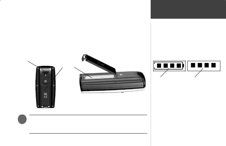
Installing the Batteries
The Geko 201 operates on two AAA batteries (not included), installed in the back of the unit. To install the batteries, remove the battery cover by inserting a coin in the bottom slot. Twist the coin to lift the cover up and pull away. Insert the batteries, observing proper polarity. Attach the battery cover by inserting the tab end into the back slot at an angle, laying it flat, and then pushing it forward until the clip catches. Alkaline batteries should last as long as 12 hours. Rechargeable Alkaline, NiMH, NiCad or Lithium batteries may be used, but cannot be charged while in the unit.
External power and data connector (under rubber tab)
Battery
Compartment
)NOTE: If you intend to store your Geko 201 for an extended period of time, remove the batteries. Follow the battery manufacturer’s instructions for the proper care and handling of the batteries.
Introduction
Installing Batteries
Battery usage icon shows an estimate of battery life left. Four squares with the battery outline indicates a full battery.
Four squares alone indicates the use of an external power source.
v
Introduction
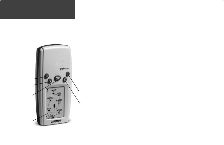
Geko 201 Buttons
UP Button
DOWN Button
OK
Button
LCD Display
(with backlight)
The UP/DOWN Buttons:
•Press to highlight options on pages and menus
•Press to adjust display contrast on the Satellite Page
•Press to Zoom out (UP) and in (DOWN) on the Map Page
•Press to cycle through the data fields on the Navigation Page The OK Button:
•Press to confirm data entry or menu selection
•Press and hold to Mark your current position and access the Mark Waypoint Page
The POWER Button:
•Press and hold to turn the unit on and off
•Press and release (with the unit on) to turn the backlight on and off The PAGE Button:
•Press to switch between the Main Pages
•Press to ‘undo’ for the most recent action
POWER
Button
PAGE
Button
vi

Main Pages
All of the information needed to operate the Geko 201 is found on five main ‘pages’ (or display screens). These pages are the Satellite, Map, Navigation, Trip Computer, and Menu.
Press the PAGE Button to switch between pages.
Main Pages
Main Pages Basics
Satellite |
Map |
Navigation |
Trip Computer |
Menu |
1

Satellite Pages
Page Basics
A “READY TO NAVIGATE” |
About Geko |
|
message must display before |
||
|
||
you can begin using your |
|
|
Geko 201 to navigate. |
|
)NOTE: When you use the
Geko 201 for the first time, allow time for it to track satellites by leaving the Geko 201 outside with a clear view of the sky for 15-30 minutes.
2
Normal Skyview |
Advanced Skyview |
Status Message
Location Accuracy
(estimated)
Satellites
Satellite Signal Strength Bars (a ‘D’ stands for differential corrections and denotes a WAAS Satellite)
The ‘3D’ displays when receiving signals from four or more satellites.
The Satellite Page shows the Geko 201 gathering all the necessary satellite information in order to work. There are two display options on the Satellite Page, Normal Skyview and Advanced Skyview. Normal Skyview shows you (in animation), the satellites, satellite signal strength, and the Geko 201’s estimated location accuracy.
To activate the Advanced Skyview page, press the OK Button on the Satellite Page, select ‘Advanced Skyview’ and press the OK Button again. This page displays the numbered satellites the Geko 201 is using, their proximity to your current position, and their individual strengths. The outer circle of the display represents the horizon and the center represents the sky directly overhead to help you determine the location of the satellites.
When you see the “READY TO NAVIGATE” message on the Satellite Page, the Geko 201 has found your location and you are ready to go!
To see the software version that the Geko 201 is currently using, press the OK Button on the Satellite Page and select ‘About Geko’. (A PC-compatible computer and Power/Data cable, not included, are required to update the software.)
Backlighting
If lighting conditions make it hard for you to see the screen, you can turn on the backlight. Press and release the POWER Button from any screen to turn on the backlight. The backlight is timed to stay on for 30 seconds to save battery power.
To adjust the backlight’s timeout setting:
1.Press the UP or DOWN Button while on the Menu Page to highlight ‘SETUP’ and press the OK Button to display the Setup Page.
2.Press the UP or DOWN Button to highlight ‘DISPLAY’ and press the OK Button twice to display the Light Timeout options.
3.Press the UP or DOWN Button to highlight the length of time and then press the OK Button to return to the Display Page.
Contrast
The screen contrast is quickly adjustable from the Satellite Page. You can also adjust the contast from the Setup Page of the System Menu Page (See Page 26).
To adjust the contrast from the Satellite Page:
1.Press the UP or DOWN Button while on the Satellite Page to display the Contrast Window.
2.Press the UP or DOWN Button to move the contrast slider. Continue to press the UP Button to make the screen darker or press the DOWN Button to make the screen lighter.
3.Press the OK Button to return to the Satellite Page.
Satellite Pages
Options
Light Timeout Options
Contrast Slider
3
Map Page
Page Basics
When on the Map Page, the UP and DOWN Buttons are used to adjust the map scale from 50 feet to 800 miles.
4
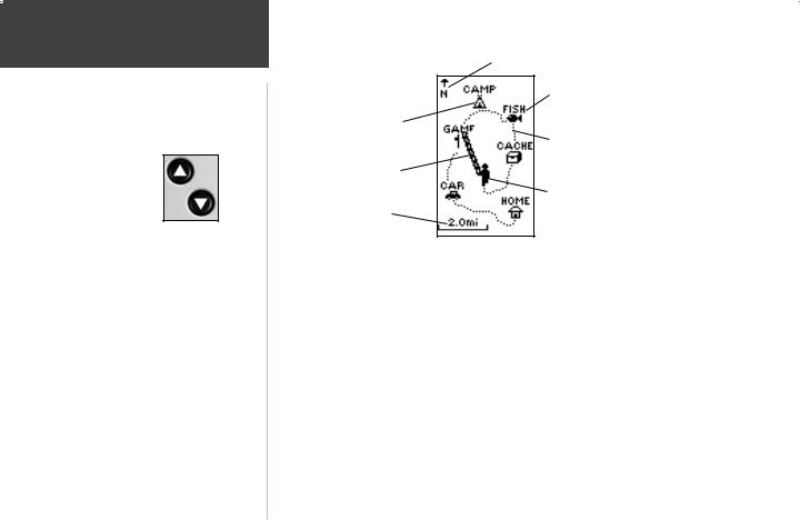
Heading Indicator
Waypoint
Waypoint Name
Symbol
‘Trail’
(track log)
Path to
Destination
‘You’
Map (your location)
Scale
The Map Page shows where you are (the animated figure) and provides a picture of where you are going. As you travel (the animated figure ‘walks’) and leaves a ‘trail’ (track log). Waypoint names and symbols are also shown on the map.
To help you better visualize the ‘real world’, the Geko 201 automatically rotates the map as you move, so that waypoints that are ahead of you are always displayed in front of the animated figure. The Heading Indicator shows the direction you are heading.
To make sure you can see your entire route, you can change the map scale (from 50 feet to 800 miles) by pressing and holding the UP Button to view a larger area, and the DOWN Button for viewing a smaller area.

The Options on the Map Page allow you to customize the page in several ways although not all options are visible all the time. The following options are always available:
•Clear Track Log: Allows you to clear the track log and immediately start a new one.
•Measure Distance: Allows you to choose two way (the default for one is your current position) and then select a second waypoint. The distance, estimated time needed to reach that point, and your current estimated speed is calculated automatically.
•Map Setup: Allows you to adjust the map settings including:
Orient Map (Ahead or Northward): When ‘AHEAD’ is selected, the top of the map is oriented in the direction you are currently moving. When ‘NORTHWARD’ is selected, the map is always oriented to the North.
Auto Zoom (On or Off): When ‘AUTO ZOOM’ is turned on, the map automatically adjusts its scale to display your entire navigating route until you manually change the zoom level. When it’s turned off, you must press the UP or DOWN Button to select the appropriate map scale.
Waypoints (Show or Hide): Allows you to view the map with or without waypoints.
Goto Line (Bearing or Course): Determines whether the display pointer shows your current bearing or the direction to the next waypoint.
Options that do not display until you have a track log or are actively navigating include:
•Pan Track Log: Allows you to move the pointer to any point along the track and then start a TRACBACK, a GOTO, MARK a waypoint, or ZOOM In or Out.
•Stop Navigation: ‘STOP NAVIGATION’ stops any active navigation (navigation means there is a destination waypoint).
Map Page
Options
Selecting ‘PAN TRACK LOG’ from the Map Page options allows you to move the pointer to any point on the track log and then create a Waypoint or navigate to it.
When you select ‘Orient Map Northward’ the figure icon is replaced by a ‘direction’ triangle. The tip of the triangle tells you the general direction in which you are moving.
5

Map Page
Options
‘CLEAR’ the track log before starting a new trip.
PanTrack™ mode
6
Using the Track Log
The Geko 201 draws an electronic breadcrumb trail or ‘track log’ on the Map Page as you travel. The track log starts recording as soon as the Geko 201 gets a location fix.
To make use of the track log, select the ‘PAN TRACK LOG’ option to show a pointer which moves along the track log when you press the UP or DOWN Button. Press the OK Button to see the four choices ‘TRACBACK’, ‘GOTO’, ‘MARK’ and ‘ZOOM’.
‘TracBack’ will guide you to where you started by following the track log that you left behind, allowing you to return along a traveled path without marking any waypoints. For the best results, clear the track log before you start traveling because when the track log is full, the new track points will overwrite the oldest track points.
‘Goto’ guides you from your current location to the waypoint selected while ‘Mark’ creates a new waypoint for later use. ‘Mark’ is explained in detail beginning on Page 11. ‘Zoom’ adjusts the level of viewable map detail.
To clear the track log:
1.From the Map Page, press the OK Button to display the Map Page Options menu.
2.Press the UP or DOWN Button to highlight ‘CLEAR TRACK LOG’ and press the OK Button.
3.At the message “DO YOU REALLY WANT TO CLEAR THE TRACK LOG?”, use the DOWN Button to highlight ‘YES’ and press the OK Button to clear the track log and return to the Map Page.
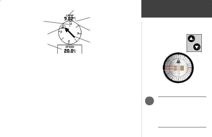
Waypoint (Destination) Name
Moving Direction |
|
Straight Line |
|
||
|
Distance to the |
|
Line |
|
|
|
Destination |
|
|
|
|
Destination |
|
Compass Ring |
Symbol |
|
|
Data field |
|
Direction Arrow |
|
(follow this) |
|
|
|
|
|
|
|
The Navigation Page guides you to a destination. When you’re moving with no particular destination in mind, the Navigation Page displays a subset of information. When you’re moving towards a specific destination, however, the Navigation Page displays additional information
in the data fields, such as the name of the location, the distance and time to go, and displays a direction arrow in the compass ring. To navigate, simply follow the arrow.
Navigation Page Options
The Navigation Page option ‘STOP NAVIGATION’ only displays when you press the OK Button while actively navigating to a Waypoint.
The list of data fields is on the next page.
Navigation Page
Page Basics
On the Navigation Page, the UP and DOWN Buttons are used to cycle through different trip data.
The Geko 201 is not a true magnetic compass! You must be moving in order for it to track your movement.
)NOTE: The direction arrow, destination symbol, bearing information, Time To Go, Arrival Time and Final Distance only display when you have started a Goto or a TracBack.
7

Navigation Page
Options
The Navigation Page allows you to display 10 types of different data, such as ‘Elevation’, ‘Speed’, etc.
8
Data Field Options
By pressing the UP or DOWN Button, you can cycle through the Data fields at the bottom of the Navigation Page:
•Elevation—the measurement of height above mean sea level.
•Heading—the direction you are traveling.
•Location—shows your current location coordinates, UTM, latitude and longitude, etc.
•Speed—tells you how fast you are going.
•Time/Date—the current time and date based on your Time Zone settings.
•Trip Odometer—the total distance you’ve gone since the last reset.
The following fields display only when navigating:
•Arrival Time—the time of your arrival, based on your current speed and distance left.
•Bearing—the compass direction from your current location to your destination.
•Final Distance—the route distance left from your current location to your destination.
•Time To Go—the estimated time at your current speed to reach your destination.
 Loading...