


 Loading...
User Manual
Pioneer AVIC-S2
Navigation software for AVIC-S2
UK English
March, 2007 (v 0.1)
Copyright note
The product and the information contained herein may be changed at any time without prior notification.
This manual nor any parts thereof may not be reproduced or transmitted in any form either electronically or mechanically, including photocopying and recording, without the express written consent of Pioneer.
Whereis® map data is © 2006 Telstra Corporation Limited and its licensors
Data Source © 2006 Tele Atlas N.V.
© Copyright 2007, PIONEER Corporation
All rights reserved.
2
Before using your navigation system, be sure to read and fully understand the information provided in the "Important Information for the User" document. Read the entire User Manual before operating this navigation system.
3
Table of Contents
1 Warnings and safety information......................................................................... |
8 |
||||
2 |
General information............................................................................................. |
9 |
|||
3 |
Operating AVIC-S2 (Controls)........................................................................... |
10 |
|||
|
3.1 |
Hardware buttons....................................................................................... |
10 |
||
|
3.1.1 |
Power on/off button............................................................................. |
10 |
||
|
3.1.2 |
Menu button........................................................................................ |
10 |
||
|
3.1.3 |
Map button.......................................................................................... |
11 |
||
|
3.1.4 |
Volume setting scroll wheel ................................................................ |
11 |
||
|
3.2 Screen buttons and controls ...................................................................... |
11 |
|||
|
3.2.1 |
List selectors....................................................................................... |
11 |
||
|
3.2.2 |
Sliders................................................................................................. |
12 |
||
|
3.2.3 |
Switches ............................................................................................. |
12 |
||
|
3.2.4 |
Switches in the Display menu ............................................................. |
12 |
||
|
3.2.5 |
Virtual keyboards ................................................................................ |
13 |
||
|
|
3.2.5.1 |
ABC-type keyboards ....................................................................... |
13 |
|
|
|
3.2.5.2 |
QWERTY-type keyboards ............................................................... |
14 |
|
|
|
3.2.5.3 |
The numeric keyboard..................................................................... |
14 |
|
4 Discovering the program through the screens .................................................. |
15 |
||||
|
4.1 |
The map..................................................................................................... |
15 |
||
|
4.1.1 |
2D and 3D map views......................................................................... |
15 |
||
|
4.1.2 |
Zoom levels ........................................................................................ |
16 |
||
|
4.1.3 |
Daylight and night colour schemes ..................................................... |
16 |
||
|
4.1.4 |
Streets and roads ............................................................................... |
17 |
||
|
4.1.5 |
Other objects ...................................................................................... |
18 |
||
|
4.1.6 |
Current position and Lock-on-Road .................................................... |
18 |
||
|
4.1.7 |
Selected map point, also known as the Cursor................................... |
19 |
||
|
4.1.8 |
Marked map points (Pin)..................................................................... |
19 |
||
|
4.1.9 |
Visible POIs (Points of Interest) .......................................................... |
20 |
||
|
4.1.10 |
Road safety cameras.......................................................................... |
21 |
||
|
4.1.11 |
Elements of the Active Route.............................................................. |
21 |
||
|
|
4.1.11.1 The start point, via points and the destination ............................. |
21 |
||
|
|
4.1.11.2 |
Animated turn guidance............................................................... |
21 |
|
|
|
4.1.11.3 The active leg of the route ........................................................... |
22 |
||
|
|
4.1.11.4 Inactive legs of the route.............................................................. |
22 |
||
|
|
4.1.11.5 Roads in the route excluded by your preferences ....................... |
23 |
||
|
4.2 |
GPS Data screen ....................................................................................... |
23 |
||
|
4.2.1 |
GPS data displayed ............................................................................ |
23 |
||
|
4.2.2 |
GPS connection indicator ................................................................... |
24 |
||
|
4.2.3 |
GPS data quality indicator .................................................................. |
24 |
||
|
4.2.4 |
Time synchronization.......................................................................... |
24 |
||
4
4.3 |
Screens with map ...................................................................................... |
25 |
||
4.3.1 |
Turn preview (No. 1) ........................................................................... |
27 |
||
4.3.2 |
Zoom in and out (No. 2 & 3)................................................................ |
27 |
||
4.3.3 |
Tilt up and down (No. 4 & 5) ............................................................... |
27 |
||
4.3.4 |
Back to navigation - lock to GPS position and heading (No. 6)........... |
28 |
||
4.3.5 |
Cursor (No. 7) ..................................................................................... |
29 |
||
4.3.6 |
Map scale (No. 8) ............................................................................... |
29 |
||
4.3.7 |
Navi button - Menu (No. 9).................................................................. |
29 |
||
4.3.8 |
Map orientation and Overview (No. 10) .............................................. |
29 |
||
4.3.9 |
GPS position quality (No. 11).............................................................. |
30 |
||
4.3.10 |
Battery status (No. 12)........................................................................ |
31 |
||
4.3.11 |
Sound muting (No. 13)........................................................................ |
31 |
||
4.3.12 |
Track Log recording/playback indicator (No. 14) ................................ |
31 |
||
4.3.13 |
Cursor menu (No. 15) ......................................................................... |
32 |
||
4.3.14 |
Current street (No. 16)........................................................................ |
33 |
||
4.3.15 |
Travel and Route data (No. 17) .......................................................... |
33 |
||
4.3.16 |
Distance to next turn (No. 18) ............................................................. |
34 |
||
4.3.17 |
Next street / Next manoeuvre (No. 19) ............................................... |
34 |
||
4.3.18 |
Approaching next turn (No. 20)........................................................... |
34 |
||
4.3.19 |
Mode button (No. 21).......................................................................... |
34 |
||
4.4 |
Route Information screen........................................................................... |
35 |
||
4.4.1 |
Route data displayed (for destination and via points) ......................... |
35 |
||
|
4.4.1.1 |
Route line ........................................................................................ |
35 |
|
|
4.4.1.2 |
Distance Left ................................................................................... |
36 |
|
|
4.4.1.3 |
Method ............................................................................................ |
36 |
|
|
4.4.1.4 |
Time Left ......................................................................................... |
36 |
|
|
4.4.1.5 |
Estimated Arrival ............................................................................. |
36 |
|
|
4.4.1.6 Destination / Via point ..................................................................... |
36 |
||
4.4.2 |
Warning icons ..................................................................................... |
36 |
||
4.4.3 |
Fit to screen ........................................................................................ |
38 |
||
4.4.4 |
Parameters ......................................................................................... |
38 |
||
4.5 |
Menu |
.......................................................................................................... |
38 |
|
4.5.1 |
Destination tab.................................................................................... |
38 |
||
4.5.2 |
Display ..........................................................................................tab |
38 |
||
|
4.5.2.1 ...................................................................................... |
3D/2D Map |
39 |
|
|
4.5.2.2 .........................................................................Zoom & Tilt (switch) |
39 |
||
|
4.5.2.3 ........................................................................... |
Day/Night (switch) |
39 |
|
|
4.5.2.4 ......................................................Manage POI (Points of Interest) |
40 |
||
|
4.5.2.5 .............................................................. |
Popup Information (switch) |
43 |
|
|
4.5.2.6 ......................................................................... |
Manage Track Logs |
43 |
|
4.5.3 |
Route ............................................................................................tab |
45 |
||
|
4.5.3.1 ..................................................................................... |
Recalculate |
45 |
|
|
4.5.3.2 .............................................................................................. |
Delete |
47 |
|
|
4.5.3.3 ........................................................................................... |
Itinerary |
47 |
|
|
4.5.3.4 ........................................................................................... |
Fly Over |
48 |
|
|
4.5.3.5 .................................................................................................. |
Edit |
49 |
|
|
4.5.3.6 .................................................................................................. |
Info |
49 |
|
4.5.4 |
Map .............................................................................Search button |
50 |
||
4.5.5 |
Settings ....................................................................................button |
50 |
||
4.6 TMC (Traffic ................................................................Message Channel) |
50 |
|||
5
4.6.1 |
List of TMC messages ........................................................................ |
51 |
|
4.6.2 |
TMC control centre ............................................................................. |
51 |
|
|
4.6.2.1 Selected FM radio station................................................................ |
51 |
|
|
4.6.2.2 |
Exclude selected station.................................................................. |
51 |
|
4.6.2.3 |
Show excluded stations................................................................... |
52 |
|
4.6.2.4 Sorts events by distance / type ....................................................... |
52 |
|
|
4.6.2.5 |
Use traffic information ..................................................................... |
52 |
|
4.6.2.6 Recalculate to avoid traffic .............................................................. |
52 |
|
4.7 |
Road safety cameras ................................................................................. |
52 |
|
4.7.1 |
Camera types ..................................................................................... |
53 |
|
|
4.7.1.1 |
Fixed cameras................................................................................. |
53 |
|
4.7.1.2 |
Mobile cameras............................................................................... |
53 |
|
4.7.1.3 |
Built-in cameras .............................................................................. |
54 |
|
4.7.1.4 |
Section control cameras.................................................................. |
54 |
|
4.7.1.5 |
Red light cameras ........................................................................... |
54 |
4.7.2 |
Controlled traffic direction ................................................................... |
55 |
|
4.7.3 |
Speed limit checked ............................................................................ |
55 |
|
4.7.4 |
Add a new camera or edit an existing one .......................................... |
55 |
|
5 Settings |
|
57 |
|
5.1 |
Safety ...........................................................................................settings |
57 |
|
5.1.1 ........................................................................................ |
Safety Mode |
57 |
|
5.1.2 ......................................................................... |
Warn When Speeding |
58 |
|
|
5.1.2.1 ......................................................................... |
Speeding tolerance |
58 |
|
5.1.2.2 ..................................................................... |
Alternative speed limit |
58 |
|
5.1.2.3 ........................................................ |
Alternative speeding tolerance |
59 |
5.1.3 ...................................................................... |
Enable Safety Cameras |
59 |
|
|
5.1.3.1 .............................................................................. |
Audible Warning |
59 |
|
5.1.3.2 ............................................................................... |
Visible Warning |
60 |
5.2 |
Map ...................................................................................Colour settings |
60 |
|
5.2.1 .............................................................. |
Daylight / Night colour profile |
60 |
|
5.2.2 ..................................................................... |
Automatic Night Colours |
61 |
|
5.3 |
Sound ...........................................................................................settings |
61 |
|
5.3.1 ............................................................................ |
Click Sounds switch |
61 |
|
5.3.2 ................................................................................. |
Dynamic Volume |
61 |
|
5.3.3 .................................................................................... |
Attention Tone |
62 |
|
5.4 |
Route ...........................................................................parameter settings |
62 |
|
5.4.1 .................................................................................................. |
Route |
62 |
|
|
5.4.1.1 ................................................................................................ |
Short |
62 |
|
5.4.1.2 ................................................................................................. |
Fast |
62 |
|
5.4.1.3 ...................................................................................... |
Economical |
62 |
5.4.2 ................................................................................................ |
Vehicle |
63 |
|
5.4.3 ............................................................ |
Road types to include/exclude |
63 |
|
|
5.4.3.1 .............................................................................. |
Unpaved Roads |
63 |
|
5.4.3.2 ......................................................................................... |
Freeways |
63 |
|
5.4.3.3 ............................................................................................. |
Ferries |
63 |
|
5.4.3.4 ............................................................................................ |
U-turns |
63 |
|
5.4.3.5 ................................................................................. |
Permit needed |
64 |
|
5.4.3.6 ....................................................................................... |
Toll Roads |
64 |
5.4.4 ........................................................................ |
Cross - border planning |
64 |
|
5.5 |
Language................................................................................................... |
64 |
|
6
|
5.5.1 |
Program language .............................................................................. |
64 |
|
|
5.5.2 |
Voice language ................................................................................... |
64 |
|
|
5.6 Advanced settings...................................................................................... |
65 |
||
|
5.6.1 |
Regional settings ................................................................................ |
65 |
|
|
5.6.1.1 |
Units ................................................................................................ |
65 |
|
|
5.6.1.2 |
Coordinate display format ............................................................... |
65 |
|
|
5.6.1.3 Set Date & Time Format.................................................................. |
65 |
||
|
5.6.2 |
Displayed information ......................................................................... |
66 |
|
|
5.6.3 |
Smart Zoom ........................................................................................ |
66 |
|
|
5.6.3.1 |
Smart Zoom switch.......................................................................... |
66 |
|
|
5.6.3.2 |
Enable Overview mode ................................................................... |
67 |
|
|
5.6.3.3 Keep position on road (Lock-on-Road)............................................ |
67 |
||
|
5.6.4 |
Set Favourite Destinations.................................................................. |
67 |
|
|
5.6.5 |
User data management ...................................................................... |
68 |
|
|
5.6.5.1 |
Backup Data.................................................................................... |
68 |
|
|
5.6.5.2 |
Restore Data ................................................................................... |
68 |
|
|
5.6.5.3 |
Clear Data ....................................................................................... |
68 |
|
|
5.6.5.4 |
Reset Advanced Settings ................................................................ |
69 |
|
|
5.6.6 |
About screen....................................................................................... |
69 |
|
6 |
Find your destination......................................................................................... |
70 |
||
|
6.1 Selection by tapping the map..................................................................... |
70 |
||
|
6.2 Using the Destination menu....................................................................... |
70 |
||
|
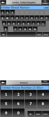
6.2.1 |
Find an Address, Street, Intersection or City ...................................... |
71 |
|
|
6.2.1.1 Selecting the city, state and country to search in ............................ |
71 |
||
|
6.2.1.2 Selecting a street or the centre of the settlement ............................ |
74 |
||
|
6.2.1.3 Selecting a house number or the midpoint of the street .................. |
75 |
||
|
6.2.1.4 How to select an intersection instead of a house number ............... |
75 |
||
|
6.2.2 |
Find in History..................................................................................... |
76 |
|
|
6.2.3 |
Find Coordinates ................................................................................ |
76 |
|
|
6.2.4 |
Find a POI........................................................................................... |
77 |
|
|
6.2.5 |
Find one of the Favourites (Home/Office)........................................... |
79 |
|
7 |
Troubleshooting guide....................................................................................... |
80 |
||
8 |
Glossary |
............................................................................................................ |
|
82 |
7
1 Warnings and safety information
 The features of this Navigation System are intended solely as an aid to you. It is not a substitute for your attentiveness, judgement, and care when driving or when otherwise operating this Navigation System.
Do not operate this Navigation System if doing so in any way will divert your attention from the safe operation of your vehicle or other mode of transportation. Only a passenger should program/operate this Navigation System while a vehicle is moving. A driver should use voice guidance (when available) or glance at the screen only when it is necessary and safe to do so. If prolonged viewing of the screen or programming/operation of the unit is required by the driver, do so only when the vehicle is parked in a safe location. Always observe safe driving/operating rules and follow all existing traffic regulations.
This Navigation System may in certain circumstances display inaccurate or incomplete information regarding your position, the distance of the objects shown on the screen, and compass directions. In addition, the system has certain limitations, including the inability to identify certain one-way streets, temporary traffic restrictions, road and weather conditions, traffic flow, and potentially unsafe driving areas.
Recent changes to streets/highways also may not be reflected in this database. Please exercise your own careful judgement in the light of actual conditions and traffic laws/regulations.
Before using your navigation system, be sure to read and fully understand the information provided in the "Important Information for the User" document. Read the entire User Manual before operating this navigation system.
8
2 General information
AVIC-S2 is a navigation system optimised for in-car use. It provides door-to-door navigation for both single and multi-point routes using adaptable route parameters. AVIC-S2 is capable of planning routes throughout the whole installed map set. Unlike some other products, AVIC-S2 does not require that you change maps or switch to a poorly detailed general map to navigate between map segments or countries. You always have complete freedom to go wherever you wish. Just select your destination and go.
You do not need a stylus to use AVIC-S2. All screen buttons and controls are designed so that you can operate them with your fingertips.
You can access all functions of the program by using hardware and screen buttons.
With the help of these buttons you can travel through all the screens of the program.
Most of the screens (especially menu functions and settings) can be accessed from several other screens, minimising the number of actions needed to reach the desired function.
When using AVIC-S2, you do not need to ‘double tap’ or ‘tap & hold’ the touch screen as these functions cannot be used reliably in a moving vehicle. A single tap triggers most of the screen controls. The only exceptions are ‘drag & drop’ for moving the map, scaling it in Map mode (Page 29), or some Music Player functions.
Most of the screens have a Return button  in the top left corner. This arrow returns to the previous screen or directly to one of the map screens.
Settings screens also have a Help button  in the top right corner. This will show a detailed description of the current settings screen.
9
3 Operating AVIC-S2 (Controls)
AVIC-S2 is designed for easy operation. All controls are operable by fingertips.
Wherever possible, pushbuttons and lists are provided to make accessing functions or changing settings as easy as possible.
3.1 Hardware buttons
There are only a few hardware buttons on your AVIC-S2.
The majority of the AVIC-S2 functions can be accessed using the touch screen. The hardware buttons are the following:
3.1.1 Power on/off button
Hold this button for 3 seconds to turn the power of the AVIC-S2 on or off any time.
If the device power is turned off while the navigation software is running, when you turn the device back on, the program will continue the navigation as soon as the built-in GPS determines the location again.
While the device is switched off, the GPS will not work, no position will be calculated, track log will not be saved, and navigation will stop.
3.1.2 Menu button
Use this button to pause navigation, and return to the startup menu of your AVIC-S2 to run Bluetooth application.
While using other applications, the GPS will continue providing the position, the track log will be continuously saved, and navigation will not stop.
When you return to the navigation function, AVIC-S2 will continue the navigation as soon as the built-in GPS determines the location again.
10
3.1.3 Map button
To give easy access to the most important data screens during navigation, a hardware button is reserved for toggling between the Route Information screen and the Detailed Instructions page of the Itinerary. Alternatively, these screens can be accessed from the Route menu by the Info (Page 49) and Itinerary (Page 47) buttons respectively.
As a secondary function press and hold this button for 3 seconds to toggle between the Cockpit and the Map screens (Page 25).
3.1.4 Volume setting scroll wheel
As in other applications of your AVIC-S2, this scroll wheel will adjust the master volume of AVIC-S2. Turn this wheel to make navigation and key sounds louder or to turn them down. When you use this control, the new master volume level will be displayed in the centre of the screen for a few seconds.
3.2 Screen buttons and controls
The primary input for the AVIC-S2 is the touch screen. If you continue to read this manual, you will realise that most parts of the screen are not only used to display information but also to initiate functions by tapping. Below you will find a list of the most frequently used controls in the program.
3.2.1 List selectors
Some of the settings can be chosen from a short list of possible values. The current value is shown in a horizontal strip with arrows at both ends.
The arrows are buttons. Tap  to move left in the list or tap
  to move right. You do not need to confirm your selection. As soon as you leave the screen, the selected value becomes effective.
11

3.2.2 Sliders
When a feature has several different unnamed (numeric) values, AVIC-S2 will show sliders that look like analogue gauge to set the desired value.
If the value limits are not displayed at the ends of the slider, the leftmost position means the minimum value, while the rightmost position represents the maximum value.
With most sliders you can check the current value on the left.
This control can be operated in two ways. Either drag the handle to move the slider to its new position, or tap the slider where you want the handle to appear (the thumb jumps there immediately). As with the list selectors, there is no need to confirm your selection. As soon as you leave the screen, the selected value becomes effective.
3.2.3 Switches
When a function can only have two values (mainly Enabled and Disabled), a switch is used. Unlike with list selectors, the horizontal line contains the name of the function and not the actual status. There is a lamp on the left to show whether the function is active or not.
When the lamp is dark  , the function is not selected. When it is lit
  , the function is enabled. The whole strip works as a button. Tap anywhere to toggle between the enabled and disabled status.
3.2.4 Switches in the Display menu
The switches of the Display menu (Page 38) behave as normal switches but they look different in order to fit in with the other menu buttons.
Tap the button to toggle between the enabled and disabled states.
12

3.2.5 Virtual keyboards
AVIC-S2 is designed in a way that you only need to enter letters or numbers when it is inevitable. In these cases a full screen keyboard pops up that can easily be operated with your fingertips. You can choose between a separate ABC and numeric keypad, or a set of QWERTY-type keyboards that contain both letters and numbers. AVIC-S2 will remember your last choice and offer it the next time you need to enter data.
The alphabetic keyboards in AVIC-S2 do not contain special characters, because you do not need to enter accents when searching for a destination. Type only the base letters (the letter most similar to the accented one) and AVIC-S2 will search for all their combinations in the database (e.g. for the French street ‘Cité Bergère ’ you only need to type ‘Cite Bergere’, and the rest is done by the program).
When you type in POI or track log names, AVIC-S2 will automatically turn all initials into capitals to create names that look pleasant.
3.2.5.1 ABC-type keyboards
These keyboards contain only letters (Latin, Greek or Cyrillic). If you wish to enter numbers, you need to tap the Keys ( ) button to switch to the numeric keyboard.
Use Backspace (arrow pointing left) to delete the last letter you have entered if you have made a mistake, tap Space to enter more words, and hit Done to finish entering the text.
This type of keyboard has large, finger-friendly buttons.
Note: If you have chosen a program language that uses Latin letters, only the ABC keyboard appears. If you choose the Greek language, an additional keyboard appears with Greek letters. Similarly Cyrillic letters are available when Russian is chosen in Setup / Languages (Page 64).
If you are used to computer keyboards, you may consider trying one of the
QWERTY-type keypads.
13
3.2.5.2 QWERTY-type keyboards
QWERTY-type keyboards have both letters and numbers on them. Their layout is the same as of the standard QWERTY, QWERTZ (German) and AZERTY (French) keyboards. To switch to your desired QWERTY-type keyboard, press the Keys button repeatedly until the appropriate keyboard appears.
The special keys described in the previous section are also available here.
3.2.5.3 The numeric keyboard
The numeric keyboard only contains numbers, on huge buttons. The special keys you find on the other keyboards (except Space) are available here as well.
Although QWERTY-type keyboards also contain number keys, when entering a house number, the program offers the more convenient numeric keypad.
14
4 Discovering the program through the screens
The best way to learn the different functions of the AVIC-S2 is to explore each screen in detail, and to find out how to move from one to another. Read this chapter for a guided tour.
4.1 The map
The most important and most frequently used screens of AVIC-S2 are the screens with the map (Map and Cockpit screens). The elements of the map are described here. For the controls and special functions of the map screen see Page 25.
The current version of AVIC-S2 is intended only for in-vehicle navigation. That is why maps in AVIC-S2 look similar to paper roadmaps (when using daytime colours and 2D map mode). However, AVIC-S2 provides much more than regular paper maps can. The look and the contents can be changed.
4.1.1 2D and 3D map views
Besides the classical top down view of the map (called 2D mode), you have the ability to tilt the map to have a perspective view (3D mode) that gives a view similar to that seen through the windscreen with the ability to see far ahead.
It is easy to change between 2D and 3D modes. You have two options. You can use the Tilt up and down buttons (Page 27) to tilt the map seamlessly between 2D and all 3D angles, or you can use the switch in the Display menu (Page 39) to quickly switch between the two modes.
15

Note: You may find that 2D mode is more useful in North-up Map mode when looking for a certain part of the map or an object to select as destination. On the other hand, 3D mode in Track-up Cockpit mode with Smart Zoom is ideal for navigation. The description of these modes will come later in this manual.
Note: 3D view is only useful for navigation. As you zoom out, the view angle will automatically be raised, until eventually it becomes 2D view. When you zoom back in, 3D view will gradually return.
4.1.2 Zoom levels
AVIC-S2 uses high quality vector maps that let you see the map at various zoom levels, always with optimised content. Street names and other text objects are always displayed with the same font size, never upside down, and you only see as many streets and objects as needed to find your way around the map. Zoom in and out to see how the map changes in either the 2D or 3D view.
Changing the scale of the map is very easy. Use the zoom icons (Page 27) on the map screens.
Note: If you need to zoom out temporarily to locate your position on the map, use the
Overview mode instead of zooming out/in. The Overview mode is a 2D North-up view that can be activated by tapping the compass button on the right (Page 29).
Note: AVIC-S2 has a Smart Zoom function for navigation that automatically rotates, scales and tilts the map in 3D map mode to always give you the optimal view in your current situation. When approaching a turn, it will zoom in and raise the view angle to let you recognise your manoeuvre at the next junction. If the next turn is at a distance, it will zoom out and lower the view angle to flat in order to let you see the road in front of you.
4.1.3 Daylight and night colour schemes
The different colour schemes let you adjust AVIC-S2 to the brightness of the environment. Use the daylight and night colour schemes accordingly. Daylight colours are similar to paper roadmaps, while the night colour schemes use dark tints for large objects to keep the average brightness of the screen low, with carefully
16
selected colours to still keep you informed about all the necessary information on the screen.
You can change between day and night views manually in the Display Menu (Page 39) or let AVIC-S2 do it automatically (Page 61) for you.
Note: The automatic day/night mode is based upon the current date and GPS position by which AVIC-S2 calculates the exact sunrise and sunset times on the particular day at the particular location. Using that information AVIC-S2 can automatically switch between the colour schemes a few minutes before sunrise, when the sky has already turned bright, and a few minutes after sunset before it gets dark.
Tip: There are several daytime and night colour schemes included with AVIC-S2. To select the one that suits your needs the best, make your selection in Settings (Page 60).
Note: The colours mentioned and screenshots included in this manual refer to the default daytime and night colour schemes. They may not look the same in the schemes you have chosen.
Tip: If you use AVIC-S2 after sunrise or before sunset, look for the sun in the sky in the map background using a flat 3D view. It is displayed at its actual position to give you another way to orientate.
4.1.4 Streets and roads
The similarity of AVIC-S2 to paper roadmaps is also convenient when it comes to streets, the most important elements of the map concerning navigation. AVIC-S2 uses similar colour codes to those you are accustomed to, and the width of the
17

streets also refers to their importance, so it will not be difficult to tell a highway from a small street.
Streets and roads have names or numbers for identification. Of course, this information can be displayed on the map. AVIC-S2 uses two different ways to show street labels. The conventional way is the same as a roadmap – it displays the name of the street aligned with the street. The alternative is a kind of virtual signpost stuck into the street itself.
You do not need to choose between the two modes. AVIC-S2 will use the one best for the current tilt and zoom level. Zoom in to have only a few streets on the map, and start tilting up and down to see how AVIC-S2 switches between the two modes in an instant.
Note: The automatic switching is on even when using Smart Zoom.
4.1.5 Other objects
To help orientate you, the map also contains land usage information that help you recognise your location on the map. These are surface-waters, large buildings, forests, etc.
4.1.6 Current position and Lock-on-Road
When your GPS position is available, a red arrow shows your location on the map.
The direction of the arrow represents your direction. The arrow size and orientation is rotated with the zoom and tilt levels to always fit appropriately on the map.
18

AVIC-S2 has a built-in Lock-on-Road feature that always puts the position arrow on the road, on the axis of the street in case of one-way streets, or on the side of the road where you drive (e.g. on the right in the United States, and on the left in the
U.K.) on two-way roads.
Note: The Lock-on-Road feature can be turned off in Advanced settings (Page 67).
When the GPS position is lost, the arrow turns gray, but the indicator continues on the recommended route for a short period of time with the speed last detected before the GPS position was lost. This way short tunnels can be crossed without losing the position.
4.1.7 Selected map point, also known as the Cursor
If you tap the map somewhere or select a specific item in Destination, it will become the selected point on the map, marked with a small red dot and permanently radiating red circles to make it conspicuous at all zoom levels, even when it is in the background of a 3D map view. You can use this point as starting point, via point, or destination of your route, you can search for a POI near to it, or save it as a POI. The cursor, when visible, is also the reference point for map scaling.
Note: When your GPS position is available, and Lock-to-Position (Page 28) is active, the cursor is the current GPS position, the red arrow. When you select another point by tapping the map, or using the Destination menu (Page 70), the new Cursor is shown on the display with the red dot and the radiating red circles.
4.1.8 Marked map points (Pin)
The Cursor can be marked with a Pin. Pins are shown as being stuck in the map. A Pin is visible at all zoom levels and remains in its position until you unpin it.
19

The colour of the Pin is automatically selected by AVIC-S2. Different colours help you identify a Pin in the History list (Page 76) later. There they are shown together with their address and GPS Coordinates.
Tip: A quick way to tell the coordinates of a location you found on the map is to Pin it, and then look for the coordinates in the History list (Page 76).This way you also save the coordinates with the Pin for later reference. If you do not need the coordinates later, just select the point and start Find Coordinates (Page 76).
4.1.9 Visible POIs (Points of Interest)
AVIC-S2 comes with thousands of built-in POIs, and you can create your own POI database as well. Having all of them displayed on the map would make the map too crowded. To avoid this, AVIC-S2 lets you select which POIs to show and which ones to hide (Page 40) using their categories and subcategories.
POIs are represented by icons on the map. For a built-in POI it is the icon of the subcategory of the actual POI. For POIs you create, it is the icon you had chosen when you created the POI (it can be changed later).
These icons are large enough to recognise the symbol, and semi-transparent so as not to cover the streets and junctions behind them.
When the map is zoomed out, the icons are not shown. As you zoom in, small dots appear at the locations of visible POIs. Zooming in further makes the full icons appear.
20
If two points are too close to each other so that icons overlap, a multi-POI icon  is shown instead of individual ones. Zoom in more to see them separately. (Should the two POIs have the same icon, this icon will be displayed instead of the multi-POI icon.)
Tip: Tap the map on or near a POI item to see the list of the names of the nearest
POIs in a popup list, if it is enabled (Page 43). To see the details of a particular POI in the list, tap the blue ‘i’ icon on the right. If you have too may POIs nearby, this list may not be complete. In the Cursor menu (Page 32) there is a button called POI that leads you to the screen of all nearby POI items. There you can open them one by one to see their details, and select any of them as a route point.
4.1.10Road safety cameras
Road safety cameras, such as speed cameras and red light cameras are special POI types in AVIC-S2. They are described in detail here: Page 52.
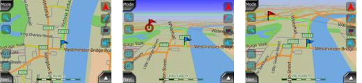
4.1.11Elements of the Active Route
AVIC-S2 uses a multi-destination routing system in which you have a start point (your current location if GPS position is available), a destination, the line of the active leg of the route, and optionally via points and inactive legs. They are all shown on the map.
4.1.11.1 The start point, via points and the destination
These points are represented by flags.
4.1.11.2Animated turn guidance
Animated arrows represent all route events other than the above-mentioned special points. These arrows show the direction in which you need to continue your journey.
21

4.1.11.3The active leg of the route
The active leg is the section of the route you are currently driving. If you have not added any Via points, the whole route will be the active leg. When Via points are present, the active leg is the part leading from your location to the next via point.
The active section is displayed in green. It is always the most conspicuous part of the map even when in the background of a 3D map view.
The line of the route is displayed on the driving side of the road for two-way and on the axis in case of one-way streets. When the map is zoomed in and the line is wide enough, small arrows show the direction of the route. This can be useful if you preview the route before starting the journey or when entering a complex junction.
4.1.11.4Inactive legs of the route
Future sections of a route are inactive. They are shown on the map in light blue. An inactive route section becomes active as soon as you reach its starting Via point.
22

4.1.11.5Roads in the route excluded by your preferences
Although you can choose whether to include or avoid some road types in Route parameter settings (Page 63), sometimes they are impossible to avoid near the starting point, via points or the destination.
If so, AVIC-S2 will display those segments of the route with an alternate colour.
4.2 GPS Data screen
Tap the small satellite icon on the Map or Cockpit screen to open this window.
The GPS Data screen is a collection of information received from the GPS device and it also serves as the entry point to the Time Sync screen.
4.2.1 GPS data displayed
The virtual sky on the left represents the currently visible part of the sky above you, with your position as the centre. The satellites are shown at their current positions.
The GPS receives data from both the green and grey satellites. Signals from the grey satellites are only received, while green ones are used by the GPS to calculate your current location. On the right you can see the satellite signal strength bars. Dark bars are for the grey and orange bars are for the green satellites. To identify satellites use their numbers also shown in the virtual sky. The more satellites your
GPS tracks (the green ones), the better your calculated position will be.
Additional pieces of information on this screen are: current position in latitude/longitude format, elevation, speed, date, time and calculated accuracy.
Note: Accuracy can be affected by several factors the GPS cannot take into account.
Use this accuracy information only as estimation.
There are two icons on the left to show the status of the GPS connection and the quality of reception.
23

4.2.2 GPS connection indicator
In the middle to the left there is a lamp similar to the ones used for switches. This one has more colours and represents more values:
• a fast blinking green lamp means that there is communication with the GPS and data is being received,
•
 other colours may not appear with a built-in GPS. Should any of these appear, this means a faulty operation of your device.
4.2.3GPS data quality indicator
In the top left corner there is a satellite dish to show the quality of the GPS position.
Different colours represent different signal quality:
• black with a red cross means there is no connection with the GPS device.
• red means the GPS is connected but no GPS position is available,
• yellow means 2D reception. A GPS position has been acquired, AVIC-S2 is ready for navigation, but the GPS is using enough satellites for calculating the horizontal position only. Elevation data is not provided, and the position error may be significant.
• green means 3D reception. The GPS receiver has enough satellites to calculate altitude. Position is generally correct (yet it can still be inaccurate due to different environmental factors). AVIC-S2 is ready for navigation.
4.2.4Time synchronization
In the top right corner of the screen you have another button that leads to a new screen where you can synchronize the clock of your AVIC-S2 to the very accurate time provided by the connected GPS.
24

Turn on the Auto Correction switch to let AVIC-S2 frequently check and correct the internal clock with the GPS time.
Below that button you will see the current values of the GPS and the device clocks.
You can check here whether any correction is needed. Tap the |
button to |
manually synchronize the time. |
|
Below the AVIC-S2 time you have hour and minute controls to manually correct the time with or without a valid GPS time.
4.3 Screens with map
Having explained the contents of the map, the description of the other parts of the map screens follows. There are two map screens: the Map search screen and the Cockpit screen. The way they show the map is the same but their look and controls are optimised for different purposes.
The Map screen is to be used mainly without a GPS, to browse the map, create user POI items, or to plan your route based on map points. The Map search screen is designed to give you the maximum map area. This screen is usually used in 2D North-up mode.
The Cockpit screen is for driving purposes. Besides showing the map, it contains some additional travel information if you do not have a route entered (speed, current street your are driving in, speed limit for the current street), and some more route data if you are navigating (e.g. next street in your route, distance to travel, type of the next route event). This screen is typically used in 3D Track-up mode.
There are several controls that function in a similar fashion on the two screens. They are described on the following pages.
Map search screen contents:
25
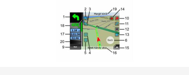
Cockpit screen contents:
No. Display
1(Cockpit only) Turn preview
2n/a
3n/a
4n/a
5n/a
6Indicates that Lock to GPS position and heading is inactive
7Selected map point (Cursor)
8(Map search only) Map scale
9n/a
10Map orientation and Overview
11GPS position quality
12Battery status
13Sound on or muted
14Track Log recording or playback
15n/a
16(Cockpit only) Current street
17(Cockpit only) Travel and Route data**
18(Cockpit only) Distance to next turn***
19(Cockpit only) Next street***
20(Cockpit only) Approaching next turn****
21n/a
Control
Opens Route menu
Zooms in (optional)
Zooms out (optional)
Tilts down (optional)
Tilts up (optional)
Re-enables Lock-to-Position / Smart Zoom
Opens Popup Info and Cursor menu Zooms in/out by dragging
Menu (Find, Quick, Route, Main)
Switches North-up, Track-up and Overview Opens GPS Data screen
Opens settings
Enables/disables muting
Opens Track Logs screen
Opens Cursor menu
Opens Route Information screen
Opens Route Information screen
n/a
n/a
n/a
(Map search only) Opens Cockpit screen
** Contents differ when a route is active
26
Loading...