


AVIC-HD3

Operation Manual
HDD AV NAVIGATION HEAD UNIT
AVIC-HD3

The screens shown in the examples may differ from the actual screens.
The actual screens may be changed without notice for performance and function
improvements.

Introduction
Manual Overview
This manual provides important information you need to make full use of your new navigation system.
The beginning sections outline the navigation system and describe its basic operation. The later sections describe the details of the navigation functions.
Chapters 9 to 13 describe how to operate the AV functions. Please read these chapters when you use a
disc in the built-in DVD drive or operate the Pioneer audio equipment connected to the navigation system.
How to use this manual
Be sure to read the following descriptions
Licence Agreement (Page 5 to 8)
This provides a licence agreement of this software. Be sure to read this before using the software.
About the Data for the Map Database (Page 8)
This provides the date when the Map Database was recorded.
Copyright (Page 9)
This provides the copyright of the Map Database.
About Gracenote
This provides a licence agreement and copyright of the Gracenote
to read this before using this navigation system.
®
(Page 9)
®
music recognition service. Be sure
Finding the operation procedure from what you want to do
When you have decided what you want to do, you can find the page you need from the “Table of Contents”.
Finding the operation procedure from a menu name
If you want to check the meaning of each item displayed on the screen, you will find the necessary page
from the “Display Information” at the end of the manual.
Glossary
See the glossary to find the meaning of a term.
Index
The section at the end of this manual provides an index. See each term to find the main pages where it
is stated.
1

Overview for each chapter
Before Using the System
For safety reasons, it is particularly important that you fully understand your naviga-
1
2
3
4
5
6
tion system before using it. Be sure to read this chapter.
Basic Operation
Please read this section if you want to operate the navigation system immediately.
It will explain the basics of this system.
This section describes the basic operations for navigation.
How to Read the Map Display
This section describes how to read the map screen, and the method of changing map view or
map scale.
Modifying Map Configurations
The behaviour of your navigation system depends on the map display and guidance settings.
If you need to change any of the current settings, read the relevant section of this chapter.
Setting a Route to Your Destination
This section describes various ways to search for a destination, edit the current route conditions and operate the route during route guidance.
Registering and Editing Locations
You can register and edit the points on the map. This chapter describes how to register a
home location, favourite location or other location, and how to edit the entry in “Address
Book”.
7
8
9
10
2
Using Hands-free Phoning
When you are using a mobile phone featuring Bluetooth® technology by connecting the
Bluetooth (sold separately) unit to the navigation system, you can operate your mobile phone
hands-free. This chapter describes the operations related to hands-free phoning.
Modifying the General Settings for Navigation Functions
The behaviour of your navigation system depends a number of general settings for navigation functions. If you need to change any of the initial settings (default settings), read the relevant section of this chapter.
Using the AV Source (Built-in DVD Drive and Radio)
This section describes how to use DVD-Videos, CDs, MP3, discs and the radio.
Using the AV Source (Music Library)
You can record a music CD to the hard disk drive in the navigation system. This chapter
describes recording music and playing back the recorded music.

11
12
13
14
Using the AV Source (M-CD, iPod®, TV)
This chapter describes the audio source operations that can be used when Pioneer audio
equipment featuring IP-BUS (Multi-CD player, Interface adapter for iPod
nected.
Using the AV Source (AV, EXT, AUX)
This chapter describes the audio source operations that can be used when connecting AV
equipment with an RCA connector (AV input), future Pioneer devices (external unit), or auxiliary equipment (AUX).
Customising the Audio Setting related with Audio Visual
Using the audio source, various audio-visual settings are available to suit your tastes. This
chapter describes how to change the settings.
Operating Your Navigation System with Voice
This section describes navigation operations, such as searching the destination and performing audio operations by voice.
Appendix
Please read the appendix to learn more about your navigation system and information such
as the availability of after-care. Please see “Display Information” at the end of this manual
to check the details for each item on the menu.
®
, TV tuner) is con-
3

Terminology
Before moving on, take a few minutes to read the following information about the conventions used in
this manual. They will help you greatly as you learn how to use your new equipment.
• Hardware buttons on your navigation system are described in ALL CAPITAL, BOLD lettering:
e.g.)
MAP button, MENU button.
• Items in the different menus or touch keys available on the screen are described in brackets [ ] and
bold:
e.g.)
[Destination], [Settings].
• Extra information, alternative usages and other notes are presented like this:
e.g.)
❒ Touch keys which are not available at this time are greyed out.
• References to sections that describe information related to the current topics are indicated like this:
e.g.)
➲ Setting the Route Options ➞ Page 27
The tab on the right corner indicates which operation the description is related to: Navigation operation or AV (Audio Visual) source operation.
For example, “NAVI” indicates that the description is related to the operation for navigation control.
“NAVI/AV” indicates that the description is related to both operation for navigation
control and AV control.
About the definition of terminology
“Front Display” and “Rear Display”
In this manual, the screen that is attached to the body of this navigation unit will be referred to as the
“Front Display”. Any additional optional screen that is purchased for use in conjunction with this navigation unit will be referred to as the “Rear Display”.
“Video image”
“Video image” in this manual indicates the moving image from DVD-Video in the built-in DVD drive or
from the equipment that is connected to this system with an AV-BUS or RCA cable, such as a TV tuner
or general-purpose AV equipment.
Colour difference of the map display between day and night
Night display
The examples in this manual are illustrated using the daytime display. When driving at night, the colours you see may differ from those shown.
4

Licence Agreement
PIONEER AVIC-HD3
THIS IS A LEGAL AGREEMENT BETWEEN YOU,
AS THE END USER, AND PIONEER
CORP.(JAPAN) (“PIONEER”). PLEASE READ THE
TERMS AND CONDITIONS OF THIS AGREEMENT
CAREFULLY BEFORE USING THE SOFTWARE
INSTALLED ON THE PIONEER PRODUCTS. BY
USING THE SOFTWARE INSTALLED ON THE PIONEER PRODUCTS, YOU AGREE TO BE BOUND
BY THE TERMS OF THIS AGREEMENT. THE
SOFTWARE INCLUDES A DATABASE LICENCED
BY THIRD PARTY SUPPLIER(S) (“SUPPLIERS”),
AND YOUR USE OF THE DATABASE IS COVERED BY THE SUPPLIERS’ SEPARATE TERMS,
WHICH ARE ATTACHED TO THIS AGREEMENT
(Refer to page 7). IF YOU DO NOT AGREE WITH
ALL OF THESE TERMS, PLEASE RETURN THE
PIONEER PRODUCTS (INCLUDING THE SOFTWARE, AND ANY WRITTEN MATERIALS) WITHIN
FIVE (5) DAYS OF RECEIPT OF THE PRODUCTS,
TO THE AUTHORISED PIONEER DEALER FROM
WHICH YOU PURCHASED THEM.
1. GRANT OF LICENCE
Pioneer grants to you a non-transferable, nonexclusive licence to use the software installed on
the Pioneer products (the “Software”) and the
related documentation solely for your own personal use or for internal use by your business,
only on such Pioneer products.
You shall not copy, reverse engineer, translate,
port, modify or make derivative works of the Software. You shall not loan, rent, disclose, publish,
sell, assign, lease, sublicence, market or otherwise transfer the Software or use it in any manner
not expressly authorised by this agreement. You
shall not derive or attempt to derive the source
code or structure of all or any portion of the Software by reverse engineering, disassembly,
decompilation, or any other means. You shall not
use the Software to operate a service bureau or
for any other use involving the processing of data
for other persons or entities.
Pioneer and its licensor(s) shall retain all copyright, trade secret, patent and other proprietary
ownership rights in the Software. The Software is
copyrighted and may not be copied, even if modified or merged with other products. You shall not
alter or remove any copyright notice or proprietary legend contained in or on the Software.
You may transfer all of your licence rights in the
Software, the related documentation and a copy
of this Licence Agreement to another party, provided that the party reads and agrees to accept
the terms and conditions of this Licence Agreement.
2. DISCLAIMER OF WARRANTY
The Software and related documentation are provided to you “AS IS”. PIONEER AND ITS LICENSOR(S) (for the purpose of provisions 2 and 3,
Pioneer and its licensor(s) shall be collectively
referred to as “Pioneer”) MAKES AND YOU
RECEIVE NO WARRANTY, WHETHER EXPRESS
OR IMPLIED, AND ALL WARRANTIES OF MERCHANTABILITY AND FITNESS FOR ANY PARTICULAR PURPOSE ARE EXPRESSLY EXCLUDED.
SOME COUNTRIES DO NOT ALLOW EXCLUSION
OF IMPLIED WARRANTIES, SO THE ABOVE
EXCLUSION MAY NOT APPLY TO YOU. The Software is complex and may contain some non-conformities, defects or errors. Pioneer does not
warrant that the Software will meet your needs or
expectations, that operation of the Software will
be error free or uninterrupted, or that all non-conformities can or will be corrected. Furthermore,
Pioneer does not make any representations or
warranties regarding the use or results of the use
of the Software in terms of its accuracy, reliability
or otherwise.
5

3. LIMITATION OF LIABILITY
IN NO EVENT SHALL PIONEER BE LIABLE FOR
ANY DAMAGES, CLAIM OR LOSS INCURRED BY
YOU (INCLUDING, WITHOUT LIMITATION, COMPENSATORY, INCIDENTAL, INDIRECT, SPECIAL,
CONSEQUENTIAL, OR EXEMPLARY DAMAGES,
LOST PROFITS, LOST SALES OR BUSINESS,
EXPENDITURES, INVESTMENTS, OR COMMITMENTS IN CONNECTION WITH ANY BUSINESS,
LOSS OF ANY GOODWILL, OR DAMAGES)
RESULTING FROM THE USE OF OR INABILITY TO
USE THE SOFTWARE, EVEN IF PIONEER HAS
BEEN INFORMED OF, KNEW OF, OR SHOULD
HAVE KNOWN OF THE LIKELIHOOD OF SUCH
DAMAGES. THIS LIMITATION APPLIES TO ALL
CAUSES OF ACTION IN THE AGGREGATE,
INCLUDING WITHOUT LIMITATION BREACH OF
CONTRACT, BREACH OF WARRANTY, NEGLIGENCE, STRICT LIABILITY, MISREPRESENTATION, AND OTHER TORTS. IF PIONEER’S
WARRANTY DISCLAIMER OR LIMITATION OF
LIABILITY SET FORTH IN THIS AGREEMENT
SHALL OR FOR ANY REASON WHATSOEVER BE
HELD UNENFORCEABLE OR INAPPLICABLE,
YOU AGREE THAT PIONEER’S LIABILITY SHALL
NOT EXCEED FIFTY PERCENT (50%) OF THE
PRICE PAID BY YOU FOR THE ENCLOSED PIONEER PRODUCT.
Some countries do not allow the exclusion or limitation of incidental or consequential damages,
so the above limitation or exclusion may not
apply to you. This warranty disclaimer and limitation of liability shall not be applicable to the
extent that any provision of this warranty is prohibited by any country or local law which cannot
be preempted.
4. EXPORT LAW ASSURANCES
You agree and certify that neither the Software
nor any other technical data received from Pioneer, nor the direct product thereof, will be
exported outside the country or district (the
“Country”) governed by the government having
jurisdiction over you (the “Government”) except
as authorised and as permitted by the laws and
regulations of the Government. If the Software
has been rightfully obtained by you outside of the
Country, you agree that you will not re-export the
Software nor any other technical data received
from Pioneer, nor the direct product thereof,
except as permitted by the laws and regulations
of the Government and the laws and regulations
of the jurisdiction in which you obtained the Software.
5. TERMINATION
This Agreement is effective until terminated. You
may terminate it at any time by destroying the
Software. The Agreement also will terminate if
you do not comply with any terms or conditions of
this Agreement. Upon such termination, you
agree to destroy the Software.
6. MISCELLANEOUS
This is the entire Agreement between Pioneer
and you regarding its subject matter. No change
in this Agreement shall be effective unless
agreed to in writing by Pioneer. If any provision of
this Agreement is declared invalid or unenforceable, the remaining provisions of this Agreement
shall remain in full force and effect.
6

Whereis® Navigation DIGITAL
ROAD MAP DATA LICENCE
TERMS
This Licence relates only to the use of the
®
Whereis
not to the navigation system in which it is used.
IMPORTANT
To protect your own interests, please read these
terms and conditions carefully before you commence using the Pioneer In-Car Navigation System (“Navigation System”) containing the
Whereis
you are uncertain as to your rights and obligations under this Licence or you would like any
explanation about them please contact Sensis
Pty Ltd (ABN 30 007 423 912) (“Sensis”) on 1800
819 471. Your licence from Sensis to use the
Whereis
terms and conditions set out below. If you do not
agree to these terms and conditions, return this
package to your place of purchase or call 1800
819 471.
map navigation digital road data and
®
mapping data (“Whereis® Data”). If
®
Data (“Licence”) is subject to the
Sensis if you become aware of any of these
events occurring or of any other infringement
of Sensis’ rights in relation to the Whereis
Data.
3 PROPERTY AND OWNERSHIP
3.1 All intellectual property rights (including
copyright) in and to the Whereis
the sole and exclusive property of Sensis (or
its Licensors) and except for the rights
granted to you in this Licence, you will not
acquire any intellectual property or other
rights in or to the Whereis
of the Whereis
The Whereis
®
Data.
®
Data incorporates data which
is © Commonwealth of Australia (Geoscience
Australia) 2004. (This data has been used
with the permission of Geoscience Australia.
Geoscience Australia has not evaluated this
data as altered and incorporated within this
device and therefore gives no warranty
regarding its accuracy, completeness, currency or suitability for any particular purpose).
®
Data are
®
Data or any part
®
1 GRANT OF LICENCE
1.1 Telstra Corporation Limited (ABN 33 051 775
556) through its agent Sensis grants you a
non-exclusive, non-transferable licence (with
no rights to sub-licence) to use the Whereis
Data on the terms and conditions contained
in this Licence.
1.2 The Licence commences on the date you start
using the Navigation System and continues
until the Licence ends in accordance with the
terms and conditions set out below.
2RIGHTS OF USE
2.1 You may:
(a) use the Whereis
vehicle navigation system; and
(b) only use the Whereis
use.
2.2 You must not reproduce, reverse compile,
adapt, modify, assign, distribute or publish in
any form the whole or any part of the
®
Whereis
Data.
2.3 You must take all reasonable steps to prevent
any of the events in clause 2.2 occurring or
any unauthorised copying or use of the
®
Whereis
Data, and must immediately notify
®
Data on any compatible
®
Data for personal
Melbourne data includes information sourced
from the Department of Treasury and
Finance, Geographic Data Victoria.
®
4ACCURACY OF DATA
4.1 Sensis will use reasonable care and skill in
providing the Whereis
the Whereis
®
®
Data and will provide
Data to you in accordance with
this Licence. However, given the nature of
navigation systems (including the possibility
that a change in traffic conditions could
affect the accuracy of the Whereis
and the fact that Sensis must obtain some of
the Data from other sources, Sensis cannot
promise that the Whereis
®
Data will be error
free, complete or up to date.
5SENSIS’ LIABILITY TO YOU
5.1 The terms and conditions that apply to the
supply and use of the Whereis
those that are expressly set out in this
Licence and those implied by consumer protection laws to the supply and use of the
®
Whereis
excluded. No other terms apply.
Data that are unable to be
®
Data)
®
Data are
7

5.2 Subject to clause 5.3, Sensis accepts its liability to you for breach of these terms and conditions or negligence under the principles
applied by the courts.
5.3 The Whereis
®
Data is provided to you for the
primary purpose of personal, domestic or
household use, so Sensis does not accept liability to you for losses that result from the use
of the Whereis
®
Data in connection with the
conduct of a business. However, Sensis will
accept that liability if it cannot be excluded
under any legislation. Sensis is also not liable
for any loss to the extent that it is caused by
you, for example, through your negligence or
breach of these terms and conditions.
5.4 Sensis is not liable for failing to comply with
the terms and conditions applying to the
®
Whereis
by events outside Sensis’ reasonable control,
such as abuse or misuse of the Whereis
Data, damage to the Whereis
Data where that failure is caused
®
®
Data caused
by faults in equipment that is not owned by
Sensis, any accident by you or a third party
which damages the Whereis
unusual hazards affecting the Whereis
®
Data or any
®
Data
(including exposure to excessive humidity,
heat, cold, dust, food or liquids).
6 YOUR LIABILITY TO SENSIS
6.1 Subject to clause 6.2, you are liable to Sensis
for breach of these terms and conditions or
negligence under the principles applied by
the courts.
6.2 You are not liable for any loss to the extent
that it is caused by Sensis, for example,
through Sensis’ negligence or breach of
these terms and conditions.
cancellation, you must immediately cease
using the Whereis
®
Data.
Any rights or remedies which existed before
cancellation will continue to exist after cancellation.
8GENERAL
8.1 A provision of, or a right under, this Licence
may not be waived except in writing signed by
the party that is waiving the provision or right.
8.2 This Licence will be governed by the laws in
force in Victoria, Australia.
8.3 A reference to a person in this Licence
includes a reference to a firm, corporation or
other corporate body.
About the Data for the Map
Database
• This database was developed and recorded up
to November 2005. Changes to streets/roads
made after that time may not be reflected in
this database.
• It is strictly prohibited to reproduce and use
any part or the whole of this map in any form
without permission from the copyright owner.
• If the local traffic regulations or conditions
deviate from this data, follow the local traffic
regulations (such as signs, indications, etc.)
and conditions (such as construction, weather,
etc.).
• The traffic regulation data used in the map
database applies only to standard sized passenger vehicles. Note that regulations for
larger vehicles, motorbikes, and other nonstandard vehicles are not included in the database.
7 CANCELLING THE LICENCE
7.1 Sensis may cancel the Licence immediately
by giving you notice if you are in breach of
these terms and conditions.
7.2 Sensis may also cancel the Licence by giving
you as much notice as is reasonably possible
if:
(i) the law requires Sensis to do so; or
(ii) providing the Licence becomes illegal or
Sensis believes on reasonable grounds
that it may become illegal.
7.3 Your rights under this Licence will end as
soon as this Licence is cancelled. Following
8

Copyright
technology was used in
developing this product
®
& Whereis® are registered trademarks of
Sensis
Telstra Corporation Limited (ABN 33 051 775 556).
®
& Gregory’s® are registered trademarks of
UBD
Universal Publishers Pty. Ltd.
© Telstra Corporation Limited 2006. SEN0236
July 2006
© 2007 INCREMENT P CORP. ALL RIGHTS
RESERVED
About Gracenote
Music recognition technology and related data are provided by Gracenote
in music recognition technology and related content
delivery. For more information, please visit
www.gracenote.com.
CD and music-related data from Gracenote, Inc., copyright © 2006 Gracenote. Gracenote Software, copyright
© 2006 Gracenote.
This product and service may practice one or more of the
following U.S. Patents: #5,987,525; #6,061,680;
#6,154,773, #6,161,132, #6,230,192, #6,230,207,
#6,240,459, #6,330,593, and other patents issued or
pending. Some services supplied under licence from
Open Globe, Inc. for U.S. Patent: #6,304,523.
Gracenote and CDDB are registered trademarks of
Gracenote. The Gracenote logo and logotype, and the
"Powered by Gracenote" logo are trademarks of
Gracenote.
®
®
. Gracenote is the industry standard
Gracenote® End User Licence
Agreement
This application or device contains software from
Gracenote, Inc. of Emeryville, California (“Gracenote”).
The software from Gracenote (the “Gracenote Software”)
enables this application to perform disc and/or file identification and obtain music-related information, including name, artist, track, and title information (“Gracenote
Data”) from online servers or embedded databases (collectively, “Gracenote Servers”) and to perform other
functions. You may use Gracenote Data only by means of
the intended End-User functions of this application or
device.
You agree that you will use Gracenote Data, the
Gracenote Software, and Gracenote Servers for your own
personal non-commercial use only. You agree not to
assign, copy, transfer or transmit the Gracenote Software or any Gracenote Data to any third party. YOU
AGREE NOT TO USE OR EXPLOIT GRACENOTE DATA,
THE GRACENOTE SOFTWARE, OR GRACENOTE SERVERS, EXCEPT AS EXPRESSLY PERMITTED HEREIN.
You agree that your non-exclusive licence to use the
Gracenote Data, the Gracenote Software, and Gracenote
Servers will terminate if you violate these restrictions. If
your licence terminates, you agree to cease any and all
use of the Gracenote Data, the Gracenote Software, and
Gracenote Servers. Gracenote reserves all rights in
Gracenote Data, the Gracenote Software, and the
Gracenote Servers, including all ownership rights. Under
no circumstances will Gracenote become liable for any
payment to you for any information that you provide. You
agree that Gracenote, Inc. may enforce its rights under
this Agreement against you directly in its own name.
The Gracenote service uses a unique identifier to track
queries for statistical purposes. The purpose of a randomly assigned numeric identifier is to allow the
Gracenote service to count queries without knowing anything about who you are. For more information, see the
web page for the Gracenote Privacy Policy
Gracenote service.
The Gracenote Software and each item of Gracenote
Data are licenced to you “AS IS.” Gracenote makes no
representations or warranties, express or implied,
regarding the accuracy of any Gracenote Data from in
the Gracenote Servers. Gracenote reserves the right to
delete data from the Gracenote Servers or to change
data categories for any cause that Gracenote deems sufficient. No warranty is made that the Gracenote Software
or Gracenote Servers are error-free or that functioning of
Gracenote Software or Gracenote Servers will be uninterrupted. Gracenote is not obligated to provide you with
new enhanced or additional data types or categories that
Gracenote may provide in the future and is free to discontinue its services at any time.
GRACENOTE DISCLAIMS ALL WARRANTIES EXPRESS
OR IMPLIED, INCLUDING, BUT NOT LIMITED TO,
IMPLIED WARRANTIES OF MERCHANTABILITY, FITNESS FOR A PARTICULAR PURPOSE, TITLE, AND NONINFRINGEMENT. GRACENOTE DOES NOT WARRANT
THE RESULTS THAT WILL BE OBTAINED BY YOUR USE
OF THE GRACENOTE SOFTWARE OR ANY GRACENOTE
SERVER. IN NO CASE WILL GRACENOTE BE LIABLE
FOR ANY CONSEQUENTIAL OR INCIDENTAL DAMAGES
OR FOR ANY LOST PROFITS OR LOST REVENUES.
© Gracenote 2006 Version 20061005
for the
9

Other Precautions
• Part of the data cannot be acquired. The con-
tents of the data in the Gracenote
included in the hard disk drive are not 100%
guaranteed.
•The Gracenote
®
Database included in the hard
disk drive contains the titles for the 300 000
most frequently accessed albums worldwide
as of November 2006.
®
Database
10

Table of Contents
Introduction
Manual Overview 1
How to use this manual 1
Overview for each chapter 2
Terminology 4
About the definition of terminology 4
Colour difference of the map display between
day and night 4
Licence Agreement 5
PIONEER AVIC-HD3 5
Whereis® Navigation DIGITAL ROAD MAP
DATA LICENCE TERMS 7
About the Data for the Map Database 8
Copyright 9
About Gracenote® 9
Gracenote® End User Licence Agreement 9
Other Precautions 10
Table of Contents 11
Chapter 1
Before Using the System
Important Safety Information 15
Additional Safety Information 16
To ensure safe driving 16
Features (Characteristics of this software) 17
Notes for Hard Disk Drive 17
Recording equipment and copyright 17
Notes when writing data to the hard disk drive at
low temperature 17
Points about recording 18
Data saved or recorded by the customer 18
In Case of Trouble 18
Chapter 2
Basic Operation
Flow from Startup to Termination 19
How to Use Navigation Menu Screens 20
Displaying the Navigation menu 20
Navigation menu overview 20
Basic Navigation 21
Calculating your destination by using Address
Search 22
Checking and modifying the route 25
When the route guidance starts 26
Cancelling the Route Guidance 26
Modifying the Route Calculation Conditions 27
Items that users can operate 27
Checking the Current Route 28
Checking the passing streets with a list 28
Checking the entire route overview on the
map 28
Editing Waypoints 29
Adding a waypoint 29
Deleting a waypoint 29
Sorting waypoints 30
Skipping a waypoint 30
Chapter 3
How to Read the Map Display
How to Use the Map 31
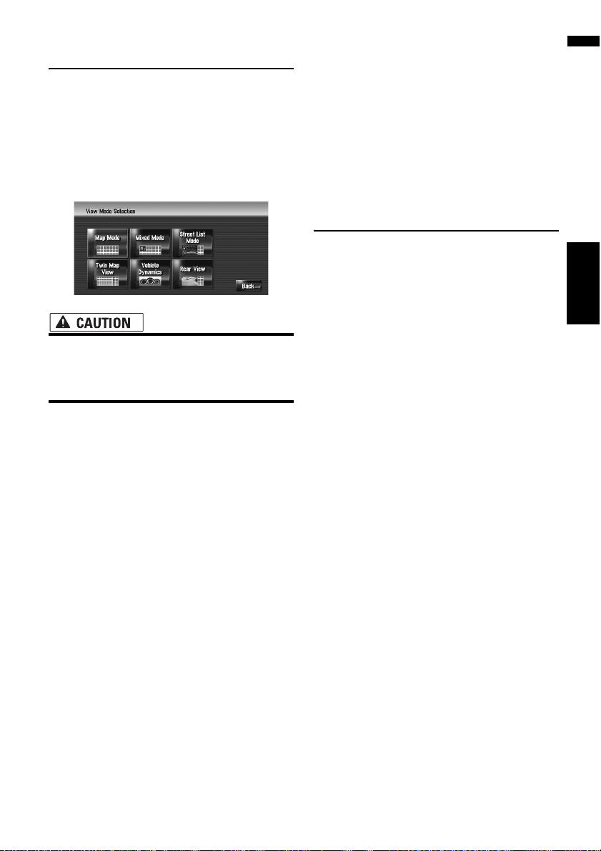
Switching the view mode 31
How to view the map of the current location 31
Changing the scale of the map 35
Scroll the map to the location you want to
see 35
Shortcut menu 36
Setting the Vehicle Dynamics Display 37
Chapter 4
Modifying Map Configurations
Entering the Map Menu 39
Setting the Item on the Map Screen 39
Selecting the Shortcut 40
Displaying POI on the Map 41
Viewing the Map Colour Legend 41
Changing the View Mode for the Navigation
Map 42
Setting the Map Colour Change between Day and
Night 42
Changing the Setting of Navigation Interruption
Screen 42
Changing the Map Colour 42
Chapter 5
Setting a Route to Your Destination
Searching for Points of Interest (POI)
Countrywide 43
Searching for a POI directly from the name of
the facilities 43
Searching for POIs by specifying a category
first 44
Searching for POIs by specifying a city name
first 45
Finding a POI in the Vicinity 45
Searching for the facilities around the current
position 45
Searching for the facilities around the scroll
cursor 46
Route Calculation to Your Home Location or to
Your Favourite Location 47
Selecting Destination from the Destination Histo-
ry and Address Book 47
11

Registering/deleting POI Shortcuts 48
Registering a POI shortcut 48
Deleting a POI shortcut 48
Chapter 6
Registering and Editing Locations
Registering Locations Overview 49
Registering Your Home and Your Favourite
Location 49
Registering a Location into Address Book 50
Registering a location by scroll mode 50
Registering a location by Address Book 50
Viewing the Address Book 51
Editing the entry in “Address Book” 51
Deleting the entry in “Address Book” 54
Destination History Operations 55
Deleting the entry in “Destination History” 55
Chapter 7
Using Hands-free Phoning
Hands-free Phoning Overview 57
Preparing communication devices 57
Setting up for hands-free phoning 58
Receiving a phone call 60
Making a phone call 60
Transferring the phone book 63
Registering a phone number in “Dial
Favourites” 63
Editing the entry in “Phone Book” 64
Editing the received call or dialled number
history 65
Chapter 8
Modifying the General Settings for
Navigation Functions
Entering the Settings Menu 67
Setting the Volume for Guidance and Phone 67
Customising the Regional Settings 67
Setting the time difference 67
Setting the keyboard layout 68
Changing the unit between km and miles 68
Changing the virtual speed of the vehicle 68
Checking the Setting Related with Hardware 69
Checking the connections of leads and installa-
tion positions 69
Checking sensor learning status and driving
status 70
Correcting the installation angle 70
Checking the device and version
information 71
Checking the hard disk information 71
Registering the Home Location and Favourite
Location 71
Changing the Background Picture 72
Using the Demonstration Guidance 73
Correcting the Current Location 73
Restoring the Default Setting 73
Chapter 9
Using the AV Source (Built-in DVD
Drive and Radio)
Basic Operation 75
Switching the Audio operation screen 75
Selecting a source 75
About Steering Remote Control 76
Viewing the audio operation screen and display-
ing the Audio Settings menu 77
Operating a Music CD 78
Selecting [CD] as the source 78
About auto hard disk recording 78
Screen configuration 78
Touch key operation 79
Operating the CD-ROM (MP3 disc) 80
Selecting [ROM] as the source 80
Screen configuration 80
Touch key operation 80
Notes on playing MP3 disc 82
Operating the DVD 82
Selecting [DVD] as the source 82
Screen configuration 82
Touch key operation 83
Searching for a desired scene, starting play-
back from a specified time 84
Entering the numerical commands 85
Operating the Radio (FM) 85
Selecting [FM] as the source 85
Screen configuration 85
Touch key operation 86
Storing the strongest broadcast frequencies 86
Tuning in strong signals 86
Operating the Radio (AM) 87
Selecting [AM] as the source 87
Screen configuration 87
Touch key operation 87
Storing the strongest broadcast frequencies 88
Tuning in strong signals 88
Chapter 10
Using the AV Source (Music Library)
Music Library Recording 89
Recording all tracks in a CD 90
Recording a CD manually 90
Recording only the first track of a CD 90
12

Stopping CD recording 90
Notes on CD recording 91
Music Library Play 91
Selecting [LIBRARY] as the source 91
Screen configuration 91
Touch key operation 92
Creating a playlist with a customised order 94
Editing a playlist or tracks 95
Assigning another candidate for title
information 100
Chapter 11
Using the AV Source (M-CD, iPod®,
TV)
Operating the Multi-CD Player 101
Selecting [M-CD] as the source 101
Screen configuration 101
Touch key operation 101
Operating the iPod® 103
Selecting [iPod] as the source 103
Screen configuration 103
Touch key operation 103
Browsing for a song 104
Operating the TV tuner 105
Selecting [TV] as the source 105
Screen configuration 105
Touch key operation 105
Storing and recalling broadcast stations 106
Storing the strongest broadcast stations
sequentially 106
Selecting the country group 106
Chapter 12
Using the AV Source (AV, EXT,
AUX)
Operating the AV Input source (AV) 107
Selecting [AV INPUT] as the source 107
Operating the External Unit (EXT) 107
Selecting [EXT 1] or [EXT 2] as the source 107
Screen configuration 107
Touch key operation 108
Operate the external unit by using 1 key — 6
key 108
Operate the external unit by using Function 1 —
Function 4 108
Switching the automatic and manual
function 109
Operating the AUX input source (AUX) 109
Selecting [AUX] as the source 109
Chapter 13
Customising the Audio Setting related with Audio Visual
AV Setting Overview 111
How to Operate the Audio Settings screen 111
Customising the Audio Settings Items 111
Using the equaliser 111
Setting the simulated sound stage 113
Using balance adjustment 113
Using subwoofer output 114
Using non fading output 114
Adjusting loudness 114
Using the high pass filter 114
Adjusting source levels 115
Customising the System Settings Items 115
How to view and operate the System
Settings 115
Setting up the built-in DVD drive 116
Changing the wide screen mode 117
Setting for rear view camera 118
Setting the video input 118
Switching the auxiliary setting 119
Switching the muting/attenuation timing 119
Switching the muting/attenuation level 119
Changing the voice output of the navigation
guidance 120
Switching the auto aerial setting 120
Setting the clock display on the video
image 120
Setting the CD recording mode 120
Setting the rear output and subwoofer
controller 120
Other Functions 121
Selecting the video for “Rear display” 121
Operating the picture adjustment 122
Switching the backlight on or off 122
Language Code Chart for DVD 123
Chapter 14
Operating Your Navigation System
with Voice
To Ensure Safe Driving 125
Basics of Voice Operation 125
Flow of voice operation 125
To start voice operation 126
Tips for Voice Operation 127
An Example of Voice Operation 127
Search for POI in vicinity 127
Search for the playlist 128
Available Voice Commands 129
Basic commands for voice operation 129
Voice commands related to navigation 130
Voice commands related to hands-free
phoning 131
13

Voice commands related to AV operation 132
Location screen (A) and (B) 133
Other Voice Commands 134
Other voice commands for navigation
operation 134
Other voice commands for AV operation 136
Category list for vicinity search 137
Appendix
Returning the Navigation System to the Default or
Factory Settings 139
Setting items to be deleted 140
If system errors frequently occur 141
Completely returning the navigation system to
the initial state 141
Adjusting the Response Positions of the Touch
Panels (Touch Panel Calibration) 142
Positioning Technology 143
Positioning by GPS 143
Positioning by dead reckoning 143
How do GPS and dead reckoning work
together? 144
Handling Large Errors 145
When the positioning by GPS is impossible 145
Vehicles that Cannot Obtain Speed Pulse
Data 145
Conditions Likely to Cause Noticeable Positioning
Errors 145
Troubleshooting 148
Problems in the screen 148
Messages and How to React to Them 152
Messages for navigation functions 152
Messages for Audio Functions 156
Built-in DVD drive 156
Hard disk drive (Music Library) 156
Other sources 157
When the Hard Disk Drive is Disconnected 158
Route Setting Information 158
Route search specifications 158
Route highlighting 159
Tracking 159
Displaying POI 159
Detail Information for Playable Media 159
DVD discs and other DVD media types 159
AVCHD recorded discs 160
About playing Dual Disc 160
CD-R/CD-RW discs 160
MP3 files 160
Glossary 162
Display Information 165
Navigation menu 165
Shortcut menu 168
Menu in the Audio Screen 169
[Audio Settings] menu 169
[System Settings] menu (Page 1) 169
[System Settings] menu (Page 2) 169
Index 170
14

Before Using the System
Chapter 1
Important Safety Information
Before using your navigation system, be sure to
read and fully understand the following safety
information:
• Do not attempt to install or service your
navigation system by yourself. Installation
or servicing of the navigation system by
persons without training and experience in
electronic equipment and automotive
accessories may be dangerous and could
expose you to the risk of electric shock or
other hazards.
• When a route is calculated, the route and
voice guidance for the route is automatically set. Also, for day or time traffic regulations, only information about traffic
regulations at the time when the route was
calculated is shown. One-way streets and
street closures may not be taken into consideration. For example, if a street is open
during the morning only, but you arrive
later, it would be against the traffic regulations so you cannot drive along the set
route. When driving, please follow the
actual traffic signs. Also, the system may
not know some traffic regulations.
❒ Read the entire manual before operating this
navigation system.
❒ The navigation features of your navigation sys-
tem (and rear view camera option if purchased) are intended solely as an aid to you in
the operation of your vehicle. It is not a substitute for your attentiveness, judgement, and
care when driving.
❒ Do not operate this navigation system (or the
rear view camera option if purchased) if doing
so will divert your attention in any way from
the safe operation of your vehicle. Always
observe safe driving rules and follow all existing traffic regulations. If you experience difficulty in operating the system or reading the
display, park your vehicle in a safe location
and apply the handbrake before making the
necessary adjustments.
❒ Never allow others to use the system unless
they have read and understood the operating
instructions.
❒ Never use this navigation system to route to
hospitals, police stations or similar facilities in
an emergency. Stop using any functions relating to the hands-free phone and please call
the appropriate emergency number.
❒ Route and guidance information displayed by
this equipment is for reference purposes only.
It may not accurately reflect the latest permissible routes, road conditions, one way streets,
road closures, or traffic restrictions.
❒ Traffic restrictions and advisories currently in
force should always take precedence over
guidance given by the navigation system.
Always obey current traffic restrictions, even if
the navigation system provides contrary
advice.
❒ Failure to set correct information about the
local time may result in the navigation system
providing improper routing and guidance
instructions.
❒ Never set the volume of your navigation sys-
tem so high that you cannot hear outside traffic and emergency vehicles.
❒ To promote safety, certain functions are disa-
bled unless the vehicle is stopped and/or the
handbrake is applied.
❒ The data encoded in the hard disk drive for the
navigation system is the intellectual property
of the provider, and the provider is responsible
for such content.
Chapter 1 Before Using the SystemNAVI/AV
15

❒ Keep this manual handy as a reference for
operating procedures and safety information.
❒ Pay close attention to all warnings in this
manual and follow the instructions carefully.
❒ Do not install this navigation system where it
may (i) obstruct the driver’s vision, (ii) impair
the performance of any of the vehicle’s operating systems or safety features, including air
bags or hazard lamp buttons or (iii) impair the
driver’s ability to safely operate the vehicle.
❒ Please remember to wear your seat belt at all
times while operating your vehicle. If you are
ever in an accident, your injuries can be considerably more severe if your seat belt is not
properly buckled.
❒ Never use headphones while driving.
Chapter 1Before Using the System NAVI/AV
Additional Safety Information
To ensure safe driving
Handbrake interlock
Certain functions (such as viewing of DVD video
and certain touch key operations) offered by this
navigation system could be dangerous and/or
unlawful if used while driving. To prevent such
functions from being used while the vehicle is in
motion, there is an interlock system that senses
when the handbrake is set and when the vehicle
is moving. If you attempt to use the functions
described above while driving, they will become
disabled until you stop the vehicle in a safe place,
and apply the handbrake. Please keep the brake
pedal pushed down before releasing the handbrake.
• When applying the handbrake in order to
view “Video image” or to enable other
functions offered by the navigation system, park your vehicle in a safe place, and
keep the brake pedal pushed down before
releasing the handbrake if the vehicle is
parked on a hill or otherwise might move
when releasing the handbrake.
When you attempt to watch “Video image” while
driving, the warning “Viewing of front seat
video source while driving is strictly prohibited.” will appear on the screen. To watch “Video
image” on this display, stop the vehicle in a safe
place and apply the handbrake. Please keep the
brake pedal pushed down before releasing the
handbrake.
Rear view camera and [Rear View]
mode
With an optional rear view camera, you are able
to use the navigation system as an aid to keep an
eye on trailers or to back into a tight parking spot.
• SCREEN IMAGE MAY APPEAR
REVERSED.
• USE INPUT ONLY FOR REVERSE OR
MIRROR IMAGE REAR VIEW CAMERA.
OTHER USE MAY RESULT IN INJURY
OR DAMAGE.
• To avoid the risk of damage and injury and
the potential violation of applicable laws,
the navigation system is not for use with a
“Video image” that is visible to the driver.
• In some countries the viewing of “Video
image” on a display inside a vehicle even
by persons other than the driver may be
illegal. Where such regulations apply, they
must be obeyed.
16
Features (Characteristics of this
software)
Touch panel key operation
It is possible to operate the navigation functions
and the Audio functions by using touch panel
keys.
Variety of view modes
Various types of screen display can be selected
for navigation guidance.
Compatible voice recognition system
Connecting the supplied microphone will enable
voice operation for both the navigation and AV
functions.
Original image assignment
You can store your own pictures on a CD-R in
JPEG format and import original images in this
navigation system. These imported images can
be set as a background or as a picture in an
address book or phone book entry.
Notes for Hard Disk Drive
• The rear view mode is to use the navigation system as an aid to keep an eye on the
trailers, or while backing up. Do not use
this function for entertainment purposes.
Wide variety of facility information for
Points of Interest (POI) search
You can search for your destination from a wide
area.
– Approximately 186 thousand POIs are included
in the database.
– Some POI information may not be accurate or
may become inaccurate through the passage of
time. Please contact the POI directly to verify the
accuracy of the information about the POI that
appears in this database. POI information is subject to change without notice.
Auto reroute function
If you deviate from the set route, the system will
re-calculate the route from that point so that you
remain on track to the destination.
❒ This function may not work in certain areas.
Recording equipment and copyright
Recording equipment should be used only for
lawful copying and you are advised to check carefully what defines lawful copying in the country in
which you are making a copy. Copying of copyright material such as films or music is unlawful
unless permitted by a legal exception or consented to by the right owners.
Notes when writing data to the
hard disk drive at low temperature
Writing to the hard disk drive, such as recording
music to the Music Library, may be disabled
when the navigation system detects abnormally
low temperatures inside the vehicle. Functionality
will become available once the temperature
inside the vehicle returns to normal. Additionally,
if the low temperature continues for a long time,
the system may be booted up with the preliminary mode because the system can not recognise
the hard disk drive.
➲ “When the Hard Disk Drive is Disconnected”
➞ Page 158
Chapter 1 Before Using the SystemNAVI/AV
Auto CD title and MP3 file listing
Title lists are automatically displayed when a CD
or MP3 disc is played. This system provides easyto-operate audio functions that allow playback
simply by selecting an item from the list.
17

Points about recording
❒ Pioneer does not compensate for the contents
that could not be recorded or any loss of
recorded data due to a malfunction or failure
of the navigation system.
❒ The data recorded on the navigation system is
not allowed to be used without permission
from its right holder under copyright law,
except for personal entertainment.
❒ Make sure to check the recording operation
before recording and check the recorded contents after recording.
❒ Recording is not guaranteed for all CDs.
Data saved or recorded by the
customer
Chapter 1Before Using the System NAVI/AV
❒ The data saved or recorded onto this naviga-
tion system by the customer cannot be
extracted from the navigation system, and
those services cannot be accepted.
❒ The data saved or recorded onto this naviga-
tion system by the customer cannot be guaranteed during repair or service. Lost data that
was saved or recorded by the customer is not
guaranteed.
❒ Due to copyrights, the music data recorded
into the Music Library cannot be backed up
during repair or service.
In Case of Trouble
Should the navigation system fail to operate properly, contact your dealer or nearest authorised
Pioneer Service Station.
18

Basic Operation
Chapter 2
NAVI Chapter 2 Basic Operation
Flow from Startup to Termination
At first, please confirm the positions of the following features using the “Hardware Manual”.
• MAP button
• MENU button
• AV button
• OPEN CLOSE button
1 Start the engine to boot up the system.
After a short pause, the navigation splash
screen comes on for a few seconds.
When you use the navigation system for the first
time, the [Regional Settings] screen appears.
On the [Regional Settings] screen, you can
change the time. (The settings can also be
changed afterward.)
➲ “Customising the Regional Settings” ➞
Page 67
2 Check the details of the caution message
and touch [OK].
You can operate the navigation system by
touching keys displayed on the screen.
The map of your surroundings is displayed.
If the route is already set, the screen changes
to route guidance mode.
➲ How to read the current position screen ➞
Page 31
➲ “Setting the time difference” ➞ Page 67
❒ To protect the LCD screen from damage,
be sure to touch the touch keys with a finger. (The stylus is supplied for special calibrations. Do not use the stylus for normal
operations.)
4 Assign a destination by using the touch
panel key and beginning route guidance,
or operating the Audio source.
❒ Touch keys that are not available at this
time are inactive.
➲ Specifying the address and searching the
destination ➞ Page 22
➲ Searching the destination by map ➞
Page 36
➲ Other search methods ➞ Page 43 to 47
➲ How to use audio source ➞ Page 75 to 123
5 Turn off the vehicle engine to terminate
the system.
The navigation system is also turned off.
❒ Until your vehicle reaches the vicinity of
the destination, the set route will not be
deleted even if the engine is turned off.
3 Press the MENU button.
This displays the navigation menu.
19
How to Use Navigation Menu
Screens
The basic navigation is performed by using
menus.
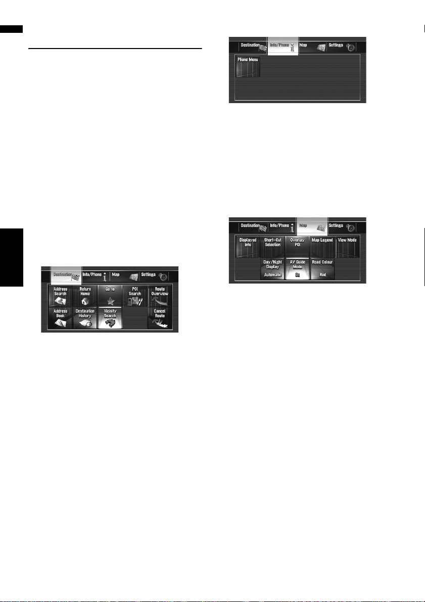
The navigation menu is divided into four menus:
[Destination], [Info/Phone], [Map], and
[Settings].
Displaying the Navigation menu
1 Press the MENU button.
2 To change to the menu you want to use,
touch the name of the menu displayed at
the top of the screen.
3 If you want to return to the map, press the
MENU button.
Navigation menu overview
[Destination] menu
Chapter 2Basic Operation NAVI
You can search your destination in this menu.
You can also check or cancel your set route from
this menu.
➲ Specifying the address and searching for the
destination ➞ Page 22
➲ Other search methods ➞ Page 43 to 47
[Info/Phone] menu
If you are using a mobile phone featuring Bluetooth technology by connecting the Bluetooth
unit (ND-BT1) (sold separately) to the navigation
system, you can configure Bluetooth settings or
check the outgoing/incoming call history.
❒ [Phone Menu] is active only when the Blue-
tooth unit (ND-BT1) is connected to the navigation system.
[Map] menu
You can change the [View Mode], or set the
items to be displayed during the navigation function.
❒ [View Mode] can be selected only when the
vehicle position is at the current position. If
you want to select [View Mode] while scrolling the map, press the MAP button to centre
the current position back on the vehicle position.
20
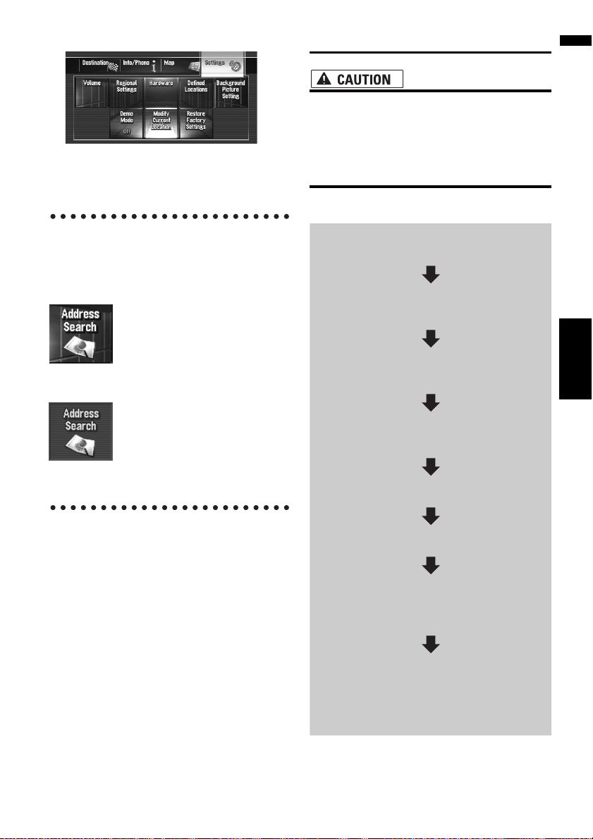
[Settings] menu
Customise the navigation functions so they can
be used easily.
➲ Settings menu ➞ Chapter 8
Buttons you can use
The availability of a specific button or function is
indicated by its appearance. Depending on the
status of your vehicle, some buttons will be available, while others will not be.
Basic Navigation
• For safety reasons, you cannot use some of
these basic navigation functions while
your vehicle is in motion. To enable these
functions, you must stop in a safe place
and apply the handbrake (see page 16 for
details).
Basic flow of operation
1 Park your vehicle in a safe place and
apply the handbrake.
2 Press the MENU button to display the
navigation menu.
Chapter 2 Basic OperationNAVI
Active touch key: The button is operable.
Inactive touch key: The function is not available
(e.g. operation is prohibited while driving).
3 Select the method of searching for your
destination.
4 Enter the information about your desti-
nation to calculate route.
5 Confirm the location on the map.
6 Check and decide the route.
7 Your navigation system sets the route to
your destination, and the map of your
surroundings appears.
8 After releasing the handbrake, drive in
accordance with the navigation information, subject to the important safety
instructions noted on pages 15 and 16.
21
Calculating your destination by
using Address Search
The most frequently used function is [Address
Search], in which the address is specified and
the destination is searched. This section
describes how to use [Address Search] and the
basics of using the navigation system.
1 Press the MENU button to display the
navigation menu.
2 Touch [Destination] in the navigation
menu.
3 Touch [Address Search].
Select the method for searching the destination.
Chapter 2Basic Operation NAVI
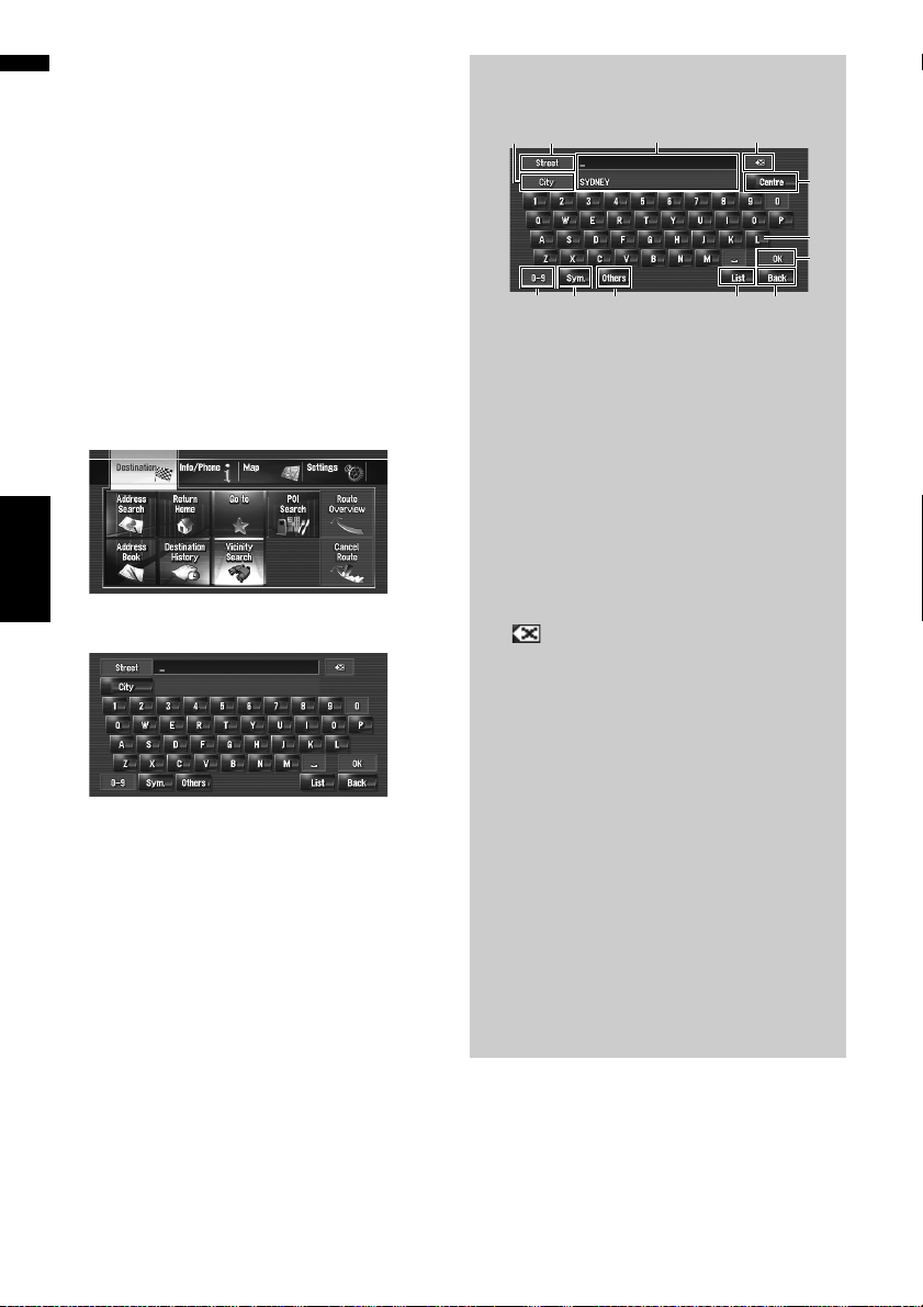
4 Input the street name.
When the options are narrowed down to six or
less, a list of the matching streets automatically appears.
When you enter the same characters that
were entered previously, the system automatically displays the characters that follow the
entered characters. (Auto fill-in function)
❒ When entering the characters, the system
will automatically search the database for
all possible options. If there is only one letter that could possibly follow your entry,
that letter will automatically be entered.
❒ A list appears if multiple options exist.
Select the desired one from the list and
proceed to the next step. In rare cases, you
may need to input the city name to determine the city.
Operation of street name or city name
input screen (e.g. QWERTY keyboard)
(7)
(11)
(10)
(9)
(1) [OK]:
Confirms the characters displayed in (3), and
proceeds to the next step.
(2) [List]:
Lists candidates based on yellow characters
in (3). Touch the desired item in the list to proceed to the next step.
(3) Text box:
Displays the characters that are entered.
(4) Keyboard:
Use to enter the text.
(5) [Back]:
Returns previous screen.
(6) :
Deletes the input text one letter at a time from
the end of the text. Continuing to touch the
button deletes all of the text.
(7) [City]:
Touch if you want to specify the destination
city or area first. (This is available only when
street name is blank.)
(8) [Others]:
You can enter other characters of alphabet.
❒ When you use any of “A”, “Ä”, “Å”, “Æ”,
the displayed result is the same.
(9) [Sym.]:
You can input text with marks such as [&] or
[+].
(10) [0-9]:
You can input text with numbers.
(3) (6)
(8)
(12)
(4)
(1)
(2) (5)
22

(11) [Street]:
Touch if you want to return the street input
mode. (This is available only when city name
is blank.)
(12) [Centre]:
This can be selected when you enter a city or
area name first. Touch this button to display
the central point of the entered city or area.
Touching [OK] searches the route to the central point. Proceed to Step 8.
❒ You can customise the keyboard type to be
displayed on the screen.
➲ “Setting the keyboard layout” ➞ Page 68
5 Touch the street from the list.
If the selected street has only one matching
location, “Route confirmation screen”
appears. Proceed to Step 8.
6 Touch the city or area where your destina-
tion is located.
Auto fill-in function
The previously entered characters are stored
for each search function. The next time a
character is entered, suggested characters
will be shown. For example, if [GEORGE
STREET] has been entered in the past, when
you input just the letter [G], [GEORGE
STREET] will be filled in automatically. The
manually input characters are displayed in
yellow, and the suggested characters are displayed in white, so you can distinguish them.
To confirm the filled-in characters, touch
[OK].
Chapter 2 Basic OperationNAVI
7 Input the house number and touch [OK].
Touch the characters you want to input.
When a route is not set, route calculation
starts immediately.
➲ “Checking and modifying the route” ➞
Page 25
When a route is already set, “Location confirmation screen” is shown.
➲ “Checking the location on the map” ➞
Page 24
❒ If you touch [OK] with no input, the central
point of the house number range is dis-
played and “Location confirmation screen”
appears.
23
Route calculation starts.
When the route calculation is completed,
“Route confirmation screen” appears.
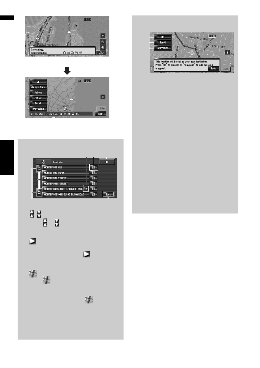
Operation of street list screen
(4) (1)
(3)
Chapter 2Basic Operation NAVI
(2)
(1) Number of possible choices
(2) :
Touching or on the scroll bar scrolls
through the list and allows you to view the
remaining items.
(3) :
If all of characters cannot be displayed within
the displayed area, touching to the right
of the item allows you to see remaining characters.
(4) :
Touching displays a map of the place you
have selected. (Possibilities for place names
may appear with the list screen.) You can also
set a destination by touching to the right
of the list. Touch [OK] to set the location indicated by the scroll cursor as your destination.
(5) [Back]:
Returns previous screen.
(5)
Checking the location on the map
“Location confirmation screen”
(1)
(2)
(3)
(1)
Calculating the route to the destination
Route calculation starts. When the route calculation is completed, “Route confirmation
screen” appears.
❒ If you press the MAP button or MENU
button during route calculation, the calculation is cancelled and the map screen
appears.
(2)
Scrolling the map
The map display changes to the scroll mode.
You can fine-tune the location in the scroll
mode, and then you can set the location as
your destination or do various operations by
using the shortcut menu.
➲ “Shortcut menu” ➞ Page 36
(3)
Setting the location as a waypoint
The location indicated by the scroll cursor will
be set as a waypoint.
➲ “Editing Waypoints” ➞ Page 29
24
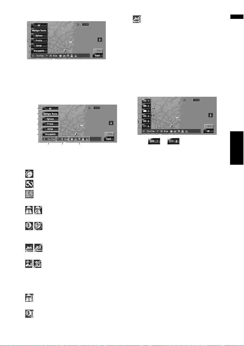
8 Touch [OK] to decide your route.
Checking and modifying the
route
You can check the route details. You can also
recalculate the route in different conditions.
Route confirmation screen
(4)
(5)
(6)
(7)
(8)
(9)
(3) (2) (1)
(1) Route calculation condition
Shows the route has been calculated under those
conditions.
• shows that fastest route is prioritised.
• shows that shortest route is prioritised.
• shows that using highways and main
roads are prioritised.
• shows whether the suggested route
includes motorways.
• shows whether the suggested route
includes toll roads. The current setting
appears.
• shows whether the suggested route
includes ferries. The current setting appears.
• shows whether the suggested route
includes learning routes. The current setting
appears.
In addition, if the calculated route has unintended results, the following icons will be shown.
• shows that motorways could not be
avoided.
• shows that toll roads could not be avoided
when the setting [Avoid Toll Road] is [On].
• shows that ferries could not be avoided
when the setting [Avoid Ferry] is [On].
(2) Distance to the destination
(3) Travel time to destination
(4) Set the displayed route
Sets the displayed route as your route, and starts
the route guidance.
➲ “When the route guidance starts” ➞ Page 26
(5) Display multiple routes
You can select a desired route from multiple
route options. Calculated routes are shown in different colours.
Chapter 2 Basic OperationNAVI
Touching to switch to another
route. Touching [OK] returns to the previous display.
If you set waypoints, you cannot use the multiple
route option.
❒ There can be cases that the same route is dis-
played even when multiple routes are
searched.
❒ In multiple route calculations, both routes
that use and avoid the motorways are calculated independently of the setting for [Avoid
Motorway].
(6) Change the route calculation condition
Modify each calculation condition, and recalculate the route.
➲ Refer to the steps after Step 3 of “Modifying
the Route Calculation Conditions” ➞ Page 27
(7) View the route profile
You can check the streets that you will travel to
reach the destination.
➲ Refer to the steps after Step 3 of “Checking
the passing streets with a list” ➞ Page 28
25

(8) Check the shape of route
You can check the overall shape of your route and
the location of destination on the map.
➲ Refer to the steps after Step 2 of “Checking
the entire route overview on the map” ➞
Page 28
(9) Adding and edit waypoint
You can add, remove, or sort waypoints.
➲ “Editing Waypoints” ➞ Page 29
Basic items on the screen
This section describes only the basic items that
are displayed on the Map Mode screen.
➲ Details of the map screen ➞ Page 31
When the route guidance starts
Touching [OK] in “Route confirmation screen”
starts the route guidance on the displayed route.
Your navigation system gives you the following
information with the timing adjusted to the speed
of your vehicle:
— Distance to the next turning point
— Direction of travel
— Road number of the motorway
— Arrival of waypoint (If waypoints are set)
— Arrival of your destination
❒
Touching
Chapter 2Basic Operation NAVI
voice guidance on or off.
❒ Touching allows you to hear the
information again.
❒ If you stop at a petrol station or a restaurant
during the route guidance, your navigation
system remembers your destination and route
Information. When you start the engine and
get back on the road, the route guidance
resumes.
❒ If you deviate from the route with guidance set
to [Street List Mode] or [Mixed Mode] and
enter a street not recorded on the hard disk
drive, the screen changes to [Map Mode].
When you return to the route, the screen
returns to the original view and resumes route
guidance.
or
allows you to turn the
(1)(3)(2) (4)
(1) Current location
(2) Distance to the destination
(3) Estimated time of arrival (default)
(4) ON/OFF key for voice guidance
Cancelling the Route Guidance
If you no longer need to travel to your destination
or if you want to change your destination, follow
the steps below to cancel the route guidance.
1 Touch [Destination] in the navigation
menu, then touch [Cancel Route].
A message confirming whether to cancel the
current route appears.
2 Touch [Yes].
The current route is deleted, and a map of
your surroundings reappears.
On this screen, you can also select the following items:
[Skip]:
Skip the route to the selected waypoint, and
recalculate the route. (The skipped waypoint
will not be deleted.)
[No]:
Returns to the previous display without deleting the route.
26
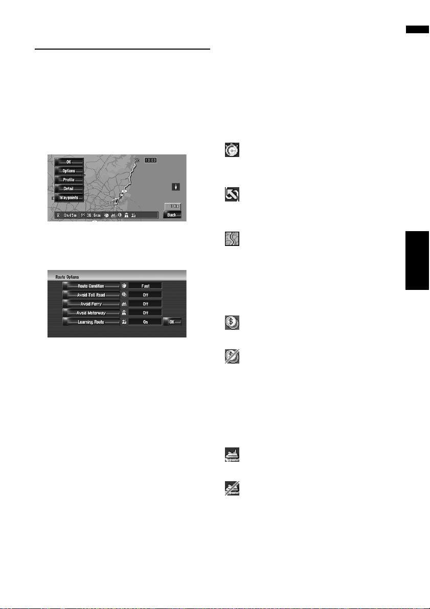
Modifying the Route Calculation
Conditions
You can modify the conditions for route calculation and recalculate the current route.
1 Touch [Destination] in the navigation
menu, and then touch [Route Overview].
❒ [Route Overview] is displayed only when
the route is set.
Items that users can operate
Settings marked with an asterisk (*) show that
these are default or factory settings.
Route Condition
This setting controls how the route should be calculated by taking into account the time or the distance or the main road.
Determine which condition takes priority for
route calculation.
2 Touch [Options].
3 Touch the desired items to change the
route calculation conditions and then
touch [OK].
The route is recalculated, and “Route confirmation screen” appears.
➲ “Checking and modifying the route” ➞
Page 25
When a single route is calculated, the system
searches for the route that meets these conditions as closely as possible.
❒ A single route is calculated in the following
cases:
— When a waypoint is set
— When a route is set through voice recogni-
tion
[Fast]*:
Calculate a route with the shortest travel time to
your destination as a priority.
[Short]:
Calculate a route with the shortest distance to
your destination as a priority.
[Main Road]:
Calculate a route that passes major arterial road
as a priority.
Avoid Toll Road
This setting controls whether toll roads should be
taken into account.
[Off]*:
Calculate a route that may include toll roads.
[On]:
Calculate a route that avoids toll roads.
❒ The system may calculate a route that
includes toll road even if [On] is selected.
Avoid Ferry
This setting controls whether ferry crossings
should be taken into account.
[Off]*:
Calculate a route that may include ferries.
[On]:
Calculate a route that avoids ferries.
❒ The system may calculate a route that
includes ferry way even if [On] is selected.
Chapter 2 Basic OperationNAVI
Avoid Motorway
This setting controls whether motorways may be
included in the route calculation.
27

[Off]*:
Calculate a route that may include motorways.
[On]:
Calculate a route that avoids motorways.
❒ The system may calculate a route that
includes motorway even if [On] is selected.
2 Touch [Profile].
Learning Route
The system learns the travel history of your vehicle for each road.
This setting controls whether or not the travel history should be taken into account.
[On]*:
Calculate the route with the travel history taken
into account.
[Off]:
Calculate the route without the travel history
taken into account.
[Clear]:
Clear the current travel history.
Chapter 2Basic Operation NAVI
Checking the Current Route
You can check information about the route
between your current location and your destination.
You can select two methods:
• Checking the passing streets with a list
• Checking the entire route overview on the map
Checking the passing streets
with a list
You can check the route details.
❒ This function is not available if your vehicle
has deviated from the route.
1 Touch [Destination] in the navigation
menu, and then touch [Route Overview].
“Route confirmation screen” appears.
❒ [Route Overview] is displayed only when
the route is set.
3 Touch or to scroll the list.
Scroll the list as necessary.
Names of the streets you are driving through
Turning direction
Driving distance
4 Touch [Back].
You can return to the previous display.
❒ When a long distance route is calculated,
your navigation system may not be able to
list all roads. (In this case, the remaining
roads will be shown in the list as you drive
on.)
Checking the entire route overview on the map
You can check the entire shape of the current route.
1 Touch [Destination] in the navigation
menu, and then touch [Route Overview].
“Route confirmation screen” appears.
❒ [Route Overview] is displayed only when
the route is set.
2 Touch [Detail].
28
 Loading...