


 Loading...
Astro™
owner’s manual
GPS-enabled dog tracking system

© 2008 Garmin Ltd. or its subsidiaries |
|
|
Garmin International, Inc. |
Garmin (Europe) Ltd. |
Garmin Corporation |
1200 East 151st Street, |
Liberty House |
No. 68, Jangshu 2nd Road, |
Olathe, Kansas 66062, USA |
Hounsdown Business Park, |
Shijr, Taipei County, Taiwan |
Tel. (913) 397.8200 or (800) 800.1020 |
Southampton, Hampshire, SO40 9RB UK |
Tel. 886/2.2642.9199 |
Fax (913) 397.8282 |
Tel. +44 (0) 870.8501241 (outside the UK) |
Fax 886/2.2642.9099 |
|
0808 2380000 (within the UK) |
|
|
Fax +44 (0) 870.8501251 |
|
All rights reserved. Except as expressly provided herein, no part of this manual may be reproduced, copied, transmitted, disseminated, downloaded or stored in any storage medium, for any purpose without the express prior written consent of Garmin. Garmin hereby grants permission to download a single copy of this manual onto a hard drive or other electronic storage medium to be viewed and to print one copy of this manual or of any revision hereto, provided that such electronic or printed copy of this manual must contain the complete text of this copyright notice and provided further that any unauthorized commercial distribution of this manual or any revision hereto is strictly prohibited.
Information in this document is subject to change without notice. Garmin reserves the right to change or improve its products and to make changes in the content without obligation to notify any person or organization of such changes or improvements. Visit the Garmin Web site (www.garmin.com) for current updates and supplemental information concerning the use and operation of this and other Garmin products.
Garmin®, AutoLocate®, TracBack®, BlueChart®, MotionBased®, City Navigator®, and MapSource® are registered trademarks and Astro™ is a trademark of Garmin Ltd. or its subsidiaries and may not be used without the express permission of Garmin.
This product includes technology owned by SiRF Technology, Inc. SiRF’s technology is protected by U.S. and foreign patents pending and issued. SiRF, SiRFstar and the SiRF logo are registered trademarks of SiRF Technology, Inc. SiRFstarIII and SiRF Powered are trademarks
of SiRF Technology, Inc.
Windows® is a registered trademark of Microsoft Corporation in the United States and/or other countries. Macintosh® is a registered trademarks of Apple Computer, Inc. microSD™ is a trademark of The SD Card Association. TransFlash™ is a trademark of SanDisk Corporation. Other trademarks and trade names are those of their respective owners.
May 2008 |
Part Number 190-00714-10 Rev. A |
Printed in Taiwan |

Introduction
This manual provides user information for the Garmin® Astro™ 220 Dog Tracking System.
Tips and Shortcuts
•Press MENU twice to return to the Main Menu from any page.
•Press BACK to move backward through your steps.
•To extend battery life of the Astro 220, turn the unit off when you are not using it, and decrease the level of the display backlight (page 4).
•To extend the DC 30 battery life, turn the unit off when you are not tracking a dog, or decrease the update rate (page 13).
Product Registration
Help us better support you by completing our online registration today! Connect to our Web site at www.my.garmin.com. Keep the original sales receipt, or a photocopy, in a safe place.
Introduction
Contact Garmin
Contact Garmin if you have any questions while using your Astro 220. In the USA contact Garmin Product Support by phone: (913) 397-8200 or (800) 800-1020, or go to www.garmin.com/support/.
In Europe, contact Garmin (Europe) Ltd. at +44 (0) 870.8501241 (outside the UK) or 0808 2380000 (within the UK).
myGarmin
Go to www.my.garmin.com to access the latest services for your Garmin products.
•Subscribe to online services for Points of Interest (POIs) and other useful items.
•Unlock optional maps.
•Access MotionBased® Web-based activity tracker where you can view your saved tracks.
•Download geocaches to your unit.
Astro Dog Tracking System Owner’s Manual |
i |

Introduction |
|
Table of Contents |
|
Introduction............................................................. |
i |
Tips and Shortcuts....................................................... |
i |
Product Registration.................................................... |
i |
Contact Garmin............................................................ |
i |
myGarmin.................................................................... |
i |
DC 30 Battery Warnings............................................ |
iv |
Getting Started....................................................... |
1 |
Unit Overview.............................................................. |
1 |
Installing the Batteries in the Astro 220....................... |
2 |
Using the Astro 220 Keypad Functions....................... |
3 |
Turning the Astro 220 On............................................ |
4 |
Charging the DC 30.................................................... |
4 |
Acquiring GPS Satellite Signals.................................. |
5 |
Calibrating the Astro 220 Compass............................ |
6 |
Operating the Astro 220.............................................. |
6 |
Manual Conventions................................................... |
7 |
On-Screen Messages................................................. |
7 |
Dog Tracking.......................................................... |
8 |
Communicating with the DC 30.................................. |
8 |
Tracking a Dog.......................................................... |
10 |
Main Menu............................................................. |
14 |
Mark Location....................................................... |
15 |
Averaging a Marked Location................................... |
16 |
Projecting a Location................................................ |
16 |
Map Page.............................................................. |
17 |
Map Page Options.................................................... |
17 |
Data Fields................................................................ |
18 |
Measuring Distance.................................................. |
19 |
Find Features........................................................ |
20 |
Item Information Page Options................................. |
22 |
Using Optional Detailed Maps.................................. |
22 |
POI Loader and Custom Points of Interest............... |
23 |
GPS Applications................................................. |
24 |
Using the Trip Computer........................................... |
24 |
Using the Compass Page......................................... |
25 |
Using the Altimeter Page.......................................... |
28 |
Using Tracks............................................................. |
30 |
Creating Routes........................................................ |
34 |
Using the Highway Page........................................... |
37 |
Using Proximity Locations......................................... |
37 |
Using Turn Preview................................................... |
38 |
Using Active Route.................................................... |
39 |
Using the Satellite Page............................................ |
39 |
ii |
Astro Dog Tracking System Owner’s Manual |

Accessories.......................................................... |
41 |
Calendar................................................................... |
41 |
Calculator.................................................................. |
42 |
Stopwatch................................................................. |
42 |
Sunrise/Sunset.......................................................... |
42 |
Hunting Almanac....................................................... |
43 |
Games...................................................................... |
43 |
Settings................................................................. |
44 |
System Setup............................................................ |
44 |
Dog List Setup.......................................................... |
45 |
Dog Alerts Setup....................................................... |
45 |
Display Setup............................................................ |
45 |
Tones Setup.............................................................. |
46 |
Main Menu Setup...................................................... |
46 |
Map Setup................................................................. |
46 |
Routing Setup........................................................... |
49 |
Geocache Setup....................................................... |
51 |
Marine Alarms Setup................................................. |
51 |
Time Setup................................................................ |
51 |
Units Setup............................................................... |
52 |
Heading Setup.......................................................... |
52 |
Calibration Setup...................................................... |
53 |
Altimeter Setup......................................................... |
53 |
|
Introduction |
Appendix............................................................... |
54 |
Specifications............................................................ |
54 |
Optional Accessories................................................ |
56 |
Transferring Data...................................................... |
56 |
Caring for the Astro 220 System............................... |
60 |
Software License Agreement.................................... |
61 |
Index...................................................................... |
64 |
Astro Dog Tracking System Owner’s Manual |
iii |

Introduction
See the Important Safety and Product Information guide in the product box for product warnings and other important information.
NOTICE REGARDING LEGAL RESTRICTIONS; SPECIAL NOTICE TO USERS IN CALIFORNIAAND ALASKA:
State law in California prohibits the use of GPS dog collars for the pursuit of mammals. Alaska law prohibits guides from using GPS devices to assist in the taking of big game animals. This is not intended to be an exhaustive list of applicable laws and ordinances, and Garmin makes no such guarantees or warranties that this list is
complete. Check your state and local laws and ordinances to ensure you fully understand any restrictions applicable to this product in your jurisdiction prior to purchase and/or use. Garmin does not assume any responsibility for any fines, penalties, or damages that may be incurred as a result of any state or local law or ordinance relating to use of the product.
DC 30 Battery Warnings
If these guidelines are not followed, the internal lithium-ion battery may experience a shortened life span or may present a risk of damage to the DC 30, fire, chemical burn, electrolyte leak, or injury.
•Contact your local waste department to properly dispose of the unit/battery.
•Do not leave the unit exposed to a heat source or in a
high temperature location, such as in the sun in an unattended vehicle on a hot day. To prevent damage, remove the unit from the vehicle or store it out of direct sunlight, such as in the glove box.
•Do not incinerate the DC 30 or the battery.
•When storing the unit for a limited length of time, store within the following temperature range: from -4˚F to 104˚F (from -20˚ to 40˚C). When storing the unit for an extended time, store within the following temperature range: from 32˚F to 77˚F (from 0˚ to 25˚C).
•Do not operate the unit outside of the following temperature range: from -4˚ to 140˚F (from -20˚ to 60˚C).
•Recharge the unit within the following temperature range: from
32˚F to 113˚F (from 0˚ to 45˚C).
The DC 30 contains a replaceable, rechargeable lithium-ion battery, the following warnings also apply:
•Do not recharge the battery outside of the unit or disassemble the battery.
•Keep the used battery away from children. Do not disassemble, puncture, or damage the battery.
•Replace the battery with a Garmin lithium-ion battery pack. Using another battery presents a risk of fire or explosion. To purchase a replacement battery, see your Garmin dealer or the Garmin Web site (www.garmin.com).
•Do not leave the DC 30 where a dog may attempt to chew on it. If the battery cell is punctured, electrolyte can be released that can be harmful to the dog.
iv |
Astro Dog Tracking System Owner’s Manual |

Unit Overview
 Power
Power
key
LCD screen 
Keypad
Getting Started
Getting Started
Belt clip button attachment
Wrist strap attachment slot
Battery compartment locking D-ring
Battery compartment cover and access to the microSD™ card tray
VHF antenna
GPS  antenna
USB port (under weather cap)
Battery |
DC 30 |
charging port
Astro Dog Tracking System Owner’s Manual |
|
Getting Started
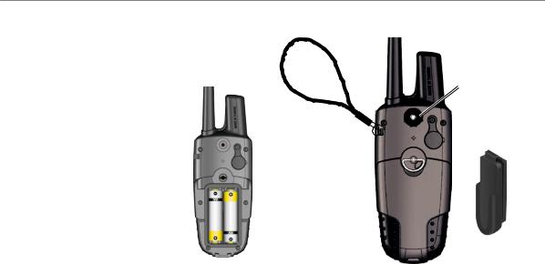
Installing the Batteries in the Astro 220
The Astro 220 operates on two AA alkaline, lithium or NiMH batteries (not included). See page 44 for information on setting the battery type.
To install the batteries:
1.Turn the D-ring ¼ turn counterclockwise and remove the battery cover.
2.Insert the batteries, observing the proper polarity.
3.Reinstall the battery cover.
Remove the batteries from your
Astro 220 when you do not expect to use the unit for several months. When you remove the batteries, data is not lost.
To install the wrist strap:
Battery
Compartment
1.Place the small loop of the wrist strap through the slot on the back of the unit.
2.Route the strap through the loop and pull the end of the strap.
Belt clip button installation (tighten the button securely
by turning it
clockwise)
Wrist strap  installation
Belt clip
See page 57 to install or remove the microSD data card in the battery compartment.
|
Astro Dog Tracking System Owner’s Manual |

Getting Started
Using the Astro 220 Keypad Functions
IN/OUT zoom–Press to zoom in or out on the Map page. Press to scroll up or down a list on any other page.
DOG–Press at any time to view the Dog Tracker page.
MARK–Press to mark your current location.
BACK–Press to cancel data entry or move backward to the Main Menu.
MAP–Press to view the Map page.
Rocker–Press up, down, left, or right to  highlight options and to enter data, or to move
the map-panning arrow.
MENU–Press to view page options. Press twice to view the Main Menu.
ENT (Enter)–Press to enter highlighted options, select data, or confirm on screen messages.
Astro Dog Tracking System Owner’s Manual |
3 |

Getting Started
Turning the Astro 220 On
To turn the Astro 220 on, press and hold the  Power key.
The first time you turn theAstro 220 on, a message appears followed by a prompt. Thereafter, when you turn the Astro 220 on, the Garmin Logo appears, followed by the Dog Tracker page.
|
|
|
Garmin Logo |
Dog Tracker Page |
|
To adjust the backlight level:
1. Press and quickly release the  Power key.
2.Press the Rocker up arrow or down arrow to adjust
the brightness levels. Or, press and quickly release
the  Power key to cycle through the brightness levels.
3.Press ENTER to select a brightness level.
See page 45 to change the display colors and backlight timeout.
Charging the DC 30
Fully charge the DC 30 before using it on a hunt. DC 30 charging temperature range is 32°F-113°F (0°C-45°C).
To charge the DC 30:
1.Connect the vehicle power cable or the AC adapter to an appropriate electrical source.
2.Slide the connector into the battery charging port on
the side of the DC 30.
Battery charging port
Blue LED 
|
Astro Dog Tracking System Owner’s Manual |
3.Charge the DC 30 until the blue LED on the bottom of the unit turns off.
Note: Charging a fully-depleted DC 30 battery requires 4½ hours.
To turn the DC 30 on and off:
1.Press and hold the DC 30  Power key. The red LEDs blink at a steady rate.
2.To turn the DC 30 off, press and hold the  Power key.
DC 30
Power key
LEDs blink red Battery when power is on
charging port
Getting Started
Acquiring GPS Satellite Signals
Before theAstro 220 can find your current location and the location of the DC 30, both units must acquire GPS signals.
Note: The DC 30 does not transmit its location to the Astro 220, and the Astro 220 will not indicate the location of the DC 30, until both units have acquired satellite signals.
To acquire GPS satellite signals:
1.Go outdoors to an open area, away from tall buildings and trees.
2.Turn the Astro 220 and DC 30 on. Acquiring satellite signals can take a few minutes.
The  bars on the Astro 220 indicate satellite strength. When the bars are black, the Astro 220 has acquired satellite signals. The two red LEDs on the
DC 30 double blink at each pulse when a location fix is achieved.
Astro Dog Tracking System Owner’s Manual |
|

Getting Started
Calibrating the Astro 220 Compass
Calibrate theAstro 220 electronic compass the first time you use it, after periods of storage, after you install new batteries, or when the unit has been exposed to temperature changes of greater than 20°F (11°C).
Calibrate the compass outdoors. Hold the compass level and away from objects that generate magnetic fields, such as cars or buildings.
To calibrate the electronic compass:
1.On the Dog Tracker page (page 4), press MENU.
2.Select Calibrate Compass, and press ENTER.
3.Select Start, press ENTER, and follow the on-screen
directions.
Hold the unit level and turn slowly.
•“Just Right,” “Too Fast,” or “Too Slow” appears, notifying you to adjust your turning speed. Hold the unit level while turning.
•When “Calibration Successful” appears, press
ENTER.
•If “Calibration Failed” appears, repeat the process.
Operating the Astro 220
The following terms are used throughout this manual:
Select–move the highlighted area on the screen up, down, left, or right with the Rocker to select individual fields.
Field–the location on a page where data or an option can be shown and entered.Ahighlighted field appears yellow.
On-screen button–an option on the screen. Use the Rocker to select a button, and press ENTER.
Scroll bar–a bar that appears on the right side of a list that is too long to fit on the screen. Use the Rocker to scroll through a list. Press IN or OUT to scroll a set of items.
|
Astro Dog Tracking System Owner’s Manual |

Default–the saved factory settings. You can change the settings, but you can revert to the factory settings by selecting Restore Defaults.
Wizard–an on-screen guide to performing functions that require multiple steps and options.
Manual Conventions
In this manual, small arrows (>) indicate that you should highlight a series of items on the screen using the Rocker, and press the ENTER key after each item. For example, if you see “select Dog > Show Info,” highlight Dog, press ENTER, highlight Show Info, and press ENTER again.
Using the Status Bar
The status bar at the top of each Astro 220 page provides status information.
Status Bar
Getting Started
• –indicates the remaining battery power.
• –appears when the Astro 220 is powered by an external source.
• –indicates the strength of acquired satellite signals.
• –blinks when the unit detects a signal (for example, a DC 30) on the channel it is receiving.
On-Screen Messages
When an on-screen message appears, press ENTER to acknowledge the message and close the window.
Messages also indicate temporary conditions, such as “Calculating Route.” The message window closes as soon as the process is completed.
Astro Dog Tracking System Owner’s Manual |
|
Dog Tracking
Dog Tracking
This section describes communications between the DC 30 and the Astro, tracking dogs on the map, and adding dogs to the Dog List.
Communicating with the DC 30
The DC 30 that was packaged with your Astro 220 System was linked with the Astro 220 at the factory. If you are using a DC 30 that you ordered separately, follow the instructions for adding a new dog on page 12 to establish communications with the Astro 220.
To view communication status with the DC 30:
Press DOG to view the Dog Tracker page. The dog name is listed in the Name field.
Note: The DC 30 does not transmit its location to the Astro 220, and the Astro 220 will not indicate the location of the DC 30, until both units have acquired satellite signals.
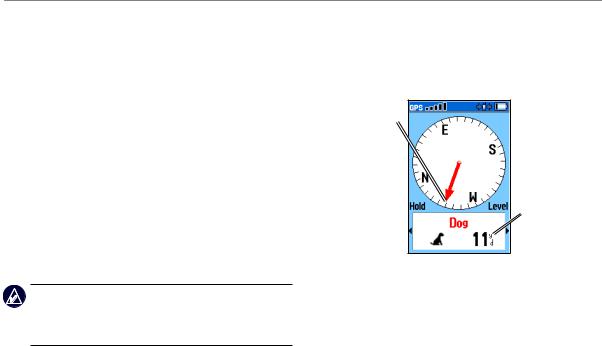
When communicating with the DC 30, the Dog Tracker page indicates the direction of the dog, the distance away from you, and the status of the dog. The Astro 220 can keep track of ten dogs. Use the Rocker to scroll through the list of dogs.
Dog pointer (direction to the dog)
Distance to Dog status the dog
icon 
Dog Tracker Page
To view details about a selected dog:
1.Use the Rocker to select a dog on the list.
2.Press ENTER to view the Dog Information page.
|
Astro Dog Tracking System Owner’s Manual |

Dog status |
Dog name |
|
field |
||
fields |
||
|
||
Position update |
DC 30 battery |
|
rate and dog |
||
communication |
capacity |
|
ID number |
DC 30 |
|
(page 13) |
||
communication |
||
DC 30 GPS |
||
signal strength |
||
signal strength |
|
|
Dog Information Page |
|
The Dog Information page displays the status of the dog (Running, Sitting, Treed, On point, or Unknown?), the distance from your location, the distance traveled, and the average speed.
Dog Tracking
Naming the Dog
The Astro 220 assigns a name such as Dog or Dog 1 to every Dog Unit (DC 30) linked to it.
To change the name of the dog:
1.On the Dog Information page, highlight the Name field and press ENTER.
2.Use the Rocker and ENTER to spell the name of the dog.
3.Select OK > ENTER when you are finished.
Using Go To, Map, and Reset
•Select Go To to navigate to your dog.
•Select Map to view the location and movement of your dog.
•Select Reset to reset the dog statistics and the track log (page 30) for that dog.
Astro Dog Tracking System Owner’s Manual |
|

Dog Tracking
Dog Information Page Options
On the Dog Information page, press MENU to access additional dog information options.
•Stop (or Start) Tracking–stops (or starts) tracking the dog.
•Identify Dog Unit–displays the DC 30 software version on the Astro and causes the DC 30 LEDs to blink rapidly for ten seconds.
•Change Comm. Settings–allows you to assign a new ID number (page 13) to a dog to avoid conflicting signals and/or the rate of reporting (5, 10, or 30 seconds).
•Transfer Dog Unit Track–transfers detailed tracks from the DC 30 to a computer (page 60).
•Delete Dog Unit Track–deletes the track log for the dog.
•Change Dog Unit Type–allows you to identify the dog type so that the appropriate dog status symbols are shown. Choose from Auto, Pointing Dog, Treeing Dog, or Pet.
•Upgrade Dog Unit–downloads software updates to the DC 30 (page 59).
Tracking a Dog
Attach the DC 30 with the collar to your dog’s neck with the VHF antenna (page 1) pointing up.
To ensure maximum compass accuracy, calibrate your compass (page 6) and hold the Astro 220 level.
Tracking a Dog on the Dog Tracker Page
The Dog Tracker page shows the direction and distance of the dog from the Astro 220, and the status of the dog.
10 |
Astro Dog Tracking System Owner’s Manual |

To view the Dog Tracker page:
Press DOG.
The dog you are tracking is identified and the dog pointer indicates its direction from you. The dog pointer is most accurate when you are holding the Astro 220 level and the dog is farther than 30 feet (9.1 meters) away. At less than that distance, a NEAR message appears, and the dog pointer is shortened. When you are close to the dog, the dog pointer may be inaccurate.
To change the color of your dog’s pointer, see page 31.
Dog Status Icons
Sitting Running On point |
Treed |
Unknown |
The Unknown status symbol [?], indicates that the DC 30 has not acquired a satellite signal and that the Astro 220 cannot determine the location of the dog.
To track a dog on the Map page:
Press MAP.
Dog Tracking
The Map page indicates the following:
•The location of the dog, its name, and a track showing its movements
•Your location and track
Marked |
|
Accuracy circle |
locations on |
|
|
|
|
|
map |
|
Your position is |
|
|
|
Dog status icon |
|
indicated by the |
|
position pointer |
|
|
|
|
Dog track |
|
|
|
|
|
Note: When the Map page is in the Track Up orientation mode, objects on the map appear to rotate around your position. As you move, the entire map reorients in the direction you are facing. To stabilize the objects, set the orientation to North Up (page 47).
For more information about the Map page features and custom settings, refer to page 46.
Astro Dog Tracking System Owner’s Manual |
|

Dog Tracking
Dog Tracker Page Options Menu
To open the Dog Tracker page Options menu:
On the Dog Tracker page, press MENU.
•Show Info–opens the Dog Information page for the selected dog.
•Pause (or Resume) All Tracking–pauses tracking of all dogs.
•Calibrate Compass–calibrates the compass (page 6).
•View Dog List–opens the Dog List to add or remove dogs.
•Small Numbers (or Big Numbers)–changes the size of the dog descriptions on the Dog Tracker page. Press the left or right arrows on the Rocker to scroll through multiple dogs in the Big Numbers mode.
Adding Dogs to the Dog List
If you purchase additional DC 30 units, you can link them to the Astro 220 using the setup wizard in the Dog List. To link, the Astro 220 must be close enough to the DC 30 to touch it, or you must know the DC 30 ID number.
To add a new dog to the list:
1.On the Dog Tracker page, press MENU > Dog List > <Add New> > ENTER to open the setup wizard.
2.Use the Rocker and ENTER to select and confirm options. By default, the new dog is named “Dog” and an ID number is randomly assigned.
Note: The setup wizard may indicate that there is a conflict with the ID number of another dog. To resolve the conflict, follow the instructions in the setup wizard and in “Conflicting Dog Signals.”
Conflicting Dog Signals
Each dog you track has its own ID number. If two dogs within range of the Astro 220 have the same ID, the
Astro 220 warns you of a conflicting ID signal. It then opens a setup wizard to guide you through the process of resolving the conflict.
If necessary, you can manually assign a new ID number to a dog. When possible, you should allow the Astro 220 to automatically assign IDs.
12 |
Astro Dog Tracking System Owner’s Manual |
To assign a new ID number to a dog and change the update rate:
1.On the Dog Information page, press MENU > Change Comm. Settings.
2.Select an unassigned and nonconflicting ID > OK.
3.Change the update rate, if desired. Both 10-second and 30-second updates reduce battery drain, but they create a less-detailed dog track and collected statistics.
4.Ensure that the Astro 220 is within a few feet of the DC 30.
5.Complete the setup wizard instructions.
Tips for Successful Tracking
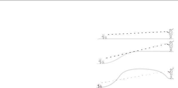
•Use a fully charged DC 30. A fully charged DC 30 operates for approximately 17 hours when using 5 second interval reporting.
•Use line-of-sight radio communication. The Astro 220 and DC 30 use radio signals to communicate. Objects in the path of radio signals degrade the quality of
the signals. Keeping an unobstructed line of sight
Dog Tracking
between you and your dog’s DC 30 produces the best communication signal. Obstructed radio waves result in a poor signal. To achieve the best line-of-sight conditions, move to the highest elevation point in your area (for example, on the top of a hill).
BEST
GOOD
POOR
Line-of-Sight Radio Communication
Astro Dog Tracking System Owner’s Manual |
3 |

Main Menu
Main Menu
To open the Main Menu, press MENU > MENU.
Note: Items shown on the Main Menu can be moved, deleted, or added as described on page 46.
Main Menu
Start New Hunt–resets dog statistics and track logs, and marks your starting location.
Go To Marked Location–provides directions to a location you have marked (page 15).
View Sunrise/Sunset–shows the time of sunrise, sunset, moonrise, and moonset, and current relative positions of the sun and moon.
•To view the rise and set times for a different date or location, select the Date field to open the on-screen keypad or select the New Location menu.
•To view positions of the sun and moon at a different time, select the Time field.
View Hunting Almanac–provides predicted best times for hunting and fishing for a specific date and location.
•To view predictions for a different date, select the
Date field.
•To view predictions for a different location, select the Location field > Use Map and select a point using the Rocker. Select Use Find Menu to view locations stored on the map.
Advanced–displays advanced options.
•Find (page 20)
•GPS Applications (page 24)
•Accessories (page 41)
•Settings (page 44)
14 |
Astro Dog Tracking System Owner’s Manual |
Mark Location
Locations are landmarks that you record and store in your Astro 220.
To mark your vehicle location:
When beginning a hunt, select Start New Hunt (page 14) while you are near your vehicle to mark the location. After the hunt, you can use your Astro 220 to navigate back to your starting location.
To mark your current location:
1.Press MARK > New to view the Mark Location page.
2.Select OK to mark the location.
To mark a specific hunting location:
1.Press MARK.
2.Select a name and hunting-related symbol to describe the location, and press ENTER.
Note: The Mark Covey option allows you to enter the estimated number of birds flushed and the number taken.
Mark Location
3.To edit location information, select the appropriate field, and press ENTER to open the on-screen keypad.After entering and confirming your changes, select OK (on the keypad).
4.Select OK to mark the location.
To mark a location using the Map page:
1.Press MAP. Use the Rocker to move the map pointer to the map item you want to mark as a location.
2.Press ENTER. If the map item selected contains no information, a “No map information at this point. Do you want to mark a location here?” message appears. Select Yes.
3.To edit location information, select the appropriate field, and press ENTER to open the on-screen keypad.After entering and confirming your changes, select OK (on the keypad).
4.Select OK to mark the location.
Astro Dog Tracking System Owner’s Manual |
|

Mark Location
To edit a marked location:
1.Press MENU > MENU > Advanced > Find > Marked Locations to open the Location page.
2.Select the location you want to edit.
3.Select the appropriate field to open the on-screen keypad.After entering and confirming your changes, select OK (on the keypad).
To move a marked location on the Map page:
1.Press MENU > MENU > Advanced > Find > Marked Locations.
2.Select the marked location you want to edit.
3.Select Map to show the marked location on the map.
4.Press ENTER to place a MOVE marker next to the marked location.
5.Use the Rocker to move the marked location to a new location on the map, and press ENTER.
Averaging a Marked Location
You can average a marked location for more accuracy. When averaging, the Astro 220 takes several readings at the same location and uses the average value to provide more accuracy.
To calculate your current average location:
1.Press MARK > New > Avg to begin averaging.
2.When the EstimatedAccuracy field reaches the level of accuracy you want, select Save > OK.
Projecting a Location
You can create a new location by projecting the distance and bearing from a marked location to a new location.
To project a location:
1.Press MENU > MENU > Advanced > Find > Marked Locations.
2.Select the location > MENU > Project Location.
3.Enter the bearing and distance to the projected location in the appropriate fields at the bottom of the page. To navigate to the location, select Go To.
16 |
Astro Dog Tracking System Owner’s Manual |

Map Page
The Astro 220 includes a preloaded basemap that includes cities, interstates, state and county highways, exit information, and lake and river outlines. The standard basemap can be enhanced using MapSource® detailed mapping data as shown below.
Map orientation |
|
|
arrow |
|
|
Map details from |
|
|
Garmin MapSource |
|
|
City Navigator® |
|
Your current |
North America NT |
|
|
|
location |
|
|
|
|
Map scale |
|
Dog location |
|
|
|
|
|
|
Map Page
Press MAP to display the Map page. Use the Rocker to move the map pointer  away from your current location. As you pan past the edge of the current map display, the screen scrolls to provide continuous map coverage.
Map Page
Press IN and OUT to change the map scale. An accuracy circle represents the area containing your current location.
Map Page Options
Customize the Map page using the Map page Options menu. On the Map page press MENU.
•Stop (or Resume) Navigation–stops or resumes navigation.
•Recalculate–recalculates an automotive route while navigating.
•Data Fields–configures up to four data fields at the top of the page (page 18).
•Change Data Fields–changes the type of data displayed in the data fields (page 18).
•Guidance Text–displays useful information on the screen above the map when navigating to a destination.
•Setup Map–customizes the map to your preferences (page 47).
Astro Dog Tracking System Owner’s Manual |
|
Loading...