


dēzl® 560
quick start manual Manuel de démarrage rapide
January 2011 |
Part Number 190-01280-90 Rev. B |
Printed in Taiwan |
Getting Started
WARNING
See the Important Safety and Product Information guide in the product box for product warnings and other important information.
Before you use your device for the first time, you should complete these tasks.
1.Mount the device (page 2).
2.Register the device (page 4).
3.Check for updates:
•Software updates (page 4).
•Free map update (page 5).
4.Download the full owner’s manual (page 5).
5.Enter a truck or RVprofile (page 6).
Mounting the Device
WARNING
This product contains a lithium-ion battery.To prevent the possibility of personal injury or product damage caused by battery exposure to extreme heat, remove the device from the vehicle when exiting or store it out of direct sunlight.
Before you use your device on battery power, you should charge it.
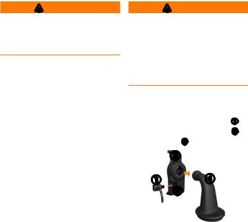
1.Plug the vehicle power cable into the mini-USB connector on the cradle .
EN-2 |
dēzl 560 Quick Start Manual |
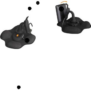
2.Snap the cradle onto the arm .
3.Slide the locking lever on the base to the unlocked position.
4.Slide the disk on the bottom of the arm into the base until it clicks.
5.Slide the locking lever to the locked position.
6.Fit the bottom of the device into the cradle.
7.Tilt the device back until it snaps.
8.Plug the other end of the vehicle power cable into a power outlet in your vehicle.
After you have connected the device to vehicle power, the following occurs.
•The device turns on.
•The device acquires satellite signals.When at least one of
the  bars is green, your device has acquired satellite signals.
NOTE:The device may need a clear view of the sky to acquire satellite signals.
dēzl 560 Quick Start Manual |
EN-3 |
•The device charges as you drive.  in the status bar indicates the status of the internal battery.
About myDashboard
Use myDashboard to register your device, check for software and map updates, access product manuals and support, and more.
Setting Up myDashboard
1.Connect the USB cable to the micro-USB connector on the device.
2.Connect the USB cable to the USB port on your computer.
3.Go to www.garmin.com /dashboard.
4.Follow the on-screen instructions.
Registering the Device
1.From myDashboard, click
Register Now.
2.Follow the on-screen instructions.
3.Keep the original sales receipt, or a photocopy, in a safe place.
Updating the Software
1.Open myDashboard (page 4).
2.If necessary, under Software Updates, click Update Now.
3.Follow the on-screen instructions.
EN-4 |
dēzl 560 Quick Start Manual |
nüMaps Guarantee™
Your device is eligible for one free map update within 60 days of
acquiring satellites while driving with your device.You are not eligible for the free map update if you register by phone or wait longer than 60 days after the first time you acquire satellites while driving with your device. For more information, go to www.garmin.com/numaps.
Updating Maps
1.Open myDashboard (page 4).
2.Register the device (page 4).
3.If necessary, under Map Updates, click Update Now.
4.Follow the on-screen instructions.
Downloading the Owner’s Manual
The owner’s manual for your device is available on the GarminWeb site. The owner’s manual for the dēzl includes more information about the device features for semi-trailer trucks and RVs.
1.Open myDashboard (page 4).
2.Click Manuals.
3.Click Download next to the manual you want.
4.Click  to save the file to your computer.
dēzl 560 Quick Start Manual |
EN-5 |
Entering a Truck or RV Profile
WARNING
Entering your vehicle profile does not guarantee that your vehicle’s characteristics will be accounted for in all route suggestions. It is your responsibility to account for your vehicle’s height, length, weight, and other relevant restrictions when driving.Always defer to all posted road signs and road conditions when making driving decisions.
Before you can operate inTruck or RVmode, you must enter your truck or RVprofile.
Truck transportation mode is selected the first time you turn on your device. You can select Switch Mode to enter an RVprofile.
1.When the warning screen appears, touch Agree.
2.Touch Yes to enter your truck profile.
3.Follow the on-screen instructions.
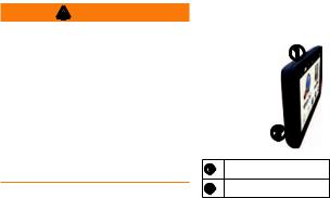
Device Overview
Power key
microSD™ card slot
Resetting the Device
You can reset the device if it stops functioning.
1.Hold the Power key for 8 seconds, and release it.
The device turns off.
EN-6 |
dēzl 560 Quick Start Manual |
2.Wait 1 second.
3.If the device is using battery power, press and release the
Power key.
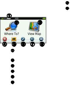
Using the Main Menu
•Touch to select a transportation mode.
•Touch to find a destination.
•Touch to view the map.
•Touch to stop a route.
•Touch to detour a route.
•Touch to make a call when connected to a compatible mobile
phone.
Go to www.garmin.com/bluetooth for information.
•Touch to adjust the volume.
•Touch to open the menu of tools and settings.
Finding Trucking Points of Interest
The detailed maps loaded in your device contain trucking points of interest, such as rest areas, truck stops, and weigh stations.
1.From the main menu, touch
Where To? > Points of Interest > Trucking.
2.Select a category.
3.If necessary, select a subcategory.
4.Select a destination.
5.Touch Go!.
dēzl 560 Quick Start Manual |
EN-7 |

Using Exit Services
You can find services such as fuel, food, lodging, rest areas, vehicle repair, truck stops, and weigh stations at upcoming highway exits.The device displays available services based on the usage mode. Exit service information is available only on controlled access roads, such as interstates.
NOTE: Exit services are not available for Pedestrian mode.
1.While navigating a route, from the main menu, touch Where To? >
Exit Services.
2.Select an option.
Following Your Route
notice
The speed limit icon feature is for information only and does not replace the driver’s responsibility to abide by all posted speed limit signs and to use safe driving judgment at all times. Garmin will not be responsible for any traffic fines or citations that you may receive for failing to follow all applicable traffic laws and signs.
Your route is marked with a magenta line on the map. If you depart from the original route, your device recalculates the route.Aspeed limit icon could appear as you travel on major roadways.
When you are driving inTruck mode or RVmode, a tone may sound and  may appear, indicating that truck suitability for this roadway is unknown.Always obey posted signs
EN-8 |
dēzl 560 Quick Start Manual |
 Loading...