


 Loading...
™
models: 500, 510, 550, 560
Aviation Quick Reference Guide

Overview
GPS Navigation
Flight Planning
Hazard Avoidance
Utilities
Appendix
Index

Copyright © 2009 Garmin Ltd. or its subsidiaries. All rights reserved.
This manual reflects the operation of System Software version 0002.0 or later. Some differences in operation may be observed when comparing the information in this manual to earlier or later software versions.
Garmin International, Inc., 1200 East 151st Street, Olathe, Kansas 66062, U.S.A.
Tel: 913/397.8200 |
Fax: 913/397.8282 |
Garmin AT, Inc., 2345 Turner Road SE, Salem, OR 97302, U.S.A. |
|
Tel: 503/391.3411 |
Fax 503/364.2138 |
Garmin (Europe) Ltd, Liberty House, Bulls Copse Road, Hounsdown Business Park, |
|
Southampton, SO40 9RB, U.K. |
|
Tel: 44/0870.8501241 |
Fax: 44/0870.8501251 |
Garmin Corporation, No. 68, Jangshu 2nd Road, Shijr, Taipei County, Taiwan |
|
Tel: 886/02.2642.9199 |
Fax: 886/02.2642.9099 |
Web Site Address: www.garmin.com
Except as expressly provided herein, no part of this manual may be reproduced, copied, transmitted, disseminated, downloaded or stored in any storage medium, for any purpose without the express written permission of Garmin. Garmin hereby grants permission to download a single copy of this manual and of any revision to this manual onto a hard drive or other electronic storage medium to be viewed for personal use, provided that such electronic or printed copy of this manual or revision must contain the complete text of this copyright notice and provided further that any unauthorized commercial distribution of this manual or any revision hereto is strictly prohibited.
Garmin® and SafeTaxi® are registered trademarks of Garmin Ltd. or its subsidiaries. aera™ is a trademark of Garmin Ltd. or its subsidiaries. These trademarks may not be used without the express permission of Garmin.
Jeppesen® is a registered trademark of Jeppesen, Inc. XM® is a registered trademark of XM Satellite Radio, Inc.
October 2009 |
190-01117-03 Rev. A |
Printed in the United States or Taiwan |

|
|
|
Table of Contents |
|
Section 1 Overview......................................................................................... |
|
|
1 |
|
1.1 |
Unit Overview............................................................................................................ |
|
|
1 |
1.2 |
Getting Started.......................................................................................................... |
|
|
2 |
|
Battery Installation................................................................................................................ |
|
|
2 |
|
Charging the Battery............................................................................................................. |
|
|
3 |
|
Changing Modes.................................................................................................................. |
|
|
3 |
|
GPS Receiver Status.............................................................................................................. |
|
|
3 |
1.3 |
Operation................................................................................................................... |
|
|
4 |
|
Basic Navigation Controls..................................................................................................... |
|
4 |
|
|
‘Home’ Screen...................................................................................................................... |
|
|
5 |
|
Selecting a Function.............................................................................................................. |
|
|
8 |
|
Scrolling............................................................................................................................... |
|
|
9 |
1.4 |
Accessing System Functionality............................................................................... |
|
9 |
|
|
Option Menus....................................................................................................................... |
|
|
9 |
|
Data Entry.......................................................................................................................... |
|
|
10 |
1.5 |
Using Map Displays................................................................................................. |
|
|
11 |
|
Map Panning...................................................................................................................... |
|
|
11 |
|
Map Range......................................................................................................................... |
|
|
12 |
|
Map Overlays..................................................................................................................... |
|
|
12 |
Section 2 GPS Navigation............................................................................ |
|
13 |
||
2.1 |
Flight Data................................................................................................................ |
|
|
13 |
|
Data Fields......................................................................................................................... |
|
|
13 |
|
Numeric Flight Data............................................................................................................ |
|
|
13 |
2.2 |
HSI/Panel................................................................................................................... |
|
|
14 |
|
Changing the CDI Scale. |
..................................................................................................... |
|
14 |
|
Setting the Bug Indicator.................................................................................................... |
|
14 |
|
|
Manually Setting a Course.................................................................................................. |
|
14 |
|
2.3 |
Vertical Navigation (VNAV)..................................................................................... |
|
15 |
|
|
Using the VNAV Feature...................................................................................................... |
|
|
15 |
2.4 |
Waypoints................................................................................................................. |
|
|
16 |
|
Nearest Information............................................................................................................ |
|
|
17 |
|
Weather Information........................................................................................................... |
|
|
17 |
|
User Waypoints................................................................................................................... |
|
|
18 |
2.5 |
Direct-to Navigation................................................................................................ |
|
|
19 |
Section 3 Flight Planning............................................................................. |
|
|
21 |
|
3.1 |
Flight Plan Data Fields............................................................................................ |
|
21 |
|
3.2 |
Flight Plan Creation................................................................................................. |
|
|
21 |
3.3 |
Adding Flight Plan Waypoints................................................................................ |
|
23 |
|
3.4 |
Flight Plan Storage.................................................................................................. |
|
|
23 |
3.5 |
Flight Plan Activation |
.............................................................................................. |
|
24 |
3.6 |
Flight Plan Deletion................................................................................................. |
|
|
24 |
3.7 |
Approaches............................................................................................................... |
|
|
25 |
|
|
|
|
i |
190-01117-03 Rev. A |
Garmin aera 500 Series Quick Reference Guide |
|
||

Table of Contents
Section 4 Hazard Avoidance......................................................................... |
27 |
|
4.1 |
XM® Weather (aera 510 & 560)............................................................................... |
27 |
4.2 |
Terrain....................................................................................................................... |
27 |
4.3 |
Traffic Information Service (TIS)............................................................................ |
28 |
Section 5 Utilities........................................................................................... |
29 |
|
5.1 |
Flight Log.................................................................................................................. |
29 |
5.2 |
Track Log................................................................................................................... |
29 |
5.3 |
E6B Calculator.......................................................................................................... |
30 |
5.4 |
Aircraft Profile......................................................................................................... |
31 |
5.5 |
Weight & Balance..................................................................................................... |
32 |
Section 6 Appendix....................................................................................... |
33 |
|
|
Miscellaneous Message Advisories...................................................................................... |
33 |
|
Airspace Messages............................................................................................................. |
34 |
|
Data Field & Numeric Data Options..................................................................................... |
35 |
|
Aural Alerts......................................................................................................................... |
37 |
|
Loss of GPS Position............................................................................................................ |
37 |
|
Hazard Display with Loss of GPS Position............................................................................ |
37 |
ii |
Garmin aera 500 Series Quick Reference Guide |
190-01117-03 Rev. A |
|

Overview
Section 1 Overview
1.1 Unit Overview
The purpose of this document is to provide a resource with which to find operating instructions on the major features of the aera more easily. This Quick Reference Guide is not intended to be a comprehensive operating guide. Refer to the aera 500 Series Pilot’s Guide for complete operating procedures and warnings.
Headphone/audio-out Jack
(Under Weather Cap)
External Antenna Connec-
tor (Under Weather Cap)
Mini-USB Connector
MicroSD™ Slot
Battery Contacts
Release Key: Slide and
Release to Open the Battery Cover
 Power Button
Microphone
GPS Antenna
Speaker
Serial Number (Under
the Battery)
Unit Overview
Utilities Avoidance Hazard Planning Flight Navigation GPS Overview
Appendix
Index
190-01117-03 Rev. A |
Garmin aera 500 Series Quick Reference Guide |
1 |
|
Utilities Hazard Avoidance Flight Planning GPS Navigation Overview
Appendix
Index
Overview
1.2 Getting Started
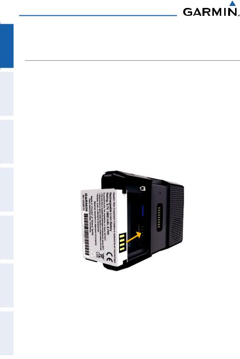
Battery Installation
Installing the battery:
1)Locate the lithium-ion battery that came in the product box.
2)Slide the release key until the battery cover on the back of the aera opens up.
3)Remove the battery cover.
4)Locate the metal contacts on the end of the lithium-ion battery.
5)Insert the battery so that the metal contacts on the battery line-up with the metal contacts inside the battery compartment.
6)Slide the top of the battery cover into the groove on the inside of the battery compartment, and press down.
Installing the Battery
2 |
Garmin aera 500 Series Quick Reference Guide |
190-01117-03 Rev. A |
|

Overview
Charging the Battery
NOTE: While in Charge Mode, the unit draws a current from the aircraft. To avoid discharging the aircraft’s battery, disconnect the external power cable
from the unit when not in use for several days.
Charging the unit’s battery using the aircraft's power outlet:
1)Mount the aera in the aircraft (refer to Appendix D of the aera 500 Series Pilot's Guide), and connect the power cable to the aircraft power outlet (cigarette lighter receptacle).
2)Route the power cable so that it does not interfere with aircraft operation. The unit begins charging as soon as external power is applied.
Changing Modes
The aera offers two modes for transportation: automotive and aviation.
Changing modes:
1)Touch the automotive or aviation icon at the top of the 'Home' Screen.
2)Touch Yes.
Aviation Automotive
Or:
1)From the 'Home' Screen, touch Tools > Automotive or Aviation (from automotive mode).
2)Touch Yes.
GPS Receiver Status
The  bars on the 'Home' Screen indicate the GPS signal strength.
Viewing the GPS status:
From the 'Home' Screen, touch Tools > GPS Status.
Utilities Avoidance Hazard Planning Flight Navigation GPS Overview
Appendix
Index
190-01117-03 Rev. A |
Garmin aera 500 Series Quick Reference Guide |
3 |
|

Utilities Hazard Avoidance Flight Planning GPS Navigation Overview
Appendix
Index
Overview
1.3 Operation
Basic Navigation Controls
The controls on the touchscreen change dynamically depending on the function displayed.
Touch the following icons to perform the associated function:
Home |
|
Returns to the ‘Home’ screen. |
Back |
|
Displays the previous page; Returns ‘Home’ (touch and hold). |
OK |
|
Commits a value edited or selected. |
Menu |
|
Displays the context sensitive option menu. |
Menu/ |
|
Displays the menu; Displays the Direct-to function (touch and hold). |
|
||
Up |
|
Scrolls up. |
Down |
|
Scrolls down. |
Direct-to Displays the Direct-to function. |
||
Out |
|
Zooms out. |
In |
|
Zooms in. |
Keypad Controls
OK |
Exits the keypad function and accepts the changes. |
BKSP |
Erases the current data. |
Numeric |
Displays the numeric only keypad. |
Alpha |
Displays the alpha and numeric keypads. |
Cancel |
Cancels a value that has been edited. |
4 |
Garmin aera 500 Series Quick Reference Guide |
190-01117-03 Rev. A |
|
Overview
‘Home’ Screen
Touch the  icon at any time to access the ‘Home’ Screen.
‘Home’ Screen Icons
Touch the following icons to perform the associated function:
Map |
Displays the Navigation Map. |
Terrain |
Displays the Terrain Map. |
HSI/Panel |
Displays the Panel Mode. |
Nearest |
Displays the second-level Nearest Icons. |
Numbers |
Displays flight data. |
Active FPL |
Displays the Active Flight Plan. |
WPT Info |
Displays the Waypoint Information. |
Direct To |
Displays the 'Direct To' function. |
Position |
Displays the aircraft's Present Position. |
Weather |
Displays second-level Weather Icons (aera 510 & 560). |
XM Radio |
Displays XM Radio (aera 510 & 560). |
Tools |
Displays second-level Tools Icons. |
Nearest Icons
From the ‘Home‘ Screen, touch the Nearest Icon to access the second-level Nearest Icons.
Touch the following icons to perform the associated function:
Airport Displays nearest airports. Airport WX Displays nearest airport weather.
VOR |
Displays nearest VORs. |
NDB |
Displays nearest NDBs. |
Utilities Avoidance Hazard Planning Flight Navigation GPS Overview
Appendix
Index
190-01117-03 Rev. A |
Garmin aera 500 Series Quick Reference Guide |
5 |
|
Utilities Hazard Avoidance Flight Planning GPS Navigation Overview
Appendix
Index
Overview
Intersection |
Displays nearest intersections. |
VRP |
Displays nearest Visual Reporting Point (VRP) (Atlantic). |
User WPT |
Displays nearest user waypoints. |
City |
Displays nearest cities. |
ARTCC |
Displays nearest ARTCCs. |
FSS |
Displays nearest Flight Service Stations (FSS). |
Airspace |
Displays nearest airspace. |
Weather Icons (aera 510 & 560)
From the ‘Home‘ Screen, touch the Weather Icon to access the second-level Weather Icons.
Touch the following second-level Icons to display the weather product on the Weather Map:
NEXRAD |
Displays NEXRAD (NEXt-generation RADar). |
Satellite |
Displays Satellite Mosaic cloud cover. |
Echo Tops |
Displays Echo Tops. |
Winds |
Displays Winds Aloft. |
Lightning |
Displays Lightning. |
Storm Cells |
Displays Storm Cells. |
METAR |
Displays METARs. |
AIRMET |
Displays AIRMETs. |
SIGMET |
Displays SIGMETs. |
TFR |
Displays TFRs (Temporary Flight Restrictions). |
PIREP |
Displays PIREPs. |
6 |
Garmin aera 500 Series Quick Reference Guide |
190-01117-03 Rev. A |
|
Overview
Freeze Lvl Displays Freezing Levels.
Turb Fcst Displays the Turbulence Forecast. Icing Fcst Displays the Icing Forecast.
WX Frst Displays Forecast Information (current, 12, 24, 36, & 48). Pressure Displays Surface Pressure.
Sea Temp Displays Water Temperature.
Tools
From the ‘Home‘ Screen, touch the Tools Icon to access the second-level Tools Icons.
Touch the following second-level icons to perform the associated function:
Setup |
Displays third-level Setup Icons. |
User WPT |
Displays User Waypoints and Proximity Waypoints. |
Flight Log |
Displays Flight Logs. |
Track Log |
Displays Track Logs. |
FPL List |
Displays the Flight Plan List. |
VNAV |
Displays Vertical Navigation. |
Profile |
Displays Aircraft Profiles. |
E6B Calc |
Displays the E6B Calculator. |
Weight/Bal |
Displays the Weight & Balance. |
Database |
Displays database and software version information. |
Automotive |
Activates automotive mode. |
GPS Status |
Displays GPS status information. |
Utilities Avoidance Hazard Planning Flight Navigation GPS Overview
Appendix
Index
190-01117-03 Rev. A |
Garmin aera 500 Series Quick Reference Guide |
7 |
|

Utilities Hazard Avoidance Flight Planning GPS Navigation Overview
Appendix
Index
Overview
Setup Icons
From the ‘Home‘ Screen, touch the Tools > Setup to access the third-level Setup Icons.
Touch the following third-level icons to perform the associated function:
Display |
Displays backlight intensity/timeout and color mode settings. |
Sound |
Displays sound settings. |
Units |
Displays unit settings. |
Date/Time |
Displays date & time settings. |
Map |
Displays Navigation Map settings. |
Position |
Displays position settings. |
Interface |
Displays interface settings. |
Alarms |
Displays alarm settings. |
SUA Alarms |
Displays Special Use Airspace alarm settings. |
Power |
Displays power settings |
Selecting a Function
Touch the desired icon. The icon will momentarily turn blue when selected.
Terrain Icon Selected (‘Home’ Screen)
8 |
Garmin aera 500 Series Quick Reference Guide |
190-01117-03 Rev. A |
|

Overview
Scrolling
Scrolling up/down on the touchscreen:
Touch the Up or Down Arrow Icons (if available).
Or:
If the arrow icons are present, touch and drag your finger up or down.
Scrolling (Weather Icons)
1.4 Accessing System Functionality
Option Menus
The aera has a dedicated Menu Icon that displays a context-sensitive list of options for the function displayed.
Navigating the option menu:
If available, touch the Menu or Menu/ Icon
Icon
Touch the Up/Down Icons if necessary to scroll through the Option Menu.
Touch the desired menu option.
Utilities Avoidance Hazard Planning Flight Navigation GPS Overview
Appendix
Index
190-01117-03 Rev. A |
Garmin aera 500 Series Quick Reference Guide |
9 |
|
Loading...