


 Loading...
Magellan® Triton™ 2000
User Manual
Magellan Navigation, Inc. 960 Overland Court, San Dimas, CA 91773
IMPORTANT SAFETY WARNINGS
The Magellan Triton is a navigation aid designed to assist you in arriving to your selected destination. When using the Magellan Triton, these safety rules must be followed to prevent accidents that can result in injury or death to yourself or others:
IN THE INTEREST OF SAFETY, DO NOT USE THIS NAVIGATION DEVICE WHILE
DRIVING A VEHICLE.
Please do not try and change any settings on the Magellan Triton while driving. Come to a complete stop or have a passenger make any changes. Taking your eyes off the road is dangerous and can result in an accident in which you or others could be injured.
USE GOOD JUDGEMENT
This product is an excellent navigation aid, but does not replace the need for careful orienteering and good judgement. Never rely solely on one device for navigating.
USE CARE
The Global Positioning System (GPS) is operated by the U.S. Government, which is solely responsible for the accuracy and maintenance of the GPS network.The accuracy of position fixes can be affected by the periodic adjustments to GPS satellites made by the U.S. government and is subject to change in accordance with the Department of Defense civil GPS user policy and the Federal Radionavigation Plan. Accuracy can also be affected by poor satellite geometry and obstructions, like buildings and large trees.
USE PROPER ACCESSORIES
Use only Magellan cables and antennas; the use of non-Magellan cables and antennas may severely degrade performance or damage the receiver, and will void the warranty.
LICENSE AGREEMENT
Magellan Navigation Inc. grants you, the purchaser, the right to use the software supplied in and with Magellan Navigation GPS products (the “SOFTWARE”) in the normal operation of the equipment.
The SOFTWARE is the property of Magellan Navigation and/or its suppliers and is protected by United States copyright laws and international treaty provisions; therefore, you must treat this SOFTWARE like any other copyright material.
You may not use, copy, modify, reverse engineer or transfer this SOFTWARE except as expressly provided in this license. All rights not expressly granted are reserved by Magellan Navigation and/or its suppliers.
Operation is subject to the following two conditions: (1) this device may not cause interference, and (2) this device must accept any interference, including interference that may cause undesired operation of this device.
No part of this guide may be reproduced or transmitted in any form or by any means, electronic or mechanical, including photocopying and recording, for any purpose other than the purchaser’s personal use without the prior written permission of Magellan Navigation Inc.
i

IMPORTANT SAFETY WARNINGS
Federal Communication Commission Interference Statement
This equipment has been tested and found to comply with the limits for a Class B digital device, pursuant to Part 15 of the FCC Rules. These limits are designed to provide reasonable protection against harmful interference in a residential installation. This equipment generates, uses and can radiate radio frequency energy and, if not installed and used in accordance with the instructions, may cause harmful interference to radio communications. However, there is no guarantee that interference will not occur in a particular installation. If this equipment does cause harmful interference to radio or television reception, which can be determined by turning the equipment off and on, the user is encouraged to try to correct the interference by one of the following measures:
•-Reorient or relocate the receiving antenna.
•-Increase the separation between the equipment and receiver.
•-Connect the equipment into an outlet on a circuit different from that to which the receiver is connected.
•-Consult the dealer or an experienced radio/TV technician for help.
This device complies with Part 15 of the FCC Rules. Operation is subject to the following two conditions: (1) This device may not cause harmful interference, and (2) this device must accept any interference received, including interference that may cause undesired operation.
FCC Caution: Any changes or modifications not expressly approved by the party responsible for compliance could void the user's authority to operate this equipment.
IMPORTANT NOTE:
FCC Radiation Exposure Statement:
This equipment complies with FCC radiation exposure limits set forth for an uncontrolled environment. End users must follow the specific operating instructions for satisfying RF exposure compliance.
This transmitter must not be co-located or operating in conjunction with any other antenna or transmitter.
In order to maintain compliance with FCC regulations, shielded cables must be used with this equipment. Operation with non-approved equipment or unshielded cables is likely to result in interference to radio and TV reception. The user is cautioned that changes and modifications made to the equipment without the approval of manufacturer could void the user's authority to operate this equipment.
The Magellan Triton must be installed and operated at a distance no closer then 8 inches (20 cm) from the user.
This Class B digital apparatus meets all requirements of the Canadian Interference-Causing Equipment Regulations.
Cet appareil numerique de la classe B respecte toutes les exigences du Reglement sur le materiel brouilleur du Canada.
ii
IMPORTANT SAFETY WARNINGS
IC statement
Operation is subject to the following two conditions:
1.This device may not cause interference and
2.This device must accept any interference, including interference that may cause undesired operation of the device.
IMPORTANT NOTE:
IC Radiation Exposure Statement:
This equipment complies with IC radiation exposure limits set forth for an uncontrolled environment. End users must follow the specific operating instructions for satisfying RF exposure compliance.
This transmitter must not be co-located or operating in conjunction with any other antenna or transmitter.
The information provided in this document is subject to change without notice. Improvements and enhancements to the product may occur without any formal notification. Check the Magellan website (www.magellanGPS) for product updates and additional information.
Underwriters Laboratories Inc. (“UL”) has not tested the performance or reliability of the Global Positioning System (“GPS”) hardware, operating software or other aspects of this product. UL has only tested for fire, shock or casualties as outlined in UL’s Standard(s) for Safety for Information Technology Equipment, UL60950-1. UL Certification does not cover the performance or reliability of the GPS hardware and GPS operating software. UL MAKES NO REPRESENTATIONS, WARRANTIES OR CERTIFICATIONS WHATSOEVER REGARDING THE PERFORMANCE OR RELIABILITY OF ANY GPS RELATED FUNCTIONS OF THIS PRODUCT.
Maximum. normal use temperature is 66°C.
This device is a Class 1 LED PRODUCT.
© 2007 Magellan Navigation, Inc. All rights reserved. The Magellan Logo, Magellan, and Magellan Triton are trademarks of Magellan Navigation, Inc. No part of this user manual may be reproduced or transmitted in any form or by any means, electronic or mechanical, including photocopying and recording, for any purpose other than the purchaser’s personal use, without the prior written permission of Magellan Navigation, Inc.
631483-01 A
iii

Table of Contents
Table of Contents .................................................................................................................... |
1 |
Fundamentals .......................................................................................................................... |
1 |
Navigation Screens ................................................................................................................. |
3 |
Map Screen Overview ............................................................................................. |
3 |
Buttons .......................................................................................................................... |
4 |
Cursors .......................................................................................................................... |
4 |
Navigation Fields ............................................................................................................ |
4 |
Displaying Navigation Fields ............................................................................... |
4 |
Changing a Navigation Field ............................................................................... |
5 |
Additional Navigation Screens ................................................................................. |
6 |
Accessing the Navigation Screens ....................................................................... |
6 |
Current Location Screen ................................................................................................. |
6 |
Large Data Screen .......................................................................................................... |
6 |
Changing a Navigation Field ............................................................................... |
6 |
Speedometer Screen ...................................................................................................... |
7 |
Resetting the Odometer or Maximum Speed ......................................................... |
7 |
Compass Screen ............................................................................................................ |
7 |
Changing a Navigation Field ............................................................................... |
7 |
Calibrating the Electronic Compass ..................................................................... |
7 |
Calibrating the True North .................................................................................. |
7 |
Viewing the Compass, Temperature and Pressure Sensor Statistics ......................... |
7 |
Satellite Status ................................................................................................................ |
8 |
Changing a Navigation Field ............................................................................... |
8 |
Using the Keypad .................................................................................................................... |
9 |
The Keypad ........................................................................................................... |
9 |
Key Functions ................................................................................................... |
9 |
Create Menu ......................................................................................................................... |
10 |
Accessing the Create Menu ............................................................................... |
10 |
Waypoints .................................................................................................................... |
10 |
Creating a Waypoint ......................................................................................... |
10 |
Trail ............................................................................................................................. |
11 |
Creating a Trail from Current Track History ......................................................... |
11 |
Geocache ..................................................................................................................... |
11 |
Creating a Geocache Waypoint .......................................................................... |
11 |
Table of Contents |
Magellan Triton 2000 |
1 |
Route ........................................................................................................................... |
12 |
Creating a Route .............................................................................................. |
12 |
Go To Menu .......................................................................................................................... |
14 |
Accessing the Go To Menu ............................................................................... |
14 |
Waypoints .................................................................................................................... |
14 |
Go To a Waypoint ............................................................................................ |
14 |
Editing a Waypoint .......................................................................................... |
14 |
Deleting a Waypoint ......................................................................................... |
15 |
Duplicating a Waypoint .................................................................................... |
15 |
Places .......................................................................................................................... |
15 |
Creating a Go To to a Place .............................................................................. |
15 |
Trail ............................................................................................................................. |
16 |
Activating a Trail ............................................................................................. |
16 |
Deleting a Trail ................................................................................................ |
16 |
Duplicating a Trail ........................................................................................... |
17 |
Geocache ..................................................................................................................... |
17 |
Creating a Geocache Go To ............................................................................... |
17 |
Deleting a Geocache Waypoint .......................................................................... |
18 |
Duplicating a Geocache .................................................................................... |
18 |
Route ........................................................................................................................... |
19 |
Activating a Route ........................................................................................... |
19 |
Editing a Route ............................................................................................... |
19 |
Duplicating a Route ......................................................................................... |
19 |
Deleting a Route .............................................................................................. |
19 |
View Menu ............................................................................................................................ |
21 |
Local Info ............................................................................................................ |
21 |
Viewing Best Fishing and Hunting Times for Current Location .............................. |
21 |
Viewing Sunrise, Sunset Times and Lunar Information for Current Location ........... |
21 |
User Profiles ........................................................................................................ |
22 |
Activating User Profiles .................................................................................... |
22 |
Display options ................................................................................................ |
22 |
Map options .................................................................................................... |
23 |
Navigation options ........................................................................................... |
23 |
Alert options ................................................................................................... |
23 |
Tracks ................................................................................................................. |
24 |
Viewing Track Vertical Profile ............................................................................ |
24 |
Saving a Track as a Trail .................................................................................. |
24 |
Erasing a Track ............................................................................................... |
25 |
Table of Contents |
Magellan Triton 2000 |
2 |
Setting Track Log Options ................................................................................ |
25 |
Maps .................................................................................................................. |
25 |
Viewing Map Information .................................................................................. |
25 |
Media ................................................................................................................. |
25 |
Viewing Stored Media ...................................................................................... |
25 |
Settings .............................................................................................................. |
26 |
Navigation .................................................................................................................... |
26 |
Setting Navigation Options ............................................................................... |
26 |
Volume & Brightness .................................................................................................... |
26 |
Setting Volume & Brightness ............................................................................ |
26 |
Memory ........................................................................................................................ |
26 |
View Memory Usage ......................................................................................... |
26 |
Clearing Memory ............................................................................................. |
26 |
Restoring Factory Settings ................................................................................ |
27 |
Formatting SD Card ......................................................................................... |
27 |
About ........................................................................................................................... |
27 |
Displaying Information About the Triton Receiver ................................................ |
27 |
Diagnostics ................................................................................................................... |
27 |
Testing the touchscreen display ........................................................................ |
27 |
Table of Contents |
Magellan Triton 2000 |
3 |

Fundamentals
The Magellan Triton is a hand-held GPS receiver that has been designed for the outdoorsman. Simple to use, yet powerful enough to get you through the toughest terrain or returning to that same fishing hotspot, year after year.
•Store waypoints that can include images for the complete experience.
•Record your track from start to finish and save it as a trail to be used over and over.
•Set a quick and easy Go To route from your current position to a stored waypoint or any point on the map, simply and easily.
•Built-in flashlight to light your way in the dark.
•Load detailed Magellan maps with topographic or navaid information for the most detail possible.
•Alarms can be set to alert you when you are nearing your destination, drifted off-course, your boat has drifted from its anchor point as well as other alarms for a wide variety of choices.
•View images stored on an SD card that can be used to assist you in arriving at the proper location.
•Create a route from your current position to many different waypoints or places on the map. Plan your day for the best use of your outdoor time.
The Magellan Triton is constantly being reviewed and updated to meet the outdoorsman’s needs. Be sure to visit the support page at www.magellanGPS.com for firmware updates, keeping your Magellan Triton running at it’s peak.
While you are checking for firmware updates, check the support section for additional FAQs as well as updated manuals to assist you in the use of your Magellan Triton.
This document is set up to be printed on 8.5” x 11” (letter) paper should you desire a printed version for your reference.
Fundamentals |
1 |
D O
O
A
L
B
M
C F I N
K
G J
H
E
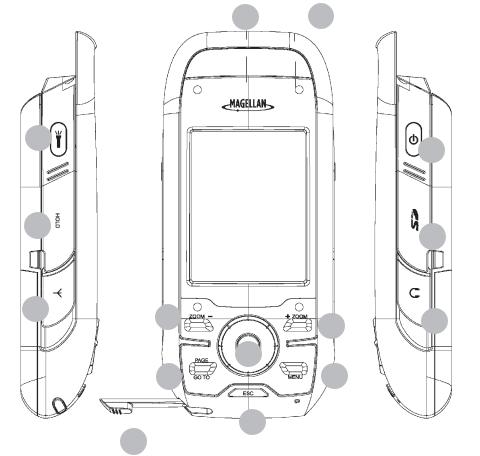
ABacklight / Flashlight button. Press to step though 3 levels of backlight intensity or off. Press and hold for 2-3 seconds to turn the flashlight on or off.
BHold Switch. Slide up to place the Magellan Triton in hold mode. During hold mode, the keys will not function, preventing accidental use.
CConnector for optional external antenna
DFlashlight
EStylus
FZoom out button
GPage / Go To. Press to step through the navigation screens. Press and hold for 2- 3 seconds to access the Go To function quickly.
H Escape or cancel button
IZoom in button
JMenu button. On the map screen, displays the Main Menu. On other screens, displays a pop-up menu when available.
K Enter button and cursor control pad
L On / Off button
MSD card slot
N Headphone connector (headphone is an optional accessory)
OReset
Fundamentals |
2 |
Navigation Screens
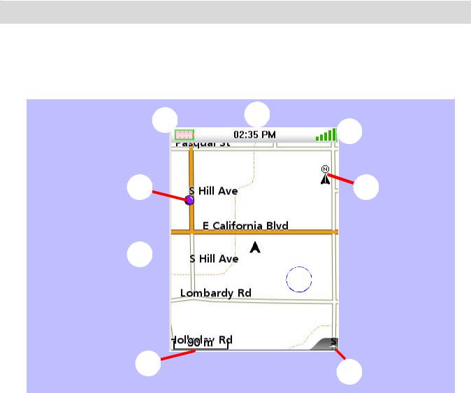
The Map Screen will be the most commonly viewed screen while using the Magellan Triton. It has been simplified to provide the best possible outdoor experience while providing access to all of the information needed at the touch of a finger.
Map Screen Overview
A H
G
B 
 F
F
C 

I
D 
 E
E
ABattery Level
BSaved Waypoint (Preloaded or User-Entered)
CPresent Position Marker (points towards heading while moving)
DMap Scale Indicator
EOptional Navigation Field pop-up
FNorth Indicator
GSatellite Status
HTime of Day
IMap Area (touch and move to pan around the map)
Navigation Screens |
3 |
Loading...