


Magellan RoadMate
User Manual
2016-2017
IMPORTANT SAFETY WARNINGS
The Magellan RoadMate receiver is a vehiclenavigation aid designed to assist you in arriving at your selected destinations. When using
the Magellan RoadMate receiver, these safety rules must be followed to prevent accidents that can result in injury or death to yourself or others:
Please check the applicable regulations in your state regarding windshield mounting. Certain states prohibit the mounting of any items on your windshield. Go to www.magellanGPS.com for alternative mounting solutions.
When driving, the need to view the display is minimal. Voice prompts will guide you to your destination. The driver should enter data or program the Magellan RoadMate receiver only when the vehicle is stationary. Only a vehicle passenger should enter data or program the Magellan RoadMate receiver while the vehicle is moving. Do not become distracted by the receiver while driving, and always be fully aware of all driving conditions.
It is your responsibility to comply with all traffic laws and to use the Magellan RoadMate and mounting options in such a manner that the user is in compliance with applicable laws.
Roads, points of interest (POIs), business and service locations may change over time. As a result the database may contain inaccuracy. Also, the database does not include, analyze, process, consider, or reflect any of the following: legal restrictions (such as vehicle type, weight, height, width, load and speed restrictions); road slope or
gradient; bridge height, width, weight or other limits; population density; neighborhood quality or safety; availability or proximity of police, emergency rescue, medical or other assistance; construction work zones or hazards; road or lane closures; road, traffic or traffic facilities’ safety or condition; weather conditions; pavement characteristics or conditions; special events; traffic congestion. It is your responsibility to disregard any unsafe, hazardous or illegal route suggestions.
Keep the Magellan RoadMate receiver safe from extreme temperature conditions. For example, do not leave it exposed to direct sunlight for an extended period of time.
Take care when mounting the Magellan RoadMate receiver in your vehicle, whether using the windshield mount or other mounts, that it does not obstruct the driver’s view of the road, interfere with the operation of the vehicle’s safety devices such as air bags, or present a hazard to occupants of the vehicle should the receiver be dislodged while driving. It is your responsibility to assess the risks associated with damage to your vehicle or vehicle occupants as the result of your choices in mounting the Magellan RoadMate receiver.
Temperature
The maximum operating temperature is 140°F (60°C).
Battery
The battery in the Magellan RoadMate receiver is rechargeable and should not be removed. In the event that it should need to be replaced, please contact Magellan Technical Support.
Charging the Magellan RoadMate
An optional AC adapter is available as an accessory for your Magellan RoadMate. Use of another type of AC adapter can result in malfunction and/or possible fire hazard due to battery overheating.
Only use the car charger approved for/supplied with your Magellan RoadMate receiver. Use of another type of car charger will result in fire or electric shock.
For safety reasons, the battery in your Magellan RoadMate receiver will stop charging when the ambient temperature is less than 32°F (0°C) or more than 113°F (45°C).
It will take approximately 4 hours of charging the Magellan RoadMate receiver through the vehicle power adapter or optional AC adapter to obtain a full battery charge. It is

recommended that you charge the battery initially for at least 2 hours.
Use only the charger approved for your Magellan RoadMate receiver.
Estimated usage of the Magellan RoadMate on battery power is approximately 2 hours.
Federal Communication Commission Interference Statement
This equipment has been tested and found to comply with the limits for class B digital devices, in accordance with part 15 of the FCC Rules. These limits are designed to
provide reasonable protection against harmful interference in a residential installation.
This equipment generates, uses and can radiate radio frequency energy and, if not installed and used in accordance with the instructions, may cause harmful interference to radio communications. However, there is no guarantee that interference will not occur in a particular installation. If this equipment does cause harmful interference to radio or television reception, which can be determined by turning the equipment off and on, the user is encouraged to try to correct the interference by one of the following measures:
Reorient or relocate the receiving antenna.
Increase the separation between the equipment and receiver.
Connect the equipment into an outlet on a circuit different from that to which the receiver is connected.
Consult the dealer or an experienced radio/TV technician for help.
This device complies with Part 15 of the FCC Rules. Operation is subject to the following two conditions: (1) This device may not cause harmful interference, and (2) this device must accept any interference received, including interference that may cause undesired operation.
FCC Caution: Any changes or modifications not expressly approved by the party responsible for compliance could void the user’s authority to operate this equipment.
IMPORTANT NOTE:
FCC Radiation Exposure Statement:
This equipment complies with FCC radiation exposure limits set forth for an uncontrolled environment. End users must follow the specific operating instructions for satisfying RF exposure compliance.
This transmitter must not be co-located or operating in conjunction with any other antenna or transmitter.
In order to maintain compliance with FCC regulations, shielded cables must be used with this equipment. Operation with non-approved equipment or unshielded cables is likely to result in interference to radio and TV reception. The user is cautioned that changes and modifications made to the equipment without the approval of manufacturer could void the user’s authority to operate this equipment.
Magellan RoadMate
Tested To Comply
With FCC Standards
FOR HOME OR OFFICE USE
The Magellan RoadMate receiver must be installed and operated at a distance no closer then 8 inches (20 cm) from the user.
This Class B digital apparatus meets all requirements of the Canadian InterferenceCausing Equipment Regulations.
IC statement
This device complies with Industry Canada licence-exempt RSS standard(s). Operation is subject to the following two conditions:
1.This device may not cause interference and
2.This device must accept any interference, including interference that may cause undesired operation of the device.

IMPORTANT NOTE:
IC Radiation Exposure Statement:
This equipment complies with IC radiation exposure limits established for an uncontrolled environment. End users must follow the specific operating instructions for satisfying RF exposure compliance.
This transmitter must not be co-located or operated in conjunction with any other antenna or transmitter.
One or more claims of the following patents may cover this product: U.S. patent No. 5,544,060, U.S. patent No. 5,654,892, U.S. patent No. 5,832,408 and U.S. patent No. 5,987,375
The information provided in this document is subject to change without notice. Improvements and enhancements to the product may occur without any formal notification. Check the Magellan website (www.magellanGPS.com/support) for product updates and additional information.
Canada, avis d’Industry Canada (IC)
Le présent appareil est conforme aux CNR d’Industrie Canada applicables aux appareils radio exempts de licence. L’exploitation est autorisée aux deux conditions suivantes : (1) l’appareil ne doit pas produire de brouillage, et (2) l’utilisateur de l’appareil doit accepter tout brouillage
radioélectrique subi, même si le brouillage est susceptible d’en compromettre le fonctionnement.
This user manual will give you the necessary information on how to use the various features of the Magellan RoadMate receiver.
Visit us at magellanGPS.com/support
© 2016-2017 MiTAC International Corporation. The Magellan logo, Magellan, RoadMate and Quickspell are registered trademarks of MiTAC International Corporation. SmartDetour and OneTouch are trademarks of MiTAC International Corporation and are used under license by MiTAC International Corporation. All rights reserved.
All other products and brand names are trademarks of their respective holders.
No part of this user manual may be reproduced or transmitted in any form or by any means, electronic or mechanical, including photocopying and recording, for any purpose other than the purchaser’s personal use, without the prior written permission of MiTAC International Corporation.
The information provided in this document are correct at the time that it is created.
MiTAC International Corporation assumes no responsibility or liability for any errors or inaccuracies that may appear in the contents of this User Manual.
112-0120-001
Table of Contents |
|
Magellan RoadMate GPS Receiver |
....................................................................................................6 |
Getting Started .................................................................................................................................. |
8 |
Map Screen ..................................................................................................................................... |
12 |
Selecting a Destination ................................................................................................................... |
15 |
Points of Interest (POI) .................................................................................................................... |
19 |
Traveling on a Route........................................................................................................................ |
21 |
OneTouch Menu............................................................................................................................... |
23 |
Traffic .............................................................................................................................................. |
25 |
Settings............................................................................................................................................ |
26 |
Warranty .......................................................................................................................................... |
32 |
Other Languages |
|
Français (French) ............................................................................................................................ |
33 |
Español (Spanish)............................................................................................................................ |
65 |
Deutsch (German) ........................................................................................................................... |
97 |
Italiano (Italian) ............................................................................................................................. |
129 |
Português (Portuguese)................................................................................................................ |
1 61 |
русский (Russian) ..................................................................................................................... |
1 93 |
Simplified Chinese ........................................................................................................................ |
2 25 |
Traditional Chinese ....................................................................................................................... |
2 57 |
Magellan RoadMate GPS Receiver
The Magellan® RoadMate® receiver is a vehicle navigation product that uses GPS signals from satellites to calculate your precise location and compute navigational information to guide you to your destination. Knowing its position and movement, your receiver can then overlay this information on detailed maps to provide a visual representation of your location.
With the Magellan RoadMate, you can:
•Save searches and addresses to the OneTouch™ menu for quick access to favorite destinations.
•Store your home address and quickly get routing details to your home.
•Enter and save addresses in your address book and get routing information to those addresses at any time.
•Route to an address using the QuickSpell™ and Smart City search for easy, errorless address entry.
•Route to any Point of Interest (POI) preloaded into your Magellan RoadMate receiver, including hospitals, restaurants, shopping malls, parks, and more.
•Receive navigation instructions with Voice Alerts (Text-to-Speech).
•Create a route with multiple destinations.
•View Highway Exit POIs, a list of gas stations, restaurants, hotels and auto repair shops located at nearby highway exits.
•Personalize your Magellan RoadMate receiver in the Settings menu.
•Receive traffic information to avoid delays in your travel (select models only).
Create and customize routes and settings, knowing that Magellan RoadMate will always provide cutting-edge mapping, low-power battery consumption, and secure technology for your navigation needs.
The Magellan RoadMate receiver has a built-in battery so, in most cases, you will be able to follow these instructions while reading them on your computer screen without plugging the Magellan RoadMate receiver to AC power using an optional AC power adapter.
Note: While indoors, you may not get sufficient satellite signals to compute your location,
so your location information may not be updated. However, the GPS chipset installed in the Magellan RoadMate receiver will pick up satellite signals in some very demanding locations. You may find that the Magellan RoadMate receiver will even compute a position indoors. Even with the improved GPS chipset, the receiver may not be able to always compute a fix indoors.
If you are not getting sufficient satellite signals while in a garage or other structure, move
to a location where there is a clear view of the sky, and you should immediately see an improvement in signal strength.
Thank you for using the Magellan RoadMate.
A
B
C
D
Magellan RoadMate
A Power button B Audio out
C MicroSD card slot (not available on all receivers)
Note: The microSD card allows you to access optional map regions. Visit the Magellan Online Shop for additional map regions available for your receiver.
D USB Connection
Note: Power input derives from the vehicle power adapter cable or optional AC power adapter. The USB connection is also used for connecting your receiver to a personal computer for map and software updates using the Magellan Content Manager application.
Reset
The reset button is located on the lower right corner of the back of your receiver. To reset your receiver, gently insert a paperclip into the reset hole to press the reset button with the receiver turned on. The receiver should restart with factory default settings.
Getting Started 2
Powering on the Magellan RoadMate receiver
The Power On/Off switch is located on the top of the Magellan RoadMate receiver.
Turning the Magellan RoadMate receiver On
1.Press the power switch.
2.Read and tap  after the initial splash Warnings screen is displayed.
Turning the Magellan RoadMate receiver Off
Press the power switch. The receiver will automatically power off in 15 seconds.
Cancel: Cancels the power off sequence and returns to last viewed screen.
Power Down Now: Turns the receiver off immediately, bypassing the 15 second delay.
Note: The receiver will begin the power off sequence anytime the power cable is disconnected from the receiver or power is turned off at the 12 V power receptacle.
Battery Levels
The Magellan RoadMate receiver has an internal battery that charges whenever the receiver is connected to external power.
Note: The battery can only be serviced by authorized Magellan repair facilities.
Viewing the Battery Level Indicator
1.Tap on the Menu button in the right corner of the Map screen.
2.The battery level indicator is located in the upper right corner of the Main Menu, just below the satellite signal indicator. Green bars indicate battery level.
Speaker Volume
Changing the Volume from the Map Screen
1. Tap  . Additional controls appear.
2.Tap the speaker button to mute the volume, or tap the + or - buttons to raise or lower the volume.
3.Tap  .
.
Changing the Volume from Settings
1. Access the Main Menu.
2. Tap |
. |
3.Tap Sound.
4.Tap inside the Master volume adjust bar to change the volume level of your RoadMate receiver.
5.Tap  to save and exit.
Setting Button Sounds On or Off
1.Access the Main Menu.
2.Tap  .
.
3.Tap Sound.
4.Tap the check box for Button Sounds to
play (checked) or turn off (unchecked) button sounds.
Setting Smart Volume On or Off
The Smart Volume feature changes the receiver volume automatically as your speed changes to compensate for road noise.
1.Access the Main Menu.
2.Tap  .
.
3.Tap Sound.
4.Tap the Smart Volume check box to turn on (checked) or turn off (unchecked) this feature.
Brightness
Accessing the Brightness Control
1.Access the Main Menu.
2.Tap  .
.
3.Tap Brightness.
4.Slide the brightness adjust bar to set the desired brightness.
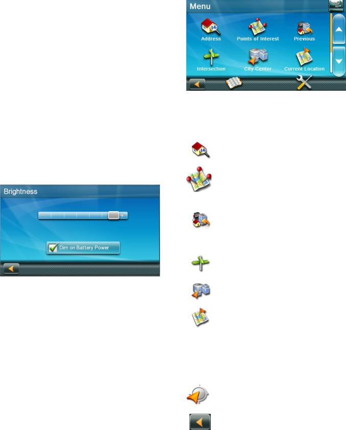
Note: A Dim on Battery Power option, when checked, will reduce screen brightness when operating exclusively on battery power and you haven’t touched the screen for a few seconds. This prolongs battery life between charges.
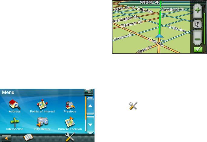
Main Menu
The Main Menu screen is the RoadMate’s central hub of activity, containing icons for all of the receiver’s major functions.
Accessing the Main Menu
Tap Menu from the Map screen to access:
|
Address |
Enter an address as a |
|
|
|
route destination. |
|
|
|
|
|
|
Points of |
Select a Point of |
|
|
Interest |
Interest (POI) from |
|
|
|
a list of preloaded |
|
|
|
locations as a |
|
|
|
destination. |
|
|
Previous |
List of your most |
|
|
|
recently visited |
|
|
|
destinations, allowing |
|
|
|
you to quickly select |
|
|
|
one to route to again. |
|
|
Intersection |
Create a route to an |
|
|
|
intersection of two |
|
|
|
streets. |
|
|
City Center |
Create a route to the |
|
|
|
geographical center of |
|
|
|
a city. |
|
|
Current |
Displays information |
|
|
Location |
about your position, |
|
|
|
including: |
|
|
|
• |
Street name |
|
|
• |
Names of streets |
|
|
|
around you |
|
|
• |
Lat/Long |
|
|
|
information for |
|
|
|
your position |
|
Coordinates |
Enter Coordinates for |
|
|
|
Routing. |
|
|
|
|
|
|
Back |
Access the Map screen. |
|
|
|
|
|
|
Address Book |
Access the Address |
|
|
Book to save addresses |
|
|
and destinations. |
|
Settings |
Displays Settings |
|
|
menu, which can |
|
|
be used to access |
|
|
functions for |
|
|
customizing your |
|
|
RoadMate receiver. |
|
Satellite |
Graphic display of the |
|
Status |
strength of satellite |
|
|
signals being received. |
|
Battery Level |
Graphic display of the |
|
|
current battery level. |
|
|
|
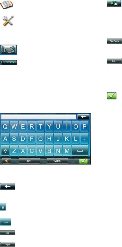
Keypad
The keypad is the most common method for entering data into your RoadMate receiver. Understanding the keypad while entering an address is important for use of your RoadMate.
|
Previous |
Previous destination |
|
|
list (Enter City only) |
|
|
When entering a city, |
|
|
this list displays cities |
|
|
previously entered. |
|
|
Tap on a city from the |
|
|
displayed list to select |
|
|
that city. |
|
Zip Code |
(Enter City only) |
|
|
Displays a numeric |
|
|
keypad to quickly enter |
|
|
a city’s zip code. |
|
List |
(Enter City only) Press |
|
|
the List button while |
|
|
entering a city to |
|
|
display a list of cities |
|
|
beginning with the |
|
|
characters you have |
|
|
entered. |
|
Accept |
(Entering City) Accepts |
|
|
the suggested city |
|
|
displayed in the data |
|
|
field. |
|
|
(Entering street) |
|
|
Displays a list of |
|
|
streets beginning with |
|
|
the characters entered. |
Selecting From List
When a list of items found in the database are displayed, use the arrows on the right to move the list up and down and tap on the desired item in the list to continue.
Keypad Overview
|
Backspace |
Moves the cursor one |
|
|
position backwards, or |
|
|
deletes the preceding |
|
|
character. |
|
Shift |
Shifts between |
|
|
uppercase and |
|
|
lowercase characters. |
|
Space |
Inserts a space at the |
|
|
cursor position. |
|
|
|
|
Numeric |
Displays a numeric |
|
|
keypad. |
|
|
|
|
Symbols |
Displays available |
|
|
symbols. |
|
|
|
Selecting QWERTY or ABC Keyboard
1.Access the Main Menu.
2.Tap  .
.
3.Tap Keyboard.
4.Select QWERTY or ABC.
Notes on Entering Data
If you have trouble getting desired results, follow these tips:
•Check to see if the name of a location contains apostrophes and hyphens if you do not see the POI or street name you are looking for in the list.
•The more characters you enter, the smaller the list of possible options is from which to choose.
•You cannot use accented letters when entering a street or city name. You can enter city and streets names using only standard characters.
QuickSpell
As letters are entered for a city or street, the Quickspell feature checks the database for cities or streets that begin with the letters entered. Any letters that cannot be used to spell a city or street name are greyed out.
Smart City Search
The Smart City Search feature attempts to predict the city you are looking for based on your position and cities you’ve gone to before.
Whenever entering or searching for an address, the Enter City Name keyboard is displayed first.
As letters are entered, Quickspell checks the database for cities beginning with the letters entered. Keys that don’t spell a city in the database are greyed out, and Smart City Search displays a suggested city in the text field.
Tap the  button to continue when the city is correct.
Tapping the  button displays a list of cities that begin with the letters entered.
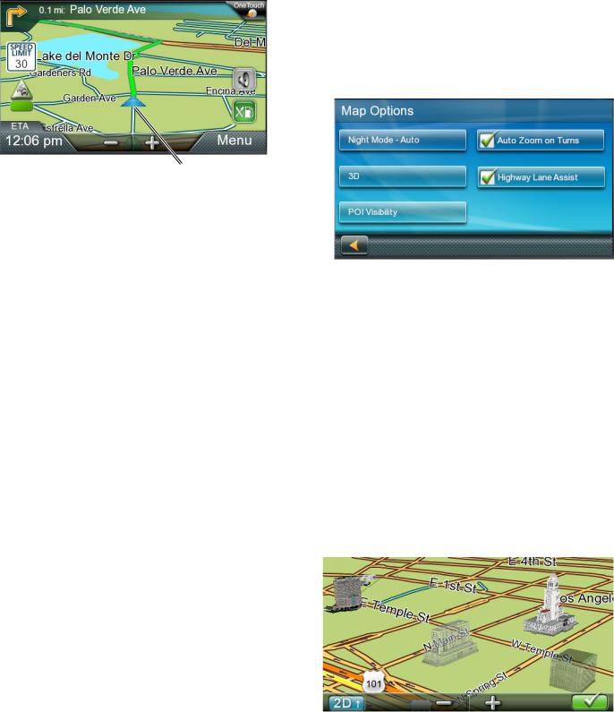
Map Screen 3
The Map screen is often used when you’re following a route or just traveling around a city, and will likely be displayed in one of two unique modes: normal and routing.
B |
I |
C |
|
|
H |
|
G |
D |
F |
E |
A |
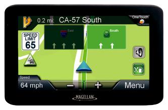
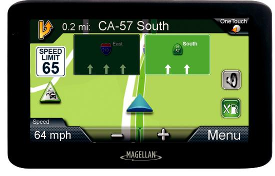
A Your Current Location
B Turn instructions for next maneuver
Tap to display the maneuver list (available only when routing). Distance and road name for the next maneuver. Tap to repeat last voice instruction.
C Speed limit
D Information Display
Displays speed, time of day, elevation, compass direction. While routing, it can also display distance to destination, estimated time of arrival (ETA), and time remaining. Tap on the information field to change.
E Zoom in/out
F Access Main Menu
G Access list of Highway Exit POIs Available only while on a highway/freeway. H Access Volume controls
I Access One Touch menu
Provides instant access to your saved search criteria and favorite destinations.
Your position and the time are shown on the map. As you travel, your position is updated, giving you a clear view of your position and surrounding streets.
Setting the Map Options
You can customize your map display preferences in Settings.
1.Tap Menu from the Map screen.
2.Tap  .
.
3.Tap the Map button.
4.Use the Map Options screen to customize your map/display preferences.
Setting the Map Modes (2D or 3D)
The map is normally displayed in 3D mode. To set the map to 2D mode:
1.Tap anywhere on the Map screen. Additional controls appear.
2.Tap 2D to switch the map to 2D mode from 3D mode, or tap 3D to switch the map to 3D mode from 2D mode.
3.Tap  .
.
3D Landmarks
3D Landmarks offer visualization for architectural landmarks.
Setting Zoom Levels
As you zoom out in 3D, the display will switch to 2D at higher zoom levels.
Tap + or - at the bottom of the Map screen to set the desired zoom level.
Note: Zoom levels are limited in 3D mode.
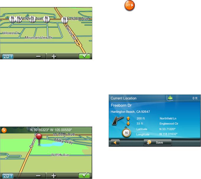
Panning on the Map
1.Slide your finger or a stylus across the Map screen. The map screen changes to Pan mode.
2.Tap  when you’re finished, and the map returns to your current position.
Routing to a Panned Position
1.Pan the map until the location you want to route to is displayed.
2.Tap on the map at the point you want to go to. A red push pin, along with information about the point chosen, will be displayed at the top of the screen.
3. Tap  in the top left corner.
4.Define what to do with this new route point if an active route already exists:
Replace Destination: The next destination is cleared and replaced with the one selected from the Pan screen.
Go There Now: The selected location is inserted in the route as an intermediate destination before the next destination.
Add To Trip: the selected destination is added to the end of the current trip.
5. Tap to return to the Map screen and begin navigating.
Note: If the selected position doesn’t match an existing street address (i.e. the destination is not along a road or street that is stored in the map database), you will be stopped on the road closest to your destination, and a dashed line to your final destination will be displayed on the map.
Current Location Screen
The Current Location screen displays the approximate address of your current position, the next and previous intersections, your latitude, longitude, heading and elevation.
Accessing the Current Location Screen
Tap the Current Position icon from the Map screen.
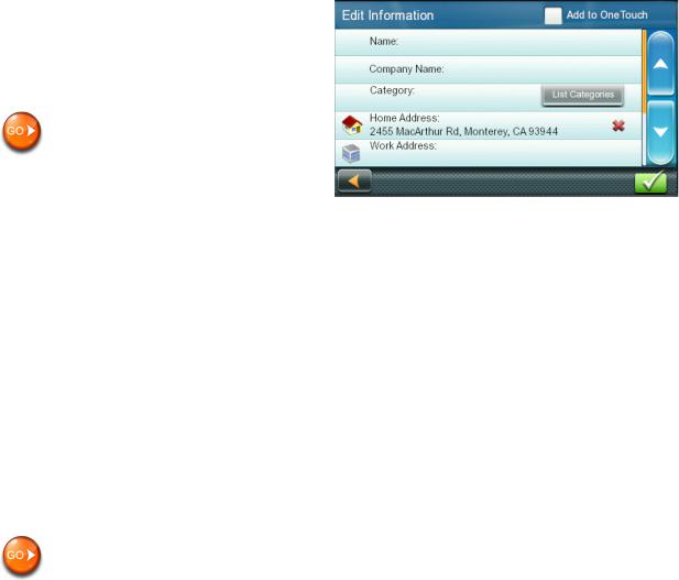
Saving Your Current Location to Your Address Book
1.Tap on the Current Position icon from the Map screen.
2.Tap Save.
3.Edit information.
Note: If you want to save this location to the OneTouch menu and the address book, check the Add to OneTouch box.
4.Tap the Name field and use the keypad to enter a name for the Address Book entry.
Note: Tap List Categories to select a category for this address. New categories can be added from the Select Category from List screen by tapping +Add.
5.Tap  to confirm address details.
6.Assign this entry to a button for your OneTouch menu if you saved this point to the OneTouch menu.
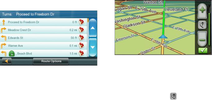
Maneuver List (Itinerary)
The Maneuver List is accessed from the Map screen, and is available only when routing.
Each line in the Maneuver List provides details about the maneuvers in the order that they are to be made, with the next maneuver at the top.
Accessing the Maneuver List
Tap the Maneuver icon in the top left corner of the Map screen when actively on a route.
Avoiding a Maneuver
This feature modifies the route to possibly avoid a particular maneuver.
1.Access the Maneuver List.
2.Tap  next to the maneuver you want to avoid.
3.Tap Yes to confirm. The Magellan RoadMate receiver recalculates the route and returns you to the Map screen.
Changing Route Options
You can change how a route is computed by Fastest Time, Shortest Distance, Mostly Freeways, or Least Use of Freeways.
1.Access the Maneuver List.
2.Tap Route Options. The four types of routes are displayed with the computed time.
3.Tap on the desired route option.
4.Tap  to begin routing.
Volume
You can adjust or mute the volume from the Map screen or from  > Sound.
Changing the Volume from the Map Screen
1. Tap  . Additional controls appear.
2.Tap on the Speaker button to mute the volume, or tap + or - icons to change the volume levels.
3.Tap  .
.
When muted, a red line appears across
the speaker icon. Tap |
again to unmute |
the volume. |
|

Selecting a Destination 4
Creating a Destination to an Address
To begin creating an address, enter the city by:
•entering the name of the city
•entering the ZIP code for the city
•selecting a previously used city.
1.Tap  from the Main Menu.
2.Enter City:
You can do this in three ways:
Tap  to select the city from the list of previous cities.
Use the keyboard to enter the first few characters of any significant word in the city name to select a new city. If the city you’re searching for appears in the top field, tap on the city name or  .
.
Tap List button to bring up a list of cities that begin with the characters you entered. Tap to select the city from the list.
Tap Zip Code to switch to the numeric keyboard and enter the ZIP code. Tap to bring up a list of cities with the zip code entered.
3.Enter the Street name.
With the city selected, the keyboard will be displayed, prompting you for the street name.
Use the keyboard to enter the street name. Enter the first few characters of
any word in the street name, and tap  or continue entering characters until the list of streets is displayed.
Note: You do not need to enter accented characters.
4.Tap on the street name from the list.
5.Enter Street number:
Use the keyboard to enter the street number for the address. The range of acceptable street numbers is displayed
before you start typing. Tap  when the street number is complete.
The GO screen appears with:
•address of the selected location
•the estimated time of arrival (ETA) distance to travel
•routing method (e.g. Fastest Time).

Tap Options to change routing method. Tap  to preview the route.
6. Tap |
to begin routing on the Map |
screen. |
|
Note: To use a destination later, tap Save (before tapping GO) to save it in your Address Book or in the OneTouch menu.
Tips on Entering Addresses Quickly
•When you are entering the name of a city or a street, only characters that appear in possible search results are displayed. The other characters are grayed out.
•Tap List after a couple of letters when entering city names or street names, as items that contain the specified characters are listed.
•Search by ZIP codes to narrow the number of matching cities to (usually) four or fewer.
Intersections
Creating a Destination to an Intersection
An intersecting street can pinpoint the location when you don’t know the street number.
1.Tap  from the Main Menu.
2.Enter City. To do this:
•Use the keyboard to enter the first few characters of any significant word in the city name to enter a new city. Tap
on the city name or  if the city you are searching for appears in the top field.
•Tap Previous to select the city from the list of previous cities.
•Tap List to display a list of cities that begin with the characters you entered. Tap to select the city from the list.
•Tap Zip Code to switch to the numeric keyboard and enter the ZIP code. Tap to bring up a list of cities with this zip code.
3.Enter the Street name:
With the city selected, the keyboard will be displayed, prompting you to enter the street name.
Use the keyboard to enter the street name. Enter the first few characters of
any word in the street name and tap  or continue entering characters until the list of streets is displayed.
Note: You do not need to enter accented characters.
Tap on the street name from the list.
4.Enter the second street name the same way as you entered the first street.
A screen appears with:
•address of the selected location
•estimated time of arrival (ETA)
•distance to travel
•routing method (e.g. Fastest Time).
Note: Tap Options to change the routing method.
5. Tap |
to begin routing on the Map |
screen. |
|
City Centers
Creating a Destination to a City Center
City Center lets you select any city on the map as your destination, which is useful when
you want to go to a city without selecting any specific address.
Note: A route to a city center uses the geographical center of the city as the destination point.
1.Tap  from the Main Menu.
2.Enter City:
Tap Previous to select the city from the list of previous cities.
Use the keyboard to enter the first few characters of any significant word in the city name to select a new city. If the city you are searching for appears in the top field, tap on the city name or  .
.
Tap on the List button to access a list of cities that begin with the characters you entered. Tap to select a city from the list.
Tap the Zip Code button to switch to the numeric keyboard and enter the ZIP code. Tap to bring up a list of cities with the zip code entered.
A screen appears with:
•address of the selected location
•estimated time of arrival (ETA)
•distance to travel
•routing method (e.g. Fastest Time).
Note: Tap Options to change the routing method.
3. Tap |
to begin navigating on the Map |
screen. |
|
Previous Destinations
Routing to a Previous Destination
1.Tap  from the Main Menu.
2.Select a destination from the list of previous destinations.
A screen appears with:
•address of the selected location
•estimated time of arrival (ETA)
•distance to travel
•routing method (e.g. Fastest).
Note: Tap Options to change the routing method.
3. Tap |
to begin navigating on the Map |
screen. |
|
Clearing the list of Previous Destinations
1.Access the list of Previous Destinations.
2.Tap Delete All.
3.Tap Yes to confirm the deletion and clear the list.
Address Book
Saving a Destination to Your Address Book
Whenever you create a destination, you can save the destination to your address book before beginning the route.
1.Tap Save on the Go screen.
2.Select Add to OneTouch when the Edit Information screen is displayed to save this location to the OneTouch menu.
Edit information:
Tap the Name field and use the keyboard to enter a name for the address book entry.
Tap Work, Cell or Home phone to specify a phone number for the address book entry.
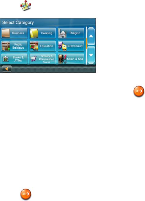
Tap List Categories to display a list of categories you’ve created for your
address book. If necessary, create a new category by tapping + Add at the bottom of the screen.
3.Tap  to confirm the details for this address.
To save this to the OneTouch menu, you will be asked to assign it to a OneTouch button.
Accessing an Address in Your Address Book
1.Tap  from the Main Menu.
2.Tap the top left corner of the screen to easily find the desired address by
narrowing the list by the first letter of the address book entries.

Routing to an Address in Your Address Book
1.Access the address record from your address book.
2. Tap on the desired address book entry. A screen appears with:
•address of the selected location
•estimated time of arrival (ETA)
•distance to travel
•routing method (e.g. Fastest Time).
Note: Tap Options to change the routing method.
3. Tap |
to begin navigating on the Map |
screen. |
|
Points of Interest (POI) 5
The RoadMate receiver has preloaded POIs, such as restaurants and gas stations, that can be used as destinations for routes.
Creating a Route to a POI by Category
POIs are categorized into unique categories like gas stations and tourist attractions. Most categories are further organized into
subcategories. Restaurants, for example, have several subcategories for Chinese food, fast food, or other favorites.
1. Tap |
from the Main Menu. |
2. Tap one of the POI categories in the list.
3.Tap one of the POI subcategories (if any) in the list to narrow the search. POIs near your current position are displayed.
4.Tap Near... for different search criteria (Near Current Position, City, or Address).
Enter city or address information when you select Near City or Near Address.
5.Select the desired POI from the POIs list. The GO screen appears with:
• address of the selected location
• estimated time of arrival (ETA)
• distance to travel
• routing method (e.g. Fastest Time).
6.Tap Options to change the routing method (Fastest Time, Shortest Distance, Mostly Freeways, or Least Use of Freeways).
7. Tap to begin navigating to the selected POI on the Map screen.
Creating a Route to a POI by Name
1.Tap  from the Main Menu.
2.Tap Search By Name.
3.Enter the name of the POI to be used as
the destination and tap  . POIs near your current position are displayed
Note: Enter as many characters as possible to make it easier to find the exact POI you are searching for.
4.Tap Near for different search criteria (Near Current Position, City, or Address).
Enter city or address information when you select Near City or Near Address.
5.Select the desired POI from the POIs list. The GO screen appears with
• address of the selected location
• estimated time of arrival (ETA)
• distance to travel
• routing method (e.g. Fastest Time).
6.Tap Options to change the routing method.
7. Tap |
to begin navigating on the Map |
screen. |
|
Creating a Route to a Highway Exit POI
The Highway Exit POIs function lets you access commonly used POIs near an exit you’re approaching while travelling on a highway, such as restaurants, gas stations, car repair facilities and hotels.
Freeway Exit POIs can be accessed while on a route or just driving, as long as you are on a freeway.
1.Tap Highway Exit POIs when it appears on the Map screen. A list of upcoming freeway exits and their distance from your current position appears.
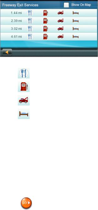
Symbols represent service POIs near the exits:
Restaurants
Gas Stations
Car Repair
Accommodations
2.Tap a symbol to get a list of related POIs near the exit.
3.Select a POI from the list, and tap  . The GO screen appears with
• address of the selected POI
• estimated time of arrival (ETA)
• distance to travel
• routing method.
4.Tap Options to change the routing method.
5. Tap to begin navigating to the selected POI on the Map screen.
Traveling on a Route 6
Map Screen
A route is displayed on the Map screen in green with small arrows indicating direction of travel once the route has been calculated.
The name of the next street in your Turn List as well as its distance is displayed on the top of the screen. If you are not in the same city as the next street, the name of that city is displayed instead.
As the route progresses, voice alerts will be used to prompt you of upcoming maneuvers.
Maneuver List
The Maneuver List displays all maneuvers along your route until your chosen destination.
Tap on the Maneuver icon in the top left corner of the Map screen to view the Maneuver List.
Accessing the Maneuver List
Tap the Maneuver icon in the top left corner of the Map screen when you’re actively following a route.
Excluding a Maneuver
You can modify the route to possibly avoid a particular maneuver.
1.Access the Maneuver List.
2.Tap  for the maneuver you want to avoid.
3.Tap Yes to confirm.
The RoadMate receiver recalculates the route and returns you to the Map screen.
Types of Routes
You can use a wide variety of methods to create a route.
Routing Method
Fastest Time (Fast): the fastest possible route provided the vehicle is able to travel at or near the speed limit.
Shortest Distance (Short): the shortest possible route.
Mostly Freeways: the route that uses freeways whenever possible.
Least Use of Freeways: the route that avoids freeways whenever possible.
When a destination is selected, the RoadMate offers the route with the default selected routing method first.
Changing the Routing Method
To change the routing method, tap Options on the GO screen. The RoadMate calculates the route with different methods.
1.Tap on the Maneuver List for the route method desired.
2.Tap the desired routing method in the list, and the previous screen returns with the new calculation.
To Change the Default Routing Method
1.Tap  from the Main Menu.
2.Tap Navigation Preferences.
3.Select a default routing method using the Route Method drop-down menu.
Special Routing Functions
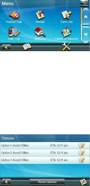
Cancelling a Route
1.Tap Menu from the Map screen.
2.Tap Cancel Trip on the Main Menu.
3.Tap Yes to confirm that you want to cancel the route.
OR
4.Tap the OneTouch icon from the Map screen to display the OneTouch menu.
5.Tap Cancel Trip.
6.Tap Yes to confirm that you want to cancel the route.
Detouring off a Route
1.Tap Menu from the Map screen.
2.Tap  .
.
Different detours are calculated using the same routing method that was used to create the route. The list of alternate routes is displayed.
3.Tap the button on the right to check the Maneuver List of an alternate route.
4.Tap the desired alternate route.
OneTouch Menu 7
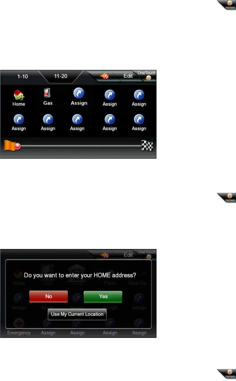
The OneTouch™ menu provides quick access to your home address, emergency services, gas stations, and addresses or searches stored in the OneTouch menu.
Accessing the OneTouch Menu
Tap the OneTouch icon in the upper right corner of the Map screen.
The Home Button
Tap the Home icon.
If you have a Home Address saved, the receiver will give you information to navigate to your home.
If you do not have a Home Address saved, you will be prompted to enter one:
Tap Yes to enter your home address using the Enter Address keyboard.
Tap Use My Current Location to make your current location your Home.
Note: To edit or delete your Home address, go to the Address Book in the Main menu and edit the Home entry.
Saving an Address to a OneTouch Icon
1. Tap in the top right corner of the Map screen. The OneTouch menu appears.
2.Tap an Assign icon.
3.Tap Location.
4.Enter the address (city, street and number) for the OneTouch icon using the keypad. When the address is complete, you are prompted to enter a name for the button.
5.Enter a name for the button using the keypad and tap  .
.
6.Go to the Map screen and access the OneTouch menu to verify that the address has been added.
Changing the Address or Search of a OneTouch Icon
1. Tap in the top right corner of the Map screen. The OneTouch menu appears.
2.Tap Edit.
3.Tap on the OneTouch button you want to edit.
4.Tap the Re-assign button.
5.Tap Yes to confirm.
6.Follow OneTouch instructions.
Saving a POI Search Criteria to a OneTouch Icon
You can also save POI search criteria to a OneTouch button for later use, as you may frequently search for coffee shops near your location or gas stations along your route.
1. Tap in the upper right corner of the Map screen.
2.Tap one of the Assign buttons.
3.Tap Search.
4.Tap one of the POI categories in the list.

5.Tap one of the POI subcategories (if any) in the list to further narrow the search, or tap All Subcategories to select all the subcategories or continue defining your search criteria.
6.Enter a name for the button using the keypad and tap  .
.
Setting a Route to a OneTouch Icon
Once you’ve set up the OneTouch menu, you can go to a saved address or search.
1.Tap the OneTouch icon in the top right corner of the Map screen.
2.Tap one of the assigned OneTouch buttons.
3.Tap on the desired POI if the assigned button is for a search and POIs are displayed.
The Preview icon at the bottom of the display allows you to step through the available POIs while viewing their location on the map.
The Near... button allows you to select how the list is sorted:
•near your current position
•near a city you define
•near an address you enter.
4. Tap |
to begin the route. |
Note: The GO screen appears whether the destination was chosen from a list of POIs or by an address.
Traffic 8
Traffic features are only available on select RoadMate models.
Glossary
RDS: Radio Data System. Infrastructure that broadcasts digital information on the FM band.
TMC: Traffic Message Channel. Type of information broadcast by a Radio Data System.
Public TMC Service: In some countries, there is at least one TMC service provider that broadcasts Traffic information free of charge. The RoadMate automatically receives public TMC services no matter which country you’re in.
For an updated list of countries and providers, visit www.magellangps.com.
Traffic Message: A message received by the RoadMate containing the description of a Traffic event.
Traffic Event: An event liable to disturb the flow of traffic.
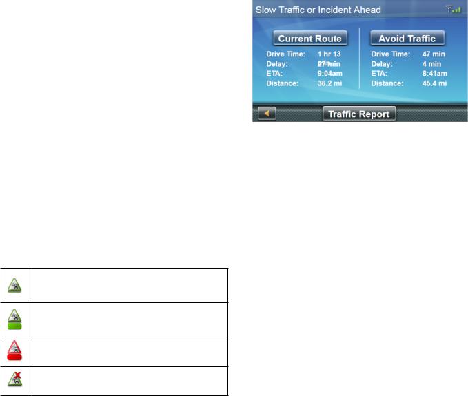
Traffic Incidents
When routing, if a traffic event (e.g. incident(s), slow traffic) will delay your arrival, the traffic icon on the Map screen will display the computed traffic delay (in minutes) in the red box below the traffic icon.
Traffic signals being received and no delay found on route.
Delay is less than 15% of entire route.
Delay is more than 15% of entire route.
No Signal indicator. Device is searching for signal.
Avoiding Traffic Incidents
You can choose to avoid traffic incidents along your route during a delay.
1.Tap on the Traffic icon while traveling on a route. The Avoid Traffic screen is displayed.
Note: The Avoid Traffic screen displays automatically when the computed delay is greater then 20% of the entire trip.
The Avoid Traffic button is active when an alternative route is available. The button is grayed out and says No Alt Route when there is no alternate route.
2.Tap Avoid Traffic. The route will be changed and the Map screen displayed.
Settings 9
User Settings allow you to customize your RoadMate receiver to your personal needs.
Note: Tapping the Back arrow from a Settings screen saves any changes you’ve made.
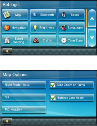
Accessing System Settings
Tap  from the Main Menu.
Map Options
Setting Auto Night Map Display
The map is normally displayed in vivid colors for daytime use, and with dark tints for night use. You can choose whether to always use daytime colors, night colors, or let the RoadMate receiver automatically switch between them right before sunrise and right after sunset.
1.Tap  from the Main Menu.
2.Tap Map.
3.Tap Night Mode to select Automatic for timed adjustment, on always, or off always.
Setting Heading Up or North Up in 2D Mode
1.Tap  from the Main Menu.
2.Tap Map.
3.Tap 3D, 2D Heading Up, or 2D North Up to toggle between settings.
Assigning Visible POIs
POI icons displayed on the map can be turned on or off to avoid visual clutter.
1.Tap  from the Main Menu.
2.Tap Map.
3.Tap POI Visibility.
4.Check POIs you want shown and unchecked POIs you want hidden on the POI Selection screen.
Setting Auto Zoom on Turns
You can set the map to automatically zoom in to the lowest level when approaching a turn.
1.Tap  from the Main Menu.
2.Tap Map.
3.Check Auto Zoom on Turns.
Setting Highway Lane Assist
When Highway Lane Assist is checked, the map displays highway signs as you approach a highway interchange, visual indicating which lane you should be in.
1.Tap  from the Main Menu.
2.Tap Map.
3.Check Highway Lane Assist.
Setting 3D Building Display
1.Tap  from the Main Menu.
2.Tap Map.
3.Check 3D Building Display.
Sound
Setting Volume from Settings
1.Tap  from the Main Menu.
2.Tap Sound.
3.Slide the volume slider bar to the desired volume level.
Turning Button Sounds On/Off
1.Tap  from the Main Menu.
2.Tap Sound.
3.Tap Button Sounds to activate (checked) or de-activate (unchecked) audible sounds when a button is tapped.
Turning Smart Volume On/Off
Smart Volume adjusts sound levels based on road noise caused by vehicle speed, which can make the speaker harder to hear.
1.Tap  from the Main Menu.
2.Tap Sound.
3.Tap Smart Volume to activate (checked) or de-activate (unchecked) Smart Volume.
Navigation
Setting The Default Route Method
1.Tap  from the Main Menu.
2.Tap Navigation Preferences.
3.Select a default routing method from the drop-down menu.
Setting The Turn Warning Alert Sounds
1.Tap  from the Main Menu.
2.Tap Navigation Preferences.
3.Select a default Turn Warning Alert sound from the drop-down menu.
Enabling Landmark Guidance
Landmark Guidance uses common landmarks when available to help you identify streets requiring a maneuver.
1.Tap  from the Main Menu.
2.Tap Navigation Preferences.
3.Check Enable Landmark Guidance to turn Landmark Guidance on.
Enabling Spoken Street Names
1.Tap  from the Main Menu.
2.Tap Navigation Preferences.
3.Check Enable Spoken Street Names to allows audible street names during navigation.
Enabling U Turn Guidance
1.Tap  from the Main Menu.
2.Tap Navigation Preferences.
3.Check Enable U Turns to allow the receiver to use U-turns during your route.
Avoiding Toll Roads
1.Tap  from the Main Menu.
2.Tap Navigation Preferences.
3.Check Avoid Toll Roads to tell the receiver to avoid toll roads whenever possible.
Safe-Driving Mode
Safe-Driving Mode is designed to encourage a safer driving experience by disabling access to high-involvement activities while you’re driving over 10 MPH. Safe-Driving Mode is automatically enabled on your receiver.
1.Tap  from the Main Menu.
2.Tap Navigation Preferences.

3.Tap Safe-Driving Mode to activate (checked) or de-activate (unchecked) Safe-Driving Mode.
Note: When you’re driving over 10 MPH while Safe-Driving Mode is enabled, the Menu button is disabled, but other features on the Map screen, such as Traffic, OneTouch, etc., are accessible.
If you attempt to access a disabled feature, a pop-up message briefly appears on your screen, reminding you to find a safe place to stop before accessing that feature.
Headlight Reminder
The Headlight Reminder alerts you to turn on your vehicle’s headlights when the receiver switches to Night Mode around sunset. The Headlight Reminder is automatically enabled on your receiver.
1.Tap  from the Main Menu.
2.Tap Navigation Preferences.
3.Tap Headlight Reminder to activate (checked) or de-activate (unchecked) the Headlight Reminder.
When the Headlight Reminder is activated, the icon appears for 15 seconds when the receiver switches to Night Mode.
You will also hear an audible alert that says “Remember to turn on your headlights!”
Note: The Headlight Reminder notification only occurs when the receiver switches from Day Mode to Night Mode.
Driving Break Reminder
The Driving Break Reminder option enables your receiver to alert you when you may need to pause after a long drive.
1.Tap  from the Main Menu.
2.Tap Navigation Preferences.
3.Move the Driving Break Reminder slider from Off (no reminder) to:
1 (reminder after 1 hour of driving)
2 (reminder after 2 hours of driving)
3 (reminder after 3 hours of driving)
4 (reminder after 4 hours of driving)
5 (reminder after 5 hours of driving)
Note: The default Driving Break Reminder option is 2 hours.
While driving, you will see the  icon for 15 seconds after your selected reminder time has elapsed from the time you turned on your receiver in your vehicle, even if you didn’t select a route.
You will also hear an audible alert saying “You have been driving for (1, 2, 3, 4, 5) hours. Consider taking a driving break.”
Note: The Driving Break Reminder countdown will restart once the icon has been displayed for 15 seconds or after turning the receiver back on from being turned off.
Brightness
Setting Brightness
1.Access the System Settings menu (above).
2.Tap Brightness.
3.Slide the Brightness slider to set the brightness of the display.
4.Tap the Back arrow.
5.Check Dim on Battery Power to dim the display while using internal battery power.
Languages
Setting Languages
1.Access the System Settings menu.
2.Tap Languages.
3.Tap the desired language.
4.Confirm the change.
5.Tap the back arrow.
Speed Warnings
Setting Speed Warning Options
1.Tap  from the Main Menu.
2.Tap Speed Warning.
3.Set Audible Warning on or off.
4.Set Visible Warning on or off. This determines if the speed limit icon is displayed on the screen.
5.Set the number of miles above the speed limit you want to receive the warnings.
Viewing the GPS Status
1.Tap  from the Main Menu.
2.Tap GPS.
3.Tap Status.
Note: You can also access the GPS Status screen by tapping on the satellite signal indicator in the upper right corner of the OneTouch screen.
Auto Power Off
Setting Auto Power Off
Auto Power is the duration of time that the Magellan RoadMate receiver automatically turns off after remaining idle.
1.Access the System Settings menu.
2.Tap Auto-Off.
3.Tap on the desired duration.
4.Tap the back arrow.
Default System Settings
Restoring All Default System Settings
1.Access the System Settings menu.
2.Tap Restore Default.
3.Confirm that you want to proceed in restoring all the system defaults.
Route Area Avoidance
Route Area Avoidance allows you to manually select an area to avoid along your route.
1.Tap  from the Main Menu.
2.Tap Route Area Avoidance.
3.Tap Add to select a new area to avoid.
Note: If you haven’t yet added any areas to avoid, Add is the only accessible option.
4.Pan around and zoom in and out of the map to select an area within the red box to avoid.
5.Tap Select to choose the areas you want to avoid, or the Back icon to cancel the action.
6.Tap Confirm on the message that appears,
Cancel Area Avoidance to cancel the selection, or the Back icon to select a different area.
The area you selected is now accessible from your Route Area Avoidance list.
Note: Your route will still include freeways and highways in the areas that you choose to avoid.
Once you’ve created one or more areas to avoid, you can:
•Edit the details of these areas.
•Add new areas to avoid.
•Select one or more areas to avoid during a route.
•Remove any of these areas from your list.
Note: You can only edit one area at a time. When you select multiple areas, the Edit function is disabled.
Product Information
Viewing Product Information
1.Tap  from the Main Menu.
2.Tap Product Information.
3.Scroll down the page to view the Serial Number and Software Version.
Magellan Limited Warranty
All Magellan global positioning system (GPS) receivers are navigation aids, and are not intended to replace other methods of navigation. The purchaser is advised to perform careful position charting and use good judgment. READ THE USER GUIDE CAREFULLY BEFORE USING THE PRODUCT.
1. MAGELLAN WARRANTY
(a)MiTAC Digital Corp. (“Magellan”) warrants its GPS receivers and hardware accessories to be free from defects in material and workmanship and will conform to its published specifications for the product for a period of one year from the date of original purchase. THIS WARRANTY APPLIES ONLY TO THE ORIGINAL CONSUMER PURCHASER OF THIS PRODUCT.
(b)In the event of a defect, Magellan will, at its discretion, repair or replace the hardware product with a product of like kind or quality, which may be new or reconditioned, with no charge to the purchaser for parts or labor. Magellan’s limit of liability under the limited warranty shall be the actual cash value of the product at the time the purchaser returns the product to Magellan for repair less a reasonable amount for usage, as determined by Magellan in its sole discretion. The repaired or replaced product will be warranted for 90 days from the date of return shipment, or for the balance of the original warranty, whichever is longer.
(c)Magellan warrants that software products or software included in hardware products will be free from defects in the media for a period of 30 days from the date of shipment and will substantially conform to the then current user documentation provided with the software (including updates thereto). Magellan’s sole obligation shall be the correction or replacement of the media or the software so that it will substantially conform to the thencurrent user documentation. Magellan does not warrant the software will meet purchaser’s requirements or that its operation will be uninterrupted, error-free or virus-free. The purchaser assumes the entire risk of using the software.
2. PURCHASER’S REMEDY
PURCHASER’S EXCLUSIVE REMEDY UNDER THIS WRITTEN WARRANTY OR ANY IMPLIED WARRANTY SHALL BE LIMITED TO THE REPAIR OR REPLACEMENT, AT MAGELLAN’S OPTION, OF ANY DEFECTIVE PART OF THE RECEIVER OR ACCESSORIES WHICH ARE COVERED BY THIS WARRANTY. REPAIRS UNDER THIS WARRANTY SHALL ONLY BE MADE AT AN AUTHORIZED MAGELLAN SERVICE CENTER. ANY REPAIRS BY A SERVICE CENTER NOT AUTHORIZED BY MAGELLAN WILL VOID THIS WARRANTY.
3. PURCHASER’S DUTIES
For repair or replacement on a Magellan product the purchaser must obtain a Return Materials Authorization (RMA) number from Magellan Technical Support or by
submitting a repair request through our website at www. magellanGPS.com, prior to shipping. The purchaser must return the product postpaid with a copy of the original sales receipt, purchaser’s return address and the RMA number clearly printed on the outside of the package to the Authorized Magellan Service Center address provided by Magellan with the RMA number. Magellan reserves the right to refuse to provide service free-of-charge if the sales receipt is not provided or if the information contained in it is incomplete or illegible or if the serial number has been altered or removed. Magellan will not be responsible for any losses or damage to the product incurred while the product is in transit or is being shipped for repair. Insurance is recommended. Magellan recommends the use of a trackable shipping method such as UPS or FedEx when returning a product for service.
4. LIMITATION OF IMPLIED WARRANTIES
Except as set forth in item 1 above, all other expressed or implied warranties, including those of fitness for any particular purpose or merchantability, are hereby disclaimed AND IF APPLICABLE, IMPLIED WARRANTIES U N D E R A R T I C L E 3 5 O F T H E U N I T E D N AT I O N S CONVENTION ON CONTRACTS FOR THE INTERNATIONAL SALE OF GOODS. Some national, state, or local laws do not allow limitations on implied warranty on how long an implied warranty lasts, so the above limitation may not apply to you.
5. EXCLUSIONS
The following are excluded from the warranty coverage:
(a)periodic maintenance and repair or replacement of parts due to normal wear and tear;
(b)batteries;
(c)finishes;
(d)installations or defects resulting from installation;
(e)any damage caused by (i) shipping, misuse, abuse, negligence, tampering, moisture, liquids, proximity or exposure to heat, or improper use; (ii) disasters such as fire, flood, wind, and lightning; (iii) unauthorized attachments or modification;
(f)service performed or attempted by anyone other than an authorized Magellan Service Center;
(g)any product, components or parts not manufactured by Magellan,
(h)that the receiver will be free from any claim for infringement of any patent, trademark, copyright or other proprietary right, including trade secrets.
 Loading...