


 Loading...
G1000® Integrated Flight Deck
Cockpit Reference Guide for the Piper PA-28-181 Archer

FLIGHT INSTRUMENTS
ENGINE INDICATION SYSTEM
NAV/COM/TRANSPONDER/AUDIO PANEL
GPS NAVIGATION
FLIGHT PLANNING
PROCEDURES
HAZARD AVOIDANCE
ADDITIONAL FEATURES
ABNORMAL OPERATION
ANNUNCIATIONS & ALERTS
APPENDIX
INDEX
Copyright © 2013 Garmin Ltd. or its subsidiaries. All rights reserved.
This manual reflects the operation of System Software version 1618.01 or later for the Piper PA-28-181 Archer. Some differences in operation may be observed when comparing the information in this manual to earlier or later software versions.
Garmin International, Inc., 1200 East 151st Street, Olathe, Kansas 66062, U.S.A.
Tel: 913/397.8200 |
Fax: 913/397.8282 |
Garmin AT, Inc., 2345 Turner Road SE, Salem, OR 97302, U.S.A. |
|
Tel: 503/391.3411 |
Fax 503/364.2138 |
Garmin (Europe) Ltd, Liberty House, Bulls Copse Road, Hounsdown Business Park, |
|
Southampton, SO40 9RB, U.K. |
|
Tel: 44/0870.8501241 |
Fax: 44/0870.8501251 |
Garmin Corporation, No. 68, Jangshu 2nd Road, Shijr, Taipei County, Taiwan |
|
Tel: 886/02.2642.9199 |
Fax: 886/02.2642.9099 |
For after-hours emergency, aircraft on ground (AOG) technical support for Garmin panel mount and integrated avionics systems, please contact Garmin’s AOG Hotline at 913.397.0836.
Web Site Address: www.garmin.com
Except as expressly provided herein, no part of this manual may be reproduced, copied, transmitted, disseminated, downloaded or stored in any storage medium, for any purpose without the express written permission of Garmin. Garmin hereby grants permission to download a single copy of this manual and of any revision to this manual onto a hard drive or other electronic storage medium to be viewed for personal use, provided that such electronic or printed copy of this manual or revision must contain the complete text of this copyright notice and provided further that any unauthorized commercial distribution of this manual or any revision hereto is strictly prohibited.
Garmin® and G1000® are registered trademarks of Garmin Ltd. or its subsidiaries. FliteCharts®, and SafeTaxi® are trademarks of Garmin Ltd. or its subsidiaries. These trademarks may not be used without the express permission of Garmin.
NavData® is a registered trademark of Jeppesen, Inc.; Stormscope® is a registered trademark of L-3 Communications; Honeywell® and Bendix/King® are registered trademarks of Honeywell International, Inc.
SiriusXM Weather and SiriusXM Satellite Radio are provided by SiriusXM Satellite Radio, Inc.
AOPA Membership Publications, Inc. and its related organizations (hereinafter collectively “AOPA”) expressly disclaim all warranties, with respect to the AOPA information included in this data, express or implied, including, but not limited to, the implied warranties of merchantability and fitness for a particular purpose. The information is provided “as is” and AOPA does not warrant or make any representations regarding its accuracy, reliability, or otherwise. Under no circumstances including negligence, shall AOPA be liable for any incidental, special or consequential damages that result from the use or inability to use the software or related documentation, even if AOPA or an AOPA authorized representative has been advised of the possibility of such damages. User agrees not to sue AOPA and, to the maximum extent allowed by law, to release and hold harmless AOPA from any causes of action, claims or losses related to any actual or alleged inaccuracies in the information. Some jurisdictions do not allow the limitation or exclusion of implied warranties or liability for incidental or consequential damages so the above limitations or exclusions may not apply to you.
AC-U-KWIK and its related organizations (hereafter collectively “AC-U-KWIK Organizations”) expressly disclaim all warranties with respect to the AC-U-KWIK information included
in this data, express or implied, including, but not limited to, the implied warranties of merchantability and fitness for a particular purpose. The information is provided “as is” and AC-U-KWIK Organizations do not warrant or make any representations regarding its accuracy, reliability, or otherwise. Licensee agrees not to sue AC-U-KWIK Organizations and, to the maximum extent allowed by law, to release and hold harmless AC-U-KWIK Organizations from any cause of action, claims or losses related to any actual or alleged inaccuracies in the information arising out of Garmin’s use of the information in the datasets. Some jurisdictions do not allow the limitation or exclusion of implied warranties or liability for incidental or consequential damages so the above limitations or exclusions may not apply to licensee.
April, 2013 |
190-01460-00 Rev. A |
Printed in the U.S.A. |

Warnings, Cautions & Notes
WARNING: Do not use the terrain avoidance feature as the sole means of navigation and terrain separation. The terrain avoidance feature is only to be used as and aid to terrain avoidance. Garmin obtains terrain database content from third party sources and is not able to independently verify the accuracy of the terrain data.
WARNING: Do not rely on the displayed minimum safe altitude (MSAs) as the sole source of obstacle and terrain avoidance information. The displayed minimum safe altitudes (MSAs) are only advisory in nature. Always refer to current aeronautical charts for appropriate minimum clearance altitudes.
WARNING: Do not use GPS-derived geometric altitude for compliance with air traffic control altitude requirements in the National Airspace System (NAS) or internationally. The primary barometric altimeter must be used for compliance with all air traffic control altitude regulations, requirements, instructions, and clearance.
WARNING: Do not use outdated database information. Databases used in the system must be updated regularly in order to ensure that the information remains current.
WARNING: Do not use basemap (land and water data) information for primary navigation. Basemap data is intended only to supplement other approved navigation data sources and should be considered only an aid to enhance situational awareness.
WARNING: Do not rely solely upon the display of traffic information for collision avoidance maneuvering. The traffic display does not provide collision avoidance resolution advisories and does not under any circumstances or conditions relieve the pilot’s responsibility to see and avoid other aircraft.
WARNING: Do not rely solely upon the display of traffic information to accurately depict all of the traffic within range of the aircraft. Due to lack of equipment, poor signal reception, and/or inaccurate information from aircraft or ground stations, traffic may be present that is not represented on the display.
190-01460-00 Rev. A |
Garmin G1000 Cockpit Reference Guide for the Piper PA-28-181 Archer |

Warnings, Cautions & Notes
WARNING: Do not use data link weather information for maneuvering in, near or around areas of hazardous weather. Information contained within data link weather products may not accurately depict current weather conditions.
WARNING: Do not use the indicated data link weather product age to determine the age of the weather information shown by the data link weather product. Due to time delays inherent in gathering and processing weather data for data link transmission, the weather information shown by the data link weather product may be significantly older than the indicated weather product age.
WARNING: Do not rely on information from the lightning detection system display as the sole basis for hazard weather avoidance. Range limitations and interference may cause the system to display inaccurate or incomplete information. Refer to the documentation from the lightning detection system manufacturer for detailed information about the system.
WARNING: The Garmin system, as installed in this aircraft, has a very high degree of functional integrity. However, the pilot must recognize that providing monitoring and/or self-test capability for all conceivable system failures is not practical.
WARNING: Do not use the system until carefully reviewing, and gaining a thorough understanding of all aspects of the system’s Pilot’s Guide documentation and the Airplane Flight Manual. Do not attempt to learn system operational procedures while the aircraft is in the air. For safety reasons, system operational procedures must be learned on the ground.
WARNING: The United States government operates the Global Positioning System and is solely responsible for its accuracy and maintenance. The GPS system is subject to changes which could affect the accuracy and performance of all GPS equipment. Portions of the system utilize GPS as a precision electronic NAVigation AID (NAVAID). Therefore, as with all NAVAIDs, information presented by the system can be misused or misinterpreted and, therefore, become unsafe.
Garmin G1000 Cockpit Reference Guide for the Piper PA-28-181 Archer |
190-01460-00 Rev. A |

Warnings, Cautions & Notes
WARNING: To reduce the risk of unsafe operation, carefully review and understand all aspects of the Pilot’s Guide documentation and the Airplane Flight Manual.Thoroughly practice basic operation prior to actual use. During flight operations, carefully compare indications from the system to all available navigation sources, including the information from other NAVAIDs, visual sightings, charts, etc. For safety purposes, always resolve any discrepancies before continuing navigation.
WARNING: Do not use the system to attempt to penetrate a thunderstorm. The illustrations in this guide are only examples. Both the FAA Advisory Circular, Subject: Thunderstorms, and the Aeronautical Information Manual (AIM) recommend avoiding any thunderstorm identified as severe of giving intense radar echo by at least 20 miles.
WARNING: Lamp(s) inside this product contain mercury (HG) and must be recycled or disposed of according to local, state, or federal laws. For more information, refer to our website at www.garmin.com/aboutGarmin/ environment/disposal.jsp.
WARNING: Because of variation in the earth’s magnetic field, operating the system within the following areas could result in loss of reliable attitude and heading indications. North of 72° North latitude at all longitudes. South of 70° South latitude at all longitudes. North of 65° North latitude between longitude 75° W and 120° W. (Northern Canada). North of 70° North latitude between longitude 70° W and 128° W. (Northern Canada). North of 70° North latitude between longitude 85° E and 114° E. (Northern Russia). South of 55° South latitude between longitude 120° E and 165° E. (Region south of Australia and New Zealand).
WARNING: Do not use GPS to navigate to any active waypoint identified as a ‘NON WGS84 WPT’ by a system message. ‘NON WGS84 WPT’ waypoints are derived from an unknown map reference datum that may be incompatible with the map reference datum used by GPS (known as WGS84) and may be positioned in error as displayed.
190-01460-00 Rev. A |
Garmin G1000 Cockpit Reference Guide for the Piper PA-28-181 Archer |

Warnings, Cautions & Notes
CAUTION: The PFD and MFD displays use a lens coated with a special anti-reflective coating that is very sensitive to skin oils, waxes, and abrasive cleaners. CLEANERS CONTAINING AMMONIA WILL HARM THE ANTIREFLECTIVE COATING. It is very important to clean the lens using a clean, lint-free cloth and an eyeglass lens cleaner that is specified as safe for antireflective coatings.
CAUTION: The system does not contain any user-serviceable parts. Repairs should only be made by an authorized Garmin service center. Unauthorized repairs or modifications could void both the warranty and the pilot’s authority to operate this device under FAA/FCC regulations.
NOTE: When using Stormscope, there are several atmospheric phenomena in addition to nearby thunderstorm that can cause isolated discharge points in the strike display mode. However, clusters of two or more discharge points in the strike display mode do indicate thunderstorm activity if these points reappear after the screen has been cleaned.
NOTE: Do not rely upon data link services to provide Temporary Flight Restriction (TFR) information. Always confirm TFR information through official sources such as Flight Service Stations or Air Traffic Control.
NOTE: All visual depictions contained within this document, including screen images of the panel and displays, are subject to change and may not reflect the most current system and databases. Depictions of equipment may differ slightly from the actual equipment.
NOTE: This device complies with part 15 of the FCC Rules. Operation is subject to the following two conditions: (1) this device may not cause harmful interference, and (2) this device must accept any interference received, including interference that may cause undesired operation.
NOTE: This product, its packaging, and its components contain chemicals known to the State of California to cause cancer, birth defects, or reproductive harm. This notice is being provided in accordance with California’s Proposition 65. If you have any questions or would like additional information, please refer to our web site at www.garmin.com/prop65.
Garmin G1000 Cockpit Reference Guide for the Piper PA-28-181 Archer |
190-01460-00 Rev. A |
Record of Revisions
NOTE: Interference from GPS repeaters operating inside nearby hangars can cause an intermittent loss of attitude and heading displays while the aircraft is on the ground. Moving the aircraft more than 100 yards away from the source of the interference should alleviate the condition.
NOTE: Use of polarized eyewear may cause the flight displays to appear dim or blank.
NOTE: Garmin requests the flight crew report any observed discrepancies related to database information. These discrepancies could come in the form of an incorrect procedure; incorrectly identified terrain, obstacles and fixes; or any other displayed item used for navigation or communication if the air or on the ground. Go to FlyGarmin.com and select Aviation Data Error Report.
NOTE: The purpose of this Cockpit Reference Guide is to provide the pilot a resource with which to find operating instructions on the major features of the G1000 system more easily. It is not intended to be a comprehensive operating guide. Complete operating procedures for the system are found in the G1000 Pilot’s Guide for this aircraft.
190-01460-00 Rev. A |
Garmin G1000 Cockpit Reference Guide for the Piper PA-28-181 Archer |
RR-11 |

Record of Revisions
Blank Page
RR-12 |
Garmin G1000 Cockpit Reference Guide for the Piper PA-28-181 Archer |
190-01460-00 Rev. A |

|
|
|
|
|
Record of Revisions |
|
|
|
|
|
|
Part Number |
|
|
Change Summary |
||
190-01460-00 |
Initial release |
|
|||
|
|
|
|
|
|
Revision |
Date of Revision |
Affected Pages |
Description |
||
A |
April, 2013 |
All |
Production release |
||
190-01460-00 Rev. A |
Garmin G1000 Cockpit Reference Guide for the Piper PA-28-181 Archer |
RR-1 |

Record of Revisions
Blank Page
RR-2 |
Garmin G1000 Cockpit Reference Guide for the Piper PA-28-181 Archer |
190-01460-00 Rev. A |

Table of Contents |
|
FLIGHT INSTRUMENTS................................................................................................................. |
1 |
Selecting the Altimeter Barometric Pressure Setting....................................................... |
1 |
Selecting Standard Barometric Pressure (29.92 in Hg)..................................................... |
1 |
Change Altimeter Barometric Pressure Setting Units....................................................... |
1 |
Change Navigation Sources.................................................................................................... |
1 |
Enable/Disable OBS Mode While Navigating with GPS.................................................... |
2 |
Generic Timer............................................................................................................................. |
2 |
Configure Vspeed Bugs Individually..................................................................................... |
2 |
Turn ALL Vspeed Bugs On or Off............................................................................................ |
3 |
Set Barometric Minimum Descent Altitude......................................................................... |
3 |
Displaying Wind Data............................................................................................................... |
3 |
ENGINE INDICATION.................................................................................................................... |
5 |
Engine Display............................................................................................................................ |
5 |
Engine Page................................................................................................................................ |
7 |
NAV/COM/TRANSPONDER/AUDIO PANEL....................................................................... |
13 |
Enter a Transponder Code..................................................................................................... |
13 |
DME Tuning............................................................................................................................... |
13 |
Selecting a COM Radio........................................................................................................... |
13 |
Selecting a NAV Radio............................................................................................................ |
13 |
NAV/COM Tuning...................................................................................................................... |
14 |
Digital Clearance Recorder and Player.............................................................................. |
14 |
Intercom System (ICS) Isolation........................................................................................... |
15 |
GPS NAVIGATION......................................................................................................................... |
17 |
Direct-to Navigation............................................................................................................... |
17 |
Activate a Stored Flight Plan................................................................................................ |
18 |
Activate a Flight Plan Leg..................................................................................................... |
18 |
Stop Navigating a Flight Plan............................................................................................... |
19 |
Vertical Navigation (VNAV)................................................................................................... |
19 |
FLIGHT PLANNING....................................................................................................................... |
23 |
Weight Planning...................................................................................................................... |
23 |
Trip Planning............................................................................................................................. |
23 |
Create a User Waypoint Defined by Latitude & Longitude........................................... |
25 |
Create a User Waypoint Defined by Radials from Other Waypoints........................... |
26 |
Create a User Waypoint Defined by a Radial & Distance from Another Waypoint.. |
27 |
Create a User Waypoint using the Map Pointer............................................................... |
29 |
Delete a User Waypoint......................................................................................................... |
30 |
Create a Flight Plan................................................................................................................ |
30 |
Import a Flight Plan from an SD Card................................................................................. |
31 |
Insert a Waypoint in the Active Flight Plan....................................................................... |
32 |
190-01460-00 Rev. A |
Garmin G1000 Cockpit Reference Guide for the Piper PA-28-181 Archer |
i |

Table of Contents
Enter an Airway in a Flight Plan.......................................................................................... |
33 |
Creating a User-Defined Hold at an Active Flight Plan Waypoint................................ |
33 |
Creating a User-Defined Hold at the Aircraft Present Position.................................... |
34 |
Removing a User-Defined Hold (Created at the Aircraft P.POS)................................... |
34 |
Removing a User-Defined Hold (Created at an Active Waypoint)................................ |
35 |
Invert An Active Flight Plan.................................................................................................. |
35 |
Remove a Departure, Arrival, Approach, or Airway from a Flight Plan...................... |
35 |
Store a Flight Plan................................................................................................................... |
36 |
Edit a Stored Flight Plan........................................................................................................ |
36 |
Delete a Waypoint from the Flight Plan............................................................................. |
36 |
Invert and Activate a Stored Flight Plan........................................................................... |
37 |
Copy a Flight Plan................................................................................................................... |
37 |
Delete a Flight Plan................................................................................................................ |
37 |
Graphical Flight Plan Creation............................................................................................. |
38 |
Export a Flight Plan to an SD Card...................................................................................... |
38 |
PROCEDURES................................................................................................................................. |
39 |
Load and Activate a Departure Procedure........................................................................ |
39 |
Activate A Departure Leg...................................................................................................... |
39 |
Load An Arrival Procedure.................................................................................................... |
39 |
Activate An Arrival Leg.......................................................................................................... |
40 |
Load and/or Activate an Approach Procedure.................................................................. |
40 |
Activate An Approach in the Active Flight Plan............................................................... |
41 |
Activate a Vector to Final Approach Fix............................................................................. |
41 |
Activate A Missed Approach in the Active Flight Plan.................................................... |
42 |
Temperature Compensated Altitude................................................................................... |
42 |
HAZARD AVOIDANCE................................................................................................................. |
43 |
Customizing the Hazard Displays on the Navigation Map............................................. |
43 |
SiriusXM Weather (Optional)................................................................................................ |
43 |
Traffic Advisory System (TAS)............................................................................................... |
46 |
Terrain And Obstacle Proximity........................................................................................... |
48 |
Terrain-SVS................................................................................................................................ |
49 |
Terrain Awareness & Warning System (TAWS-B) Display (Optional)............................ |
50 |
ADDITIONAL FEATURES............................................................................................................ |
53 |
Synthetic Vision (Optional)................................................................................................... |
53 |
Terminal Procedure Charts.................................................................................................... |
54 |
Airport Directory..................................................................................................................... |
56 |
SiriusXM Radio Entertainment............................................................................................. |
57 |
ii |
Garmin G1000 Cockpit Reference Guide for the Piper PA-28-181 Archer |
190-01460-00 Rev. A |

|
Table of Contents |
ABNORMAL OPERATION.......................................................................................................... |
61 |
Reversionary Mode................................................................................................................. |
61 |
Abnormal COM Operation..................................................................................................... |
61 |
Hazard Displays with Loss of GPS Position....................................................................... |
61 |
Unusual Attitudes.................................................................................................................... |
62 |
Dead Reckoning....................................................................................................................... |
62 |
ANNUNCIATIONS & ALERTS................................................................................................... |
65 |
G1000 System Annunciations............................................................................................... |
65 |
G1000 System Annunciations (Cont.).................................................................................. |
66 |
CAS Annunciations.................................................................................................................. |
66 |
Terrain-SVS Alerts................................................................................................................... |
68 |
Terrain-SVS System Status Annunciations......................................................................... |
68 |
TAWS-B Alerts........................................................................................................................... |
69 |
TAWS-B System Status Annunciations................................................................................ |
71 |
GDL 69/69A Data Link Receiver Messages......................................................................... |
71 |
Voice Alerts............................................................................................................................... |
72 |
MFD & PFD Message Advisories........................................................................................... |
73 |
Database Message Advisories.............................................................................................. |
74 |
GMA 1347 Message Advisories............................................................................................. |
77 |
GIA 63W Message Advisories................................................................................................ |
78 |
GEA 71 Message Advisories.................................................................................................. |
81 |
GTX 33/33 w/ES Message Advisories................................................................................... |
81 |
GRS 77 Message Advisories.................................................................................................. |
82 |
GMU 44 Message Advisories................................................................................................. |
82 |
GDL 69A Message Advisories................................................................................................ |
83 |
GDC 74A Message Advisories............................................................................................... |
83 |
GTS 800 Message Advisories................................................................................................. |
83 |
Miscellaneous Message Advisories..................................................................................... |
84 |
Flight Plan Import/Export Messages................................................................................... |
87 |
APPENDIX........................................................................................................................................ |
89 |
PFD Softkey Map..................................................................................................................... |
89 |
MFD Softkey Map.................................................................................................................... |
94 |
Loading Updated Databases................................................................................................. |
97 |
INDEX.......................................................................................................................................... |
Index-1 |
190-01460-00 Rev. A |
Garmin G1000 Cockpit Reference Guide for the Piper PA-28-181 Archer |
iii |

Table of Contents
Blank Page
iv |
Garmin G1000 Cockpit Reference Guide for the Piper PA-28-181 Archer |
190-01460-00 Rev. A |

Flight Instruments
FLIGHT INSTRUMENTS
SELECTING THE ALTIMETER BAROMETRIC PRESSURE SETTING
Turn the BARO Knob to select the desired setting.
SELECTING STANDARD BAROMETRIC PRESSURE (29.92 IN HG)
1)Press the PFD Softkey.
2)Press the STD BARO Softkey to set standard barometric pressure.
CHANGE ALTIMETER BAROMETRIC PRESSURE SETTING UNITS
1)Press the PFD Softkey to display the second-level softkeys.
2)Press the ALT UNIT Softkey.
3)Press the IN Softkey to display the barometric pressure setting in inches of mercury (in Hg).
Or:
Press the HPA Softkey to display the barometric pressure setting in hectopascals.
4)Press the BACK Softkey to return to the top-level softkeys.
CHANGE NAVIGATION SOURCES
1)Press the CDI Softkey to change from GPS to VOR1 or LOC1. This places the light blue tuning box over the NAV1 standby frequency in the upper left corner of the PFD.
2)Press the CDI Softkey again to change from VOR1 or LOC1 to VOR2 or LOC2. This places the light blue tuning box over the NAV2 standby frequency.
3)Press the CDI Softkey a third time to return to GPS.
Instruments |
Flight |
|
|
EIS |
|
XPDR/Audio |
Nav/Com/ |
Nav GPS |
|
Planning |
Flight |
Procedures |
|
Avoidance |
Hazard |
Features |
Additional |
Operation |
Abnormal |
Annun/Alerts |
|
Appendix |
|
Index |
|
190-01460-00 Rev. A |
Garmin G1000 Cockpit Reference Guide for the Piper PA-28-181 Archer |
1 |

Flight |
Instruments |
|
|
|
EIS |
Nav/Com/ |
XPDR/Audio |
|
GPS Nav |
Flight |
Planning |
|
Procedures |
Hazard |
Avoidance |
Additional |
Features |
Abnormal |
Operation |
|
Annun/Alerts |
|
Appendix |
|
Index |
Flight Instruments
ENABLE/DISABLE OBS MODE WHILE NAVIGATING WITH GPS
1)Press the OBS Softkey to select OBS Mode.
2)Turn a CRS Knob to select the desired course to/from the waypoint. Press the CRS Knob to synchronize the Selected Course with the bearing to the next waypoint.
3)Press the OBS Softkey again to disable OBS Mode.
GENERIC TIMER
1)Press the TMR/REF Softkey, then turn the large FMS Knob to select the time field (hh/mm/ss). Turn the FMS Knobs to set the desired time, then press the ENT Key. The UP/DOWN field is now highlighted.
2)Turn the small FMS Knob to display the UP/DOWN window. Turn the FMS Knob to select ‘UP’ or ‘DOWN’, then press the ENT Key. ‘START?’ is now highlighted.
3)Press the ENT Key to START, STOP, or RESET the timer (if the timer is counting DOWN, it will start counting UP after reaching zero). Press the CLR Key or the TMR/REF Softkey to remove the window.
CONFIGURE VSPEED BUGS INDIVIDUALLY
1)Press the TMR/REF Softkey.
2)Turn the large FMS Knob to highlight the desired Vspeed.
3)Use the small FMS Knob to change the Vspeed in 1-kt increments (when a speed has been changed from a default value, an asterisk appears next to the speed).
4)Press the ENT Key or turn the large FMS Knob to highlight the ON/OFF field
5)Turn the small FMS Knob clockwise to ON or counterclockwise to OFF.
6)To remove the window, press the CLR Key or the TMR/REF Softkey.
2 |
Garmin G1000 Cockpit Reference Guide for the Piper PA-28-181 Archer |
190-01460-00 Rev. A |
Flight Instruments
TURN ALL VSPEED BUGS ON OR OFF
1)Press the TMR/REF Softkey.
2)Press the MENU Key.
3)Turn the FMS Knob to highlight the desired option.
4)Press the ENT Key. Press the TMR/REF Softkey to remove the window.
SET BAROMETRIC MINIMUM DESCENT ALTITUDE
1)Press the TMR/REF Softkey.
2)Turn the large FMS Knob to highlight the OFF/BARO/TEMP COMP field to the right of ‘MINIMUMS’.
3)Turn the small FMS Knob clockwise to select BARO or TEMP COMP.
4)Press the ENT Key.
5)Use the small FMS Knob to enter the desired altitude.
6)Press the ENT Key.
7)To remove the window, press the CLR Key or the TMR/REF Softkey.
DISPLAYING WIND DATA
1)Press the PFD Softkey.
2)Press the WIND Softkey to display wind data below the Selected Heading.
3)Press one of the OPTN softkeys to change how wind data is displayed.
4)To remove the Wind Data Window, press the OFF Softkey.
Instruments |
Flight |
|
|
EIS |
|
XPDR/Audio |
Nav/Com/ |
Nav GPS |
|
Planning |
Flight |
Procedures |
|
Avoidance |
Hazard |
Features |
Additional |
Operation |
Abnormal |
Annun/Alerts |
|
Appendix |
|
Index |
|
190-01460-00 Rev. A |
Garmin G1000 Cockpit Reference Guide for the Piper PA-28-181 Archer |
3 |

Flight Instruments
Flight |
Instruments |
|
|
|
EIS |
Nav/Com/ |
XPDR/Audio |
|
GPS Nav |
Flight |
Planning |
|
Procedures |
Hazard |
Avoidance |
Additional |
Features |
Abnormal |
Operation |
|
Annun/Alerts |
|
Appendix |
|
Index |
Blank Page
4 |
Garmin G1000 Cockpit Reference Guide for the Piper PA-28-181 Archer |
190-01460-00 Rev. A |
EIS
ENGINE INDICATION
ENGINE DISPLAY
1
2
3
4
5
6
7
8
9
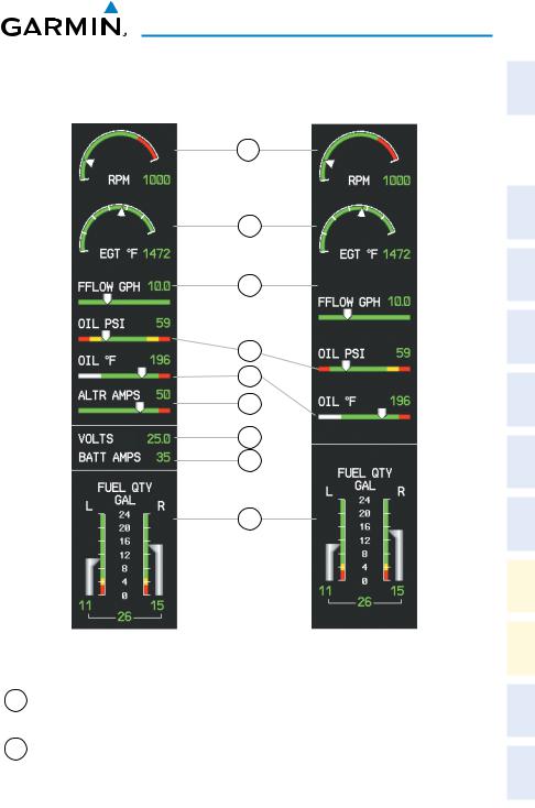
|
Engine Display |
Engine Display when Engine Page is Displayed |
1 |
Tachometer |
Displays propeller speed in revolutions per minute |
|
(RPM) |
(rpm) |
2 |
Exhaust Gas Temperature |
Displays the exhaust gas temperature of the hottest cylinder |
|
(EGT) |
in °F |
Instruments |
Flight |
|
|
EIS |
|
|
|
XPDR/Audio |
Nav/Com/ |
Nav GPS |
|
Planning |
Flight |
Procedures |
|
Avoidance |
Hazard |
Features |
Additional |
Operation |
Abnormal |
Annun/Alerts |
|
Appendix |
|
Index |
|
190-01460-00 Rev. A |
Garmin G1000 Cockpit Reference Guide for the Piper PA-28-181 Archer |
5 |

Flight |
Instruments |
|
|
|
EIS |
|
|
Nav/Com/ |
XPDR/Audio |
|
GPS Nav |
Flight |
Planning |
|
Procedures |
Hazard |
Avoidance |
Additional |
Features |
Abnormal |
Operation |
|
Annun/Alerts |
|
Appendix |
|
Index |
EIS
3 Fuel Flow Indicator |
Displays fuel flow in gallons per hour (gph) |
(FFLOW GPH) |
|
4Oil Pressure Indicator Displays oil pressure in pounds per square inch (psi)
(OIL PSI)
5Oil Temperature Indicator Displays oil temperature in degrees Fahrenheit (°F)
(OIL °F)
6 |
Alternator Current |
Displays each alternator current in amperes |
|
(ALTR AMPS) |
|
7 |
Voltage |
Displays the bus voltage |
|
(VOLTS) |
|
8 |
Battery Current |
Displays the battery current in amperes |
|
(BATT AMPS) |
|
9 |
Fuel Quantity Indicator |
Displays the amount of fuel in gallons (gal) for each |
|
(FUEL QTY GAL) |
side of a standard fuel tank. |
6 |
Garmin G1000 Cockpit Reference Guide for the Piper PA-28-181 Archer |
190-01460-00 Rev. A |
EIS
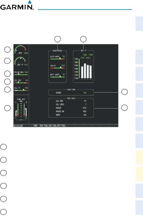
ENGINE PAGE
Press the ENGINE Softkey or turn the large FMS Knob and select the EIS - Engine Page.
10 |
9 |
1 |
|
2 |
|
3 |
|
4 |
|
5 |
8 |
|
|
6 |
7 |
|
|
Engine Page |
1 |
Tachometer |
Displays propeller speed in revolutions per minute |
|
(RPM) |
(rpm) |
2Exhaust Gas Temperature Displays the exhaust gas temperature in °F
(EGT °F)
3 |
Fuel Flow Indicator |
Displays fuel flow in gallons per hour (gph) |
|
(FFLOW GPH) |
|
4Oil Pressure Indicator Displays oil pressure in pounds per square inch (psi)
(OIL PSI)
5Oil Temperature Indicator Displays oil temperature in degrees Fahrenheit (°F)
(OIL °F)
6Fuel Quantity Indicator Displays the amount of fuel in gallons (gal) for each (FUEL QTY GAL) side of a standard fuel tank.
Instruments |
Flight |
|
|
EIS |
|
|
|
XPDR/Audio |
Nav/Com/ |
Nav GPS |
|
Planning |
Flight |
Procedures |
|
Avoidance |
Hazard |
Features |
Additional |
Operation |
Abnormal |
Annun/Alerts |
|
Appendix |
|
Index |
|
190-01460-00 Rev. A |
Garmin G1000 Cockpit Reference Guide for the Piper PA-28-181 Archer |
7 |
Flight |
Instruments |
|
|
|
EIS |
|
|
Nav/Com/ |
XPDR/Audio |
|
GPS Nav |
Flight |
Planning |
|
Procedures |
Hazard |
Avoidance |
Additional |
Features |
Abnormal |
Operation |
|
Annun/Alerts |
|
Appendix |
|
Index |
EIS
7 |
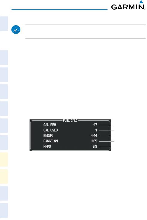
Fuel Calculations Group |
Displays calculated fuel used (GAL USED), endurance |
|
(FUEL CALC) |
(ENDUR), and range (in nautical miles, RANGE NM), |
|
|
and fuel efficiency (in nautical miles per gallon, NMPG) |
|
|
based on the displayed fuel remaining (GAL REM) and |
|
|
the fuel flow totalizer |
8 |
Engine Hours |
Displays the total time in hours the engine has been in |
|
(TACH TIME) |
service |
9 |
Exhaust Gas Temperature |
Displays exhaust gas temperatures for all cylinders in |
|
(EGT °F) |
°F |
10 |
Electrical Group |
Displays alternator (ALTR AMPS) and battery (BATT |
|
(ELECTRICAL) |
AMPS) currents in amperes and bus voltage (VOLTS) |
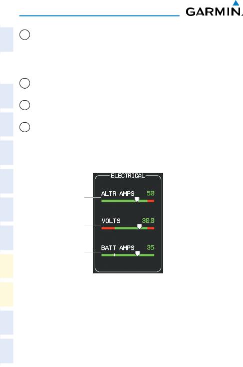
Electrical
Alternator
Current
Bus Voltage
Ammeter
Electrical Group
8 |
Garmin G1000 Cockpit Reference Guide for the Piper PA-28-181 Archer |
190-01460-00 Rev. A |
EIS
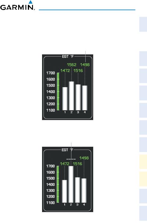
Exhaust Gas Temperature
Exhaust Gas (EGT) temperature readout for each cylinder is shown at the top of the graph. Cylinders with EGTs in the normal range appear in white. The temperature readout is replaced with white dashes if the temperature exceeds the normal range.
Exhaust Gas
Temperatures
Exhaust Gas Temperatures (Normal Range)
Normal Temperature
Range Exceeded
Exhaust Gas Temperatures (Normal Range Exceeded)
Instruments |
Flight |
|
|
EIS |
|
|
|
XPDR/Audio |
Nav/Com/ |
Nav GPS |
|
Planning |
Flight |
Procedures |
|
Avoidance |
Hazard |
Features |
Additional |
Operation |
Abnormal |
Annun/Alerts |
|
Appendix |
|
Index |
|
190-01460-00 Rev. A |
Garmin G1000 Cockpit Reference Guide for the Piper PA-28-181 Archer |
9 |
Flight |
Instruments |
|
|
|
EIS |
|
|
Nav/Com/ |
XPDR/Audio |
|
GPS Nav |
Flight |
Planning |
|
Procedures |
Hazard |
Avoidance |
Additional |
Features |
Abnormal |
Operation |
|
Annun/Alerts |
|
Appendix |
|
Index |
EIS
Fuel Calculations
NOTE: Fuel calculations do not use the aircraft fuel quantity indicators and are calculated from the last time the fuel was reset.
Fuel used (GAL USED), endurance (ENDUR), range (in nautical miles, RANGE NM), and fuel efficiency (in nautical miles per gallon, NMPG) are calculated based on the displayed fuel remaining (GAL REM) and the fuel flow totalizer. The calculated range also takes into account the aircraft’s heading and the wind direction and speed.
Adjusting the fuel totalizer quantity:
On the Engine Page, use the DEC FUEL and INC FUEL softkeys to obtain the desired fuel remaining (GAL REM).
Resetting the fuel totalizer:
On the Engine Page, press the RST FUEL Softkey; this resets displayed fuel remaining (GAL REM) to the maximum fuel capacity for the aircraft and fuel used to zero. Pressing the TABS Softkey resets the fuel remaining quantity to the filler neck tabs quantity.
Set Fuel Remaining
Calculated Fuel Used
Calculated Endurance
Calculated Range
Fuel Efficiency
Fuel Calculations Group
A map feature related to the EIS Fuel Calculations is the Fuel Range Ring, which graphically illustrates the aircraft’s remaining range based on the endurance (ENDUR), heading, groundspeed, and wind direction and speed. The solid green circle represents the range until all the remaining fuel is depleted. The dashed green circle indicates the aircraft range until only reserve fuel remains. Once on reserve fuel, the range is indicated by a solid yellow circle.
The Fuel Range Ring shifts position in relation to the aircraft according to wind effects. For example, more fuel is required for flying into a headwind, and the aircraft’s decreased range in that direction is indicated by the Fuel Range Ring shifting toward the tail of the Aircraft Symbol.
10 |
Garmin G1000 Cockpit Reference Guide for the Piper PA-28-181 Archer |
190-01460-00 Rev. A |

EIS
The amount of reserve fuel (only for purposes of the Fuel Range Ring) is set on the Navigation Map Page Setup Menu in terms of remaining flight time. When enabled the Fuel Range Ring appears on the Navigation Map Page, the Weather Data Link Page, and PFD Inset Map.
Instruments |
Flight |
|
|
EIS |
|
|
|
XPDR/Audio |
Nav/Com/ |
Nav GPS |
|
Planning |
Flight |
Procedures |
|
Avoidance |
Hazard |
Features |
Additional |
Operation |
Abnormal |
Annun/Alerts |
|
Appendix |
|
Index |
|
190-01460-00 Rev. A |
Garmin G1000 Cockpit Reference Guide for the Piper PA-28-181 Archer |
11 |

EIS
Flight |
Instruments |
|
|
|
|
|
EIS |
|
|
|
|
Nav/Com/ |
XPDR/Audio |
|
|
GPS Nav |
|
Flight |
Planning |
|
|
Procedures |
|
|
|
Blank Page |
Hazard |
Avoidance |
|
Additional |
Features |
|
Abnormal |
Operation |
|
|
Annun/Alerts |
|
|
Appendix |
|
|
Index |
|
12 |
Garmin G1000 Cockpit Reference Guide for the Piper PA-28-181 Archer |
190-01460-00 Rev. A |
Loading...