


GPS NAVIGATION SYSTEM
SYSTEME DE NAVIGATION GPS
GPS-NAVIGATIONSSYSTEM
GPS-NAVIGATIESYSTEEM
DNX9280BT
DNX7280BT
DNX5280BT
DNX4280BT
GPS NAVIGATION INSTRUCTION MANUAL
MANUEL D'INSTRUCTIONS DE NAVIGATION DU GPS
HANDBUCH FÜR DAS GPS-NAVIGATIONSSYSTEM
INSTRUCTIEHANDLEIDING GPS-NAVIGATIE
© B64-4844-08

Contents
End-User License Agreements |
4 |
Getting Started |
9 |
|
|
Using the Navigation System |
9 |
|
|
Help When You Need It |
9 |
|
|
|
|
Find It and Go! |
10 |
The Main Pages |
Finding a Restaurant |
10 |
Viewing the Map Page |
Following Your Route |
11 |
Trip Computer |
Adding a Via Point |
11 |
Resetting Trip Information |
Taking a Detour |
11 |
Turn List Page |
Stopping the Route |
11 |
Next Turn Page |
|
|
About Junction View |
|
|
GPS Info Page |
Where To? |
|
12 |
Creating and Editing Routes |
Searching Near Another Location |
12 |
Creating a New Custom Route |
|
Go! Page Options |
|
12 |
Editing Custom Routes |
Finding an Address |
|
12 |
Saving and Modifying the Active Route |
Finding a Place by Spelling the Name |
13 |
Navigating a Saved Route |
|
Using the On-Screen Keyboard |
13 |
Deleting All Saved Routes |
|
Finding Places in a Different Area |
13 |
Stopping Your Route |
|
Narrowing Your Search |
13 |
Adding a Detour to a Route |
|
|
|
|
Using Multiple Route Preview |
Favorites |
|
14 |
Using ecoRoute™ |
Saving Places You Find |
14 |
About ecoRoute |
|
Saving Your Current Location |
14 |
Creating a Vehicle Profile |
|
Setting a Home Location |
14 |
Resetting Your Vehicle Profile |
|
Viewing Saved Places |
15 |
Calibrating Fuel Economy |
|
Editing Saved Places |
|
15 |
Taking the ecoChallenge |
Deleting a Favorite |
|
15 |
About ecoChallenge Scores |
|
|
|
Hiding Your ecoChallenge Score |
|
|
|
Resetting Your Score |
|
|
|
Viewing Your Fuel Economy |
|
DRAFTAbout the Mileage Report |
||
Viewing a Mileage Report
Exporting a Mileage Report
Diagnostics (ecoRoute HD)
Clearing Error Codes (ecoRoute HD)
Gauges (ecoRoute HD)
Changing the Gauges (ecoRoute HD)
Viewing Driving Tips
Setting Routes that Use Less Fuel
16
16
16
16
17
17
17
17
18
18
18
18
18
18
18
19
19
20
20
20
20
20
20
20
21
21
21
21
21
21
22
22
22
22
22
22
2  GPS Navigation Instruction Manual
Using Speech Recognition |
|
Customizing the Settings |
26 |
(DNX9280BT) |
23 |
Customizing the Navigation System |
26 |
Voice Commands |
23 |
Changing the System Settings |
26 |
Search Methods |
23 |
Changing the Map Settings |
26 |
Speaking Text on the Screen |
23 |
Changing the Navigation Settings |
26 |
Speaking Shortcut Commands |
23 |
Adjusting the Display Settings |
26 |
Find Nearest Shortcut Command |
23 |
Route Preferences |
26 |
Speaking the Name of a Popular Place |
24 |
Updating the Time Settings |
27 |
Speaking an Address |
24 |
Setting the Languages |
27 |
|
|
Adding Security |
27 |
Traffic Information |
25 |
Appendix |
28 |
Understanding FM TMC Traffic |
25 |
Updating the Software |
28 |
Traffic in Your Area |
25 |
Updating the Map Data |
28 |
Traffic on Your Route |
25 |
Custom POIs (Points of Interest) |
29 |
Viewing the Traffic Map |
25 |
Finding Custom POIs |
29 |
Viewing Traffic Delays |
25 |
Deleting Custom POIs |
29 |
|
|
Saving Trip Logs |
29 |
|
|
|
|
Icons Used in This Manual
Important precautions are described to prevent injuries and potentially dangerous situations.
Special instructions, supplementary explanations, limitations, and reference pages are described.
Manual Conventions
When you are instructed to “touch” something, use your finger to touch an item on the screen.
The small arrows (>) used in the text indicate that you should touch a series of items. For example, if you see “touch Where To? > Favorites” you should touch Where To?, and then touch
Favorites.
English  3
3

End-User License Agreements
Software License Agreement
BY USING THE DNX9280BT / DNX7280BT / DNX5280BT / DNX4280BT, YOU AGREE TO BE BOUND BY THE TERMS AND CONDITIONS OF THE FOLLOWING SOFTWARE LICENSE AGREEMENT. PLEASE READ THIS AGREEMENT CAREFULLY.
Garmin grants you a limited license to use the software embedded in this device (the “Software”) in binary executable form in the normal operation of the product. Title, ownership rights, and intellectual property rights in and to the Software remain in Garmin.
You acknowledge that the Software is the property of Garmin and is protected under the United States of America copyright laws and international copyright treaties. You further acknowledge
that the structure, organization, and code of the Software are valuable trade secrets of Garmin and that the Software in source code form remains a valuable trade secret of Garmin. You agree not to decompile, disassemble, modify, reverse assemble, reverse engineer, or reduce to human readable form the Software or any part thereof or create any derivative works based on the Software. You agree not to export or re-export the Software to any country in violation of the export control laws of the United States of America.
NAVTEQ® End-user License Agreement
The software embedded in your Garmin product (the “Software”) is owned by Garmin Ltd. or its subsidiaries (“Garmin”). The third-party map data embedded in or accompanying your Garmin product (the “Data”) is owned by NAVTEQ North America LLC and is licensed to Garmin. Both the Software and Data are protected under copyright laws and international copyright treaties. The Software and Data are licensed, not sold. The Software and Data are provided under the following license and are subject to the following terms and conditions which are agreed to by End User (“you” or “your”), on the one hand, and Garmin and its licensors (including their licensors and suppliers) and affiliated companies on the other hand.
IMPORTANT: CAREFULLY READ THIS LICENSE BEFORE USING THIS PRODUCT. INSTALLING, COPYING, OR OTHERWISE USING THIS PRODUCT INDICATES YOUR ACKNOWLEDGMENT THAT YOU HAVE READ THIS LICENSE AND AGREE TO ITS TERMS. IF YOU DO NOT AGREE, RETURN THE COMPLETE PRODUCT WITHIN 10 DAYS OF THE DATE YOU ACQUIRED IT (IF PURCHASED NEW)
FOR A FULL REFUND TO ONE OF THE FOLLOWING:
4  GPS Navigation Instruction Manual
(1) THE DEALER FROM WHICH YOU PURCHASED THIS PRODUCT; (2) Garmin INTERNATIONAL, INC.
CUSTOMER SERVICE, 1200 EAST 151st STREET,
OLATHE, KS 66062, USA; (3) Garmin (EUROPE) LTD., LIBERTY HOUSE, HOUNSDOWN BUSINESS PARK, SOUTHAMPTON, SO40 9LR, UNITED KINGDOM; OR
(4) Garmin CORPORATION CUSTOMER SERVICE, No. 68, JANGSHU 2nd ROAD, SIJHIH, TAIPEI COUNTY, TAIWAN.
License Terms and Conditions
Garmin (“we” or “us”) provides you with storage media containing the computer Software (the “Software”) and the embedded or accompanying digital map Data, including any “online” or electronic documentation and printed materials (together called the “Product” for purposes of this License Agreement), and grants you a limited, non-exclusive license to use the Product in accordance with the terms of this Agreement. You agree to use this Data together with the Garmin product for solely personal, or if applicable, for use in your business’ internal operations, and not for service bureau, time-sharing, resale or other similar purposes. Accordingly, but subject to the restrictions set forth in the following paragraphs, you may copy this Data only as necessary for your use to (i) view it, and (ii) save it, provided that you do not remove any copyright notices that appear and do not modify the Software or Data in any way. You agree not to otherwise reproduce, copy, modify, decompile, disassemble, reverse engineer or create derivative works of any portion of the Product, and may not transfer or distribute it in any form, for any purpose, except to the extent permitted by mandatory laws.
Restrictions. Except where you have been specifically licensed to do so by Garmin, and without limiting the preceding paragraph, you may not use this Data with any products, systems, or applications installed or otherwise connected to or in communication with vehicles, and which are capable of dispatch, fleet management or similar applications where the Data is used by a central control center in dispatching a fleet of vehicles. In addition, you are prohibited from renting or leasing the Data or the Garmin products containing the Data to any other person or third party. Only those
rental car companies that are specifically authorized by Garmin in writing to rent Garmin products containing the Data to their rental customers are permitted to rent out such products.

No Warranty. This Product (including the Data) is provided to you “as is,” and you agree to use it at your own risk. Garmin and its licensors (and their licensors and suppliers) make no guarantees, representations or warranties of any kind,
express or implied, arising by law or otherwise, including but not limited to, content, quality, accuracy, completeness, effectiveness, reliability, merchantability, fitness for a particular purpose, usefulness, use or results to be obtained from the Product, or that the Data or server will be uninterrupted or error-free.
Disclaimer of Warranty. Garmin AND ITS LICENSORS (INCLUDING THEIR LICENSORS AND SUPPLIERS) DISCLAIM ANY WARRANTIES, EXPRESS OR IMPLIED, OF QUALITY, PERFORMANCE, MERCHANTABILITY, FITNESS FOR A PARTICULAR PURPOSE OR NONINFRINGEMENT. NO ORAL OR WRITTEN ADVICE OR INFORMATION PROVIDED BY Garmin OR ITS SUPPLIERS AND LICENSORS SHALL CREATE A WARRANTY, AND YOU ARE NOT ENTITLED TO RELY ON ANY SUCH ADVICE OR INFORMATION. THIS DISCLAIMER OF WARRANTIES IS AN ESSENTIAL CONDITION OF THIS AGREEMENT. Some States, Territories and Countries do not allow certain warranty exclusions, so to that extent the above exclusion may not apply to you.
Disclaimer of Liability. Garmin AND ITS LICENSORS (INCLUDING THEIR LICENSORS AND SUPPLIERS) SHALL NOT BE LIABLE TO YOU: IN RESPECT OF ANY CLAIM, DEMAND OR ACTION, IRRESPECTIVE OF THE NATURE OF THE CAUSE OF THE CLAIM, DEMAND OR ACTION ALLEGING ANY LOSS, INJURY OR DAMAGES, DIRECT OR INDIRECT, WHICH MAY RESULT FROM THE USE OR POSSESSION OF THE INFORMATION; OR FOR ANY LOSS OF PROFIT, REVENUE, CONTRACTS OR SAVINGS, OR ANY OTHER DIRECT, INDIRECT, INCIDENTAL, SPECIAL OR CONSEQUENTIAL DAMAGES ARISING OUT OF YOUR USE OF OR
INABILITY TO USE THIS INFORMATION, ANY DEFECT IN THE DATA OR INFORMATION, OR THE BREACH OF THESE TERMS OR CONDITIONS, WHETHER IN AN ACTION IN CONTRACT OR TORT OR BASED ON A WARRANTY, EVEN IF Garmin OR ITS LICENSORS HAVE BEEN ADVISED OF THE POSSIBILITY OF SUCH DAMAGES. Garmin’S AND ITS LICENSORS’ TOTAL AGGREGATE LIABILITY WITH RESPECT
TO ITS OBLIGATIONS UNDER THIS AGREEMENT OR OTHERWISE WITH RESPECT TO THE Garmin
PRODUCT OR THE DATA SHALL NOT EXCEED $1.00. Some States, Territories and Countries do not allow certain liability exclusions or damages limitations, so to that extent the above may not apply to you.
Disclaimer of Endorsement. Reference to any products, services, processes, hypertext links
to third parties or other Data by trade name, trademark, manufacturer, supplier or otherwise does not necessarily constitute or imply its endorsement, sponsorship or recommendation by Garmin or its licensors. Product and service information are the sole responsibility of each individual vendor. The NAVTEQ name and logo, the NAVTEQ and NAVTEQ ON BOARD trademarks and logos, and other trademarks and trade names owned by NAVTEQ North America LLC may not be used in any commercial manner without the prior written consent of NAVTEQ.
Export Control. You agree not to export from anywhere any part of the Data provided to you or any direct product thereof except in compliance with, and with all licenses and approvals required under, applicable export laws, rules and regulations.
Indemnity. You agree to indemnify, defend and hold Garmin and its licensors (including their respective licensors, suppliers, assignees, subsidiaries, affiliated companies, and the respective officers, directors, employees, shareholders, agents and representatives of each of them) free and harmless from and against any liability, loss, injury (including injuries resulting in
death), demand, action, cost, expense, or claim of any kind or character, including but not limited to attorney’s fees, arising out of or in connection with any use or possession by you of the Product (including the Data).
Entire Agreement. These terms and conditions constitute the entire agreement between Garmin (and its licensors, including their licensors and suppliers) and you pertaining to the subject matter hereof, and supersedes in their entirety any and
all written or oral agreements previously existing between us with respect to such subject matter.
Governing Law.
(a) For European Union NAVTEQ Data
The above terms and conditions shall be governed by the laws of the Netherlands, without giving effect to (i) its conflict of laws provisions, or (ii)
the United Nations Convention for Contracts for the International Sale of Goods, which is explicitly excluded. You agree to submit to the jurisdiction of the Netherlands for any and all disputes, claims and actions arising from or in connection with the Data provided to you hereunder.
(b) For North American NAVTEQ Data and other non-European Union NAVTEQ Data
The above terms and conditions shall be governed by the laws of Illinois, without giving effect to (i) its conflict of laws provisions, or (ii) the United Nations Convention for Contracts for the International Sale of Goods, which is explicitly excluded. You agree
English  5
5

End-User License Agreements
to submit to the jurisdiction of Illinois for any and all disputes, claims and actions arising from or in connection with the Data provided to you hereunder.
Government End Users. If End User is an agency, department, or other entity of the United States Government, or funded in whole or in part by the U.S. Government, then use, duplication, reproduction, release, modification, disclosure or transfer of the Product and accompanying documentation is subject to restrictions as set
forth in DFARS 252.227-7014(a)(1) (JUN 1995) (DOD commercial computer software definition), DFARS 27.7202-1 (DOD policy on commercial computer software), FAR 52.227-19 (JUN 1987) (commercial computer software clause for civilian agencies), DFARS 252.227-7015 (NOV 1995) (DOD technical data – commercial items clause); FAR 52.227-14 Alternates I, II, and III (JUN 1987) (civilian agency technical data and noncommercial computer software clause); and/or FAR 12.211 and FAR 12.212 (commercial item acquisitions), as applicable.
In case of conflict between any of the FAR and DFARS provisions listed herein and this License, the construction that provides greater limitations on the Government’s rights shall control. The contractor/manufacturer is Garmin International, Inc., 1200 East 151st Street, Olathe, KS 66062, USA and NAVTEQ North America LLC, 222 Merchandise Mart Plaza, Suite 900, Chicago, Illinois 60654.
DMTI Spatial, Inc. End User License
Agreement
The software embedded in your Garmin product is owned by Garmin Ltd. or its subsidiaries (“Garmin”). The third-party postal code data (the “Licensed Product”) embedded in or accompanying your Garmin product is owned by DMTI Spatial, Inc. and is licensed to Garmin. Both the software and Licensed Product are protected under copyright laws and international copyright treaties.
THIS is a legal Agreement between you, the end user, and DMTI Spatial, Inc. BY LOADING THE PRODUCT(S) WITH THIS AGREEMENT YOU ARE AGREEING TO BE BOUND BY THE TERMS OF THIS AGREEMENT. IF YOU DO NOT AGREE TO THE
TERMS OF THIS AGREEMENT, PROMPTLY (within 7 days of purchase) RETURN THE PRODUCTS AND ANY ACCOMPANYING ITEMS (including written materials) TO Garmin INTERNATIONAL, INC. CUSTOMER SERVICE, 1200 EAST 151ST STREET, OLATHE, KANSAS 66062, FOR A REFUND.
DMTI Spatial hereby grants to you a non-exclusive, non-transferable license to use the data contained on the media in this package (the “Licensed Product”) solely for personal non-commercial
use or internal use in your business, on a single computer, Pocket PC, or Palm device in conjunction with Garmin software, and with compatible Garmin products that you personally own. Your use of
the data is subject to the following terms and conditions:
You acknowledge that the Licensed Product(s) belong to DMTI Spatial and its third party supplier, and that the Licensed Product(s) are copyrighted. Unauthorized copying of the Licensed Product(s), is expressly forbidden and you may be held legally responsible for copyright infringement which is caused or encouraged by your failure to abide by the terms of this agreement. You may make one archival copy of the Licensed Product(s), solely for your own use, subject to the following restrictions:
(1) The archival copy must be treated in the same way as the original copy; (2) No copy may be used while any other copy is in use. If you make an archival copy of the Licensed Product(s), you must include on it the copyright notice that is on the original media.
You may not reproduce, sell, rent, lease, loan, distribute or sublicense the Licensed Product(s) or otherwise transfer the Licensed Product(s) to any third party, use the Licensed Product for commercial purposes except for internal use in your business, decompile, disassemble, reverseengineer the Licensed Product(s), or use the
6  GPS Navigation Instruction Manual

Licensed Product to create any derived product for any of these prohibited purposes. You may not place the Licensed Product(s) on the Internet without a prior written agreement with DMTI Spatial.
In no event shall DMTI Spatial or its third party supplier(s) be liable to you or your organization for any indirect damages including any lost profits, lost savings, interruption of business, loss of business opportunities or other incidental or consequential damages, arising out of your possession, use of,
or inability to use the Licensed Product(s), even if DMTI Spatial, its third party supplier(s), or any authorized dealer, has been advised of the
possibility of the damages, or for any claim by any other party. In no event shall DMTI Spatial have any liability for damage in excess of the license fee paid for the Licensed Product(s).
You shall indemnify and hold DMTI Spatial, its third party supplier(s) and their officers, employees and agents, harmless from and against any claim, demand or action, irrespective of the nature of the claim, demand or action, alleging loss, costs, damages, expenses, or injury (including injury from death) resulting from your authorized or unauthorized, use, possession, modification, or alteration of the Licensed Product(s).
THE LICENSED PRODUCT(S) AND THE ASSOCIATED WRITTEN MATERIALS IN CONNECTION THEREWITH ARE PROVIDED “AS IS” WITHOUT WARRANTY OF ANY KIND, EITHER EXPRESSED OR IMPLIED, ARISING BY LAW OR OTHERWISE, INCLUDING BUT NOT LIMITED TO WARRANTIES OF EFFECTIVENESS, COMPLETENESS, ACCURACY, MERCHANTABILITY OR FITNESS FOR A PARTICULAR PURPOSE. THE ENTIRE RISK AS TO THE QUALITY AND PERFORMANCE
OF THE LICENSED PRODUCT(S) IS WITH YOU, THE END USER. NO ORAL OR WRITTEN ADVICE GIVEN BY DMTI SPATIAL OR ITS DEALERS, DISTRIBUTORS, AGENTS OR EMPLOYEES CREATES A WARRANTY OR IN NAY WAY INCREASES DMTI SPATIAL’S LIABILITY AND YOU MAY NOT RELY ON ANY SUCH INFORMATION OR ADVICE.
No statement or recommendation made or assistance given by DMTI Spatial or by its representatives or employees shall constitute a waiver by DMTI Spatial or any of the provisions herein. Nor does or will DMTI Spatial warrant any services it may provide in connection with the use of the Licensed product(s), to include any assistance, training, or other consultation with you.
This license is effective until terminated. This license will terminate automatically without notice from DMTI Spatial if you fail to comply with any provision of this License Agreement. Upon termination, you
shall destroy or return the Licensed Product(s) including any written materials and all copies of the Licensed Product(s) and any written materials in connection therewith have been destroyed or returned to DMTI Spatial.
This Agreement shall be governed by the laws of the Province of Ontario.
©2007 DMTI Spatial Inc. (except for data licensed from third parties).
DMTI Spatial is an authorized user and distributor of selected Statistics Canada Computer files under Licensing Agreement 6230.
© Copyright, HER MAJESTY THE QUEEN IN RIGHT OF CANADA, as represented by the Minister of Industry, Statistics Canada 1996.
Digital Topographic Data produced under license from Her Majesty the Queen in Right of Canada, with permission of Natural Resources Canada.
English  7
7

End-User License Agreements
Traffic Service End-user Subscriber |
use of or inability to use the Garmin product or the |
Agreement |
traffic data, even if Garmin has been advised of the |
possibility of such damages. |
The Traffic Service Provider holds the rights to the traffic incident data and RDS/TMC network
through which it is delivered. You may not modify, copy, scan, or use any other method to reproduce, duplicate, republish, transmit, or distribute in any way any portion of traffic incident data. You agree to indemnify, defend, and hold harmless the Traffic Service Provider (and its affiliates) and Garmin Ltd. (and its subsidiaries) against any and all claims, damages, costs, or other expenses that arise directly or indirectly out of (a) your unauthorized use of the traffic incident data or the RDS/TMC network, (b) your violation of this End User Subscriber Agreement and/or (c) any unauthorized or unlawful activities by you in connection herewith.
The Traffic Service Data is informational only. You assume all risk of use. The Traffic Service Provider, Garmin Ltd. (and its subsidiaries), and their suppliers make no representations about content, traffic and road conditions, route usability, or speed.
Garmin and its Traffic Service Provider(s) make no warranty of fitness or compatibility of the traffic data with the Garmin product and no warranty that the traffic data will operate properly as integrated and interfaced with the Garmin product. In addition, Garmin and its Traffic Service Provider(s) make no warranty with regard to the reliability, accuracy, exhaustiveness and completeness of
the traffic data, which may contain inaccuracies and/or errors from time to time. To the maximum extent permitted by applicable law, any and all warranties of any kind whatsoever with regard to the traffic data are hereby expressly waived and excluded, including, but not limited to, those of merchantability, fitness for a particular purpose, accuracy or completeness of the traffic data, and/or a lack of viruses.
Garmin and its Traffic Service Provider(s) disclaim all liability for any loss, injury, or damage resulting from use of or inability to use the Garmin product and traffic data as a result of weather difficulties, the destruction of transmitters and/or other broadcasting infrastructures, a natural disaster, and/ or a lack of reliability, completeness or accuracy
of the traffic data. In no event shall Garmin or its Traffic Service Provider(s) be liable to you or any other party for any compensatory, indirect, incidental, special, or consequential damages (including, without limitation, indirect, direct, special, punitive, or exemplary damages for loss of business, loss of profits, business interruption, or loss of business information) arising out of the
If you purchase or your Garmin product is preloaded with “lifetime” or “one-time” traffic, you will receive traffic data for one (1) compatible Garmin product until your product’s useful life expires
or Garmin no longer receives traffic data from its Traffic Service Provider. Your traffic subscription may not be transferred to another person or another Garmin product. Garmin may terminate this Agreement for any reason, including, but not limited to, if Garmin finds that you have violated any of the terms of this Agreement or the contract between Garmin and its Traffic Service Provider terminates.
8  GPS Navigation Instruction Manual
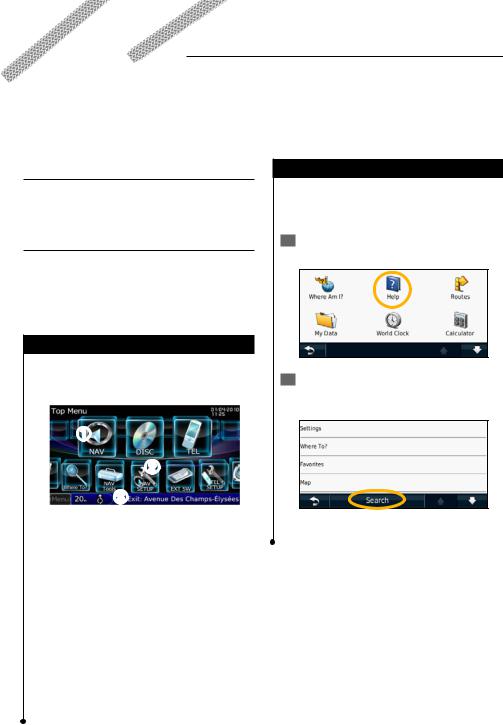
Getting Started
The first time you use your Kenwood Navigation System, you need to set up your system. The Help menu provides additional information.
 WARNING
See "Safety Precautions and Important Information" in the Quick Start Guide for product warnings and other important information.
⁄
•The screen shots shown in this manual may not exactly match the screens on your navigation system. The images used in this manual are intended for reference only.
Using the Navigation System
For complete audio system information, see the other Kenwood system manuals.
DNX9280BT
Touch to access the navigation system.Touch to set up the navigation system.
When navigating, this displays Kenwood audio. When using audio, this displays navigation information.
⁄
Help When You Need It
Touch Tools > Help to get more information about using your navigation system. Touch a category to view information about a topic.
1 Touch Tools > Help.
2To search the Help topics for a keyword, touch Search.
•The hands-free phone feature is only available if your mobile phone has Bluetooth® wireless technology and has been paired to the navigation system. See the other Kenwood manuals and your phone manual for setup and pairing instructions.
English  9
9

Find It and Go!
The Where To? page provides several different categories for you to use when searching for addresses, cities, and other locations. The detailed map loaded in your navigation system contains millions of points of interest, such as restaurants, hotels, and auto services.
Finding a Restaurant |
|
|
Select a place. |
|
5 |
||
|
|
|
|
1 Touch Where To?.
6 Select Press for More to see the Review page.
2 Select a category.
7 Touch Go!.
3 Select a subcategory.
4 Select a type.
10  GPS Navigation Instruction Manual
 Loading...