


GPS NAVIGATION SYSTEM
DNX6140
DNX6000EX
DNX5140
GPS NAVIGATION INSTRUCTION MANUAL
© B64-4275-00
Contents
Safety Precautions and Important |
4 |
Information |
Find It and Go! |
10 |
Finding a Restaurant |
10 |
Following Your Route |
11 |
Where To? |
12 |
Finding an Address |
12 |
Finding a Place Using the Map |
12 |
Understanding the Information Page |
13 |
Finding Recently Found Places |
13 |
Finding Places in a Different Area |
13 |
Narrowing Your Search |
13 |
My Locations |
14 |
Saving Places You Find |
14 |
Saving Your Current Location |
14 |
Setting a Home Location |
14 |
Finding Saved Places |
15 |
Editing Saved Places |
15 |
Deleting a Saved Place |
15 |
Getting Started |
9 |
First Time Setup |
9 |
The Map and Other Tools |
16 |
Viewing the Map Page |
16 |
Trip Computer |
16 |
Turn List |
17 |
GPS Info Page |
17 |
Creating and Editing Routes |
18 |
Creating a New Saved Route |
18 |
Editing a Saved Route |
18 |
Adding an Intermediate Destination |
18 |
Point to Your Route |
|
Saving the Active Route |
18 |
Navigating a Saved Route |
18 |
Recalculating the Route |
18 |
Deleting All Saved Routes |
19 |
Stopping Your Route |
19 |
Adding a Detour to a Route |
19 |
Adding Avoidances |
19 |
2  DNX6140/DNX6000EX/DNX5140 GPS Navigation Instruction Manual
Using the Logs |
20 |
Changing the Settings |
24 |
Adjusting the Track Log |
20 |
Changing the General Settings |
24 |
Using the Mileage Logs |
20 |
Changing the Map Settings |
25 |
|
|
Changing the Navigation Settings |
26 |
Traffic Information |
21 |
Adjusting the Traffic Settings |
26 |
Viewing Information (About) |
26 |
||
Connecting the Traffic Module |
21 |
Restoring the Settings |
26 |
Viewing Traffic Events |
21 |
|
|
Avoiding Traffic |
21 |
|
|
Traffic Symbols |
22 |
|
|
Changing the Traffic Settings |
22 |
|
|
Adding a Traffic Receiver Subscription |
22 |
|
|
Icons used in this manual
Important precautions are described to prevent injuries etc.
Special instructions, supplementary explanations, limitations, and reference pages are described.
English  3
3

Safety Precautions and Important Information
Read this information carefully before starting to operate the Kenwood Car Navigation System and follow the instructions in this manual. Neither Kenwood nor Garmin shall be liable for problems or accidents resulting from failure to observe the instructions in this manual.
2WARNINGS
To prevent injury or fire, take the following precautions:
•To prevent a short circuit, never put or leave any metallic objects (such as coins or metal tools) inside the unit.
•Do not watch or fix your eyes on the unit’s display when you are driving for any extended period.
•Mounting and wiring this product requires skills and experience. For safety’s sake, leave the mounting and wiring work to professionals.
Failure to avoid the following potentially hazardous situations could result in an accident or collision resulting in death or serious injury.
When navigating, carefully compare information displayed on the navigation system to all available navigation sources, including information from street signs, visual sightings, and maps. For safety, always resolve any discrepancies or questions before continuing navigation.
Always operate the vehicle in a safe manner. Do not become distracted by the navigation system
while driving, and always be fully aware of all driving conditions. Minimize the amount of time spent viewing the screen of the navigation system while driving, and use voice prompts when possible.
Do not enter destinations, change settings, or access any functions requiring prolonged use of the navigation system controls while driving. Stop your vehicle in a safe and legal manner before attempting such operations.
Keep the system volume at a low enough level to be able to hear outside noises while driving. If you can no longer hear outside noises, you may be unable to react adequately to the traffic situation. This may cause accidents.
The navigation system will not display the correct current position of the vehicle the first time it is used after purchase, or if the vehicle battery is disconnected. GPS satellite signals will soon be received, however, and the correct position will be displayed.
Be careful of the ambient temperature. Using the navigation system at extreme temperatures can lead to malfunction or damage. Also note that the unit can be damaged by strong vibration, by metal objects, or by water getting inside the unit.
2CAUTIONS
Failure to avoid the following potentially hazardous situations may result in injury or property damage.
The navigation system is designed to provide you with route suggestions. It does not reflect road closures or road conditions, traffic congestion, weather conditions, or other factors that may affect safety or timing while driving.
Use the navigation system only as a navigational aid. Do not attempt to use the navigation system for any purpose requiring precise measurement of direction, distance, location, or topography.
The Global Positioning System (GPS) is operated by the United States government, which is solely responsible for its accuracy and maintenance. The government system is subject to changes that could affect the accuracy and performance of all GPS equipment, including the navigation system. Although the navigation system is a precision navigation device, any navigation device can be misused or misinterpreted and, therefore, become unsafe.
IMPORTANT INFORMATION
Vehicle Battery Preservation
This navigation system can be used when the ignition key is turned to ON or ACC. To preserve the battery, however, it should be used with the engine running whenever possible. Using the navigation system for a long time with the engine switched off can cause the battery to run down.
Map Data Information
One of the goals of Garmin is to provide customers with the most complete and accurate cartography that is available to us at a reasonable cost. We use a combination of governmental and private data sources, which we identify in product literature and copyright messages displayed to the consumer. Virtually all data sources contain inaccurate or incomplete data to some extent. In some countries,
complete and accurate map information is either not available or is prohibitively expensive.
4  DNX6140/DNX6000EX/DNX5140 GPS Navigation Instruction Manual

Software License Agreement
BY USING THE DNX6140/DNX6000EX/DNX5140, YOU AGREE TO BE BOUND BY THE TERMS AND CONDITIONS OF THE FOLLOWING SOFTWARE
LICENSE AGREEMENT. PLEASE READ THIS AGREEMENT CAREFULLY.
Garmin grants you a limited license to use the software embedded in this device (the “Software”) in binary executable form in the normal operation of the product. Title, ownership rights, andintellectual property rights in and to the Software remain in Garmin.
You acknowledge that the Software is the property of Garmin and is protected under the United States of America copyright laws and international copyright treaties. You further acknowledge that the structure, organization, and code of the Software are valuable trade secrets of Garmin and that the Software in source code form remains a valuable trade secret of Garmin. You agree not to decompile, disassemble, modify, reverse assemble, reverse engineer, or reduce to human readable form the Software or any part thereof or create any derivative works based on the Software. You agree not to export or re-export the Software to any country in violation of the export control laws of the United States of America.
NAVTEQ® End-user License Agreement
The software embedded in your Garmin product (the “Software”) is owned by Garmin Ltd. or its subsidiaries (“Garmin”). The third-party map data embedded in or accompanying your Garmin product (the “Data”) is
owned by NAVTEQ North America LLC and is licensed to Garmin. Both the Software and Data are protected under copyright laws and international copyright treaties. The Software and Data are licensed, not
sold. The Software and Data are provided under the following license and are subject to the following terms and conditions which are agreed to by End User (“you” or “your”), on the one hand, and Garmin and its licensors (including their licensors and suppliers) and affiliated companies on the other hand.
IMPORTANT: CAREFULLY READ THIS LICENSE BEFORE USING THIS PRODUCT. INSTALLING, COPYING, OR OTHERWISE USING THIS PRODUCT INDICATES YOUR ACKNOWLEDGMENT THAT YOU HAVE READ THIS LICENSE AND AGREE TO ITS TERMS. IF YOU DO NOT AGREE, RETURN THE COMPLETE PRODUCT WITHIN 10 DAYS OF THE DATE YOU ACQUIRED IT
(IF PURCHASED NEW) FOR A FULL REFUND TO ONE OF THE FOLLOWING: (1) THE DEALER FROM
WHICH YOU PURCHASED THIS PRODUCT; (2) Garmin INTERNATIONAL, INC. CUSTOMER SERVICE, 1200 EAST
151st STREET, OLATHE, KS 66062, USA; (3) Garmin (EUROPE) LTD., LIBERTY HOUSE, HOUNSDOWN BUSINESS PARK, SOUTHAMPTON, SO40 9RB, UNITED KINGDOM; OR (4) Garmin CORPORATION CUSTOMER SERVICE, No. 68, JANGSHU 2nd ROAD, SHIJR, TAIPEI COUNTY, TAIWAN.
License Terms And Conditions
Garmin (“we” or “us”) provides you with storage media containing the computer Software (the “Software”) and the embedded or accompanying digital map Data, including any “online” or electronic documentation and printed materials (together called the “Product” for purposes of this License Agreement), and grants you a limited, non-exclusive license to use the Product in accordance with the terms of this Agreement. You agree to use this Data together with the Garmin product for solely personal, or if applicable, for use in your business’ internal operations, and not for service bureau, time-sharing, resale or other similar purposes. Accordingly, but subject to the restrictions set forth in the following paragraphs, you may copy this Data only as necessary for your use to (i) view it, and (ii) save it, provided that you do not remove any copyright notices that appear and do not modify the Software or Data in any way. You agree not to otherwise reproduce, copy, modify, decompile, disassemble, reverse engineer or create derivative works of any portion of the Product, and may not transfer or distribute it in any form,
for any purpose, except to the extent permitted by mandatory laws.
Restrictions. Except where you have been specifically licensed to do so by Garmin, and without limiting the preceding paragraph, you may not use this Data with any products, systems, or
applications installed or otherwise connected to or in communication with vehicles, and which are capable of dispatch, fleet management or similar applications where the Data is used by a central control center in dispatching a fleet of vehicles. In addition, you are prohibited from renting or leasing the Data or the Garmin products containing the Data to any other person or third party. Only those rental car companies that are specifically authorized by Garmin in writing to rent Garmin products containing the Data to their rental customers are permitted to rent out such products.
No Warranty. This Product (including the Data) is provided to you “as is,” and you agree to use it at your own risk. Garmin and its licensors (and their licensors and suppliers) make no guarantees,
representations or warranties of any kind, express or implied, arising by law or otherwise, including but not limited to, content, quality, accuracy, completeness,
English  5
5

Safety Precautions and Important Information
effectiveness, reliability, merchantability, fitness for a particular purpose, usefulness, use or results to be
obtained from the Product, or that the Data or server will be uninterrupted or error-free.
Disclaimer of Warranty. Garmin AND ITS LICENSORS (INCLUDING THEIR LICENSORS AND SUPPLIERS) DISCLAIM ANY WARRANTIES, EXPRESS OR IMPLIED, OF QUALITY, PERFORMANCE, MERCHANTABILITY, FITNESS FOR A PARTICULAR PURPOSE OR NONINFRINGEMENT. NO ORAL OR WRITTEN ADVICE OR INFORMATION PROVIDED BY Garmin OR ITS SUPPLIERS AND LICENSORS SHALL CREATE A WARRANTY, AND YOU ARE NOT ENTITLED TO RELY ON ANY SUCH ADVICE OR INFORMATION. THIS DISCLAIMER OF WARRANTIES IS AN ESSENTIAL CONDITION OF THIS AGREEMENT. Some States, Territories and Countries do not allow certain warranty exclusions, so to that extent the above exclusion may not apply to you.
Disclaimer of Liability. Garmin AND ITS LICENSORS (INCLUDING THEIR LICENSORS AND SUPPLIERS) SHALL NOT BE LIABLE TO YOU: IN RESPECT OF ANY CLAIM, DEMAND OR ACTION, IRRESPECTIVE OF THE NATURE OF THE CAUSE OF THE CLAIM, DEMAND OR ACTION ALLEGING ANY LOSS, INJURY OR DAMAGES, DIRECT OR INDIRECT, WHICH MAY RESULT FROM THE USE OR POSSESSION OF THE INFORMATION; OR FOR ANY LOSS OF PROFIT, REVENUE, CONTRACTS OR SAVINGS, OR ANY OTHER DIRECT, INDIRECT,
INCIDENTAL, SPECIAL OR CONSEQUENTIAL DAMAGES ARISING OUT OF YOUR USE OF OR INABILITY TO USE THIS INFORMATION, ANY DEFECT IN THE DATA OR INFORMATION, OR THE BREACH OF THESE TERMS
OR CONDITIONS, WHETHER IN AN ACTION IN CONTRACT OR TORT OR BASED ON A WARRANTY, EVEN IF Garmin OR ITS LICENSORS HAVE BEEN ADVISED OF THE POSSIBILITY OF SUCH DAMAGES. Garmin’S AND ITS LICENSORS’TOTAL AGGREGATE LIABILITY WITH RESPECT TO ITS OBLIGATIONS UNDER THIS AGREEMENT OR OTHERWISE WITH RESPECT
TO THE Garmin PRODUCT OR THE DATA SHALL NOT EXCEED $1.00. Some States, Territories and Countries do not allow certain liability exclusions or damages limitations, so to that extent the above may not apply to you.
Disclaimer of Endorsement. Reference to any products, services, processes, hypertext links to third parties or other Data by trade name, trademark, manufacturer, supplier or otherwise does not necessarily constitute or imply its endorsement, sponsorship or recommendation by Garmin or
its licensors. Product and service information are the sole responsibility of each individual vendor. The NAVTEQ® name and logo, the NAVTEQ and NAVTEQ ON BOARD® trademarks and logos, and other trademarks and trade names owned by NAVTEQ North America LLC may not be used in
any commercial manner without the prior written consent of NAVTEQ.
Export Control. You agree not to export from anywhere any part of the Data provided to you or any direct product thereof except in compliance with, and with all licenses and approvals required under, applicable export laws, rules and regulations. Indemnity. You agree to indemnify, defend and hold Garmin and its licensors (including their respective licensors, suppliers, assignees, subsidiaries, affiliated companies, and the respective officers, directors, employees, shareholders, agents and representatives of each of them) free and harmless from and against any liability, loss, injury (including injuries resulting
in death), demand, action, cost, expense, or claim of any kind or character, including but not limited to attorney’s fees, arising out of or in connection with any use or possession by you of the Product (including the Data).
Entire Agreement. These terms and conditions constitute the entire agreement between Garmin (and its licensors, including their licensors and suppliers) and you pertaining to the subject matter hereof, and supersedes in their entirety any and
all written or oral agreements previously existing between us with respect to such subject matter.
Governing Law.
(a) For European Union NAVTEQ Data
The above terms and conditions shall be governed by the laws of the Netherlands, without giving effect to (i) its conflict of laws provisions, or (ii) the United Nations Convention for Contracts for the International Sale of Goods, which is explicitly excluded. You agree to submit to the jurisdiction of the Netherlands for any and all disputes, claims and actions arising from or in connection with the Data provided to you hereunder.
(b) For North American NAVTEQ Data and other nonEuropean Union NAVTEQ Data
The above terms and conditions shall be governed by the laws of Illinois, without giving effect to (i) its conflict of laws provisions, or (ii) the United Nations Convention for Contracts for the International Sale of Goods, which is explicitly excluded. You agree to submit to the jurisdiction of Illinois for any and all disputes, claims and actions arising from or in
connection with the Data provided to you hereunder. Government End Users. If End User is an agency, department, or other entity of the United States Government, or funded in whole or in part by the U.S. Government, then use, duplication, reproduction, release, modification, disclosure or transfer of the Product and accompanying documentation is subject to restrictions as set forth in DFARS 252.227-
7014(a)(1) (JUN 1995) (DOD commercial computer
6  DNX6140/DNX6000EX/DNX5140 GPS Navigation Instruction Manual

software definition), DFARS 27.7202-1 (DOD policy on commercial computer software), FAR 52.227-19 (JUN 1987) (commercial computer software clause for civilian agencies), DFARS 252.227-7015 (NOV 1995) (DOD technical data – commercial items clause);
FAR 52.227-14 Alternates I, II, and III (JUN 1987) (civilian agency technical data and noncommercial computer software clause); and/or FAR 12.211 and FAR 12.212 (commercial item acquisitions), as
applicable. In case of conflict between any of the FAR and DFARS provisions listed herein and this License, the construction that provides greater limitations on the Government’s rights shall control. The contractor/ manufacturer is Garmin International, Inc., 1200 East 151st Street, Olathe, KS 66062, USA and NAVTEQ® North America LLC, 222 Merchandise Mart Plaza, Suite 900, Chicago, Illinois 60654.
DMTI Spatial, Inc. End User License
Agreement
The software embedded in your Garmin product is owned by Garmin Ltd. or its subsidiaries (“Garmin”). The third-party postal code data (the “Licensed Product”) embedded in or accompanying your Garmin product is owned by DMTI Spatial, Inc. and is licensed to Garmin. Both the software and Licensed Product are protected under copyright laws and international copyright treaties.
THIS is a legal Agreement between you, the end user, and DMTI Spatial, Inc. BY LOADING THE PRODUCT(S) WITH THIS AGREEMENT YOU ARE AGREEING TO
BE BOUND BY THE TERMS OF THIS AGREEMENT. IF YOU DO NOT AGREE TO THE TERMS OF THIS
AGREEMENT, PROMPTLY (within 7 days of purchase) RETURN THE PRODUCTS AND ANY ACCOMPANYING ITEMS (including written materials) TO Garmin INTERNATIONAL, INC. CUSTOMER SERVICE, 1200 EAST 151ST STREET, OLATHE, KANSAS 66062, FOR A REFUND.
DMTI Spatial hereby grants to you a non-exclusive, non-transferable license to use the data contained on the media in this package (the “Licensed Product”) solely for personal non-commercial use or internal use in your business, on a single computer, Pocket PC, or Palm device in conjunction with Garmin software, and with compatible Garmin products that you personally own. Your use of the data is subject to the following terms and conditions:
You acknowledge that the Licensed Product(s) belong to DMTI Spatial and its third party supplier, and that the Licensed Product(s) are copyrighted. Unauthorized copying of the Licensed Product(s), is expressly forbidden and you may be held legally responsible for copyright infringement which is
caused or encouraged by your failure to abide by the terms of this agreement. You may make one archival copy of the Licensed Product(s), solely for your own use, subject to the following restrictions: (1) The archival copy must be treated in the same way as the original copy; (2) No copy may be used while any other copy is in use. If you make an archival copy of the Licensed Product(s), you must include on it the copyright notice that is on the original media.
You may not reproduce, sell, rent, lease, loan, distribute or sublicense the Licensed Product(s) or otherwise transfer the Licensed Product(s) to any third party, use the Licensed Product for commercial purposes except for internal use in your business, decompile, disassemble, reverse-engineer the Licensed Product(s), or use the Licensed Product
to create any derived product for any of these prohibited purposes. You may not place the Licensed Product(s) on the Internet without a prior written agreement with DMTI Spatial.
In no event shall DMTI Spatial or its third party supplier(s) be liable to you or your organization for any indirect damages including any lost profits, lost savings, interruption of business, loss of business opportunities or other incidental or consequential damages, arising out of your possession, use of, or inability to use the Licensed Product(s), even if DMTI Spatial, its third party supplier(s), or any authorized dealer, has been advised of the possibility of the damages, or for any claim by any other party. In no event shall DMTI Spatial have any liability for damage in excess of the license fee paid for the Licensed Product(s).
You shall indemnify and hold DMTI Spatial, its third party supplier(s) and their officers, employees and agents, harmless from and against any claim, demand or action, irrespective of the nature of the claim, demand or action, alleging loss, costs, damages, expenses, or injury (including injury from death) resulting from your authorized or unauthorized, use, possession, modification, or alteration of the Licensed Product(s).
THE LICENSED PRODUCT(S) AND THE ASSOCIATED WRITTEN MATERIALS IN CONNECTION THEREWITH ARE PROVIDED “AS IS” WITHOUT WARRANTY OF ANY KIND, EITHER EXPRESSED OR IMPLIED, ARISING BY LAW OR OTHERWISE, INCLUDING BUT NOT LIMITED TO WARRANTIES OF EFFECTIVENESS, COMPLETENESS, ACCURACY, MERCHANTABILITY OR FITNESS FOR A PARTICULAR PURPOSE. THE ENTIRE RISK AS TO THE QUALITY AND PERFORMANCE OF THE LICENSED PRODUCT(S) IS WITH YOU, THE END USER. NO ORAL OR WRITTEN ADVICE GIVEN BY DMTI SPATIAL OR ITS DEALERS, DISTRIBUTORS, AGENTS OR EMPLOYEES CREATES A WARRANTY OR IN NAY WAY INCREASES DMTI SPATIAL’S LIABILITY AND YOU MAY NOT RELY ON
English  7
7

Safety Precautions and Important Information
ANY SUCH INFORMATION OR ADVICE.
No statement or recommendation made or assistance given by DMTI Spatial or by its representatives
or employees shall constitute a waiver by DMTI Spatial or any of the provisions herein. Nor does or will DMTI Spatial warrant any services it may
provide in connection with the use of the Licensed product(s), to include any assistance, training, or other consultation with you.
This license is effective until terminated. This license will terminate automatically without notice from DMTI Spatial if you fail to comply with any provision of this License Agreement. Upon termination, you shall destroy or return the Licensed Product(s) including any written materials and all copies of the Licensed Product(s) and any written materials in connection therewith have been destroyed or returned to DMTI Spatial.
This Agreement shall be governed by the laws of the Province of Ontario.
©2007 DMTI Spatial Inc. (except for data licensed from third parties).
DMTI Spatial is an authorized user and distributor of selected Statistics Canada Computer files under Licensing Agreement 6230.
© Copyright, HER MAJESTY THE QUEEN IN RIGHT OF CANADA, as represented by the Minister of Industry, Statistics Canada 1996.
Digital Topographic Data produced under license from Her Majesty the Queen in Right of Canada, with permission of Natural Resources Canada.
8  DNX6140/DNX6000EX/DNX5140 GPS Navigation Instruction Manual
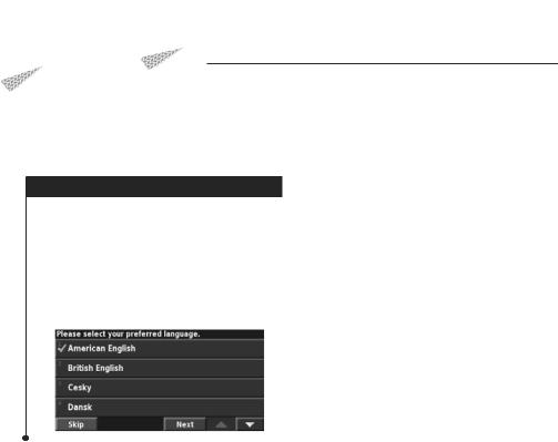
Getting Started
The first time you use your Kenwood Navigation System, you need to set up your system.
First Time Setup
These are the steps that you need to complete to set up the system. These steps normally have to be performed only once.
•Select a language.
•Select your current time zone.
•Select whether you want your system to auto-adjust for daylight saving time.
•Select your preferred units of measure (statute or metric).
English  9
9

Find It and Go!
Follow the instructions on the next two pages to find a place and go to it!
Finding a Restaurant |
|
|
|
|
5 |
Touch a place. |
|
|
|
|
|
1 Touch Where To?.
6 Touch Go To.
2 Touch Food, Hotel….
3 Touch Food & Drink.
4 Touch a food category.
10  DNX6140/DNX6000EX/DNX5140 GPS Navigation Instruction Manual
 Loading...