


 Loading...
Cirrus SR20/SR22/SR22T
Integrated Avionics System
Cockpit Reference Guide

Flight Instruments
EIS
Nav/Com/Transponder/Audio Panel
Automatic Flight Control System
GPS Navigation
Flight Planning
Procedures
Hazard Avoidance
Additional Features
Abnormal Operation
Annunciations & Alerts
Appendix
INDEx
Copyright © 2008-2010 Garmin Ltd. or its subsidiaries. All rights reserved.
This manual reflects the operation of System Software version 0764.08 or later for the Cirrus SR20, SR22, and SR22T. Some differences in operation may be observed when comparing the information in this manual to earlier or later software versions.
Garmin International, Inc., 1200 East 151st Street, Olathe, Kansas 66062, U.S.A.
Tel: 913/397.8200 |
Fax: 913/397.8282 |
Garmin AT, Inc., 2345 Turner Road SE, Salem, OR 97302, U.S.A. |
|
Tel: 503/391.3411 |
Fax 503/364.2138 |
Garmin (Europe) Ltd, Liberty House, Bulls Copse Road, Hounsdown Business Park, |
|
Southampton, SO40 9RB, U.K. |
|
Tel: 44/0870.8501241 |
Fax: 44/0870.8501251 |
Garmin Corporation, No. 68, Jangshu 2nd Road, Shijr, Taipei County, Taiwan |
|
Tel: 886/02.2642.9199 |
Fax: 886/02.2642.9099 |
For after-hours emergency, aircraft on ground (AOG) technical support for Garmin panel mount and integrated avionics systems, please contact Garmin’s AOG Hotline at 913.397.0836.
Web Site Address: www.garmin.com
Except as expressly provided herein, no part of this manual may be reproduced, copied, transmitted, disseminated, downloaded or stored in any storage medium, for any purpose without the express written permission of Garmin. Garmin hereby grants permission to download a single copy of this manual and of any revision to this manual onto a hard drive or other electronic storage medium to be viewed for personal use, provided that such electronic or printed copy of this manual or revision must contain the complete text of this copyright notice and provided further that any unauthorized commercial distribution of this manual or any revision hereto is strictly prohibited.
Garmin® is a registered trademarks of Garmin Ltd. or its subsidiaries. FliteCharts® and SafeTaxi® are trademarks of Garmin Ltd. or its subsidiaries. These trademarks may not be used without the express permission of Garmin.
NavData® is a registered trademark of Jeppesen, Inc.; XM® is a registered trademark of XM Satellite Radio, Inc.
April, 2010 |
190-00821-05 Rev. A |
Printed in the U.S.A. |

Warnings, Cautions & Notes
WARNING: Navigation and terrain separation must NOT be predicated upon the use of the terrain avoidance feature. The terrain avoidance feature is NOT intended to be used as a primary reference for terrain avoidance and does not relieve the pilot from the responsibility of being aware of surroundings during flight. The terrain avoidance feature is only to be used as an aid for terrain avoidance. Terrain data is obtained from third party sources. Garmin is not able to independently verify the accuracy of the terrain data.
WARNING: The displayed minimum safe altitudes (MSAs) are only advisory in nature and should not be relied upon as the sole source of obstacle and terrain avoidance information. Always refer to current aeronautical charts for appropriate minimum clearance altitudes.
WARNING: The altitude calculated by Perspective™GPS receivers is geometric height above Mean Sea Level and could vary significantly from the altitude displayed by pressure altimeters, such as the Air Data Computer, or other altimeters in the aircraft. GPS altitude should never be used for vertical navigation. Always use pressure altitude displayed by the Perspective™ PFD or other pressure altimeters in aircraft.
WARNING: Do not use outdated database information. Databases used in the Perspective™ system must be updated regularly in order to ensure that the information remains current. Pilots using any outdated database do so entirely at their own risk.
WARNING: Do not use basemap (land and water data) information for primary navigation. Basemap data is intended only to supplement other approved navigation data sources and should be considered as an aid to enhance situational awareness.
WARNING: Traffic information shown on system displays is provided as an aid in visually acquiring traffic. Pilots must maneuver the aircraft based only upon ATC guidance or positive visual acquisition of conflicting traffic.
WARNING: XM Weather should not be used for hazardous weather penetration. Weather information provided by the GDL 69A is approved only for weather avoidance, not penetration.
Cirrus Perspective™ by Garmin – Cockpit Reference Guide for the SR20/SR22/SR22T |
190-00821-05 Rev. A |

Warnings, Cautions & Notes
Warning: NEXRAD weather data is to be used for long-range planning purposes only. Due to inherent delays in data transmission and the relative age of the data, NEXRAD weather data should not be used for short-range weather avoidance.
WARNING: The Perspective™ system, as installed in the Cirrus SR20/SR22/ SR22T aircraft, has a very high degree of functional integrity. However, the pilot must recognize that providing monitoring and/or self-test capability for all conceivable system failures is not practical. Although unlikely, it may be possible for erroneous operation to occur without a fault indication shown by the Perspective™ system. It is thus the responsibility of the pilot to detect such an occurrence by means of cross-checking with all redundant or correlated information available in the cockpit.
WARNING: For safety reasons, Perspective™ system operational procedures must be learned on the ground.
WARNING: The United States government operates the Global Positioning System and is solely responsible for its accuracy and maintenance. The GPS system is subject to changes which could affect the accuracy and performance of all GPS equipment. Portions of the Perspective™ system utilize GPS as a precision electronic NAVigation AID (NAVAID). Therefore, as with all NAVAIDs, information presented by the Perspective™ system can be misused or misinterpreted and, therefore, become unsafe.
WARNING: To reduce the risk of unsafe operation, carefully review and understand all aspects of the Perspective™ Pilot’s Guide documentation and the Cirrus SR20/SR22/SR22T Airplane Flight Manual. Thoroughly practice basic operation prior to actual use. During flight operations, carefully compare indications from the Perspective™ system to all available navigation sources, including the information from other NAVAIDs, visual sightings, charts, etc. For safety purposes, always resolve any discrepancies before continuing navigation.
WARNING: The illustrations in this guide are only examples. Never use the Perspective™ system to attempt to penetrate a thunderstorm. Both the FAA Advisory Circular, Subject: Thunderstorms, and the Aeronautical Information Manual (AIM) recommend avoiding “by at least 20 miles any thunderstorm identified as severe or giving an intense radar echo.”
190-00821-05 Rev. A |
Cirrus Perspective™ by Garmin – Cockpit Reference Guide for the SR20/SR22/SR22T |

Warnings, Cautions & Notes
WARNING: Lamp(s) inside this product may contain mercury (HG) and must be recycled or disposed of according to local, state, or federal laws. For more information, refer to our website at www.garmin.com/aboutGarmin/ environment/disposal.jsp.
WARNING: Because of variation in the earth’s magnetic field, operating the system within the following areas could result in loss of reliable attitude and heading indications. North of 72° North latitude at all longitudes. South of 70° South latitude at all longitudes. North of 65° North latitude between longitude 75° W and 120° W. (Northern Canada). North of 70° North latitude between longitude 70° W and 128° W. (Northern Canada). North of 70° North latitude between longitude 85° E and 114° E. (Northern Russia). South of 55° South latitude between longitude 120° E and 165° E. (Region south of Australia and New Zealand).
WARNING: Do not use GPS to navigate to any active waypoint identified as a ‘NON WGS84 WPT’ by a system message. ‘NON WGS84 WPT’ waypoints are derived from an unknown map reference datum that may be incompatible with the map reference datum used by GPS (known as WGS84) and may be positioned in error as displayed.
CAUTION: The PFD and MFD displays use a lens coated with a special anti-reflective coating that is very sensitive to skin oils, waxes, and abrasive cleaners. CLEANERS CONTAINING AMMONIA WILL HARM THE ANTIREFLECTIVE COATING. It is very important to clean the lens using a clean, lint-free cloth and an eyeglass lens cleaner that is specified as safe for antireflective coatings.
CAUTION: The Perspective™ system does not contain any user-serviceable parts. Repairs should only be made by an authorized Garmin service center. Unauthorized repairs or modifications could void both the warranty and the pilot’s authority to operate this device under FAA/FCC regulations.
nOTE: All visual depictions contained within this document, including screen images of the Perspective™ panel and displays, are subject to change and may not reflect the most current Perspective™ system and aviation databases. Depictions of equipment may differ slightly from the actual equipment.
Cirrus Perspective™ by Garmin – Cockpit Reference Guide for the SR20/SR22/SR22T |
190-00821-05 Rev. A |

Warnings, Cautions & Notes
NOTE: This device complies with part 15 of the FCC Rules. Operation is subject to the following two conditions: (1) this device may not cause harmful interference, and (2) this device must accept any interference received, including interference that may cause undesired operation.
NOTE: The data contained in the terrain and obstacle databases comes from government agencies. Garmin accurately processes and cross-validates the data, but cannot guarantee the accuracy and completeness of the data.
NOTE: This product, its packaging, and its components contain chemicals known to the State of California to cause cancer, birth defects, or reproductive harm. This notice is being provided in accordance with California’s Proposition 65. If you have any questions or would like additional information, please refer to our web site at www.garmin.com/prop65.
NOTE: Interference from GPS repeaters operating inside nearby hangars can cause an intermittent loss of attitude and heading displays while the aircraft is on the ground. Moving the aircraft more than 100 yards away from the source of the interference should alleviate the condition.
NOTE: Use of polarized eyewear may cause the flight displays to appear dim or blank.
NOTE: The purpose of this Cockpit Reference Guide is to provide the pilot a resource with which to find operating instructions on the major features of the Perspective™ system more easily. It is not intended to be a comprehensive operating guide. Complete operating procedures for the system are found in the Perspective™ Pilot’s Guide for this aircraft.
190-00821-05 Rev. A |
Cirrus Perspective™ by Garmin – Cockpit Reference Guide for the SR20/SR22/SR22T |

Warnings, Cautions & Notes
Blank Page
Cirrus Perspective™ by Garmin – Cockpit Reference Guide for the SR20/SR22/SR22T |
190-00821-05 Rev. A |
|
|
|
|
|
|
Record of Revisions |
|
|
|
|
|
|
|
|
|
Part Number |
|
|
Change Summary |
|
|||
190-00821-00 |
|
|
|
|
|
|
|
Rev A |
|
Initial release |
|
|
|
|
|
Rev B |
|
Made clerical changes |
|
|
|||
Rev C |
|
Made clerical changes to pages 8 and 91 |
|
||||
190-00821-01 |
Added Enhanced Vision System |
|
|
||||
|
|
Added changes in page navigation |
|
|
|||
|
|
Added new procedures for creating user waypoints |
|
||||
|
|
Added importing and exporting flight plans |
|
||||
|
|
Updated Warning Alerts, Caution Alerts, and Advisory Annunciations |
|
||||
|
|
Added new XM Weather product symbols |
|
||||
|
|
Added other GDU 9.10 parameters |
|
|
|||
190-00821-02 |
Added SR20 engine display operation |
|
|
||||
|
|
Added FIKI Anti-icing system |
|
|
|||
|
|
GDU 9.12 |
|
|
|
|
|
190-00821-03 |
Added AOPA Airport Directory |
|
|
||||
|
|
Added dual navigation database capability |
|
||||
|
|
Added database synchronization |
|
|
|||
|
|
Added GDU 10.00 parameters |
|
|
|||
190-00821-04 |
Added the SR22 Turbo |
|
|
||||
|
|
Added GDU 11.00 parameters |
|
|
|||
190-00821-05 |
Added GTS 800 Traffic Advisory System |
|
|||||
|
|
Changed SR22 Turbo to SR22T |
|
|
|||
|
|
|
|
|
|
|
|
Revision |
Date of Revision |
Affected Pages |
|
Description |
|
||
A |
April, 2010 |
All |
|
Production release |
|
||
190-00821-05 Rev. A |
Cirrus Perspective™ by Garmin – Cockpit Reference Guide for the SR20/SR22/SR22T |
RR-1 |

Record of Revisions
Blank Page
RR-2 |
Cirrus Perspective™ by Garmin – Cockpit Reference Guide for the SR20/SR22/SR22T |
190-00821-05 Rev. A |

|
Table of Contents |
|
Flight Instruments................................................................................................................. |
1 |
|
Selecting the Altimeter Barometric Pressure Setting....................................................... |
1 |
|
Selecting Standard Barometric Pressure............................................................................. |
1 |
|
Change Altimeter Barometric Pressure Setting Units....................................................... |
1 |
|
Change Navigation Sources.................................................................................................... |
1 |
|
Enable/Disable OBS Mode While Navigating with GPS.................................................... |
1 |
|
Generic Timer............................................................................................................................. |
2 |
|
Configure V-speed Bugs........................................................................................................... |
2 |
|
Set Barometric Minimum Descent Altitude......................................................................... |
2 |
|
Displaying Wind Data............................................................................................................... |
3 |
|
Engine Indication System.................................................................................................. |
5 |
|
Engine Page................................................................................................................................ |
|
6 |
System Display......................................................................................................................... |
11 |
|
Nav/Com/Transponder/Audio Panel....................................................................... |
13 |
|
DME Tuning............................................................................................................................... |
|
13 |
Enter a Transponder Code..................................................................................................... |
13 |
|
Selecting a COM Radio........................................................................................................... |
13 |
|
Selecting a NAV Radio............................................................................................................ |
14 |
|
NAV/COM Tuning...................................................................................................................... |
14 |
|
Intercom System (ICS) Isolation........................................................................................... |
14 |
|
Digital Clearance Player........................................................................................................ |
15 |
|
Automatic Flight Control System........................................................................... |
17 |
|
GFC 700 AFCS............................................................................................................................ |
|
17 |
S-TEC Fifty Five X Autopilot (Optional).............................................................................. |
20 |
|
GPS Navigation......................................................................................................................... |
21 |
|
Direct-to Navigation............................................................................................................... |
21 |
|
Activate a Stored Flight Plan................................................................................................ |
22 |
|
Activate a Flight Plan Leg..................................................................................................... |
22 |
|
Stop Navigating a Flight Plan............................................................................................... |
23 |
|
Vertical Navigation (VNAV)................................................................................................... |
23 |
|
Flight Planning....................................................................................................................... |
27 |
|
Trip Planning............................................................................................................................. |
|
27 |
Create a New User Waypoint Defined by Latitude & Longitude.................................. |
29 |
|
Create a New User Waypoint Defined by Radials from Other Waypoints.................. |
29 |
|
Create a New User Waypoint Defined by a Radial & Distance from Another |
|
|
Waypoint.............................................................................................................................. |
|
31 |
Delete a User Waypoint......................................................................................................... |
33 |
|
Create a New Flight Plan....................................................................................................... |
33 |
|
Import a Flight Plan from an SD Card................................................................................. |
34 |
|
190-00821-05 Rev. A |
Cirrus Perspective™ by Garmin – Cockpit Reference Guide for the SR20/SR22/SR22T |
i |

Table of Contents
Insert a Waypoint in the Active Flight Plan....................................................................... |
35 |
Enter an Airway in a Flight Plan.......................................................................................... |
36 |
Invert An Active Flight Plan.................................................................................................. |
36 |
Remove a Departure, Arrival, Approach, or Airway from a Flight Plan...................... |
36 |
Store a Flight Plan................................................................................................................... |
37 |
Edit a Stored Flight Plan........................................................................................................ |
37 |
Delete a Waypoint from the Flight Plan............................................................................. |
37 |
Invert and Activate a Stored Flight Plan............................................................................ |
38 |
Copy a Flight Plan................................................................................................................... |
38 |
Delete a Flight Plan................................................................................................................ |
39 |
Graphical Flight Plan Creation............................................................................................. |
39 |
Export a Flight Plan to an SD Card...................................................................................... |
39 |
Procedures................................................................................................................................. |
41 |
Load and Activate a Departure Procedure........................................................................ |
41 |
Activate A Departure Leg...................................................................................................... |
41 |
Load An Arrival Procedure.................................................................................................... |
41 |
Activate An Arrival Leg.......................................................................................................... |
42 |
Load and/or Activate an Approach Procedure.................................................................. |
42 |
Activate An Approach in the Active Flight Plan............................................................... |
43 |
Activate a Vector to Final Approach Fix............................................................................. |
43 |
Activate A Missed Approach in the Active Flight Plan.................................................... |
44 |
Hazard Avoidance................................................................................................................. |
45 |
Customizing the Hazard Displays on the Navigation Map............................................. |
45 |
STORMSCOPE® (Optional)...................................................................................................... |
45 |
XM Weather (Optional).......................................................................................................... |
47 |
Traffic Advisory Systems........................................................................................................ |
48 |
Terrain And Obstacle Proximity........................................................................................... |
50 |
Terrain-SVS................................................................................................................................ |
51 |
Terrain Awareness & Warning System (TAWS-B) Display............................................... |
52 |
Additional Features............................................................................................................ |
55 |
Synthetic Vision....................................................................................................................... |
55 |
Enhanced Vision System........................................................................................................ |
56 |
Terminal Procedure Charts.................................................................................................... |
57 |
AOPA Airport Directory.......................................................................................................... |
59 |
XM® Radio Entertainment..................................................................................................... |
60 |
Electronic Checklists............................................................................................................... |
62 |
ii |
Cirrus Perspective™ by Garmin – Cockpit Reference Guide for the SR20/SR22/SR22T |
190-00821-05 Rev. A |

|
Table of Contents |
Abnormal Operation.......................................................................................................... |
65 |
Reversionary Mode................................................................................................................. |
65 |
Abnormal COM Operation..................................................................................................... |
65 |
Hazard Displays with Loss of GPS Position....................................................................... |
65 |
Unusual Attitudes.................................................................................................................... |
66 |
Dead Reckoning....................................................................................................................... |
67 |
Annunciations & Alerts................................................................................................... |
69 |
WARNING Alerts....................................................................................................................... |
69 |
CAUTION Alerts........................................................................................................................ |
70 |
Advisory Annunciations......................................................................................................... |
71 |
Comparator Annunciations................................................................................................... |
72 |
Reversionary Sensor Annunciations (SR22 Only)............................................................. |
72 |
Message Advisory Alerts....................................................................................................... |
72 |
GFC 700 AFCS Alerts................................................................................................................ |
73 |
Terrain-SVS Alerts.................................................................................................................... |
74 |
TAWS-B Alerts........................................................................................................................... |
75 |
Aural Alerts............................................................................................................................... |
78 |
CO Guardian Messages........................................................................................................... |
78 |
MFD & PFD Message Advisories........................................................................................... |
79 |
Database Message Advisories.............................................................................................. |
80 |
GMA 347 Message Advisories............................................................................................... |
82 |
GIA 63W Message Advisories................................................................................................ |
83 |
GEA 71 Message Advisories.................................................................................................. |
86 |
GTX 32 & GTX 33 Message Advisories................................................................................. |
86 |
GRS 77 Message Advisories.................................................................................................. |
87 |
GMU 44 Message Advisories................................................................................................. |
88 |
GDL 69/69A Message Advisories.......................................................................................... |
89 |
GDC 74A Message Advisories............................................................................................... |
89 |
GCU 478 Message Advisories................................................................................................ |
90 |
GMC 705 Message Advisories............................................................................................... |
90 |
GTS 800 Message Advisories................................................................................................. |
91 |
Miscellaneous Message Advisories..................................................................................... |
91 |
Flight Plan Import/Export Messages................................................................................... |
95 |
Appendix........................................................................................................................................ |
97 |
PFD Softkey Map..................................................................................................................... |
97 |
MFD Softkey Map.................................................................................................................. |
102 |
Loading Updated Databases............................................................................................... |
105 |
Index.......................................................................................................................................... |
Index-1 |
190-00821-05 Rev. A |
Cirrus Perspective™ by Garmin – Cockpit Reference Guide for the SR20/SR22/SR22T |
iii |

Table of Contents
Blank Page
iv |
Cirrus Perspective™ by Garmin – Cockpit Reference Guide for the SR20/SR22/SR22T |
190-00821-05 Rev. A |

Flight Instruments
Flight Instruments
Selecting the Altimeter Barometric Pressure Setting
Turn the BARO Knob to select the desired setting.
Selecting Standard Barometric Pressure
Press the BARO Knob.
Change Altimeter Barometric Pressure Setting Units
1)Press the PFD Softkey to display the second-level softkeys.
2)Press the ALT UNIT Softkey.
3)Press the IN Softkey to display the barometric pressure setting in inches of mercury (in Hg).
Or:
Press the HPA Softkey to display the barometric pressure setting in hectopascals.
4)Press the BACK Softkey to return to the top-level softkeys.
Change Navigation Sources
1)Press the CDI Softkey to change from GPS to VOR1 or LOC1. This places the light blue tuning box over the NAV1 standby frequency in the upper left corner of the PFD.
2)Press the CDI Softkey again to change from VOR1 or LOC1 to VOR2 or LOC2. This places the light blue tuning box over the NAV2 standby frequency.
3)Press the CDI Softkey a third time to return to GPS.
Enable/Disable OBS Mode While Navigating with GPS
1)Press the OBS Softkey to select OBS Mode.
2)Turn a CRS Knob to select the desired course to/from the waypoint. Press the CRS Knob to synchronize the Selected Course with the bearing to the next waypoint.
3)Press the OBS Softkey again to disable OBS Mode.
Instruments |
Flight |
|
|
EIS |
|
XPDR/Audio |
Nav/Com/ |
AFCS |
|
Nav GPS |
|
Planning |
Flight |
Procedures |
|
Avoidance |
Hazard |
Features |
Additional |
Operation |
Abnormal |
Alerts |
Annun/ |
Appendix |
|
Index |
|
190-00821-05 Rev. A |
Cirrus Perspective™ by Garmin – Cockpit Reference Guide for the SR20/SR22/SR22T |
1 |

Flight |
Instruments |
|
|
|
EIS |
Nav/Com/ |
XPDR/Audio |
|
AFCS |
|
GPS Nav |
Flight |
Planning |
|
Procedures |
Hazard |
Avoidance |
Additional |
Features |
Abnormal |
Operation |
Annun/ |
Alerts |
|
Appendix |
|
Index |
Flight Instruments
Generic Timer
1)Press the TMR/REF Softkey, then turn the large FMS Knob to select the time field (hh/mm/ss). Turn the FMS Knobs to set the desired time, then press the ENT Key. The UP/DOWN field is now highlighted.
2)Turn the small FMS Knob to display the UP/DOWN window. Turn the FMS Knob to select ‘UP’ or ‘DOWN’, then press the ENT Key. ‘START?’ is now highlighted.
3)Press the ENT Key to START, STOP, or RESET the timer (if the timer is counting DOWN, it will start counting UP after reaching zero). Press the CLR Key or the TMR/REF Softkey to remove the window.
Configure V-speed Bugs
NOTE: V-speed values cannot be adjusted in all models.
1)Press the TMR/REF Softkey.
2)Turn the large FMS Knob to highlight the desired V-speed.
3)Use the small FMS Knob to change the V-speed in 1-kt increments. Vx may be adjusted up to 89 knots and Vy may be adjusted down to 89 knots. Vglide and Vrotate cannot be adjusted. When a speed has been changed from a default value, an asterisk appears next to the value.
4)Press the ENT Key or turn the large FMS Knob to highlight the ON/OFF field
5)Turn the small FMS Knob clockwise to ON or counterclockwise to OFF.
6)To remove the window, press the CLR Key or the TMR/REF Softkey.
Set Barometric Minimum Descent Altitude
1)Press the TMR/REF Softkey.
2)Turn the large FMS Knob to highlight the OFF/BARO field to the right of ‘Minimums’.
3)Turn the small FMS Knob clockwise to BARO.
4)Press the ENT Key.
5)Use the small FMS Knob to enter the desired altitude.
2 |
Cirrus Perspective™ by Garmin – Cockpit Reference Guide for the SR20/SR22/SR22T |
190-00821-05 Rev. A |

Flight Instruments
6)Press the ENT Key.
7)To remove the window, press the CLR Key or the TMR/REF Softkey.
Displaying Wind Data
1)Press the PFD Softkey.
2)Press the WIND Softkey to display wind data below the Selected Heading.
3)Press the OPTN 1 or OPTN 2 Softkey to change how wind data is displayed.
4)To remove the Wind Data Window, press the OFF Softkey.
Instruments |
Flight |
|
|
EIS |
|
XPDR/Audio |
Nav/Com/ |
AFCS |
|
Nav GPS |
|
Planning |
Flight |
Procedures |
|
Avoidance |
Hazard |
Features |
Additional |
Operation |
Abnormal |
Alerts |
Annun/ |
Appendix |
|
Index |
|
190-00821-05 Rev. A |
Cirrus Perspective™ by Garmin – Cockpit Reference Guide for the SR20/SR22/SR22T |
3 |

Flight Instruments
Flight |
Instruments |
|
|
|
EIS |
Nav/Com/ |
XPDR/Audio |
|
AFCS |
|
GPS Nav |
Flight |
Planning |
|
Procedures |
Hazard |
Avoidance |
Additional |
Features |
Abnormal |
Operation |
Annun/ |
Alerts |
|
Appendix |
|
Index |
Blank Page
4 |
Cirrus Perspective™ by Garmin – Cockpit Reference Guide for the SR20/SR22/SR22T |
190-00821-05 Rev. A |
EIS
Engine Indication System
1 |
|
1 |
|
2 |
|
2 |
|
3 |
|
3 |
|
4 |
|
4 |
|
5 |
|
5 |
|
6 |
|
6 |
|
7 |
|
7 |
|
8 |
|
8 |
|
9 |
|
9 |
|
10 |
|
10 |
|
11 |
|
11 |
|
|
SR20 |
|
SR22 |
1 |
Percent Power Indicator |
6 |
Oil Temperature |
2 |
Tachometer |
7 |
Oil Pressure |
3 |
Manifold Pressure |
8 |
Ammeter |
4 |
Gallons Used Indicator |
9 |
Voltmeter |
5 |
Fuel Flow Indicator |
10 |
Cylinder Head |
|
|
|
Temperature |
5
12
11
SR22T
11Exhaust Gas Temperature Exhaust Gas
Temperature/Turbine Inlet Temperature (SR22T)
12Target Cruise Power Fuel Flow
Instruments |
Flight |
|
|
EIS |
|
|
|
XPDR/Audio |
Nav/Com/ |
AFCS |
|
Nav GPS |
|
Planning |
Flight |
Procedures |
|
Avoidance |
Hazard |
Features |
Additional |
Operation |
Abnormal |
Alerts |
Annun/ |
Appendix |
|
Index |
|
190-00821-05 Rev. A |
Cirrus Perspective™ by Garmin – Cockpit Reference Guide for the SR20/SR22/SR22T |
5 |
Flight |
Instruments |
|
|
|
EIS |
|
|
Nav/Com/ |
XPDR/Audio |
|
AFCS |
|
GPS Nav |
Flight |
Planning |
|
Procedures |
Hazard |
Avoidance |
Additional |
Features |
Abnormal |
Operation |
Annun/ |
Alerts |
|
Appendix |
|
Index |
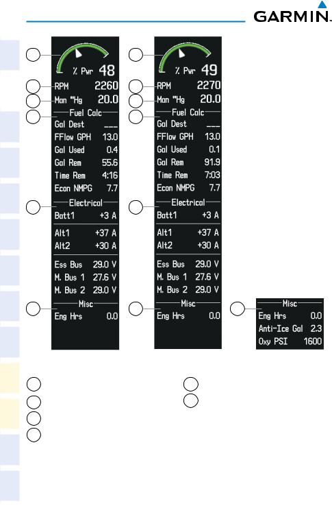
EIS
Engine Page
Pressing the ENGINE Softkey accesses the EIS - Engine Page, which displays all engine, fuel, fuel calculation, electrical, and air data information. Pressing the FUEL Softkey accesses the second-level softkeys.
1 |
2 |
3 |
4 |
5 |
6
9
7
8
(SR20)
1 |
2 |
3 |
4 |
5 |
6
9
7
10
8
(SR22)
6 |
Cirrus Perspective™ by Garmin – Cockpit Reference Guide for the SR20/SR22/SR22T |
190-00821-05 Rev. A |
EIS
4
Target Fuel Flow Indicator
9
|
10 |
|
|
|
|
|
|
11 |
|
(SR22T) |
|
|
|
|
|
|
|
|
||
1 |
Percent Power |
5 |
Oil Temperature |
9 |
Engine Temperature |
|
2 |
Indicator |
6 |
Electrical Group |
10 |
Group |
|
Tachometer |
TKS FIKI or TKS |
|||||
3 |
Manifold Pressure |
7 |
Fuel Calculation |
|
NH Fluid Quantity |
|
|
(optional) |
|||||
4 |
|
8 |
Group |
11 |
Oxygen Pressure |
|
Fuel Flow Indicator |
Air Data |
|||||
|
|
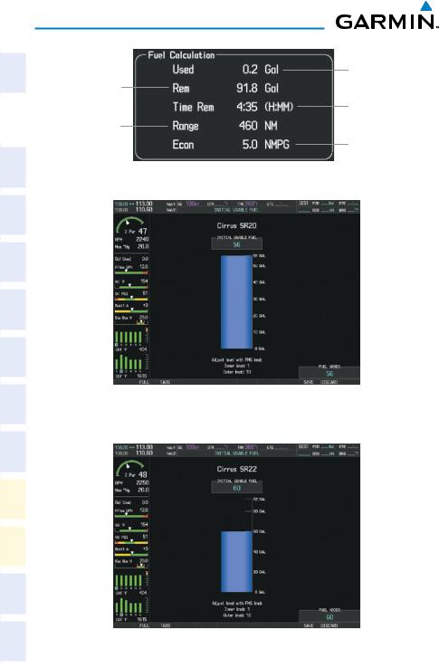
NOTE: Fuel calculations do not use the aircraft fuel quantity indicators and are calculated from the last time the fuel was reset.
Adjusting the fuel totalizer quantity:
1)Press the ENGINE Softkey to display the Engine Page.
2)Press the FUEL Softkey to access the Initial Usable Fuel Page.
3)Turn the small FMS Knob increase or decrease the initial usable fuel displayed.
Instruments |
Flight |
|
|
EIS |
|
|
|
XPDR/Audio |
Nav/Com/ |
AFCS |
|
Nav GPS |
|
Planning |
Flight |
Procedures |
|
Avoidance |
Hazard |
Features |
Additional |
Operation |
Abnormal |
Alerts |
Annun/ |
Appendix |
|
Index |
|
190-00821-05 Rev. A |
Cirrus Perspective™ by Garmin – Cockpit Reference Guide for the SR20/SR22/SR22T |
7 |
EIS
Flight |
Instruments |
|
|
|
EIS |
|
|
Nav/Com/ |
XPDR/Audio |
|
AFCS |
|
GPS Nav |
Flight |
Planning |
|
Procedures |
Hazard |
Avoidance |
Additional |
Features |
Abnormal |
Operation |
Annun/ |
Alerts |
|
Appendix |
|
Index |
Set Fuel
Remaining
Calculated
Range
Fuel Calculations Group
Full Fuel (SR20)
Initial Usable Fuel Page
Fuel to TABS (SR22) Initial Usable Fuel Page
Calculated
Fuel Used
Calculated Time
Remaining
Calculated
Economy
8 |
Cirrus Perspective™ by Garmin – Cockpit Reference Guide for the SR20/SR22/SR22T |
190-00821-05 Rev. A |
EIS
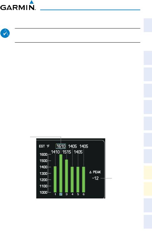
Leaning Assist Mode
NOTE: The pilot should follow the engine manufacturer’s recommended leaning procedures in the Pilot’s Operating Handbook (POH).
Accessing Leaning Assist Mode:
1)Press the ENGINE Softkey to display the Engine Page.
2)Press the ASSIST Softkey to identify peaks.
When the ASSIST Softkey is pressed, the system initially highlights the number and places a light blue box around the EGT readout of the cylinder with the hottest EGT. The ∆Peak temperature is the difference between the peak temperature and the present temperature for the peaked cylinder. When the first peak is detected, “1st” is annunciated below that cylinder’s EGT bar and the temperature is enclosed in a light blue box.
The system continues to detect peak EGTs for each cylinder lean of peak as the fuel flow is decreased, and the peak of each cylinder’s EGT is indicated by a light blue marker on the graph. Once all cylinders are lean of peak, the last cylinder to peak is denoted by the “Last” annunciation below its bar on the graph.
Light Blue Box
Represents Peak
Temperature Deviation from Peak
Leaning Assist Mode
Instruments |
Flight |
|
|
EIS |
|
|
|
XPDR/Audio |
Nav/Com/ |
AFCS |
|
Nav GPS |
|
Planning |
Flight |
Procedures |
|
Avoidance |
Hazard |
Features |
Additional |
Operation |
Abnormal |
Alerts |
Annun/ |
Appendix |
|
Index |
|
190-00821-05 Rev. A |
Cirrus Perspective™ by Garmin – Cockpit Reference Guide for the SR20/SR22/SR22T |
9 |
Flight |
Instruments |
|
|
|
EIS |
|
|
Nav/Com/ |
XPDR/Audio |
|
AFCS |
|
GPS Nav |
Flight |
Planning |
|
Procedures |
Hazard |
Avoidance |
Additional |
Features |
Abnormal |
Operation |
Annun/ |
Alerts |
|
Appendix |
|
Index |
EIS
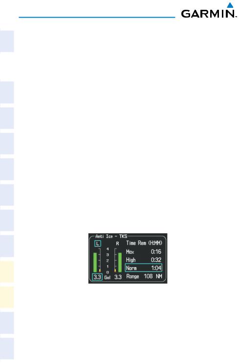
TKS FIKI Anti-ice System
In the default tank selection mode (AUTO), the system assures the fluid level in the two tanks is kept relatively even by periodically closing the tank with the lowest level. The system uses the TKS fluid tank quantity to control the tank shut-off valves. When the system is on and operating in AUTO mode, the shut-off valves close under the following conditions:
•The left and right tank tank level imbalance is greater than 0.25 gallons (low tank will be closed until level balance is within 0.15 gallons)
•The fluid quantity is empty (indicated from the fluid level sensor and level switch)
•Thefluidquantityisunreliable(amiscomparebetweenthelevelsensorandlevel switch or an out of range level sensor value)
Manual tank mode allows the pilot to control either tank’s shut-off valve. Manual may be selected by pressing the ANTI-ICE Softkey to access the second-level softkeys
LEFT, AUTO, and RIGHT.
•LEFT Softkey – opens left tank valve and closes right tank valve
•AUTO Softkey – returns to AUTO tank mode
•RIGHT Softkey – opens right tank valve and closes left tank valve
While operating in manual tank mode, only the selected/open tank’s quantity is used for the range and endurance calculations.
Manual Tank Mode (Left tank selected)
10 |
Cirrus Perspective™ by Garmin – Cockpit Reference Guide for the SR20/SR22/SR22T |
190-00821-05 Rev. A |

EIS
The TKS FIKI system consists of various operating modes, which are presented on the Perspective™ system. A white box highlights the active mode. Descriptions of the various modes are listed in the following table:
Operating Mode |
System Operation |
Comments |
OFF |
System Off |
No modes selected |
|
|
|
NORMAL |
Both pumps operate on a timed, |
Provides 50% flow rate for light/ |
|
repeating cycle – 30 seconds ON |
moderate icing |
|
and 90 seconds OFF |
|
|
|
|
HIGH |
A single primary pump (#1) |
Provides 100% flow rate for |
|
operates continuously |
moderate icing |
MAX |
Both primary pumps operate |
Provides 200% flow rate for severe |
(momentary) |
continuously for 120 seconds |
icing or to expedite the removal of |
|
|
previous ice buildup |
|
|
|
PUMP BKUP |
A single primary pump (#2) |
This mode is used in the event of a |
|
operates continuously |
timer box failure or when BKUP mode |
|
|
is selected. Pump #2 provides 100% |
|
|
flow rate, bypassing the timer box |
|
|
|
Refer to the AFM for pilot recommeneded actions |
|
|
|
|
|
System Display
NOTE: Fuel calculations do not use the aircraft fuel quantity indicators and are calculated from the last time the fuel was reset.
NOTE: Refer to the Pilot’s Operating Handbook (POH) for limitations.
Accessing the EIS System Display:
1)Press the ENGINE Softkey.
2)Press the SYSTEM Softkey.
3)To return to the default Engine Display, press the ENGINE or BACK Softkey.
Instruments |
Flight |
|
|
EIS |
|
|
|
XPDR/Audio |
Nav/Com/ |
AFCS |
|
Nav GPS |
|
Planning |
Flight |
Procedures |
|
Avoidance |
Hazard |
Features |
Additional |
Operation |
Abnormal |
Alerts |
Annun/ |
Appendix |
|
Index |
|
190-00821-05 Rev. A |
Cirrus Perspective™ by Garmin – Cockpit Reference Guide for the SR20/SR22/SR22T |
11 |
EIS
Flight |
Instruments |
|
|
|
EIS |
|
|
Nav/Com/ |
XPDR/Audio |
|
AFCS |
|
GPS Nav |
Flight |
Planning |
|
Procedures |
Hazard |
Avoidance |
Additional |
Features |
Abnormal |
Operation |
Annun/ |
Alerts |
|
Appendix |
|
Index |
1 |
1 |
2 |
2 |
3 |
3 |
4 |
4 |
5 |
5 |
6 |
6 |
SR20
1Percent Power Indicator
2Tachometer
3Manifold Pressure
4Fuel Calculation Group
6
SR22 |
Optional Equipment |
5Electrical Group
6Miscellaneous ‘Anti-Ice Gal’ and ‘Oxy PSI’ are optional on the SR22T
12 |
Cirrus Perspective™ by Garmin – Cockpit Reference Guide for the SR20/SR22/SR22T |
190-00821-05 Rev. A |

Nav/Com/XPDR/Audio Panel
Nav/Com/Transponder/Audio Panel
DME Tuning
1)Press the DME Softkey.
2)Turn the large FMS Knob to select the DME source field.
3)Turn the small FMS Knob to select the desired Nav radio.
4)Press the ENT Key to complete the selection.
Enter a Transponder Code
1)Press the XPDR Softkey to display the transponder mode selection softkeys.
2)Press the CODE Softkey to display the transponder code selection softkeys, for digit entry.
3)Press the digit softkeys to enter the code in the code field. When entering the code, the next key in sequence must be pressed within 10 seconds, or the entry is cancelled and restored to the previous code. Five seconds after the fourth digit has been entered, the transponder code becomes active.
Or:
1)Press the XPDR Key on the PFD/MFD Control Unit to select the transponder function.
2)Enter a Code with the Numeric Keypad or FMS Knob on the PFD/MFD Control Unit. Five seconds after the fourth digit has been entered, the transponder code becomes active.
Selecting a COM Radio
Transmit/Receive
Press the COM1 MIC, COM2 MIC, or COM3 MIC Key (optional COM radio, if installed) on the audio panel.
Receive Only
Press the COM1, COM2, or COM3 Key (optional COM radio, if installed) on the audio panel.
Instruments |
Flight |
EIS |
|
|
|
XPDR/Audio |
Nav/Com/ |
|
|
AFCS |
|
Nav GPS |
|
Planning |
Flight |
Procedures |
|
Avoidance |
Hazard |
Features |
Additional |
Operation |
Abnormal |
Alerts |
Annun/ |
Appendix |
|
Index |
|
190-00821-05 Rev. A |
Cirrus Perspective™ by Garmin – Cockpit Reference Guide for the SR20/SR22/SR22T |
13 |

Flight |
Instruments |
|
EIS |
|
|
Nav/Com/ |
XPDR/Audio |
|
|
|
AFCS |
|
GPS Nav |
Flight |
Planning |
|
Procedures |
Hazard |
Avoidance |
Additional |
Features |
Abnormal |
Operation |
Annun/ |
Alerts |
|
Appendix |
|
Index |
Nav/Com/XPDR/Audio Panel
Selecting a NAV Radio
1)To begin navigating using a navigation radio, press the CDI Softkey on the PFD to select VOR1/LOC1 (NAV1) or VOR2/LOC2 (NAV2).
2)Press the NAV1, NAV2, DME, or ADF Key on the audio panel to select or deselect the navigation radio audio source. All radio keys can be selected individually or together.
NAV/COM Tuning
1)Turn the respective tuning knobs to enter the desired frequency into the standby frequency field. The large knob enters MHz and the small knob enters kHz.
2)Press the appropriate Frequency Transfer Key to place the frequency into the active frequency field.
Or:
1)Press the COM or NAV Key on the PFD/MFD Control Unit to select the desired COM or NAV frequency box.
2)Turn the FMS/XPDR COM/NAV Knob to tune the desired frequency (large knob for MHz; small knob for kHz).
3)Press the Frequency Transfer Key to transfer the frequency to the active field.
Intercom System (ICS) Isolation
Press the PILOT and/or COPLT Key on the audio panel to select those isolated from hearing the Nav/Com radios and music.
14 |
Cirrus Perspective™ by Garmin – Cockpit Reference Guide for the SR20/SR22/SR22T |
190-00821-05 Rev. A |
Loading...