


RV-IN1501 RV INFOTAINMENT SYSTEM
Owner’s Manual

© 2018 Garmin Ltd. or its subsidiaries
All rights reserved. Under the copyright laws, this manual may not be copied, in whole or in part, without the written consent of Garmin. Garmin reserves the right to change or improve its
products and to make changes in the content of this manual without obligation to notify any person or organization of such changes or improvements. Go to www.garmin.com for current updates
and supplemental information concerning the use of this product.
Garmin®, the Garmin logo, FUSION®, and the Fusion logo are trademarks of Garmin Ltd. or its subsidiaries, registered in the USA and other countries. Apollo™, Connect IQ™, FUSION-Link™,
FUSION-Link Lite™, FUSION PartyBus™, and myTrends™ are trademarks of Garmin Ltd. or its subsidiaries. These trademarks may not be used without the express permission of Garmin.
Android™ and Google Play™ are a trademarks of Google Inc. Apple®, the Apple logo, iPod®, and Mac® are trademarks of Apple Inc., registered in the U.S. and other countries. BLUETOOTH® word
mark and logos are owned by the Bluetooth SIG, Inc. and any use of such marks by Garmin is under license. Foursquare® is a trademark of Foursquare Labs, Inc. in the U.S. and in other
countries. microSD® and the microSDHC logo are trademarks of SD-3C, LLC. SiriusXM®, SportsFlash™, TuneMix™, TuneStart™, and all related marks and logos are trademarks of Sirius XM
Radio Inc. All rights reserved. Wi‑Fi® is a registered trademark of Wi-Fi Alliance Corporation. Windows® is a registered trademark of Microsoft Corporation in the United States and other countries.

Table of Contents
Getting Started............................................................... 1
Front Panel Overview................................................................. 1
Acquiring GPS Signals............................................................... 1
Home Screen.............................................................................. 1
Opening an App..................................................................... 1
Adding Shortcuts to the Home Screen.................................. 1
Viewing Notifications.............................................................. 1
Status Bar Icons.....................................................................1
Using the Touchscreen............................................................... 2
Adjusting the Screen Brightness................................................ 2
Vehicle Profiles............................................................... 2
Car Profile................................................................................... 2
Adding a Vehicle Profile..............................................................2
Activating a Vehicle Profile......................................................... 2
Editing a Vehicle Profile.............................................................. 2
Driver Awareness Features and Alerts........................ 2
Enabling or Disabling Audible Driver Alerts................................ 3
Red Light and Speed Cameras.................................................. 3
Navigating to Your Destination..................................... 3
Routes........................................................................................ 3
Starting a Route.......................................................................... 3
Starting a Route by Using the Map........................................ 3
Going Home........................................................................... 3
Editing Your Home Location............................................. 3
Your Route on the Map...............................................................3
Active Lane Guidance............................................................ 4
Viewing Turns and Directions................................................ 4
Viewing the Entire Route on the Map.................................... 4
Arriving at Your Destination........................................................ 4
Changing Your Active Route...................................................... 4
Adding a Location to Your Route........................................... 4
Shaping Your Route...............................................................4
Taking a Detour..................................................................... 5
Changing the Route Calculation Mode.................................. 5
Stopping the Route..................................................................... 5
Using Suggested Routes............................................................ 5
Avoiding Delays, Tolls, and Areas.............................................. 5
Avoiding Traffic Delays on Your Route.................................. 5
Avoiding Toll Roads............................................................... 5
Avoiding Toll Stickers.............................................................5
Avoiding Road Features........................................................ 5
Avoiding Environmental Zones.............................................. 5
Custom Avoidances............................................................... 5
Avoiding a Road................................................................ 5
Avoiding an Area............................................................... 6
Disabling a Custom Avoidance......................................... 6
Deleting Custom Avoidances............................................ 6
Finding and Saving Locations...................................... 6
Points of Interest......................................................................... 6
Finding RV Parks........................................................................ 6
Finding RV Services................................................................... 6
Finding a Location Using the Search Bar................................... 6
Finding an Address..................................................................... 6
Finding a Location by Category.................................................. 6
Searching Within a Category................................................. 6
Location Search Results............................................................. 7
Location Search Results on the Map..................................... 7
Changing the Search Area......................................................... 7
Custom Points of Interest........................................................... 7
Installing POI Loader............................................................. 7
Finding Custom POIs............................................................. 7
Parking Your Vehicle.................................................................. 7
Search Tools...............................................................................7
Finding an Intersection
Finding a City......................................................................... 7
Finding a Location Using Coordinates................................... 7
Viewing Recently Found Locations............................................ 7
Clearing the List of Recently Found Locations...................... 8
Viewing Current Location Information........................................ 8
Finding Emergency Services and Fuel.................................. 8
Getting Directions to Your Current Location.......................... 8
Adding a Shortcut....................................................................... 8
Removing a Shortcut............................................................. 8
Saving Locations........................................................................ 8
Saving a Location.................................................................. 8
Saving Your Current Location................................................ 8
Editing a Saved Location....................................................... 8
Assigning Categories to a Saved Location............................ 8
Deleting a Saved Location..................................................... 8
...........................................................7
Using the Map................................................................. 8
Map Tools................................................................................... 8
Viewing a Map Tool............................................................... 9
Enabling Map Tools............................................................... 9
Up Ahead.................................................................................... 9
Viewing Upcoming Locations................................................. 9
Customizing the Up Ahead Categories.................................. 9
Warning and Alert Symbols........................................................ 9
Restriction Warnings.............................................................. 9
Road Condition Warnings...................................................... 9
Alerts...................................................................................... 9
Trip Information...........................................................................9
Viewing Trip Data from the Map............................................ 9
Customizing the Trip Data Fields...................................... 9
Viewing the Trip Information Page....................................... 10
Viewing the Trip Log............................................................ 10
Resetting Trip Information....................................................10
Viewing Upcoming Traffic......................................................... 10
Viewing Traffic on the Map.................................................. 10
Searching for Traffic Incidents............................................. 10
Customizing the Map................................................................ 10
Customizing the Map Layers............................................... 10
Changing the Map Data Field.............................................. 10
Changing the Map Perspective............................................ 10
Live Services, Traffic, and Smartphone Features..... 10
Pairing Your Phone for Live Services and Hands-Free
Calling....................................................................................... 10
Tips After Pairing the Devices..............................................10
Pairing Additional Bluetooth Devices................................... 11
Garmin Live Services................................................................11
Subscribing to Garmin Live Services................................... 11
Sending a Location from Your Smartphone to Your Device..... 11
Smart Notifications....................................................................11
Receiving Smart Notifications.............................................. 11
Hands-Free Calling................................................................... 11
Placing a Call....................................................................... 11
Receiving a Call................................................................... 11
Using In-Call Options........................................................... 11
Saving a Phone Number as a Preset.................................. 12
Wireless Headsets.................................................................... 12
Enabling or Disabling Bluetooth Features................................ 12
Showing or Hiding Notifications for Your Smartphone with
Android™............................................................................. 12
Showing or Hiding Notification Categories for Your Apple®
Device.................................................................................. 12
Disconnecting a Bluetooth Device............................................ 12
Deleting a Paired Bluetooth Device.......................................... 12
Deleting a Paired Phone........................................................... 12
Media Playback............................................................. 12
Table of Contents i

Playing Media........................................................................... 12
Music Player Overview............................................................. 12
Selecting a Source............................................................... 13
Playback Controls................................................................ 13
Media Player Connection..........................................................13
USB Device Compatibility.................................................... 13
Playing Media from a USB Device.................................. 13
Connecting an Auxiliary Device........................................... 13
Connecting to a Garmin Watch............................................ 13
Connecting a UPnP Device................................................. 14
Audio Control............................................................................ 14
Adjusting the Volume for a Zone......................................... 14
Muting all Connected Stereos......................................... 14
Adjusting the Tones............................................................. 14
Disabling the Loud Setting for a Zone................................. 14
Adjusting the Gain for an Auxiliary Device........................... 14
Speaker Zones.....................................................................14
Adjusting the Audio Settings for a Zone.......................... 14
Adjusting the Subwoofer Filter........................................ 14
DSP Settings........................................................................14
Configuring the DSP Settings......................................... 14
Bluetooth Device Playback....................................................... 14
Connecting a Compatible Bluetooth Device........................ 15
Bluetooth Range Information.......................................... 15
Selecting a Different Bluetooth Source................................ 15
Bluetooth Source Settings................................................... 15
USB Device Playback............................................................... 15
Controlling Music Playback on a Connected Android Device,
USB Flash Drive, or Media Player....................................... 15
Controlling Music Playback on a Connected Apple
.................................................................................. 15
Device
Radio........................................................................................ 15
Setting the Tuner Region..................................................... 15
Changing the Radio Station................................................. 15
SiriusXM Satellite Radio........................................................... 16
Enabling the SiriusXM Source............................................. 16
Locating the SiriusXM Radio ID........................................... 16
Activating a SiriusXM Subscription...................................... 16
Selecting a Category............................................................16
Using Replay Mode..............................................................16
Alerts.................................................................................... 16
Adding an Artist or Song Alert......................................... 16
Adding Teams for Game Alerts....................................... 16
Viewing Active Alerts.......................................................16
Managing Alerts.............................................................. 16
TuneMix™ Feature.............................................................. 17
Starting and Stopping a TuneMix Collection................... 17
Creating and Customizing a TuneMix Collection............ 17
SportsFlash Feature............................................................ 17
Adding Teams to Receive SportsFlash Alerts.................17
Changing SportsFlash Team Priority.............................. 17
Enabling the TuneStart™ Feature....................................... 17
Parental Controls................................................................. 17
Unlocking the Parental Controls......................................17
Locking Channels............................................................17
Clearing All Locked Channels......................................... 17
Changing the Parental Control Passcode....................... 17
SiriusXM Troubleshooting.................................................... 18
Clearing SiriusXM Data................................................... 18
Presets......................................................................................18
Saving a Station as a Preset............................................... 18
Selecting a Preset from a List.............................................. 18
Removing Presets................................................................18
FUSION PartyBus™ Networking.............................................. 18
Streaming from a FUSION PartyBus Device on the
Network................................................................................ 19
Stopping Streaming from a FUSION PartyBus Device on the
Network................................................................................ 19
Network UPnP Playback...................................................... 19
Audio Settings...........................................................................19
Speaker Zone Settings........................................................ 19
Setting a Zone Name...................................................... 19
Linking Zones.................................................................. 19
Enabling Volume Control of Zone 3 or 4 from a Connected
Amplifier.......................................................................... 19
Disabling a Zone............................................................. 19
Disabling the Internal Amplifiers......................................19
Network Configuration......................................................... 19
Setting the FUSION PartyBus Device as the DHCP
Server..............................................................................19
Setting the FUSION PartyBus Device as a Wireless
Access Point................................................................... 20
Connecting the FUSION PartyBus Device to a Wireless
Access Point................................................................... 20
Advanced Network Configuration................................... 20
Resetting Network Settings............................................. 20
Additional Stereo Control Options............................................ 20
FUSION-Link Wireless Remote Control App....................... 20
Resetting the Stereo Settings................................................... 21
Vehicle Cameras........................................................... 21
Viewing a Vehicle Camera........................................................21
Enabling Camera Auto-Display.................................................21
Flipping the Camera Image...................................................... 21
Enabling the Vehicle Camera Microphone............................... 21
Traffic............................................................................ 21
Receiving Traffic Data Using Smartphone Link........................ 21
Enabling Traffic......................................................................... 21
Viewing Traffic on the Map....................................................... 21
Searching for Traffic Incidents............................................. 22
Voice Command........................................................... 22
Setting the Wakeup Phrase...................................................... 22
Activating Voice Command.......................................................22
Voice Command Tips............................................................... 22
Starting a Route Using Voice Command.................................. 22
Muting Instructions....................................................................22
Using the Apps............................................................. 22
Viewing the Owner's Manual on Your Device........................... 22
LiveTrack.................................................................................. 22
Setting Up LiveTrack Sharing and Inviting Viewers............. 22
Starting LiveTrack Sharing...................................................22
Stopping LiveTrack Sharing............................................ 23
Trip Planner.............................................................................. 23
Planning a Trip..................................................................... 23
Editing and Reordering Locations in a Trip.......................... 23
Optimizing the Order of Destinations in a Trip................ 23
Discovering Attractions Along Your Trip.............................. 23
Changing Routing Options for a Trip................................... 23
Navigating to a Saved Trip...................................................23
Editing and Saving Your Active Route................................. 23
Viewing Previous Routes and Destinations.............................. 23
Viewing the Weather Forecast..................................................23
Viewing Weather Near a Different City................................ 23
RV-IN1501 Settings...................................................... 24
Navigation Settings................................................................... 24
Map and Vehicle Settings.................................................... 24
Enabling Maps................................................................ 24
Route Preference Settings................................................... 24
Driver Assistance Settings................................................... 24
Traffic Settings..................................................................... 24
Enabling Bluetooth Wireless Technology................................. 24
ii Table of Contents

Connecting to a Wireless Network............................................24
Display Settings........................................................................ 24
Sound and Notification Settings............................................... 24
Adjusting Sound and Notification Volume............................ 24
Enabling or Disabling Location Services.................................. 24
Setting the Text Language....................................................... 25
Adding Accounts....................................................................... 25
Date and Time Settings............................................................ 25
Device Settings......................................................................... 25
Restoring Settings.................................................................... 25
Device Information....................................................... 25
Viewing E-label Regulatory and Compliance Information........ 25
Specifications............................................................................25
Device Maintenance..................................................... 25
Garmin Support Center.............................................................25
Map and Software Updates...................................................... 25
Updating Maps and Software Using a Wi‑Fi Network.......... 26
Installing Software Updates Using a Memory Card............. 26
Loading Software Updates to a Memory Card................ 26
Installing Garmin Express............................................... 26
Device Care.............................................................................. 26
Cleaning the Touchscreen................................................... 26
Troubleshooting........................................................... 26
My device is not acquiring satellite signals............................... 26
My device does not connect to my phone or Smartphone
Link........................................................................................... 26
My phone is not listed as a Bluetooth audio source................. 27
Network Troubleshooting.......................................................... 27
Network Status Icons........................................................... 27
Appendix....................................................................... 27
Connecting to a Wireless Display............................................. 27
Data Management.................................................................... 27
About Memory Cards........................................................... 27
Purchasing Additional Maps..................................................... 27
Purchasing Accessories........................................................... 27
Index.............................................................................. 28
Table of Contents iii

Getting Started
WARNING
See the Important Safety and Product Information guide in the
product box for product warnings and other important
information.
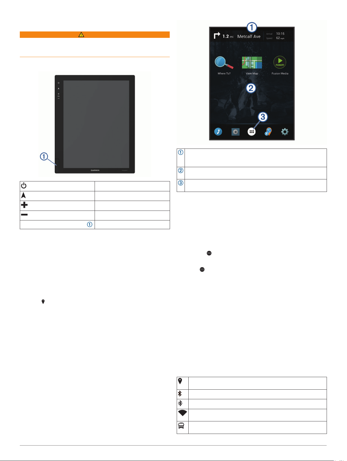
Front Panel Overview
Turns the screen on or off.
Opens the navigation map.
Increases the volume.
Decreases the volume.
Memory card slot (under cover)
Acquiring GPS Signals
When you turn on your navigation device, the GPS receiver
must collect satellite data and establish the current location. The
time required to acquire satellite signals varies based on several
factors, including how far you are from the location where you
last used your navigation device, whether you have a clear view
of the sky, and how long it has been since you last used your
navigation device. The first time you turn on your navigation
device, it may take several minutes to acquire satellite signals.
Turn on the device.
1
Verify appears in the status bar, and enable location
2
services if it does not (Enabling or Disabling Location
Services, page 24).
If necessary, go to an open area with a clear view of the sky,
3
away from tall buildings and trees.
Acquiring Satellites appears at the top of the navigation map
until the device determines your location.
Home Screen
NOTE: The home screen layout may vary if it has been
customized.
Accepts SDHC cards up to 32 GB.
Swipe down to view notifications.
Swipe down twice to quickly change settings and backlight
brightness.
Hold to customize the wallpaper or add widgets to the home
screen.
Select to open the app drawer. The app drawer contains shortcuts
to all the apps installed on your device.
Opening an App
The home screen contains shortcuts for frequently used apps.
The app drawer contains all the apps installed on your device,
organized into two tabs. The Navigation tab contains Garmin
®
apps useful for navigation. The Tools tab contains apps useful
for communication, document viewing, and other tasks.
Select an option to start an app:
• Select an app shortcut from the home screen.
• Select , select a tab, and select an app.
Adding Shortcuts to the Home Screen
Select .
1
Select the Navigation or Tools tab to view additional
2
applications.
Hold an application, and drag it to a location on the home
3
screen.
Viewing Notifications
Swipe down from the top of the screen.
1
The list of notifications appears.
Select an option:
2
• To launch the action or app mentioned in the notification,
select the notification.
• To dismiss a notification, swipe the notification to the right.
Status Bar Icons
The status bar is located at the top of the main menu. The status
bar icons display information about features on the device.
Location services is enabled (Enabling or Disabling Location
Services, page 24).
Bluetooth® technology is enabled.
Connected to a Bluetooth device.
Connected to a Wi‑Fi® network (Connecting to a Wireless
Network, page 24).
Active vehicle profile. Swipe down twice and select to view the
vehicle profile settings (Vehicle Profiles, page 2).
Getting Started 1

Using the Touchscreen
• Tap the screen to select an item.
• Drag or swipe your finger across the screen to pan or scroll.
• Pinch two fingers together to zoom out.
• Spread two fingers apart to zoom in.
Adjusting the Screen Brightness
You can adjust the brightness using either the notification panel
or the settings menu.
Select an option:
1
• Swipe down twice from the top of the screen to expand
the quick settings in the notification panel.
• Select > Display > Brightness Level.
Use the slider bar to adjust the brightness.
2
Vehicle Profiles
WARNING
Entering your vehicle profile characteristics does not guarantee
that your vehicle's characteristics will be accounted for in all
route suggestions or that you will receive the warning icons in all
cases. Limitations may exist in the map data such that your
device cannot account for these restrictions or road conditions in
all cases. Always defer to all posted road signs and road
conditions when making driving decisions.
Routing and navigation are calculated differently based on your
vehicle profile. The activated vehicle profile is indicated by an
icon in the status bar. The navigation and map settings on your
device can be customized separately for each vehicle type.
When you activate a camper vehicle profile, the device avoids
including restricted or impassable areas in routes based on the
dimensions, weight, and other characteristics you entered for
your vehicle.
Car Profile
The car profile is a preloaded vehicle profile intended for use in
an automobile. While using the car profile, the device calculates
standard automobile routes, and routing for large vehicles is not
available. Some features and settings specific to large vehicles
are not available while using the car profile.
Adding a Vehicle Profile
You should add a vehicle profile for each camper to be used
with your RV-IN1501 device.
Select > Navigation > Vehicle Profile > .
1
Select an option:
2
• To add a motorhome with a permanently attached
camper, select Motorhome.
• To add a camper pulled behind a vehicle using a standard
hitch, select Trailer.
• To add a camper pulled behind a truck using a fifth-wheel
hitch, select Fifth Wheel.
Follow the on-screen instructions to enter the vehicle
3
characteristics.
After you add a vehicle profile, you can edit the profile to enter
additional detailed information, such as the vehicle identification
number or trailer number (Editing a Vehicle Profile, page 2).
Activating a Vehicle Profile
Select > Navigation > Vehicle Profile.
1
Select a vehicle profile.
2
The vehicle profile information appears, including
measurements and weight.
Select Select.
3
Editing a Vehicle Profile
You can change basic vehicle profile information or add detailed
information to a vehicle profile, such as maximum speed.
Select > Navigation > Vehicle Profile.
1
Select the vehicle profile to edit.
2
Select an option:
3
• To edit the vehicle profile information, select , and select
a field to edit.
• To rename a vehicle profile, select > > Rename
Profile.
• To delete the vehicle profile, select > > Delete.
Driver Awareness Features and Alerts
NOTICE
The driver alerts and speed limit features are for information
only and do not replace your responsibility to abide by all posted
speed limit signs and to use safe driving judgment at all times.
Garmin is not responsible for any traffic fines or citations you
receive for failing to follow all applicable traffic laws and signs.
Your device provides features that can help encourage safer
driving and increase efficiency, even when you are driving in a
familiar area. The device plays an audible tone or message and
displays information for each alert. You can enable or disable
the audible tone for some types of driver alerts. Not all alerts are
available in all areas.
Schools: The device plays a tone and displays the distance to
and speed limit (if available) for an upcoming school or
school zone.
Speed limit reduction: The device plays a tone and displays
the upcoming reduced speed limit so you can be prepared to
reduce your speed.
Speed limit exceeded: The device plays a tone and displays a
red border on the speed limit icon when you exceed the
posted speed limit for the current road.
Speed limit change: The device plays a tone and displays the
upcoming speed limit so you can be prepared to adjust your
speed.
Railroad crossing: The device plays a tone and displays the
distance to an upcoming railroad crossing.
Animal crossing: The device plays a tone and displays the
distance to an upcoming animal crossing area.
Curves: The device plays a tone and displays the distance to a
curve in the road.
Slower traffic: The device plays a tone and displays the
distance to slower traffic when you approach slower traffic at
a higher speed. Your device must be receiving traffic
information to use this feature (Traffic, page 21).
No trucks allowed: The device plays a tone when you
approach a road where no trucks are allowed.
Risk of grounding: The device plays a tone and displays a
message when you approach a road where your vehicle
could become grounded.
Lateral wind: The device plays a tone and displays a message
when you approach a road where there is risk of lateral wind.
Narrow road: The device plays a tone and displays a message
when you approach a road that may be too narrow for your
vehicle.
Steep hill: The device plays a tone and displays a message
when you approach a steep hill.
2 Vehicle Profiles

State and country borders: The device plays a tone and
displays a message when you approach the border of a state
or country.
Shut off propane: The device plays a tone and displays a
message when you approach an area where propane should
be turned off.
Enabling or Disabling Audible Driver Alerts
You can enable or disable the audible tone for some types of
driver alerts. The visual alert appears even when the tone is
disabled.
Select > Navigation > Driver Assistance > Audible
1
Driver Alerts.
Select or clear the check box next to each alert.
2
Red Light and Speed Cameras
NOTICE
Garmin is not responsible for the accuracy of or the
consequences of using a red light or speed camera database.
NOTE: This feature is not available for all regions or product
models.
Information about red light and speed camera locations is
available in some areas for some product models. The device
alerts you when you approach a reported speed or red light
camera.
• Live red light and safety camera data is available as a
subscription from Garmin Live Services using the
Smartphone Link app (Garmin Live Services, page 11).
• To maintain an updated database of red light and speed
camera locations, your device must have an active
subscription to download and store safety camera data. Go to
garmin.com/speedcameras to check availability and
compatibility, or to purchase a subscription or one-time
update. You can purchase a new region or extend an existing
subscription at any time.
NOTE: In some regions, some product bundles include preloaded red light and speed camera data with subscriptionfree updates.
• You can use the Garmin Express™ software (garmin.com
/express) to update the camera database stored on your
device. You should update your device frequently to receive
the most up-to-date camera information.
Starting a Route
Select Where To?, and search for a location (Finding and
1
Saving Locations, page 6).
Select a location.
2
Select an option:
3
• To start navigating using the recommended route, select
Go!.
• To choose an alternate route, select , and select a route.
Alternate routes appear to the right of the map.
• To edit the course of the route, select > Edit Route, and
add shaping points to the route (Shaping Your Route,
page 4).
The device calculates a route to the location and guides you
using voice prompts and information on the map (Your Route on
the Map, page 3). A preview of the major roads in your route
appears at the edge of the map for several seconds.
If you need to stop at additional destinations, you can add the
locations to your route (Adding a Location to Your Route,
page 4).
Starting a Route by Using the Map
You can start route by selecting a location from the map.
Select View Map.
1
Drag and zoom the map to display the area to search.
2
If necessary, select to filter the displayed points of interest
3
by category.
Location markers ( or a blue dot) appear on the map.
Select an option:
4
• Select a location marker.
• Select a point, such as a street, intersection, or address
location.
Select Go!.
5
Going Home
The first time you start a route home, the device prompts you to
enter your home location.
Select Where To? > Go Home.
1
If necessary, enter your home location.
2
Editing Your Home Location
Select Where To? > > Set Home Location.
1
Enter your home location.
2
Navigating to Your Destination
Routes
A route is a path from your current location to one or more
destinations.
• The device calculates a recommended route to your
destination based on the preferences you set, including the
route calculation mode (Changing the Route Calculation
Mode, page 5) and avoidances (Avoiding Delays, Tolls,
and Areas, page 5).
• The device can automatically avoid roads that are not
appropriate for the active vehicle profile.
• You can start navigating to your destination quickly using the
recommended route, or you can select an alternate route
(Starting a Route, page 3).
• If there are specific roads you need to use or avoid, you can
customize the route (Shaping Your Route, page 4).
• You can add multiple destinations to a route (Adding a
Location to Your Route, page 4).
Navigating to Your Destination 3
Your Route on the Map
As you travel, the device guides you to your destination using
voice prompts and information on the map. Instructions for your
next turn or exit, or other actions appear across the top of the
map.
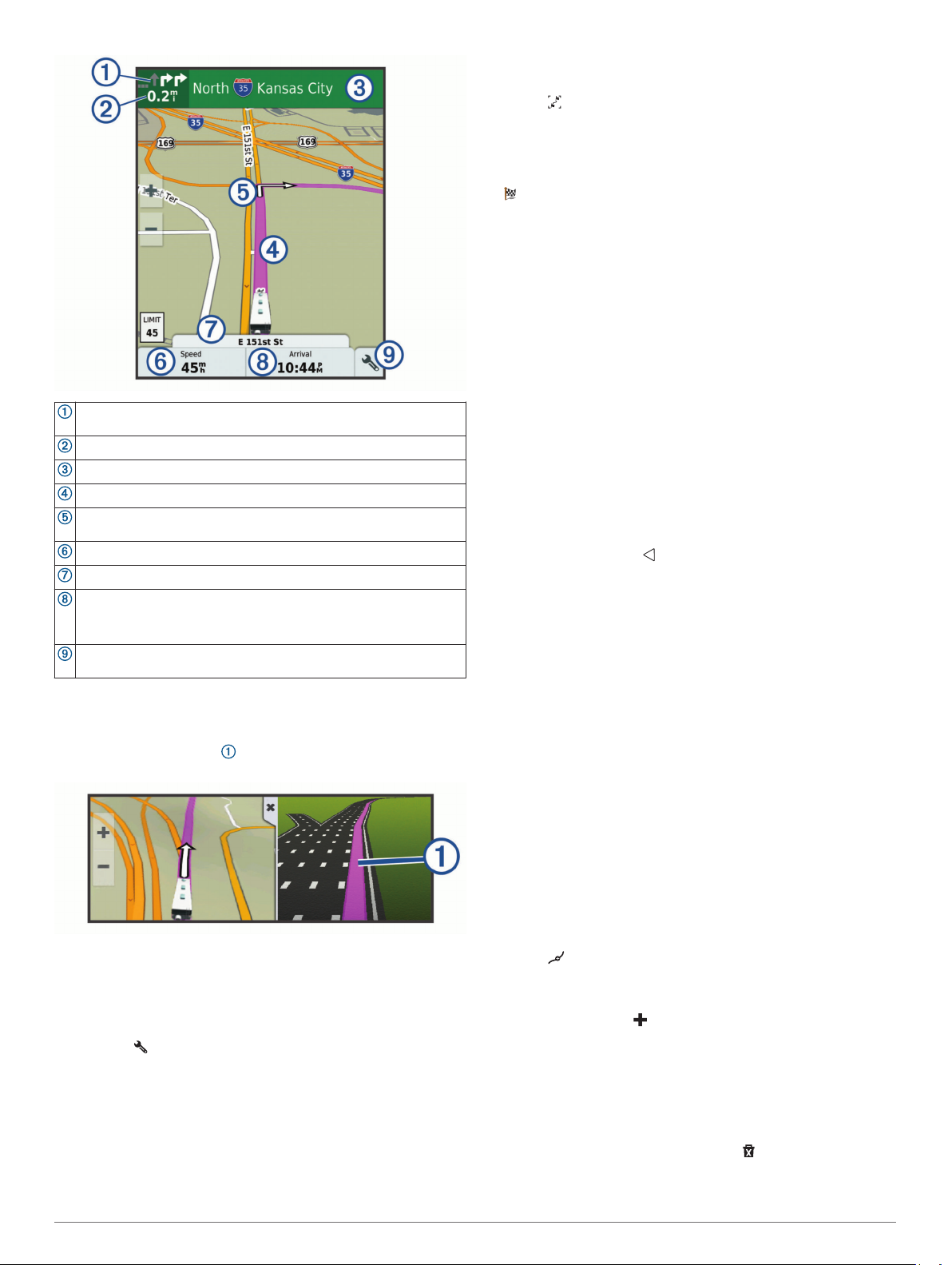
Viewing the Entire Route on the Map
While navigating a route, select anywhere on the map.
1
Select .
2
Arriving at Your Destination
When you approach your destination, the device provides
information to help you complete your route.
• indicates the location of your destination on the map, and a
voice prompt announces you are approaching your
destination.
• When you approach some destinations, the device
automatically prompts you to search for parking. You can
select Yes to find nearby parking areas .
• When you stop at your destination, the device automatically
ends the route. If the device does not detect your arrival
automatically, you can select Stop to end your route.
Changing Your Active Route
Next action in the route. Indicates the next turn, exit, or other action
and the lane in which you should travel, if available.
Distance to the next action.
Name of the street or exit associated with the next action.
Route highlighted on the map.
Next action in the route. Arrows on the map indicate the location of
upcoming actions.
Vehicle speed.
Name of the road on which you are traveling.
Estimated arrival time.
TIP: You can touch this field to change the information it shows
(Changing the Map Data Field, page 10).
Map tools. Provides tools to show you more information about your
route and surroundings.
Active Lane Guidance
As you approach some turns, exits, or interchanges in your
route, a detailed simulation of the road appears beside the map,
if available. A colored line indicates the proper lane for the
turn.
Viewing Turns and Directions
While navigating a route, you can view upcoming turns, lane
changes, or other directions for your route.
From the map, select an option:
1
• To view upcoming turns and directions as you navigate,
select > Turns.
The map tool displays the next four turns or directions
beside the map. The list updates automatically as you
navigate the route.
• To view the complete list of turns and directions for the
entire route, select the text bar at the top of the map.
Select a turn or direction (optional).
2
Detailed information appears. An image of the junction may
appear for junctions on major roadways, if available.
Adding a Location to Your Route
Before you can add a location to your route, you must be
navigating a route (Starting a Route, page 3).
You can add locations to the middle or end of your route. For
example, you can add a fuel station as the next destination in
your route.
TIP: To create complex routes with multiple destinations or
scheduled stops, you can use the trip planner to plan, schedule,
and save a trip (Planning a Trip, page 23).
From the map, select > Where To?.
1
Search for a location (Finding and Saving Locations,
2
page 6).
Select a location.
3
Select Go!.
4
Select an option:
5
• To add the location as the next destination in your route,
select Add As Next Stop.
• To add the location to the end of your route, select Add
As Last Stop.
• To add the location and edit the order of destinations in
your route, select Add to Active Route.
The device re-calculates the route to include the added location
and guides you to the destinations in order.
Shaping Your Route
Before you can shape your route, you must start a route
(Starting a Route, page 3).
You can manually shape your route to change its course. This
allows you to direct the route to use a certain road or go through
a certain area without adding a destination to the route.
Touch anywhere on the map.
1
Select .
2
The device enters route shaping mode.
Select a location on the map.
3
TIP: You can select to zoom in on the map and select a
more precise location.
The device recalculates the route to travel through the
selected location.
If necessary, select an option:
4
• To add more shaping points to the route, select additional
locations on the map.
• To remove a shaping point, select .
When you are finished shaping the route, select Go!.
5
4 Navigating to Your Destination

Taking a Detour
You can take a detour for a specified distance along your route
or detour around specific roads. This is useful if you encounter
construction zones, closed roads, or poor road conditions.
From the map, select > Change Route.
1
TIP: If the Change Route tool is not in the map tools menu,
you can add it (Enabling Map Tools, page 9).
Select an option:
2
• To detour your route for a specific distance, select Detour
by Distance.
• To detour around a specific road on the route, select
Detour by Road.
• To find a new route, select Detour.
Changing the Route Calculation Mode
Select > Navigation > Route Preferences > Calculation
1
Mode.
Select an option:
2
• Select Faster Time to calculate routes that are faster to
drive but can be longer in distance.
• Select Off Road to calculate point-to-point routes (without
roads).
• Select Shorter Distance to calculate routes that are
shorter in distance but can take more time to drive.
Stopping the Route
• From the map, select > .
• From the notification bar, swipe down, and select in the
Garmin Navigation notification.
Using Suggested Routes
Before you can use this feature, you must save at least one
location and enable the travel history feature (Device Settings,
page 25).
Using the myTrends™ feature, your device predicts your
destination based on your travel history, the day of the week,
and the time of day. After you have driven to a saved location
several times, the location may appear in the navigation bar on
the map, along with the estimated time of travel, and traffic
information.
Select the navigation bar to view a suggested route to the
location.
Avoiding Delays, Tolls, and Areas
Avoiding Traffic Delays on Your Route
Before you can avoid traffic delays, you must be receiving traffic
information (Receiving Traffic Data Using Smartphone Link,
page 21).
By default, the device optimizes your route to avoid traffic delays
automatically. If you have disabled this option in the traffic
settings (Traffic Settings, page 24), you can view and avoid
traffic delays manually.
While navigating a route, select > Traffic.
1
Select Alternate Route, if available.
2
Select Go!.
3
Avoiding Toll Roads
Your device can avoid routing you through areas that require
tolls, such as toll roads, toll bridges, or congestion areas. The
device may still include a toll area in your route if no other
reasonable routes are available.
Select > Navigation > Route Preferences.
1
Select an option:
2
NOTE: The menu changes based on your area and the map
data on your device.
• Select Toll Roads.
• Select Tolls and Fees > Toll Roads.
Select an option:
3
• To be asked each time before routing through a toll area,
select Always Ask.
• To always avoid tolls, select Avoid.
• To always allow tolls, select Allow.
Select Save.
4
Avoiding Toll Stickers
If the map data on your device contains detailed toll sticker
information, you can avoid or allow roads that require toll
stickers for each country.
NOTE: This feature is not available in all areas.
Select > Navigation > Route Preferences > Tolls and
1
Fees > Toll Stickers.
Select a country.
2
Select an option:
3
• To be asked each time before routing through an area that
requires toll stickers, select Always Ask.
• To always avoid roads that require toll stickers, select
Avoid.
• To always allow roads that require toll stickers, select
Allow.
Select Save.
4
Avoiding Road Features
Select > Navigation > Route Preferences > Avoidances.
1
Select the road features to avoid on your routes, and select
2
OK.
Avoiding Environmental Zones
Your device can avoid areas with environmental or emissions
restrictions that may apply to your vehicle. This option applies to
the vehicle type in the active vehicle profile (Vehicle Profiles,
page 2).
Select > Navigation > Route Preferences >
1
Environmental Zones.
Select an option:
2
• To be asked each time before routing through an
environmental zone, select Always Ask.
• To always avoid environmental zones, select Avoid.
• To always allow environmental zones, select Allow.
Select Save.
3
Custom Avoidances
Custom avoidances allow you select specific areas or sections
of road to avoid. When the device calculates a route, it avoids
these areas and roads unless no other reasonable route is
available.
Avoiding a Road
Select > Navigation > Route Preferences > Custom
1
Avoidances.
If necessary, select Add Avoidance.
2
Select Add Avoid Road.
3
Select the starting point of the section of road to avoid, and
4
select Next.
Select the ending point of the road section, and select Next.
5
Select Done.
6
Navigating to Your Destination 5

Avoiding an Area
Select > Navigation > Route Preferences > Custom
1
Avoidances.
If necessary, select Add Avoidance.
2
Select Add Avoid Area.
3
Select the upper-left corner of the area to avoid, and select
4
Next.
Select the lower-right corner of the area to avoid, and select
5
Next.
The selected area is shaded on the map.
Select Done.
6
Disabling a Custom Avoidance
You can disable a custom avoidance without deleting it.
Select > Navigation > Route Preferences > Custom
1
Avoidances.
Select an avoidance.
2
Select > Disable.
3
Deleting Custom Avoidances
Select > Navigation > Route Preferences > Custom
1
Avoidances.
Select an option:
2
• To delete all custom avoidances, select .
• To delete one custom avoidance, select the avoidance,
and select > Delete.
Finding and Saving Locations
The maps loaded in your device contain locations, such as
restaurants, hotels, auto services, and detailed street
information. The Where To? menu helps you find your
destination by providing several methods to browse, search, and
save this information.
• Enter search terms to quickly search all location information
(Finding a Location Using the Search Bar, page 6).
• Browse or search pre-loaded points of interest by category
(Points of Interest, page 6).
• Use search tools to find specific locations, such as
addresses, intersections, or geographic coordinates (Search
Tools, page 7).
• Search near a different city or area (Changing the Search
Area, page 7).
• Save your favorite locations to find them quickly in the future
(Saving Locations, page 8).
• Return to recently found locations (Viewing Recently Found
Locations, page 7).
Points of Interest
A point of interest is a place that you may find useful or
interesting. Points of interest are organized by category and can
include popular travel destinations such as gas stations,
restaurants, hotels, and entertainment venues.
Finding RV Parks
NOTE: This feature is not available in all areas.
You can search for RV parks based on the amenities available.
Select Where To? > RV Parks.
1
If necessary, select Filter by Amenities, select one or more
2
amenities, and select Save.
Select a location.
3
You can find nearby locations that offer repair, towing, and other
services for RVs.
Select Where To? > RV Services.
Finding a Location Using the Search Bar
You can use the search bar to search for locations by entering a
category, brand name, address, or city name.
Select Where To?.
1
Select Enter Search in the search bar.
2
Enter all or part of the search term.
3
Suggested search terms appear below the search bar.
Select an option:
4
• To search for a type of business, enter a category name
(for example, "movie theaters").
• To search for a business name, enter all or part of the
name.
• To search for an address near you, enter the house
number and street name.
• To search for an address in another city, enter the house
number, street name, city, and state.
• To search for a city, enter the city and state.
• To search for coordinates, enter latitude and longitude
coordinates.
Select an option:
5
• To search using a suggested search term, select the term.
• To search using the text you entered, select .
If necessary, select a location.
6
Finding an Address
NOTE: The order of the steps may change depending on the
map data loaded on your device.
Select Where To?.
1
If necessary, select Searching near: to change the search
2
area (Changing the Search Area, page 7).
Select Address.
3
Follow the on-screen instructions to enter address
4
information.
Select the address.
5
Finding a Location by Category
Select Where To?.
1
Select a category, or select Categories.
2
If necessary, select a subcategory.
3
Select a location.
4
Searching Within a Category
After you have performed a search for a point of interest, certain
categories may display a Quick Search list that shows the last
four destinations you selected.
Select Where To? > Categories.
1
Select a category.
2
Select an option:
3
• Select a destination from the quick search list on the right
side of the screen.
The quick search list provides a list of recently found
locations in the selected category.
• Select a subcategory, if necessary, and select a
destination.
Finding RV Services
NOTE: This feature is not available in all areas.
6 Finding and Saving Locations

Location Search Results
By default, the location search results appear in a list, with the
nearest location at the top. You can scroll down to view more
results.
Select a location to view the option menu.
Select to view detailed information about the selected location.
Select to find parking areas near the location.
Select to view alternate routes to the locations.
Select to start navigating to the location using the
Go!
recommended route.
Select to view the search results on the map.
Location Search Results on the Map
You can view the results of a location search on the map instead
of in a list.
From the location search results, select . The nearest location
appears at the center of the map, and basic information about
the selected location appears at the bottom of the map.
Drag the map to view additional search results.
Additional search results. Select to view another location.
Selected location summary. Select to view detailed information
about the selected location.
Select to start navigating to the location using the
Go!
recommended route.
Select to view the search results in a list.
Changing the Search Area
From the main menu, select Where To?.
1
Select Searching near:.
2
Select an option.
3
Custom Points of Interest
Custom POIs are customized points on the map. They can
contain alerts that let you know if you are near a designated
point or if you are traveling faster than a specified speed.
Installing POI Loader
You can create or download custom POI lists on your computer
and install them on your device using POI Loader software.
Go to www.garmin.com/poiloader.
1
Follow the on-screen instructions.
2
Finding Custom POIs
Before you can find custom POIs, you must load custom POIs
on your device using the POI Loader software (Installing POI
Loader, page 7).
Select Where To? > Categories.
1
Scroll to the Other Categories section, and select a category.
2
Parking Your Vehicle
Select Where To? > Parking.
1
Select a parking location.
2
Select Go!.
3
Search Tools
Search tools allow you to search for specific types of locations
by responding to on-screen prompts.
Finding an Intersection
You can search for an intersection or junction between two
streets, highways, or other roads.
Select Where To? > Categories > Intersections.
1
Follow the on-screen instructions to enter street information.
2
Select the intersection.
3
Finding a City
Select Where To? > Categories > Cities.
1
Select an option:
2
• Select a city from the list of nearby cities.
• To search near another location, select Searching near:
(Changing the Search Area, page 7).
• To search for a city by name, select Enter Search, enter a
city name, and select .
Finding a Location Using Coordinates
You can find a location using latitude and longitude coordinates.
This can be helpful when geocaching.
Select Where To? > Categories > Coordinates.
1
If necessary, select , and change the coordinate format or
2
datum.
Enter the latitude and longitude coordinates.
3
Select View on Map.
4
Viewing Recently Found Locations
Your device stores a history of the last 50 locations you have
found.
Finding and Saving Locations 7

Select Where To? > Recent.
Clearing the List of Recently Found Locations
Select Where To? > Recent > > Clear > Yes.
Viewing Current Location Information
You can use the Where Am I? page to view information about
your current location. This feature is helpful if you need to tell
emergency personnel your location.
From the map, select the vehicle.
Finding Emergency Services and Fuel
You can use the Where Am I? page to find the nearest
hospitals, police stations, and fuel stations.
From the map, select the vehicle.
1
Select Hospitals, Police Stations, Fuel, or Roadside
2
Assist..
NOTE: Some service categories are not available in all
areas.
A list of locations for the selected service appears, with the
nearest locations at the top.
Select a location.
3
Select an option:
4
• To navigate to the location, select Go!.
• To view the phone number and other location details,
select .
Getting Directions to Your Current Location
If you need to tell another person how to get to your current
location, your device can give you a list of directions.
From the map, select the vehicle.
1
Select > Directions to Me.
2
Select a starting location.
3
Select Select.
4
Adding a Shortcut
You can add shortcuts to the Where To? menu. A shortcut can
point to a location, a category, or a search tool.
The Where To? menu can contain up to 36 shortcut icons.
Select Where To? > Add Shortcut.
1
Select an item.
2
Removing a Shortcut
Select Where To? > > Remove Shortcut(s).
1
Select a shortcut to remove.
2
Select the shortcut again to confirm.
3
Select Done.
4
Saving Locations
Saving a Location
Search for a location (Finding a Location by Category,
1
page 6).
From the search results, select a location.
2
Select > Save.
3
Enter a name, and select Done.
4
Saving Your Current Location
From the map, select the vehicle icon.
1
Select Save.
2
Enter a name, and select Done.
3
Select OK.
4
Editing a Saved Location
Select Where To? > Saved.
1
If necessary, select a category.
2
Select a location.
3
Select .
4
Select > Edit.
5
Select an option:
6
• Select Name.
• Select Phone Number.
• Select Categories to assign categories to the saved
location.
• Select Change Map Symbol to change the symbol used
to mark the saved location on a map.
Edit the information.
7
Select Done.
8
Assigning Categories to a Saved Location
You can add custom categories to organize your saved
locations.
NOTE: Categories appear in the saved locations menu after you
have saved at least 12 locations.
Select Where To? > Saved.
1
Select a location.
2
Select .
3
Select > Edit > Categories.
4
Enter one or more category names, separated by commas.
5
If necessary, select a suggested category.
6
Select Done.
7
Deleting a Saved Location
NOTE: Deleted locations cannot be recovered.
Select Where To? > Saved.
1
Select > Delete Saved Places.
2
Select the box next to the saved locations to delete, and
3
select Delete.
Using the Map
You can use the map to navigate a route (Your Route on the
Map, page 3) or to view a map of your surroundings when no
route is active.
Select View Map.
1
Touch anywhere on the map.
2
Select an option:
3
• Drag the map to pan left, right, up, or down.
• To zoom in or out, select or .
• To switch between North Up and 3-D views, select .
• To filter the displayed points of interest by category, select
.
• To start a route, select a location on the map, and select
Go! (Starting a Route by Using the Map, page 3).
Map Tools
Map tools provide quick access to information and device
functions while you view the map. When you activate a map
tool, it appears in a panel at the edge of the map.
Stop: Stops navigation of the active route.
Change Route: Allows you to take a detour or skip locations in
your route.
Up Ahead: Displays upcoming locations along the route or the
road on which you are traveling (Up Ahead, page 9).
8 Using the Map

Elevation: Displays elevation changes ahead.
Turns: Displays the turns in the route.
Trip Data: Displays customizable trip data, such as speed or
mileage (Viewing Trip Data from the Map, page 9).
Volume: Adjusts the master audio volume.
Traffic: Displays traffic conditions along your route or in your
area (Viewing Upcoming Traffic, page 10).
LiveTrack: Allows you to start and stop LiveTrack sharing
(LiveTrack, page 22).
Fusion Media: Displays current song or media information and
controls.
Camera: Displays information and video from the vehicle
cameras.
Viewing a Map Tool
From the map, select .
1
Select a map tool.
2
The map tool appears in a panel at the edge of the map.
When you are done using the map tool, select .
3
Enabling Map Tools
By default, only the most commonly used map tools are enabled
in the map tools menu. You can add up to 12 tools to the menu.
From the map, select > .
1
Select the check box next to each tool to add.
2
Select Save.
3
Up Ahead
The Up Ahead tool provides information about upcoming
locations along your route or the road on which you are
traveling. You can view upcoming points of interest, such as
restaurants, fuel stations, or rest areas. When traveling on a
highway, you can also view information and available services
for upcoming exits and cities, similar to the information on
highway road signs.
You can customize three categories to show in the Up Ahead
tool.
Viewing Upcoming Locations
From the map, select > Up Ahead.
1
Select an option:
2
• To view the next upcoming location in each category,
select , if necessary.
• To view information and available services for upcoming
highway exits or cities, select .
NOTE: This option is available only while you are traveling
on a highway or when your route includes a highway.
Select an item to view a list of locations for that category,
3
exit, or city.
Customizing the Up Ahead Categories
You can change the location categories that appear in the Up
Ahead tool.
From the map, select > Up Ahead.
1
Select a category.
2
Select .
3
Select an option:
4
• To move a category up or down in the list, select and drag
the arrow next to the category name.
• To change a category, select the category.
• To create a custom category, select a category, select
Custom Search, and enter the name of a business or
category.
Select Save.
5
Warning and Alert Symbols
WARNING
Entering your vehicle profile characteristics does not guarantee
that your vehicle's characteristics will be accounted for in all
route suggestions or that you will receive the warning icons in all
cases. Limitations may exist in the map data such that your
device cannot account for these restrictions or road conditions in
all cases. Always defer to all posted road signs and road
conditions when making driving decisions.
Warning and alert symbols may appear on the map or in route
directions to alert you to potential hazards and road conditions.
Restriction Warnings
Height
Weight
Axle weight
Length
Width
No motorhomes allowed
No trailers allowed
No hazardous materials allowed
No flammables allowed
No water pollutants allowed
No left turn
No right turn
No U turn
Road Condition Warnings
Risk of grounding
Lateral wind
Narrow road
Sharp curve
Steep down hill
Tree overhang
Alerts
Weigh station
Road not verified for trucks
Trip Information
Viewing Trip Data from the Map
Before you can view trip data on the map, you must add the tool
to the map tools menu (Enabling Map Tools, page 9).
From the map, select > Trip Data.
Customizing the Trip Data Fields
Before you can customize the data that appears in the trip data
map tool, you must add the trip data tool to the map tools menu
(Enabling Map Tools, page 9).
From the map, select > Trip Data.
1
Select a trip data field.
2
Select an option.
3
The new trip data field appears in the trip data map tool.
Using the Map 9

Viewing the Trip Information Page
The trip information page displays your speed and provides
statistics about your trip.
From the map, select Speed.
Viewing the Trip Log
Your device keeps a trip log, which is a record of the path you
have traveled.
Select > Navigation > Map & Vehicle > Map Layers.
1
Select the Trip Log check box.
2
Resetting Trip Information
From the map, select Speed.
1
Select > Reset Field(s).
2
Select an option:
3
• When not navigating a route, select Select All to reset
every data field except the speedometer, on the first page.
• Select Reset Trip Data to reset the information on the trip
computer.
• Select Reset Max. Speed to reset the maximum speed.
• Select Reset Trip B to reset the odometer.
Viewing Upcoming Traffic
Before you can use this feature, your device must be receiving
traffic data (Traffic, page 21).
You can view traffic incidents coming up along your route or
along the road on which you are traveling.
While navigating a route, select > Traffic.
1
The nearest upcoming traffic incident appears in a panel on
the right side of the map.
Select the traffic incident to view additional details.
2
Viewing Traffic on the Map
The traffic map shows color-coded traffic flow and delays on
nearby roads.
From the main menu, select > Traffic.
1
If necessary, select > Legend to view the legend for the
2
traffic map.
Searching for Traffic Incidents
From the main menu, select > Traffic.
1
Select > Incidents.
2
Select an item in the list.
3
If there is more than one incident, use the arrows to view
4
additional incidents.
Customizing the Map
Customizing the Map Layers
You can customize which data appear on the map, such as
icons for points of interest and road conditions.
Select > Navigation > Map & Vehicle > Map Layers.
1
Select the check box next to each layer you want to show on
2
the map.
Changing the Map Data Field
From the map, select a data field.
1
NOTE: You cannot customize Speed.
Select a type of data to display.
2
Changing the Map Perspective
Select > Navigation > Map & Vehicle > Driving Map
1
View.
Select an option:
2
• Select Track Up to display the map in two dimensions (2-
D), with your direction of travel at the top.
• Select North Up to display the map in 2-D with north at
the top.
• Select 3-D to display the map in three dimensions.
Live Services, Traffic, and
Smartphone Features
The Smartphone Link app allows your device to receive smart
notifications and live information, such as live traffic data and
weather information.
Live traffic data: Sends real-time traffic data to your device,
such as traffic incidents and delays, construction zones, and
road closings (Traffic, page 21).
Weather information: Sends real-time weather forecasts, road
conditions, and weather radar to your device (Viewing the
Weather Forecast, page 23).
LiveTrack: Allows you to share your trip with selected contacts
in real time (LiveTrack, page 22).
Smart Notifications: Displays phone notifications and
messages on your device. This feature is not available for all
languages.
Hands-Free calling: Allows you to place and receive phone
calls using your device, and allows you to use the device as a
hands-free speaker phone.
Send locations to device: Allows you to send locations from
your smartphone to your navigation device.
Pairing Your Phone for Live Services and Hands-Free Calling
Before you can use hands-free calling, you must pair your
device with a compatible mobile phone.
NOTE: This connection enables live services, traffic, and handsfree calling features, but it does not enable Bluetooth media
features. To use your phone as a Bluetooth media source, you
must pair it separately in the Fusion Media app (Connecting a
Compatible Bluetooth Device, page 15).
From the app store on your phone, install the Smartphone
1
Link app.
Place your phone and your RV-IN1501 device within 3 m (10
2
ft.) of each other.
On your phone, enable Bluetooth wireless technology, and
3
set your phone to be visible or discoverable to other devices.
For more information, see the owner's manual for your
phone.
On your RV-IN1501 device, select > Bluetooth.
4
Select the toggle switch to turn on Bluetooth technology.
5
A list of nearby Bluetooth devices appears.
Select your phone from the list.
6
If necessary, verify the code displayed on your phone
7
matches the code displayed on your RV-IN1501 device.
Select Pair.
8
NOTE: To view contacts and call logs on your RV-IN1501
device, you may need to go to the Bluetooth settings on your
phone and enable the contact sharing permission for the paired
RV-IN1501 device. For more information, see the owner's
manual for your phone.
Tips After Pairing the Devices
• After the initial pairing, the two devices can connect
automatically each time you turn them on.
• When your phone is connected to your device, you are ready
to receive voice calls.
10 Live Services, Traffic, and Smartphone Features

• When you turn on the device, it tries to connect to the last
phone to which it was connected.
• You might need to set your phone to connect to the device
automatically when the device is turned on.
• To place phone calls, the contact sharing permission must be
enabled for the navigation device in the Bluetooth settings on
your phone.
• You should verify the Bluetooth features you want to use are
enabled (Enabling or Disabling Bluetooth Features,
page 12).
Pairing Additional Bluetooth Devices
Place your headset or phone and your Bluetooth device
1
within 33 ft. (10 m) of each other.
On your device, enable Bluetooth wireless technology.
2
On your headset or phone, enable Bluetooth wireless
3
technology and make it visible to other Bluetooth devices.
On your device, select > Bluetooth > Scan for Devices.
4
A list of nearby Bluetooth devices appears.
Select your headset or phone from the list.
5
Select OK.
6
Select Send.
3
The Smartphone Link app sends the location to your RVIN1501.
On your RV-IN1501 device, select an option:
4
• To start navigating to the location, select Go!.
• To view details about the location, or to save the location
to your favorites, select .
• To accept the location without starting navigation, select
OK.
The location appears in the recently found locations on your RVIN1501 device.
Smart Notifications
While your device is connected to the Smartphone Link app, you
can view notifications from your smartphone on your RV-IN1501
device, such as text messages, incoming calls, and calendar
appointments.
Receiving Smart Notifications
WARNING
Do not read or reply to notifications while driving.
Garmin Live Services
Before you can use Garmin Live Services, your device must be
connected to Smartphone Link.
Garmin Live Services sends live data to your device, such as
traffic conditions, weather, and red light and speed cameras.
Some services require a paid subscription.
Some services, such as weather, are available as separate apps
on your device. Other services, such as traffic, enhance the
existing navigation features on your device. Features that
require access to Garmin Live Services display the Smartphone
Link symbol and may appear only when the device is connected
to Smartphone Link.
Subscribing to Garmin Live Services
Some RV-IN1501 Live Services require a paid subscription. In
the Smartphone Link app, you can purchase a subscription as
an in-app purchase. The subscription is tied to the app store
account for your smartphone.
On your smartphone, open the Smartphone Link app.
1
Select My Account.
2
A list of available services and subscription prices appears.
Select a service.
3
Select the price.
4
Select Subscribe.
5
Follow the on-screen instructions to complete the purchase.
6
Sending a Location from Your Smartphone to Your Device
You can search for a location using the Smartphone Link app on
your phone and send it to your RV-IN1501 device.
On your smartphone, open the Smartphone Link app.
1
Select an option:
2
• To find a nearby location, select Find Nearby Places, and
enter all or part of an address or the name of a place.
• To find a nearby Foursquare® point of interest, select
Foursquare, and select a point of interest from the list.
• To choose a location on the map, select Pick Location,
and touch the location on the map.
• To find an address from your contact list, select Search
Contacts, and select a contact name.
The selected location appears on the map.
Before your RV-IN1501 device can receive notifications, you
must connect it to your smartphone and to the Smartphone Link
app.
When your RV-IN1501 device receives a notification from your
smartphone, a notification appears in the RV-IN1501 status bar.
• To read the full notification, select the notification.
NOTE: You cannot read smart notifications while the vehicle
is moving.
• To listen to the notification, select Play.
The device reads the notification using text-to-speech
technology. This feature is not available for all languages.
• To dismiss the notification, swipe it to the left or right.
Hands-Free Calling
NOTE: While most phones and headsets are supported and can
be used, it cannot be guaranteed that a particular phone or
headset can be used. All features may not be available for your
phone.
Using Bluetooth wireless technology, your device can connect to
your mobile phone and wireless headset or helmet to become a
hands-free device. To determine whether your device with
Bluetooth technology is compatible with your device, go to
www.garmin.com/bluetooth.
Placing a Call
Select .
1
Select an option:
2
• To dial a number, select , enter the phone number, and
select .
• To call a recently dialed or received phone number, select
, and select a number.
• To call a contact from your phone book, select , and
select a contact.
Receiving a Call
When you receive a call, select Answer or Dismiss.
Using In-Call Options
In-call options appear when you answer a call. Some options
may not be compatible with your phone.
TIP: If you close the in-call options page, you can open it again
by selecting from the main menu.
• To set up a conference call, select .
Live Services, Traffic, and Smartphone Features 11

• To transfer audio to your phone, select .
TIP: You can use this feature if you want to disconnect the
Bluetooth connection and remain on the call, or if you need
privacy.
• To use the dial pad, select .
TIP: You can use this feature to use automated systems,
such as voice mail.
• To mute the microphone, select .
• To hang up, select .
Saving a Phone Number as a Preset
You can save up to three contacts as presets on the dial pad.
This allows you to quickly call your home phone number, family
members, or frequently called contacts.
Select > .
1
Select a preset number, such as Preset 1, and select OK.
2
Select a contact.
3
Deleting a Paired Bluetooth Device
You can delete a paired Bluetooth device to prevent it from
automatically connecting to your RV-IN1501 device in the future.
Deleting a paired smartphone also deletes all synced
phonebook contacts and call history from your RV-IN1501
device.
Select > Bluetooth.
1
Next to the Bluetooth device name, select > Forget.
2
Deleting a Paired Phone
You can delete a paired phone to prevent it from automatically
connecting to your device in the future.
Select > Bluetooth.
1
Next to the phone name, select > Forget.
2
Media Playback
Wireless Headsets
Your device can send audio navigation prompts to a Bluetooth
enabled wireless headset.
Enabling or Disabling Bluetooth Features
You can enable or disable hands-free calling and Smartphone
Link features for your paired smartphone.
Select > Bluetooth.
1
Select next to your phone name.
2
In the Use for section, select an option:
3
• To enable a connection to the Smartphone Link app,
select Smartphone Link.
• To enable hands-free calling features, select Hands-Free.
Select OK.
4
Showing or Hiding Notifications for Your Smartphone
with Android
You can use the Smartphone Link app to select which types of
notifications appear on your RV-IN1501 device.
On your phone, open the Smartphone Link app.
1
Select .
2
Verify the Smart Notifications check box is selected.
3
From the Notifications section, select Settings.
4
A list of notification categories and apps appears.
Select an option:
5
• To enable or disable a notification, select the toggle switch
next to the category or app name.
• To add an app to the list, select .
™
Showing or Hiding Notification Categories for Your
Apple® Device
If you are connected to an Apple device, you can filter the
notifications shown on your RV-IN1501 device by showing or
hiding categories.
Select > Smart Notifications > .
1
Select the check box next to each notification to show.
2
Disconnecting a Bluetooth Device
You can temporarily disconnect a Bluetooth device without
deleting it from the paired devices list. The Bluetooth device can
connect to your RV-IN1501 device automatically in the future.
Select > Bluetooth.
1
Select the device to disconnect.
2
Playing Media
Select Fusion Media.
1
Select a source from the list.
2
If necessary, select a song or station.
3
Music Player Overview
The information displayed on the music screen varies depending
on the source selected. The on-screen playback controls may
change depending on the source selected (Playback Controls,
page 13). This example shows the stereo playing a track from
USB device connected to the USB port.
Source
Network status (Network Status Icons, page 27)
Source Icon
Select to open the stereo settings menu.
Album art (if available from a compatible source)
Track details (if available)
Elapsed time, track duration, and the current track
number out of the total number of tracks in the playlist
(if available)
Select to change the source (Selecting a Source,
page 13).
Select to open a menu for the current source.
Not available on all sources.
12 Media Playback

Select to adjust the volume or change speaker zones.
Speaker zone and volume level.
Selecting a Source
Select the source icon.
1
The source icon is in the lower-left corner of the stereo
screen, and shows the source that is currently selected.
Select a source.
2
Playback Controls
The on-screen playback controls may change depending on the
source selected.
Select to pause media playback.
Play • Select to play media or resume media playback.
• Select to skip to the previous track, when using an
applicable source.
• Hold to rewind the track when using an applicable
source.
• AM, FM, or SiriusXM (in Live Mode) source:
◦ Select to tune to the previous station or preset.
◦ Hold for faster tuning (manual mode only).
• SiriusXM (in Replay Mode) source:
◦ Select to skip to the previous track.
◦ Hold to rewind the current track.
• Select to skip to the next track, when using an
applicable source.
• Hold to fast-forward the track when using an applicable
source.
• AM, FM, or SiriusXM (in Live Mode) source:
◦ Select to tune to the next station or preset.
◦ Hold for faster tuning (manual mode only).
• SiriusXM (in Replay Mode) source:
◦ Select to skip to the next track, if applicable.
◦ Hold to fast-forward the current track, if applicable.
Select to cycle through the tuning modes (auto or
manual) and presets.
Press and hold to save the current station as a preset.
Hold to switch between Replay Mode and Live Mode
(SiriusXM
source)
Gain On the Aux source, move the slider left or right to
(Using Replay Mode, page 16).
Replay Mode: press to pause and play the channel.
Live Mode: Select to cycle through the tuning modes
(manual or category) and presets.
Select to increase the volume for the current zone.
Select to decrease the volume for the current zone.
increase or decrease the gain.
Media Player Connection
CAUTION
Always disconnect your media player from the stereo when not
in use and do not leave it in your vehicle. This helps reduce the
risk of theft and damage from extreme temperatures.
Do not remove the media player or use your stereo in a
distracting manner while operating the vehicle. Check and obey
all laws in association with use.
The stereo accepts a variety of media players, including
smartphones and other mobile devices. You can connect a
compatible media player using a Bluetooth wireless connection
or a USB connection to the USB port. The stereo can play
media from Universal Plug and Play (UPnP) devices, such as a
Network Attached Storage (NAS) device connected to the same
network.
USB Device Compatibility
You can use a USB flash drive or the USB cable included with
your media player to connect a media player or mobile device to
the USB port.
The stereo is compatible with Android devices that support MTP
mode.
The stereo is compatible with media players and other USB
mass storage devices, including USB flash drives. Music on
USB drives must meet these conditions:
• The USB mass storage device must be formatted using the
FAT32 or NTFS file system.
• The music files must be formatted as MP3, AAC (.m4a), or
FLAC, files.
• If you connect a portable hard drive, you must connect it to
an external power source. The USB port on this stereo
cannot provide power for a portable hard drive.
Playing Media from a USB Device
You can play media from a connected USB flash drive or
compatible portable media player.
Locate the media USB port in your vehicle.
1
Connect the USB device to the USB port.
2
Select an option:
3
• To play media from an Apple device, select Fusion Media
> iPod.
• To play media from another portable media player or USB
flash drive, select Fusion Media > USB.
Connecting an Auxiliary Device
You can connect various auxiliary devices to the stereo. These
devices have either RCA connectors, a line output, or a
headphone output jack.
If necessary, connect an RCA-to-3.5 mm adapter cable to the
1
auxiliary device.
Connect the auxiliary device to the Aux 1 connector on the
2
back of the stereo.
Select the Aux1 source.
3
Connecting to a Garmin Watch
For a list of a compatible Garmin watches, go to
www.fusionentertainment.com.
For more information about the watch, see the watch manual at
www.garmin.com/manuals.
Following the instructions in the watch manual, install the
1
FUSION-Link Lite™ app from the Connect IQ™ store onto the
watch.
On the stereo, select the BT source.
2
Select > DISCOVERABLE.
3
The stereo remains discoverable for two minutes.
Bring the watch within 3 m (10 ft.) of the stereo.
4
NOTE: Stay 10 m (33 ft.) away from other ANT® devices
while pairing.
Open the FUSION-Link Lite app on the watch.
5
The first time you open the app on the watch, the watch
automatically pairs with and connects to the stereo. If you
need to pair to another stereo, in the FUSION-Link Lite app,
select Settings > Pair new.
Control the audio playback using the FUSION-Link Lite app
6
on the watch.
After the devices are paired, they connect automatically when
they are turned on, within range, and the app is open on the
watch.
Media Playback 13

Connecting a UPnP Device
You must connect your stereo to a network, either wired or
wirelessly, to play media from a UPnP device, such as a NAS
device.
Connect your UPnP device to the same network as the
1
stereo, referring to the instructions provided with your UPnP
device and router if necessary.
Select the UPnP source on the stereo (Selecting a Source,
2
page 13).
You can browse and play media from the UPnP device the in
same way that you would from a USB flash drive (Controlling
Music Playback on a Connected Android Device, USB Flash
Drive, or Media Player, page 15).
Audio Control
Adjusting the Volume for a Zone
Select Fusion Media > .
1
Select a zone.
2
TIP: To control all zones at the same time, select GLOBAL.
Drag the slider up or down.
3
Muting all Connected Stereos
You can quickly mute the audio from this stereo or from all
stereos connected to the network (FUSION PartyBus
Networking, page 18).
From any source, select .
The mute symbol appears and audio from this stereo is
silenced.
Adjusting the Tones
Select Fusion Media > > ZONE.
1
Select a zone.
2
Select TONE.
3
Use the slider bar to adjust the level of each tone.
4
Disabling the Loud Setting for a Zone
The LOUD setting maintains frequency response at low volumes
and increases perceived loudness at high volumes. This setting
is enabled by default in all zones.
Select Fusion Media > > ZONE.
1
Select a zone.
2
Select LOUD to clear the option button.
3
Adjusting the Gain for an Auxiliary Device
You can adjust the gain for a connected auxiliary device to
achieve a volume level similar to that of other media sources.
You can adjust the gain in 1 dB increments.
Select an auxiliary source.
1
Move the slider left or right to increase or decrease the gain.
2
NOTE: To achieve the best audio quality when using a
portable media player with headphone output, it may be
necessary to adjust the volume control on the media player,
instead of adjusting the gain.
Speaker Zones
You can group speakers in one area into a speaker zone. This
enables you to control the audio level of the zones individually.
For example, you could make the audio quieter in the cabin and
louder on deck.
You can set the balance, volume limit, tone, subwoofer level,
subwoofer frequency, and name for each zone, and configure
other zone-specific settings (Speaker Zone Settings, page 19).
Adjusting the Audio Settings for a Zone
Select Fusion Media > > ZONE.
1
Select a zone.
2
™
Select MORE.
3
Select one or more options:
4
NOTE: Not all options are available for all zones.
• To limit the maximum volume output of this zone, select
VOLUME LIMIT, and adjust the level.
• To set the subwoofer level for this zone, select SUB
LEVEL, and adjust the level.
• To adjust the right and left speaker balance of this zone,
select BALANCE, and adjust the balance.
Adjusting the Subwoofer Filter
You can use the subwoofer filter setting to control the subwoofer
cutoff frequency for each zone, which can enhance the blend of
the sound produced by the speakers and the subwoofer. Audio
signals above the selected frequency are not passed to the
subwoofer.
NOTE: If a DSP setting has been applied to zone, this setting
cannot be changed on the stereo. You can view the DSP setting
for the optimal cutoff frequency as calculated by the DSP
controller, but cannot adjust it.
Select Fusion Media > > ZONE.
1
Select a zone.
2
Select SUB FREQ.
3
Select a frequency.
4
DSP Settings
This stereo features digital signal processing (DSP). You can
select pre-configured DSP settings for FUSION® speakers and
amplifiers to optimize audio reproduction in their installed
locations.
All DSP settings are configured using the FUSION-Link™ remote
control app (FUSION-Link Wireless Remote Control App,
page 20).
Configuring the DSP Settings
You must download and install the FUSION-Link remote control
app on your compatible Apple or Android device before you can
configure the DSP settings (FUSION-Link Wireless Remote
Control App, page 20).
You can configure the DSP settings to optimize the sound on
each zone with the installed speakers, amplifiers, and
environment.
From the settings menu on your Apple or Android device,
1
connect to the stereo using Bluetooth technology, or connect
to the same wireless network as the stereo.
Open the FUSION-Link remote control app on your
2
compatible Apple or Android device.
If necessary, select the stereo you want to configure.
3
Select > MUSIC SETTINGS.
4
Select a zone.
5
Select DSP SETTINGS.
6
Configure the DSP settings as needed, depending on the
7
models of FUSION speakers and amplifiers connected to the
zone.
Repeat these steps for each zone.
8
After you have finished configuring the DSP settings for all
9
zones, select an option:
• On an Apple device, select > Zone > SETTINGS >
SEND DSP SETTINGS
• On an Android device, select > Zone > SEND DSP
SETTINGS.
Bluetooth Device Playback
You can pair the stereo to up to eight Bluetooth media devices.
14 Media Playback

You can control the playback using the stereo controls on all
Bluetooth devices, and on some devices you can browse the
music collection from the menu on the stereo. On Bluetooth
devices that do not support media browsing, you should select
the song or playlist on the media device.
The availability of song information such as song title, artist
name, track duration, and album art depends on the capability of
the media player and music application.
Connecting a Compatible Bluetooth Device
You can play media from a compatible Bluetooth device using
the Bluetooth wireless connection.
You can control the music playback with the media app on a
Bluetooth device or using the FUSION-Link remote control app
(FUSION-Link Wireless Remote Control App, page 20).
Select the BT source.
1
Select > DISCOVERABLE to make the stereo visible to
2
your compatible Bluetooth device.
Enable Bluetooth on your compatible Bluetooth device.
3
Bring the compatible Bluetooth device within 10 m (33 ft.) of
4
the stereo.
On your compatible Bluetooth device, search for Bluetooth
5
devices.
On your compatible Bluetooth device, select the stereo from
6
the list of detected devices.
On your compatible Bluetooth device, follow the on-screen
7
instructions to pair and connect to the discovered stereo.
When pairing, your compatible Bluetooth device may ask you
to confirm a code on the stereo. The stereo does not display
a code, but it does connect correctly when you confirm the
message on the Bluetooth device.
If your compatible Bluetooth device does not immediately
8
connect to the stereo, repeat steps 1 through 7.
The DISCOVERABLE setting is disabled automatically after two
minutes.
NOTE: On some Bluetooth devices, adjusting the volume on the
device affects the volume level on the stereo.
Bluetooth Range Information
The stereo and Bluetooth wireless devices have a range of 10 m
(33 ft.). For optimal performance, the Bluetooth wireless device
should also have a clear line of sight to the stereo.
Selecting a Different Bluetooth Source
When you have more than one Bluetooth device paired to the
stereo, you can select a different source when needed. You can
pair the stereo with up to eight Bluetooth devices.
With the BLUETOOTH source selected, select .
1
Select a Bluetooth device.
2
Bluetooth Source Settings
With the BLUETOOTH source selected, select .
DISCOVERABLE: Allows the stereo to be visible to Bluetooth
devices. This setting turns off automatically after two minutes
to prevent possible interruption to audio after pairing a
Bluetooth device to the stereo.
REMOVE DEVICE: Removes the Bluetooth device from the
stereo. To listen to audio from this Bluetooth device again,
you must pair the device again.
USB Device Playback
You can connect various USB media players, USB flash drives,
and smartphones to the stereo. How you access the USB
source depends on the type of connected media player or
smartphone.
Media Player Source Selections
Android device MTP
USB flash drive USB
MP3 media player (as a massstorage device)
NOTE: The availability of song information such as song title,
artist name, and track duration depends on the capability of the
media player and music application.
USB
NOTE: If your MP3 media player
does not support mass-storage
when connected using USB, you
must connect it to the stereo as an
auxiliary device (Connecting an
Auxiliary Device, page 13).
Controlling Music Playback on a Connected Android Device, USB Flash Drive, or Media Player
Connect a compatible Android device, USB flash drive, or
1
media player to the stereo.
Select the appropriate source on the stereo.
2
Select .
3
If necessary, select the name of the device or USB drive to
4
view the file structure.
Select a song to begin music playback.
5
You can use the stereo controls to select, play, pause, and skip
tracks.
Controlling Music Playback on a Connected Apple Device
Connect a compatible Apple smartphone or media player to
1
the stereo using USB or Bluetooth (if available).
Select the appropriate source on the stereo.
2
Launch a music application on the connected device, and
3
begin playback.
You can use the music application or the stereo controls to
select, play, pause, and skip tracks.
Radio
To listen to AM or FM radio, you must have a suitable AM/FM
antenna properly connected to the stereo and be within range of
a broadcasting station. For instructions on connecting an AM/FM
antenna, see the stereo installation instructions.
To listen to SiriusXM® radio, you must have the appropriate
equipment and subscriptions (SiriusXM Satellite Radio,
page 16). For instructions on connecting a SiriusXM Connect
Vehicle Tuner, see the stereo installation instructions.
Setting the Tuner Region
You must select the region you are in to receive AM and FM
stations properly.
If you are connected to a compatible SiriusXM tuner and
antenna, and have a subscription (USA only), you must select
the region you are in to receive SiriusXM stations properly.
NOTE: SiriusXM is not available in all regions.
Select Fusion Media > > TUNER REGION.
1
Select the region you are in.
2
Changing the Radio Station
Select an applicable source, such as FM.
1
Select repeatedly to move through the tuning modes,
2
and select an option:
• Select Auto to scan and stop on the next available station.
• Select Manual to select a station manually.
• Select Preset to select a saved station preset.
Select or to tune to the station.
3
Media Playback 15

When in Manual tuning mode, you can hold or to
quickly advance through the stations.
SiriusXM Satellite Radio
Only SiriusXM brings you more of what you love to listen to, all
in one place. Get over 140 channels, including commercial-free
music plus the best sports, news, talk, comedy and
entertainment. Welcome to the world of satellite radio. A
SiriusXM Vehicle Tuner and subscription are required. For more
information, go to www.siriusxm.com.
Enabling the SiriusXM Source
You must enable the SiriusXM source before you can listen to
SiriusXM Satellite Radio.
Select Fusion Media > > TUNER REGION > USA.
Locating the SiriusXM Radio ID
You must have the radio ID of your SiriusXM Connect Tuner
before you can activate your SiriusXM subscription. You can
locate the SiriusXM Radio ID on the back of the SiriusXM
Connect Tuner or its packaging, or by tuning your stereo to
channel 0.
With the SiriusXM source selected, select > CHANNELS
> ALL CHANNELS > 000 RADIO ID.
The SiriusXM Radio ID does not include the letters I, O, S, or F.
Activating a SiriusXM Subscription
With the SiriusXM source selected, tune to channel 1.
1
You should be able to hear the preview channel. If not, check
the SiriusXM Connect Tuner and antenna installation and
connections, and try again.
Tune to channel 0 to locate the Radio ID.
2
Contact SiriusXM listener care by phone at (866) 635-2349 or
3
go to www.siriusxm.com/activatenow to subscribe in the
United States.
Provide the Radio ID.
4
The activation process usually takes 10 to 15 minutes, but
can take up to an hour. For the SiriusXM Connect Tuner to
receive the activation message, it must be turned on and
receiving the SiriusXM signal.
If the service is not activated within the hour, go to
5
http://care.siriusxm.com/refresh or contact SiriusXM by phone
at 1-855-MYREFRESH (697-3373).
Selecting a Category
You can control which categories of channels are available
when using the CATEGORY tuning method.
With the SiriusXM source selected, select > CATEGORY.
1
Select a category.
2
Using Replay Mode
You can use Replay Mode to control playback of a SiriusXM
broadcast.
NOTE: The device enables Replay Mode automatically when
playing saved preset channels.
If necessary, select to enable Replay Mode.
1
changes to , and a progress bar appears.
Select an option:
2
• Select or to resume or pause playback.
• Select to exit Replay Mode.
• Select or to skip backward or forward in increments.
NOTE: If you fast-forward or skip forward to the end of the
progress bar, the stereo exits Replay Mode automatically
and plays the live broadcast.
Alerts
Alerts such as song alerts or game alerts appear at the top of
your screen when using the Fusion Media app. Alerts also
appear when viewing the Fusion Media map tool. Some alerts,
such as SiriusXM alerts, when viewed from the map tool may
contain only short descriptions of an alert. You can view full alert
details from the Fusion Media app.
Adding an Artist or Song Alert
You can set alerts for artists and songs so that when a particular
song or a song from a particular artist begins to play on any
music channel, you can quickly tune to that channel.
While a particular song or a song from a particular artist is
1
playing, select > ADD ALERT > SAVE ARTIST/SONG.
Select the song or the artist.
2
Adding Teams for Game Alerts
You can set alerts for sports teams so that when a game
featuring a saved team begins to play on any sports channel,
you can quickly tune to that channel.
NOTE: A Game Alert is different than a SportsFlash™ alert. A
Game Alert lets you know when a game begins, while a
SportsFlash alert lets you know when an exciting play occurs
during a game.
Select > ADD ALERT > GAME ALERT TEAMS.
1
Select a sports league.
2
Select a team to fill the option button and add a Game Alert.
3
Repeat steps 2 and 3 for each team you want to add to the
4
list of Game Alerts.
Adding Teams from a Live Game
While listening to a game, you can quickly add a team playing to
your list of Game Alert teams.
While listening to a game on a channel, select > ADD
1
ALERT > SAVE TEAMS.
A list of teams playing in the current game appears.
Select the team or teams to add to your list of Game Alert
2
teams.
Viewing Active Alerts
You can review active Artist, Song, and Game Alerts.
Select > ACTIVE ALERTS.
1
Select a category.
2
Managing Alerts
You can manage your saved alerts to select which ones you
want to receive. You can delete saved alerts you do not want.
Select > SXM SETTINGS > ALERTS MANAGEMENT.
1
Select an option:
2
• To enable saved alerts for songs only, artists only, or both
artists and songs, select ENABLE BY TYPE, and select a
type.
• To enable saved alerts for specific artists only, select
ENABLE ARTISTS, and select the artists.
• To enable saved alerts for specific songs only, select
ENABLE SONGS, and select the songs.
• To enable saved game alerts for specific teams, select
ENABLE TEAMS, and select the teams.
• To delete all saved alerts for songs, artists, or teams,
select DELETE BY TYPE, and select a type.
• To delete saved alerts for specific artists, select DELETE
ARTISTS, and select the artists.
• To delete saved alerts for specific songs, select DELETE
SONGS, and select the songs.
• To delete saved Game Alerts for specific teams, select
DELETE TEAMS, and select the teams.
16 Media Playback

TuneMix™ Feature
Starting and Stopping a TuneMix Collection
Before you can start playing a TuneMix collection, you must
create one (Creating and Customizing a TuneMix Collection,
page 17).
The TuneMix feature enables you mix your favorite music
channels to create a custom listening experience.
Select > TUNEMIX.
1
Select a TuneMix collection.
2
The stereo begins playing the TuneMix collection.
To stop playing a TuneMix collection, select >
3
CHANNELS, and select a channel.
The stereo stops playing the TuneMix collection and begins
playing the selected channel.
Creating and Customizing a TuneMix Collection
You can create up to 10 unique TuneMix collections on the
stereo.
Select > SXM SETTINGS > TUNEMIX SETUP.
1
Select a TuneMix collection.
2
Select a channel to fill the option button and add it to the
3
TuneMix collection.
After you are finished customizing the TuneMix collection,
4
select .
Repeat steps 2 through 4 for each TuneMix collection you
5
want to customize.
SportsFlash Feature
The SportsFlash feature alerts you to key plays from your
favorite teams during a live game. When an exciting play
happens, a SportsFlash alert appears, and you can tune to the
broadcast and hear the play. When the SportsFlash alert ends,
you can choose to return to the previous channel, or remain
tuned to the game.
To receive SportsFlash alerts, your subscription package must
include play-by-play sports channels for the sports leagues you
want to include in the alerts.
You can enable, disable, or delete SportsFlash alerts that you
have added (Managing Alerts, page 16).
NOTE: A SportsFlash is different than a Game Alert. A
SportsFlash alert lets you know when an exciting play occurs
during a game, while a Game Alert lets you know when a game
begins.
Adding Teams to Receive SportsFlash Alerts
Select > SPORTSFLASH > TEAM SELECT.
1
Select a sports league.
2
Select a team to fill the option button and add a SportsFlash
3
alert.
Repeat steps 2 and 3 for each team you want to add to the
4
list of SportsFlash alerts.
Changing SportsFlash Team Priority
If more than one team for which you have set up SportsFlash
alerts are playing at the same time, you can adjust the team
priority to hear SportsFlash alerts from your preferred team first.
Select > SPORTSFLASH > TEAM PRIORITIES.
1
A list of your selected SportsFlash teams appears, in order of
priority.
Select a team to move it up one priority level in the list.
2
Repeat the previous step with each team you want to reorder
3
until the priority list is ordered the way you prefer.
Enabling the TuneStart™ Feature
When you enable the TuneStart feature and tune to a preset
channel, the stereo starts the current song from the beginning of
the song instead of starting it from the point it is at in the live
broadcast.
NOTE: The TuneStart feature is available when tuning to preset
channels only.
If necessary, select > SXM SETTINGS > TUNESTART.
When the TuneStart feature starts a song from the beginning, a
progress bar appears and you can control the track using the
same controls as Replay Mode (Using Replay Mode, page 16).
Parental Controls
The parental control feature allows you to limit access to any
SiriusXM channels, including those with mature content. When
the parental control feature is enabled, you must enter a
passcode to tune to the locked channels. You can also change
the 4-digit passcode.
Unlocking the Parental Controls
You can unlock the parental controls to access locked channels.
With the SiriusXM source selected, select > PARENTAL.
1
Select UNLOCK to fill the option button.
2
Enter the passcode.
3
TIP: The default passcode is 0000.
The parental controls remain unlocked until you turn off the
vehicle or until you lock them again.
Locking Channels
With the SiriusXM source selected, select > PARENTAL.
1
Select UNLOCK to fill the option button.
2
Enter the passcode.
3
TIP: The default passcode is 0000.
Select LOCK/UNLOCK.
4
A list of available channels appears.
Select one or more channels to lock, and select .
5
Select UNLOCK to clear the option button to lock the
6
parental controls.
You cannot access the locked channels while the parental
controls are locked. You must unlock the parental controls to
tune the locked channels.
Clearing All Locked Channels
With the SiriusXM source selected, select > PARENTAL
1
> UNLOCK.
Enter the passcode.
2
Select > PARENTAL > CLEAR ALL LOCKED.
3
Changing the Parental Control Passcode
With the SiriusXM source selected, select > PARENTAL
1
> UNLOCK.
Enter the passcode.
2
Select > PARENTAL > CHANGE PIN.
3
Follow the on-screen instructions.
4
Media Playback 17

SiriusXM Troubleshooting
Advisory Description Resolutions
Check Antenna The radio has detected a fault with the SiriusXM
Check Tuner The stereo is having difficulty communicating with the
No Signal The SiriusXM Connect Vehicle Tuner is having
Subscription
Updated
Channel Not
Available
Channel Not
Subscribed
Channel Locked The channel you requested is locked by the parental
antenna. The antenna cable may be disconnected or
damaged.
SiriusXM Connect Vehicle Tuner. The tuner may be
disconnected or damaged.
difficulty receiving the SiriusXM satellite signal.
The radio has detected a change in your SiriusXM
subscription status.
The channel you requested is not a valid SiriusXM
channel, or the channel that you were listening to is no
longer available. You may see this message briefly the
first time you connect a new SiriusXM Connect Vehicle
Tuner.
The channel you requested is not included in your
SiriusXM subscription package, or the channel you
were listening to is no longer included in your SiriusXM
subscription package.
control feature.
• Verify the antenna cable is connected to the SiriusXM Connect
Vehicle Tuner.
• Inspect the antenna cable for damage and kinks. Replace the antenna
if the cable is damaged. SiriusXM products are available at your local
car audio retailer, or at www.shop.siriusxm.com.
Verify the SiriusXM Connect Vehicle Tuner cable is connected securely
to the stereo.
• Verify the SiriusXM antenna is outdoors with a clear view of the sky.
• Verify the SiriusXM antenna is mounted securely.
• Remove obstructions above or next to the SiriusXM antenna.
• Inspect the cable antenna for damage and kinks. Replace the antenna
if the cable is damaged. SiriusXM products are available at your local
car audio retailer or at www.shop.siriusxm.com.
• Consult the SiriusXM Connect Vehicle Tuner installation instructions
for more information on antenna installation.
• Select any button to clear the message.
• Go to www.siriusxm.com or call 866-635-2349 with questions about
your subscription.
Go to www.siriusxm.com for more information about the SiriusXM
channel lineup.
Go to www.siriusxm.com or call 866-635-2349 for more information
about your subscription package or to subscribe to the channel.
Refer to the parental control section in the owner's manual to unlock
channels.
Clearing SiriusXM Data
You can clear all entered SiriusXM user information, such as
favorite teams and alerts.
Use the FACTORY RESET option in the settings menu to
reset the stereo.
NOTE: The factory reset setting resets all data in the stereo,
including AM and FM presets, zone settings, etc. in addition
to clearing all SiriusXM user information.
Presets
You can save your favorite AM stations and FM stations as
presets for easy access.
You can save your favorite SiriusXM channels if you are
connected to an optional SiriusXM tuner and antenna.
Saving a Station as a Preset
With an applicable source selected, tune the stereo to a
1
station or a channel.
Select the PRESETS tab.
2
Select .
3
TIP: You can quickly save the selected AM/FM station or DAB
channel as a preset by holding .
Selecting a Preset from a List
With an applicable source selected, select the PRESETS tab.
1
Select a preset from the list.
2
Removing Presets
With an applicable source selected, select the PRESETS tab.
1
Select .
2
Select each preset you want to remove.
3
When you are finished removing presets, select .
4
FUSION PartyBus™ Networking
The FUSION PartyBus networking feature allows you to connect
multiple compatible stereos and zone stereos together on a
network, using a combination of wired or wireless connections.
A FUSION PartyBus stereo, such as an RV-IN1501 stereo, can
stream sources to other FUSION PartyBus devices connected to
the network. Connected FUSION PartyBus devices can also
control media playback on the FUSION PartyBus stereo. A
FUSION PartyBus zone stereo, such as an Apollo™ SRX400
zone stereo can stream from a FUSION PartyBus stereo, but
cannot stream sources to other FUSION PartyBus devices on
the network.
You can connect up to eight FUSION PartyBus devices on a
network wirelessly.
In the image above, one RV-IN1501 stereo connects to a
wireless router and to two Apollo SRX400 zone stereos .
The two FUSION PartyBus stereo zone stereos can stream
sources from the FUSION PartyBus stereo.
A FUSION PartyBus zone stereo is not the same thing as a
speaker zone. It is an independent stereo that can either play
media from connected sources or stream from a FUSION
PartyBus stereo on the network. You can connect a FUSION
18 Media Playback

PartyBus zone stereo, such as an Apollo SRX400 zone stereo,
to a single speaker zone . You can connect a FUSION
PartyBus stereo, such as an RV-IN1501 stereo, to multiple
speaker zones to cover a larger area with that stereo.
FUSION PartyBus devices cannot control the speaker volume of
another stereo. You can adjust the volume of speakers or
speaker zones connected directly to the stereo only.
Streaming from a FUSION PartyBus Device on the Network
Before you can stream from a device on the network, you must
set up and configure your FUSION PartyBus devices according
to the installation instructions.
Select the source icon.
1
The source icon is in the lower-left corner of the stereo
screen, and shows the source that is currently playing.
Select PARTYBUS
2
TIP: You can press and hold the source icon to show
available FUSION PartyBus devices.
The device shows a list of available FUSION PartyBus
devices on the network.
Select the device you want to stream from.
3
The stereo begins streaming the same source as the connected
FUSION PartyBus device, and a green border appears around
the device screen. All media playback functions affect both
devices.
Stopping Streaming from a FUSION PartyBus Device on the Network
If you are streaming from a FUSION PartyBus device on the
network, you must disconnect from the device before you can
play local sources on the stereo.
Select the source icon.
1
The source icon is in the lower-left corner of the stereo
screen, and shows the source that is currently playing.
Select PARTYBUS > LEAVE PARTYBUS.
2
TIP: You can press and hold the source icon to quickly leave
the FUSION PartyBus network.
Network UPnP Playback
This stereo can play content from Universal Plug and Play
(UPnP) devices connected to the network, such as computers
and media servers. You must connect your UPnP device to the
same network as the stereo using a wired or wireless
connection, and you must configure the device to share media
over the network. See the owner's manual from your UPnP
device for more information.
After you have connected your UPnP device to the network and
configured it to share media, the UPnP source appears on the
source selection screen of each stereo on the network
(Selecting a Source, page 13).
Audio Settings
Select Fusion Media > .
NOTE: When an option button is filled, the option is on. When
the option button is clear, the option is off.
ZONE: Enables you to configure the speaker zones (Speaker
Zone Settings, page 19).
TUNER REGION: Sets the region used by the various radio
sources.
DEVICE NAME: Sets a name for this stereo.
SEARCHING: Enables FUSION Alpha Search Technology
(FAST), which allows you to quickly search for tracks by letter
or number. You can set the minimum number of tracks
required to enable the FAST menu. FAST searching is
available when your device contains more than this number
of tracks.
PARTYBUS SETTINGS: Sets the sources the device can
stream over the FUSION PartyBus network. You may want to
disable some sources, such as OPTICAL, because streaming
over the network introduces a small audio lag that is not
desirable in some situations.
NETWORK: Enables you to configure the network settings
(Network Configuration, page 19).
ABOUT: Shows the software version information for the stereo.
Speaker Zone Settings
Setting a Zone Name
You can set a name for a speaker zone to make it easier to
identify.
Select Fusion Media > > ZONE.
1
Select a zone.
2
Select ZONE NAME.
3
Use the on-screen keyboard to enter a name, and select .
4
Linking Zones
You can link zones 1 and 2 to keep the volume levels
synchronized. Adjusting the volume of either of the linked zones
affects both zones.
Select Fusion Media > > ZONE > ZONE 2 > LINK TO
ZONE 1.
When zones 1 and 2 are linked, appears on zones 1 and 2 on
the volume screen.
NOTE: After zones 1 and 2 are linked, you cannot adjust the
volume of each zone individually.
Enabling Volume Control of Zone 3 or 4 from a Connected Amplifier
By default the volume of zones 3 and 4 are controlled by the
stereo. You can control the volume of these zones using the
connected amplifier instead.
Select Fusion Media > > ZONE.
1
Select zone 3 or zone 4.
2
Select VOLUME CONTROL to clear the option button.
3
The audio signal from the zone is provided to the amplifier as a
fixed-line-level output.
Disabling a Zone
You can disable an unused zone and remove it from the audio
level pages. When a zone is disabled, you cannot change any of
the settings for that zone. You can disable zones 2, 3, and 4
only.
Select Fusion Media > > ZONE.
1
Select a zone.
2
Select ZONE ENABLED to clear the option button.
3
Disabling the Internal Amplifiers
If you do not connect speakers directly to zones 1 and 2, you
can disable the internal amplifiers to reduce power consumption.
Select Fusion Media > > ZONE.
1
Select INTERNAL AMP ON to clear the option button.
2
Network Configuration
TIP: You can select the network status icon from any screen to
open the network configuration menu.
Setting the FUSION PartyBus Device as the DHCP Server
If you connected two FUSION PartyBus devices together
directly, or connected more than two together using a network
switch or wireless access point and did not install a router, you
must configure only one FUSION PartyBus stereo to be the
DHCP server.
Select Fusion Media > > NETWORK > ADVANCED >
1
ETHERNET IP > STATIC IP > SAVE.
Media Playback 19

Select Fusion Media > > NETWORK > ADVANCED >
2
DHCP SERVER > DHCP ENABLED > SAVE.
You can configure the IP address range of the DHCP server
(DHCP Settings, page 20).
Setting the FUSION PartyBus Device as a Wireless Access Point
Before you can connect additional FUSION PartyBus devices or
smartphones to a FUSION PartyBus device wirelessly, you must
configure at least one device as a wireless access point. This is
not necessary if you installed a wireless router or other wireless
access point on the network.
Select Fusion Media > > NETWORK > WI-FI ACCESS
1
POINT.
Select SSID, and change the default SSID, or name, for the
2
wireless access point (optional).
Select AP SECURITY, and change the security type for the
3
access point (optional).
NOTE: It is strongly recommended that you use the default
WPA2 PERSONAL AP SECURITY setting. It is the most
widely-used and secure wireless security protocol.
Select PASSWORD, and change the default password for
4
the access point (optional).
If necessary, select COUNTRY, and select your region.
5
Select CHANNEL, and select a channel range for the access
6
point (optional).
Select SAVE.
7
You can adjust the wireless access point configuration at any
time (Wireless Access Point Settings, page 20).
Connecting the FUSION PartyBus Device to a Wireless Access Point
Select Fusion Media > > NETWORK > WI-FI CLIENT >
1
SSID.
A list of wireless access points within rage appears.
Select the FUSION PartyBus wireless access point.
2
Select an option:
3
• To enter the password, select PASSWORD, enter the
password, and select .
• If you are connecting to the wireless access point using
WPS, verify that WPS has been enabled on the access
point, and select WPS.
NOTE: It can take up to two minutes to successfully
connect to the access point after you select WPS.
Select SAVE.
4
Advanced Network Configuration
You can perform advanced networking tasks on a FUSION
PartyBus device, such as defining DHCP ranges and setting
static IP addresses.
Wireless Access Point Settings Select Fusion Media > > NETWORK > ADVANCED > WI-FI ACCESS POINT.
NOTE: You must configure the device to be a wireless access
point before you can change the settings (Setting the FUSION
PartyBus Device as a Wireless Access Point, page 20).
SSID: Sets the SSID, or name, for the network.
AP SECURITY: Sets the type of wireless security protocol used
by the access point.
NOTE: It is strongly recommended that you set the AP
SECURITY using WPA2 PERSONAL. It is the most widelyused and secure wireless security protocol.
PASSWORD: Sets the password for the access point. This is
not available when the AP SECURITY setting is set to
NONE.
COUNTRY: Sets the region where the stereo is located.
Different regions may use different channels on the wireless
spectrum, so you should set this to best accommodate local
wireless devices.
CHANNEL: Sets the access point to use a group of channels in
the high, low, or middle range of the available spectrum for
your region. You may experience better performance if you
set the channel in a range with fewer broadcasting access
points.
DHCP SERVER: Sets the device to act as a wireless access
point and the DHCP server on the network (DHCP Settings,
page 20).
WPS: Initiates a Wi‑Fi Protected Setup (WPS) connection.
Devices with a WPS button or setting can connect to the
access point on this stereo when the WPS connection is
active.
NOTE: It can take up to two minutes to successfully connect
to the access point after you select WPS.
DHCP Settings Select Fusion Media > > NETWORK > ADVANCED > DHCP SERVER.
DHCP ENABLED: Sets the device as the DHCP server on the
network.
START IP: Sets the first IP address in the IP-address range of
the DHCP server.
END IP: Sets the final IP address in the IP-address range of the
DHCP server.
Setting a Static IP Address
If the stereo is configured as a DHCP server, it is automatically
assigned the IP address of 192.168.0.1. You can change this IP
address.
If the stereo is a client on the network and you do not want the
DHCP server to automatically assign an IP address to the
stereo, you can set a static IP address.
NOTE: Every device on the network must have a unique IP
address. If you select a static IP address that is the same as the
IP address on the network, the devices will not work properly.
Select Fusion Media > > NETWORK > ADVANCED > WI-
1
FI IP > STATIC IP.
Select an option:
2
• To set the IP address, select IP, and enter the IP address.
• To set the subnet mask, select MASK, and enter the
subnet mask.
NOTE: The subnet mask must match all other devices on
the network to work properly. A typical subnet mask is
255.255.255.0.
• To set the default gateway IP address, select GATEWAY,
and enter the gateway IP address.
NOTE: The default gateway is typically set as the IP
address of the DHCP server on the network.
Select Save.
3
Resetting Network Settings
You can reset all network settings for this stereo to the factory
default values.
Select Fusion Media > > NETWORK > RESET > YES.
Additional Stereo Control Options
FUSION-Link Wireless Remote Control App
You can use the FUSION-Link remote control app on your
compatible Apple or Android device to adjust the stereo volume,
change the source, control playback, select and manage radio
presets, and adjust some stereo settings.
The app communicates with the stereo using a wireless
connection to the mobile device. You must connect your
20 Media Playback

compatible device to the stereo using Bluetooth or Wi‑Fi
technology to use the app.
For information about the FUSION-Link remote control app for
compatible Apple or Android devices, go to the Apple App
StoreSM or the Google Play™ store.
Resetting the Stereo Settings
You can reset all of the stereo features and settings to the
factory default settings.
Select Fusion Media > > UPDATE > FACTORY RESET.
Vehicle Cameras
WARNING
This device is intended to enhance the situational awareness
when used properly. If used improperly, you could become
distracted by the display, which could lead to an accident
causing serious personal injury or death. Only access the
information displayed on the device with a glance. Always
maintain awareness of your surroundings and do not stare at the
display or become distracted by the display. Focusing on the
display could cause you to miss obstacles or hazards. Use the
device at your own risk.
Enabling Camera Auto-Display
You can enable or disable auto-display features for compatible
vehicle cameras.
Select > Camera > > Auto-Display.
1
Select a camera.
2
Flipping the Camera Image
In some installation situations or when performing reverse
maneuvers, you can reflect the camera image, similar to the
view in a rearview mirror.
Select > Camera > > Mirror Video.
1
Select a camera.
2
Enabling the Vehicle Camera Microphone
Before you can enable the vehicle camera microphone, it must
be connected to the Aux2 input on the stereo.
If the connected vehicle camera includes a microphone, you can
enable or disable the microphone in the camera viewer.
Select > Camera > > Mic Installed.
When the microphone is enabled, appears on the camera
screen.
The stereo can show live video and audio from connected
vehicle cameras, such as backup cameras or side-mirror
cameras.
If your vehicle cameras and stereo were included with the new
vehicle, the cameras are already connected and configured by
the manufacturer.
If you are installing your own backup camera kit, you must
connect the camera video to a video input on the back of the
stereo, and the camera microphone to the Aux2 input (if
applicable). To show the camera automatically, you must
connect the camera to a camera trigger wire. For more
information about the stereo connections, see the RV-IN1501
Series Installation Instructions.
Viewing a Vehicle Camera
Before you can view a vehicle camera, a compatible camera
must be connected to the stereo.
Before you can view cameras automatically, you must enable
camera auto-display options (Enabling Camera Auto-Display,
page 21).
Select an option to view a vehicle camera:
1
• To automatically show the backup camera, place the
vehicle into reverse.
• To automatically show a side-mirror camera, activate the
vehicle turn signal.
NOTE: This option is typically available only as a
manufacturer option on select vehicles, and may not be
available on your vehicle.
• To manually show the backup camera, select >
Camera.
The vehicle camera view appears on the screen.
If available, select to mute or unmute audio from the
2
camera microphone.
TIP: If the vehicle camera microphone is connected and this
option is not available, verify the microphone is enabled
(Enabling the Vehicle Camera Microphone, page 21).
Select an option to resume normal operation:
3
• Take the vehicle out of reverse.
• Deactivate the vehicle turn signal.
• Select .
Traffic
NOTICE
Garmin is not responsible for the accuracy or timeliness of the
traffic information.
Your device can provide information about traffic on the road
ahead or on your route. You can set your device to avoid traffic
when calculating routes, and to find a new route to your
destination if a large traffic delay occurs on your active route
(Traffic Settings, page 24). The traffic map allows you to
browse the map for traffic delays in your area.
To provide traffic information, your device must be receiving
traffic data.
• All product models can receive subscription-free traffic data
using the Smartphone Link app (Receiving Traffic Data Using
Smartphone Link, page 21).
Traffic data is not available in all areas. For information about
traffic coverage areas, go to garmin.com/traffic.
Receiving Traffic Data Using Smartphone Link
Your device can receive free traffic data through the
Smartphone Link app.
Connect your device to Smartphone Link.
1
On your RV-IN1501 device, select > Navigation > Traffic,
2
and verify the Traffic check box is selected.
Enabling Traffic
You can enable or disable traffic data.
Select > Navigation > Traffic.
1
Select the Traffic check box.
2
Viewing Traffic on the Map
The traffic map shows color-coded traffic flow and delays on
nearby roads.
From the main menu, select > Traffic.
1
If necessary, select > Legend to view the legend for the
2
traffic map.
Vehicle Cameras 21

Searching for Traffic Incidents
From the main menu, select > Traffic.
1
Select > Incidents.
2
Select an item in the list.
3
If there is more than one incident, use the arrows to view
4
additional incidents.
Voice Command
NOTE: Voice command is not available for all languages and
regions, and may not be available on all models.
NOTE: Voice Activated Navigation may not achieve desired
performance when in a noisy environment.
Voice command allows you to use your device by saying words
and commands. The voice command menu provides voice
prompts and a list of available commands.
Setting the Wakeup Phrase
The wakeup phrase is a word or phrase you can say to activate
voice command. The default wakeup phrase is Voice Command.
TIP: You can reduce the chance of accidental voice command
activation by using a strong wakeup phrase.
Select > Voice Command > > Wake Up Phrase.
1
Enter a new wakeup phrase.
2
The device indicates the strength of the wakeup phrase as
you enter the phrase.
Select Done.
3
Activating Voice Command
Say your wakeup phrase.
The voice command menu appears.
Voice Command Tips
• Speak in a normal voice directed at the device.
• Reduce background noise, such as voices, or the radio, to
increase the accuracy of the voice recognition.
• Speak commands as they appear on the screen.
• Respond to voice prompts from the device as needed.
• Increase the length of your wakeup phrase to reduce the
chance of accidental voice command activation.
• Listen for two tones to confirm when the device enters and
exits voice command.
Starting a Route Using Voice Command
You can say the names of popular, well-known locations.
Say your wakeup phrase (Setting the Wakeup Phrase,
1
page 22).
Say Find Place.
2
Listen for the voice prompt, and speak the name of the
3
location.
Say the line number.
4
Say Navigate.
5
Muting Instructions
You can disable the voice prompts for voice command without
muting the device.
Select > Voice Command > .
1
Select Mute Instructions > Enabled.
2
Using the Apps
Viewing the Owner's Manual on Your Device
You can view the complete owner's manual on the device
screen in many languages.
Select > Help.
1
The owner's manual appears in the same language as the
software text (Setting the Text Language, page 25).
Select to search the owner's manual (optional).
2
LiveTrack
CAUTION
It is the responsibility of the user to use discretion when sharing
location information with others. Always ensure you are aware of
and comfortable with whom you share your location information.
The LiveTrack feature lets you share your trip with contacts from
your smartphone and your social networking accounts, such as
Facebook and Twitter. While you are sharing, viewers can track
your current location, recently visited locations, and the path of
your recent travels in real time.
This feature requires a smartphone running the Smartphone
Link app.
Setting Up LiveTrack Sharing and Inviting Viewers
The first time you use the LiveTrack feature, you must set up the
feature and invite viewers.
Connect to Smartphone Link (Pairing Your Phone for Live
1
Services and Hands-Free Calling, page 10).
On your smartphone, open the Smartphone Link app, and
2
select LiveTrack.
Enter a user name, and select Next.
3
Enter one or more contacts to invite.
4
You can enter either the contact name or email address.
Select Start LiveTrack.
5
The app starts sharing your LiveTrack data. Invited viewers
receive an email with a link to view your LiveTrack data.
Select to share the LiveTrack link using a social network,
6
messaging app, or other sharing app (optional).
Starting LiveTrack Sharing
CAUTION
It is the responsibility of the user to use discretion when sharing
location information with others. Always ensure you are aware of
and comfortable with whom you share your location information.
Before you can start sharing, you must set up the LiveTrack
feature (Setting Up LiveTrack Sharing and Inviting Viewers,
page 22).
You can start sharing your LiveTrack data using your RVIN1501 device or the Smartphone Link app.
• On your RV-IN1501 device, select > LiveTrack > Start
LiveTrack.
• On your smartphone, open the Smartphone Link app, and
select LiveTrack > Start LiveTrack.
A link to view your LiveTrack data is posted to your enabled
social network accounts, and an email with the link is sent to
your invited contacts. While you are sharing, viewers can click
the link to track your current location, recently visited locations,
and the path of your recent travels in real time.
appears in the RV-IN1501 status bar while LiveTrack
sharing is active. The number of invited viewers also appears.
TIP: By default, the LiveTrack sharing session ends
automatically after 24 hours. In the Smartphone Link app, you
22 Voice Command

can select LiveTrack > Extend LiveTrack to extend the
duration of the LiveTrack sharing session, or you can stop
sharing at any time.
Stopping LiveTrack Sharing
You can stop LiveTrack sharing at any time using your RVIN1501 device or the Smartphone Link app.
• On your RV-IN1501 device, select > LiveTrack > Stop
LiveTrack.
• On your smartphone, open the Smartphone Link app, and
select LiveTrack > Stop LiveTrack.
Viewers receive a message that the LiveTrack session has
ended, and they can no longer track your location.
Trip Planner
You can use the trip planner to create and save a trip, which you
can navigate later. This can be useful for planning a delivery
route, a vacation, or a road trip. You can edit a saved trip to
further customize it, including reordering locations, optimizing
the order of stops, adding suggested attractions, and adding
shaping points.
You can also use the trip planner to edit and save your active
route.
Planning a Trip
A trip can include many destinations, and it must include at least
a starting location and one destination. The starting location is
the location from which you plan to start your trip. If you start
navigating the trip from a different location, the device gives you
the option to route to your starting location first. For a round trip,
the starting location and final destination can be the same.
Select > Trip Planner > New Trip.
1
Select Select Start Location.
2
Choose a location for your starting point, and select Select.
3
Select Select Destination.
4
Choose a location for a destination, and select Select.
5
Select Add Location to add more locations (optional).
6
After you have added all the necessary locations, select Next
7
> Save.
Enter a name, and select Done.
8
Editing and Reordering Locations in a Trip
Select > Trip Planner > Saved Trips.
1
Select a saved trip.
2
Select a location.
3
Select an option:
4
• To move the location up or down, select , and drag the
location to a new position in the trip.
• To add a new location after the selected location, select
.
• To remove the location, select .
Optimizing the Order of Destinations in a Trip
The device can automatically optimize the order of destinations
in your trip to create a shorter, more efficient route. The starting
location and final destination are not changed when you
optimize the order.
While editing a trip, select > Optimize Order.
Discovering Attractions Along Your Trip
The device can suggest interesting or popular attractions to add
to your trip.
While editing a trip, select > Trip Settings > Suggest
1
Attractions.
Select an attraction to view more information.
2
Select Select to add the attraction to your trip.
3
Changing Routing Options for a Trip
You can customize how the device calculates the route when
you start your trip.
Select > Trip Planner > Saved Trips.
1
Select a saved trip.
2
Select the vehicle profile icon, and select the vehicle you plan
3
to use while navigating the trip (optional).
Select > Trip Settings.
4
Select an option:
5
• To add shaping points to your trip, select Shape Route,
and follow the on-screen instructions (Shaping Your
Route, page 4).
• To change the calculation mode for the trip, select Route
Preference (Changing the Route Calculation Mode,
page 5).
Navigating to a Saved Trip
Before you can start navigating a saved trip, the active vehicle
profile on the device must match the selected vehicle profile for
the trip (Changing Routing Options for a Trip, page 23). If it does
not match, the device prompts you to change the vehicle profile
before you can start the trip (Activating a Vehicle Profile,
page 2).
Select > Trip Planner > Saved Trips.
1
Select a saved trip.
2
Select Go!.
3
Select the first location to navigate to, and select Start.
4
The device calculates a route from your current location to
the selected location, and then it guides you to the remaining
trip destinations in order.
Editing and Saving Your Active Route
If a route is active, you can use the trip planner to edit and save
your route as a trip.
Select > Trip Planner > My Active Route.
1
Edit your route using any of the trip planner features.
2
The route recalculates each time you make a change.
Select Save to save your route as a trip, which you can
3
navigate again later (optional).
Viewing Previous Routes and Destinations
Before you can use this feature, you must enable the travel
history feature (Device Settings, page 25).
You can view your previous routes and places you have stopped
on the map.
Select > Where I've Been.
Viewing the Weather Forecast
Before you can use this feature, your device must be receiving
weather data. You can connect your device to the Smartphone
Link app to receive weather data.
Select > Weather.
1
The device shows the current weather conditions and a
forecast for the next several days.
Select a day.
2
The detailed forecast for that day appears.
Viewing Weather Near a Different City
Select > Weather > Current Location.
1
Select an option:
2
• To view weather for a favorite city, select a city in the list.
• To add a favorite city, select Add City, and enter a city
name.
Using the Apps 23

RV-IN1501 Settings
Navigation Settings
Select > Navigation.
Vehicle Profile: Sets the vehicle profile for each vehicle with
which you will use your device.
Map & Vehicle: Sets the map detail level and the vehicle icon to
display on your device.
Route Preferences: Sets the route preferences when
navigating.
Driver Assistance: Sets driver assistance alerts.
Traffic: Sets the traffic details the device uses. You can set your
device to avoid traffic when calculating routes, and to find a
new route to your destination if a traffic delay occurs
(Avoiding Traffic Delays on Your Route, page 5).
Units: Sets the unit of measure used for distances.
Map and Vehicle Settings
Select > Navigation > Map & Vehicle.
Vehicle: Sets the vehicle icon that represents your position on
the map.
Driving Map View: Sets the perspective on the map.
Map Detail: Sets the level of detail on the map. More detail may
cause the map to draw slower.
Map Theme: Changes the color of the map data.
Map Tools: Sets the shortcuts that appear in the map tools
menu.
Map Layers: Sets the data that appears on the map page
(Customizing the Map Layers, page 10).
Auto Zoom: Automatically selects the zoom level for optimal
use of your map. When disabled, you must zoom in or out
manually.
myMaps: Sets which installed maps the device uses.
Enabling Maps
You can enable map products installed on your device.
TIP: To purchase additional map products, go to
http://buy.garmin.com.
Select > Navigation > Map & Vehicle > myMaps.
1
Select a map.
2
Route Preference Settings
Select > Navigation > Route Preferences.
Route Preview: Shows a preview of the major roads in your
route when you start navigation.
Calculation Mode: Sets the route calculation method.
Avoidances: Sets road features to avoid on a route.
Custom Avoidances: Allows you to avoid specific roads or
areas.
Environmental Zones: Sets the avoidance preferences for
areas with environmental or emissions restrictions that may
apply to your vehicle.
Toll Roads: Sets preferences for avoiding toll roads.
NOTE: This feature is not available in all areas.
Restricted Mode: Disables all functions that require significant
operator attention.
Voice Language: Sets the language for navigation voice
prompts.
Travel History: Allows the device to record information for the
myTrends, Where I've Been, and Trip Log features.
Clear Travel History: Clears your travel history for the
myTrends, Where I've Been, and Trip Log features.
Driver Assistance Settings
Select > Navigation > Driver Assistance.
Audible Driver Alerts: Enables an audible alert for each type of
driver alert (Driver Awareness Features and Alerts, page 2).
Proximity Alerts: Alerts you when you approach speed
cameras or red light cameras.
Traffic Settings
From the main menu, select > Navigation > Traffic.
Traffic: Enables traffic.
Current Provider: Sets the traffic provider to use for traffic data.
The Auto option selects the best available traffic data
automatically.
Subscriptions: Lists the current traffic subscriptions.
Optimize Route: Enables the device to use optimized alternate
routes automatically or upon request (Avoiding Traffic Delays
on Your Route, page 5).
Traffic Alerts: Sets the traffic delay severity for which the
device displays a traffic alert.
Enabling Bluetooth Wireless Technology
Select > Bluetooth.
Connecting to a Wireless Network
Select > Wi-Fi.
1
If necessary, select the toggle switch to turn on wireless
2
network technology.
Select a wireless network.
3
If necessary, enter the encryption key.
4
The device connects to the wireless network. The device
remembers the network information and connects automatically
when you return to this location in the future.
Display Settings
Select > Display.
Brightness Level: Sets the display brightness level on your
device.
Theme: Allows you to select day or night color mode. If you
select the Automatic option, the device automatically
switches to day or night colors based on the time of day.
Wallpaper: Sets the wallpaper background on your device.
Daydream: Enables or disables the daydream screen saver.
Font size: Increases or decreases the font size on your device.
Cast: Enables you to show the contents of the device screen on
a compatible external display wirelessly.
Sound and Notification Settings
Select > Sound & notification.
Volume Sliders: Set the volume levels for navigation, media,
calls, alarms, and notification alerts.
Do not disturb: Sets the rules for the automatic do-not-disturb
feature. This feature allows you to disable audible alerts
during specific times or events.
Default notification ringtone: Sets the default notification
ringtone sound on your device.
Adjusting Sound and Notification Volume
Select > Sound & notification.
1
Use the slider bars to adjust the sound and notification
2
volume.
Enabling or Disabling Location Services
The location services feature must be enabled for your device to
find your location, calculate routes, and provide navigational
24 RV-IN1501 Settings

assistance. You can disable location services to plan a route
when GPS signals are not available. When location services are
disabled, the device enables a GPS simulator to calculate and
simulate routes.
Select > Location.
1
Select the toggle switch to enable or disable location
2
services.
NOTE: For most uses, you should not change the Mode setting
from the default option of Device only. The device includes a
high-performance GPS antenna that provides the most accurate
location data while navigating.
Setting the Text Language
You can select the language for text in the device software.
Select > Language & input > Language.
1
Select a language.
2
Adding Accounts
You can add accounts to your device to synchronize email,
appointments, and other data.
Select > Accounts > Add Account.
1
Select an account type.
2
Follow the on-screen instructions.
3
Date and Time Settings
Select > Date & Time.
Automatic date & time: Automatically sets the time based on
information from the connected network.
Set date: Sets the month, day, and year on your device.
Set time: Sets the time on your device.
Select time zone: Sets the time zone on your device.
Use 24-hour format: Enables or disables the 24-hour time
format.
Device Settings
Select > About device.
System updates: Allows you to update map and device
software.
Status: Displays the system status and network information.
Legal Information: Allows you to view the end-user license
agreement (EULA) and software license information.
Regulatory information: Displays e-label regulatory and
compliance information.
Garmin device information: Displays hardware and software
version information.
Restoring Settings
You can restore a category of settings to the factory default
values.
Select .
1
Select a settings category.
2
Select > Restore.
3
Device Information
Viewing E-label Regulatory and Compliance Information
From the settings menu, swipe to the bottom of the menu.
1
Select About device > Regulatory information.
2
Specifications
General
Operating temperature range From -10 to 60°C (from 14 to 140°F)
Storage temperature range From -20 to 70°C (from -4 to 158°F)
Input voltage From 10.8 to 16 Vdc
Current (max.) 15 A
Current (muted) Less than 1 A
Current (standby mode) Less than 5 mA
Fuse 15 A mini blade-type
Bluetooth wireless range Up to 10 m (30 ft.)
ANT wireless range Up to 3 m (10 ft.)
Wireless frequencies/
protocols
On-board, Class D Amplifier
Output music power per
channel
Total output peak power 280 W max.
Output power per channel 4 x 43 W RMS at 14.4 Vdc input,
Line output level (max.) 5.5 V (peak to peak)
Aux input level (typical) 1 V RMS
*The stereo may limit the output power to prevent the amplifier
from overheating, and to maintain the audio dynamics.
Tuner Europe and
FM radio
frequency range
FM frequency
step
AM radio
frequency range
AM frequency
step
Australasia
87.5 to 108 MHz 87.5 to
50 kHz 200 kHz 50 kHz
522 to 1620 kHz 530 to
9 kHz 10 kHz 9 kHz
Wi‑Fi 2.4 GHz @ +15 dBm nominal
Bluetooth 2.4 GHz @ +10 dBm nominal
ANT 2.4 GHz @ +4 dBm nominal
4 x 70 W max. 2 ohm
2 ohm, 10% THD*
4 x 26 W RMS at 14.4 Vdc input,
4 ohm, 10% THD*
USA Japan
107.9 MHz
1710 kHz
76 to 95 MHz
522 to
1620 kHz
Device Maintenance
Garmin Support Center
Go to support.garmin.com for help and information, such as
product manuals, frequently asked questions, videos, and
customer support.
Map and Software Updates
For the best navigation experience, you should keep the maps
and software on your device up to date.
Map updates provide the newest available changes to roads and
locations in the maps used by your device. Keeping maps up to
date helps your device find recently added locations and
calculate more accurate routes. Map updates are large and may
take several hours to complete.
Software updates provide changes and improvements to the
device features and operation. Software updates are small and
take a few minutes to complete.
You can update your device using two methods.
• You can connect the device to a Wi‑Fi network to update
directly on the device (recommended). This option allows you
to update your device conveniently without connecting it to a
computer.
• You can load software updates onto a memory card using the
Garmin Express application (garmin.com/express).
Device Information 25

Updating Maps and Software Using a Wi‑Fi Network
NOTICE
Map and software updates may require the device to download
large files. Regular data limits or charges from your internet
service provider apply. Contact your internet service provider for
more information about data limits or charges.
You can update the maps and software by connecting your
device to a Wi‑Fi network that provides access to the internet.
This allows you to keep your device up to date without
connecting it to a computer. Verify your vehicle is parked in a
safe location and consistent power is supplied to the device
during the update process.
Connect the device to a Wi‑Fi network (Connecting to a
1
Wireless Network, page 24).
While connected to a Wi‑Fi network, the device checks for
available updates automatically and displays a notification
when an update is available.
Select an option:
2
• When an update notification appears, swipe down from
the top of the screen, and select An update is available..
• To manually check for updates, select > About device
> System updates.
The device displays available map and software updates.
When an update is available, Update Available appears
below Map or Software.
Select an option:
3
• To install all available updates, select Download.
• To install only map updates, select Map.
• To install only software updates, select Software.
Read the license agreements, and select Accept All to
4
accept the agreements.
NOTE: If you do not agree with the license terms, you can
select Reject. This stops the update process. You cannot
install updates until you accept the license agreements.
Verify your vehicle is parked in a safe location and consistent
5
power is supplied to the device, and select Continue.
Keep the device connected to power and within range of the
6
Wi‑Fi network until the update process is complete.
TIP: If a map update is interrupted or canceled before it
completes, your device may be missing map data. To repair
missing map data, you must update the maps again.
Installing Software Updates Using a Memory Card
Load software updates to a memory card (Loading Software
1
Updates to a Memory Card, page 26).
Insert the memory card into the memory card slot on your
2
device.
Verify your vehicle is parked in a safe location and consistent
3
power is supplied to the device.
Select Install.
4
Keep the device connected to power until the update process
5
is complete.
TIP: If a map update is interrupted or canceled before it
completes, your device may be missing map data. To repair
missing map data, you must update the maps again.
Loading Software Updates to a Memory Card
NOTICE
Map and software updates contain large files. Regular data
limits or charges from your internet service provider apply.
Contact your internet service provider for more information
about data limits or charges.
You can update the maps and software using an SDHC memory
card from 8 to 32 GB, formatted using the FAT32 file system.
Insert a memory card into the card slot on your device.
1
Select > About device > System updates > Create
2
Update Card.
NOTICE
Creating an update card deletes all files on the memory card.
Deleted files cannot be recovered.
Information about the device is transferred to the memory
card.
Remove the memory card from the device.
3
Insert the memory card into the card slot on your computer.
4
Launch the Garmin Express application (Installing Garmin
5
Express, page 26).
Follow the on-screen instructions to download the software
6
and load it to the SD card.
Installing Garmin Express
The Garmin Express application is available for Windows® and
Mac® computers.
On your computer, go to garmin.com/express.
1
Select an option:
2
• To view the system requirements and verify the Garmin
Express application is compatible with your computer,
select System Requirements.
• To install on a Windows computer, select Download for
Windows.
• To install on a Mac computer, select Download for Mac.
Open the downloaded file, and follow the on-screen
3
instructions to complete the installation.
Device Care
NOTICE
Do not store the device where prolonged exposure to extreme
temperatures can occur, because it can cause permanent
damage.
Never use a hard or sharp object to operate the touchscreen, or
damage may result.
Do not expose the device to water.
Cleaning the Touchscreen
Use a soft, clean, lint-free cloth.
1
If necessary, lightly dampen the cloth with water.
2
If using a dampened cloth, turn off the device and disconnect
3
the device from power.
Gently wipe the screen with the cloth.
4
Troubleshooting
My device is not acquiring satellite signals
• Verify the location services feature is enabled (Enabling or
Disabling Location Services, page 24).
• Take your device out of parking garages and away from tall
buildings and trees.
• Remain stationary for several minutes.
My device does not connect to my phone or Smartphone Link
• Select > Bluetooth.
The Bluetooth option must be enabled.
26 Troubleshooting

• Enable Bluetooth wireless technology on your phone and
bring your phone within 10 m (33 ft.) of the device.
• On your smartphone, open the Smartphone Link app, and
select > to restart the Smartphone Link background
services.
• Verify your phone is compatible.
Go to www.garmin.com/bluetooth for more information.
• Complete the pairing process again.
To repeat the pairing process, you must unpair your phone
and device (Deleting a Paired Bluetooth Device, page 12),
and complete the pairing process.
My phone is not listed as a Bluetooth audio source
The Bluetooth audio source requires a separate Bluetooth
connection with your smartphone. To use your phone as a
Bluetooth media source, you must pair it separately in the
Fusion Media app (Connecting a Compatible Bluetooth Device,
page 15).
Network Troubleshooting
If you cannot see or connect to FUSION PartyBus devices on
the network, check the following:
• Verify that only one device, either a stereo or a router, is
configured as a DHCP server.
• Verify that all FUSION PartyBus devices, network switches,
routers, and wireless access points are connected to the
network and turned on.
• Verify that wireless FUSION PartyBus devices are connected
to a wireless router or wireless access point on the network.
• If you configured static IP addresses, verify that every device
has a unique IP address, that the first three sets of numbers
in the IP addresses match, and that the subnet masks on
every device are identical.
• If you have made configuration changes that might be
causing networking issues, reset all network settings to
factory defaults.
Network Status Icons
A network-status icon is shown on some screens of the stereo.
You can refer to this table to understand the appearance of the
icon and help diagnose issues with the FUSION PartyBus
network (Network Troubleshooting, page 27).
The stereo is configured for a wired network connection and
connected correctly to a wired network using an Ethernet cable.
The stereo is configured for a wired network connection, but
cannot detect the wired network. An Ethernet cable may not be
connected or there may be other problems with the network.
The stereo is configured as a wireless access point.
The stereo is configured as a wireless client and connected to a
wireless access point. The number of bars indicates the signal
strength.
The stereo is configured as a wireless client, but is not connected
to a wireless access point. There may be a problem with the
connection settings or with the wireless access point.
If necessary, enter the PIN.
4
Data Management
You can store files on your device. The device has a memory
card slot for additional data storage.
NOTE: The device is not compatible with Windows 95, 98, Me,
Windows NT®, and Mac OS 10.3 and earlier.
About Memory Cards
You can purchase memory cards from an electronics supplier,
or purchase pre-loaded Garmin mapping software
(www.garmin.com). In addition to map and data storage, the
memory card can be used to store files such as maps, images,
geocaches, routes, waypoints, and custom POIs.
Purchasing Additional Maps
Go to your device product page at garmin.com.
1
Click the Maps tab.
2
Follow the on-screen instructions.
3
Purchasing Accessories
Go to garmin.com/accessories.
Appendix
Connecting to a Wireless Display
You can show the contents of the device screen on a compatible
external display wirelessly.
Bring your device near the wireless display.
1
Select > Display > Cast.
2
Select a wireless display.
3
Appendix 27

Index
Symbols
2-D map view 10
3-D map view 10
A
accessories 27
accounts 25
active lane guidance 4
addresses, finding 6
alarm volume 24
alerts 2, 16
audio 24
proximity points 24
AM 15, 18
amplifier 19
Android 15
Android device 15
Android devices 13, 20
answering calls 11
ANT devices 13
Apple device 15
Apple devices 20
apps 1
audio, proximity points 24
auxiliary input 13, 14
avoidances 5
area 5, 6
deleting 6
disabling 6
road 5
road features 5
tolls 5
B
backup camera 21
bass 14
Bluetooth devices 13–15, 20
Bluetooth technology 10, 11, 26
deleting a paired device 12
disconnecting a device 12
enabling 24
brightness 2
C
calls 11
answering 11
cameras
backup 21
red light 3
speed 3
camper, profiles 2
changing search area 7
cleaning the device 26
cleaning the touchscreen 26
coordinates 7
current location 8
custom POIs 7
D
deleting
paired Bluetooth device 12
trips 23
destinations 23. See locations
arriving 4
detours 5
device care 26
directions 4
disconnecting, Bluetooth device 12
display settings 24
driver alerts 2, 3
driving directions 4
DSP 14
E
editing, saved trips 23
emergency services 8
EULAs 25
extras, custom points of interest 7
F
factory settings 20
finding locations. 6, 7, 11 See also locations
addresses 6
categories 6
cities 7
coordinates 7
intersections 7
finding services 6
FM 15, 18
fuel, stations 8
FUSION PartyBus network 18–20, 27
G
gain 14
Garmin Connect 10
Garmin Express 26
Garmin Live Services 11
subscribing to 11
geocaching 7
going home 3
GPS 1
simulator 24
H
hands-free phone calls 12
headset, pairing 11
home
editing location 3
going 3
home screen 1
customizing 1
I
icons 27
status bar 1
ID number 25
intersections, finding 7
K
keys, power 1
L
language 25
latitude and longitude 7
LiveTrack 22, 23
location services 24
locations 6, 23
current 8
recently found 7
saving 8
searching for 6, 7
simulated 24
M
map layers, customizing 10
map view
2-D 10
3-D 10
maps 3, 8, 9, 24
data field 3, 9, 10
detail level 24
layers 10
purchasing 27
symbols 3
theme 24
tools 8, 9
updating 25, 26
viewing routes 3, 4
media player 13
iPod 13
muting 1
source 12
USB 13
volume 1
media volume 24
memory card 27
slot 1
music player 13
mute 14
muting, audio 22
myTrends, routes 5
N
navigation 3, 4
settings 24
network 14, 18–20, 27
network configuration 20
next turn 3
notification volume 24
notifications 1, 11, 12
O
owner's manual 22
P
pairing 10
deleting a paired device 12
disconnecting 12
headset 11
phone 10, 26
parking 7
PartyBus 20
phone
disconnecting 12
pairing 10, 11, 26
phone calls 11, 12
answering 11
dialing 11
muting 11
voice dial 11
POI Loader 7
points of interest (POI) 6
custom 7
extras 7
POI Loader 7
power key 1
presets 18
product support 22
profiles, camper 2
Q
Quick Search 6
R
radio
AM 15
FM 15
SiriusXM 16–18
recently found locations 7
red light cameras 3
resetting 18, 19
trip data 10
restoring settings 25
restrictions, vehicle 2
routes 3
adding a point 4, 23
calculating 5
calculation mode 23
myTrends 5
shaping 4
starting 3, 7
stopping 5
suggested 5
viewing on the map 3, 4
S
satellite signals, acquiring 1, 24
saved locations 23
categories 8
deleting 8
editing 8
saving, current location 8
screen, brightness 2
search bar 6
settings 14, 19, 24, 25
restoring 21
shaping a route 4
sharing, LiveTrack 22, 23
shortcuts
adding 1, 8
deleting 8
28 Index

simulated locations 24
SiriusXM 15, 18
parental controls 17
Satellite Radio 16, 18
Smartphone Link 11, 12, 21
software
updating 25, 26
version 25
sound 24
source 12, 13, 19
speaker zones 14, 19
speech recognition 22
speed cameras 3
subscriptions, Garmin Live Services 11
subwoofer 14
T
time settings 25
tolls, avoiding 5
tone 14
tools, maps 8, 9
touchscreen 2
traffic 10, 21, 24
alternate route 5
incidents 10, 22
map 10, 21
searching for delays 10, 22
travel history 25
treble 14
trip information 9
resetting 10
viewing 10
trip log, viewing 10
trip planner 23
editing a trip 23
shaping points 23
troubleshooting 26, 27
turn list 4
U
unit ID 25
up ahead 9
customizing 9
updating
maps 25, 26
software 25, 26
USB 13, 15
flash drive 15
USB devices 13
V
vehicle profile
camper 2
car 2
voice command 22
activating 22
navigating with 22
tips for using 22
wakeup phrase 22
voice prompt 12
volume 19, 24
adjusting 14
W
warning icons 9
watch 13
weather 23
Where Am I? 8
Wi-Fi, connecting 24, 27
Wi‑Fi 26
Wi‑Fi technology 19, 20
wireless devices, network configuration 20
wireless headset 12
Index 29

support.garmin.com
November 2018
190-02502-00_0A
 Loading...