

Page 1
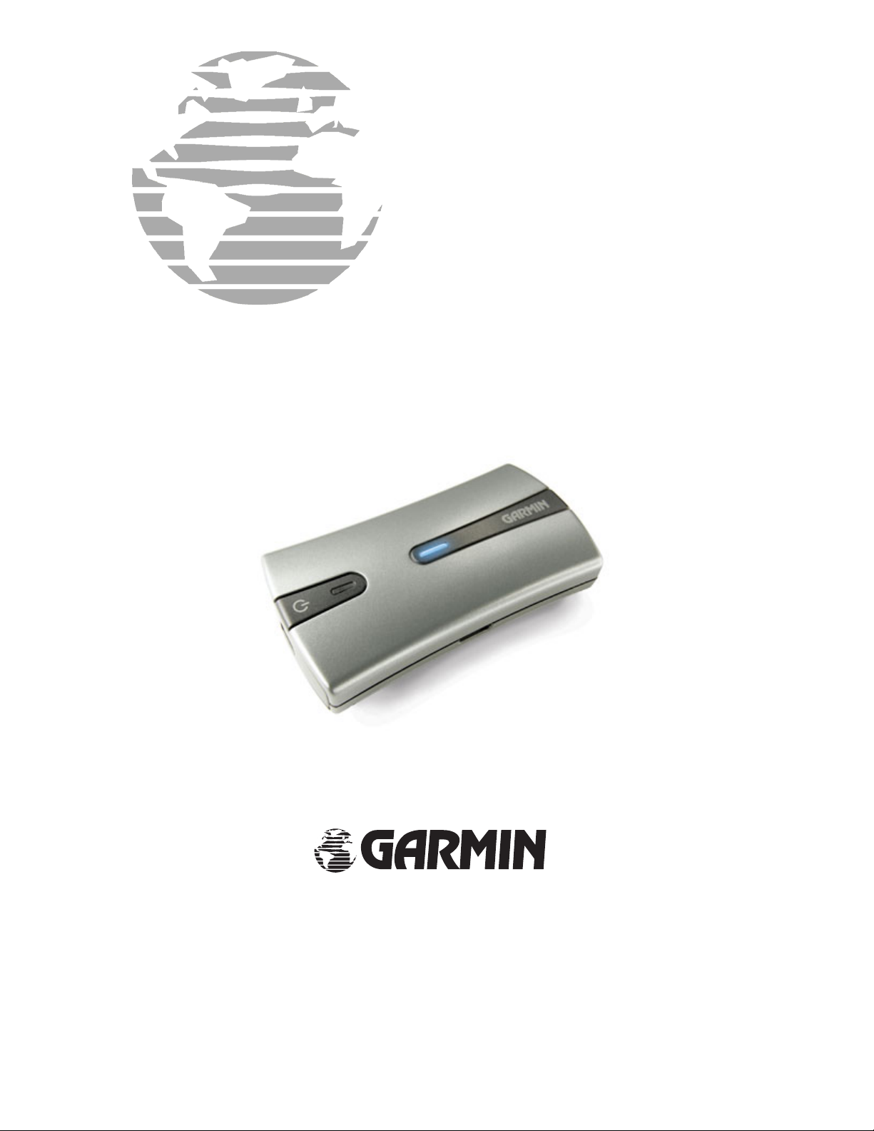
GPS 10x
TECHNICAL
SPECIFICATIONS
®
Garmin International, Inc.
1200 E. 151
Olathe, KS 66062 USA
190-00769-00, Revision A
December 2006
st
Street
Page 2

© Copyright 2006 Garmin Ltd. or its subsidiaries
Garmin International, Inc.
1200 East 151
st
Street, Olathe, Kansas 66062, U.S.A.
Tel. 913/397.8200 or 800/800.1020
Fax 913/397.8282
Garmin (Europe) Ltd.
Unit 5, The Quadrangle, Abbey Park Industrial Estate, Romsey, SO51 9DL, U.K.
Tel. 44/0870.8501241 (outside the UK) 0808 2380000 (inside the UK)
Fax 44/0870.8501251
Garmin Corporation
No. 68, Jangshu 2
nd
Road, Shijr, Taipei County, Taiwan
Tel. 886/2.2642.9199
Fax 886/2.2642.9099
All rights reserved. Except as expressly provided herein, no part of this manual may be reproduced, copied,
transmitted, disseminated, downloaded, or stored in any storage medium, for any purpose without the
express prior written consent of Garmin. Garmin hereby grants permission to download a single copy of
this manual onto a hard drive or other electronic storage medium to be viewed and to print one copy of this
manual or of any revision hereto, provided that such electronic or printed copy of this manual must contain
the complete text of this copyright notice and provided further that any unauthorized commercial
distribution of this manual or any revision hereto is strictly prohibited.
Information in this document is subject to change without notice. Garmin reserves the right to change or
improve its products and to make changes in the content without oblig ation to notify any person or
organization of such changes or improvements. Visit the Garmin Web site (
www.garmin.com) for current
updates and supplemental information concerning the use and operation of this and other Garmin products.
Garmin® and AutoLocate® are registered trademarks of Garmin Ltd. or its subsidiaries and may not be
used without express permissi on o f Garmin.
SiRF, SiRFstar and the Sirf logo are registered trademarks of SiRF Technology, Inc. SiRFstarIII and SiRF
Powered are trademarks of SiRF Technology, Inc. The Bluetooth® word mark and logos are owned by the
Bluetooth SIG, Inc. and any use of such marks by Garmin is under license.
Web site address:
www.garmin.com
RECORD OF REVISIONS
Revision Revision
Description ECO #
Date
A 12/6/06 Initial Release --
190-00769-00 GPS 10x Technical Specifications Rev. A
Page ii
Page 3

TABLE OF CONTENTS
1 Introduction..................................................................................................................1
1.1 Cautions ............................................................................................................................................1
1.2 Limited Warranty..............................................................................................................................2
1.3 Overview...........................................................................................................................................3
1.4 Features.............................................................................................................................................3
1.4.1 GPS 10x Wireless Receiver.................................................................................................................... 4
1.5 Technical Specifications ...................................................................................................................4
1.5.1 Physical Characteristics.......................................................................................................................... 4
1.5.1.1 Size............................................................................................................................................... 4
1.5.1.2 Weight.......................................................................................................................................... 4
1.5.1.3 Color............................................................................................................................................. 4
1.5.2 Electrical Characteristics........................................................................................................................ 5
1.5.2.1 Input Voltage ................................................................................................................................ 5
1.5.2.2 Input Current ................................................................................................................................ 5
1.5.2.3 Battery.......................................................................................................................................... 5
1.5.2.4 Battery Charger ............................................................................................................................ 5
1.5.3 Environmental Characteristics................................................................................................................ 5
1.5.3.1 Operating Temperature Range...................................................................................................... 5
1.5.3.2 Battery Charging Temperature Range.......................................................................................... 5
1.5.3.3 Storage Temperature..................................................................................................................... 5
1.5.4 GPS Performance ................................................................................................................................... 5
1.5.4.1 Receiver........................................................................................................................................ 5
1.5.4.2 Acquisition Times ........................................................................................................................ 5
1.5.4.3 Update Rate.................................................................................................................................. 5
1.5.4.4 Accuracy....................................................................................................................................... 5
1.5.5 Interfaces................................................................................................................................................ 6
1.5.5.1 GPS 10x Electrical Characteristics............................................................................................... 6
1.5.5.2 Garmin Interface........................................................................................................................... 6
1.5.5.3 GPS 10x Protocol ......................................................................................................................... 6
2 Mechanical Characteristics & Mounting...................................................................7
3 GPS 10 Software Interface..........................................................................................8
3.1 Received NMEA 0183 Sentences .....................................................................................................8
3.1.1 Additional Sensor Configuration Information (PGRMC1)..................................................................... 8
3.1.2 Output Sentence Enable/Disable (PG R MO)........................................................................................... 9
3.2 Transmitted NMEA 0183 Sentences.................................................................................................9
3.2.1 Sentence Transmission Rate................................................................................................................... 9
3.2.2 Transmitted Time..................................................................................................................................10
3.2.3 Global Positioning System Fix Data (GGA)..........................................................................................10
3.2.4 Recommended Minium Specific GPS/TRANSIT Data (RMC).............................................................11
3.2.5 Track Made Good and Ground Speed (VTG)........................................................................................11
3.2.6 Geographic Position (GLL)...................................................................................................................11
3.2.7 GPS DOP and Active Satellites (GSA) .................................................................................................11
3.2.8 GPS Satellites in View (GSV)...............................................................................................................12
3.2.9 Sensor Status Information (PGRMT) ....................................................................................................12
190-00769-00 GPS 10x Technical Specifications Rev. A
Page iii
Page 4

Appendix A: Binary Phase Output Format ..................................................................13
Appendix B: GPS 10x and Windows Serial Mouse Issue.............................................17
Appendix C: Sensor Configuration Software ...............................................................19
Downloading the Sensor Configuration Software............................................................................................19
Selecting a Model.............................................................................................................................................19
Connecting to the Sensor .................................................................................................................................19
File Menu.........................................................................................................................................................20
Comm Menu....................................................................................................................................................20
Config Menu....................................................................................................................................................20
View Menu.......................................................................................................................................................20
Help Menu .......................................................................................................................................................20
Appendix D: Host System Considerations.....................................................................21
PIN Code..........................................................................................................................................................21
LIST OF TABLES AND FIGURES
Figure 1. GPS 10x Operational Characteristics.............................................................................................. 7
Table 1: NMEA 0183 Output Sentence Order and Size................................................................................. 9
190-00769-00 GPS 10x Technical Specifications Rev. A
Page iv
Page 5

1 INTRODUCTION
1.1 CAUTIONS
CAUTION
The GPS system is operated by the government of the United States, which is solely responsible for its
accuracy and maintenance. Although the GPS 10x is a precision electronic NAVigation AID (NAVAID),
any NAVAID can be misused or misinterpreted, and therefore become un safe. Use these products at your
own risk. To reduce the risk, carefully review and understand all aspects of these Technical Specifications
before using the GPS 10x. When in actual use, carefully compare indications from the GPS to all available
navigation sources including the information from other NAVAIDs, visual sightings, charts, etc. For safety,
always resolve any discrepancies before continuing navigation.
FCC
Compliance
The GPS 10x complies with Part 15 of the FCC interference limits for Class B digital devices FOR HOME
OR OFFICE USE. These limits are designed to provide reasonable protection against harmful interference
in a residential installation, and are more stringent than “outdoor” requirements.
Operation of this device is subject to the following conditions: (1) This device may not cause harmful
interference, and (2) this device must accept any interference received, including interference that may
cause undesired operation.
This equipment generates, uses and can radiate radio frequency energy and, if not installed and used in
accordance with the instructions, may cause harmful interference to radi o communications. However, there
is no guarantee that interference will not occur in a particular installation. If this equipment does cause
harmful interference to radio or televisio n recept i on , whi ch can be determined by turning the equipment of f
and on, the user is encouraged to try to correct the interference by one or more of the following measures:
• Reorient or relocate the receiving antenna.
• Increase the separation between the equipment and receiver.
• Connect the equipment into an outlet on a circuit different from that to which the receiver is
connected.
• Consult the dealer or an experienced radio/TV technician for help.
The GPS 10x does not contain any user-serviceable parts. Unauthorized repairs or modifications could
result in permanent damage to the equipment, and void your warranty and your authority to operate this
device under Part 15 regulations.
Battery Warnings
If these guidelines are not followed, the lithium-ion battery may experience a shortened life span or may
present a risk of damage to the GPS unit, fire, chemical burn, electrolyte leak, and or injury. Contact your
local waste department to properly dispose of the unit/battery.
• Do not leave the unit exposed to a heat source or in a high temperature location, such as in the sun
in an unattended vehicle on a hot day. To prevent damage, remove the unit from the vehicle or
store it out of direct sunlight, such as in the glove box.
• Do not incinerate.
• When storing the unit for a limited length of time, store within the following temperature range: -
4˚ to 140˚F (-20˚ to 60˚C). When storing the unit for an extended time, store within the following
temperature range: 32˚ to 77˚F (0˚ to 25˚C).
• Do not operate the unit outside of the following temperature range:
14˚ to 140˚F (-10˚ to 60˚C).
• Keep the used battery away from children. Do not disassemble , pu nct ure, or damage the battery.
190-00769-00 GPS 10x Technical Specifications Rev. A
Page 1
Page 6

1.2 LIMITED WARRANTY
This Garmin product is warranted to be free from defects in materials or workmanship for one year from
the date of purchase. Within this period, Garmin will at its sole option repair or replace any components
that fail in normal use. Such repairs or replacement will be made at no charge to the customer for parts or
labor, provided that the customer shall be responsible for any transportation cost. This warranty does not
cover failures due to abuse, misuse, accident, or unauthorized alteration or repairs.
THE WARRANTIES AND REMEDIES CONTAINED HEREIN ARE E XCLUSIVE AND IN LIEU OF
ALL OTHER WARRANTIES EXPRESS OR IMPLIED OR STATUTORY, INCLUDING ANY
LIABILITY ARISING UNDER ANY WARRANTY OF MERCHANTABILITY OR FITNESS FOR A
PARTICULAR PURPOSE, STATUTORY OR OTHERWISE. TH IS WARRANTY GIVES YOU
SPECIFIC LEGAL RIGHTS, WHICH MAY VARY FROM STATE TO STATE.
IN NO EVENT SHALL GARMIN BE LIABLE FOR ANY INCIDENTAL, SPECIAL, INDIRECT OR
CONSEQUENTIAL DAMAGES, WHETHER RESULTING FROM THE USE, MISUSE, OR
INABILITY TO USE THIS PRODUCT OR FROM DEFECTS IN THE PRODUCT. Some states do not
allow the exclusion of incidental or consequential damages, so the above limitations may not apply to you.
Garmin retains the exclusive right to repair or replace the unit or software or offer a full refund of the
purchase price at its sole discretion. SUCH REMEDY SHALL BE YOUR SOLE AND EXCLUSIVE
REMEDY FOR ANY BREACH OF WARRANTY.
To obtain warranty service, contact your local Garmin authorized dealer or call Garmin Product Support at
one of the numbers listed below for shipping instructions and an RMA tracking number. The unit should be
securely packed with the tracking number clearly written on the
then be sent, freight charges prepaid, to any Garmin warranty service station. A copy of the original sales
receipt is required as the proof of purchase for warranty repairs.
outside of the package. The unit should
Garmin International, Inc.
1200 E 151st Street, Olathe, Kansas 66062 U.S.A.
Tel. 913/397.8200 or 800/800.1020
Fax. 913/397.8282
Garmin (Europe) Ltd.
Unit 5, The Quadrangle, Abbey Park Industrial Estate, Romsey, SO51 9DL U.K.
Tel. 44/0870.8501241 (outside the UK) 0808 2380000 (inside the UK)
Fax 44/0870.8501251
Online Auction Purchases: Products sold through online auctions are not eligible for rebates or other
special offers from Garmin. Online auction confirmations are not accepted for warranty verification. To
obtain warranty service, an original or copy of the sales receipt from the original retailer is required.
Garmin will not replace missing components from any package purchased through an online auction.
International Purchases: A separate warranty is provided by international distributors for units purchased
outside the United States. This warranty is provided by the local in-country distributor and this distributor
provides local service for your unit. Distributor warranties are only valid in the area of intended
distribution. Units purchased in the United States or Canada must be returned to the Garmin service center
in the United Kingdom, the United States, Canada, or Taiwan for service.
190-00769-00 GPS 10x Technical Specifications Rev. A
Page 2
Page 7

1.3 OVERVIEW
The GPS 10x product is a high sensitivity SiRFstarIIITM GPS receiver with WAAS capability, a removable
rechargeable lithium-ion battery, and Bluetooth® wireless technology capability. The GPS 10x tracks up to
12 satellites at a time while providing fast time-to-first-fix, one-second navigation updates, and low power
consumption. This generation of GPS sensors adds the capability of FAA Wide Area Augmentation System
(WAAS) differential GPS. The GPS 10x’s far-reaching capability meets the sensitivity requirements of
land navigation as well as the dynamics requirements of high-performance aircraft.
The GPS 10x design uses the latest technology and high-level circuit integration to achieve superior
performance while minimizing space and power requirements. All critical components of the system
including the GPS RF/IF receiver hardware and the GPS digital baseband are designed and manufactured
by Garmin to ensure the quality and capability of the GPS. The hardware capability combined with
software intelligence makes the GPS 10x easy to integrate and use for laptop/tablet PC, PDA, and smart
phone applications by incorporating a Class 2 Bluetooth module within the unit.
The GPS 10x product is designed to withstand rugged operating conditions. This complete GPS receiver
requires no additional components to be supplied by an OEM or system integrator. A removable
rechargeable lithium-ion battery and 1 2 VDC charging adapter are provided with the receiver. The only
requirement is a clear view of the GPS satellites. Internal FLASH memory allows the GPS to retain critical
data such as satellite orbital parameters, last-known position, date and time. End user interfaces such as
keyboards and displays are the responsibility of the application designer.
1.4 FEATURES
• Integrated Bluetooth® (Class 2) wireless technology module for communication with a mobile
device.
TM
• High sensitivity SiRFstarIII
and low power consumption.
GPS receiver uses up to 12 satellites for fast, accurate positioning
• Differential DGPS capability using real-time WAAS corrections yielding position errors of less
than 3 meters.
• Compact, rugged design ideal for applications with minimal space. Receiver position information
can be displayed directly on a chartplotter or laptop/tablet PC, PDA, or smart phone with
Bluetooth wireless technology capability.
• User initialization is not required. Once installed, unit automatically produces navigation data after
position fix is acquired.
• User-configurable navigation mode (2-dimensional or 3-dimensional fix).
• Configurable for binary format carrier phase data output.
• FLASH-based program and non-volatile memory. New software revisions available through Web
site download. Non-volatile memory does not require battery backup.
• Removable rechargeable main power battery.
• The real-time clock can run for up to 2 months after the battery enters a low battery mode.
• Configurable parameters include e xpected position, current time and date, preferred position fix
type (2D, 3D, or automatic), and velocity filter time constant (none, automatic, or your choice
between 2 and 255 seconds).
• Four anti-skid mounts for flat surface placement.
• Includes 12 VDC Cigarette Lighter Charging Adapter.
• Auto Power On Mode: When in the Off mode and connected to a switched 12 V DC external
power source, the GPS 10x automatically turns On when external power is turned on. (example: a
cigarette lighter controlled by the vehicle ignition switch.)
190-00769-00 GPS 10x Technical Specifications Rev. A
Page 3
Page 8
1.4.1 GPS 10x Wireless Receiver
The GPS 10x uses Bluetooth® wireless technology to interface with a mobile device (Computer/PDA) that
is Bluetooth wireless technology enabled.
Class 2 Bluetooth device with power control capability based on the Bluetooth System Specification,
Version 1.1. The supported profile is Serial Profile (SSP).
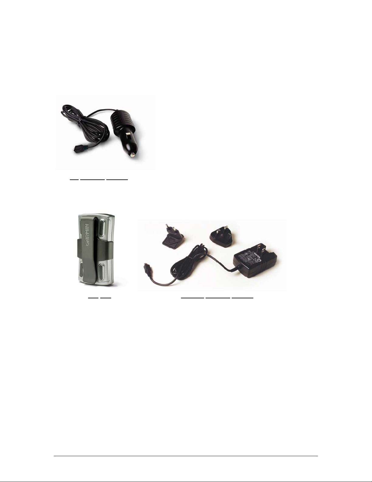
Accessories provided with the GPS 10x:
• 12 VDC Cigarette Lighter Charging Adapter with Mini B-USB Connector (010-10563-00)
DC
Charging Adapter
• Belt Clip (145-00956-70)
• Optional 110-115 V AC Charging Adapter with Mini B-USB connector (010-10723-00)
Belt
Clip Optional Charging Adapter
1.5 TECHNICAL SPECIFICATIONS
Specifications are subject to change without notice.
1.5.1 Physical Characteristics
1.5.1.1 Size
42 mm wide, 77 mm long and 18 mm in height (.697” H x 1.65”W x 3.04”D)
1.5.1.2 Weight
2.1 ounces (60 grams)
1.5.1.3 Color
Matt Metallic Silver with Black accents
1.5.1.4 Case Material
Polycarbonate thermoplastic and ABS case
190-00769-00 GPS 10x Technical Specifications Rev. A
Page 4
Page 9

1.5.2 Electrical Characteristics
1.5.2.1 Input Voltage
4.5–5.5 V
1.5.2.2 Input Current
500mA @ 5.0 V
1.5.2.3 Battery
• Capacity: 1100 mAHr
• Charging rate: Approx. 4 Hrs
• Operating time: Approx. 22 Hours with WAAS enabled.
1.5.2.4 Battery Charger
The included Cigarette Lighter Adapter (010-10563-00) can be used to charge the GPS 10x’s
internal battery
1.5.3 Environmental Characteristics
1.5.3.1 Operating Temperature Range
• -30°C to + 60°C Powered from external supply
• -10°C to +60°C Powered by removable rechargeable battery
1.5.3.2 Battery Charging Temperature Range
5°C to 45°C
• Input 10 to 30 V AC
• Output 4.9 to 5.25 V DC @ 1.0 A
1.5.3.3 Storage Temperature
-30°C to 60°C
1.5.4 GPS Performance
1.5.4.1 Receiver
High sensitivity SiRFstarIII
1.5.4.2 Acquisition Times
(On average for a stationary receiver with a clear view of the sky.)
• Warm: <1 sec
• Cold: <38 sec
• Factory Reset: <45 sec
1.5.4.3 Update Rate
1 record per second, continuous
1.5.4.4 Accuracy
• GPS accuracy
Position: <10 meters, typical
Velocity: 0.05 meters/sec RMS
• GPS (WAAS) accuracy
Position: <5 meters, typical
Velocity: 0.05 meters/sec RMS
TM
GPS receiver; WAAS-enabled.
190-00769-00 GPS 10x Technical Specifications Rev. A
Page 5
Page 10

1.5.5 Interfaces
1.5.5.1 GPS 10x Electrical Characteristics
• Communicate with Host Platform via Bluetooth Serial Profile
• Typical Range: up to 32 feet (10 meters)
1.5.5.2 Garmin Interface
Refer to the Garmin Device Interface Specification for specific information about the Garmin
Protocol. The document is located on the Garmin Web site at
commProtocol.html. See also Appendix A: Binary Phase Output Format for additional information
concerning access to raw pseudo-range and carrier phase data from the GPS 10x.
1.5.5.3 GPS 10x Protocol
• NMEA 0183 Version 2.0 or NMEA 0183 Version 2.30 (Version 2.0 is factory default,
programmable by data field 1 of the PGRMC1 sentence described in Section
Sensor Configuration Inform at i on (PGRMC1)
SiRF, refer to the SiRF website.
• Available NMEA 0183 output sentences include GPGGA, GPGSA, GPGSV, GPRM C, GP VTG ,
GPGLL, and PGRMT (Garmin proprietary sentences). See Section
Sentences
• Configuration and initialization is accomplished with NMEA 0183 input sentences. Allows
initialization of information such as expected position, date, time, earth datum, and differential
mode. See Section
• Configurable for binary data output incl u di n g GPS carri er phase data.
for format descriptions.
3.1 Received NMEA 0183 Sentences for format descriptions.
. To determine the specific sentences supported by
http://www.garmin.com/support/
3.1.1 Additional
3.2 Transmitted NMEA 0183
190-00769-00 GPS 10x Technical Specifications Rev. A
Page 6
Page 11
2 MECHANICAL CHARACTERISTICS & MOUNTING
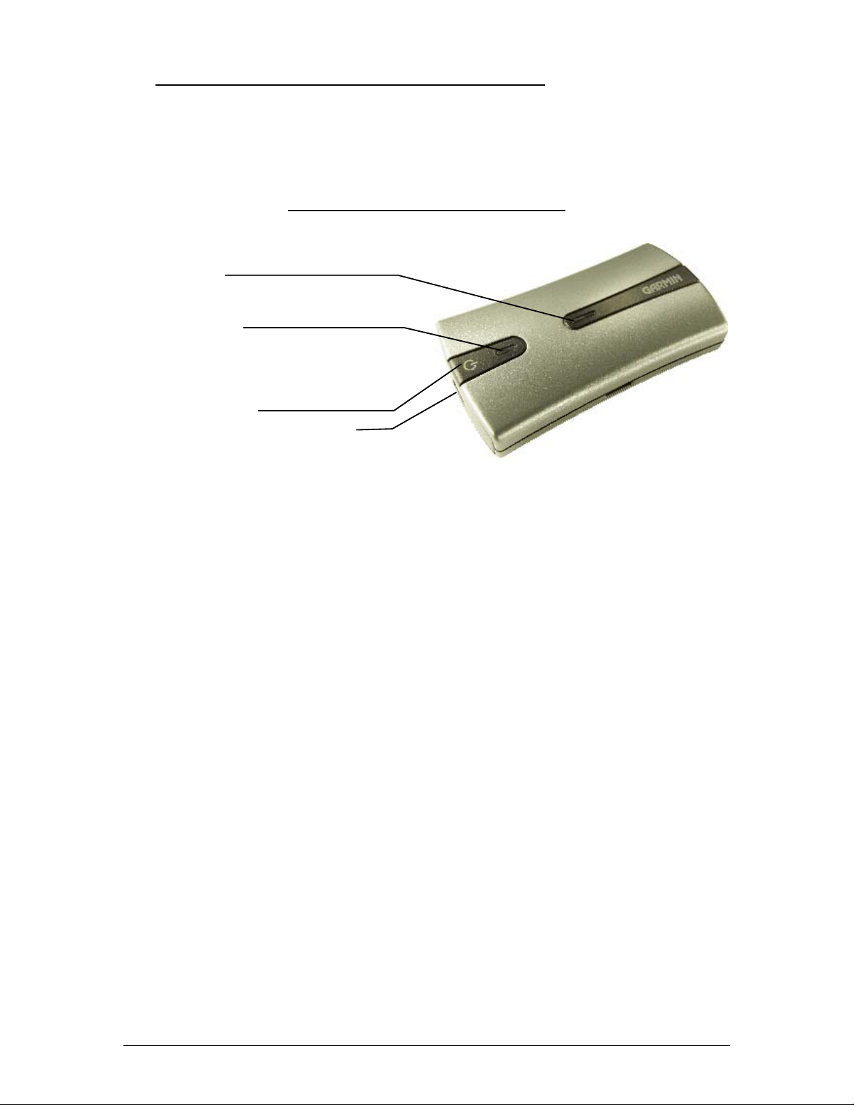
Figure 1 shows the operational characteristics of the GPS 10x. Figure 2 shows the auxiliary power plug
dimensions. Power Plug Specifications for charging the GPS 10x from user provided power source: MiniUSB connector (Range 4.5 to 5.5 VDC @ 500 mA)
Figure 1. GPS 10x Operational Characteristics
Bluetooth LED
Rapid Flashing Blue: Power On, Bluetooth On
Slow Flashing Blue: Bluetooth link established
Power Status LED
Flashing Yellow-Green: Charging in progress
Solid Yellow-Green: Battery charged
Flashing Orange: Low battery
Solid Orange: Faulty battery or system error
Power On.Off Button
Mini-USB Connector for Power Cable
190-00769-00 GPS 10x Technical Specifications Rev. A
Page 7
Page 12

3 GPS 10X SOFTWARE INTERFACE
The interface protocol design of the GPS 10x product is based on the National Marine Electronics
Association’s NMEA 0183 ASCII interface specification. This standard is fully defined in NMEA 0183,
Version 2.30. Copies may be obtained from NMEA,
In addition to the standard NMEA 0183 sentences, the GPS 10x may also be configured to transmit
information over their serial interface using NMEA 0183 compliant Garmin proprietary sentences. These
proprietary sentences begin with the characters, “$PGRM”, instead of the characters “$G” that are typical
of the standard NMEA 0183 sentences. The characters “$P” indicate that the sentence is a proprietary
implementation and the characters and “GRM” indicate that it is Garmin’s proprietary sentence. The letter
(or letters) that follow the characters “$PGRM” uniquely identifies that particular Garmin proprietary
sentence.
It is also possible to configure the GPS 10x to transmit binary phase data information over their serial
interface. See
The following sections describe the NMEA 0183 data format of each sentence transmitted and received by
the GPS 10x product.
Appendix A: Binary Phase Output Format for details.
http://www.nmea.org/.
3.1 RECEIVED NMEA 0183 SENTE NCES
The following paragraphs define the sentences that can be received on the GPS sensor’s port. Null fields in
the configuration sentence indicate no change in the particular configuration parameter. All sentences
received by the GPS sensor must be terminated with <CR><LF>, the ASCII characters for carriage return
(0D hexadecimal) and line feed (0A hexadecimal). The checksum *hh is used for parity checking data and
is not required, but is recommended for use in environments containing high electromagnetic noise. It is
generally not required in normal PC environments. When used, the parity bytes (hh) are the ASCII
representation of the exclusive-or (XOR) sum of all the characters between the “$” and “*” characters, noninclusive. The hex representation must be a capital letter, such as 3D instead of 3d. Sentences may be
truncated by <CR><LF> after any data field and valid fields up to that point will be acted on by the sensor.
3.1.1 Additional Sensor Configuration Information (PGRMC1)
The $PGRMC1 sentence provides additional information used to configure the GPS sensor operation.
Configuration parameters are stored in non-volatile memory and retained between power cycles. The GPS
sensor will echo this sentence upon its receipt if no errors are detected. If an error is detected, the echoed
PGRMC1 sentence will contain the current default values. Current default values can also be obtained by
sending $PGRMC1E to the GPS sensor.
$PGRMC1,<1>,<2>,<3>,<4>,<5>,<6>,<7>,<8>,<9>,<10>,<11>,<12>*hh<CR><LF>
<11> Auto Power Off, 1 = Off, 2 = On
<12> Power On with External Charger , 1 = Off, 2 = On
Configuration changes take effect immediately, with the exception of Binary Phase Output Data, which
takes effect on the next power cycle or a reset event. If the GPS sensor is in the Binary data mode, it is
necessary to send the following eight-byte data stream to temporarily change the data format to NMEA
0183. Then follow by sending a PGRMC1 sentence that turns off the Binary Phase Output Data format:
10 0A 02 26 00 CE 10 03 (Hexadecimal)
190-00769-00 GPS 10x Technical Specifications Rev. A
Page 8
Page 13
3.1.2 Output Sentence Enable/Disable (PGRMO)
The $PGRMO sentence provides the ability to enable and disable specific output sentences. The following
sentences are enabled at the factory: GPGGA, GPGSA, GPGSV, GPRMC, and PGRMT.
$PGRMO,<1>,<2>*hh<CR><LF>
<1> Target sentence description (e.g., PGRMT, GPGSV, etc.)
<2> Target sentence mode, wher e:
0 = disable specified sentence
1 = enable specified s entence
2 = disable all output sentences
3 = enable all output sentences (except GPALM)
4 = restore factory default output sentences
The following notes apply to the PGRMO input sentence:
1. If the target sentence mode is ‘2’ (disable all), ‘3’ (enable all), or ‘4’ (restore defaults), the target
sentence description is not checked for validity. In this case, an empty field is allowed (e.g.,
$PGRMO,,3), or the mode field may contain from 1 to 5 characters.
2. If the target sentence mode is ‘0’ (disable) or ‘1’ (enable), the target sentence description field must be
an identifier for one of the sentences that can be output by the GPS sensor.
3. If either the target sentence mode field or th e target sentence description field is not valid, the PGRMO
sentence will have no effect.
4. $PGRMO,,G will cause the COM port to change to Garmin Data Transfer format for the duration of
the power cycle. The Garmin mode is required for GPS 10 series product software updates.
3.2 TRANSMITTED NMEA 0183 SENTENCES
The subsequent paragraphs define the sentences that can be transmitted by the GPS 10x.
3.2.1 Sentence Transmission Rate
Sentences are transmitted with respect to the user selected baud rate.
The GPS sensor will transmit each sentence (except where noted in particular transmitted sentence
descriptions) at a periodic rate based on the user selected baud rate and user selected output sentences. The
GPS sensor will transmit the selected sentences contiguously. The length of the transmission can be
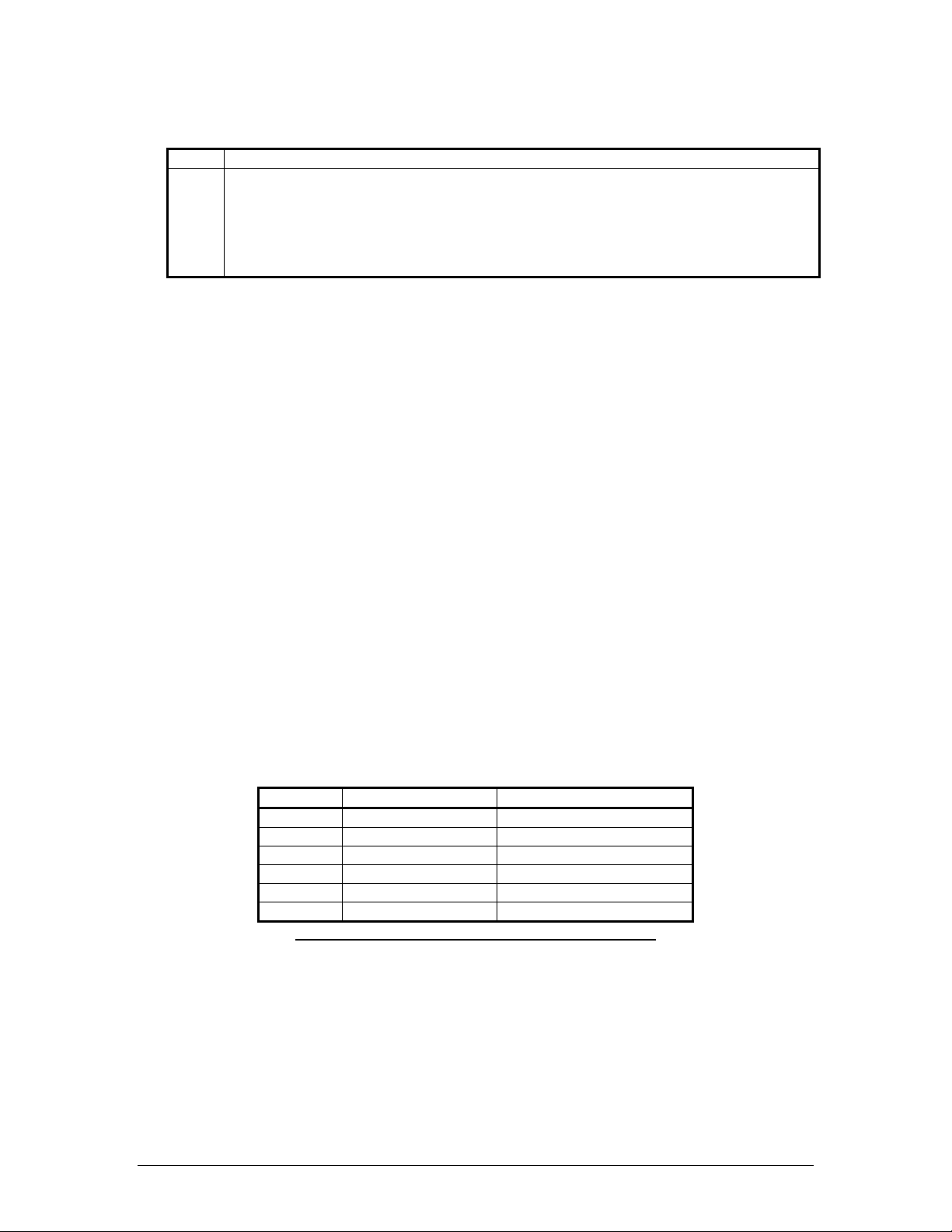
determined by the following equation and Tables 2 and 3:
total characters to be transmitted
length of transmission = -------------------------------------------- characters transmitted per second
Sentence Output by Default? Maximum Characters
GPGGA
GPGSA
GPGSV
GPGLL 44
GPVTG 42
PGRMT Once per minute 50
Table 1: NMEA 0183 Output Sentence Order and Size
The maximum number of fields allowed in a single sentence is 82 characters including delimiters. Values
in the table include the sentence start delimiter character “$” and the termination delimiter <CR><LF>. The
factory set defaults will result in a once per second transmission at the NMEA 0183 specification.
82
66
70
190-00769-00 GPS 10x Technical Specifications Rev. A
Page 9
Page 14

3.2.2 Transmitted Time
The GPS sensor outputs UTC (Coordinated Universal Time) date and time of day in the transmitted
sentences. Before the initial position fix, the on-board clock provides the date and time of day. After the
initial position fix, the date and time of day are calculated using GPS satellite information and are
synchronized with the one-pulse-per-second output.
The GPS sensor uses information obtained from the GPS satellites to add or delete UTC leap seconds and
correct the transmitted date and time of day. The transmitted date and time of day for leap second
correction follow the guidelines in National Institute of Standards and Tech nology Special Publication 432
(Revised 1990). This document is for sale by the Superintendent of Documents, U.S. Government Printing
Office, Washington, D.C., 20402, U.S.A.
When a positive leap second is required, one second is inserted at the beginning of the first hour (0h 0m 0s)
of the day that the positive leap is occurring. The minute containing the leap second is 61 seconds long. The
GPS sensor would have transmitted this information for the leap second added December 31, 1998 as
follows:
$GPRMC,235959,A,3851.3651,N,09447.9382,W,000.0,221.9,071103,003.3,E*69
$GPRMC,000000,A,3851.3651,N,09447.9382,W,000.0,221.9,081103,003.3,E*67
$GPRMC,000000,A,3851.3651,N,09447.9382,W,000.0,221.9,081103,003.3,E*67
$GPRMC,000001,A,3851.3651,N,09447.9382,W,000.0,221.9,081103,003.3,E*66
If a negative leap second should be required, one second will be deleted at the end of some UTC month.
The minute containing the leap second will be only 59 seconds long. In this case, the GPS sensor will not
transmit the time of day 0h 0m 0s (the “zero” second) for the day from which the leap second is removed.
$GPRMC,235959,A,3851.3650,N,09447.9373,W,000.0,000.0,111103,003.3,E*69
$GPRMC,000001,A,3851.3650,N,09447.9373,W,000.0,000.0,121103,003.3,E*6A
$GPRMC,000002,A,3851.3650,N,09447.9373,W,000.0,000.0,121103,003.3,E*69
3.2.3 Global Positioning System Fix Data (GGA)
$GPGGA,<1>,<2>,<3>,<4>,<5>,<6>,<7>,<8>,<9>,M,<10>,M,<11>,<12>*hh<CR><LF>
<1> UTC time of position fix, hhmmss format
<2> Latitude, ddmm.mmmm format (leading zeros will be transmitted)
<3> Latitude hemisphere, N or S
<4> Longitude, dddmm.mmmm format (leading zeros will be transmitted)
<5> Longitude hemisphere, E or W
<6> GPS quality indication, 0 = fix not available, 1 = Non-differential GPS fix available, 2 =
Differential GPS (DGPS) fix available, 6 = Estimated
<7> Number of satellites in use, 00 to 12 (leading zeros will be transmitted)
<8> Horizontal dilution of precision, 0.5 to 99.9
<9> Antenna height above/below mean sea level, -9999.9 to 99999.9 meters
<10> Geoidal height, -999.9 to 9999.9 meters
<11> Differential GPS (RTCM SC-104) data age, number of seconds since last valid RTCM
transmission (null if not an RTCM DGPS fix)
<12> Differential Reference Station ID, 0000 to 1023 (leading zeros will be transmitted, null if not an
RTCM DGPS fix)
190-00769-00 GPS 10x Technical Specifications Rev. A
Page 10
Page 15

3.2.4 Recommended Minimum Specific GPS/TRANSIT Data (RMC)
$GPRMC,<1>,<2>,<3>,<4>,<5>,<6>,<7>,<8>,<9>,<10>,<11>,<12>*hh<CR><LF>
<1> UTC time of position fix, hhmmss format
<2> Status, A = Valid position, V = NAV receiver warning
<3> Latitude, ddmm.mmmm format (leading zeros will be transmitted)
<4> Latitude hemisphere, N or S
<5> Longitude, dddmm.mmmm format (leading zeros will be transmitted)
<6> Longitude hemisphere, E or W
<7> Speed over ground, 000.0 to 999.9 knots (leading zeros will be transmitted)
<8> Course over ground, 000.0 to 359.9 degrees, true (leading zeros will be transmitted)
<9> UTC date of position fix, ddmmyy format
<10> Magnetic variation, 000.0 to 100.0 degrees (leading zeros will be transmitted)
<11> Magnetic variat i on di recti o n, E or W (westerly variation adds to true course)
<12> Mode indicator (only output if NMEA 0183 version 2.30 active), A = Autonomous,
D = Differential, E = Estimated, N = Data not valid
3.2.5 Track Made Good and Ground Speed (VTG)
$GPVTG,<1>,T,<2>,M,<3>,N,<4>,K,<5>*hh<CR><LF>
<1> True course over ground, 000 to 359 degrees (leading zeros will be transmitted)
<2> Magnetic course over ground, 000 to 359 degrees (leading zeros will be transmitted)
<3> Speed over ground, 000.0 to 999.9 knots (leading zeros will be transmitted)
<4> Speed over ground, 0000.0 to 1051.8 kilometers per hour (leading zeros will be transmitted)
<5> Mode indicator (only output if NMEA 0183 version 2.30 active), A = Autonomous,
D = Differential, E = Estimated, N = Data not valid
3.2.6 Geographic Position (GLL)
$GPGLL,<1>,<2>,<3>,<4>,<5>,<6>,<7>*hh<CR><LF>
<1> Latitude, ddmm.mmmm format (leading zeros will be transmitted)
<2> Latitude hemisphere, N or S
<3> Longitude, dddmm.mmmm format (leading zeros will be transmitted)
<4> Longitude hemisphere, E or W
<5> UTC time of position fix, hhmmss format
<6> Status, A = Valid position, V = NAV receiver warning
<7> Mode indicator (only output if NMEA 0183 version 2.30 active), A = Autonomous,
D = Differential, E = Estimated, N = Data not valid
3.2.7 GPS DOP and Active Satellites (GSA)
$GPGSA,<1>,<2>,<3>,<3>,<3>,<3>,<3>,<3>,<3>,<3>,<3>,<3>,<3>,<3>,<4>,<5>,<6>*hh<CR><LF>
<1> Mode, M = manual, A = automatic
<2> Fix type, 1 = not available, 2 = 2D, 3 = 3D
<3> PRN number, 01 to 32, of satellite used in solution, up to 12 transmitted (leading zeros will be
transmitted)
<4> Position dilution of precision, 0.5 to 99.9
<5> Horizontal dilution of precision, 0.5 to 99.9
<6> Vertical dilution of precision, 0.5 to 99.9
190-00769-00 GPS 10x Technical Specifications Rev. A
Page 11
Page 16
3.2.8
GPS Satellites in View (GSV)
$GPGSV,<1>,<2>,<3>,<4>,<5>,<6>,<7>,...<4>,<5>,<6>,<7>*hh<CR><LF>
<1> Total number of GSV sentences to be transmitted
<2> Number of current GSV sentence
<3> Total number of satellites in view, 00 to 12 (leading zeros will be transmitted)
<4> Satellite PRN number, 01 to 32 (leading zeros will be transmitted)
<5> Satellite elevation, 00 to 90 degrees (leading zeros will be transmitted)
<6> Satellite azimuth, 000 to 359 degrees, true (leading zeros will be transmitted)
<7> Signal to noise ratio (C/No) 00 to 99 dB, null when not tracking (leading zeros will be
transmitted)
NOTE: Items <4>,<5>,<6>, and <7> repeat for each satellite in view to a maximum of four (4) satellites
per sentence. Additional satellites in view information must be sent in subsequent bursts of NMEA 0183
data. These fields will be null if unused.
3.2.9 Sensor Status Information (PGRMT)
The Garmin Proprietary sentence $PGRMT gives information concerning the status of the GPS sensor.
This sentence is transmitted once per minute regardless of the selected baud rate.
$PGRMT,<1>, , , , , , , ,
<1> Product, model and software version (variable length field, e.g., “GPS 10 SW VER 2.01 BT
VER 1.27 764”)
190-00769-00 GPS 10x Technical Specifications Rev. A
Page 12
Page 17

APPENDIX A: BINARY PHASE OUTPUT FORMAT
In binary phase output mode, GPS 10x series products will transmit two types of packets once per second.
One record contains primarily post-process information such as position and velocity information. The
second record contains receiver measurement information.
Refer to the Garmin Device Interface Specification for details on how to form and parse Garmin packets.
At the time of this printing, these specs are available from the technical suppport section of our Web site at
http://www.garmin.com/support/commProtocol.html.
For the GPS 10, the two records must be enabled independently by commands to the unit. The ID of each
command should be 10 decimal to signify that the record is a command. The data portion of the packet
should be one of the following:
Function Command (base 10)
Position Record On 49
Position Record Off 50
Receiver Measurement Record On 110
Receiver Measurement Record Off 111
Note that the satellite data information is also enabled when the position record is enabled.
Records sent over RS232 begin with a delimiter byte (10 hex). The second byte identifies the record type
(33 hex for a position record and 72 hex for a satellite data record). The third byte indicates the size of the
data. The fourth byte is the first byte of data. The data is then followed by a checksum byte, a delimiter
byte (10 hex), and an end-of-transmission character (03 hex). Additionally, any DLEs (0x10) that appear
between the delimeters are escaped with a second DLE. There is sample code at the end of this section that
will strip off the DLEs and ETXs.
RS232 Packet:
- 0x10 (DLE is first byte)
- 0x## (Record ID – single byte)
- 0x## (Number of data bytes – single byte)
- data bytes (See descriptions below)
- 0x## (2’s complement of the arithmetic sum of the bytes between the delimiters)
- 0x10 (DLE)
- 0x03 (ETX is last byte)
USB packets contain only the record ID, size, and data payload. Refer to the Garmin Device Interface
Specification for details on how to form and parse Garmin USB packets. The document is located on the
Garmin Web site at
USB Packet:
- 0x## (Record ID – single byte)
- 0x## (Number of data bytes – single byte)
- data bytes (See descriptions below)
The data bytes of each packet contain the record specified by the record ID. A description of each record
follows.
http://www.garmin.com/support/ commProtocol.html.
190-00769-00 GPS 10x Technical Specifications Rev. A
Page 13
Page 18

Satellite Data Record
The satellite data has a record ID of 0x72 with 84 (0x54) data bytes. The data bytes contain the data for the
12 channels as described below. For each satellite, the following data is available:
typedef struct
{
uint8 svid; //space vehicle identification (1-32 and 33-64 for WAAS)
uint16 snr; //signal-to-noise ratio
uint8 elev; //satellite elevation in degrees
uint16 azmth; //satellite azimuth in degrees
uint8 status; //status bit-field
} cpo_sat_data;
The status bit field represents a set of booleans described below:
Bit Meaning when bit is one (1)
0 The unit has ephemeris data for the specified satellite.
1 The unit has a differential correction for the specified satellite.
2 The unit is using this satellite in the solution.
This pattern is repeated for all 12 channels for a total of 12 X 7 bytes = 84 (0x54) bytes :
typedef struct
{
cpo_sat_data
cpo_sat_data
cpo_sat_data
cpo_sat_data
cpo_sat_data
cpo_sat_data
cpo_sat_data
cpo_sat_data
cpo_sat_data
cpo_sat_data
cpo_sat_data
cpo_sat_data
} cpo_all_sat_data
The RS-232 Packet for the Satellite Record looks like:
- 0x10 (DLE is first byte)
- 0x72 (Record ID – single byte)
- 0x54 (Number of data bytes – single byte)
- cpo_all_sat_data
- 0x## (2’s complement of the arithmetic sum of the bytes between the delimiters)
- 0x10 (DLE)
- 0x03 (ETX is last byte)
The USB Packet for the Satellite Record looks like:
38 INDIAN - Thailand, Vietnam
- 0x72 (Record ID – single byte)
- 0x54 (Number of data bytes – single byte)
- cpo_all_sat_data
190-00769-00 GPS 10x Technical Specifications Rev. A
Page 14
Page 19

Position Record
The Position Record has a record identifier of
typedef struct
{
float alt;
float epe;
float eph;
Sample C code to receive the two records should filter DLE and ETX bytes as described below:
typedef enum
{
DAT,
DLE,
ETX
} rx_state_type;
/* Declare and initialize static variables */
static char in_que[ 256 ];
static int in_que_ptr = 0;
static rx_state_type rx_state = DAT;
.
.
.
float epv;
int fix;
double gps_tow;
double lat;
double lon;
float lon_vel;
float lat_vel;
float alt_vel;
float msl_hght;
int leap_sec;
long grmn_days;
} cpo_pvt_data;
alt Ellipsoid altitude (meters)
epe Est pos error (meters)
eph Pos err, horizontal (meters)
epv Pos err, vertical (meters)
fix 0 = no fix; 1 = no fix; 2 = 2D; 3 = 3D; 4 = 2D differential; 5 = 3D differential; 6 + = undefined
gps_tow GPS time of week (sec)
lat Latitude (radians)
lon Longitude (radians)
lon_vel Longitude velocity (meters/second)
lat_vel Latitude velocity (meters/second)
alt_vel Altitude velocity (meters/second)
msl_hght Mean sea level height (meters)
leap_sec UTC leap seconds
grmn_days Garmin days (days since December 31, 1989)
190-00769-00 GPS 10x Technical Specifications Rev. A
Page 15
Page 20

DLE and ETX bytes:
void add_to_que( char data )
{
#define DLE_BYTE 0x10
#define ETX_BYTE 0x03
if ( rx_state == DAT )
{
if ( data == DLE_BYTE )
{
rx_state = DLE;
}
else
{
in_que[ in_que_ptr++ ] = data;
}
}
else if ( rx_state == DLE )
{
if ( data == ETX_BYTE )
{
rx_state = ETX;
}
else
{
rx_state = DAT;
in_que[ in_que_ptr++ ] = data;
}
}
else if ( rx_state == ETX )
{
if ( data == DLE_BYTE )
{
rx_state = DLE;
}
}
if ( in_que_ptr > 255 )
{
in_que_ptr = 0;
}
}
190-00769-00 GPS 10x Technical Specifications Rev. A
Page 16
Page 21

APPENDIX B: GPS 10X AND WINDOWS SERIAL MOUSE ISSUE
Problem: It is possible for Windows to incorrectly interpret the NMEA 0183 output of the GPS 10x as the
output of a Microsoft Serial BallPoint Mouse. When that happens, Windows loads drivers for the Serial
BallPoint Mouse. This causes the cursor to move erratically about the display, clicking, right clicking,
double clicking, dragging and dropping displayed items as it goes. On W indows 2000 and Windows XP,
you may not experience the problem if you wait until after the computer is booted before connecting the
GPS 10x to the serial communications port. This problem is not specific to the GPS 10x. Any N MEA 0183
device connected to a Windows computer’s serial port is likely to cause this problem. Below are several
possible solutions to this problem.
Note: If you are using Garmin nRoute™ Navigation Software with your GPS 10x, you will not have this
problem because the unit is programmed to produce data according to the binary format that is described in
Appendix A: Binary Phase Output Format.
If you wish to use a different navigation software application with your GPS 10x, you will need to de-select
the “Phase Output Data” option that is discussed in Solution 3 below.
Solution 1: The easiest solution is to disable the Serial BallPoint mouse in the Device Manager. Of course,
this solution assumes that you do not need to use a Serial BallPoint mouse with your compu ter. When the
wild mouse problem occurs follow the steps below.
1. Unplug the DB9 connector.
2. Right-click on the My Computer icon on your desktop and select Properties to open the Device
Manager.
3. Go to the hardware tab of the resulting pop-up window and click on the Device Manager button.
4. Right-click on Serial BallPoint Mouse and choose the option to Disable (NOT uninstall) this device.
Solution 2: Do not plug the DB9 connector into the computer until the computer is turned on and the
operating system is completely booted up and running. Every time you use the GPS 10x, you will need to
start the computer and operating system before making the connection between the GPS 10x PC and the
computer. This solution usually works on Windows 2000 and Windows XP computers.
Solution 3: Change the default output of the GPS 10x so that it does not automatically send NMEA 0183
data to the computer (change the default configuration to enable “Phase Output Data”). Use the Garmin
Sensor Configuration Software, named SNSRCFG.EXE, provided on the Web site to enable “Phase Output
Data.” SNSRCFG.EXE is included with the latest GPS 10x firmware.
Please note that by enabling “Phase Output Data,” the device will no longer appear as a NMEA 0183
device to your computer. As a result, mapping applications that expect to hear NMEA 0183 data will not
recognize your GPS 10x until you re-enable the NMEA 0183 output, disabling the “Phase Output Data” in
the process.
Refer to
Appendix C: Sensor Configuration Software for complete information about downloading the Sensor
Configuration Software application.
After the Sensor Configuration Software is installed and running on your computer, follow the steps below
to change the default data output of the GPS 10x.
1. Select the GPS 10x from the list of sensors and click OK. The Sensor Configuration Software opens
with the default configuration file for the GPS 10x, as shown on the next
page.
2. Select Config > Switch to NMEA Mode (or press the F10 key).
3. Select Comm > Setup to open the Comm Setup Window.
190-00769-00 GPS 10x Technical Specifications Rev. A
Page 17
Page 22
4. Select the Serial Port to which the GPS 10x is connected. Select Auto to have the program
automatically determine the Baud Rate, or select Manual to manually select the Baud Rate of the GPS
10x. Click OK when done.
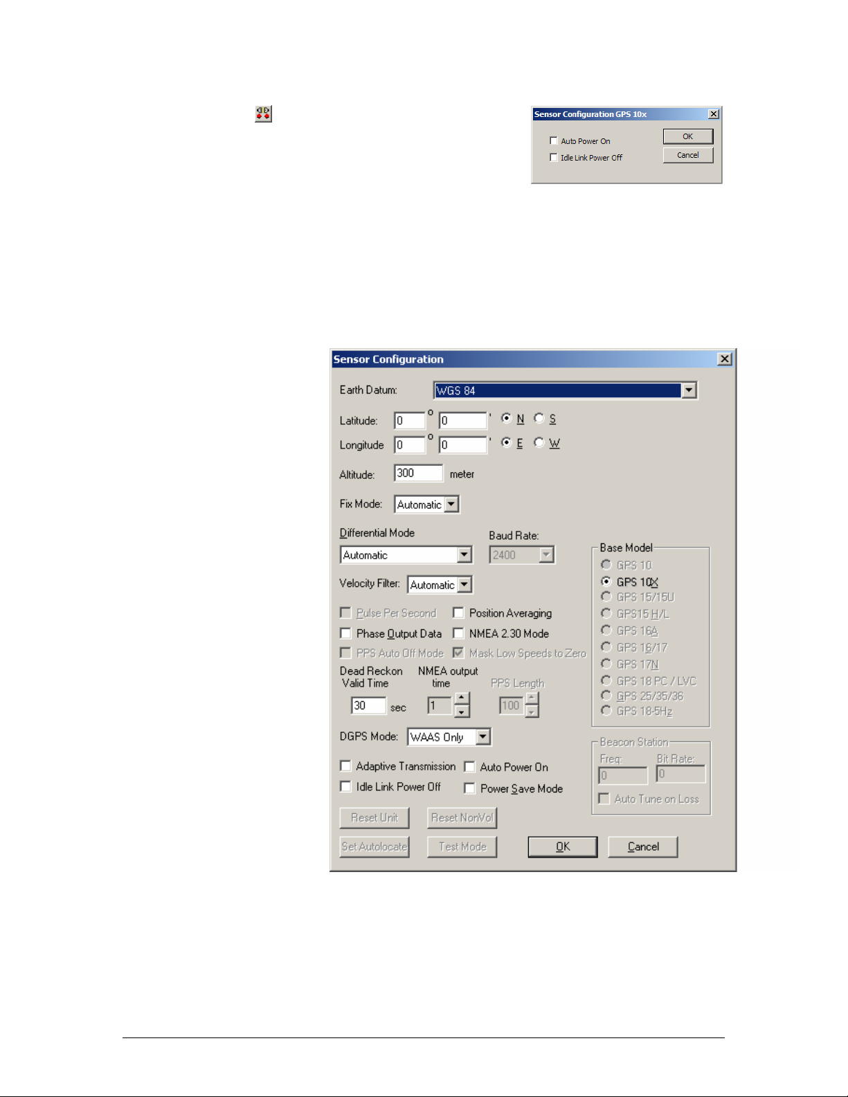
Click the Connect icon , or select Comm > Connect to connect to
the GPS 10x.
5. Place a check mark in the box next to “Binary Output Data” to
change the GPS 10x to Garmin Mode. The unit will keep this
change in the programming until you change it again in the
software.
Note: Selecting Config > Switch to Garmin Mode (or pressing the F11 key) only changes the unit to
work in Garmin Mode until power is cycled through the unit again. For a more permanent change,
refer to step 8 above.
6. Click OK when completed enabling “Binary Output Data.”
7. You may disconnect and close the software when finished. The software configuration can also be
saved for future reference.
Refer to
Appendix C: Sensor
Configuration Software for
complete information about
downloading the Sensor
Configuration Software
application.
190-00769-00 GPS 10x Technical Specifications Rev. A
Page 18
Page 23
APPENDIX C: SENSOR CONFIGURATION SOFTWARE
SNSRCFG configures the GPS sensors based on user-selected parameters. Some application features
include the ability to download GPS sensor configuration, maintain different configurations in files, and
perform GPS sensor configurations quickly with the use of one function key.
This section provides a brief overview of the Sensor Configuration Software. Refer to this section when
using the software to configure your Garmin sensor.
Downloading the Sensor Configuration Software
The Garmin Sensor Configuration Software (SNSRCFG.exe) is available
from the Garmin Web site. To download the software, start at
http://www.garmin.com/oem, select the GPS 10x, and then select Software
Updates. The Garmin Sensor Configuration Software (SNSRCFG.exe) is
included in the software update download.
Selecting a Model
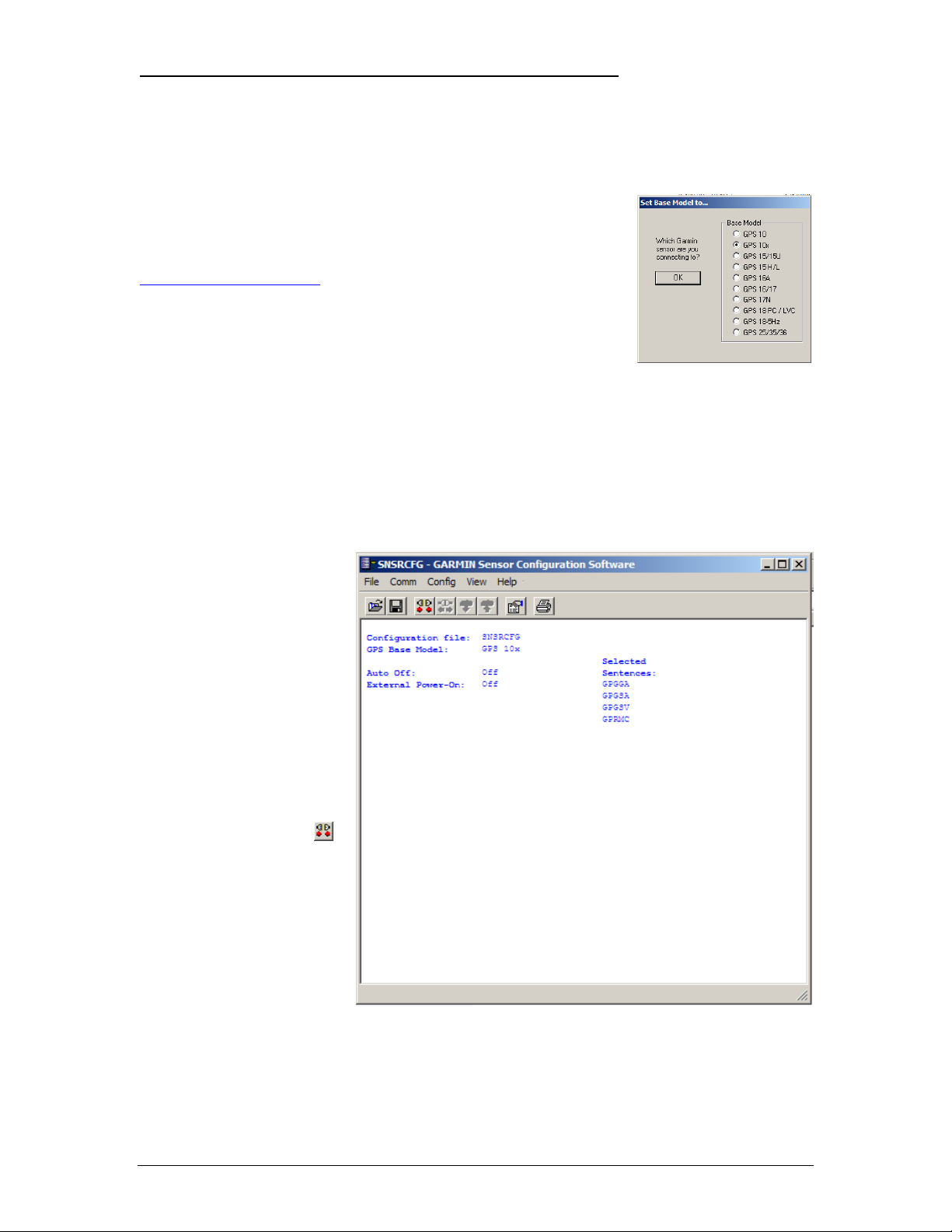
After opening the program (snsrcfg.exe), the following screen appears. Select the radio button next to the
type of Garmin sensor you are configuring.
Connecting to the Sensor
After selecting the type of sensor, the following window opens. This is the Main Interface Screen for the
program. To configure your sensor, you must fir st connect to the sensor.
1. Select Config > Switch to
NMEA Mode (or press the
F10 key).
2. Select Comm > Setup to
open the Comm Setup
Window.
3. Select the Serial Port to
which the sensor is
connected. Select Auto to
have the program
automatically determine the
Baud Rate, or select
Manual to manually select
the Baud Rate of the GPS
10x. Click OK when done.
4. Click the Connect icon
or select Comm >
Connect.
5. To view the current
programming of the sensor,
select Config > Get
Configuration from GPS
(or press the F8 key). The
current programming of the
sensor is displayed in the
window shown to the right.
,
190-00769-00 GPS 10x Technical Specifications Rev. A
Page 19
Page 24
File Menu
The File Menu allows you to open, save, and print sensor configurations. The items in the File Menu work
like most Windows-based programs.
Comm Menu
The Comm (Communication) Menu allows you to set the port numb er, baud rate, and then connect and
disconnect from the sensor.
Setup: Opens the Comm Setup Window, shown to the left. Select the Serial Port to which the sensor is
connected from the drop-down list. Then select Auto (the program determines the baud rate on its own) or
Manual (you then enter the baud rate) for the Baud Rate entry.
Connect: Select Connect to connect to the sensor to change or view the
configuration.
Disconnect: Select Disconnect to disconnect from the sensor.
Config Menu
The Config (Configuration) Menu allows you configure the sensor as it is
connected.
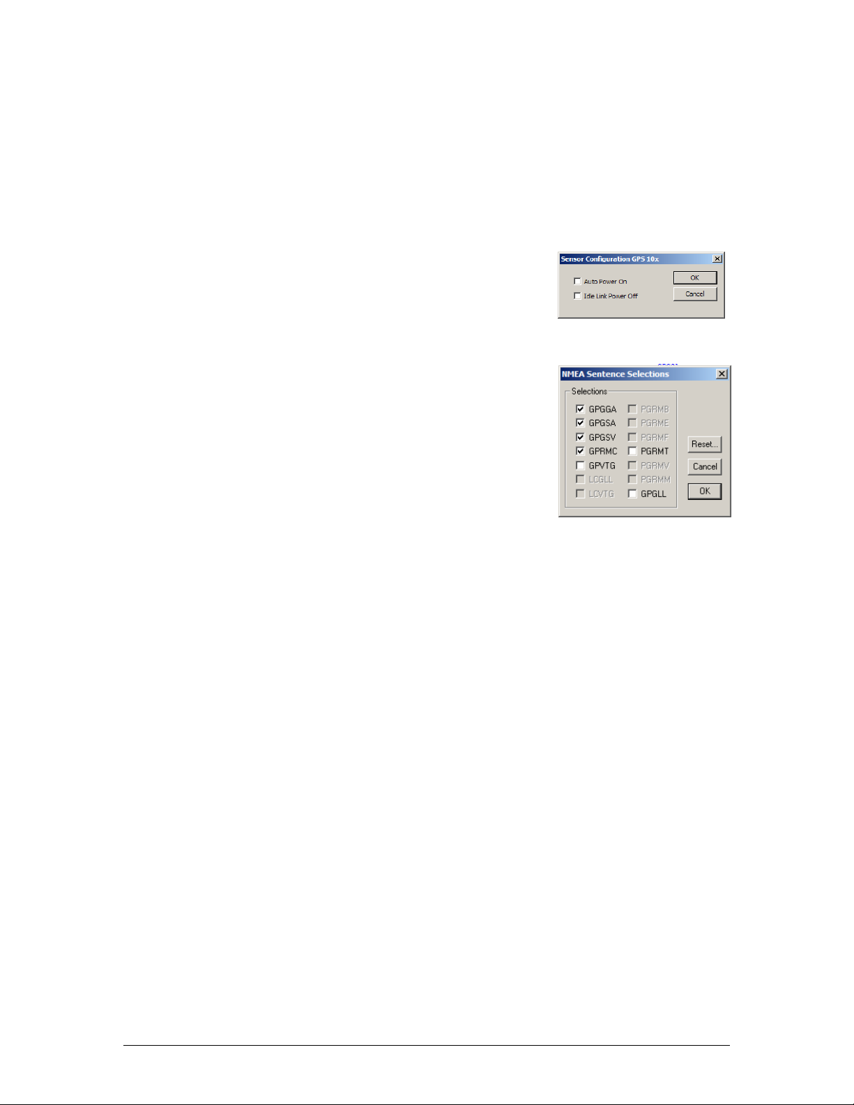
NMEA Sentence Selections (F7): Displays the NMEA Sentence S
elections Window. If the sentence is enabled, a check mark appears in the
box to the left of the sentence name. Click the box to enable or disable to
the sentence.
Switch to NMEA Mode (F10): Switche s the unit to NMEA Mode. The
sensor must be in NMEA Mode when connected to this software.
Switch to Garmin Mode (F11): Switches the unit to Garmin Mode.
View Menu
The View Menu allows you to view the NMEA sentences transmitted by the sensor. You can also
customize how the program looks by showing and hiding the Toolbar and Status Bar.
Help Menu
The Help Menu displays the software version and copyright information.
190-00769-00 GPS 10x Technical Specifications Rev. A
Page 20
Page 25
APPENDIX D: HOST SYSTEM CONSIDERATIONS:
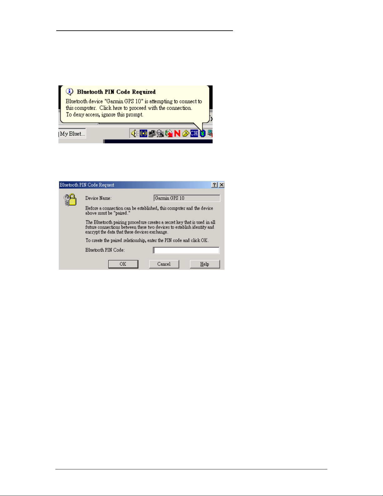
PIN Code
Some systems may or may not require a PIN Code in order to recognize the GPS 10x.
The default PIN code for GPS 10x is “1234”. When you initially make this connection or the connection is
terminated unexpectedly.
Just type “1234” and click OK.
190-00769-00 GPS 10x Technical Specifications Rev. A
Page 21
Page 26

For the latest free software updates (excluding map data) throughout the life of your
Garmin products, visit the Garmin Web site at www.garmin.com.
© Copyright 2006 Garmin Ltd. or its subsidiaries
Garmin International, Inc.
st
1200 East 151
Street, Olathe, Kansas 66062, U.S.A.
Garmin (Europe) Ltd.
Unit 5, The Quadrangle, Abbey Park Industrial Estate, Romsey, SO51 9DL, U.K.
Garmin Corporation
No. 68, Jangshu 2
nd
Road, Shijr, Taipei County, Taiwan
www.garmin.com
Part Number 190-00769-00 Rev. A
 Loading...