

Rev 8 Feb/2009 KMD 550/850 Quick Reference
1
B
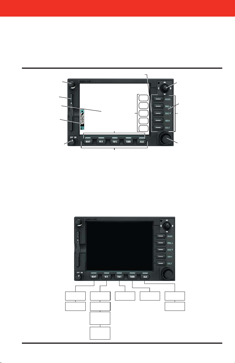
KMD 550/850 Multi-Function Display
Quick Reference
For Software Version 02/02 and Later
N
1. Brightness Control
2. Data Card
3. Display
4. Available Functions Legend
5. On/Off Control
6. Selected Function Indicators
7. Function Select Keys
8. Control Knobs (Inner and
Outer Knob)
9. Power Labels
10. Soft Labels
11. Joystick
12. Power Keys
13. Fault Indicator
FUNCTION SELECT KEYS
12
1
2
3
10
4
6
11
13
F
9
5
Topo On
Map
Topo Off
Map
WX Radar*
Stormscope
Datalink Wx
Graphical
Products
Datalink Wx
FIS Textual
Textual
Products
Products
8
7
EGPWSTAS/TCAS
Setup Pages
External
NTSC Video
2
Rev 8 Feb/2009
KMD 550/850 Quick Reference
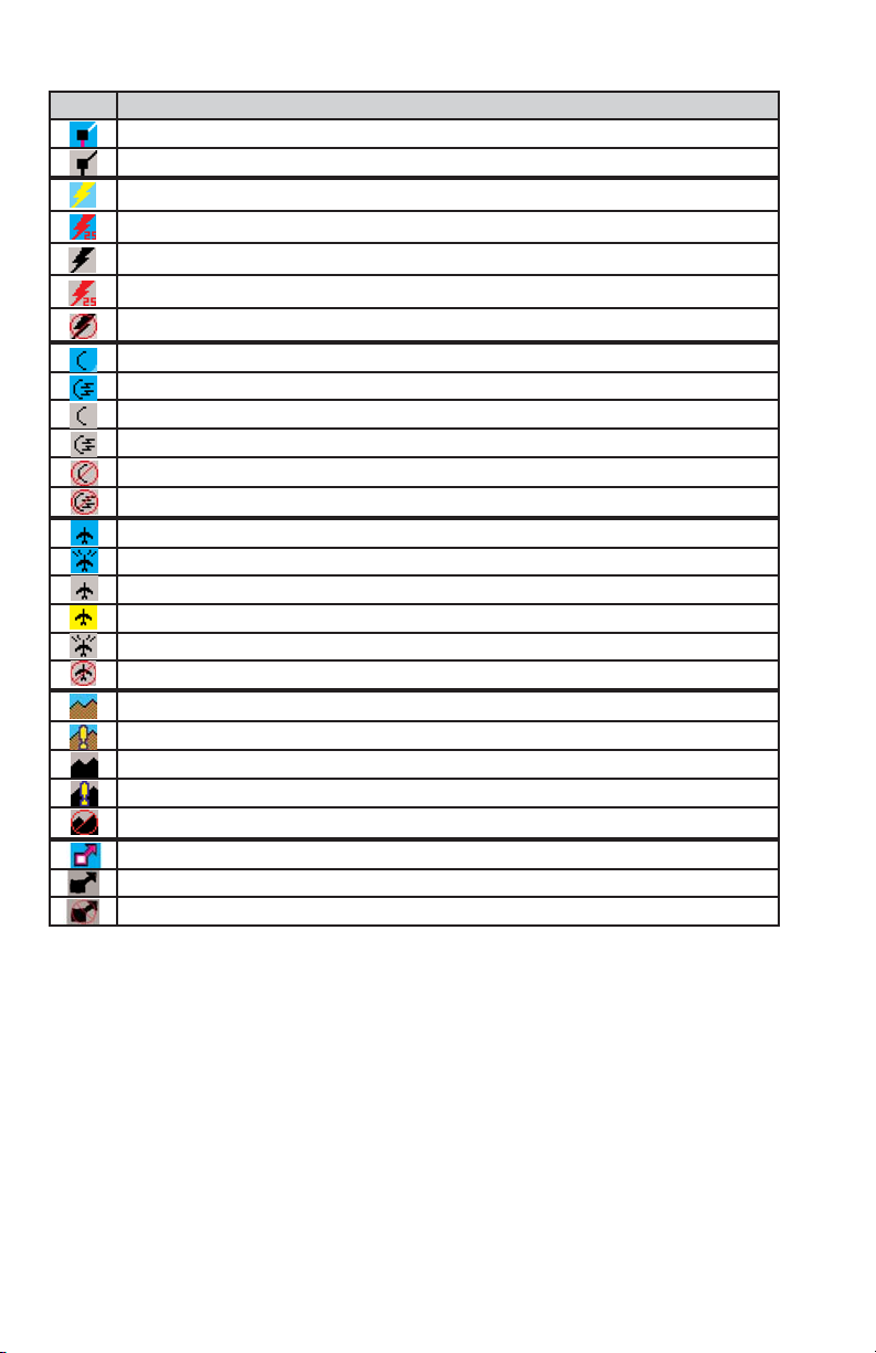
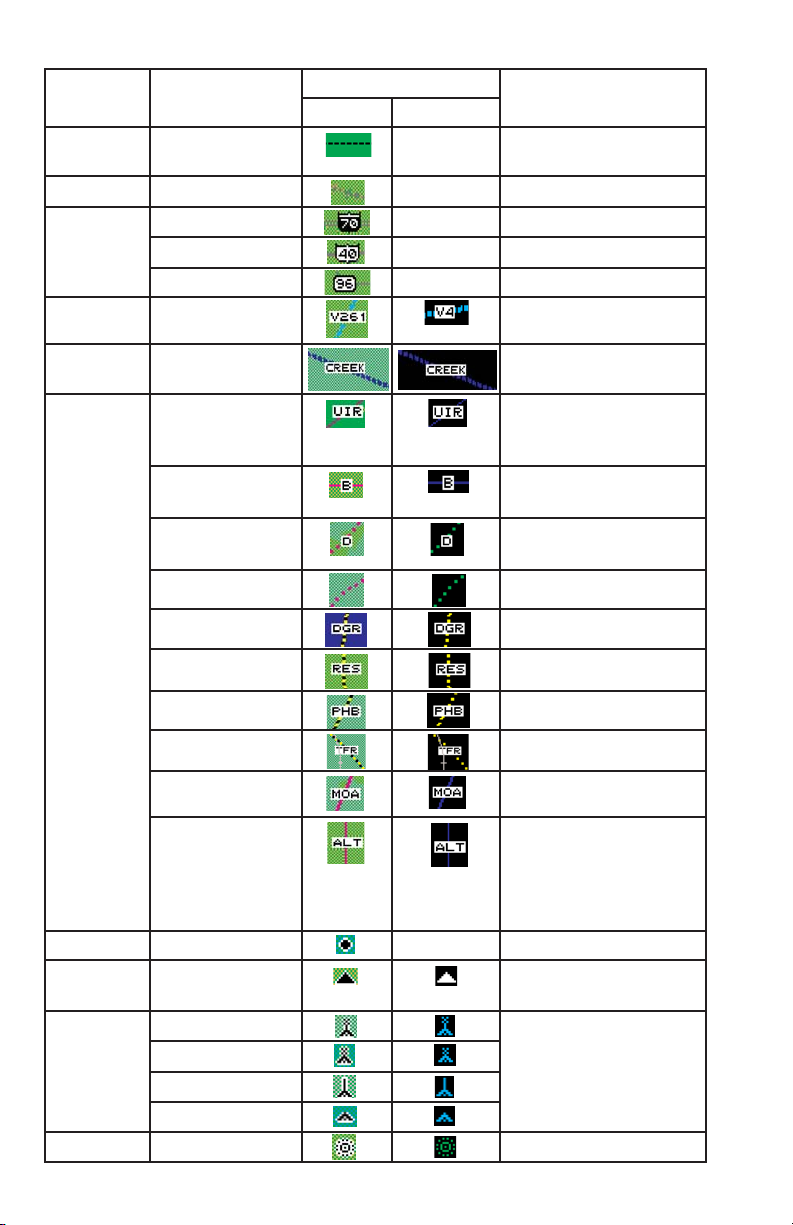
AVAILABLE FUNCTIONS ICONS
Icon
Description
Flight plan information being received and displayed.
Flight plan information being received but not displayed.
Stormscope®info being received and displayed.
Stormscope®info being received and displayed. Strikes have occurred within 25 nm.
Stormscope®info being received but not displayed.
Stormscope®info being received but not displayed. Strikes have occurred within 25 nm.
Stormscope®info not being received / data invalid.
Standby weather radar being displayed.
Active weather radar being displayed.
Weather radar in standby mode, not being displayed.
Weather radar in active mode, not being displayed.
Weather radar data invalid / not being received. Previously in standby.
Weather radar data invalid / not being received. Previously active.
Standby traffic sensor being displayed.
Active traffic information being displayed.
Traffic sensor in standby mode, not being displayed.
TIS service not available.
Traffic sensor active, not being displayed.
Traffic sensor data invalid / not being displayed.
EGPWS with warnings are enabled, being displayed.
EGPWS with warnings are disabled, being displayed.
EGPWS with warnings are enabled, not being displayed.
EGPWS with warnings are disabled, not being displayed.
EGPWS data invalid / not being received.
Severe Weather Storm track information being received and displayed.
Severe Weather Storm track information being received but not displayed.
Severe Weather Storm track information not being received / data invalid.
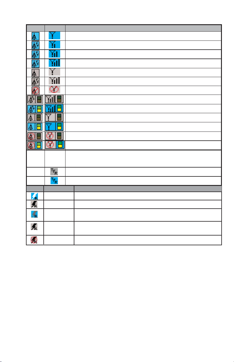
Rev 8 Feb/2009
3
KMD 550/850 Quick Reference
VDL XM
Description
No Wx data is currently being received but previously received data is being displayed.
Wx data is currently being received from a signal and displayed. XM signal is weak.
Wx data is currently being received from a signal and displayed. XM signal is marginal.
Wx data is currently being received from a signal and displayed. XM signal is good.
Wx data not being received nor displayed on present page.
Wx data is currently being received from a signal but not displayed on present page.
Fault with connection or data link radio.
Graphical METAR overlay is available but not displayed.
Graphical METAR overlay is enabled and displayed.
Wx data not being received. Graphical METAR overlay is available but not displayed.
Wx data not being received. Graphical METAR overlay is enabled and displayed.
Radio Fault. Graphical METAR overlay is available but not displayed.
Radio Fault. Graphical METAR overlay is enabled and displayed.
TFR data is not being received.
TFR data is being received but is not currently being displayed.
TFR data is being received and displayed.
Icon Description
0 min – 15 min Datalink lightning information received and displayed.
0 min – 15 min Datalink lightning Information received but not displayed.
15 min – 30 min Datalink lightning information received and displayed but data is more than
15 minutes old.
15 min – 30 min Datalink lightning information received but not displayed and data is more than
15 minutes old.
Unavailable Datalink lightning is not being received.
N/A No TFR
Icon
present.
N/A
N/A

4
Rev 8 Feb/2009
KMD 550/850 Quick Reference
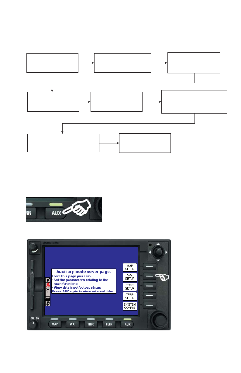
INTERACTION OF CONTROLS
AUX
Not
Active
Soft Key
Soft Key
Soft Key
Soft Key
Soft Key
Not
Active
Not
Active
* Not available in all configurations
TERR
Not Active
Selects Terrain
Warnings
Inhibited
* or
Enabled*.Active
Active
Sequence
through 120
˚ and
360
˚ views
(Default = 360
˚).
Active when over-
lays available.
Brings up overlay
select
Soft Keys.
Rotate to select
Tst, Nrm, Set
(Default = Nrm).
Not Active
TRFC
Not Active
Sequence through
Relative and
Absolute modes.
Active
Active
Sequence through
Normal, Above
and Below views.
Active when over-
lays available.
Brings up overlay
select
Soft Keys.
Rotate to select
Sby, Tst, On, Off.
Rotate to select
Mute On, Mute
Off.
WX - VDL/XM
Used to point at
items on map.
Displays SELECT
FIS PRODUCT
Menu.
Active
Active
Not Active
Active when overlays
available. Brings up
overlay select
Soft
Keys.
Rotate to select
report identifier. Also,
sequences Graphical
Weather Pages.
Rotate to select
report identifier. Also,
sequences Graphical
Weather Pages.
WX - Stormscope
®
Clears Strikes
Sequence through
Cell and Strike
modes.
Active
Active
Sequence through
120
˚ and 360˚
views.
Active when over-
lays available.
Brings up overlay
select
Soft Keys.
Not Active
Not Active
WX - Radar
Controls Tilt and
Track Line.
Sequence through
WX, WX/ARL*and GND
Mapping modes.
Active
Active
Sequence through
Horizontal and
Vertical Profile
*
views.
Active when over-
lays available.
Brings up overlay
select
Soft Keys.
Rotate to select
Sby, Tst, On, Set
(Default = Sby).
Gain control*
MAP
Used to point at any item on
map.
Soft Key
labeled RESET
STICK when joystick is
active.
Active
Active
Soft Key
labeled MORE
INFO when joystick is active
to get more info about items
pointed to on the map.
Active when overlays avail-
able. Brings up overlay
select
Soft Keys.
Rotate to bring up Airport
More Info page and select
the airport identifier.
Rotate to bring up Airport
More Info page and select
the airport identifier.
JOYSTICK
MODE
RNG
RNG
VIEW
OVLY
OUTER
KNOB
INNER
KNOB
Rev 8 Feb/2009
KMD 550/850 Quick Reference
5
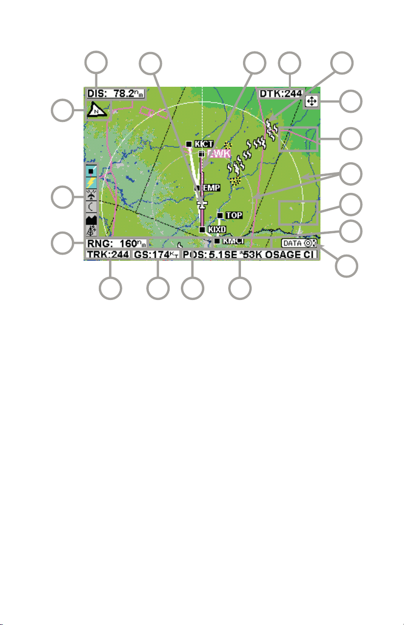
MAP FUNCTION
16
15
14
13 12
11
17
10
18
1
6
2 5
1 Display Range - RNG:####nm
2 Current Track - TRK:###
3 Current Ground Speed - GS:###kt
4 Distance to Pointer - PDIS: ###.#nm
5 Position Readout - Current aircraft position
6 Control Knob Label - Indicates Control Knob is active for data entry
7 Bearing to Pointer - PBRG: ###
8 MORE INFO Soft Label
9 Range Rings - Outer ring radius is selected range, inner ring radius is
one half the selected range
10 RESET STICK Soft Label
11 Joystick Label
12 Lightning Overlay
13 Desired Track - Active leg oriented to magnetic desired track (magenta)
14 GPS Flight Plan Overlay - Current GPS flight plan
15 Aircraft Symbol - Indicates present position. Stylized airplane when
heading input is present, a plus symbol with no heading.
16 Distance to Waypoint - DIS:###.#nm
17 North Pointer
18 Available Functions - Displays icons representing data available (black)
and displayed (color)
3
4
9
8
7
6
Rev 8 Feb/2009
KMD 550/850 Quick Reference
MAP ICONS
Feature Conditions Map Icons Other Characteristics
TOPO on TOPO off
Political
Boundary
Not displayed
Railway Not displayed
Roads Major Not displayed
Prime Not displayed
Other Not displayed
Victor
Airways
Heliroutes
Airspace
Boundary
FIR/UIR Boundary label will be FIR,
UIR, or F/U per airspace
type.
Class A/B/C Boundary label will be A, B,
or C per airspace type.
Class D/E/F/G Boundary label will be D, E,
F or G per airspace type.
Class Unknown
Danger Boundary label will be DGR.
Restricted Boundary label will be RES.
Prohibited Boundary label will be PHB.
MOA/MATZ Boundary label will be MOA
or MATZ per airspace type.
Other SUA (Radar
Area, Alert, Caution,
Training, Warning or
Unspecified/
Unknown)
Boundary label will be ALT,
CTN, DGR, MOA, PHB,
RES, TNG, WNG, ADV,
CBA, TRA, TSA, or UNK.
Cities Not displayed
Intersections
(INTs)
Obstacles Lighted - Tall Label will indicate MSL ele-
vation followed by AGL ele-
vation in parentheses [e.g.
“1546 (590)”]. Tall is defined
as over 1,000 ft. AGL.
Lighted - Short
Unlighted - Tall
Unlighted - Short
NDBs
Temporary Flight
Restrictions
Boundary label will be TFR.
Rev 8 Feb/2009 KMD 550/850 Quick Reference
7
OVERLAYING DATA
OVERLAY TYPE
MMOODDEE FFLLIIGGHHTT PPLLAANN SSTTOORRMMSSCCOOPPEE®®TTRRAAFFFFIICC MMEETTAARR DDAATTAA LLIINNKK SSCCIITT TTFFRR
LLIIGGHHTTNNIINNGG
MAP - TOPO ON Yes Yes
1
Yes
2
Yes No No Yes
5
MAP - TOPO OFF Yes Yes
1
Yes
2
Yes No No Yes
5
WX - Weather Radar Yes
1
Yes Yes
3
No No No No
WX - Stormscope
®
Yes
1
N/A No No No No No
WX - NEXRAD Yes Yes
1
Yes No Yes Yes No
WX - Precipitation Type
5
Yes No No No Yes Yes No
WX - Freezing Levels
5
Yes No No No No No No
WX - Winds Aloft
5
Yes No No No No No No
WX - Graphical METAR Yes No No N/A No No No
WX - Graphical AIRMET Yes Yes
1
No No No No No
WX - Graphical SIGMET Yes Yes
1
No No No No No
WX - Graphical Convective Yes Yes
1
No No No No No
SIGMET
WX - Graphical Wx Watches Yes
4
Yes
1, 4
No No No No No
TERR Yes Yes
1
Yes
2
No No No No
TRFC Yes
1
No N/A No No No No
1 Requires remote heading input 3 TIS requires remote heading input 5 Not available with VHF
2 TCAS/TAS requires remote heading input 4 Not available with XM Datalink FIS
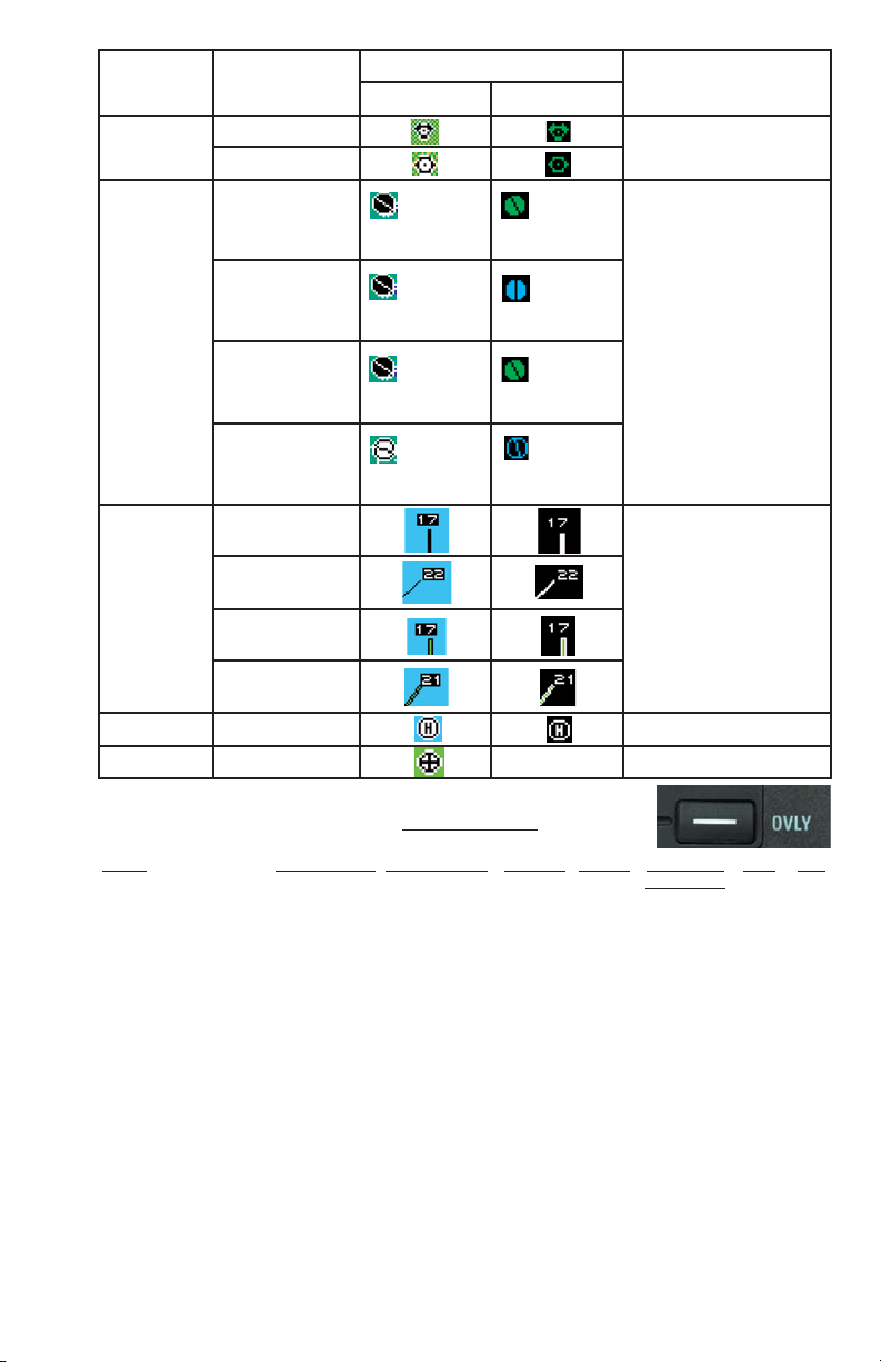
Feature Conditions Map Icons Other Characteristics
TOPO on TOPO off
VORs With DME
Without DME
Airports Hard runway +
IFR approach
Line represents
primary runway
Line represents
primary runway
If the database does not
have runways for the airport, then the icon will not
indicate a runway (no line
will be displayed).
Hard runway, no
IFR approach
Line represents
primary runway
Line represents
primary runway
IFR approach
available
Line represents
primary runway
Line represents
primary runway
Soft or unknown
runways
Line represents
primary runway
Line represents
primary runway
Airport
Runways
Primary, hard
surface
Runways are shown for
airports within 5 nm of
current position and
selected range is 10 nm
or less. Runway ends are
labeled with the proper
runway identifier if
selected range is 1 nm.
Other hard surface
Primary soft surface
Other soft surface
Helipads
VRPs Not displayed

WEATHER RADAR
AVAILABLE WEATHER RADAR FUNCTION ICONS
8
Rev 8 Feb/2009
KMD 550/850 Quick Reference
Icon Description
Standby weather radar being displayed.
Active weather radar being displayed.
Weather radar in standby mode, not being displayed.
Weather radar in active mode, not being displayed.
Weather radar data invalid / not being received. Previously in standby.
Weather radar data invalid / not being received. Previously active.
56
7
8
4
3
9
10
1 Aircraft Symbol
2 Knob Function Label - Rotating the outer knob selects between
Standby (SBY), Test (TST), ON and SET modes.
3 Display Range Indications
4 Tilt Angle - XX.X Degrees up (U) or down (D).
5 Joystick Function Label - Moving the joystick up and down adjusts
the radar tilt. Moving the joystick left and right adjusts the location of
the yellow track line.
6 Stabilization Indication
7 Track Angle
8 WX Radar Mode Indication - TEST, WX, WX/ARL (Auto Range Limiting
or MAP (Ground Mapping Mode)
9 Available Functions - Displays icons representing data available
(black) and displayed (color)
10 Fault Message Window - See Error and Fault Messages
1
2
Rev 8 Feb/2009 KMD 550/850 Quick Reference
9
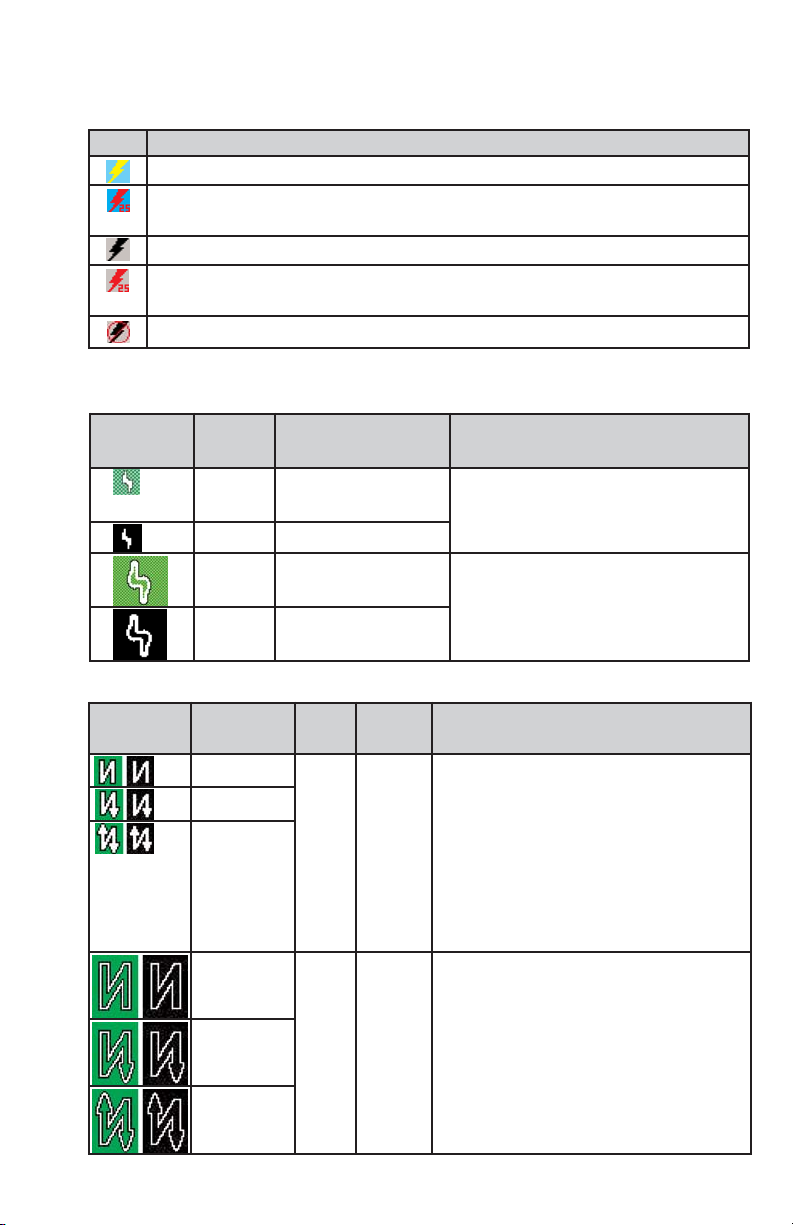
STORMSCOPE
AVAILABLE STORMSCOPE FUNCTION ICONS
LIGHTNING ICONS
WX-500
WX-1000E
Icon Description
Stormscope®information being received and displayed.
Stormscope®information being received and displayed. Strikes have occurred within
25 nm.
Stormscope®information being received but not displayed.
Stormscope®information being received but not displayed. Strikes have occurred
within 25 nm.
Stormscope®information not being received / data invalid.
Lightning
Icon
Color Used on Pages Additional Requirements
White MAP (TOPO-ON or
TOPO-OFF)
The small solid icon is used when
the display selected range is 25 nm
or greater.
White WX, TRFC, TERR
White
Outline
MAP (TOPO-ON or
TOPO-OFF)
The large outlined icon is used when
the display selected range is less
than 25 nm.
White
Outline
WX, TRFC, TERR
Lightning
Icon
Intensity
Level
Color Used on
Pages
Comments
1 (Light) White
with
black
border
MAP,
WX,
TERR
The small solid icon is used when the display selected range is 25 nm or greater.
The WX-1000E indicates areas of lightning
detected (not individual discharges). Light
activity (level 1) is an area with up to 8
strikes/minute; moderate (level 2) is an area
with 9-25 strikes/minute and heavy (level 3)
is an area with 26 or more strikes/minute.
2 (Moderate)
3 (Heavy)
1 (Light) White
with
black
border
MAP,
WX,
TERR
The large outlined icon is used when the
display selected range is less than 25 nm.
The larger icon reminds the user that the
accuracy of lightning placement is not as
good as that suggested by the map scale.
2 (Moderate)
3 (Heavy)
10
Rev 8 Feb/2009
KMD 550/850 Quick Reference
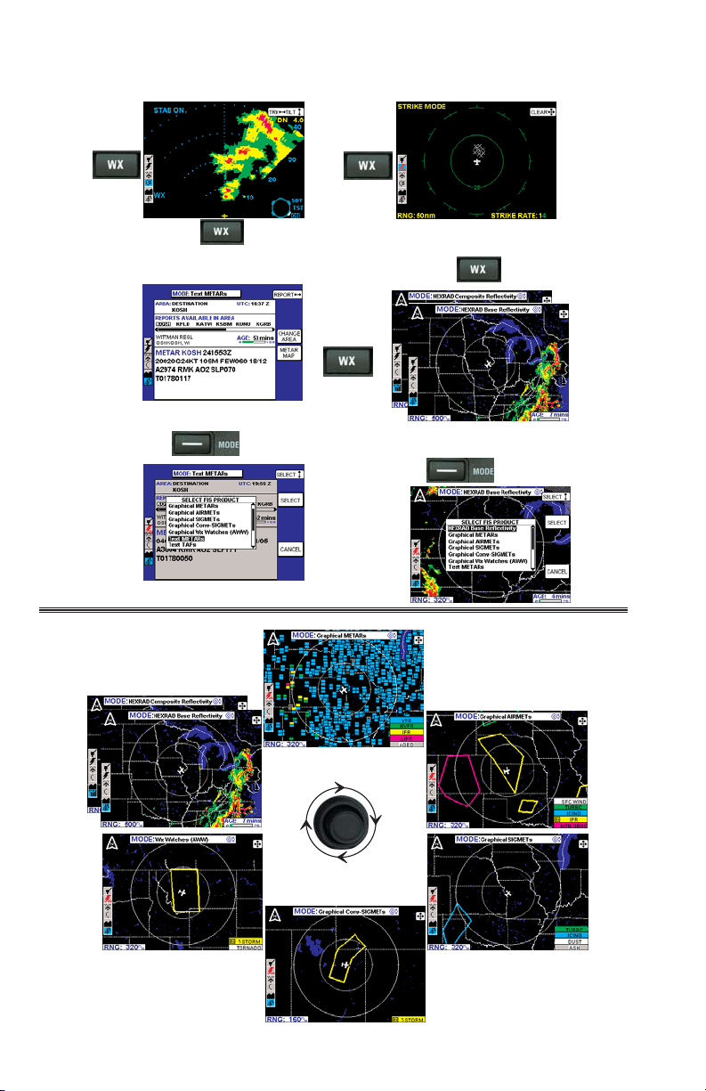
FIS VDL AND XM
DATALINK WEATHER
☞
No AWWs for XM
No AWWs for XM
** NEXRAD Composite with XM
NEXRAD Base with VDL
** NEXRAD Composite with XM
NEXRAD Base with VDL
☞
☞
☞
☞
☞
☞
Rev 8 Feb/2009 KMD 550/850 Quick Reference
11
SUBSCRIBING TO VDL SERVICES
NOTE: The following details require selection of a KDR-510 as the source
for datalink weather data.
SETTING UP A VDL SUBSCRIPTION
Get Display ID
from unit in airplane
Select the desired
services
Update Data Card if needed.
Update at least once per year
to ensure continued FIS Services
Go to Bendixking.com
or call 1-800-247-0230
to subscribe to FIS Services
Receive Subscription
Code(s) and print them
out
Enjoy flying with FIS
Services!
Enter Display ID during
registration
(This is only required first
time you subscribe)
Take printed out code(s)
to the airplane and enter
code(s) on the FIS Subscription
Status Page

12
Rev 8 Feb/2009
KMD 550/850 Quick Reference
Note the FIS Display ID and contact Wingman Services at
www.bendixking.com or call 1-800-247-0230. This ID is used to obtain the
Subscription Code. After obtaining the Subscription Code press the ADD
SUBSCR Key.

Rev 8 Feb/2009 KMD 550/850 Quick Reference
13
Use the inner knob to enter characters and the outer knob to move to the
next field.
After the last character is entered, press the ENTER Key. After the subscription is accepted it will be displayed.

14
Rev 8 Feb/2009
KMD 550/850 Quick Reference
CHECKING VDL SUBSCRIPTIONS
NOTE: Only the validity period for subscriptions is shown on the display. To
determine which products are available with each subscription, access the
account on Wingman Services at www.bendixking.com.
Symbol Status Description
Unknown The system time is not known or no subscription is programed.
Future The current system time is prior to the displayed starting date.
This subscription is not valid for enabling access to FIS today
but it will become valid at some point in the future.
Valid The current system time is after the displayed starting date and
before the displayed ending date.
Almost Expired The current system time is within seven (7) days of the dis-
played ending date.
Expired The current system time is beyond the displayed ending date.

Rev 8 Feb/2009 KMD 550/850 Quick Reference
15
XM WX SUBSCRIPTIONS
An XM subscription must be set up to receive XM WX services. This
process involves accessing the XM Radio website and a toll-free phone call
to XM Radio.
SETTING UP AN XM WX SUBSCRIPTION
NOTE: The following details require selection of an XM receiver (such as a
KDR-610) as the source for datalink weather data.
Setting up an XM WX subsrcription can be accomplished by following these
steps:
1a.Retrieve the 8-digit ID from the KDR 610 label (should be attached to the
opposite end of the receiver from the connectors)
OR
1b.Apply power to the display and receiver, select the AUX key, the WX
Setup softkey, the FIS softkey, and finally the FIS Subscription softkey.
Record the 8-digit receiver ID displayed at the bottom of the FIS
Subscription Status page.
2. Go to the website
www.xmradio.com/weather
to select your weather
subscription package.
3. Apply power to the XM receiver, and place the receiver's antenna where
the signal can be received from the XM satellites. Make certain the
antenna has a good view of the southern horizon.
4. With the Receiver ID and desired subscription package in hand, contact
XM Radio at 1-800-985-9200 for assistance in activating your receiver
and setting up a weather product subscription. The receiver should
remain in view of the satellites during the subscription process.

16
Rev 8 Feb/2009
KMD 550/850 Quick Reference
5. Verify the activation of the receiver and the subscription validity by
selecting and viewing the “FIS Subscription Status Page” on the KMD
screen.
If for any reason the receiver was not exposed to the XM signal within the
initial 24 hour broadcast period, or is not successfully authorized for some
other reason, a subsequent 15 minute resend of the subscription information can be obtained. Get the receiver ID (instructions in step 1a or 1b
above), go to the website
http://www.xmradio.com/refresh/
, and follow the
instructions.
CHECKING XM WX SUBSCRIPTIONS
To check the FIS XM subscription and receiver status, apply power to the
display and receiver, select the AUX key, then the WX SETUP softkey, the
FIS softkey, and finally the FIS SUBSCR softkey, as in step 1b previously.
The Application IDs are displayed along with the receiver
activation and subscription
status. The Application IDs provide the groupings of products
that are part of the subscription
package. Green checkmarks
indicate those App IDs or
product groups that are contained in the subscription
package for the XM receiver.
Contact XM Radio at 1-800-9859200 with the App ID information if the subscribed products are not received and displayed.
Symbol Subscription Status Description
—
(white)
No Information
The XM FIS receiver subscription
information message has not been
received.
Not Subscribed
The user is not authorized for the
Application ID.
Subscribed
The user is authorized for the
Application ID.

AVAILABLE FIS FUNCTION ICONS
Rev 8 Feb/2009 KMD 550/850 Quick Reference
17
VDL XM
Description
No Wx data is currently being received but previously received data is being displayed.
Wx data is currently being received from a signal and displayed. XM signal is weak.
Wx data is currently being received from a signal and displayed. XM signal is marginal.
Wx data is currently being received from a signal and displayed. XM signal is good.
Wx data not being received nor displayed on present page.
Wx data is currently being received from a signal but not displayed on present page.
Fault with connection or data link radio.
Graphical METAR overlay is available but not displayed.
Graphical METAR overlay is enabled and displayed.
Wx data not being received. Graphical METAR overlay is available but not displayed.
Wx data not being received. Graphical METAR overlay is enabled and displayed.
Radio Fault. Graphical METAR overlay is available but not displayed.
Radio Fault. Graphical METAR overlay is enabled and displayed.
TFR data is not being received.
TFR data is being received but is not currently being displayed.
TFR data is being received and displayed.
N/A No TFR
Icon
present.
N/A
N/A
App ID Product
App ID 10
Radar Coverage, METARs, County Warnings, City
Forecasts
App ID 231 NEXRAD Radar, TAFs, Freezing Level, TFRs
App ID 232
SCITs, Lightning, Storm (Echo) Tops, Surface
Precipitation, Winds Aloft, AIRMETs, SIGMETs,
Cloud Tops

18
Rev 8 Feb/2009
KMD 550/850 Quick Reference
NEXRAD INTENSITY
Precipitation intensity is depicted using colors as follows:
Magenta Intense Level 5-8 50+ dBz
Red Heavy Level 3-4 40-50 dBz
Yellow Moderate Level 2 30-40 dBz
Green Light Level 1 15-30 dBz (VDL)
10-30 dBz (XM)
NEXRAD PAGE
4
3
2
5
6
1
VDL System
4
3
2
1
5
6
XM WX System
10 Aircraft Symbol - Indicates present aircraft position and heading (if
available) or track.
11 Age of Data - Age of the data based on current time minus NEXRAD
issue time.
12 Age Status Bar - Indicates percentage of age versus elapsed time
before expiration. The bar will be green the first 50% then turn yellow.
1 Range Scale - Indicates
selected range.
7
2 Available Functions -
Displays icons representing
8
data available (black) and
displayed (color).
9
3 North Pointer - Indicates
10
11
12
10
11
12
north.
4 Range Rings - Outer ring
radius is selected range
and inner ring radius is one
half the selected range.
5 MODE - Indicates the
weather produ
displayed.
6 Control Knob Icon -
7
Displayed when the Control
Knobs are available for
cycling through the graphical
9
weather products.
7 Joystick Label - Indicates
joystick is active and can be
used to pan map.
8 No Coverage Area -
Crosshatch pattern indicates
area of no coverage.
9 Precipitation - NEXRAD
precipitation returns.
ct being

Rev 8 Feb/2009 KMD 550/850 Quick Reference
19
1 Range Scale - Indicates selected range.
2 Available Functions - Displays icons representing data available (black)
and displayed (color).
3 Age Status Bar - Indicates percentage of age versus elapsed time before
expiration. The bar will be green the first 50% then turn yellow.
4 North Pointer - Indicates north.
5 MODE - Indicates the weather product being displayed.
6 Control Knob Icon - Displayed when the Control Knobs are available for
cycling through the graphical weather products.
7 Joystick Label - Indicates joystick is active and can be used to pan map.
8 Range Rings - Outer ring radius is selected range and inner ring radius
is one half the selected range.
9 Aircraft Symbol - Indicates present aircraft position and heading (if
available) or track.
10 No Coverage Data Available - Indicates there is not any Freezing Levels
available in that area.
4
2
9
5
1
3
7
8
6
PRECIPITATION TYPE
PRECIPITATION TYPE COLOR CODING

20
Rev 8 Feb/2009
KMD 550/850 Quick Reference
1 Range Scale - Indicates selected range.
2 Available Functions - Displays icons representing data available (black)
and displayed (color).
3 Age Status Bar - Indicates percentage of age versus elapsed time before
expiration. The bar will be green the first 50% then turn yellow.
4 North Pointer - Indicates north.
5 MODE - Indicates the weather product being displayed.
6 Control Knob Icon - Displayed when the Control Knobs are available for
cycling through the graphical weather products.
7 Joystick Label - Indicates joystick is active and can be used to pan map.
8 Range Rings - Outer ring radius is selected range and inner ring radius is
one half the selected range.
9 Aircraft Symbol - Indicates present aircraft position and heading (if
available) or track.
10 Freezing Level Color Key - Colors indicating Freezing Levels at the
height shown.
4
2
9
5
1
3
7
8
6
FREEZING LEVELS
FREEZING LEVELS COLOR CODING

Rev 8 Feb/2009 KMD 550/850 Quick Reference
21
1 Range Scale - Indicates selected range.
2 Available Functions - Displays icons representing data available (black)
and displayed (color).
3 Age Status Bar - Indicates percentage of age versus elapsed time before
expiration. The bar will be green the first 50% then turn yellow.
4 North Pointer - Indicates north.
5 MODE - Indicates the weather product being displayed.
6 Control Knob Icon - Displayed when the Control Knobs are available for
cycling through the graphical weather products.
7 Joystick Label - Indicates joystick is active and can be used to pan map.
8 Range Rings - Outer ring radius is selected range and inner ring radius is
one half the selected range.
9 Aircraft Symbol - Indicates present aircraft position and heading (if
available) or track.
10 FL UP and FL DN – Increments the Winds Aloft flight level that is being
played.
4
2
9
5
1
3
7
8
6
WINDS ALOFT
WINDS ALOFT SCALE

22
Rev 8 Feb/2009
KMD 550/850 Quick Reference
GRAPHICAL METAR PAGE
GRAPHICAL METAR COLOR CODING
5
6
7
4
3
8
9
2
10
1
1 Range Scale - Indicates selected range.
2 Available Functions - Displays icons representing data available (black)
and displayed (color).
3 Graphical METAR Icon - Ceiling indicated in top box, visibility in the
bottom box and ICAO identifier of issuing airport. Note that ICAO identifiers
are not displayed on all range settings.
4 North Pointer - Indicates north.
5 MODE - Indicates the weather product
6 Control Knob Icon - Displayed when the Control Knobs are available for
cycling through the graphical weather products.
7Joystick Label - Indicates joystick is active and can be used to pan map.
8 Range Rings - Outer ring radius is selected range and inner ring radius
is one half the selected range.
9 Aircraft Symbol - Indicates
available) or track.
10 METAR Color Key - Colors indicating flight rules pertaining to ceiling
and visibility.
present aircraft position and heading (if
being displayed.

GRAPHICAL AIRMET PAGE
Rev 8 Feb/2009 KMD 550/850 Quick Reference
23
4
5
6
3
7
8
2
9
10
1
1 Range Scale - Indicates selected range.
2 Available Functions - Displays icons representing data available (black)
and displayed (color).
3 North Pointer - Indicates north.
4 MODE - Indicates the weather product being displayed.
5 Control Knob Icon - Displayed when the Control Knobs are available for
cycling through the graphical weather products.
6Joys
7 Range Rings - Outer ring radius is selected range and inner ring radius
8 Aircraft Symbol - Indicates present aircraft position and heading (if
9 AIRMET Boundary - Color coded line indicating the boundaries of an
10 AIRMET Color Key
11 IN - Indicates the current aircraft position is ìIN ” an IFR AIRMET.
tick Label - Indicates joystick is active and can be used to pan map.
is one half the selected range.
available) or track.
AIRMET.
- Colors indicating AIRMET type.
11

24
Rev 8 Feb/2009
KMD 550/850 Quick Reference
GRAPHICAL SIGMET PAGE
4
5
6
3
7
8
2
1
1 Range Scale - Indicates selected range.
2 Available Functions - Displays icons representing data available (black)
and displayed (color).
3 North Pointer - Indicates north.
4 MODE - Indicates the weather product being displayed.
5 Control Knob Icon - Displayed when the Control Knobs are available for
cycling through the graphical weather products.
6Joys
7 Range Rings - Outer ring radius is selected range and inner ring radius
8 Aircraft Symbol - Indicates present aircraft position and heading (if
9 SIGMET Boundary - Color coded line indicating the boundaries of a
10 SIGMET Color Key - Colors indicating SIGMET type.
tick Label - Indicates joystick is active and can be used to pan map.
is one half the selected range.
available) or track.
SIGMET.
9
10

Rev 8 Feb/2009 KMD 550/850 Quick Reference
25
GRAPHICAL CONVECTIVE SIGMET PAGE
4
5
6
3
7
8
2
9
10
1
11
1 Range Scale - Indicates selected range.
2 Available Functions - Displays icons representing data available (black)
and displayed (color).
3 North Pointer - Indicates north.
4 MODE - Indicates the weather product being displayed.
5 Control Knob Icon - Displayed when the Control Knobs are available for
cycling through the graphical weather products.
6Joys
7 Range Rings - Outer ring radius is selected range and inner ring radius
8 Aircraft Symbol - Indicates present aircraft position and heading (if
9 Convective SIGMET Boundary - Color coded line indicating the boundaries
10 IN - Indicates the current aircraft position is “IN” a thunderstorm Convective
11 Convective SIGMET Color Key - Colors indicating Convective SIGMET
tick Label - Indicates joystick is active and can be used to pan map.
is one half the selected range.
available) or track.
of a Convective
SIGMET.
type.
SIGMET.

26
Rev 8 Feb/2009
KMD 550/850 Quick Reference
GRAPHICAL ALERT WEATHER WATCHES PAGE (AWW)
(VDL ONLY)
4
5
6
3
7
8
2
9
10
1
11
1 Range Scale - Indicates selected range.
2 Available Functions - Displays icons representing data available (black)
and displayed (color).
3 North Pointer - Indicates north.
4 MODE - Indicates the weather product being displayed.
5 Control Knob Icon - Displayed when the Control Knobs are available for
cycling through the graphical weather products.
6Joys
7 Range Rings - Outer ring radius is selected range and inner ring radius
8 Aircraft Symbol - Indicates present aircraft position and heading (if
9 Weather Watch Boundary - Color coded line indicating the boundaries
10 IN - Indicates the current aircraft position is “IN” a severe thunderstorm
11 Weather Watch Color Key - Colors indicating Alert Weather Watch type.
tick Label - Indicates joystick is active and can be used to pan map.
is one half the selected range.
available) or track.
of an Alert Wea
watch area.
ther Watch.

Rev 8 Feb/2009 KMD 550/850 Quick Reference
27
FIS TEXT PAGE
1 Text Field - The translated METARS data is displayed first in this window
followed by the encoded weather report is displayed in this field.
2 Available Functions - Displays icons representing data available (black)
and displayed (color).
3 Selected Report Info - Displays name, city and state of selected report.
4 Selected Area Identifier - Displays the identifier of the area selection.
5 Area Selection - Pressing the CHANGE AREA soft key cycles between
Destination, Flightplan WPT, Nearest and User Defined.
6 Mode - Pressing the MODE key will display the SELECT FIS PRODUCT
Menu.
7 UTC - Current UTC time.
8 Report - Each horizontal movement of the joystick will move the cursor
over the next report in the AVAILABLE REPORTS field.
9 Available Reports - Shows available reports based on the selection in the
AREA field. Special, urgent or amended reports are highlighted in yellow.
10 Scroll Bar Left/Right - Indicates there are more available reports than can
be displayed on the screen. Move the joystick left/right to cycle through the
reports.
11 Change Area Soft Key - Cycles the AREA field between Destination,
Flightplan Waypoint (FLPN WPT), Nearest and User Defined.
12 METAR Map Soft Key - When this key is pressed the graphical METAR
page is displayed with the map centered on the selected METAR. This is
only available when valid data for graphical METARs is being received.
13 Age of Report - Age of report based on UTC time minus time of report.
The bar indicates percentage of age versus elapsed time before expiration.
The bar will be green the first 50% then turn yellow.
14 Knob Function Label - Indicates the knob function is set to DATA input
(USER DEFINED) or SCAN data (FLPN WPT).
15 Scroll Bar Up/Down - Indicates there is more available data in this report
than can be displayed on the screen. Move the joystick Up/Down to cycle
through the reports.
6
7
8
5
9
4
10
3
11
13
2
12
15
1
14

28
Rev 8 Feb/2009
KMD 550/850 Quick Reference
METARs
TAFs
PIREPs & Area Products
Radius in Nautical Miles of Selected Area
0 50 100 150
Selected Area
☞
☞
☞
☞

Rev 8 Feb/2009 KMD 550/850 Quick Reference
29
TRAFFIC AVOIDANCE
AVAILABLE TRAFFIC FUNCTION ICONS
TCAS/TAS SYMBOLOGY
NON-THREAT TRAFFIC
PROXIMITY INTRUDER TRAFFIC
TRAFFIC ADVISORY (TA)
RESOLUTION ADVISORY (RA)
“NO-BEARING” TRAFFIC
Icon Description
Standby traffic sensor being displayed.
Active traffic information being displayed.
Traffic sensor in standby mode, not being displayed.
TIS service not available.
Traffic sensor active, not being displayed.
Traffic sensor data invalid / not being displayed.

4
30
Rev 8 Feb/2009
KMD 550/850 Quick Reference
3
5
6
7
8
2
1
1 Display Range - RNG:##nm
2 TAS (TCAS) Operating Mode - TAS (TCAS) TST, TAS (TCAS) SBY,
TA Only, TA/RA or TAS (TCAS) Fail
3 Available Functions - Displays icons representing data available (black)
and displayed (color)
4 Current Flight Level - FL:###
5 Altitude Volume - NORMAL, ABOVE, BELOW or UNRESTRICTED (not
available in all configurations)
6 Traffic Intruder Symbols - Indicates type of traffic, altitude of traffic and
vertical trend of traffic.
7 “No Bearing” Intruder Dispay Area - AA #.#NM ±XX↕ (Where AA is TA
or RA)
8 Range Rings - Outer ring radius is selected range, inner ring radius is
always two nautical miles
9 Outer Knob Icon - Shows current knob selection
10 Aircraft Symbol - Stylized airplane indicating aircraft position
10
9

Rev 8 Feb/2009 KMD 550/850 Quick Reference
31
Covered by US Pat. 6512975
TIS SYMBOLOGY
PROXIMITY INTRUDER TRAFFIC
PROXIMITY INTRUDER NON-ALTITUDE REPORTING
(NAR) TRAFFIC
TRAFFIC ADVISORY (TA)
TRAFFIC ADVISORY NON-ALTITUDE REPORTING (NAR)
TIS Capable Mode S Radar Sensor Sites

32
Rev 8 Feb/2009
KMD 550/850 Quick Reference
4
3
5
6
7
2
1
1 Display Range - RNG:##nm
2 TIS Operating Mode - TIS ON, TIS OFF or TIS FAIL
3 Available Functions - Displays icons representing data available (black)
and displayed (color).
4 Current Flight Level - FL:###
5 Display Orientation - When in magnetic heading-up orientation, Mag###°
Hdg; when in magnetic track-up orientation, Mag###° Trk; when heading
or track is not available from the system, No Hdg or Trk. The received traffic
bearing and ground track is corrected when the system has heading or track.
6 Traffic Intruder Symbols - Indicates type of traffic, altitude of traffic, vertical
trend of traffic and ground track of traffic.
7 Range Rings - Outer ring radius is selected range, inner ring radius is
always two nautical miles.
8 Knob Icon - Outer knob selects TIS ON or OFF. Inner knob selects MUTE
ON or MUTE OFF for muting of “TIS Unavailable” audio message.
9 Aircraft Symbol - Stylized airplane indicating aircraft position.
9
8

Rev 8 Feb/2009 KMD 550/850 Quick Reference
33
TERRAIN AVOIDANCE
AVAILABLE TERRAIN FUNCTION ICON
Icon Description
EGPWS with warnings enabled, being displayed.
EGPWS with warnings disabled, being displayed.
EGPWS with warnings enabled, not being displayed.
EGPWS with warnings disabled, not being displayed.
EGPWS data invalid / not being received.
89
7
6
10
5
11
1 4
1 Display Range - RNG:###nm
2 Terrain Awareness State - Displays EGPWS TEST when self-test is active, TERR
FAIL when terrain is INOP due to a fault, TERR N/A when terrain is not available
(no fault) and TERR INHBT when Terrain Awareness Warnings have been manually
inhibited. The terrain picture will be blacked out if the state is TERR FAIL or TERR
N/A (Some installations will also be blacked out for TERR INHBT).
3 Aircraft Symbol - Stylized airplane except in north-up mode when it is a plus
symbol. Indicates present position.
4 Outer Rotary Knob (not present for all installations) - Allows selection of Normal
(NRM), Test (TST) or Settings (SET) mode. Default is Normal.
5 Range Rings - Outer ring radius is selected range, inner ring radius is one half
the selected range. Value of inner ring displayed at bottom of inner ring in 360°
views and at the left edge of the inner ring in 120° views.
6 EGPWS Peaks Elevation (not present for all installations) - Maximum peaks
elevation displayed over Minimum peaks elevation, #####
7 GPS Flight Plan Overlay - Current GPS flight plan.
8 Display Orientation - When in magnetic heading-up orientation, Mag###° Hdg;
when in true heading-up orientation, Tru###° Hdg; when in magnetic track-up
orientation, Mag###° Trk; when in true track-up orientation, Tru###° Trk; when in
north- up orientation, NORTH
9 EGPWS Geometric Altitude (not present for all installations) - ##### MSL (Mean
Sea Level) or ##### GSL (Geodetic Sea Level) depending on system configuration.
10Check Altitude Flag Window - CHECK ALT
11Icon Bar - Icons representing data available (black) and displayed (color).
2
3

N
Honeywell Aerospace
Business and General Aviation
Honeywell International Inc.
One Technology Center
23500 West 105th Street
Olathe, KS 66061
Telephone: (913) 712-0400
FAX: (913) 712-1302
www.honeywell.com
006-18223-0000
Rev. 8 02/09
© 2000-2009 Honeywell International Inc.
 Loading...