

Page 1
DIRECT TOs (not available in External GPS Mode)
A DIRECT TO provides navigation from your present position to a single
waypoint. The destination waypoint can be defined from the database or
using the joystick to point to a desired location on the map.
Visual DIRECT TO
• In Map Mode use the joystick to move the pointer to the desired location,
(Note that the information at the bottom of the display indicates distance,
bearing, and estimated time enroute from present position to the pointer.)
• Press the DIRECT TO key to activate a Direct To the point selected.
B
KMD 150 MFD
Getting Started Sheet
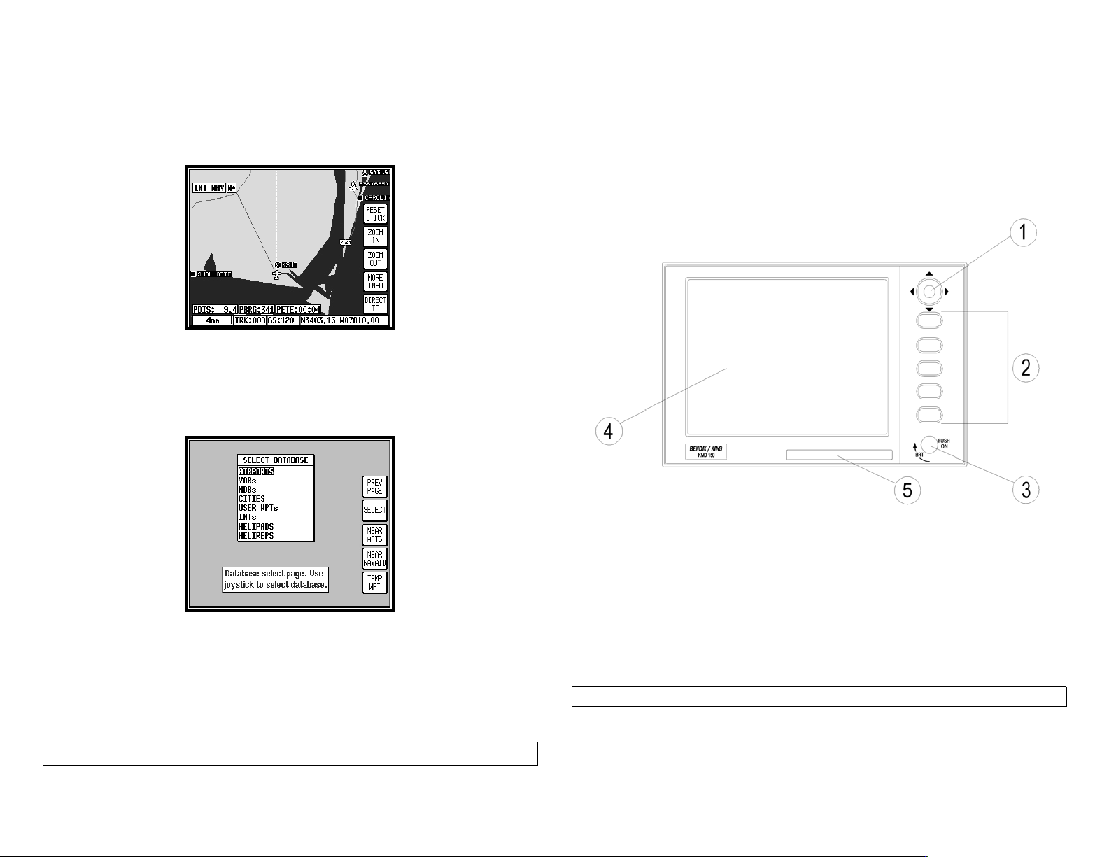
KMD 150 Front View
1. Joystick
2. Function Keys (Functions correspond to labels on the display)
3. ON / OFF / Brightness control
4. Full Color TFT Liquid Crystal Display
5. Database Card
DIRECT TO a Database Waypoint
• Press the DIRECT TO key.
• Use the joystick to select the desired type of waypoint and press the
SELECT key.
• Use the joystick to enter the identifier of the waypoint
• Press the ENTER key to activate a Direct To the selected waypoint.
To cancel a DIRECT-TO press the DIRECT TO OFF key
006-18221-0000 006-18221-0000
Rev 1 Apr/06 Rev 1 Apr/06
TO TURN ON
• Ensure Database Card is fully inserted with label up
UNIT WILL NOT OPERATE WITHOUT A DATABASE CARD INSERTED
• Push ON/OFF control and rotate clockwise for full brightness
• Press the OK key to acknowledge the database effectivity
• Press the MAP key to display the navigation map
Page 2
MAP DISPLAY
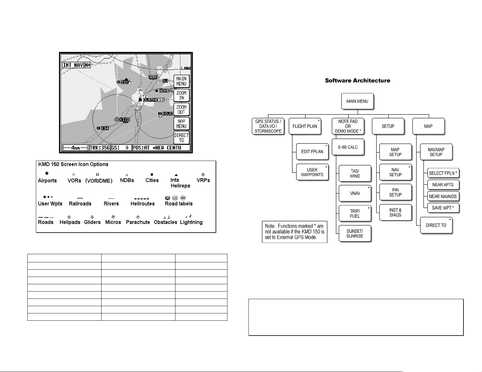
MENU STRUCTURE
All of the KMD 150 functions can be accessed by pressing the MAIN MENU
key and then selecting the desired function by pressing keys as shown on
the Menu structure diagram:
Terrain and Urban Areas Color Key
ATI Level AMR & PAI Level Color
Urban Areas Urban Areas Light Gray
less than 500 feet less than 1,000 feet Light Green
501 – 1,000 feet 1,001 – 2,000 feet Medium Green
1,001 – 2,000 feet 2,001 – 3,000 feet Dark Green
2,001 – 3,000 feet 3,001 – 5,000 feet Light Brown
3,001 – 5,000 feet 5,001 – 9,000 feet Medium Brown
5,001 – 9,000 feet 9,001 – 13,000 feet Dark Brown
greater than 9,001 feet greater than 13,001 feet White
006-18221-0000 006-18221-0000
Rev 1 Apr/06 Rev 1 Apr/06
MAP SETUP - Map orientation, measurement units, language, map
symbology and declutter settings, and other map settings.
NAV SETUP - CDI settings, leg sequencing, and alarm settings.
PIN SETUP Personal Identification Number security settings.
INST & DIAGS - Position logging settings, stormscope configuration,
external/internal GPS selection, GPS Status, output test.
Honeywell International Inc.
23500 West 105th Street
Olathe, KS 66061 USA
Tel: (913) 712-0400
Fax: (913) 791-1302
 Loading...