

Pioneer AVIC-5201NEX Operating Manual

AVIC-5201NEX
MULTIMEDIA NAVIGATION RECEIVER
English
Operation Manual
Notice to all users:
This software requires that the product is properly connected to your vehicle’ s
parking brake and depending on your vehicle, additional installation may be
required. For more information, please contact your Authorized Pioneer
Electronics retailer or call us at (800) 421-1404.
Be sure to read Important Information for the User first!
Important Information for the User includes the important information that you
must understand before using this product.

Contents
Thank you for buying this Pioneer product.
Please read through these instructions so you
will know how to operate your model properly.
After you have finished reading the instructions, keep this document in a safe place for
future reference.
Important
The screens shown in the examples may
differ from actual screens, which may be
changed without notice for performance and
function improvements.
■ Precaution ..........................4
Notes on internal memory ................................4
About this manual ............................................4
■ Basic operation ..................5
Checking part names and functions .................5
Remote control ................................................5
Protecting your product against theft ................5
Inserting/ejecting/connecting media.................5
On rst-time startup .........................................6
How to use the screens ....................................7
Supported AV source .......................................8
Displaying the AV operation screen ..................8
Selecting a source ...........................................8
Changing the display order of sources .............8
Using the touch panel ......................................8
■ How to use the Navigation
menu screen ......................9
Operating the Navigation menu screen ..........10
■ How to use the map .........11
How to read the map screen ..........................11
Operating the map screen ..............................11
Understanding the route guidance .................12
Browsing the data eld ...................................13
■ Searching for a
destination .......................13
How to plan your route ...................................13
Searching for a location by address ...............13
2
Searching for Points of Interest (POI) .............14
Selecting a destination from stored
locations ...................................................15
Selecting a destination from stored routes .....15
Selecting a location you searched for
recently .....................................................15
Searching for a location using “Combined
Search” .....................................................15
Searching for a location by the coordinates ....16
Searching for a location by scrolling the
map ...........................................................16
Using the “Map Location” screen ....................16
■ Checking and modifying
the current route ..............17
Modifying the route ........................................17
■ Registering and editing
locations and routes........19
Storing a location in “Saved Location” ............19
Storing a route in “Saved Routes” ..................19
Editing the stored route ..................................19
Deleting stored routes ....................................19
Saving a location as an alert point .................20
■Receivingreal-timetrafc
information .......................20
Displaying the “Trafc Summary” screen ........20
Viewing the trafc list .....................................20
Checking the trafc incidents on the map .......21
When trafc incidents occur on your route .....21
Turning the trafc information on or off ...........21
■ Checking useful
information about your
trip ....................................21
Displaying the “Useful Information” menu .......21
Recording your travel history ..........................22
Using the Trip Computer mode .......................22
Calculating the fuel consumption ...................22
■ Customizing preferences of
the navigation ..................23
Customizing the navigation settings ...............23
Information on each option of “Settings” .........24
Setting the alert point warnings ......................27
Getting the map update ..................................28
Expanding the use of the navigation
functions ...................................................28
Compatibility and connectivity ........................29
■ Bluetooth
Displaying the “Bluetooth” screen ...................30
Registering your Bluetooth devices ................30
Connecting a registered Bluetooth device
manually ...................................................30
Switching visibility ..........................................31
Entering the PIN code for Bluetooth wireless
connection ................................................31
Displaying the device information ...................31
Clearing the Bluetooth memory......................31
Updating Bluetooth software ..........................31
Displaying the Bluetooth software version ......31
®
connection ....30
■ Hands-free phoning .........31
Displaying the phone menu screen ................32
Making a phone call .......................................32
Receiving a phone call ...................................32
Minimizing the dial conrmation screen .........32
Changing the phone settings .........................32
Using the voice recognition function ...............33
Notes for hands-free phoning .........................33
■ Setup for iPod / iPhone or
smartphone ......................33
The basic ow of iPod / iPhone or smartphone
setup .........................................................33
Setting the device connection method............33
iPod / iPhone compatibility .............................34
™
device compatibility.........................34
Android
Information on the connections and functions
for each device ..........................................35
■ Radio ................................37
Starting procedure .........................................37
Storing the strongest broadcast
frequencies ...............................................37
Displaying the “Radio settings” screen ...........37
■ Disc ...................................38
Starting procedure .........................................39
Selecting les from the track name list ...........39
Switching the media le type ..........................39
Searching for the part you want to play ..........40
Operating the DVD menu ...............................40
Switching the subtitle/audio language ............40
Operating the DVD menu using touch panel
keys ..........................................................40
■Compressedles .............40
Starting procedure (for Disc) ..........................42
Starting procedure (for USB) ..........................42
Operations common to all le types ...............43
Audio le operations.......................................43
Video le operations ......................................43
Still image le operations ...............................43
■ iPod ..................................43
Connecting your iPod .....................................44
Starting procedure .........................................45
Selecting song or video sources from the
playlist screen ...........................................45
Using this product’s iPod function from your
iPod ...........................................................45
Selecting a song from the list related to the
song currently playing (link search) ...........45
Using Apple Music Radio ...............................45
■ AppRadio Mode ...............46
AppRadio Mode Compatibility ........................46
Using AppRadio Mode ...................................46
Starting procedure .........................................46
Using the keyboard (for iPhone users) ...........46
Using the audio mix function ..........................47
■ Apple CarPlay ..................47
Using Apple CarPlay ......................................47
Starting procedure .........................................47
Setting the driving position .............................48
Adjusting the volume ......................................48
■ Pandora
Using Pandora ...............................................49
Starting procedure .........................................49
Selecting a Pandora station from the list ........49
Adding a station .............................................50
®
..........................48
■ Bluetooth audio player ....50
Starting procedure .........................................50
Selecting les from the le name list ..............51
■ SiriusXM
Radio ................................51
SiriusXM tuner operations ..............................52
Starting procedure .........................................52
®
Satellite

Contents
Subscribing to the SiriusXM Satellite Radio
service ......................................................52
Selecting a channel from the category list ......52
Using TuneScan
Using TuneMix
Displaying the “SiriusXM Settings” screen ......53
Setting TuneStart
Setting parental lock ......................................53
Checking the update trafc and weather
information ................................................53
Using SportsFlash
Using the content alerts function ....................54
Selecting teams for Game Alert .....................54
Using Featured Favorites Band ......................54
Restoring the “SiriusXM Settings” to the
default .......................................................54
™
...........................................52
™
.............................................52
™
.........................................53
™
.......................................53
■ AUX source ......................55
Starting procedure .........................................55
Setting the video signal ..................................55
■ AV input ............................55
Starting procedure (for AV source) .................55
Starting procedure (for camera) .....................56
Setting the video signal ..................................56
■ MIXTRAX ..........................56
Using MIXTRAX .............................................57
Starting procedure .........................................57
Selecting an item from the list ........................57
Selecting songs not to be played ....................57
Displaying the “MIXTRAX Settings” screen ....57
■ iDatalink ...........................58
Using iDatalink ...............................................58
Starting procedure .........................................58
Using functions in Car Sources ......................58
Using functions in Car Features .....................58
Displaying obstacle detection information ......59
Displaying the setting screen for iDatalink ......59
■ System settings ...............59
Displaying the “System” setting screen ..........59
Setting the navigation information bar ............59
Setting navigation screen interruption ............59
Setting Bluetooth audio source activation ......59
Setting the ever scroll .....................................60
Setting the beep tone .....................................60
Setting the rear view camera ..........................60
Setting the second camera ............................61
Setting the camera for Camera View mode ....61
Setting the demo mode ..................................61
Selecting the system language ......................61
Setting the keyboard language with the
application for iPhone................................61
Adjusting the response positions of the touch
panel (touch panel calibration) ..................61
Setting the dimmer .........................................62
Adjusting the picture ......................................62
Displaying the rmware version .....................62
Displaying the open source licenses ..............63
Updating rmware ..........................................63
Checking sensor learning status and driving
status ........................................................63
Checking the connections of leads .................63
■ Audio adjustments ..........64
Displaying the “Audio” setting screen .............64
Using fader/balance adjustment .....................64
Switching sound muting/attenuation ..............64
Adjusting source levels ..................................64
Setting the rear speaker output ......................64
Setting the subwoofer output..........................64
Adjusting the cutoff frequency value ..............64
Selecting the listening position .......................64
Adjusting the speaker output levels nely .......65
Adjusting the time alignment ..........................65
Using the equalizer ........................................65
Adjusting the equalizer curve automatically
(Auto EQ) ..................................................65
■ Theme menu ....................67
Displaying the “Theme” setting screen ...........67
Selecting the wallpaper ..................................67
Setting the illumination color ..........................67
Selecting the theme color ...............................67
Selecting the style of the clock .......................67
Changing the preinstalled splash screen .......67
Replicating the settings ..................................68
■ Video settings ..................68
Setting up the video player .............................68
Setting the video signal for the rear view
camera ......................................................69
■ Favorite menu ..................70
Creating a shortcut ........................................70
Selecting a shortcut .......................................70
Removing a shortcut ......................................70
■ Other functions ................70
Setting the time and date ...............................70
Setting the “Sound Retriever” function ............70
Changing the wide screen mode ....................70
Storing song information to an iPod (iTunes
Tagging) ....................................................70
Selecting the video for the rear display ...........71
Setting the anti-theft function .........................71
Restoring this product to the default
settings .....................................................72
®
■ Appendix ..........................72
Troubleshooting .............................................72
Error messages .............................................73
Positioning technology ...................................76
Handling large errors .....................................77
Route setting information ...............................79
Handling and care of discs .............................80
Playable discs ................................................80
Detailed information for playable media .........80
Bluetooth .......................................................83
®
satellite radio .................................83
SiriusXM
WMA/WMV ....................................................83
FLAC ..............................................................83
DivX ...............................................................83
AAC ...............................................................84
Google, Google Play, Android
MIXTRAX .......................................................84
Detailed information regarding connected iPod
devices ......................................................84
Using app-based connected content ..............84
®
........................................................85
Pandora
MHL ...............................................................85
IVONA Text-to-Speech ...................................85
Notice regarding video viewing ......................85
Notice regarding DVD-Video viewing .............85
Notice regarding MP3 le usage ....................85
Notice regarding open source licenses ..........85
Map coverage ................................................85
Using the LCD screen correctly ......................85
Specications.................................................85
™
......................84
3
Precaution
Notes on internal memory
Before removing the vehicle battery
If the battery is disconnected or discharged, the memory will be
erased and must be reprogrammed.
Some of the settings and recorded contents will not be reset.
Data subject to erasure
The information is erased by disconnecting the yellow lead from
the battery (or removing the battery itself).
Some of the settings and recorded contents will not be reset.
Resetting the microprocessor
CAUTION
Pressing the RESET button resets settings and recorded
contents to the factory settings.
— Do not perform this operation when a device is connected
to this product.
— Some of the settings and recorded contents will not be
reset.
The microprocessor must be reset under the following
conditions:
Prior to using this product for the first time after installation.
If this product fails to operate properly.
If there appears to be problems with the operation of the
system.
If your vehicle position is shown on the map with a signifi-
cant positioning error.
1 Turn the ignition switch OFF.
2 Press the RESET button with a pen tip or other
pointed implement.
Refer to Checking part names and functions on page 5
Settings and recorded contents are reset to the factory settings.
About this manual
This manual uses diagrams of actual screens to describe operations. However, the screens on some products may not match
those shown in this manual depending on the model used.
Meanings of Symbols Used in This
Manual
This indicates to touch an appropriate soft key
on the touch screen.
HOLD
This indicates to touch and hold an appropriate soft key on the touch screen.
This indicates that there is a reference or
supplementary for the key or screen.
4
1
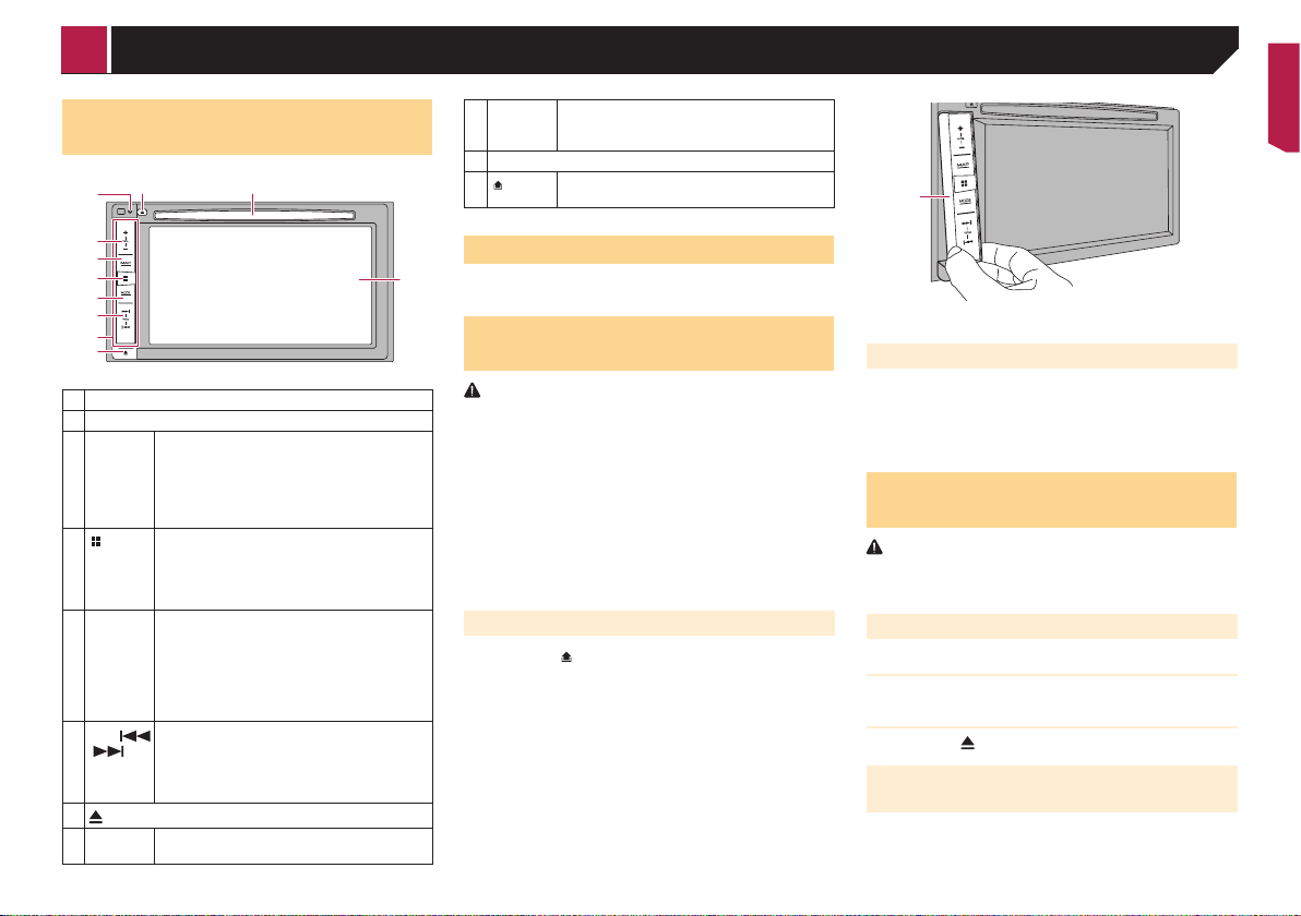
Basic operation
Checking part names and
functions
7
8
2
3
4
5
6
a
b
1 LCD screen
2 VOL (+/–) button
3 MAP
button
4
5 MODE
button
6
TRK (
/ )
button
7
8 RESET
button
Press to display the map screen.
Press and hold to switch to the camera view
mode.
p This function is available only when “ Back
Camera Input” or “2nd Camera Input” is
set to “On”.
Press to display the top menu screen.
button
Press and hold to activate the voice recognition function.
Refer to Using the voice recognition func-
tion on page 33
Press to switch between the Application
screen and the AV operation screen.
Press to turn the display off.
p Press and hold to turn the display off when
the Application screen is available.
p When the display is turned off, touch the
screen to revert to the original screen.
Press to return to the previous track (chapter)
or go to the next track (chapter).
Press and hold to perform fast reverse or fast
forward.
Press to answer or end a call.
button
Refer to Resetting the microprocessor on
page 4
9 Disc-
loading
slot
10 Detachable faceplate
9
11
Refer to Inserting and ejecting a disc on
page 5
Press to remove the detachable faceplate from
button
this product.
Remote control
The remote control CD-R33 (sold separately) is available.
1
For details, refer to the remote control manual.
Protecting your product against
theft
CAUTION
Do not expose the detachable faceplate to excessive shock
or disassemble it.
Never grip the buttons tightly or use force when removing
or attaching the detachable faceplate.
Keep the detachable faceplate out of reach of small
children to prevent them from placing it in their mouths.
After removing the detachable faceplate, keep it in a safe
place so it is not scratched or damaged.
Do not expose the detachable faceplate to direct sunlight
and high temperatures.
When removing or attaching the detachable faceplate, do
so after turning off the ignition switch (ACC OFF).
Removing the detachable faceplate
1 Press the button.
2 Gently grip the bottom of the detachable face-
plate and slowly pull it outward.
1 Detachable faceplate
Attaching the detachable faceplate
1 Slide the detachable faceplate all the way into
this product.
2 Push the lower part of the detachable faceplate
until you hear a click.
Inserting/ejecting/connecting
media
CAUTION
Do not insert anything other than a disc into the disc-loading
slot.
Inserting and ejecting a disc
Inserting a disc
1 Insert a disc into the disc-loading slot.
Ejecting a disc
1 Press the button.
Plugging and unplugging a USB storage device
p This product may not achieve optimum performance with
some USB storage devices.
p Connection via a USB hub is not possible.
p A USB cable is required for connection.
5
Basic operation
1 Pull out the plug from the USB port of the USB
cable.
2 Plug a USB storage device into the USB cable.
1
2
1 USB cable
2 USB storage device
p Check that no data is being accessed before pulling out the
USB storage device.
On rst-time startup
1 Start the engine to boot up the system.
The “Select Program Language” screen appears.
p From the second time on, the screen shown will differ
depending on the previous conditions.
p From the second time on, enter the password for the anti-
theft function if the password entry screen appears.
2 Touch the language.
3 Touch
The “Smartphone Setup” screen appears.
4 Touch the item.
Refer to Information on the connections and functions for
each device on page 35
5 Touch .
The warning message screen appears.
6 Touch [OK].
The top menu screen appears.
On rst-time startup of the navigation system
When you use the navigation function for the first time, an initial
setup process starts automatically. Follow the steps below.
p You can change the language later using [Regional] in the
“Settings” screen. Other settings can be restarted later
using [Start Conguration Wizard] in the “Settings”
screen.
1 Press the button.
6
.
2 Touch
or .
3 Touch the language that you want to use on the
navigation screen, then touch [Select].
4 Read the terms carefully, checking the details,
and then touch [Accept] if you agree to the
conditions.
5 Touch [Next].
6 Touch the language that you want to use for
voice guidance messages, then touch [Next].
7 If needed, modify the unit settings, then touch
[Next].
8 If needed, modify the default route planning
options, then touch [Next].
9 Touch [Activate], then [Next].
A message saying that the connected online features are activated appears if you activate these services right away.
Refer to “Connected Services” settings on page 27
10 Touch the connected services you want to use,
then touch [Next].
The initial setup is now complete. The map screen appears and
you can start using the navigation system.

Basic operation
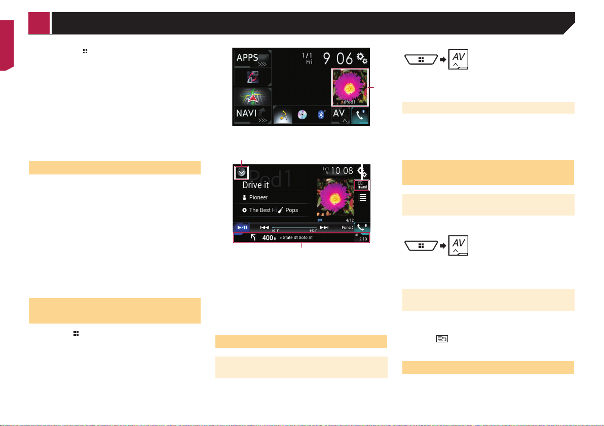
How to use the screens
Application menu screen
Application operation screen
Map screen
Navigation menu screen
Time and date setting screen Setting menu screen
Top menu screen
AV operation screen
Phone menu screen
Favorite source icons
AV source selection screen
7
12
Basic operation
p By pressing the
top menu screen.
p The character string “APPS” is replaced with “Apple
CarPlay” when Apple CarPlay is running.
p If you select “Power OFF” on the AV source selection screen,
you can turn off almost all functions. The “Power OFF” mode
is released in the following cases:
— An incoming call is received.
— The rear view camera image is input when the vehicle
reverses.
— A button on this product is pressed.
— The ignition switch is turned off (ACC OFF), then turned on
(ACC ON).
p To protect this product from damage, the cooling fan may
operate in “Power OFF” mode.
button on any screen you can display the
1 AV operation key
The AV operation screen appears.
Supported AV source
You can play or use the following sources with this product.
Radio (FM, AM)
CD
ROM (compressed audio or video files on discs)
DVD-Video
Video-CD
The following sources can be played back or used by connecting
an auxiliary device.
USB
iPod
Pandora
Bluetooth® audio
SiriusXM
AV input (AV)
AUX
Car Sources (iDataLink)
Displaying the AV operation
screen
1 Press the button.
2 Touch the AV operation key.
8
®
®
Satellite Radio
1 Displays the source list.
2 Recalls equalizer curves.
Refer to Using the equalizer on page 65
3 Shows the navigation information.
p This is not displayed for some sources.
p This is not displayed when “Navigation info window” is set
to “Off”.
Refer to Setting the navigation information bar on page
59
Selecting a source
Source on the AV source selection
screen
1 Display the AV source selection screen.
2 Touch the source icon.
1
p When you select “Source OFF”, the AV source is turned off.
Source on the source list
1 Display the source list.
Refer to Displaying the AV operation screen on page 8
2 Touch the source key.
p When you select “Source OFF”, the AV source is turned off.
Changing the display order of
sources
Changing the display order of source
icons
1 Display the AV source selection screen.
3
2 Touch and hold a source icon, and drag the icon
to the desired position.
Changing the display order of source
keys
1 Display the source list.
Refer to Displaying the AV operation screen on page 8
2 Touch .
3 Drag the source key to the desired position.
Using the touch panel
You can operate this product by touching the keys on the screen
directly with your fingers.
p To protect the LCD screen from damage, be sure to touch the
screen only with your finger gently.
Basic operation How to use the
Common touch panel keys
: Returns to the previous screen.
: Closes the screen.
Operating list screens
1
2
3
1 Touching an item on the list allows you to narrow down the
options and proceed to the next operation.
2 Appears when all characters are not displayed on the display
area.
If you touch the key, the rest are scrolled for display.
3 Appears when items cannot be displayed on a single page.
Drag the slider bar or the list to view any hidden items.
Operating the time bar
1
1 You can change the playback point by dragging the key.
p Playback time corresponding to the position of the key is
displayed while dragging the key.
p This function is not available for some media or sources.
Operating the on-screen keyboard
21
8
7
6
1 Displays the characters that are entered.
2 Moves the cursor to the right or left for a number of charac-
ters equivalent to the number of touches.
3 Enters the characters in the text box.
4 Deletes the input text to the left of the cursor one letter at a
time. Touching and holding the key deletes the letters to the
left of the cursor in rapid succession.
5 Confirms the entry and proceeds to the next step.
6 Enters a space.
7 Switches between alphabet and numbers/symbols.
8 Switches between capital and lower case letters.
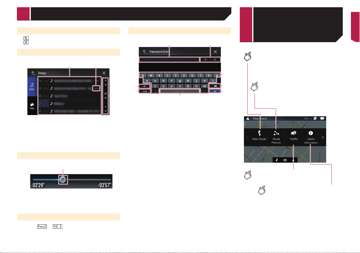
Navigation menu
screen
Searches for your destination by the
address or coordinates, or searches
for the selected place of interest, etc.
3
4
5
Builds your route or edits the
route currently set.
Main Menu 1
(without a planned route)
Displays the traffic screen.
Displays useful information to
support your driving.
Switching the operation panel
1 Touch or .
The hidden function keys appears.
p This key does not appear for some AV sources.
9
1 2
6
How to use the Navigation menu screen
Configures the navigation-related
settings.
You can also access the “SyncTool”
screen from this menu.
Main Menu 2
(without a planned route)
Displays information about your
navigation system.
The version information, or licenses
can be displayed, for example.
p The traffic features of [Trafc] can be used when the online
traffic feature is available.
Operating the Navigation menu
screen
1 Press the MAP button.
2 Touch
.
345
1 Returns to the map screen.
2 Displays notifications that contain important information.
3 Displays the location that you saved as a favorite.
4 Switches among 2D, 3D, and 2D North up view modes.
5 Displays the “User Proles” screen where you can create
new profiles or edit the existing profiles.
If multiple drivers are using this product, they can create
their own profiles with their own settings. If you select a new
profile, this product restarts so that the new settings can
take effect.
6 Displays the previous or next page of the navigation menu.
If there is no next or previous page, this item is grayed out.
on the upper right corner of the screen is used for
p
AVICSYNC App connection.
Be sure read Expanding the use of the navigation functions
(page 28) before using the AVICSYNC function.
When you are navigating a planned route, the following routerelated keys are available.
2 Displays route alternatives, parts of the route to avoid, or
specific roads in your planned route to avoid.
3 Suspends and resumes the route guidance.
4 Displays the route in its full length on the map, and displays
route parameters and route alternatives.
5 Deletes your route or removes a waypoint.
Other items
You will also see the following keys when you are navigating
without a planned route.
10
21345
1 Adds a waypoint.
5
4
2
3
6
9
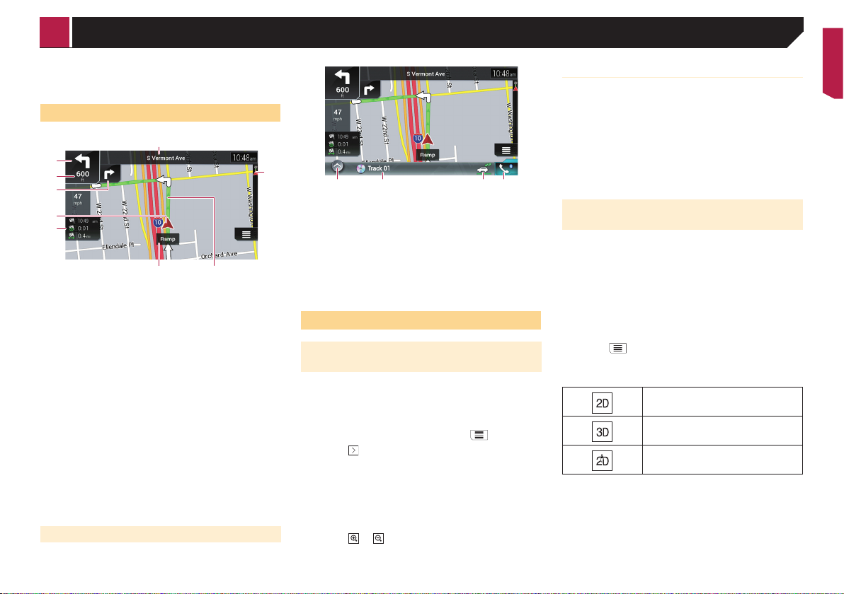
How to use the map
Most of the information provided by your navigation system
can be seen on the map. You need to become familiar with how
information appears on the map.
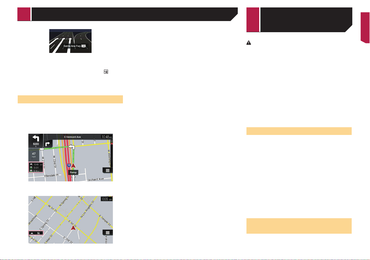
How to read the map screen
1
7
p The following information marked with an asterisk (*)
appears only when a route is set.
p Depending on the conditions and settings, some items may
not be displayed.
1 Shows the number and name of the street to be used (or
next guidance point).*
2 Shows the next guidance point (maneuver).*
The type of the event (turn, traffic circle, exiting freeway, etc.)
is displayed.
Refer to Frequently shown route events on page 12
3 Shows the distance to the next guidance point (maneuver).*
4 Shows the maneuver after the next maneuver.*
5 Indicates the current location of your vehicle. The apex of the
triangular mark indicates your orientation and the display
moves automatically as you drive.
p When there is no GPS position, the triangular mark is
transparent. It shows your last known position.
6 Displays the data field.
7 Shows the name of the street (or city) that your vehicle is
traveling on (or in).
8 Indicates the current route.*
The route currently set is highlighted in color on the map.
9 Indicates the progress to the final destination.*
AV information bar
AV information is displayed at the bottom of the map screen.
Smart Zoom
Your navigation system features “Smart Zoom” that works in
two ways:
When the route is set:
When approaching a turn, “Smart Zoom” will zoom in and
raise the view angle to enable you to easily recognize your
maneuver at the next junction. If the next turn is at a distance, it will zoom out and lower the view angle to be flat so
you can see the road in front of you.
When the route is not set:
“Smart Zoom” will zoom in if you drive slowly and zoom out
12 3 4
1 Touch to display the AV source list.
2 Shows the current status of AV source briefly.
3 You can turn on or off the communication between the
AVICSYNC App and the navigation system by touching the
key.
p This setting is always turned on when you use the
8
AVICSYNC App on an iPod / iPhone (the setting cannot
be changed).
4 Touch to display the phone menu screen.
Refer to Displaying the phone menu screen on page 32
Operating the map screen
Changing the scale of the map
manually
By default, even if the map scale is changed on the scrolled
map, it will return to the preset scale (according to the setting
in “Viewpoint”of the “Navigation Map” settings) when the
current position map is displayed. If you change the scale of the
current position map, perform the following procedure.
1 Press the MAP button and touch .
2 Touch
3 Touch [Navigation Map], and then [Map
Display].
4 Touch [Viewpoint].
5 Drag the pop-up window and touch [Manual].
6 Press the MAP button.
7 Touch
, and then touch [Settings].
or .
when you drive at high speed.
Switching between 2D, 3D, and 2D
North up views
You can switch how the map is displayed. For 2D map view
mode, you can select between “Heading up” and “North up”.
Heading up:
The map display always shows the vehicle’s direction as
proceeding toward the top of the screen.
North up:
The map display always has north at the top of the screen.
p The map orientation is fixed at “Heading up” when the 3D
map screen is displayed.
1 Press the MAP button.
2 Touch
3 Touch the following key.
Each time you touch the key the setting changes.
p There is a limit to map scaling in 3D map view mode. If the
map scale is zoomed out further, the map is zoomed out in
2D map.
.
Indicates 2D Heading up view mode is
currently selected.
Indicates 3D Heading up view mode is
currently selected.
Indicates 2D North up view mode is currently selected.
11
How to use the map
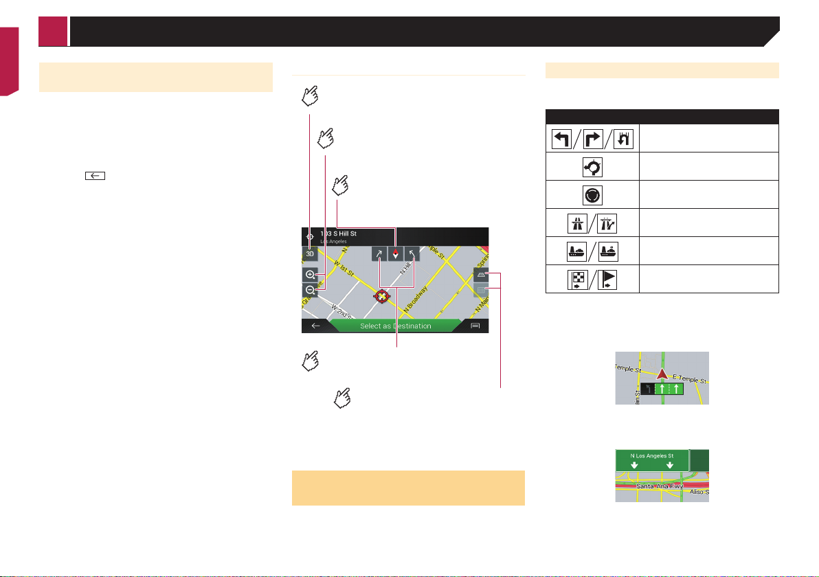
Scrolling the map to the position you
want to see
1 Press the MAP button.
2 Touch anywhere on the map or touch and drag
the map in the desired direction to scroll.
If you place the cursor on the desired location, a brief overview
about the location will appear at the top of the screen, showing
the street name and other information for the location.
3 Touch .
The map returns to the current position.
p If you press the MAP button, the map returns to the current
position.
Control keys on the scrolled map
Changes the map view mode.
The current map mode is shown on the
control key.
Zooms in or out on the map.
You can also zoom out or in by
pinching or expanding the map.
Cancels map rotation.
Map screen (scrolled map)
Rotates the map clockwise or
counterclockwise.
Tilts the map angle up or
down.
You can change the vertical view
angle of the map in 3D mode
only.
Frequently shown route events
The following are some examples of the maneuvers that are
displayed.
Icon Meaning
Turn left, turn right, turn back.
3
Lane information
When navigating on multilane roads, you will need to make sure
to take the proper lane for the recommended route.
Signposts
Signs are displayed at the top of the map.
Go left on the traffic circle, 3rd exit
(next maneuver).
Enter traffic circle (maneuver after
the next maneuver).
Freeway entrance or freeway exit.
Board ferry or leave ferry.
Approaching the destination or a
waypoint.
Understanding the route
guidance
Once the route guidance begins, the system provides various
guides by voice, text indications and signs.
12
Junction view
If you are approaching a complex intersection, the map is
replaced with a 3D view of the junction.
How to use the map Searching for a
p If the data for these items is not contained in the map data,
the information is not available even if there are signs on the
actual road.
When you set “Offer Freeway Services” to “on”, the
appears while you are driving on freeways. Touch the icon to
open the details of the next few exits or service stations. In addition, touch an item to show its location on the map. You can set
it as a waypoint easily.
icon
Browsing the data eld
The data fields are different when you are navigating a route and
when you have no specified destination. For example, the data
field provides the following information.
When the route is set:
Distance to final destination, time needed to reach the final
destination and estimated arrival time are shown.
When the route is not set:
Direction or altitude is shown.
p Touching and holding the field allows you to display the set-
ting screen for the field.
Refer to Data Fields on page 26
p The estimated time of arrival is an ideal value calculated
based on the speed limit value set in “Max. Speed” of
vehicle type setting and the actual driving speed. The esti-
mated time of arrival is only a reference value, and does not
guarantee arrival at that time.
Refer to “Route Preferences” settings on page 24
destination
CAUTION
For safety reasons, these route-setting functions are not
available while your vehicle is in motion. To enable these
functions, you must stop in a safe place and put on the
parking brake.
p Some information regarding traffic regulations depends on
the time when the route calculation is performed. Thus, the
information may not correspond with a certain traffic regulation when your vehicle actually passes through the location
in question. Also, the information on the traffic regulations
provided applies for a passenger vehicle, and not for a truck
or other delivery vehicles. Always follow the actual traffic
regulations when driving.
p [Destination from Phone] and [Online Search] on the
“New Route to...” screen can be used when the AVICSYNC
App connection is established.
Be sure read Expanding the use of the navigation functions
(page 28) before using the AVICSYNC function.
How to plan your route
The following is a summary of the route setting procedure.
1 Search for a destination using various methods
on the [New Route] menu.
The location you searched for appears on the “Map Location”
screen.
2 Touch [Select as Destination].
Refer to Using the “Map Location” screen on page 16
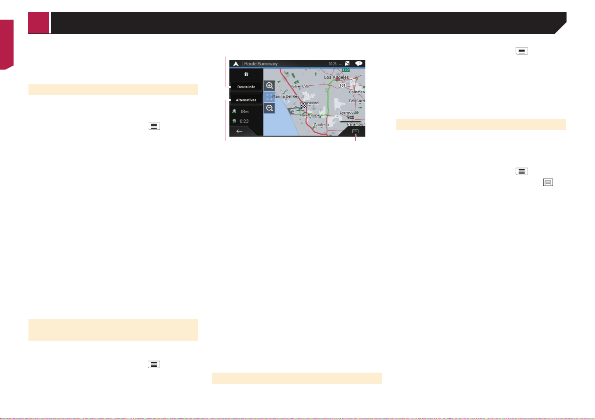
The “Route Summary” screen appears and countdown begins.
When the countdown ends, the guidance automatically starts.
If you touch the screen anywhere during the countdown, the
countdown stops and the screen will stay as it is.
Refer to Checking route information and preferences on page
18
3 Touch [Start Navigation].
Your navigation system starts the route guidance.
Refer to Understanding the route guidance on page 12
Searching for a location by
address
The most frequently used function is the address search in
which the address is specified and the location is searched.
13

Searching for a destination
p Depending on the search results, some steps may be
skipped.
1 Press the MAP button and touch .
2 Touch [New Route].
3 Touch [Address].
4 Touch the following text box and set the desti-
nation you are looking for.
Country:
By default, your navigation system proposes the country
where you are.
If you want to change the area to search set another country.
City or ZIP code:
By default, your navigation system proposes the city/town
where you are. You can select the city/town using its postal
code instead of its name.
Street:
If the street name is not available, touch [Go to City] and
select the city/town. This way the center of the selected city/
town becomes the destination of the route.
Select House Number or Intersection:
This item will be displayed after you have set a street. If the
house number is not available, touch [Go to Street] and
select the street. This way the center of the selected street
becomes the destination of the route.
After you touch the selected address to finish the address
search, the searched location appears on the map screen.
5 Touch [Select as Destination], and then touch
[Start Navigation].
Your navigation system starts the route guidance.
Searching for Points of Interest
(POI)
Information about various facilities (Points Of Interest – POI),
such as gas stations, parking lots or restaurants, is available.
You can search for a POI by selecting the category (or entering
the POI Name).
3 Touch [Places].
The preset search categories are as follows.
Gas Station
Accommodation
Restaurant
Parking
p When a route is not set, POIs are searched for around the
current position.
p When the current position is not available either (no GPS sig-
nal), POIs are searched for around the last known position.
p When a route is set, “Gas Station” and “Restaurant” are
searched for along the route, and “Accommodation” and
“Parking” are searched for around the destination.
4 Touch the category.
5 Touch the POI.
The searched location appears on the map screen.
If you touch , you can sort the results or show
the locations of all facilities on the map.
6 Touch [Select as Destination], and then touch
[Start Navigation].
Your navigation system starts the route guidance.
Searching for POIs by categories
or directly from the name of the
facilities
You can search for POIs by their categories and subcategories.
You can also search for POIs by their names in each of their
categories.
1 Press the MAP button and touch .
2 Touch [New Route].
3 Touch [Places].
4 Touch [Search Among All Places].
5 Touch [Around Here] and then select the area
in which the POIs should be searched for.
Category View:
You can select whether or not POI categories are displayed.
Around Here:
Searches around the current position. Or, around the last
known position if the current position is not available.
(The results will be listed in order of the distance from this
position.)
In a City:
Searches for a place within a selected city/town. (The results
will be listed in order of the distance from the center of the
selected city/town.)
Around Destination:
Searches for a place around the destination of the current
route. (The results will be listed in order of the distance from
the destination.)
p This key is active only when the route is set.
Along Route:
Searches along the current route, and not around a point
already set. This is useful when searching for a stopover
that results in a minimal detour, such as searching for gas
stations or restaurants. (The results will be listed in order of
the length of the necessary detour.)
p This key is active only when the route is set.
6 Select one of the categories, subcategories or
brands to narrow down the places.
If you touch [Search by Name], you can search for
POIs by their names.
7 Touch the POI.
The searched location appears on the map screen.
If you touch , you can change the sort method
of the results.
8 Touch [Select as Destination], and then touch
[Start Navigation].
Your navigation system starts the route guidance.
Searching for POIs using preset
categories
The preset search allows you to quickly find the most frequently
selected types of POIs.
1 Press the MAP button and touch .
2 Touch [New Route].
14
Searching for a destination
Searching for providers nearby that
offer emergency or roadside assistance services
Important
Never use this product to route to hospitals, police stations
or similar facilities in an emergency. Stop using any
functions relating to the hands-free phoning and please call
the appropriate emergency number.
You can search for locations that provide emergency or roadside
assistance in the surrounding areas.
p This information does not necessarily correspond to actual
information. Utilize the information for your reference.
1 Press the MAP button and touch .
2 Touch [Useful Information].
3 Touch [Help Nearby].
The preset search categories are as follows.
Car Repair
Health
Police
Gas Station
4 Touch the category.
5 Touch the POI.
The searched location appears on the map screen.
If you touch , you can change the sort method
of the results.
6 Touch [Select as Destination], and then touch
[Start Navigation].
Your navigation system starts the route guidance.
Selecting a destination from
stored locations
Storing locations you visit frequently saves time and effort.
Selecting an item from the list provides an easy way to specify
the position.
The list of saved locations contains two preset categories: Home
and Work.
p This function is available if locations have been registered in
“Saved Location”.
Refer to Storing a location in “Saved Location” on page
19
1 Press the MAP button and touch .
2 Touch [New Route].
3 Touch [Saved Location].
If you touch
details of saved locations.
4 Touch the entry.
The searched location appears on the map screen.
and then [Edit], you can edit the
5 Touch [Select as Destination], and then touch
[Start Navigation].
Your navigation system starts the route guidance.
Selecting a destination from
stored routes
Storing routes you use frequently saves time and effort.
p This function is not available if no routes have been regis-
tered in “Saved Routes”.
Refer to Storing a route in “Saved Routes” on page 19
1 Press the MAP button and touch .
2 Touch [New Route].
3 Touch
to show the next page.
4 Touch [Saved Routes].
5 Touch the entry.
p You can add waypoints or change the final destination on the
“Route Planner” screen.
Refer to Building a route using “Route Planner” on page
17
6 Touch [Show Route], and then touch [Start
Navigation].
Your navigation system starts the route guidance.
Selecting a location you
searched for recently
The places that were previously set as destinations or waypoints
have been automatically stored in “History”.
History
1 Press the MAP button and touch .
2 Touch [New Route].
3 Touch
to show the next page.
4 Touch [History].
5 Touch the entry.
The searched location appears on the map screen.
6 Touch [Select as Destination], and then touch
[Start Navigation].
Your navigation system starts the route guidance.
Smart History
Smart History suggests these previously used locations as destinations based on your navigation habits, using parameters like
the current time of day, the day of week, and the current location.
Smart History items are shown in the “New Route to...” screen
for easy access.
Searching for a location using
“Combined Search”
The “Combined Search” feature lets you quickly find a place by
its name and search area.
p The “Combined Search” function also searches your stored
data.
1 Press the MAP button and touch .
2 Touch [New Route].
3 Touch [Combined Search].
15
13 42
Searching for a destination
4 Touch the right text box to enter the country
and city/town.
5 Enter the name, address, or category of the
destination to the left text box, then touch
6 Touch the entry.
The searched location appears on the map screen.
7 Touch the right of the list to narrow down the
search results.
If you touch a map data provider logo, you can
narrow down the list of results by showing the
results from the provider.
8 Touch [Select as Destination], and then touch
[Start Navigation].
Your navigation system starts the route guidance.
Searching for a location by the
coordinates
Entering a latitude and longitude pinpoints the location.
1 Press the MAP button and touch .
2 Touch [New Route].
3 Touch
4 Touch [Coordinates].
5 Enter the latitude value and touch [OK].
p When a value is already entered in the text field, delete the
p You can change the display format of the latitude and
16
to show the next page.
value first.
longitude to any of the following formats: decimal degrees;
degrees and decimal minutes; or degrees, minutes and
decimal seconds.
When entering the coordinates in UTM format,
touch
6 Enter the longitude value and touch [Go!].
p When a value is already entered in the text field, delete the
value first.
The searched location appears on the map screen.
, then [UTM Coordinates].
7 Touch [Select as Destination], and then touch
[Start Navigation].
Your navigation system starts the route guidance.
Searching for a location by
scrolling the map
Specifying a location after scrolling the map enables you to set
.
the position as a destination or waypoint.
1 Press the MAP button.
2 Touch and drag the screen to scroll the map.
3 Touch the location that you want to select as
your destination.
The cursor appears.
4 Touch [Select as Destination], and then touch
[Start Navigation].
Your navigation system starts the route guidance.
Using the “Map Location”
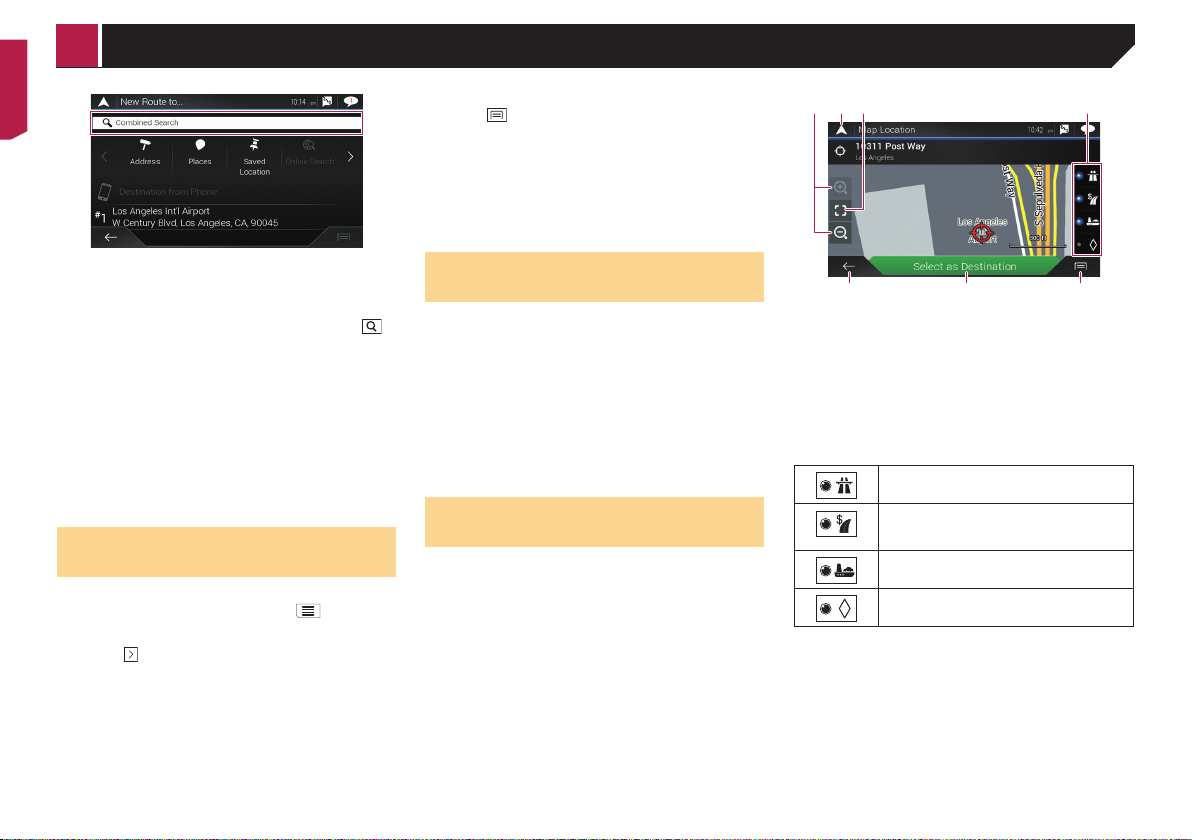
screen
Once a location is searched, the “Map Location” screen
appears. You can select some options for the route or displayed
map location before route calculation.
5 76
p If you touch the map, the cursor is placed at that position.
Also, you can scroll the map by dragging the map.
1 Zoom in/zoom out
p You can also pinch or expand the map to zoom in or out.
2 Cancels the “Map Location” screen and displays the map of
the current position.
3 Returns the cursor to the initial position and the map scale
to the initial scale.
4 Shows the route setting preferences for route calculation.
Touch the keys to activate or deactivate the preference.
Calculates the route prioritizing the use of
freeways when the key is activated.
Calculates the route prioritizing the use of
per-use charged toll roads when the key is
activated.
Calculates the route prioritizing the use of
ferries when the key is activated.
Calculates the route prioritizing the use of carpool and HOV lanes when the key is activated.
5 Returns to the previous screen.
6 Sets the cursor position to your destination (or waypoint).
7 Displays the shortcuts.
Detailed Information:
Shows the detailed information of the point.
Save Location:
Saves the displayed location as your favorite location. The
saved location can be easily recalled later.
Places Around Cursor:
Searches for POIs around the displayed location. Touch
the POI to show the “Map Location” screen, and also set
the POI as the destination (or waypoint).
21
34
Checking and modifying the current route
Modifying the route
When navigation is already started, there are several ways to
modify the current route. The following sections describe some
of those options.
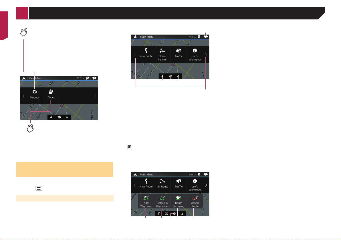
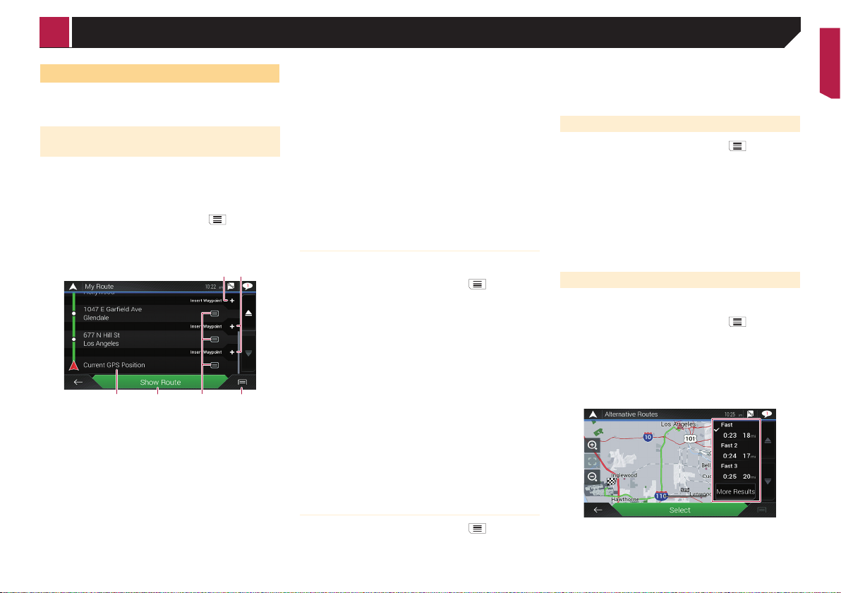
Building a route using “Route
Planner”
The “Route Planner” (or “My Route”) feature lets you build your
route using the list of destinations.
Editing the list allows you to plan your route easily.
p Once you set the route, you can edit your route using the
menu displayed as “My Route”.
1 Press the MAP button and touch .
2 Touch [Route Planner] or [My Route].
3 Touch one of the options.
56
1 Starting position (The current vehicle position is set as
default and [Current GPS Position] is displayed.)
Refer to Changing the starting position on page 17
2 Calculates the route and shows the “Route Summary”
screen.
3 Displays the options for the location.
Move Up/Move Down:
Edits the order you want to visit the locations.
Delete:
Deletes the destination or waypoint.
Save Location:
Stores the location in “Saved Location”.
Refer to Storing a location in “Saved Location” on page 19
Change:
Changes the destination or waypoint to another location.
Show on Map:
Shows the selected location on the map.
4 Displays the shortcuts.
Delete All:
Deletes all waypoints and the destination. Touch
[Continue Without Route] to cancel the planned route.
Optimize Waypoints:
Changes the order of waypoints automatically so that the
route can be easily traveled. (If the resulting order is the
same as the current order, this option is invalid.)
Optimize Route:
Changes the order of all waypoints and the destination
automatically so that the route can be easily traveled. (If
the resulting order is the same as the current order, this
option is invalid.)
5 Inserts a new waypoint.
6 Adds a new destination and changes the current destination
to the last waypoint.
Changing the starting position
The starting position for route can be changed from the current
position.
1 Press the MAP button and touch .
2 Touch [Route Planner] or [My Route].
3 Touch [Current GPS Position].
4 Touch [Set Start Point] or [Change Start Point]
and then touch [OK].
5 Search for a location.
6 Touch [Set Start Point] or [Change Start Point].
The selected position is set as the starting position for route
calculation.
7 Touch [Show Route] or [Continue Without
Route].
The system starts route recalculation after [Show Route] is
touched, and then the “Route Summary” screen appears. After
[Start Navigation] is touched, your navigation system starts the
route guidance.
After [Continue Without Route] is touched, the current position map appears.
Restoring the current position as the
starting position
1 Press the MAP button and touch .
2 Touch [Route Planner] or [My Route].
3 Touch [Current GPS Position].
4 Touch [Back to GPS Position] and then touch
[Delete Start Point].
The starting position for route calculation returns to the current
position.
Adding waypoints
1 Press the MAP button and touch .
2 Touch [Add Waypoint].
3 Search for a location.
4 Touch [Select as Waypoint].
The route is recalculated, and the “Route Summary” screen
appears. (When the waypoint is already set, the “My Route”
screen appears. Touch [Show Route] and proceed to the next
step.)
5 Touch [Start Navigation].
Your navigation system starts the route guidance.
Checking route alternatives
You can select another route and compare different route
alternatives.
1 Press the MAP button and touch .
2 Touch [Detours & Alternatives].
3 Touch [Alternative Routes].
4 Touch any of the route calculate conditions.
You can see the approximate time required and total distance of
selected route alternatives. Touch any of the route alternatives to
see it on the map.
p If more than three route alternatives have been found, [More
Results] appears. Touch [More Results] to show the other
routes.
17
3
Checking and modifying the current route
For information about route calculation conditions, refer
to Route Planning Method on page 24
5 Touch [Select].
The selected route is applied as your current route.
Checking detour routes
You can check for detour routes that avoid the selected sections
or streets, or that avoid the road ahead. You can also check for
alternative routes.
1 Press the MAP button and touch .
2 Touch [Detours & Alternatives].
3 Touch one of the options.
Alternative Routes:
Shows the alternative routes.
Refer to Checking route alternatives on page 17
Avoid Special Sections:
Shows the route avoiding certain sections. Touch the list
item to select the section you want to avoid. The distance
and time difference, suggested route, current route, and
the section avoided are shown. Touch [Accept] to apply the
suggested route.
Avoid Specic Road:
Shows the route avoiding certain road. Touch the list item to
select the road you want to avoid. Distance and time difference, suggested route, current route, section avoided are
shown. Touch [Accept] to apply the suggested route.
Avoid Road Ahead:
Shows the route avoiding the road ahead. Touch [+] or [–] to
set the distance you want to avoid. Touch [Avoid] to apply
the suggested route.
Restore Original Route:
Cancels the route with avoidances and restores the previous
route.
p The route set by [Alternative Routes] cannot be
canceled.
Checking route information and
preferences
Once you set the route, you can check a summary of the current
route.
1 Press the MAP button and touch .
2 Touch [Route Summary].
3 Touch one of the options.
18
1 2
The conditions of the displayed route is shown in the upper left
by icon. The total length of the route and approximate required
time for the route in the lower left.
p You can scroll the map by dragging the map.
1 Shows alternative routes.
Refer to Checking route alternatives on page 17
2 Displays the shortcuts.
Route Preferences:
Shows the route setting preferences. If you change the
preferences, the route is recalculated.
Itinerary:
Shows all transit points in detail. Touch a transit point to
show its position on the map. If you touch [Avoid] on the
map screen, the route is recalculated avoiding the transit
point (as much as possible).
Save Route:
Saves the displayed route. The saved route can be recalled
later.
Places Along Route:
Searches for POIs along the displayed route. Touch the
POI to show the “Map Location” screen, and also set the
POI as a waypoint.
Simulation:
You can run a simulation of the navigation for the current
route, as a demonstration.
Refer to Watching the simulation of the route on page 18
3 Shows the information for a transit point on the route.
Touching the items allows you to see the location on the
map. Touch [Avoid] and [Accept] to set the location as a
location to avoid.
Canceling the current route guidance
If you no longer need to travel to your destination, follow the
steps below to cancel the route guidance.
1 Press the MAP button and touch .
2 Touch [Cancel Route] or [Delete Waypoint].
3 Touch one of the options.
If there are no waypoints on the route, touch [Cancel Route] to
cancel the route.
If there are waypoints on the route, touch [Cancel Route] to
cancel the route. Touch [Delete Waypoint] to delete only the
nearest waypoint. In such case, the route is recalculated.
Watching the simulation of the route
You can run a simulation of the navigation for the current route,
as a demonstration.
1 Set a route to your destination.
Refer to Searching for a destination on page 13
2 Press the MAP button and touch .
3 Touch [Route Summary], and then touch
4 Touch [Simulation].
The simulation starts from the starting point of the route, and
using a realistic speed, it leads you through the whole recommended route.
Touch [Close] to stop the simulation.
.

Registering and editing locations and routes
Storing a location in “Saved
Location”
Storing your favorite locations in “Saved Location” allows you to
save the time and effort used on re-entering this information.
“Saved Location” can include your home location, workplace,
and places you have already registered.
Storing your home and your workplace location
You can store one home location and one workplace location.
1 Press the MAP button and touch .
2 Touch [New Route], and then [Saved Location].
You can also display the “Saved Location” screen by touching
on the bottom of the screen when the navigation menu is
displayed.
3 Touch [Home] or [Work] and then touch [OK].
p When you have already stored your home or workplace,
touch [Home] or [Work] to show the location on the “Map
Location” screen.
4 Search for a location.
Refer to Searching for a destination on page 13
5 Touch [Add to Saved Locations].
The cursor position has been stored.
Storing your favorite locations
You can store a frequently visited location (such as a relative’s
home) to allow easy routing.
1 Press the MAP button and touch .
2 Touch [New Route], and then [Saved Location].
You can also display the “Saved Location” screen by touching
on the bottom of the screen when the navigation menu is
displayed.
3 Touch [Add Location].
4 Search for a location.
Refer to Searching for a destination on page 13
5 Touch [Add to Saved Locations].
6 Enter the name if needed and then touch
The cursor position has been stored.
.
p In the on-screen keyboard, touching or enables you to
store the location as your home or workplace location.
Editing stored locations
Stored locations can be edited.
Switching to the edit mode
1 Press the MAP button and touch .
2 Touch [New Route], and then [Saved Location].
3 Touch
The “Select Location to Edit” screen appears.
, and then touch [Edit].
Renaming stored locations
1 Switch to the edit mode.
Refer to Switching to the edit mode on page 19
2 Touch the item you want to rename and touch
[Rename].
p “Home”and “Work” cannot be renamed. The location can be
set again.
3 Enter the name and then touch .
4 Touch [Done].
Deleting stored locations
1 Switch to the edit mode.
Refer to Switching to the edit mode on page 19
2 Touch the item you want to delete and touch
[Delete].
p “Home” and “Work” cannot be deleted. The location can be
set again.
p If you touch
(including the home and workplace locations) can be
deleted.
A message will appear asking you to confirm the deletion.
and then touch [Delete All], all entries
3 Touch [OK].
4 Touch [Done].
Storing a route in “Saved
Routes”
Storing your favorite routes in “Saved Routes” allows you to save
the time and effort used on re-entering this information.
1 Set a route to your destination.
Refer to Searching for a destination on page 13
2 Press the MAP button and touch .
3 Touch [Route Summary], and then touch
.
4 Touch [Save Route].
5 Enter the name if needed and then touch
.
Editing the stored route
Stored routes can be edited.
Renaming stored routes
1 Press the MAP button and touch .
2 Touch [New Route], and then
3 Touch [Saved Routes].
4 Touch
, and then touch [Edit].
5 Touch the item you want to rename and touch
[Rename].
6 Enter the name and then touch
7 Touch [Done].
.
.
Deleting stored routes
1 Press the MAP button and touch .
2 Touch [New Route], and then
3 Touch [Saved Routes].
4 Touch
, and then touch [Edit].
5 Touch the item you want to delete and touch
[Delete].
p If you touch and then touch [Delete All], all entries can
be deleted.
6 Touch [Delete].
.
19
Registering and editing locations and
Receiving real-
routes
Saving a location as an alert
point
Important
The warning for road safety cameras (like speed cameras) is
disabled when you are in certain countries where warnings
for road safety cameras are prohibited. However, you are
fully responsible for ensuring that this feature is legal in the
country where you intend to use it.
You can save any map location (such as a school zone or railroad
crossing) as an alert point.
p To use this function, activate the warnings beforehand and
set the alert types.
Refer to “Warnings” settings on page 25
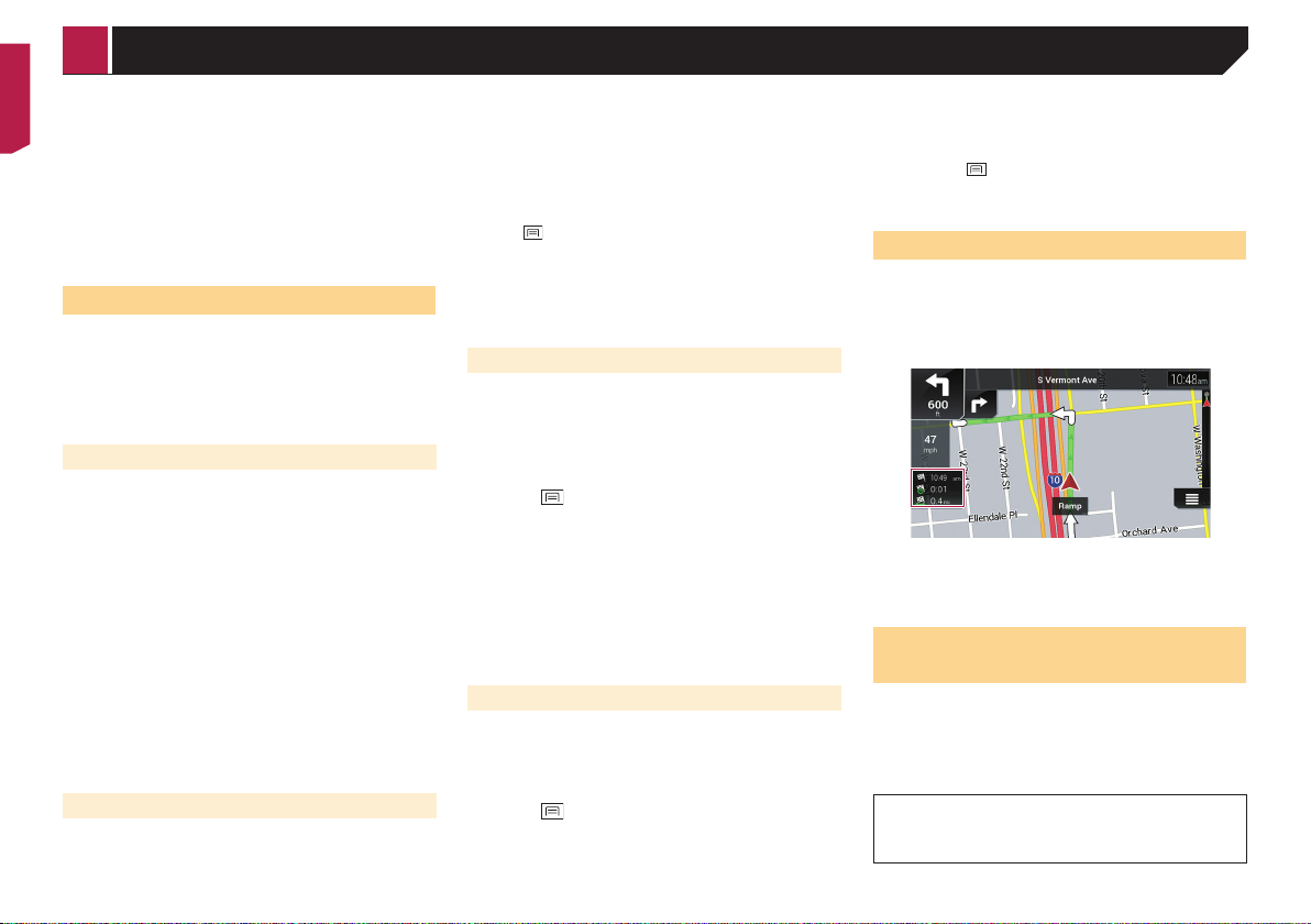
1 Press the MAP button.
2 Scroll the map and select a location.
The cursor appears at the selected point.
3 Touch .
4 Touch [Add Alert Points].
5 Set the necessary parameters.
Alert Type:
Sets the type of the alert point.
Speed Limit:
Sets the speed limit for this alert point (if applicable).
Direction:
Sets the direction from which you expect the alert to come
from.
6 Touch [Save].
Editing the stored alert points
Stored alert points can be edited.
1 Press the MAP button.
2 Scroll the map and move the cursor over the
stored alert point, and then touch
3 Touch [Edit Alert Points].
4 Set the necessary parameters.
If you touch
selected alert point will be deleted.
5 Touch [Edit].
and then touch [Delete], the
.
time trafc
information
p The online function in “Trafc” can be used if you connect
an iPhone or a smartphone that has the AVICSYNC App
installed.
Be sure read Expanding the use of the navigation functions
(page 28) before using the AVICSYNC function.
p The traffic information feature can be used when the online
traffic feature is available.
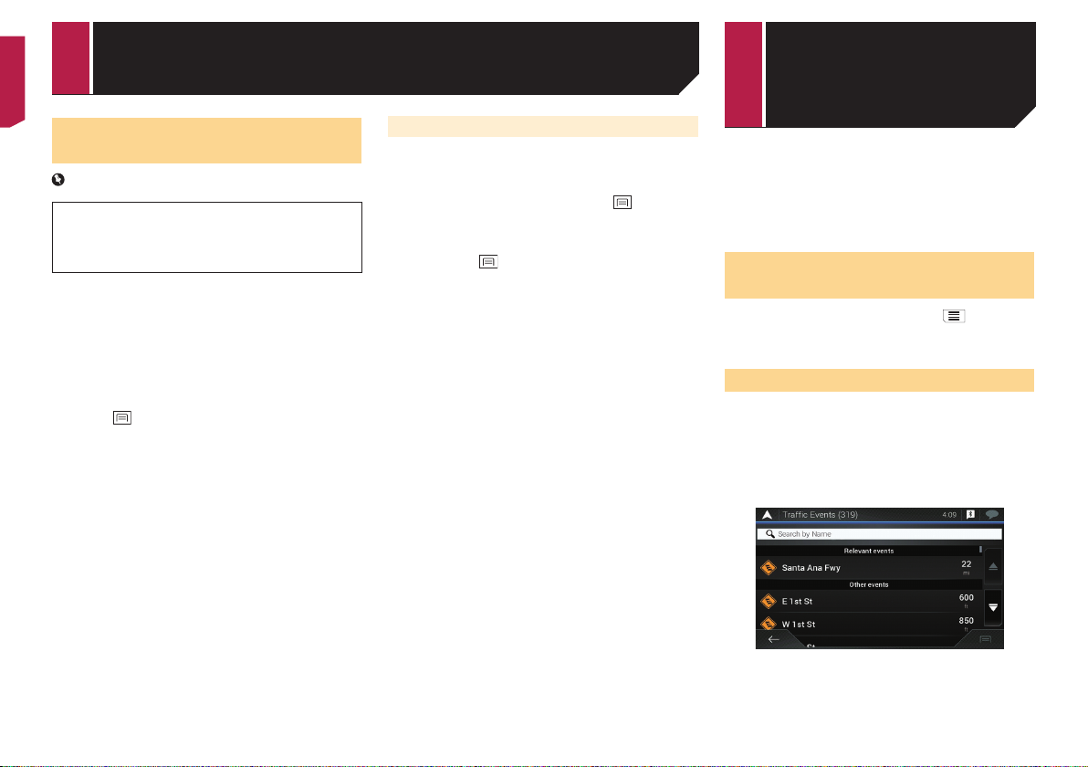
Displaying the “Trafc
Summary” screen
1 Press the MAP button and touch .
2 Touch [Trafc].
The “Trafc Summary” screen appears.
Viewing the trafc list
Traffic information is displayed onscreen in a list. This allows you
to check how many traffic incidents have occurred, the locations, and the distance from your current position.
1 Display the “Trafc Summary” screen.
Refer to Displaying the “Trafc Summary” screen on page
20
2 Touch [Trafc Events].
A list with traffic information that has been received is shown.
The list is sorted by distance from your current position. Places
(street names) where incidents have occurred are displayed on
the list.
p If a route is set, relevant events for your current route are
20
shown in the upper section of the list.
1
Receiving real-time trafc information Checking use-
p Touching the desired item allows you to check its position on
the map. Touch
or to show the previous or next event.
Checking the trafc incidents
on the map
Traffic event information can be displayed on the map.
1 Display the “Trafc Summary” screen.
Refer to Displaying the “Trafc Summary” screen on page
20
2 Touch [Trafc Map].
Road segments affected by traffic incidents are displayed in an
alternate color on the map, and small symbols above the road
show the nature of the incident.
The traffic congestion lines indicate the degree of the congestion
by color.
When trafc incidents occur on
your route
The notification icon shows the status of traffic information
reception.
1 Touch the relevant traffic event icon on the
map.
1 Traffic notification icon
Indicates that there are no traffic incidents in
your coverage area.
Indicates that information on traffic incidents
are being received.
Indicates that there are no significant traffic
incidents on your route.
Indicates that there are significant traffic
incidents on your route. The icon shows the
type of the next traffic incident.
You can check the details of the traffic incidents. Touch the
relevant event to display the location on the map.
Turning the trafc information
on or off
The traffic information feature is turned on by default. To enable
or disable the TMC feature, perform the following procedure.
p If you turn the traffic information feature off, [Trafc] on the
navigation menu disappears.
1 Press the MAP button and touch .
2 Touch
3 Touch
4 Touch [Trafc] to turn the switch on or off.
, and then touch [Settings].
, and then touch [Trafc].
ful information
about your trip
Displaying the “Useful
Information” menu
The “Useful Information” menu contains various information to
support your driving.
p To use the online functions (“Parking”, “Weather” and
“Fuel Prices”), the appropriate content installation must be
installed in the navigation system and a connection with
an iPhone or a smartphone that has the AVICSYNC App
installed must be established.
Be sure read Expanding the use of the navigation functions
(page 28) before using the AVICSYNC function.
1 Press the MAP button and touch .
2 Touch [Useful Information].
The “Useful Information” screen appears.
Information on each option in the “Useful
Information” menu
Parking:
Checks for parking lots near your current location.
Refer to the manual for AVICSYNC on our website
Fuel Prices:
Displays recent gas prices of gas stations near the current
location, along the current route, or in the town.
Refer to the manual for AVICSYNC on our website
Weather:
Checks the weather forecast for your current location, along
your route, around your destination, as well as for your saved
locations.
Refer to the manual for AVICSYNC on our website
Where Am I?:
Displays a special screen with information about the current
position and a key to search for nearby emergency or roadside assistance services.
p To save the current position as a “Saved Location” desti-
nation, touch
Refer to Storing a location in “Saved Location” on page 19
Help Nearby:
Checks for POIs in your surroundings.
The preset search categories are as follows.
— Car Repair:
— Health:
— Police:
— Gas Station:
.
21
Checking useful information about your trip
Trip Monitor:
Checks the statistical data of your trips (for example, start
time, end time, average speed, etc.).
Refer to Recording your travel history on page 22
GPS Information:
Displays the GPS information screen with satellite position
and signal strength information.
Fuel Consumption:
You can estimate the fuel cost to your destination by entering
the fuel consumption information in the navigation system.
Refer to Calculating the fuel consumption on page 22
Recording your travel history
Activating the trip logger enables you to record your driving
history (hereinafter called “trip log”). You can review your trip
log later.
p The trip logger is set so that it can be started manually by
default. You can change the settings of this function in order
to save the log automatically.
Refer to “Trip Monitor” settings on page 27
Activating trip logger temporarily
One-time activation is useful if you want to create a log only for
a particular trip.
1 Display the “Useful Information” menu.
Refer to Displaying the “Useful Information” menu on page
21
2 Touch [Trip Monitor].
A list of trip logs already recorded appears. A blank list appears if
you have not recorded any trip logs yet.
3 Touch [Start New Recording].
The trip logger is activated. The touch key changes to [Stop
Recording]. Touching [Stop Recording] allows you to deactivate
the trip logger.
p If there is not enough space in the built-in memory, the old-
est trip log will be overwritten by the new one.
p If you want the system to always activate the trip logger
whenever the GPS signal is available, turn on “Enable
Auto-Saving”.
Refer to Setting the trip logger on page 22
Browsing the trip log
1 Record the trip log.
2 Display the “Useful Information” menu.
22
Refer to Displaying the “Useful Information” menu on page
21
3 Touch [Trip Monitor].
p To export all trip logs, touch [Export All].
4 Touch any of the items to see the details.
p To display the trip log on the map, touch [Visible on Map] to
tick the check box.
Touching
use the following functions.
View on Map
Export Track Log:
allows you to view the shortcuts and enables you to
Shows the trip log on the map screen.
Exports the track log currently selected to a USB storage
device.
Setting the trip logger
1 Record the trip log.
2 Display the “Useful Information” menu.
Refer to Displaying the “Useful Information” menu on page
21
3 Touch [Trip Monitor].
4 Touch
Settings].
5 Touch any of the items to change the settings.
Enable Auto-Saving:
Sets whether automatic trip logging is activated or not.
Save Track Log:
Track logs, the sequence of the positions given by the GPS
receiver, can be saved together with trip logs. You can acti-
vate the track logger whenever the trip logger is activated.
p “Trip Database Size” indicates the current data size of the
and then touch [Trip Monitor
trip log (track log included).
Editing a trip log
1 Display the “Useful Information” menu.
Refer to Displaying the “Useful Information” menu on page
21
2 Touch [Trip Monitor].
3 Touch
4 Touch any of the items to edit.
Delete:
Deletes the trip log.
Rename:
and then touch [Edit].
Renames the trip log.
Change Color:
Changes the color by selecting another color from the color
table.
p If you touch
be deleted.
and then touch [Delete All], all entries can
5 Touch [Done].
Using the Trip Computer mode
In the trip computer screen, the information received from the
GPS receiver and your vehicle is displayed like a meter for a
vehicle.
1 Press the MAP button.
2 Touch the data field key.
p If you touch [Trip Summary], the details of the current trip
are displayed. Touch [Save Trip] to store the current trip log.
p If you press the MAP button, you can return to the map
screen.
Calculating the fuel
consumption
The fuel consumption monitor helps you keep track of the fuel
consumption of your car even if you do not use the navigation
system for all your journeys. Set the initial odometer value and
then record the distance driven and the amount of fuel whenever
you fill up your car. You can also set reminders for regular car
maintenance.
These calculations are based only on the information that
you provide and not on any data from the vehicle. The fuel
mileage displayed is only a reference value, and does not
guarantee that the fuel mileage displayed can be obtained.

Checking useful information about your
Customizing
trip
Setting the initial odometer value
Before you use the fuel consumption feature, enter the initial
odometer value from which you want to start measuring the
mileage.
1 Display the “Useful Information” menu.
Refer to Displaying the “Useful Information” menu on page
21
2 Touch [Fuel Consumption].
3 Touch [Initial Odometer Value].
4 Enter the initial odometer value and then touch
The initial odometer value has been set.
Entering the fuel consumption
information
To calculate the fuel consumption for the distance you have traveled, enter the distance driven and the amount of fuel whenever
you fill up your car.
1 Display the “Useful Information” menu.
Refer to Displaying the “Useful Information” menu on page
2 Touch [Fuel Consumption].
3 Touch [Add].
4 Touch [Current Odometer Value] and then
5 Touch [Gas Amount] to enter the amount of
6 Touch [Gas Price / Unit] to enter the fuel unit
7 Touch [Add].
8 Touch [Done].
p To delete an entry, touch to display the shortcut for
Setting the car maintenance schedule
1 Display the “Useful Information” menu.
.
21
enter the current odometer value.
fuel pumped this time.
price this time.
deletion.
Refer to Displaying the “Useful Information” menu on page
21
2 Touch [Fuel Consumption].
3 Touch
.
4 Touch [Maintenance Schedule].
5 Touch [Add] or the one of entries.
6 Enter the name, date, and mileage for the
reminder.
7 Touch [Done].
p To delete an entry, touch to display the shortcut for
deletion.
preferences of
the navigation
Customizing the navigation
settings
You can configure the navigation settings, and modify the
behavior of this system.
1 Press the MAP button and touch .
2 Touch
The “Settings” screen appears.
Route Preferences:
Sets the type of vehicle you are driving, the road types used
in route planning, and the route planning method.
Refer to “Route Preferences” settings on page 24
Sound:
Adjusts the different sound volumes and changes the voice
guidance profile.
Refer to “Sound” settings on page 25
Warnings:
Enables or disables warnings and sets up the warning
function.
Refer to “Warnings” settings on page 25
Navigation Map:
Fine-tunes the appearance of the map screen and adjusts
how the software helps you navigate with different kinds of
route-related information on the map screen.
Refer to “Navigation Map” settings on page 26
Regional:
Changes the voice guidance language, the application
language, and measurement units.
Refer to “Regional” settings on page 26
Display:
Sets separate themes for daytime and nighttime use,
adjusts the display backlight, and enables or disables menu
animations.
Refer to “Display” settings on page 27
Trafc:
Enables or disables the traffic information feature.
Refer to “Trafc” settings on page 27
Weather:
Enables or disables the online weather forecast option and
the automatic download of weather information.
Refer to the manual for AVICSYNC on our website
Fuel:
Enables or disables the online gas price option and sets up
the gas type.
, and then touch [Settings].
23

Customizing preferences of the navigation
Refer to the manual for AVICSYNC on our website
Trip Monitor:
Turns automatic trip log saving on or off and checks the current size of the trip database.
Refer to “Trip Monitor” settings on page 27
AVICSYNC
Displays the connection method for AVICSYNC.
p The setting value is fixed. Use this product as it is.
Connected Services:
Enables or disables the connected services.
Refer to “Connected Services” settings on page 27
Start Conguration Wizard:
Modifies the basic software parameters used during the
initial setup process.
SyncTool:
Starts the synchronization tool, which makes it possible to
update your maps.
Refer to Getting the map update on page 28
Restoring the default settings
You can restore settings or recorded content to the default
settings.
1 Press the MAP button and touch .
2 Touch
3 Touch
, and then touch [Settings].
.
4 Touch [Reset All Settings].
5 Touch [OK].
The recorded contents are cleared.
p If you touch [Factory Reset] on the shortcut, all data rel-
evant to navigation (including the items in saved locations
and histories) are deleted and all settings are reset to their
factory defaults.
Information on each option of
“Settings”
“Route Preferences” settings
Vehicle
You can set the type of vehicle you will be using on the route.
p The route is planned based on the selected vehicle type.
Route planning can also be configured to incorporate dimension, weight, and freight hazard restrictions for maps that
contain such data.
24
To enhance the route accuracy, correctly select a vehicle
type that is similar to the condition of your vehicle.
Car:
— Maneuver restrictions and directional constraints are
taken into account when planning a route.
— Roads are used only if access for cars is allowed.
— Private roads and resident-only roads are used only if they
are inevitable to reach the destination.
— Walkways are excluded from routes.
Emergency:
— All maneuvers available at intersections are taken into
account.
— Directional constraints are taken into account in the same
way as travel in the opposite direction is allowed at low
speeds.
— Only private roads that need to be used to access the
destination are included.
— Walkways are excluded from routes.
Bus:
— Maneuver restrictions and directional constraints are
taken into account when planning a route.
— Roads are used only if access for buses is allowed.
— Private roads, resident-only roads and walkways are
excluded from routes.
Taxi:
— Maneuver restrictions and directional constraints are
taken into account when planning a route.
— Roads are used only if access for taxis is allowed.
— Private roads, resident-only roads and walkways are
excluded from routes.
Truck:
— Maneuver restrictions and directional constraints are
taken into account when planning a route.
— Only roads that allow truck access are included.
— Private roads, resident-only roads and walkways are
excluded from routes.
— U-turns are not used in routes (turning around on a
divided road is not considered a U-turn for the purpose of
this system).
p To edit the name and estimated maximum speed of the
selected vehicle profile, touch
p To add a new vehicle profile, touch [Add Prole]. Then select
one of the vehicle types and set the name and estimated
maximum speed.
Route Planning Method
You can change the route planning method. Route calculation
can be optimized for different situations and vehicle types by
changing the planning method. The route planning method
types are as follows.
Fast
.
Calculates a route with the shortest travel time to your
destination as a priority. Usually the best selection for fast
and standard cars.
Easy
Results in a route with fewer turns and no difficult maneuvers. With this option, you can make this system to take, for
example, the freeway instead of a series of smaller roads or
streets.
Short
Calculates a route with the shortest distance to your destination as a priority. Usually practical for slower vehicles. Rarely
practical to use to search for shorter routes for normal
vehicles regardless of the speed.
Economical
Calculates a route that is quick and saves fuel.
Navigation Mode
You can enable or disable off-road navigation.
On-road
The route is planned towards the destination along the roads
on the map.
Off-road
The route is planned towards the destination in a straight
line, not along the roads on the map.
Highways
When this function is turned off, the route is calculated prioritizing the avoidance of freeways.
This function is useful when you want to avoid freeways when
you are driving a slow car or you are towing another vehicle.
Period Charge
When this function is turned off, the route is calculated prioritizing the avoidance of toll roads.
This function is useful when you want to avoid toll roads with
restricted time access that require you to purchase a separate
pass or vignette to extend the length of time allotted for use.
p This option can be enabled or disabled separately from the
pre-use toll road usage option.
Per-use Toll
When this function is turned off, the route is calculated prioritizing the avoidance of per-use charged toll roads.
This function is useful when you want to avoid toll roads where
there is a per-use charge.
Ferries
When this function is turned off, the route is calculated prioritizing the avoidance of ferries.

Customizing preferences of the navigation
Car Shuttle Trains
When this function is turned off, the route is calculated prioritising the avoidance of car shuttle trains.
Car shuttle trains are used to transport vehicles for relatively
short distances and they usually connect places that are not
easily accessible by road.
Carpool Lanes
When this function is turned off, the route is calculated prioritizing the avoidance of carpool and HOV lanes.
p The navigation system avoids carpool and HOV lanes by
default.
Unpaved Roads
When this function is turned off, the route is calculated prioritizing the avoidance of unpaved roads.
p The navigation system avoids unpaved roads by default.
“Sound” settings
p The following settings marked with an asterisk (*) are
enabled only when a TTS-voice is selected for the voice
language.
Voice
You can adjust the volume of the guidance sounds (verbal
instructions).
Alert Beeps
You can adjust the volume of the non-verbal alert sounds
(beeps).
Ding
You can turn off the attention tone that precedes the verbal
instructions or adjust its volume.
Voice Guidance
You can enable or disable voice guidance.
p This function is enabled by default.
Announce Streets and Roads in Native
Language Area*
You can select whether to have the navigation system announce
the street names in the native language of the area, only the road
numbers, or only the maneuvers.
Announce Streets and Roads in
Foreign Language Area*
You can select whether to have the navigation system read the
street names in a foreign country, only the road numbers, or only
the maneuvers.
Early Indication of Maneuvers
You can select whether you want an immediate announcement
for the next maneuver or to receive the information when the
maneuver is near.
Verbosity Level
You can set the verbosity of the voice instructions: how much
information is given and how often the prompts occur.
Minimal: Voice instructions are given once right before the
next maneuver.
Medium: Voice instructions are given once as the vehicle
approaches the next maneuver and it is repeated right before
the maneuver.
Verbose: Voice instructions are given once relatively far from
the next maneuver, it is repeated as the vehicle approaches
the next maneuver, and it is repeated again right before the
actual maneuver.
Announce Route Summary*
You can select whether to have the navigation system announce
by voice a quick summary of the route whenever a route is
calculated.
Announce Country Info*
When you cross country borders, this navigation system can
read out information about the country you have just entered.
p This function is not effective if the map coverage of your
navigation system is only one country (technically, there is
no country border data).
Announce Trafc Info*
You can select whether to have the navigation system announce
by voice the traffic information whenever a traffic incident on
your route is received.
Announce System Messages*
When a system message appears, this navigation system can
read out the message.
“Warnings” settings
Important
This system is able to warn you if you exceed the current
speed limit. This information may not be available for
your region (ask your local dealer), or may not be fully
correct for all roads on the map.
You are liable for ensuring that using this feature is legal
in the country where you intend to use it.
Speed Warning
Warn When Speeding
You can select whether you want to receive visible and/or
audible warnings.
The following alert types are available:
— Audio and Visual: When selected, audible and visible
warnings will go off when you exceed the speed limit.
— Visual: When selected, visible warnings will go off when
you exceed the speed limit.
— Disabled: When selected, no warnings will go off.
Speed Limit Always Visible
You can select whether you want to see the speed limit sign
on the map all the time. When you set the speed limit to
always be visible, the color of the speed limit sign changes
when you exceed the speed limit.
Outside Cities: ***% of the Speed Limit
You can receive a warning when you reach the set percentage of the speed limit in rural areas.
Within Cities: ***% of the Speed Limit
You can receive a warning when you reach the set percentage of the speed limit in urban areas.
Alert Points
This setting allows you to receive a warning when approaching
alert points like school zones or railroad crossings.
Refer to Setting the alert point warnings on page 27
Warning Road Signs
Maps may contain driver alert information. Touch this key to turn
on or off these warnings and to set the distance from the hazard
to receive the warning at. These can be set individually for the
different warning types.
25

Customizing preferences of the navigation
“Navigation Map” settings
Map Display
You can see the effect when you change a setting.
Viewpoint
You can adjust the basic zoom and tilt levels to your needs.
Some preset levels are available. If you select “Manual”, you
can store adjusted map scales and view angles.
Color Mode
You can switch between daytime and nighttime color modes
or let the software switch between the two modes automatically a few minutes before sunrise and a few minutes after
sunset.
Day Map Color
You can select the color scheme used in the daytime map.
Night Map Color
You can select the color scheme used in nighttime map.
Landmarks
This setting shows or hides 3D landmarks which are 3D
artistic or block representations of prominent or well-known
objects.
p This function becomes effective only when the additional
map data is installed.
Buildings
This setting shows or hides 3D city models which are 3D
artistic or block representations of complete city building
data containing actual building sizes and actual positions
on the map.
p This function becomes effective only when the additional
map data is installed.
3D Terrain
This setting shows or hides the 3D elevation of the surrounding terrain.
Track Logs
You can turn on or off track log saving which saves the
sequence of the locations you go through on your journeys.
Place Markers
You can select which POI icons to show on the map while
navigating.
p When a large number of POI icons exist on a map display,
maps and POI icons become hard to see. To maintain
map and POI visibility, reduce the displayed categories as
much as possible.
Data Fields
You can choose to have different values displayed for when navigating a route to a select destination and for when just cruising
around without any particular destination.
Refer to Browsing the data field on page 13
26
“First”, “Second” and “Third” selects items displayed in the data
fields shown when the route exists. “Without Route” selects
the items displayed in the data fields shown when a route does
not exist.
Route Progress Bar
You can turn on the route progress bar to display the current
route as a straight line located on the right side of the map. The
arrow represents your current position and moves up the line as
you travel along the route.
Offer Freeway Services
You may need to stop by a gas station or a restaurant during
your journey.
Refer to Frequently shown route events on page 12
Services Displayed
You can select the service types displayed for the freeway exits or
service stations. Choose from the POI categories.
Automatic Overview
When selected, the map zooms out to show an overview of the
surrounding area if the next route event (maneuver) is far. When
you get close to the event, the map returns to the normal map
view.
Signposts
Whenever adequate information is available, lane information
similar to the real ones on road signs above the road is displayed
at the top of the map. You can turn this feature on or off.
Junction View
If you are approaching a freeway exit or a complex intersection
and the necessary information is available, the map is replaced
with a 3D view of the junction.
Tunnel View
When entering tunnels, the surface roads and buildings can
be distracting. This feature shows a generic picture of a tunnel instead of the map. A top-down overview of the tunnel and
remaining distance are also displayed.
Offer Congestion Detour on Highways
When you slow down while driving on a freeway due to a traffic
congestion, this navigation system offers you a detour using the
next exit. The message shows you the distance to the exit and the
difference in the distance and estimated time compared to the
original route. You can choose from one of the following options:
Touch [Dismiss] or just ignore the message if you want to
keep the original route.
Touch [Preview] to see an overview of the original route and
the detour to make the decision. You can accept the detour
as shown in the preview, or increase the freeway segment
bypassed before accepting.
Turn to the suggested new direction and the route will be
automatically recalculated.
Offer Real Time Alternative Routes
Alternative routes can be suggested when driving on normal
roads. This navigation system will select a different turn in the
upcoming intersection and offer you a different route for the next
section of the route. You cannot, however, modify the offered
detour.
Offer Parking Around Destination
Parking at the destination may not be easy to find in city areas.
As you approach the destination, this navigation system can
offer parking category places near your destination. Touch
to open a top-down map with the destination and the offered
parking places. The route is calculated by selecting one of the
parking places.
Offer Hints Upon Detour
If you leave the recommended route and suddenly exit the
freeway, this navigation system offers different alternatives near
the exit like gas stations or restaurants. Also, if there are avoidable parts of the original route ahead (like a tunnel, a toll road or
a ferry), you will find them in the list in case you want to bypass
them with the help of this navigation system.
“Regional” settings
Language
This key displays the current language of the user interface. By
touching the key, you can select a new language from the list of
available languages. This system will restart if you change this
setting.
Voice Language
This key displays the current voice guidance profile. By touching
the key, you can select a new voice guidance language from the
list of available languages and speakers. Touch any of these keys
to hear a sample voice prompt.
Units and Formats
You can set the various units to be used by this system.
Customizing preferences of the navigation
p This system may not support all the listed units in some
voice guidance languages.
Distance
The unit of distance can be changed.
Fuel Economy
The unit of fuel mileage can be changed.
Weight
The unit of weight can be changed.
Temperature
The unit of temperature can be changed.
Coordinate Display Format
The format of the coordinates can be changed.
Currency
The currency unit can be set.
Time Zone
By default, the time zone is taken from the map information and
adjusted according to your current location.
Automatic Time Zone
The time zone setting changes automatically.
Manual Time Zone
The present setting value for the time difference and daylight
saving time that you set are used.
Manual Time Zone if Auto Unavailable
The time zone setting changes automatically if automatic
change is available. Otherwise, the present setting value that
you set is used.
Manual Time Zone in Current Zone
The present setting value that you set are used in the current
time zone. If your vehicle moves to another time zone, the
time zone setting changes automatically.
p If a setting other than “Automatic Time Zone” is selected,
“Time Zone” (the option to set the time difference manually)
and “Daylight Saving Time” (the option to turn on or off
daylight saving time) can also be set.
“Display” settings
Menu Animations
When animation is turned on, the keys on the menus and keyboard screens appear in an animated way. Screen transitions
are also animated.
Day Skin Theme
You can select the style and colors of the navigation menu used
in the daytime.
Night Skin Theme
You can select the style and colors of the navigation menu used
in the nighttime.
“Trafc” settings
Trafc
You can set to enable or disable the TMC receiver that can
receive real-time traffic information.
Data Source
You can select what data source you want to use for receiving
real-time traffic information. [Online] is available only if the
device is enabled.
Use Trafc Info
You can select whether to have traffic incidents be taken into
consideration when the route is calculated.
Show Trafc Info
You can select whether to show icons relevant to traffic incidents
and lines indicating the traffic flow on the map.
Off
No traffic icons or lines indicating the traffic flow are shown.
Color
Only the line relevant traffic incidents are shown on the map.
Color And Icon
Icons for the relevant traffic incidents and lines indicating
the traffic flow are shown on the map.
Show Free Trafc Flow As Well
You can select whether to receive information on smooth traffic
flow.
Offer Detour if it Saves at Least
You can set the minimum time to be saved when having the
system suggest a detour route. If the estimated time saved by the
planned detour avoiding the traffic incidents is more than the set
time, the system suggests the new detour route. Otherwise, the
new route is not suggested.
Conrm Detours Manually
You can enable or disable the manual confirmation of every
recalculation.
“Trip Monitor” settings
Enable Auto-Saving
Refer to Setting the trip logger on page 22
Save Track Log
Refer to Setting the trip logger on page 22
“Connected Services” settings
You can use the “Connected Services” settings to enable or
disable connected online features.
Refer to Expanding the use of the navigation functions on
page 28
Online Trafc
You can enable or disable the online traffic service.
Online Weather
You can enable or disable the online weather forecast service.
Online Parking
You can enable or disable the online parking service.
Online Fuel Prices
You can enable or disable the online gas price service.
Online Search
You can enable or disable the online search service.
Setting the alert point
warnings
Important
The warning for road safety cameras (like speed cameras) is
disabled when you are in certain countries where warnings
for road safety cameras are prohibited. However, you are
fully responsible for ensuring that this feature is legal in the
country where you intend to use it.
You can set an alert for the different alert point categories,
individually.
1 Press the MAP button and touch .
2 Touch
, and then touch [Settings].
27
 Loading...