

Page 1
Operation Manual
MULTIMEDIA NAVIGATION RECEIVER
AVIC-8100NEX
AVIC-7100NEX
AVIC-6100NEX
AVIC-5100NEX
Notice to all users:
This software requires that the product is properly
connected to your vehicle’s parking brake and
depending on your vehicle, additional installation may
be required. For more information, please contact your
Authorized Pioneer Electronics retailer or call us at
(800) 421-1404.
Be sure to read Important Information for the User
first!
Important Information for the User includes the
important information that you must understand before
using this product.
English
Page 2
Contents
Thank you for buying this Pioneer product.
Please read through these instructions so you will know how to operate your model
properly. After you have finished reading the instructions, k eep this document in a
safe place for future reference.
Important
The screens shown in the examples may differ
from actual screens, which may be changed
without notice for performance and function
improvements.
Introduction
Manual overview 11
– How to use this manual 11
– Conventions used in this manual 11
– Terms used in this manual 11
Notes on internal memory 12
– Before removing the vehicle
battery 12
– Data subject to erasure 12
– Resetting the microprocessor 12
Basic operation
Checking part names and functions 13
Remote control 14
Use and care of the remote control 15
– Installing the battery 15
– Using the remote control 15
Protecting your product against theft 16
– Removing the detachable
faceplate 16
– Attaching the detachable faceplate 16
Notes on using the LCD panel 16
Adjusting the LCD panel angle 17
Inserting/ejecting/connecting media 17
– Inserting and ejecting a disc 17
– Inserting and ejecting an SD memory
card 18
– Connecting and disconnecting an
iPod 19
– Plugging and unplugging a USB
storage device 19
Startup and termination 19
On first-time startup 19
Regular startup 20
– A message about the map
database 20
Turning off the display 20
– When the Application screen is
available 20
– When the Application screen is not
available 20
How to use the screens 22
– Switching screens using the touch
panel keys 22
– Switching screens using the hardware
buttons 23
Supported AV source 24
Displaying the AV operation screen 24
– Selecting a front source on the AV
source selection screen 25
– Selecting a front source on the source
list 25
– Selecting a rear source 25
Turning off the AV source 25
Changing the display order of source
icons 25
Changing the display order of source
keys 26
Using the touch panel 26
– Using the common touch panel
keys 26
– Operating list screens 27
– Operating the time bar 27
– Operating the on-screen keyboard 27
On first-time startup of the navigation
system 28
How to use the Navigation menu screen
Operating the Navigation menu screen 29
How to use the map
How to read the Map screen 31
AV information bar 31
Operating the Map screen 32
– Changing the scale of the map 32
2
En
Page 3

Contents
– Smart Zoom 32
– Switching between 2D, 3D, and 2D
North up views 32
– Scrolling the map to the position you
want to see 33
– Control keys on the scrolled map 33
Understanding the route guidance 34
– Frequently shown route events 34
Browsing the data field 35
– When the system cannot receive a GPS
signal 35
Searching for a destination
Searching for a location by address 37
Searching for Points of Interest (POI) 38
– Searching for POIs using preset
categories 38
– Searching for POIs by categories or
directly from the name of the
facilities 39
– Searching for providers nearby that
offer emergency or roadside assistance
services 40
Selecting a destination from stored
locations 41
Selecting a destination from stored
routes 41
Selecting a location you searched for
recently 42
– History 42
– Smart History 42
Searching for a location using “Combined
Search” 43
Searching for a location by the
coordinates 44
Searching for a location by scrolling the
map 44
Using the “Map Location” screen 45
Checking and modifying the current
route
Modifying the route 46
– Building a route using “Route
Planner” 46
– Adding waypoints 47
– Checking route alternatives 47
– Checking detour routes 48
– Checking route information and
preferences 48
– Canceling the current route
guidance 49
– Watching the simulation of the
route 50
Registering and editing locations and
routes
Storing a location in “Saved Location” 51
– Storing your home and your workplace
location 51
– Storing your favorite locations 51
– Editing stored locations 51
Storing a route in “Saved Routes” 52
Editing the stored route 53
– Renaming stored routes 53
– Deleting stored routes 53
Saving a location as an alert point 53
Editing the stored alert points 54
Receiving real-time traffic information
(TMC)
Viewing the traffic list 55
Checking the traffic incidents on the
map 55
When traffic incidents occur on your
route 56
Turning the traffic information on or off 56
Checking useful information about your
trip
Checking useful information 57
Recording your travel history 58
– Activating trip logger temporarily 58
– Browsing the trip log 58
– Setting the trip logger 59
En
3
Page 4

Contents
– Editing a trip log 59
Using the Trip Computer mode 59
Calculating the fuel consumption 60
– Setting the initial odometer value 60
– Entering the fuel consumption
information 60
– Setting the car maintenance
schedule 61
Customizing preferences of the
navigation
Customizing the navigation settings 62
– Restoring the default settings 63
Information on each option of “Settings” 63
–“Route Preferences” settings 63
–“Sound” settings 65
–“Warnings” settings 66
–“Navigation Map” settings 66
–“Regional” settings 68
–“Display” settings 69
–“Traffic” settings 69
–“Weather” settings 69
–“Fuel” settings 69
–“Trip Monitor ” settings 69
–“Online Services” settings 69
–“Usage Reports” settings 70
Setting the alert point warnings 70
Expanding the use of the navigation
functions 71
– Be sure to read before you use
AVICSYNC function 71
– What is the AVICSYNC App? 72
Compatibility and connectivity 72
– AVICSYNC compatibility 72
– Preparations before using the
AVICSYNC function 73
Getting the map update 73
Registering and connecting a Bluetooth
device
Preparing communication devices 74
Registering your Bluetooth devices 74
– Searching for nearby Bluetooth
devices 74
– Pairing from your Bluetooth
devices 75
– Connecting to a Bluetooth device
automatically 76
– Deleting a registered device 76
Connecting a registered Bluetooth device
manually 77
Switching visibility 77
Entering the PIN code for Bluetooth wireless
connection 77
Displaying the Bluetooth address 78
Clearing the Bluetooth memory 78
Updating Bluetooth software 78
Displaying the Bluetooth software
version 79
Using hands-free phoning
Displaying the phone menu 80
– Touch panel keys 80
– Reading the screen 80
Making a phone call 81
– Direct dialing 81
– Calling a number in the phone
book 81
– Dialing from the history 82
– Using the preset dial lists 83
Receiving a phone call 83
– Answering an incoming call 84
Minimizing the dial confirmation screen 84
Changing the phone settings 85
– Answering a call automatically 85
– Switching the ring tone 85
– Inverting names in the phone book 85
– Setting the private mode 85
– Adjusting the other party’s listening
volume 86
Using the voice recognition function 86
Notes for hands-free phoning 86
4
En
Page 5

Contents
iPod / iPhone or smartphone setup
operation
The basic flow of iPod / iPhone or
smartphone setup 88
Setting the device connection method 88
iPod compatibility 88
Android™ device compatibility 89
AppRadio Mode Compatibility 89
MirrorLink device compatibility 89
Information on the connections and
functions for each device 90
Using the radio
Using the touch panel keys 93
Reading the screen 93
Starting procedure 94
Selecting a band 94
Manual tuning 94
Seek tuning 94
Selecting a preset channel from the preset
channel list 95
Storing broadcast frequencies 95
Storing the strongest broadcast
frequencies 95
Tuning into strong frequencies 95
Storing song information to an iPod (iTunes
Tagging) 96
Operating with the hardware buttons 96
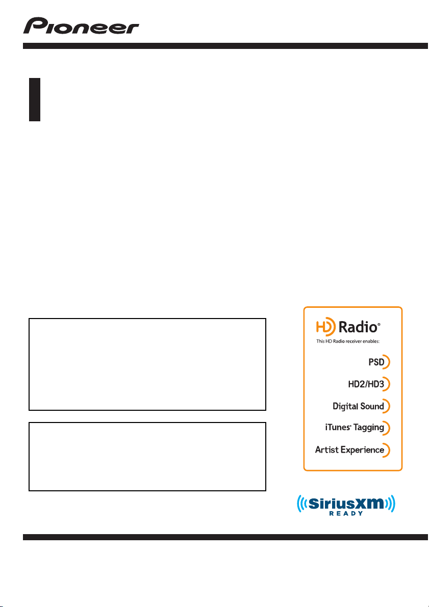
HD Radio™ reception
HD Radio stations 97
Using the touch panel keys 97
Reading the screen 98
Starting procedure 99
Selecting a band 99
Manual tuning 99
Seek tuning 99
Selecting a preset channel from the preset
channel list 100
Storing broadcast frequencies 100
Storing the strongest broadcast
frequencies 100
Tuning into strong frequencies 100
Switching the seek mode 101
Switching the reception mode 102
Storing song information to an iPod (iTunes
Tagging) 102
Operating with the hardware buttons 102
Playing a disc
Using the touch panel keys (for audio) 103
Using the touch panel keys (for video) 103
Reading the screen (for audio) 105
Reading the screen (for video) 105
Starting procedure 106
Selecting files from the file name list 106
Playing tracks in random order 106
Setting a repeat play range 106
Switching the media file type 107
Searching for the part you want to play 107
Operating the DVD menu 107
Switching the subtitle language 108
Switching the audio language 108
Frame-by-frame playback 108
Slow motion playback 108
Returning to a specified scene 108
Resuming playback (Bookmark) 109
Operating the DVD menu using touch panel
keys 109
Switching the multi-angle DVD display 109
Selecting the audio output 109
Operating with the hardware buttons 110
Playing compressed audio files
Using the touch panel keys 111
Reading the screen 112
Starting procedure (for Disc) 113
Starting procedure (for USB/SD) 113
Switching the browse mode 113
Selecting files from the file name list 114
Selecting a file from the list related to the
song currently playing (link search) 114
Playing files in random order 114
Setting a repeat play range 115
En
5
Page 6

Contents
Switching the media file type 115
Operating with the hardware buttons 115
Playing compressed video files
Using the touch panel keys 116
Reading the screen 117
Starting procedure (for Disc) 117
Starting procedure (for USB/SD) 117
Selecting files from the file name list 117
Setting a repeat play range 118
Frame-by-frame playback 118
Slow motion playback 118
Switching the media file type 118
Operating with the hardware buttons 118
Playing compressed still image files
Using the touch panel keys 119
Reading the screen 119
Starting procedure 119
Selecting files from the file name list 120
Playing files in random order 120
Setting a repeat play range 120
Switching the media file type 120
Setting the slideshow interval 120
Operating with the hardware buttons 121
Using an iPod
Using the touch panel keys (for audio) 122
Using the touch panel keys (for video) 122
Using the touch panel keys (for iTunes
Radio) 123
Reading the screen (for audio) 123
Reading the screen (for video) 124
Reading the screen (for iTunes Radio) 124
Starting procedure 125
Setting the shuffle play 125
Setting a repeat play range 125
Selecting song or video sources from the
playlist screen 126
Using iTunes Radio 127
– Playing back songs similar to the
current song 127
– Setting the current song not to be
played back again 127
– Adding the current song to the wish
list 127
Using this product’s iPod function from your
iPod 128
Changing the speed of audiobook
playback 128
Displaying lists related to the song currently
playing (link search) 129
Operating with the hardware buttons 129
Playing back music from a music app other
than iPod music, as the iPod source 129
– Using the touch panel keys 129
– Reading the screen 130
Playing music output from the Android
Auto-compatible device
Using the touch panel keys 131
Reading the screen 131
Starting procedure 132
Using your iPhone or smartphone
applications
Using AppRadio Mode 133
– Using the touch panel keys (App
control side bar) 133
– Starting procedure 134
– Using the keyboard 135
– Adjusting the image size (For
smartphone users) 136
– Displaying the image of your
application (iPhone with 30-pin
connector) 137
– Displaying the image of your
application (iPhone with Lightning
connector) 137
– Displaying the image of your
application (smartphone) 138
Using Android Auto 138
– Starting procedure 139
– Setting the driving position 139
6
En
Page 7

Contents
– Adjusting the volume 140
Using MirrorLink mode 140
– Using the touch panel keys (App
control side bar) 140
– Starting procedure 140
Using the audio mix function 141
Streaming Pandora
Pandora operations 142
Using the touch panel keys 142
Reading the screen 143
Starting procedure 143
– For iPhone with a 30-pin connector
users 144
– For iPhone with a Lightning connector
users 144
– For smartphone users 144
Selecting a Pandora station from the
list 145
Creating a station 145
Operating with the hardware buttons 145
Using Aha Radio
Using the touch panel keys 146
Reading the screen 147
Starting procedure 147
– For iPhone with a 30-pin connector
users 147
– For iPhone with a Lightning connector
users 147
– For smartphone users 148
Operating with the hardware buttons 148
Using iDatalink
Activating iDatalink Maestro 149
– Updating the iDatalink Maestro
module 149
Starting procedure 149
Hands-free phone 151
– Setting Bluetooth 151
– Phone Book screen 152
– History list screen 152
®
– Dial screen 152
– Dial confirmation screen 152
Using a Bluetooth audio player
Using the touch panel keys 153
Reading the screen 154
Starting procedure 154
Selecting files from the file name list 155
Playing files in random order 155
Setting a repeat play range 155
Operating with the hardware buttons 155
Using the SiriusXM®satellite radio
SiriusXM satellite radio operations 156
– Subscribing to the SiriusXM Satellite
Radio service 156
Using the touch panel keys 156
Reading the screen 157
Starting procedure 158
Manual tuning 159
Selecting a preset channel from the preset
channel list 159
Storing broadcast channels 159
Selecting a SiriusXM channel directly 159
Selecting a channel from a list of all
channels 160
Selecting a channel from the category
list 160
Switching the displayed list 160
Using the Replay™ function 161
Setting SiriusXM TuneStart™ 161
Using TuneScan™ 162
Using category scan 162
Using TuneMix™ 162
Checking the update Traffic and Weather
information 163
– Registering the city 163
Setting parental lock 164
– Setting the passcode 164
– Locking the channel 164
En
7
Page 8

Contents
Using the content alerts function (such as
Song Alerts, Artist Alerts and Game
Alerts) 165
– Memorizing the current contents 165
Setting the program you want to be alerted
for 165
Selecting teams for Game Alert 166
Setting the Featured Favorites function 167
Setting the update notification for Featured
Favorites 168
Using the SportsFlash™ function 168
Selecting teams for SportsFlash 169
Restoring the SiriusXM settings to the
default 170
Storing song information to an iPod (iTunes
Tagging) 170
Operating with the hardware buttons 171
Using an HDMI source
Using the touch panel keys 172
Reading the screen 172
Starting procedure 172
Using an AUX source
Using the touch panel keys 173
Reading the screen 173
Starting procedure 173
Setting the video signal 174
Switching the operation screen 174
Using AV input
Using the touch panel keys 175
Reading the screen 175
Starting procedure 175
Setting the video signal 176
Using MIXTRAX
Touch panel keys 177
Selecting an item to play songs 177
Selecting songs not to be played 177
Specifying the playback portion 178
Setting the flash pattern 178
System settings
Navigation info window 179
Setting automatic switching to the navigation
screen 179
Activating the Bluetooth audio source 179
Setting the ever scroll 180
Setting AV input 180
Setting the rear view camera 180
– Setting rear view camera
activation 181
– Setting the polarity of the rear view
camera 181
– Setting the reversed image display for
the rear view image 182
Setting the camera for Camera View
mode 182
Displaying the parking assist
guidelines 183
Setting guidelines on the rear view
image 183
Setting the second camera input 184
– Setting the second camera
activation 185
– Setting the reversed image setting for
the second camera input image 185
Turning off the demo screen 185
Selecting the system language 186
Setting the keyboard language with the
application for iPhone 186
Setting the beep sound 186
Adjusting the response positions of the
touch panel (touch panel calibration) 187
Setting the dimmer function 187
Setting whether to activate the dimmer
function 188
Setting the duration of time for the dimmer
function to be active 188
Adjusting the picture 189
Displaying the firmware version 190
Updating firmware 190
8
En
Page 9

Contents
Checking sensor learning status and driving
status 191
Clearing the status 192
Checking the connections of leads 192
Audio adjustments
Using fader/balance adjustment 194
Using balance adjustment 194
Switching sound muting/attenuation 195
Adjusting source levels 195
Adjusting the filter 198
– Adjusting the front and rear speaker
output 198
– Using the subwoofer output 198
Selecting the listening position 199
Adjusting the speaker output levels
finely 199
Adjusting the time alignment 200
Using the automatic sound levelizer 202
Using the equalizer 202
– Recalling equalizer curves 202
– Customizing the equalizer curves 203
– Using the auto-adjusted equalizer 203
Adjusting the equalizer curve automatically
(Auto EQ) 203
– Before operating the Auto EQ
function 204
– Performing Auto EQ 204
Theme menu
Selecting the background display 207
– Changing to the background display
image stored on the external storage
device (USB, SD) 207
Setting the illumination color 208
– Selecting the color from the preset
colors 208
– Creating a user-defined color 209
Selecting the theme color 209
Selecting the clock image 209
Changing the preinstalled splash
screen 210
– Changing to the splash screen stored
on the external storage device (USB,
SD) 210
Replicating the settings 211
– Exporting “Theme” settings 211
– Importing “Theme” settings 212
Setting up the video player
Setting the top-priority languages 213
– Setting the subtitle language 213
– Setting the audio language 213
– Setting the menu language 214
Setting the angle icon display 214
Setting the aspect ratio 215
Setting parental lock 215
– Setting the code number and
level 215
Displaying your DivX VOD registration
code 216
Displaying your DivX VOD deregistration
code 217
Automatic playback of DVDs 217
Setting the video signal for the rear view
camera 218
Language code chart for DVDs 219
Favorite menu
Creating a shortcut 220
Selecting a shortcut 220
Removing a shortcut 220
Common operations
Setting the time and date 221
Storing song information to an iPod (iTunes
Tagging) 221
Setting the “Sound Retriever” function 222
Changing the wide screen mode 223
Other functions
Selecting the video for the rear display 224
Setting the anti-theft function 224
– Setting the password 224
– Entering the password 225
En
9
Page 10

Contents
– Deleting the password 225
– Forgotten password 226
Restoring this product to the default
settings 226
– Restoring the default settings 226
Appendix
Troubleshooting 227
Error messages 229
Positioning technology 236
– Positioning by GPS 236
– Positioning by dead reckoning 236
– How do GPS and dead reckoning work
together? 236
Handling large errors 237
– When positioning by GPS is
impossible 237
– Conditions likely to cause noticeable
positioning errors 238
Route setting information 240
– Route search specifications 240
Handling and care of discs 240
– Built-in drive and care 241
– Ambient conditions for playing a
disc 241
Playable discs 241
– DVD-Video and CD 241
– AVCHD recorded discs 242
– Playing DualDisc 242
– Dolby Digital 242
Detailed information for playable media 242
– Compatibility 242
– Media compatibility chart 245
Bluetooth 249
SiriusXM
®
satellite radio 249
HD Radio™ Technology 249
SDHC 249
WMA/WMV 249
DivX 249
AAC 250
Google, Google Play, Android™, and Android
Auto 250
10
En
MirrorLink 250
MIXTRAX 250
Detailed information regarding connected
iPod devices 250
– iPod and iPhone 250
– Lightning 251
– App Store 251
– iOS 251
– iTunes 251
– iTunes Radio 251
Using app-based connected content 251
– Pandora
®
252
– Aha Radio 252
HDMI 252
MHL 252
IVONA Text-to-Speech 252
Notice regarding video viewing 252
Notice regarding DVD-Video viewing 252
Notice regarding MP3 file usage 253
Notice regarding open source licenses 253
Map coverage 253
Using the LCD screen correctly 253
– Handling the LCD screen 253
– Liquid crystal display (LCD)
screen 253
– Maintaining the LCD screen 253
– LED (light-emitting diode)
backlight 254
Display information 255
– Phone menu 255
– System menu 255
– Theme menu 256
– Audio menu 257
– Video Setup menu 257
– Bluetooth menu 258
Specifications 259
Page 11

Introduction
Chapter
01
Manual overview
Before using this product, be sure to read Important Information for the User (a separate
manual) which contains warnings, cautions,
and other important information that you
should note.
The screen examples shown in this manual
are those for AVIC-8100NEX. The screens may
vary according to the models.
How to use this manual
Finding the operation procedure for
what you want to do
When you have decided what you want to do,
you can find the page you need from the Con-
tents.
Finding the operation procedure from
a menu name
If you want to check the meaning of an item
displayed on screen, you will find the necessary page from the Display information at the
end of this manual.
Conventions used in this manual
Before moving on, take a few minutes to read
the following information about the conventions used in this manual. Familiarity with
these conventions will help you greatly as you
learn how to use your new equipment.
! Buttons on this product are described in
ALL CAPITALS, BOLD lettering:
e.g.)
HOME button, MODE button.
! Menu items, screen titles, and functional
components are described in bold with
double quotation marks “”:
e.g.)
“System” screen or “Audio” screen
! Touch panel keys that are available on the
screen are described in bold in brackets [ ]:
e.g.)
[Disc], [AV Source Settings].
! Extra information, alternatives and other
notes are presented in the following format:
e.g.)
p If the home location has not been stored
yet, set the location first.
! Functions of other keys on the same screen
are indicated with # at the beginning of the
description:
e.g.)
# If you touch [OK], the entry is deleted.
! References are indicated like this:
e.g.)
= For details of the operations, refer to
How to use the screens on page 22.
! Model icons shown in this manual indicate
that the description is intended for the
models indicated by the icons.
If the following icons are shown, the description is applied only to the models
shown.
e.g.)
8100NEX 7100NEX
Terms used in this manual
“Front display” and “Rear display”
In this manual, the screen that is attached to
the body of this product will be referred to as
the “Front display”. Any additional screen that
is commercially available and can be connected to this product will be referred to as the
“Rear display”.
“Video image”
“Video image” in this manual indicates moving images of DVD-Videos, Video-CDs, ROMVideos, DivX
connected to this product, such as generalpurpose AV equipment.
®
, iPod, and any equipment that is
Introduction
En
11
Page 12
Chapter
01
Introduction
“External storage device (USB, SD)”
The SD memory card, SDHC memory card
and USB memory device are collectively referred to as the “external storage device (USB,
SD)”. If it indicates the USB memory only, it is
referred to as the “USB storage device”.
“SD memory card”
The SD memory card and SDHC memory card
are collectively referred to as the “ SD memory
card”.
“iPod”
In this manual, iPod and iPhone will be referred to as “iPod”.
Notes on internal memory
Before removing the vehicle
battery
If the battery is disconnected or discharged,
the memory will be erased and must be reprogrammed.
p Some of the settings and recorded con-
tents will not be reset.
The microprocessor must be reset under the
following conditions:
! Prior to using this product for the first time
after installation.
! If this product fails to operate properly.
! If there appears to be problems with the op-
eration of the system.
! If your vehicle position is shown on the
map with a significant positioning error.
1 Turn the ignition switch OFF.
2 Press the RESET button with a pen tip
or other pointed implement.
Settings and recorded contents are reset to
the factory settings.
8100NEX 7100NEX
1
6100NEX
5100NEX
Data subject to erasure
The information is erased by disconnecting
the yellow lead from the battery (or removing
the battery itself).
p Some of the settings and recorded con-
tents will not be reset.
Resetting the microprocessor
CAUTION
Pressing the RESET button resets settings and recorded contents to the factory settings.
p Do not perform this operation when a device
is connected to this product.
p Some of the settings and recorded contents
will not be reset.
12
En
1
1 RESET button
Page 13
Basic operation
Chapter
02
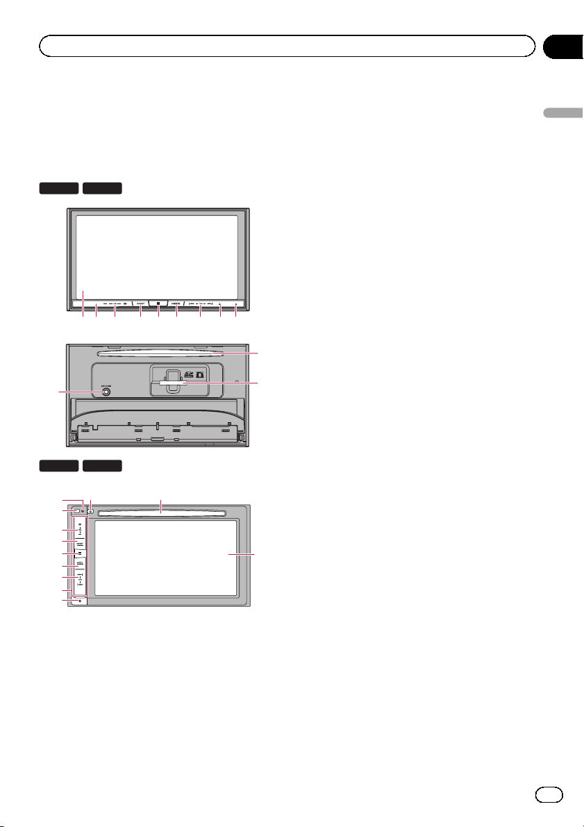
Checking part names and
functions
This chapter gives information about the names
of the parts and the main features using the buttons.
8100NEX 7100NEX
1 3 456 7 8 92
a
6100NEX
1 LCD screen
2 Remote control sensor
5100NEX
8
9
2
3
4
5
6
7
d
e
b
p The remote control CD-R33 (sold sepa-
rately) is available.
For details concerning operations, see
the remote control manual.
1
3 VOL (+/–) button
Press to adjust the AV (Audio and Video)
source volume.
4 MAP button
! Press to display the Map screen.
! Press and hold to display the rear view
5 HOME button
! Press to display the Top menu screen.
b
c
! Press and hold to activate the voice re-
6 MODE button
! Press to switch between the Application
! Press and hold to turn the display off
7 TRK button
Press to perform manual seek tuning, fast
forward, reverse and track search controls.
8 h button
9 RESET button
= For details of the operations, refer to Re-
Basic operation
= For details of the operations, refer to
How to use the screens on page 22.
camera image.
p This function is available only when
“Back Camera Input” or “2nd Cam-
era Input” is set to “On”.
= For details of the operations, refer to
How to use the screens on page 22.
cognition function.
= For details, refer to Using the voice re-
cognition function on page 86.
screen and the AV operation screen.
p If the display cannot switch from the
AV operation screen to the Applica-
tion screen when the MODE button is
pressed, the display will turn off.
= For details of the operations, refer to
How to use the screens on page 22.
when the Application screen is available.
= For details, refer to Turning off the dis-
play on page 20.
setting the microprocessor on page 12.
En
13
Page 14
Chapter
02
Basic operation
a Auto EQ microphone input jack
Use to connect a microphone for acoustical
measurement (sold separately).
b Disc-loading slot
Insert a disc to play.
= For details, refer to Inserting and ejecting
a disc on page 17.
c SD card slot
= For details, refer to Inserting and ejecting
an SD memory card on page 18.
d Detachable faceplate
button
e
Press to remove the detachable faceplate
from this product.
= For details, refer to Removing the detach-
able faceplate on page 16.
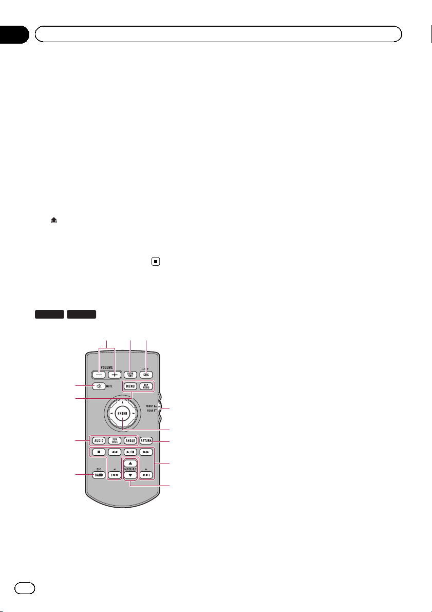
Remote control
8100NEX
1 VOLUME (+/–)
2 REAR SRC
6100NEX
2
1
3
9
a
4
5
b
6
7
c
8
! Press to cycle through all the available
rear sources.
! Press and hold to turn the rear source
off.
3 SRC/OFF
! Press to cycle through all the available
front sources.
! Press and hold to turn the front source
off.
4 Source mode select switch
Use to switch the source mode between the
front source and the rear source.
5 Thumb pad
Use to select a menu on the DVD menu.
6 RETURN
Returns to the specified point and starts
playback from there.
7 f
Press to pause or resume playback.
m
For audio
Press and hold to perform fast reverse.
For video
! Press to perform fast reverse.
! Press to change the fast reverse speed.
n
For audio
Press and hold to perform fast forward.
For video
! Press to perform fast forward.
! Press to change the fast forward speed.
o
Press to return to the previous track (chapter).
p
Press to go to the next track (chapter).
g
Press to stop playback.
If you resume playback, playback will start
from the point where you stopped. Touch
the key again to stop playback completely.
8 FOLDER/P.CH
! Press to select the next or previous disc
or folder.
14
En
Page 15
Basic operation
! Press to recall radio station frequencies
assigned to preset channel keys.
9 MUTE
Press to mute. Press again to unmute.
a MENU
Press to display the DVD menu during DVD
playback.
TOP MENU
Press to return to the top menu during DVD
playback.
b AUDIO
Press to change the audio language during
DVD playback.
SUBTITLE
Press to change the subtitle language during DVD playback.
ANGLE
Press to change the viewing angle during
DVD playback.
c BAND/ESC
! Press to select the tuner band when
tuner is selected as a source.
! Press to cancel the control mode of func-
tions.
! Press to switch between media file types
when playing the following types of data:
— Disc
— External storage device (USB, SD)
Chapter
02
Basic operation
WARNING
! Keep the battery out of the reach of children.
Should the battery be swallowed, consult a
doctor immediately.
! Batteries (battery pack or batteries installed)
must not be exposed to excessive heat such
as sunshine, fire or the like.
CAUTION
! Remove the battery if the remote control is not
used for a month or longer.
! There is a danger of explosion if the battery is
incorrectly replaced. Replace only with the
same or equivalent type.
! Do not handle the battery with metallic tools.
! Do not store the battery with metallic objects.
! If the battery leaks, wipe the remote control
completely clean and install a new battery.
! When disposing of used batteries, comply
with governmental regulations or environmental public institutions’ rules that apply in your
country/area.
Use and care of the remote
control
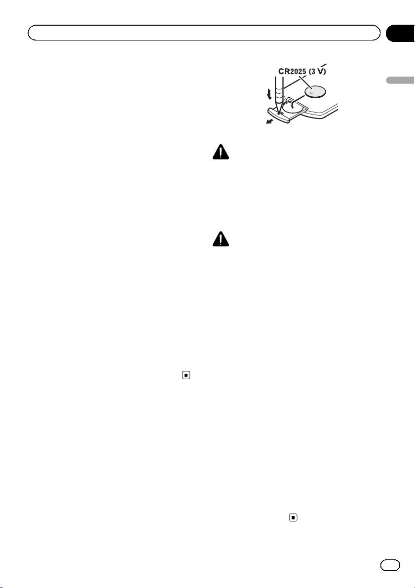
Installing the battery
Slide the tray on the back of the remote control out and insert the battery with the plus (+)
and minus (–) poles aligned properly.
! When using for the first time, pull out the
film protruding from the tray.
Using the remote control
Point the remote control in the direction of the
front panel to operate.
! The remote control may not function prop-
erly in direct sunlight.
Important
! Do not store the remote control in high tem-
peratures or direct sunlight.
! Do not let the remote control fall onto the
floor, where it may become jammed under the
brake or gas pedal.
En
15
Page 16
Chapter
02
Basic operation
Protecting your product
against theft
6100NEX
The detachable faceplate can be detached
from this product to discourage theft, as described below.
! Do not expose the detachable faceplate to ex-
! Never grip the buttons tightly or use force
! Keep the detachable faceplate out of reach of
! After removing the detachable faceplate, keep
! Do not expose the detachable faceplate to di-
! When removing or attaching the detachable
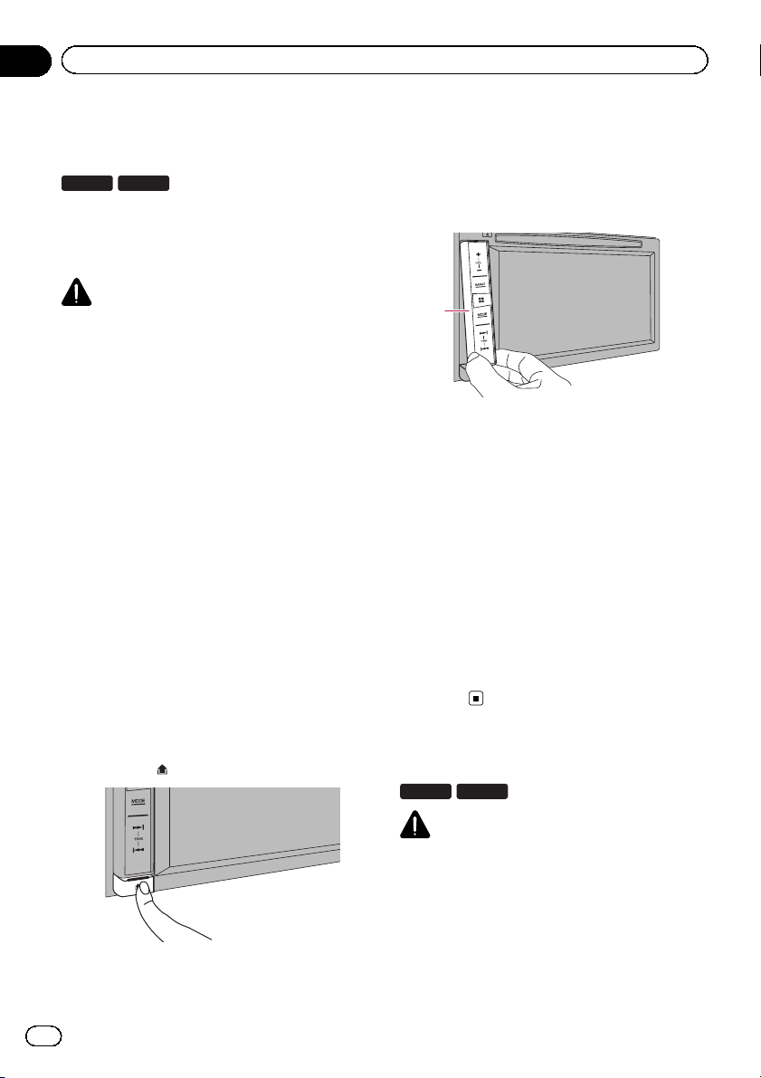
Removing the detachable
faceplate
p This product cannot be operated while the
1 Press the
5100NEX
CAUTION
cessive shock or disassemble it.
when removing or attaching the detachable
faceplate.
small children to prevent them from placing it
in their mouths.
it in a safe place so it is not scratched or damaged.
rect sunlight and high temperatures.
faceplate, do so after turning off the ignition
switch (ACC OFF).
detachable faceplate is removed from this
product.
button.
When you release your finger, the bottom of
the detachable faceplate separates slightly
from this product.
2 Gently grip the bottom of the detachable faceplate and slowly pull it outward.
1
1 Detachable faceplate
Attaching the detachable faceplate
1 Slide the detachable faceplate all the
way into this product.
Make sure the detachable faceplate is securely connected to the mounting hooks of
this product.
2 Push the lower part of the detachable
faceplate until you hear a click.
If you fail to successfully attach the detachable faceplate to this product, try again but be
careful not to force it as the panel could be
damaged.
Notes on using the LCD panel
8100NEX 7100NEX
16
WARNING
! Keep hands and fingers clear of this product
when opening, closing, or adjusting the LCD
panel. Be especially cautious of children’s
hands and fingers.
! Do not use with the LCD panel left open. If the
LCD panel is left open, it may result in injury
in the event of an accident.
En
Page 17
Basic operation
Chapter
02
CAUTION
! Do not open or close the LCD panel by force.
This may cause a malfunction.
! Do not operate this product until the LCD
panel has completely opened or closed. If this
product is operated while the LCD panel is
opening or closing, the LCD panel may stop at
that angle for safety.
! Do not place a glass or can on the open LCD
panel. Doing so may break this product.
Adjusting the LCD panel angle
8100NEX 7100NEX
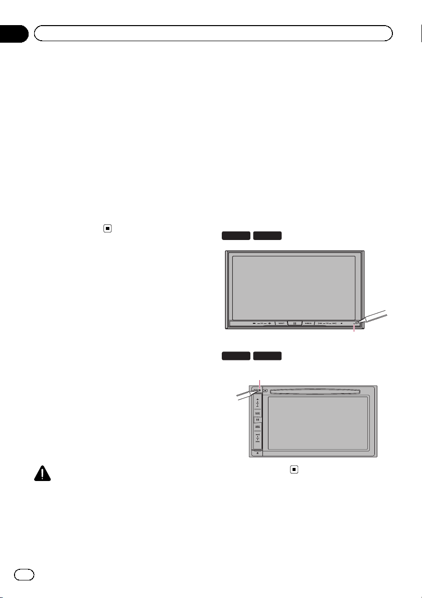
1 Press the h button.
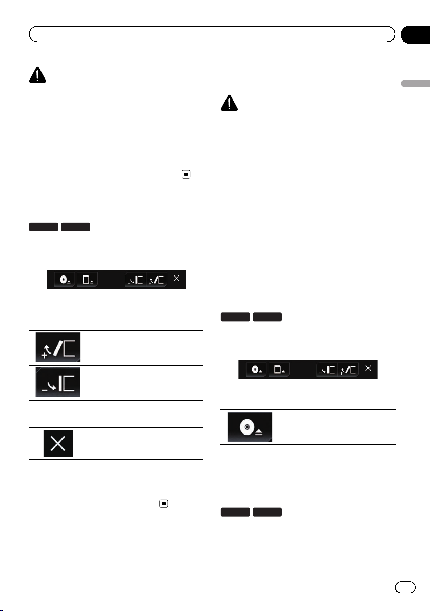
The following screen appears.
2 Touch the following keys to adjust the
angle of the LCD panel.
Laying the panel down.
Inserting/ejecting/
connecting media
CAUTION
! Do not insert anything other than a disc into
the disc-loading slot.
! Do not insert anything other than SD memory
cards into the SD card slot.
! Ejecting an SD memory card during data
transfer can damage the SD memory card. Be
sure to eject the SD memory card by the procedure described in this manual.
! Do not press the h button when an SD mem-
ory card is not fully inserted. Doing so may damage the card.
! Do not press the h button before an SD mem-
ory card has been completely removed. Doing
so may damage the card.
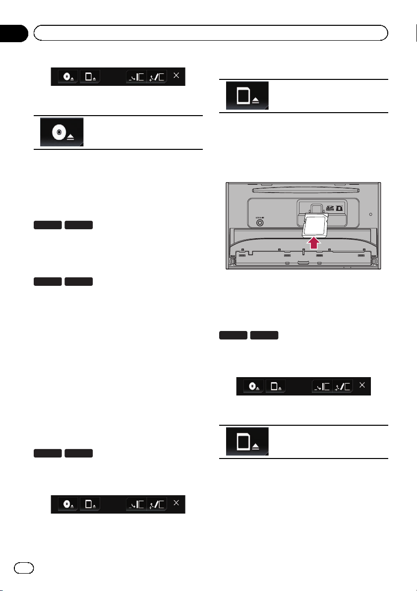
Inserting and ejecting a disc
Inserting a disc
8100NEX 7100NEX
1 Press the h button.
The following screen appears.
Basic operation
Returning the panel to the upright
position.
3 Touch the following key.
Returns to the previous screen.
p The adjusted angle of the LCD panel will be
memorized and the LCD panel will automatically return to that angle the next time the
LCD panel is opened or closed.
2 Touch the following key.
Opens the LCD panel.
3 Insert a disc into the disc-loading slot.
The disc is loaded, and the LCD panel closes.
Ejecting a disc
8100NEX 7100NEX
1 Press the h button.
The following screen appears.
En
17
Page 18
Chapter
02
Basic operation
2 Touch the following key.
2 Touch the following key.
The LCD panel opens, and the disc
is ejected.
3 Remove the disc, and press the h button.
The LCD panel closes.
Inserting a disc
6100NEX
5100NEX
% Insert a disc into the disc-loading slot.
Ejecting a disc
6100NEX
5100NEX
% Press the h button.
The disc is ejected.
Inserting and ejecting an SD
memory card
p This system is not compatible with the
Multi Media Card (MMC).
p Compatibility with all SD memory cards is
not guaranteed.
p This product may not achieve optimum per-
formance with some SD memory cards.
Opens the LCD panel.
3 Insert an SD memory card into the SD
card slot.
Insert it with the label surface face-up and
press the card until it clicks and completely
locks.
4 Press the h button.
The LCD panel closes.
Ejecting an SD memory card
8100NEX 7100NEX
1 Press the h button.
The following screen appears.
2 Touch the following key.
Inserting an SD memory card
8100NEX 7100NEX
1 Press the h button.
The following screen appears.
18
En
Opens the LCD panel.
3 Press the middle of the SD memory
card gently until it clicks.
The SD memory card is ejected.
4 Pull the SD memory card out straight.
5 Press the h button.
The LCD panel closes.
Page 19
2
Basic operation
Chapter
02
Connecting and disconnecting
an iPod
Connecting your iPod
= For details of the connections, refer to the
Installation Manual.
Disconnecting your iPod
% Pull out the cables after confirming
that no data is being accessed.
Plugging and unplugging a USB
storage device
p This product may not achieve optimum per-
formance with some USB storage devices.
p Connection via a USB hub is not possible.
p A USB cable is required for connection.
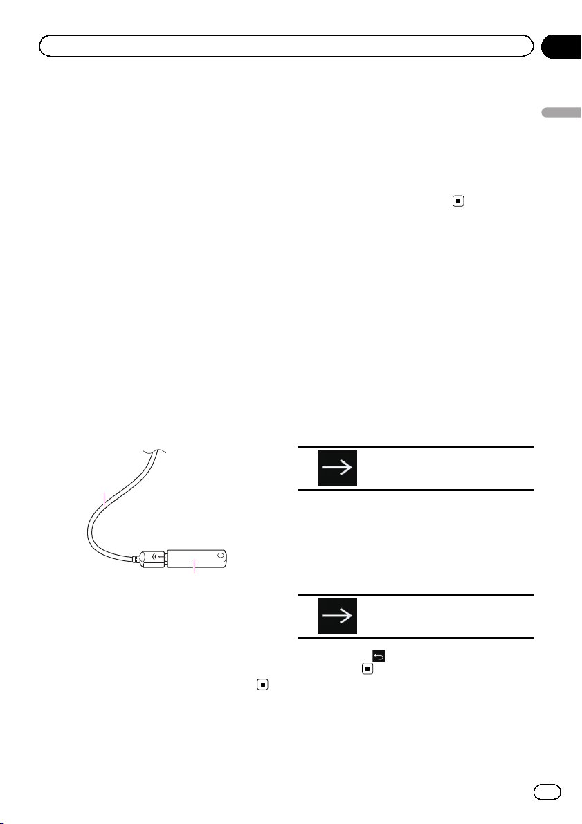
Plugging in a USB storage device
% Plug a USB storage device into the USB
cable.
1
Startup and termination
1 Start the engine to boot up the system.
After a short pause, the splash screen comes
on for a few seconds.
2 Turn off the vehicle engine to terminate the system.
This product is also turned off.
On first-time startup
When you use this product for the first time,
select the language that you want to use.
1 Start the engine to boot up the system.
After a short pause, the splash screen comes
on for a few seconds.
The “Select Program Language” screen appears.
2 Touch the language that you want to
use on screen.
3 Touch the following key.
Displays the “Smartphone Setup”
screen.
Basic operation
1 USB cable
2 USB storage device
Unplugging a USB storage device
% Pull out the USB storage device after
checking that no data is being accessed.
4 Touch the item you want to set.
= For details, refer to Information on the con-
nections and functions for each device on
page 90.
5 Touch the following key.
Displays the Top menu screen.
# If you touch , the display returns to the pre-
vious screen.
En
19
Page 20

Chapter
02
Basic operation
Regular startup
% Start the engine to boot up the system.
After a short pause, the splash screen comes
on for a few seconds.
p The screen shown will differ depending on
the previous conditions.
p Enter the password for the anti-theft func-
tion if the password entry screen appears.
p The terms appear if the screen displayed
last was the navigation screen.
Read the terms carefully, checking the details, and then touch [OK] if you agree to
the conditions.
After you touch [OK], the screen that was
displayed just before turning off the ignition
switch (ACC OFF) is displayed.
A message about the map
database
After you start using this product, a message
related to map data may be displayed.
p This message is displayed the first time you
turn on this product each month.
Turning off the display
You can turn off the display at night or when
the screen is too bright.
When the Application screen is
available
% Press and hold the MODE button.
The display turns off.
p If you touch the screen when the display is
off, it reverts to the original screen.
When the Application screen is
not available
% Press the MODE button.
The display turns off.
p If you touch the screen when the display is
off, it reverts to the original screen.
20
En
Page 21

Basic operation
Chapter
02
Basic operation
En
21
Page 22
Chapter
02
Basic operation
How to use the screens
Switching screens using the touch panel keys
b
2
a
9
8
1
6
7
5
3
4
22
En
Page 23
Basic operation
Switching screens using the hardware buttons
Chapter
02
b
a
9
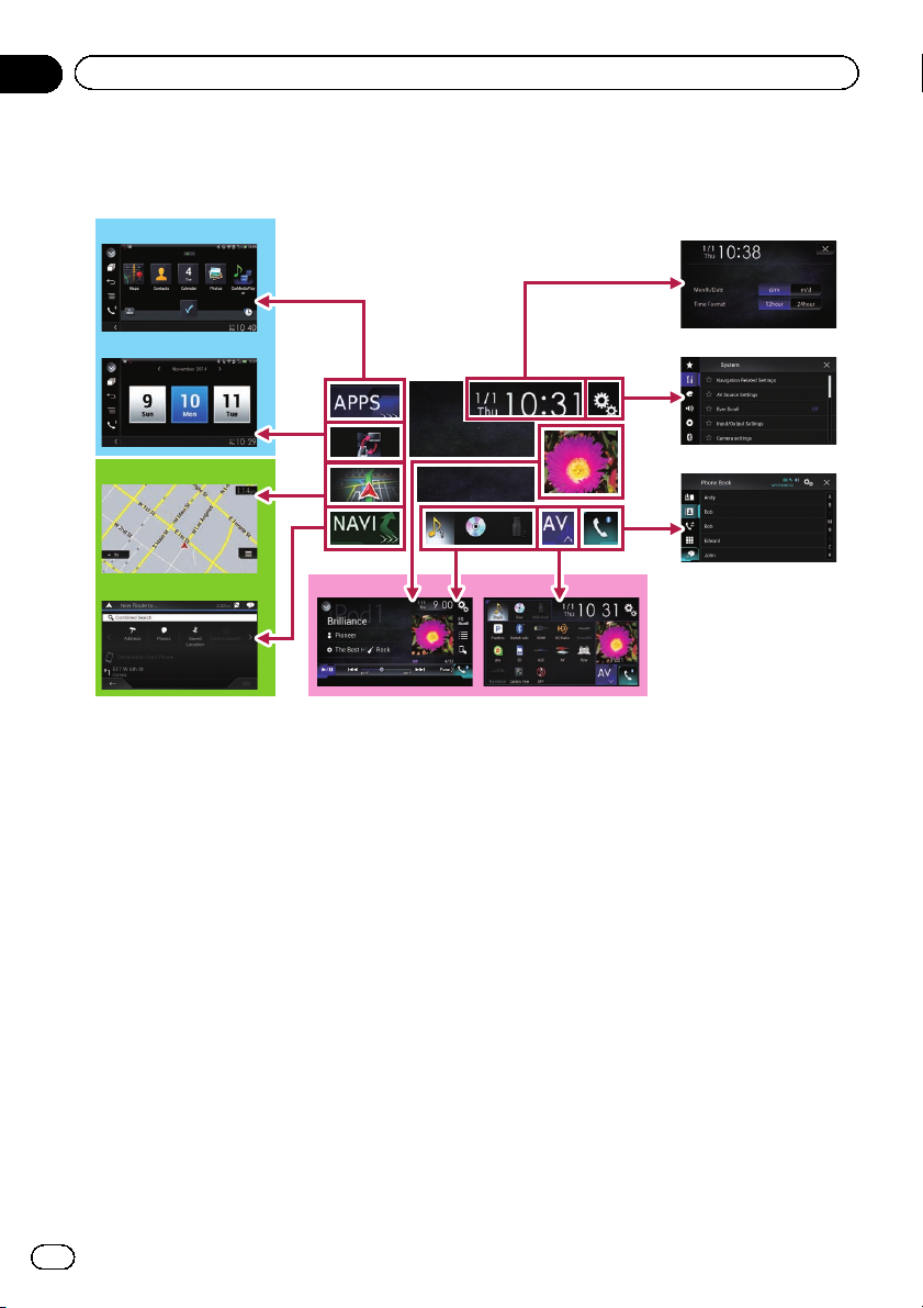
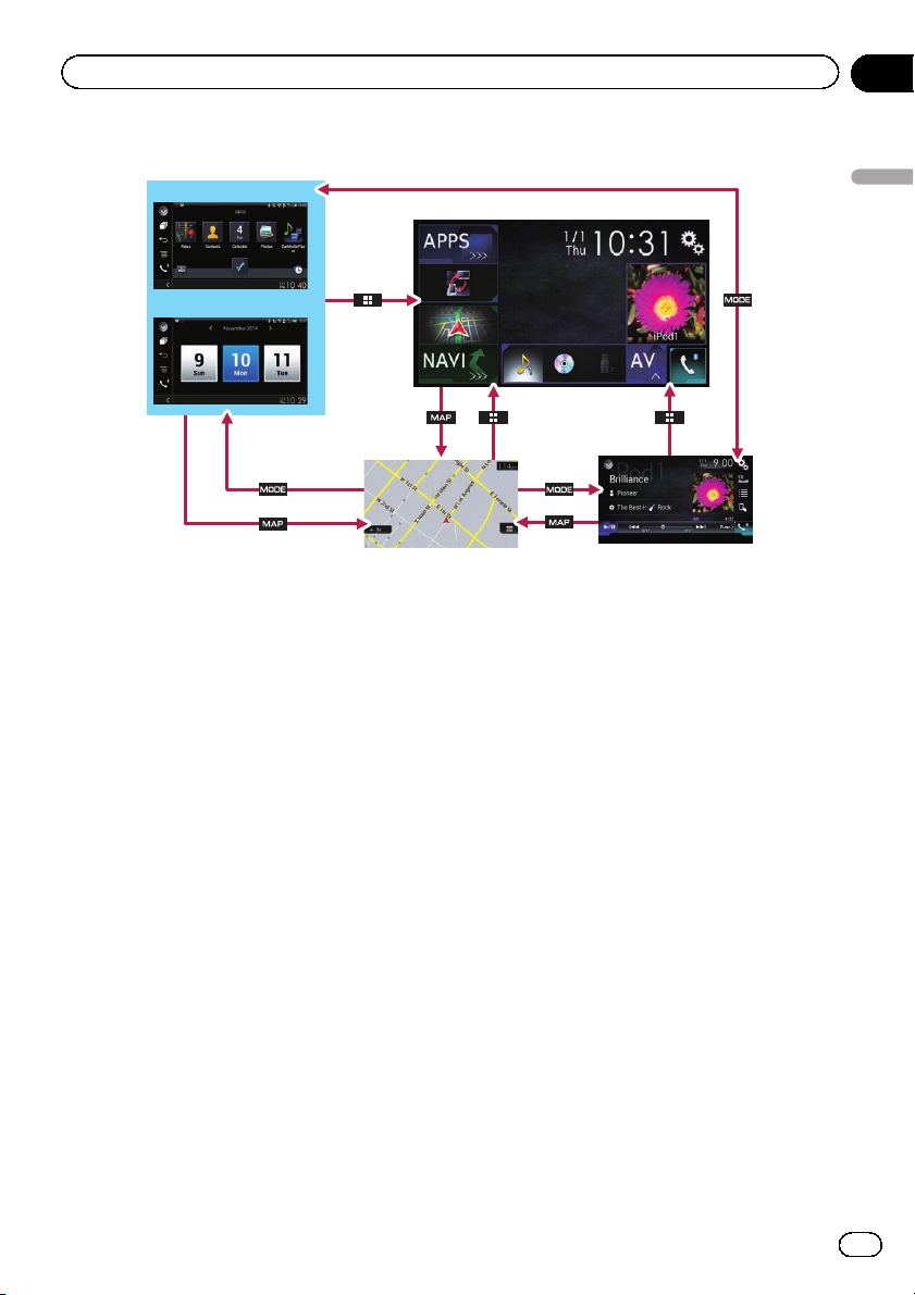
1 Top menu screen
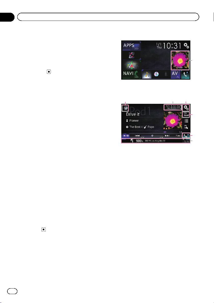
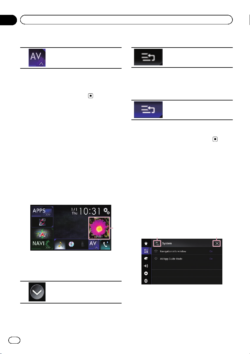
This is the starting menu to access the desired screens and operate the various functions.
p If you press the HOME button, the Top
menu screen is displayed.
p “APPS” is displayed when AppRadio
Mode or MirrorLink mode is on.
p “Android Auto” is displayed when
Android Auto is on (for AVIC-8100NEX
and AVIC-7100NEX).
2 Time and date setting screen
You can set the time and date settings.
3 Setting menu screen
You can customize the system and audio
settings, etc.
4 Phone menu screen
You can access the screen that is related to
hands-free phoning.
1
6 Favorite source icons
You can display the icons of frequently used
sources by dragging the icons to the display
area.
= For details of the operation, refer to
Changing the display order of source
icons on page 25.
7 AV operation screen
You can operate each source.
8 Navigation menu screen
You can specify way points and a destination.
9 Map screen
! You can use this screen to check the cur-
rent vehicle position information and
route to the destination.
! You can customize navigation settings.
p If you press the MAP button, the Map
screen is displayed.
Basic operation
7
5 AV source selection screen
You can select the AV source.
a Application operation screen
You can control the iPhone or smartphone
applications directly on this product.
p If applications are not available, the Ap-
plication operation screen will not be displayed.
En
23
Page 24
Chapter
02
Basic operation
b Application menu screen
This product can switch to the application
menu, on which you can display and operate the application for an iPhone or a smartphone on the screen.
p If application menus are not available,
the Application menu screen will not be
displayed.
Supported AV source
You can play or use the following sources with
this product.
! Radio (FM, AM) (*1)
! HD Radio (HD Radio
™
tuner) (*2)
! CD
! ROM (compressed audio or video files)
! DVD-Video
! Video-CD
The following sources can be played back or
used by connecting an auxiliary device.
! USB
! SD (*3)
! iPod
! My Vehicle
! Pandora
®
! Aha Radio
! Bluetooth audio
! SiriusXM
®
Satellite Radio
! AV input (AV)
! AUX
! HDMI (*2)
p (*1) Available for AVIC-5100NEX.
p (*2) Available for AVIC-8100NEX, AVIC-
7100NEX and AVIC-6100NEX.
p (*3) Available for AVIC-8100NEX and AVIC-
7100NEX.
Displaying the AV
operation screen
1 Press the HOME button to display the
Top menu screen.
2 Touch the AV operation key.
1
1 AV operation key
The AV operation screen appears.
132
4
5
6
1 Displays the source list.
= For details, refer to Selecting a front
source on the source list on page 25.
2 Displays the Time and date setting
screen.
= For details, refer to Setting the time and
date on page 221.
3 Displays the Setting menu screen.
4 Recalls equalizer curves.
= For details, refer to Using the equalizer
on page 202.
5 Displays the Phone menu screen.
= For details, refer to Displaying the phone
menu on page 80.
6 Shows the navigation information.
The distance to the next guidance point, the
name of the street on which the next guidance point is located, the name of the
street that the vehicle is currently traveling
on, the estimated time of arrival, and warning icons, etc. are displayed.
p This is not displayed for some sources.
p This is not displayed when “Navigation
info window” is set to “Off”.
24
En
Page 25
Basic operation
Chapter
02
= For details, refer to Navigation info win-
dow on page 179.
Selecting a front source on the
AV source selection screen
1 Press the HOME button to display the
Top menu screen.
2 Touch the following key.
Displays the AV source selection
screen.
3 Touch the source icon you want to select.
The AV operation screen of the selected
source appears.
Selecting a front source on the
source list
p This function is not available during a call
via this product.
1 Press the HOME button to display the
Top menu screen.
2 Touch the AV operation key.
4 Touch the source key you want to select.
The AV operation screen of the selected
source appears.
p “Camera View” is available only when
“Back Camera Input” or “2nd Camera
Input” is set to “On”.
Selecting a rear source
You can select a source output to the rear display.
= For details of the operations, refer to Select-
ing the video for the rear display on page
224.
Turning off the AV source
Turn off the AV source to stop playing or receiving the AV source.
1 Press the HOME button to display the
Top menu screen.
2 Touch the following key.
Displays the AV source selection
screen.
3 Touch [OFF].
The AV source is turned off.
Basic operation
1 AV operation key
The AV operation screen appears.
3 Touch the following key.
Displays the source list.
1
Changing the display order
of source icons
You can change the display order of source
icons on the AV source selection screen.
p This setting is available only when you stop
your vehicle in a safe place and apply the
parking brake.
p This function is not available during a call
via this product.
1 Press the HOME button to display the
Top menu screen.
En
25
Page 26
Chapter
02
Basic operation
2 Touch the following key.
Displays the AV source selection
screen.
3 Touch and hold a source icon, and drag
the icon to the desired position.
p If the source icon is moved, the order of the
source list is also changed.
Changing the display order
of source keys
You can change the display order of source
keys on the source list.
p This setting is available only when you stop
your vehicle in a safe place and apply the
parking brake.
p This function is not available during a call
via this product.
1 Press the HOME button to display the
Top menu screen.
2 Touch the AV operation key.
4 Touch the following key.
The source keys can be moved.
5 Drag the source key to the desired position.
6 Touch the following key.
Returns to the previous screen.
p If the source key is moved, the source icons
displayed on the Top menu screen and the
AV source screen are also moved.
Using the touch panel
You can operate this product by touching the
marks and items (touch panel keys) displayed
on the screen directly with your fingers.
p To protect the LCD screen from damage, be
sure to touch the touch panel keys only
with your finger and do so gently.
1 AV operation key
The AV operation screen appears.
3 Touch the following key.
Displays the source list.
26
En
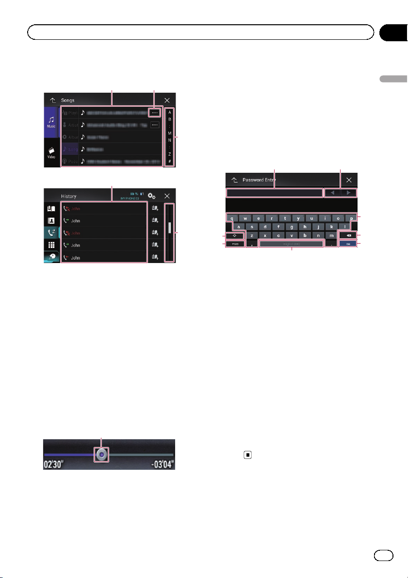
Using the common touch panel
keys
1
1 2
1 Returns to the previous screen.
2 Closes the screen.
Page 27
Basic operation
Chapter
02
Operating list screens
1
1
1 Touching an item on the list selects the item
or narrows down the options.
2 Appears when all characters are not displayed
on the display area.
If you touch the key, the rest of the characters
are scrolled for display.
3 Appears when items cannot be displayed on a
single page only.
Drag the slider bar to view any hidden items.
Also, you can drag the list to view any hidden
items.
2
3
3
Operating the time bar
1
p This function is not available when
using iPod function with an iPhone 6
Plus, iPhone 6, iPhone 5s, iPhone 5c,
iPhone 5, or iPod touch (5th generation).
p This function is not available for some
media or sources.
Operating the on-screen keyboard
21
3
8
7
6
1 Displays the characters that are entered. If
there is no text in the box, an informative
guide with text appears.
2 Moves the cursor to the right or left for a num-
ber of characters equivalent to the number of
touches.
3 Enters the characters in the text box.
4 Deletes the input text to the left of the cursor
one letter at a time. Continuing to touch the
key deletes all of the text.
5 Confirms the entry and proceeds to the next
step.
6 Enters a space.
A space equivalent to the number of touches
is inserted.
7 Switches between alphabet and numbers/
symbols.
8 Switches between capital and lower case
letters.
4
5
Basic operation
1 You can change the playback point by drag-
ging the key.
p Playback time corresponding to the po-
sition of the key is displayed while dragging the key.
En
27
Page 28
Chapter
02
Basic operation
On first-time startup of the
navigation system
When you use the navigation function for the
first time, an initial setup process starts automatically. Follow the steps below.
p You can change the language and GPS log
setting later using [Regional] and [Usage
Reports] in the “Settings” screen. Other
settings can be restarted later using [Start
Configuration Wizard] in the “Settings”
screen.
1 Press the HOME button to display the
Top menu screen.
2 Touch the following keys.
Initiates the initial startup of the
navigation system.
p The first time that the MAP button is
pressed, the navigation system also begins
its initial startup.
After a short pause, the splash screen comes
on for a few seconds.
The “Language” screen appears.
3 Select the language that you want to
use on the screen, then touch [Select].
The “EULA” screen appears.
4 Read the terms carefully, checking the
details, and then touch [Accept] if you
agree to the conditions.
The “Usage Reports” screen appears.
5 Touch [Yes].
If you touch [Yes], the software collects usage
information and GPS logs that may be used
for improving the application and the quality
and coverage of maps.
p If you do not wish to activate information
collection, touch [No].
The configuration wizard starts.
6 Touch [Next].
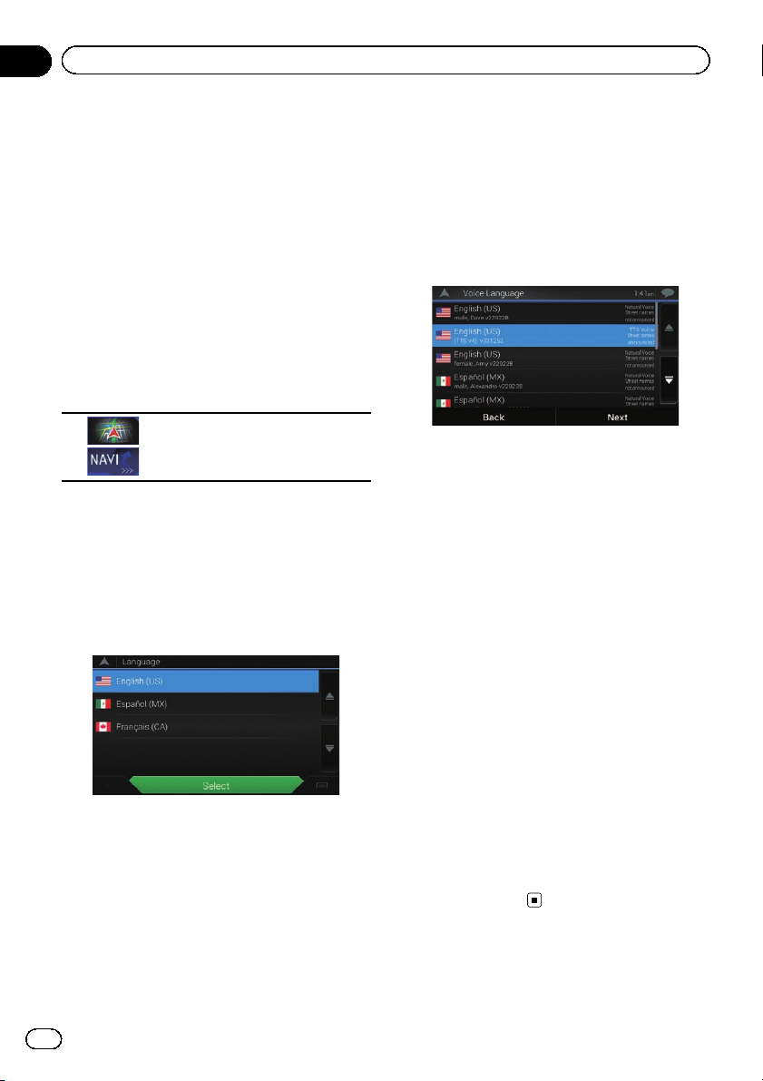
The “Voice Language” screen appears.
7 Select the language that you want to
use for voice guidance messages, then
touch [Next].
8 If needed, modify the unit settings,
then touch [Next].
The “Route Preferences” screen appears.
9 If needed, modify the default route
planning options, then touch [Next].
10 Touch [Activate], then [Next].
A message saying that the connected online
features are activated appears if you activate
these services right away.
= For details, refer to “Online Services” set-
tings on page 69.
p You will need to install the AVICSYNC App
on your iPhone or smartphone first in order
to be able to use online services, which require a paid subscription. Service coverage
for each online service may vary depending
on the content provider providing the service.
= For details, refer to Expanding the use of
the navigation functions on page 71.
11 Select the connected services you want
to use, then touch [Next].
The initial setup is now complete. The Map
screen appears and you can start using the
navigation system.
28
En
Page 29
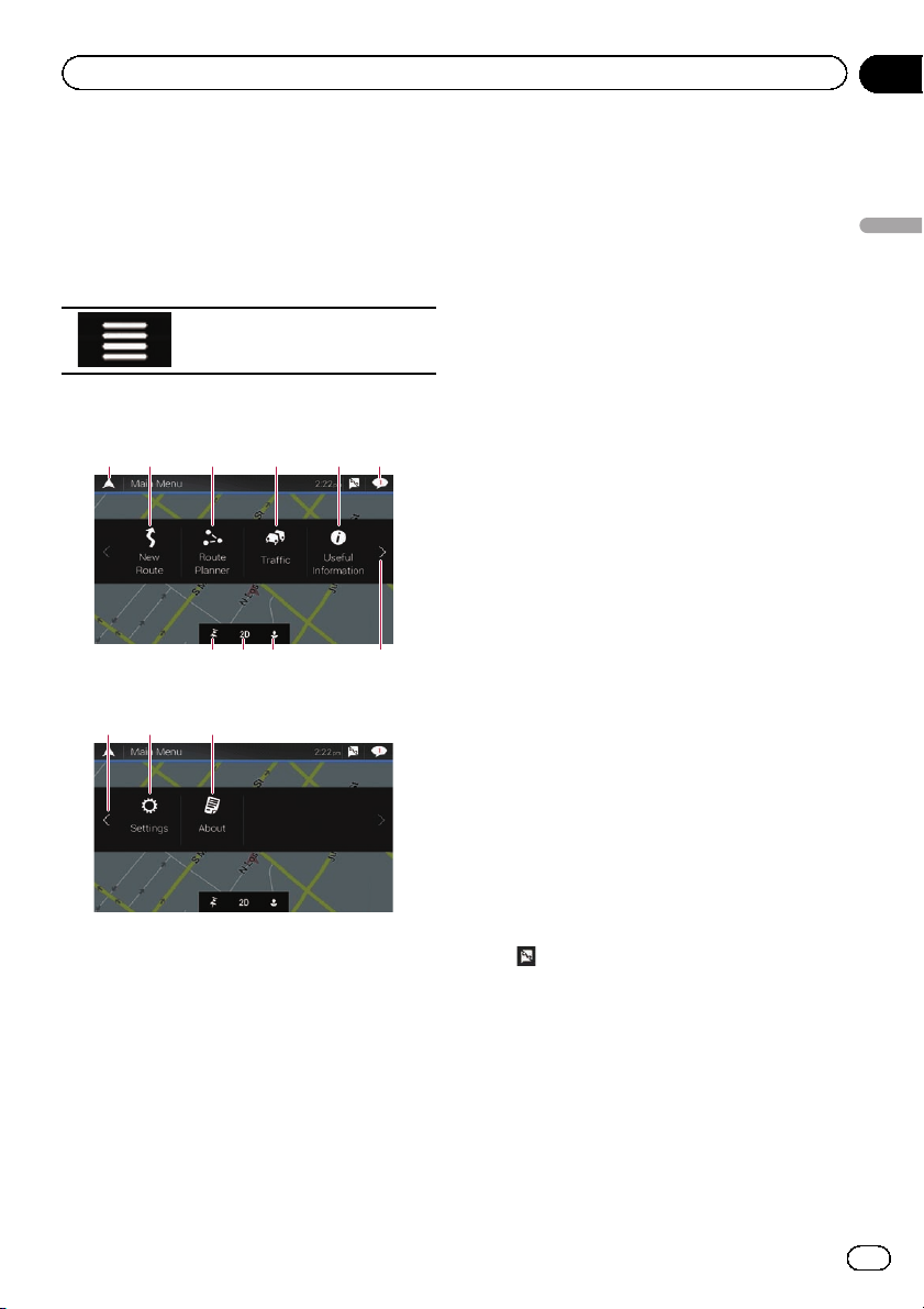
How to use the Navigation menu screen
Chapter
03
Operating the Navigation
menu screen
1 Press the MAP button.
The Map screen appears.
2 Touch the following key.
Displays the navigation menu on
the Map screen.
The following screen appears.
Touch panel keys (Page 1)
21 63 4
789
Touch panel keys (Page 2)
cb d
You will see the following keys when you are
navigating without a planned route.
1 Returns to the Map screen.
2 Searches for your destination by the ad-
dress or coordinates, or searches for the selected place of interest, etc.
= For details, refer to Chapter 5.
3 Builds your route or edits the route cur-
rently set.
= For details, refer to Building a route
using “Route Planner” on page 46.
4 Displays the “Traffic Summary” screen.
5
a
= For details, refer to Checking the traffic
incidents on the map on page 55.
p For AVIC-5100NEX, this key becomes ac-
tive when the online traffic feature is
available.
5 Displays useful information to support your
driving.
= For details, refer to Chapter 9.
6 Displays notifications that contain impor-
tant information.
7 Displays the location that you saved as a fa-
vorite.
= For details, refer to Selecting a destina-
tion from stored locations on page 41.
8 Switches among 2D, 3D, and 2D North up
view modes.
9 Displays the “User Profiles” screen where
you can create new profiles or edit the existing profiles.
If multiple drivers are using this product,
they can create their own profiles with their
own settings. If you select a new profile,
this product restarts so that the new settings can take effect.
a Displays the next page of the navigation
menu.
b Displays the previous page of the naviga-
tion menu.
c Configures the navigation-related settings
and enables you to access the “SyncTool”
screen.
= For details, refer to Chapter 10.
d Displays the information of your navigation
system (the version information, or licenses, for example).
on the upper right corner of the screen
p
is used for AVICSYNC App connection.
= Be sure read Expanding the use of the
navigation functions (page 71) before
using the AVICSYNC function.
p When you are navigating a planned route,
the following route-related keys are available.
How to use the Navigation menu screen
En
29
Page 30
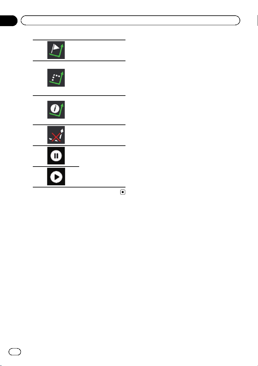
Chapter
03
How to use the Navigation menu screen
Adds a waypoint.
Displays route alternatives, parts of the
route to avoid, or specific roads in your
planned route to
avoid.
Displays the route in
its full length on the
map, and displays
route parameters and
route alternatives.
Deletes your route or
removes a waypoint.
Suspends and resumes the route guidance.
30
En
Page 31

How to use the map
Chapter
04
Most of the information provided by your navigation system can be seen on the map. You need to
become familiar with how information appears
on the map.
How to read the Map screen
1
2
3
4
5
6
7
8
p The following information marked with an
asterisk (*) appears only when a route is
set.
p Depending on the conditions and settings,
some items may not be displayed.
p AV information is displayed at the bottom
of the Map screen.
p You can select whether you want to see the
speed limit sign on the map all the time. If
you exceed the speed limit, the sign color
will change.
= For details, refer to “Warnings” settings
on page 66.
1 Shows the number and name of the street to
be used (or next guidance point).*
2 Shows the next guidance point (maneuver).*
Both the type of the event (turn, traffic circle,
exiting freeway, etc.) and its distance from the
current position are displayed. A smaller icon
shows the type of the second next maneuver if
it is near the next maneuver.
= For details, refer to Frequently shown
route events on page 34.
3 Shows the distance to the next guidance point
(maneuver).*
4 Shows the second maneuver arrow.*
5 Indicates the current location of your vehicle.
The apex of the triangular mark indicates your
a
9
orientation and the display moves automatically as you drive.
6 Displays the data field.
Touching this field displays the “Trip Compu-
ter” screen.
Touch and hold down this key and then select
the values that you wish to have displayed to
customize the data fields in the corner of the
Map screen.
= For details, refer to Data Fields on page
67.
7 Shows the name of the street (or city) that
your vehicle is traveling on (or in).
8 Indicates the current route.*
The route currently set is highlighted in color
on the map.
9 Displays the Navigation menu screen.
Indicates the progress to the final destination.*
a
AV information bar
AV information is displayed at the bottom of
the Map screen.
12 34
1 Displays the source list.
= For details, refer to Selecting a front
source on the source list on page 25.
2 Shows the current status of AV source briefly.
3 You can turn on or off the communication be-
tween the AVICSYNC App and the navigation
system by touching the key.
4 Displays the Phone menu screen.
= For details, refer to Displaying the phone
menu on page 80.
How to use the map
En
31
Page 32

Chapter
04
How to use the map
Operating the Map screen
Changing the scale of the map
p There is a limit to map scaling in 3D map
view mode. If the map scale is zoomed out
further, the map is zoomed out in 2D map.
= For details, refer to Switching between
2D, 3D, and 2D North up views on page
32.
1 Press the MAP button.
The Map screen appears.
2 Pinch or expand the map to zoom out
or in.
Touch anywhere on the map during navigation.
3 Touch the following key.
The map returns to the current position.
p If you press the MAP button, the map re-
turns to the current position.
p For information on the controls when the
scrolled map is displayed, refer to Control
keys on the scrolled map on page 33.
Smart Zoom
Your navigation system features “Smart Zoom”
that works in two ways:
! When the route is set:
When approaching a turn, “Smart Zoom”
will zoom in and raise the view angle to enable you to easily recognize your maneuver
at the next junction. If the next turn is at a
distance, it will zoom out and lower the
view angle to be flat so you can see the
road in front of you.
! When the route is not set:
“Smart Zoom” will zoom in if you drive
slowly and zoom out when you drive at
high speed.
Switching between 2D, 3D, and
2D North up views
You can switch how the map is displayed. For
2D map view mode, you can select between
“Heading up” and “North up”.
! Heading up:
The map display always shows the vehicle’s
direction as proceeding toward the top of
the screen.
! North up:
The map display always has north at the
top of the screen.
p The map orientation is fixed at “Heading
up” when the 3D map screen is displayed.
1 Press the MAP button.
The Map screen appears.
2 Touch the following key.
Displays the navigation menu on
the Map screen.
3 Touch the following key.
Each time you touch the key the setting
changes.
Indicates 2D Heading up view
mode is currently selected.
Indicates 3D Heading up view
mode is currently selected.
Indicates 2D North up view mode
is currently selected.
4 Touch the following key.
Returns to the Map screen.
p If you press the MAP button, you can return
to the Map screen.
32
En
Page 33

How to use the map
Chapter
04
p For information on the controls when the
scrolled map is displayed, refer to Control
keys on the scrolled map on page 33.
Scrolling the map to the
position you want to see
1 Press the MAP button.
The Map screen appears.
2 Touch and drag the map in the desired
direction to scroll.
If you place the cursor on the desired location,
a brief overview about the location will appear
at the top of the screen, showing the street
name and other information for the location.
3 Touch the following key.
The map returns to the current position.
p If you press the MAP button, the map re-
turns to the current position.
Control keys on the scrolled map
3 Touch the following key.
Zooms in.
Zooms out.
Changes the map view mode (the
map mode currently selected is
shown).
Tilts up.
Tilts down.
Rotates left.
Rotates right.
Cancels map rotation.
How to use the map
1 Press the MAP button.
The Map screen appears.
2 Touch anywhere on the map.
The cursor and control keys appear.
p You can change the vertical view angle of
the map in 3D mode only.
= For details, refer to Switching between
2D, 3D, and 2D North up views on page
32.
4 Touch the following key.
The map returns to the current position.
p If you press the MAP button, the map re-
turns to the current position.
En
33
Page 34

Chapter
04
How to use the map
Understanding the route
guidance
Once the route guidance begins, the system
provides various guides by voice, text indications and signs.
Frequently shown route events
Icon Meaning
Turn left.
Turn right.
Turn back.
Bear right.
Turn sharp left.
Keep left.
Icon Meaning
Board ferry.
Leave ferry.
Approaching a waypoint.
Approaching the destination.
When navigating on multilane roads, you will
need to make sure to take the proper lane for
the recommended route.
If there is lane information available in the
map data, the navigation system will display
the lanes and corresponding directions of travel at the bottom of the map using small arrows. Highlighted arrows represent the lane
and direction that you need to take for the recommended route.
Lane information
34
En
Continue straight though the intersection.
Go left on the traffic circle, 3rd exit
(next maneuver).
Enter traffic circle (maneuver after
the next maneuver).
Enter freeway.
Exit freeway.
Signs are displayed at the top of the map. Sign
colors and design styles are similar to those of
the actual signs in place above or along the indicated roads. These signs display select destinations and the road number of the road that
the relevant lane leads to.
Page 35

How to use the map
Chapter
04
If you are approaching a complex intersection
and the necessary information exists, the map
is replaced with a 3D view of the junction.
Signposts
Junction view
p If the data for these items is not contained
in the map data, the information is not
available even if there are signs on the actual road.
When you set “ Offer Freeway Services” to
“on”, the
on freeways. Touch the icon to open the details
of the next few exits or service stations. In addition, touch an item to show its location on
the map. You can set it as a waypoint easily.
p If you want to display other types of POIs
for the exits, you can change the icons in
“Services Displayed”.
= For details, refer to “Navigation Map” set-
tings on page 66.
icon appears while you are driving
Browsing the data field
The data fields are different when you are navigating a route and when you have no specified
destination. For example, the data field provides the following information.
! When the route is set:
Distance to final destination, time needed
to reach the final destination and estimated
arrival time are shown.
How to use the map
! When the route is not set:
Direction or altitude is shown.
p Touching and holding the field allows you
to display the setting screen for the field.
p The estimated time of arrival is an ideal
value calculated based on the speed limit
value set in “Max. Speed” of vehicle type
setting and the actual driving speed. The
estimated time of arrival is only a reference
value, and does not guarantee arrival at
that time.
= For details, refer to “Route Preferences”
settings on page 63.
When the system cannot
receive a GPS signal
A triangular mark shows the current position
of your vehicle.
En
35
Page 36

Chapter
04
How to use the map
When a GPS position is available, the triangular mark is displayed in full color.
When there is no GPS position, the triangular
mark is transparent. It shows your last known
position.
36
En
Page 37

Searching for a destination
Chapter
05
CAUTION
For safety reasons, these route-setting functions
are not available while your vehicle is in motion.
To enable these functions, you must stop in a
safe place and put on the parking brake.
p Some information regarding traffic regula-
tions depends on the time when the route
calculation is performed. Thus, the information may not correspond with a certain
traffic regulation when your vehicle actually
passes through the location in question.
Also, the information on the traffic regulations provided applies for a passenger vehicle, and not for a truck or other delivery
vehicles. Always follow the actual traffic
regulations when driving.
p [Destination from Phone] and [Online
Search] on the “New Route to...” screen
can be used when the AVICSYNC App connection is established.
= Be sure read Expanding the use of the
navigation functions (page 71) before
using the AVICSYNC function.
Searching for a location by
address
The most frequently used function is “Ad-
dress”, in which the address is specified and
the location is searched.
p Depending on the search results, some
steps may be skipped.
1 Press the MAP button.
The Map screen appears.
2 Touch the following key.
Displays the navigation menu on
the Map screen.
3 Touch [New Route].
The “New Route to...” screen appears.
4 Touch [Address].
The “Find Address” screen appears.
Searching for a destination
5 Touch the following text box and set
the destination you are looking for.
! Country:
By default, your navigation system proposes
the country where you are.
If you want to change the area to search set
another country.
! City or ZIP Code:
By default, your navigation system proposes
the city/town where you are. You can select
the city/town using its postal code instead
of its name.
! Street:
If the street name is not available, touch
[Go to City] and select the city/town. This
way the center of the selected city/town becomes the destination of the route.
! Select House Number or Intersection:
This item will be displayed after you have
set a street. If the house number is not
available, touch [Go to Street] and select
the street. This way the center of the selected street becomes the destination of the
route.
After you touch the selected address to finish
the address search, the searched location appears on the Map screen.
6 Touch [Select as Destination] on the
“Map Location” screen.
= For details on the operations in the “Map
Location” screen, refer to Using the “Map
Location” screen on page 45.
En
37
Page 38

Chapter
05
Searching for a destination
After touching [Select as Destination], the
“Route Summary” screen appears and countdown begins. When the countdown ends, the
guidance automatically starts. If the screen is
touched anywhere during the countdown, the
countdown stops and the screen will stay as it
is.
= For details on the operations in the “Route
Summary” screen, refer to Checking route
information and preferences on page 48.
7 Touch [Start Navigation].
Your navigation system starts the route guidance.
= For details of the route guidance, refer to
Understanding the route guidance on page
34.
Searching for Points of
Interest (POI)
Information about various facilities (Points Of
Interest – POI), such as gas stations, parking
lots or restaurants, is available. You can
search for a POI by selecting the category (or
entering the POI Name).
Searching for POIs using preset
categories
The preset search allows you to quickly find
the most frequently selected types of POIs.
1 Press the MAP button.
The Map screen appears.
2 Touch the following key.
Displays the navigation menu on
the Map screen.
3 Touch [New Route].
The “New Route to...” screen appears.
4 Touch [Places].
The “Places” screen appears.
The preset search categories are as follows.
! Gas Station
! Accommodation
! Restaurant
! Parking
p When a route is not set, POIs are searched
for around the current position.
p When the current position is not available
either (no GPS signal), POIs are searched
for around the last known position.
p When a route is set, “Gas Station” and
“Restaurant” are searched for along the
route, and “Accommodation” and “Park-
ing” are searched for around the destina-
tion.
5 Touch the category you want.
The results appear in a list.
6 Touch the POI you want.
The searched location appears on the Map
screen.
# If you touch , you can sort the results or
show the locations of all facilities on the map.
7 Touch [Select as Destination] on the
“Map Location” screen.
= For details on the operations in the “Map
Location” screen, refer to Using the “Map
Location” screen on page 45.
After touching [Select as Destination], the
“Route Summary” screen appears and countdown begins. When the countdown ends, the
guidance automatically starts. If the screen is
touched anywhere during the countdown, the
countdown stops and the screen will stay as it
is.
38
En
Page 39

Searching for a destination
Chapter
05
= For details on the operations in the “Route
Summary” screen, refer to Checking route
information and preferences on page 48.
8 Touch [Start Navigation].
Your navigation system starts the route guidance.
= For details of the route guidance, refer to
Understanding the route guidance on page
34.
Searching for POIs by
categories or directly from the
name of the facilities
You can search for POIs by their categories
and subcategories. You can also search for
POIs by their names in each of their categories.
1 Press the MAP button.
The Map screen appears.
2 Touch the following key.
Displays the navigation menu on
the Map screen.
3 Touch [New Route].
The “New Route to...” screen appears.
4 Touch [Places].
The “Places” screen appears.
5 Touch [Search Among All Places].
The “Search by Category” screen appears.
6 Touch [Around Here] and then select
the area in which the POIs should be
searched for.
! Category View:
You can select whether or not POI categories are displayed.
! Around Here:
Searches around the current position. Or,
around the last known position if the current position is not available. (The results
will be listed in order of the distance from
this position.)
! In a City:
Searches for a place within a selected city/
town. (The results will be listed in order of
the distance from the center of the selected
city/town.)
! Around Destination:
Searches for a place around the destination
of the current route. (The results will be
listed in order of the distance from the destination.)
p This key is active only when the route is
set.
! Along Route:
Searches along the current route, and not
around a point already set. This is useful
when searching for a stopover that results
in a minimal detour, such as searching for
gas stations or restaurants. (The results will
be listed in order of the length of the necessary detour.)
p This key is active only when the route is
set.
7 Select one of the categories, subcategories or brands to narrow down the
places.
The screen appears showing all places in the
selected main category around the selected location or along the route.
# Touch [Search by Name] and enter the name
of the place using the keyboard.
8 Touch the POI you want.
The searched location appears on the Map
screen.
Searching for a destination
En
39
Page 40

Chapter
05
Searching for a destination
# If you touch , you can change the sort
method of the results.
9 Touch [Select as Destination] on the
“Map Location” screen.
= For details on the operations in the “Map
Location” screen, refer to Using the “Map
Location” screen on page 45.
After touching [Select as Destination], the
“Route Summary” screen appears and countdown begins. When the countdown ends, the
guidance automatically starts. If the screen is
touched anywhere during the countdown, the
countdown stops and the screen will stay as it
is.
= For details on the operations in the “Route
Summary” screen, refer to Checking route
information and preferences on page 48.
10 Touch [Start Navigation].
Your navigation system starts the route guidance.
= For details of the route guidance, refer to
Understanding the route guidance on page
34.
Searching for providers nearby
that offer emergency or
roadside assistance services
IMPORTANT
Never use this product to route to hospitals,
police stations or similar facilities in an emergency. Stop using any functions relating to the
hands-free phoning and please call the appropriate emergency number.
You can search for locations that provide
emergency or roadside assistance in the surrounding areas.
p This information does not necessarily cor-
respond to actual information. Utilize the
information for your reference.
1 Press the MAP button.
The Map screen appears.
2 Touch the following key.
Displays the navigation menu on
the Map screen.
3 Touch [Useful Information].
The “Useful Information” screen appears.
4 Touch [Help Nearby].
The “Help Nearby ” screen appears.
The preset search categories are as follows.
! Car Repair
! Health
! Police
! Gas Station
5 Touch the category you want.
The results appear in a list.
6 Touch the POI you want.
The searched location appears on the Map
screen.
# If you touch , you can change the sort
method of the results.
7 Touch [Select as Destination] on the
“Map Location” screen.
= For details on the operations in the “Map
Location” screen, refer to Using the “Map
Location” screen on page 45.
After touching [Select as Destination], the
“Route Summary” screen appears and countdown begins. When the countdown ends, the
guidance automatically starts. If the screen is
touched anywhere during the countdown, the
countdown stops and the screen will stay as it
is.
40
En
Page 41

Searching for a destination
Chapter
05
= For details on the operations in the “Route
Summary” screen, refer to Checking route
information and preferences on page 48.
8 Touch [Start Navigation].
Your navigation system starts the route guidance.
= For details of the route guidance, refer to
Understanding the route guidance on page
34.
Selecting a destination
from stored locations
Storing locations you visit frequently saves
time and effort.
Selecting an item from the list provides an
easy way to specify the position.
The list of saved locations contains two preset
categories: Home and Work.
p This function is available if locations have
been registered in “Saved Location”.
= For details, refer to Storing a location in
“Saved Location” on page 51.
1 Press the MAP button.
The Map screen appears.
2 Touch the following key.
Displays the navigation menu on
the Map screen.
6 Touch [Select as Destination] on the
“Map Location” screen.
= For details on the operations in the “Map
Location” screen, refer to Using the “Map
Location” screen on page 45.
After touching [Select as Destination], the
“Route Summary” screen appears and countdown begins. When the countdown ends, the
guidance automatically starts. If the screen is
touched anywhere during the countdown, the
countdown stops and the screen will stay as it
is.
= For details on the operations in the “Route
Summary” screen, refer to Checking route
information and preferences on page 48.
7 Touch [Start Navigation].
Your navigation system starts the route guidance.
= For details of the route guidance, refer to
Understanding the route guidance on page
34.
Selecting a destination
from stored routes
Storing routes you use frequently saves time
and effort.
p This function is not available if no routes
have been registered in “Saved Routes”.
= For details, refer to Storing a route in
“Saved Routes” on page 52.
Searching for a destination
3 Touch [New Route].
The “New Route to...” screen appears.
4 Touch [Saved Location].
The “Saved Location” screen appears.
# If you touch and then [Edit], you can edit
the details of saved locations.
5 Touch the entry you want.
The searched location appears on the Map
screen.
1 Press the MAP button.
The Map screen appears.
2 Touch the following key.
Displays the navigation menu on
the Map screen.
3 Touch [New Route].
The “New Route to...” screen appears.
4 Touch
to show the next page.
En
41
Page 42

Chapter
05
Searching for a destination
5 Touch [Saved Routes].
The “Saved Routes” screen appears.
6 Touch the entry you want.
The “Route Planner” screen appears.
p You can add waypoints or change the final
destination on the “Route Planner” screen.
= For details, refer to Building a route
using “Route Planner” on page 46.
7 Touch [Show Route].
After touching [Show Route], the “Route
Summary” screen appears and countdown
begins. When the countdown ends, the guidance automatically starts. If the screen is
touched anywhere during the countdown, the
countdown stops and the screen will stay as it
is.
= For details on the operations in the “Route
Summary” screen, refer to Checking route
information and preferences on page 48.
8 Touch [Start Navigation].
Your navigation system starts the route guidance.
= For details of the route guidance, refer to
Understanding the route guidance on page
34.
Selecting a location you
searched for recently
The places that were previously set as destinations or waypoints have been automatically
stored in “History”.
History
1 Press the MAP button.
The Map screen appears.
3 Touch [New Route].
The “New Route to...” screen appears.
4 Touch [History].
The list of recent destinations appears.
5 Touch the entry you want.
The searched location appears on the Map
screen.
6 Touch [Select as Destination] on the
“Map Location” screen.
= For details on the operations in the “Map
Location” screen, refer to Using the “Map
Location” screen on page 45.
After touching [Select as Destination], the
“Route Summary” screen appears and countdown begins. When the countdown ends, the
guidance automatically starts. If the screen is
touched anywhere during the countdown, the
countdown stops and the screen will stay as it
is.
= For details on the operations in the “Route
Summary” screen, refer to Checking route
information and preferences on page 48.
7 Touch [Start Navigation].
Your navigation system starts the route guidance.
= For details of the route guidance, refer to
Understanding the route guidance on page
34.
Smart History
Smart History suggests these previously used
locations as destinations based on your navigation habits, using parameters like the current time of day, the day of week, and the
current location.
2 Touch the following key.
Displays the navigation menu on
the Map screen.
42
En
Page 43

Searching for a destination
Chapter
05
Smart History items are shown in the “New
Route to...” screen for easy access.
Searching for a location
using “Combined Search”
The “Combined Search” feature lets you
quickly find a place by its name and search
area.
p The “Combined Search” function also
searches your stored data.
1 Press the MAP button.
The Map screen appears.
2 Touch the following key.
Displays the navigation menu on
the Map screen.
3 Touch [New Route].
The “New Route to...” screen appears.
4 Touch [Combined Search].
The “Combined Search” screen appears.
5 Touch the right text box to enter the
country and city/town you want search.
6 Enter the name, address, or category of
the destination you are looking for, then
touch the following key.
Displays the “Search Results”
screen.
7 Touch the entry you want.
The searched location appears on the Map
screen.
8 Touch the right of the list to narrow
down the search results.
12
1 Shows the conditions that are currently se-
lected.
2 Touch this key to show the other conditions.
# If you touch a map data provider logo, you can
narrow down the list of results by showing the results from the provider.
9 Touch [Select as Destination] on the
“Map Location” screen.
= For details on the operations in the “Map
Location” screen, refer to Using the “Map
Location” screen on page 45.
After touching [Select as Destination], the
“Route Summary” screen appears and countdown begins. When the countdown ends, the
guidance automatically starts. If the screen is
touched anywhere during the countdown, the
countdown stops and the screen will stay as it
is.
= For details on the operations in the “Route
Summary” screen, refer to Checking route
information and preferences on page 48.
Searching for a destination
En
43
Page 44

Chapter
05
Searching for a destination
10 Touch [Start Navigation].
Your navigation system starts the route guidance.
= For details of the route guidance, refer to
Understanding the route guidance on page
34.
Searching for a location by
the coordinates
Entering a latitude and longitude pinpoints
the location.
1 Press the MAP button.
The Map screen appears.
2 Touch the following key.
Displays the navigation menu on
the Map screen.
3 Touch [New Route].
The “New Route to...” screen appears.
4 Touch
5 Touch [Coordinates].
The “Coordinates” screen appears.
6 Enter the latitude value and touch
[OK].
p When a value is already entered in the text
p You can change the display format of the la-
# When entering the coordinates in UTM format, touch
7 Enter the longitude value and touch
[Go!].
p When a value is already entered in the text
to show the next page.
field, touch
first.
titude and longitude to any of the following
formats: decimal degrees; degrees and decimal minutes; or degrees, minutes and decimal seconds.
field, touch
first.
or to delete the value
, then [UTM Coordinates].
or to delete the value
The searched location appears on the Map
screen.
8 Touch [Select as Destination] on the
“Map Location” screen.
= For details on the operations in the “Map
Location” screen, refer to Using the “Map
Location” screen on page 45.
After touching [Select as Destination], the
“Route Summary” screen appears and countdown begins. When the countdown ends, the
guidance automatically starts. If the screen is
touched anywhere during the countdown, the
countdown stops and the screen will stay as it
is.
= For details on the operations in the “Route
Summary” screen, refer to Checking route
information and preferences on page 48.
9 Touch [Start Navigation].
Your navigation system starts the route guidance.
= For details of the route guidance, refer to
Understanding the route guidance on page
34.
Searching for a location by
scrolling the map
Specifying a location after scrolling the map
enables you to set the position as a destination or waypoint.
1 Press the MAP button.
The Map screen appears.
2 Touch and drag the screen to scroll the
map to the position you want.
3 Touch the location that you want to select as your destination.
The cursor appears.
44
En
Page 45

Searching for a destination
Chapter
05
4 Touch [Select as Destination].
After touching [Select as Destination], the
“Route Summary” screen appears and countdown begins. When the countdown ends, the
guidance automatically starts. If the screen is
touched anywhere during the countdown, the
countdown stops and the screen will stay as it
is.
= For details on the operations in the “Route
Summary” screen, refer to Checking route
information and preferences on page 48.
5 Touch [Start Navigation].
Your navigation system starts the route guidance.
= For details of the route guidance, refer to
Understanding the route guidance on page
34.
Using the “Map Location”
screen
Once a location is searched, the “Map Loca-
tion” screen appears. You can select some op-
tions for the route or displayed map location
before route calculation.
13 42
3 Returns the cursor to the initial position and
the map scale to the initial scale.
4 Shows the route setting preferences for route
calculation. Touch the keys to activate or deactivate the preference.
Calculates the route prioritizing
the use of freeways when the
key is activated.
Calculates the route prioritizing
the use of per-use charged toll
roads when the key is activated.
Calculates the route prioritizing
the use of ferries when the key
is activated.
Calculates the route prioritizing
the use of carpool and HOV
lanes when the key is activated.
5 Returns to the previous screen.
6 Sets the cursor position to your destination (or
waypoint).
7 Displays the shortcuts.
! Detailed Information:
Shows the detailed information of the
point.
! Save Location:
Saves the displayed location as your favorite location. The saved location can
be easily recalled later.
! Places Around Cursor:
Searches for POIs around the displayed
location. Touch the POI to show the
“Map Location” screen, and also set
the POI as the destination (or
waypoint).
Searching for a destination
5
76
p If you touch the map, the cursor is placed
at that position. Also, you can scroll the
map by dragging the map.
1 Zoom in/zoom out
p You can also pinch or expand the map
to zoom in or out.
2 Cancels the “Map Location” screen and dis-
plays the map of the current position.
En
45
Page 46

Chapter
06
Checking and modifying the current route
Modifying the route
When navigation is already started, there are
several ways to modify the current route. The
following sections describe some of those options.
4 Inserts a new waypoint.
5 Touch
6 Waypoint
7 Returns to the previous screen.
8 Starting position (The current vehicle posi-
Building a route using “Route
Planner”
The “Route Planner” (or “My Route”) feature
lets you build your route using the list of destinations.
Editing the list allows you to plan your route
easily.
p Once you set the route, you can edit your
route using the menu displayed as “My
Route”.
1 Press the MAP button.
The Map screen appears.
2 Touch the following key.
Displays the navigation menu on
the Map screen.
3 Touch [Route Planner] or [My Route].
4 Touch one of the options.
15423
7
1 Destination
2 Cancels the “Route Planner” (or “My
Route”) screen and displays the map of the
current position.
3 Adds a new destination and changes the
current destination to the last waypoint.
968
ab
9 Calculates the route and shows the “Route
a Displays the options for the location.
b Displays the shortcuts.
or to scroll the list.
tion is set as default and [Current GPS Po-
sition] is displayed.)
= For details, refer to Changing the starting
position on page 47.
Summary” screen.
! Move Up/Move Down:
Edits the order you want to visit the locations.
! Delete:
Deletes the destination or waypoint.
! Save Location:
Stores the location in “Saved Location”.
= For details, refer to Storing a location
in “Saved Location” on page 51.
! Change:
Changes the destination or waypoint to
another location.
! Show on Map:
Shows the selected location on the map.
! Delete All:
Deletes all waypoints and the destination. Touch [Continue Without Route]
to cancel the planned route.
! Optimize Waypoints:
Changes the order of waypoints automatically so that the route can be easily traveled. (If the resulting order is the same
as the current order, this option is invalid.)
! Optimize Route:
Changes the order of all waypoints and
the destination automatically so that the
route can be easily traveled. (If the resulting order is the same as the current
order, this option is invalid.)
46
En
Page 47

Checking and modifying the current route
Chapter
06
Changing the starting position
The starting position for route can be changed
from the current position.
1 Press the MAP button.
The Map screen appears.
2 Touch the following key.
Displays the navigation menu on
the Map screen.
3 Touch [Route Planner] or [My Route].
4 Touch [Current GPS Position].
The pop-up menu appears.
5 Touch [Set Start Point] or [Change Start
Point] and then touch [OK].
6 Search for a location.
7 Touch [Set Start Point] or [Change Start
Point].
The selected position is set as the starting position for route calculation.
8 Touch [Show Route] or [Continue Without Route].
The system starts route recalculation after
[Show Route] is touched, and then the
“Route Summary” screen appears. After
[Start Navigation] is touched, your navigation
system starts the route guidance.
After [Continue Without Route] is touched,
the current position map appears.
Adding waypoints
1 Press the MAP button.
The Map screen appears.
2 Touch the following key.
Displays the navigation menu on
the Map screen.
3 Touch [Add Waypoint].
4 Search for a location.
5 Touch [Select as Waypoint].
The route is recalculated, and the “Route
Summary” screen appears. (When the way-
point is already set, the “My Route” screen appears. Touch [Show Route] and proceed to
the next step.)
6 Touch [Start Navigation].
Your navigation system starts the route guidance.
Checking route alternatives
You can select another route and compare different route alternatives.
1 Press the MAP button.
The Map screen appears.
2 Touch the following key.
Displays the navigation menu on
the Map screen.
Checking and modifying the current route
Restoring the current position as the
starting position
1 Touch [Route Planner] or [My Route].
2 Touch [Current GPS Position].
The pop-up menu appears.
3 Touch [Back to GPS position] and then
touch [Delete Start Point].
The starting position for route calculation returns to the current position.
3 Touch [Detours & Alternatives].
4 Touch [Alternative Routes].
The “Alternative Routes” screen appears.
En
47
Page 48

Chapter
06
Checking and modifying the current route
5 Touch any of the conditions you want
to display on the map.
You can see the approximate time required
and total distance of selected route alternatives. Touch any of the route alternatives to see
it on the map.
p If more than three route alternatives have
been found, [More Results] appears. Touch
[More Results] to show the other routes.
= For information about route calculation
conditions, refer to Route Planning
Method on page 64.
6 Touch [Select].
The selected route is applied as your current
route.
Checking detour routes
You can check for detour routes that avoid the
selected sections or streets, or that avoid the
road ahead. You can also check for alternative
routes.
1 Press the MAP button.
The Map screen appears.
2 Touch the following key.
Displays the navigation menu on
the Map screen.
3 Touch [Detours & Alternatives].
! Avoid Special Sections:
Shows the route avoiding certain sections.
Touch the list item to select the section you
want to avoid. The distance and time difference, suggested route, current route, and
the section avoided are shown. Touch [Ac-
cept] to apply the suggested route.
! Avoid Specific Road:
Shows the route avoiding certain road.
Touch the list item to select the road you
want to avoid. Distance and time difference,
suggested route, current route, section
avoided are shown. Touch [Accept] to apply
the suggested route.
! Avoid Road Ahead:
Shows the route avoiding the road ahead.
Touch [+]or[–] to set the distance you want
to avoid. Touch [Avoid] to apply the suggested route.
! Restore Original Route:
Cancels the route with avoidances and restores the previous route.
p The route set by [Alternative Routes]
cannot be canceled.
Checking route information
and preferences
Once you set the route, you can check a summary of the current route.
1 Press the MAP button.
The Map screen appears.
2 Touch the following key.
Displays the navigation menu on
the Map screen.
3 Touch [Route Summary].
The “Route Summary” screen appears.
4 Touch one of the options.
! Alternative Routes:
Shows the alternative routes.
= For details, refer to Checking route alter-
natives on page 47.
48
En
Page 49

Checking and modifying the current route
Chapter
06
4 Touch one of the options.
15423
768
p You can scroll the map by dragging the
map.
1 Shows the information for a transit point on
the route. Touching the items allows you to
see the location on the map. Touch [Avoid]
and [Accept] to set the location as a location to avoid.
2 Cancels the “Route Summary” screen and
displays the map of the current position.
3 Shows the conditions of the displayed
route.
4 The screen returns to the initial position
and the map scale returns to the initial
scale.
5 Zoom in/zoom out
p You can also pinch or expand the map
to zoom in or out.
6 Shows alternative routes.
= For details, refer to Checking route alter-
natives on page 47.
7 Returns to the previous screen.
8 Shows the total length of the route and ap-
proximate required time for the route.
9 Displays the shortcuts.
! Route Preferences:
Shows the route setting preferences. If
you change the preferences, the route is
recalculated.
! Itinerary:
Shows all transit points in detail. Touch
a transit point to show its position on
the map. If you touch [Avoid] on the
map screen, the route is recalculated
9
avoiding the transit point (as much as
possible).
! Save Route:
Saves the displayed route. The saved
route can be recalled later.
! Places Along Route:
Searches for POIs along the displayed
route. Touch the POI to show the “Map
Location” screen, and also set the POI
as a waypoint.
! Simulation:
You can run a simulation of the naviga-
tion for the current route, as a demon-
stration.
= For details, refer to Checking route al-
ternatives on page 47.
Canceling the current route
guidance
If you no longer need to travel to your destination, follow the steps below to cancel the route
guidance.
1 Press the MAP button.
The Map screen appears.
2 Touch the following key.
Displays the navigation menu on
the Map screen.
3 Touch [Cancel Route] or [Delete Waypoint].
The message screen appears.
4 Touch one of the options.
If there are no waypoints on the route, touch
[Cancel Route] to cancel the route.
If there are waypoints on the route, touch
[Cancel Route] to cancel the route. Touch
[Delete Waypoint] to delete only the nearest
waypoint. In such case, the route is recalculated.
Checking and modifying the current route
En
49
Page 50

Chapter
06
Checking and modifying the current route
Watching the simulation of the
route
You can run a simulation of the navigation for
the current route, as a demonstration. Follow
the steps below.
1 Set a route to your destination.
= For details, refer to Chapter 5.
2 Press the MAP button.
The Map screen appears.
3 Touch the following key.
Displays the navigation menu on
the Map screen.
4 Touch [Route Summary].
The “Route Summary” screen appears.
5 Touch the following key.
Displays the shortcuts.
6 Touch [Simulation].
The simulation starts from the starting point of
the route, and using a realistic speed, it leads
you through the whole recommended route.
Jumps to the previous guidance point (maneuver).
Pauses the simulation.
Jumps to the next guidance
point (maneuver).
Increases the speed of the simulation to four, eight or 16
times the normal speed.
Touching the key again returns
to the normal speed.
# Touch [Close] to stop the simulation.
p During simulation, you can use the follow-
ing control keys (they disappear after a few
seconds but you can view them again by
touching the map).
50
En
Page 51

Registering and editing locations and routes
Chapter
07
Storing a location in
“Saved Location”
Storing your favorite locations in “ Saved Loca-
tion” allows you to save the time and effort
used on re-entering this information.
“Saved Location” can include your home location, workplace, and places you have already registered.
Storing your home and your
workplace location
You can store one home location and one
workplace location. You can change the stored
information later. Also, routes to stored locations can be calculated easily by touching the
corresponding key.
1 Press the MAP button.
The Map screen appears.
2 Touch the following key.
Displays the navigation menu on
the Map screen.
3 Touch the following key.
Displays the “Saved Location”
screen.
4 Touch [Home] or [Work] and then touch
[OK].
p When you have already stored your home or
workplace, touch [Home]or[Work]to
show the location on the “Map Location”
screen.
5 Search for a location.
= For details, refer to Chapter 5.
Storing your favorite locations
You can store a frequently visited location
(such as a relative’s home) to allow easy routing.
1 Press the MAP button.
The Map screen appears.
2 Touch the following key.
Displays the navigation menu on
the Map screen.
3 Touch the following key.
Displays the “Saved Location”
screen.
4 Touch [Add Location].
5 Search for a location.
= For details, refer to Chapter 5.
6 Touch [Save Location].
7 Enter the name if needed and then
touch the following key.
Saves the location as a new location under “Saved Location”.
The cursor position has been stored.
p You can also store the location without
using the “Saved Location”screen. When
the “Map Location” screen is displayed
after searching for the location or after
scrolling the map, open the shortcuts and
then touch [Save Location].
p In the on-screen keyboard, touching
enables you to store the location as your
home or workplace location.
or
Registering and editing locations and routes
6 Touch [Save Location].
The cursor position has been stored.
Editing stored locations
Stored locations can be edited later.
En
51
Page 52

Chapter
07
Registering and editing locations and routes
Renaming stored locations
1 Press the MAP button.
The Map screen appears.
2 Touch the following key.
Displays the navigation menu on
the Map screen.
3 Touch the following key.
Displays the “Saved Location”
screen.
4 Touch the following key.
Displays the shortcuts.
5 Touch [Edit].
The “Select Location to Edit” screen appears.
6 Touch the item you want to rename
and touch [Rename].
p “Home”and “Work” cannot be renamed.
The location can be set again.
7 Enter the name and then touch .
8 Touch [Done].
The “Saved Location” screen appears.
Deleting stored locations
1 Press the MAP button.
The Map screen appears.
2 Touch the following key.
Displays the navigation menu on
the Map screen.
3 Touch the following key.
4 Touch the following key.
Displays the shortcuts.
5 Touch [Edit].
The “Select Location to Edit” screen appears.
6 Touch the item you want to delete and
touch [Delete].
p “Home” and “Work” cannot be deleted.
The location can be set again.
p If you touch
All], all entries (including the home and
workplace locations) can be deleted.
and then touch [Delete
A message will appear asking you to confirm
the deletion.
7 Touch [OK].
8 Touch [Done].
The “Saved Location” screen appears.
p You can also delete the stored location with-
out using the “Saved Location” screen.
When the “Map Location” screen is displayed after scrolling the map, place the
cursor on a stored location which you want
to delete and open the shortcuts and then
touch [Remove Saved Location].
Storing a route in “Saved
Routes”
Storing your favorite routes in “ Saved Routes”
allows you to save the time and effort used on
re-entering this information.
1 Set a route to your destination.
= For details, refer to Chapter 5.
2 Press the MAP button.
The Map screen appears.
3 Touch the following key.
52
En
Displays the “Saved Location”
screen.
Displays the navigation menu on
the Map screen.
Page 53

Registering and editing locations and routes
Chapter
07
4 Touch [Route Summary].
The “Route Summary” screen appears.
5 Touch the following key.
Displays the shortcuts.
6 Touch [Save Route].
The “Save Route” screen appears.
7 Enter the name if needed and then
touch the following key.
Saves the route as a new route
under “Saved Routes”.
Editing the stored route
Stored routes can be edited later.
Renaming stored routes
1 Press the MAP button.
The Map screen appears.
2 Touch the following key.
8 Touch the item you want to rename
and touch [Rename].
9 Enter the name and then touch
10 Touch [Done].
Deleting stored routes
1 Press the MAP button.
The Map screen appears.
2 Touch the following key.
Displays the navigation menu on
the Map screen.
3 Touch [New Route].
The “New Route to...” screen appears.
4 Touch
5 Touch [Saved Routes].
The “Saved Routes” screen appears.
6 Touch the following key.
to show the next page.
Displays the shortcuts.
.
Registering and editing locations and routes
Displays the navigation menu on
the Map screen.
3 Touch [New Route].
The “New Route to...” screen appears.
4 Touch
5 Touch [Saved Routes].
The “Saved Routes” screen appears.
6 Touch the following key.
7 Touch [Edit].
to show the next page.
Displays the shortcuts.
7 Touch [Edit].
8 Touch the item you want to delete and
touch [Delete].
p If you touch and then touch [Delete
All], all entries can be deleted.
9 Touch [Delete].
10 Touch [Done].
Saving a location as an
alert point
You can save any map location (such as a
school zone or railroad crossing) as an alert
point.
p To use this function, activate the warnings
beforehand and set the alert types.
En
53
Page 54

Chapter
07
Registering and editing locations and routes
= For details, refer to “Warnings” settings on
page 66.
1 Press the MAP button.
The Map screen appears.
2 Scroll the map and select a location.
The cursor appears at the selected point.
3 Touch the following key.
Displays the shortcuts.
# To edit a previously saved alert point, touch
.
4 Touch [Add Alert Points].
The “Add New Alert Point” screen appears.
5 Set the necessary parameters.
! Alert Type:
Sets the type of the alert point.
! Speed Limit:
Sets the speed limit for this alert point (if
applicable).
! Direction:
Sets the direction from which you expect
the alert to come from.
6 Touch [Save].
The location is saved as a new alert point.
= For details, refer to “Warnings” settings on
page 66.
p The warning for road safety cameras (like
speed cameras) is disabled when you are in
certain countries where warnings for road
safety cameras are prohibited. However,
you are fully responsible for ensuring that
this feature is legal in the country where
you intend to use it.
Editing the stored alert points
Stored alert points can be edited later.
1 Press the MAP button.
The Map screen appears.
2 Scroll the map to the stored alert point.
3 Touch the following key.
Displays the shortcuts.
4 Touch [Edit Alert Points].
5 Set the necessary parameters.
# If you touch and then touch [Delete], the
selected alert point will be deleted.
6 Touch [Edit].
The alert settings are modified.
54
En
Page 55

Receiving real-time traffic information (TMC)
Chapter
08
The Traffic Message Channel (TMC) provides
real-time traffic reports. If the navigation system is equipped with the TMC feature, you can
check the traffic reports and information received.
p The online function in “Traffic” can be used
if you connect an iPhone or a smartphone
that has the AVICSYNC App installed.
= Be sure read Expanding the use of the
navigation functions (page 71) before
using the AVICSYNC function.
Viewing the traffic list
Traffic information is displayed onscreen in a
list. This allows you to check how many traffic
incidents have occurred, the locations, and
the distance from your current position.
1 Press the MAP button.
The Map screen appears.
2 Touch the following key.
Displays the navigation menu on
the Map screen.
3 Touch [Traffic].
The “Traffic Summary” screen appears.
4 Touch [Traffic Events].
The “Traffic Events” screen appears.
p If a route is set, relevant events for your cur-
rent route are shown in the upper section of
the list.
p Touching the desired item allows you to
check its position on the map. Touch
to show the previous or next event.
Checking the traffic
incidents on the map
Traffic event information can be displayed on
the map.
1 Press the MAP button.
The Map screen appears.
2 Touch the following key.
Displays the navigation menu on
the Map screen.
3 Touch [Traffic].
The “Traffic Summary” screen appears.
4 Touch [Traffic Map].
The “Current Traffic Map” screen appears.
or
Receiving real-time traffic information (TMC)
A list with traffic information that has been received is shown. The list is sorted by distance
from your current position. Places (street
names) where incidents have occurred are displayed on the list.
Road segments affected by traffic incidents
are displayed in an alternate color on the map,
and small symbols above the road show the
nature of the incident.
The traffic congestion lines indicate the degree of the congestion by color.
En
55
Page 56

Chapter
08
Receiving real-time traffic information (TMC)
When traffic incidents
occur on your route
The notification icon shows the status of traffic
information reception.
Indicates that there are no traffic
incidents in your coverage area.
Indicates that information on traffic incidents are being received.
Indicates that there are no significant traffic incidents on your
route.
Indicates that there are significant
traffic incidents on your route. The
icon shows the type of the next
traffic incident.
1 Press the MAP button.
The Map screen appears.
2 Touch the relevant traffic event icon.
1
p If you turn the traffic information feature
off, [Traffic] on the navigation menu disap-
pears.
1 Press the MAP button.
The Map screen appears.
2 Touch the following key.
Displays the navigation menu on
the Map screen.
3 Touch to show the next page.
4 Touch [Settings].
The “Settings” screen appears.
5 Touch
to show the next page.
6 Touch [Traffic].
The “Traffic Settings” screen appears.
7 Touch [Traffic] to turn the switch on or
off.
The feature is enabled or disabled.
= For details, refer to “Traffic” settings on page
69.
1 Traffic notification icon
The “Traffic Summary” screen appears.
You can check the details of the traffic incidents. Touch the relevant event to display the
location on the map.
Turning the traffic
information on or off
The traffic information feature is turned on by
default. To enable or disable the TMC feature,
perform the following procedure.
56
En
Page 57

Checking useful information about your trip
Chapter
09
Checking useful information
The “Useful Information” menu contains various information to support your driving.
p The online function in “Parking”, “Weath-
er” and “Fuel Prices” can be used if you
connect an iPhone or a smartphone that
has the AVICSYNC App installed.
= Be sure read Expanding the use of the
navigation functions (page 71) before
using the AVICSYNC function.
1 Press the MAP button.
The Map screen appears.
2 Touch the following key.
Displays the navigation menu on
the Map screen.
3 Touch [Useful Information].
The “Useful Information” screen appears.
4 Touch the desired menu item.
! Parking:
Checks for parking lots near your current location.
p For details, refer to the manual for
AVICSYNC on our website.
! Fuel Prices:
Displays recent gas prices of gas stations
near the current location, along the current
route, or in the town.
p For details, refer to the manual for
AVICSYNC on our website.
! Weather:
Checks the weather forecast for your current location, along your route, around your
destination, as well as for your saved locations.
p For details, refer to the manual for
AVICSYNC on our website.
! Where Am I?:
Displays a special screen with information
about the current position and a key to
search for nearby emergency or roadside
assistance services.
The screen provides the following information:
— Latitude and longitude (coordinates of
the current position in WGS84 format)
— Address details of the current position
(when available)
— The nearest city
— Next crossing road/street
— Previous crossing road/street
p If the current street is displayed below
the current position marker on the map,
touch it to open the “Where Am I?”
screen. When you are driving without a
planned route, touch the current street
or the arrows at the top section of the
Map screen to open the “Where Am I?”
screen.
p To save the current position as a “Saved
Location” destination, touch
= For details, refer to Storing a location
in “Saved Location” on page 51.
! Help Nearby:
Checks for POIs in your surroundings.
The preset search categories are as follows.
! Car Repair:
! Health:
! Police:
! Gas Station:
! Trip Monitor:
Checks the statistical data of your trips (for
example, start time, end time, average
speed, etc.).
= For details, refer to Recording your travel
history on page 58.
! GPS Information:
Displays the GPS information screen with
satellite position and signal strength information.
Checking useful information about your trip
.
En
57
Page 58

Chapter
09
Checking useful information about your trip
! Fuel Consumption:
You can estimate the fuel cost to your destination by entering the fuel consumption information in the navigation system.
= For details, refer to Calculating the fuel
consumption on page 60.
Recording your travel history
Activating the trip logger enables you to record your driving history (hereinafter called
“trip log”). You can review your trip log later.
p The trip logger is set so that it can be
started manually by default. You can
change the settings of this function in
order to save the log automatically.
= For details, refer to Trip Monitor: on page
62.
Activating trip logger temporarily
One-time activation is useful if you want to
create a log only for a particular trip.
1 Press the MAP button.
The Map screen appears.
2 Touch the following key.
Displays the navigation menu on
the Map screen.
3 Touch [Useful Information].
The “Useful Information” screen appears.
4 Touch [Trip Monitor].
The “Trip Monitor” screen appears.
A list of trip logs already recorded appears. A
blank list appears if you have not recorded any
trip logs yet.
5 Touch [Start New Recording].
The trip logger is activated. The touch key
changes to [Stop Recording]. Touching [Stop
Recording] allows you to deactivate the trip
logger.
p If there is not enough space in the built-in
memory, the oldest trip log will be overwritten by the new one.
p If you want the system to always activate
the trip logger whenever the GPS signal is
available, turn on “Enable Auto-Saving”.
= For details, refer to Enable Auto-Saving:
on page 59.
Browsing the trip log
1 Record the trip log.
2 Press the MAP button.
The Map screen appears.
3 Touch the following key.
Displays the navigation menu on
the Map screen.
4 Touch [Useful Information].
The “Useful Information” screen appears.
5 Touch [Trip Monitor].
The “Trip Monitor” screen appears.
p To export all trip logs, touch [Export All].
6 Touch any of the items to see the details.
The screen showing the trip log in detail appears.
p To display the trip log on the map, touch
[Visible on Map] to tick the check box.
Touching allows you to view the shortcuts
and enables you to use the following functions.
! View on Map
Shows the trip log on the map screen.
! Export Track Log:
Exports the track log currently selected to
an external storage device.
58
En
Page 59

Checking useful information about your trip
Chapter
09
Setting the trip logger
1 Record the trip log.
2 Press the MAP button.
The Map screen appears.
3 Touch the following key.
Displays the navigation menu on
the Map screen.
4 Touch [Useful Information].
The “Useful Information” screen appears.
5 Touch [Trip Monitor].
The “Trip Monitor” screen appears.
6 Touch
Settings].
The setting screen appears.
7 Touch any of the items to change the
settings.
! Enable Auto-Saving:
Sets whether automatic trip logging is activated or not.
! Save Track Log:
Track logs, the sequence of the positions
given by the GPS receiver, can be saved together with trip logs. You can activate the
track logger whenever the trip logger is activated.
p “Trip Database Size” indicates the cur-
and then touch [Trip Monitor
rent data size of the trip log (track log included).
3 Touch [Useful Information].
The “Useful Information” screen appears.
4 Touch [Trip Monitor].
The “Trip Monitor” screen appears.
5 Touch
and then touch [Edit].
The “Select Trip to Edit” screen appears.
6 Touch any of the items to edit.
! Delete:
Deletes the trip log.
! Rename:
Renames the trip log.
! Change Color:
Changes the color by selecting another
color from the color table.
p If you touch
All], all entries can be deleted.
and then touch [Delete
7 Touch [Done].
Using the Trip Computer mode
In the trip computer screen, the information
received from the GPS receiver and your vehicle is displayed like a meter for a vehicle.
1 Press the MAP button.
The Map screen appears.
2 Touch the data field key.
Checking useful information about your trip
Editing a trip log
1 Press the MAP button.
The Map screen appears.
2 Touch the following key.
Displays the navigation menu on
the Map screen.
The “Trip Computer” screen appears.
En
59
Page 60

Chapter
09
Checking useful information about your trip
1 Press the MAP button.
The Map screen appears.
2 Touch the following key.
Displays the navigation menu on
the Map screen.
p If you touch [Trip Summary], the details of
the current trip are displayed. Touch [Save
Trip] to store the current trip log.
3 Touch the following key.
Returns to the Map screen.
p If you press the MAP button, you can return
to the Map screen.
Calculating the fuel
consumption
The fuel consumption monitor helps you keep
track of the fuel consumption of your car even
if you do not use the navigation system for all
your journeys. Set the initial odometer value
and then record the distance driven and the
amount of fuel whenever you fill up your car.
You can also set reminders for regular car
maintenance.
These calculations are based only on the information that you provide and not on any data
from the vehicle. The fuel mileage displayed is
only a reference value, and does not guarantee
that the fuel mileage displayed can be obtained.
Setting the initial odometer value
Before you use the fuel consumption feature,
enter the initial odometer value from which
you want to start measuring the mileage.
3 Touch [Useful Information].
The “Useful Information” screen appears.
4 Touch [Fuel Consumption].
The “Fuel Consumption” screen appears.
5 Touch [Initial Milometer Value].
The “Set Initial Milometer Value” screen appears.
6 Enter the initial odometer value and
then touch
The initial odometer value has been set.
.
Entering the fuel consumption
information
To calculate the fuel consumption for the distance you have traveled, enter the distance driven and the amount of fuel whenever you fill
up your car.
1 Press the MAP button.
The Map screen appears.
2 Touch the following key.
Displays the navigation menu on
the Map screen.
3 Touch [Useful Information].
The “Useful Information” screen appears.
4 Touch [Fuel Consumption].
The “Fuel Consumption” screen appears.
5 Touch [Add].
The “Add Consumption Entry” screen appears.
60
En
Page 61

Checking useful information about your trip
6 Touch [Current Milometer Value] and
then enter the current odometer value.
7 Touch [Fuel Amount] to enter the
amount of fuel pumped this time.
8 Touch [Fuel Price / Unit] to enter the
fuel unit price this time.
9 Touch [Add].
The “View Consumption Entry” screen appears.
10 Touch [Done].
The entry is created and the fuel consumption
is displayed.
p To delete an entry, touch to display the
shortcut for deletion.
Setting the car maintenance
schedule
1 Press the MAP button.
The Map screen appears.
Chapter
09
Checking useful information about your trip
2 Touch the following key.
Displays the navigation menu on
the Map screen.
3 Touch [Useful Information].
The “Useful Information” screen appears.
4 Touch [Fuel Consumption].
The “Fuel Consumption” screen appears.
5 Touch
6 Touch [Maintenance Schedule].
7 Touch [Add] or the one of entries.
8 Enter the name, date, and mileage for
the reminder.
9 Touch [Done].
p To delete an entry, touch to display the
shortcut for deletion.
.
En
61
Page 62

Chapter
10
Customizing preferences of the navigation
Customizing the
navigation settings
You can configure the navigation settings, and
modify the behavior of this system.
1 Press the MAP button.
The Map screen appears.
2 Touch the following key.
Displays the navigation menu on
the Map screen.
3 Touch to show the next page.
4 Touch [Settings].
The “Settings” screen appears.
! Route Preferences:
Sets the type of vehicle you are driving, the
road types used in route planning, and the
route planning method.
= For details, refer to “Route Preferences”
settings on page 63.
! Sound:
Adjusts the different sound volumes and
changes the voice guidance profile.
= For details, refer to “Sound” settings on
page 65.
! Warnings:
Enables or disables warnings and sets up
the warning function.
= For details, refer to “Warnings” settings
on page 66.
! Navigation Map:
Fine-tunes the appearance of the Map
screen and adjusts how the software helps
you navigate with different kinds of route-related information on the Map screen.
= For details, refer to “Navigation Map” set-
tings on page 66.
! Regional:
Changes the voice guidance language, the
application language, and measurement
units.
= For details, refer to “Regional” settings
on page 68.
! Display:
Sets separate themes for daytime and
nighttime use, adjusts the display backlight, and enables or disables menu animations.
= For details, refer to “Display” settings on
page 69.
! Traffic:
Enables or disables the TMC receiver and
sets up the traffic function.
= For details, refer to “Traffic” settings on
page 69.
! Weather:
Enables or disables the online weather forecast option and the automatic download of
weather information.
= For details, refer to “Weather” settings on
page 69.
! Fuel:
Enables or disables the online gas price option and sets up the gas type.
= For details, refer to “Fuel” settings on
page 69.
! Trip Monitor:
Turns automatic trip log saving on or off
and checks the current size of the trip database.
= For details, refer to “Trip Monitor” set-
tings on page 69.
! AVICSYNC
Displays the connection method for
AVICSYNC.
p The setting value is fixed. Use this pro-
duct as it is.
! Online Services:
Enables or disables the connected services.
= For details, refer to “Online Services” set-
tings on page 69.
! Usage Reports:
Enables or disables the collection of usage
information and GPS logs that may be used
for improving the application and the quality and coverage of maps.
= For details, refer to “Usage Reports” set-
tings on page 70.
! Start Configuration Wizard:
62
En
Page 63

Customizing preferences of the navigation
Chapter
10
Modifies the basic software parameters
used during the initial setup process.
! SyncTool:
Starts the synchronization tool, which
makes it possible to update your maps.
= For details, refer to Getting the map up-
date on page 73.
Restoring the default settings
You can restore settings or recorded content
to the default settings.
1 Press the MAP button.
The Map screen appears.
2 Touch the following key.
Displays the navigation menu on
the Map screen.
3 Touch to show the next page.
4 Touch [Settings].
The “Settings” screen appears.
5 Touch the following key.
Displays the shortcuts.
6 Touch [Reset All Settings].
A confirmation message appears.
7 Touch [OK].
The recorded contents are cleared.
p If you touch [Factory Reset] on the short-
cut, all data relevant to navigation (including the items in saved locations and
histories) are deleted and all settings are
reset to their factory defaults.
Information on each option
of “Settings”
“Route Preferences” settings
Vehicle
You can set the type of vehicle you will be
using on the route.
p The route is planned based on the selected
vehicle type.
Route planning can also be configured to
incorporate dimension, weight, and freight
hazard restrictions for maps that contain
such data.
To enhance the route accuracy, correctly
select a vehicle type that is similar to the
condition of your vehicle.
! Car:
— Maneuver restrictions and directional
constraints are taken into account when
planning a route.
— Roads are used only if access for cars is
allowed.
— Private roads and resident-only roads
are used only if they are inevitable to
reach the destination.
— Walkways are excluded from routes.
! Emergency:
— All maneuvers available at intersections
are taken into account.
— Directional constraints are taken into
account in the same way as travel in the
opposite direction is allowed at low
speeds.
— Only private roads that need to be used
to access the destination are included.
— Walkways are excluded from routes.
! Bus:
— Maneuver restrictions and directional
constraints are taken into account when
planning a route.
— Roads are used only if access for buses
is allowed.
— Private roads, resident-only roads and
walkways are excluded from routes.
! Taxi:
Customizing preferences of the navigation
En
63
Page 64

Chapter
10
Customizing preferences of the navigation
— Maneuver restrictions and directional
constraints are taken into account when
planning a route.
— Roads are used only if access for taxis is
allowed.
— Private roads, resident-only roads and
walkways are excluded from routes.
! Truck:
— Maneuver restrictions and directional
constraints are taken into account when
planning a route.
— Only roads that allow truck access are
included.
— Private roads, resident-only roads and
walkways are excluded from routes.
— U-turns are not used in routes (turning
around on a divided road is not considered a U-turn for the purpose of this system).
p To edit the name and estimated maximum
speed of the selected vehicle profile, touch
.
p To add a new vehicle profile, touch [Add
Profile]. Then select one of the vehicle
types and set the name and estimated maximum speed.
Route Planning Method
You can change the route planning method.
Route calculation can be optimized for different situations and vehicle types by changing
the planning method. The route planning
method types are as follows.
! Fast
Calculates a route with the shortest travel
time to your destination as a priority. Usually the best selection for fast and standard
cars.
! Easy
Results in a route with fewer turns and no
difficult maneuvers. With this option, you
can make this system to take, for example,
the freeway instead of a series of smaller
roads or streets.
! Short
Calculates a route with the shortest distance to your destination as a priority.
Usually practical for slower vehicles. Rarely
practical to use to search for shorter routes
for normal vehicles regardless of the
speed.
! Economical
Calculates a route that is quick and saves
fuel.
Navigation Mode
You can enable or disable off-road navigation.
! On-road
The route is planned towards the destination along the roads on the map.
! Off-road
The route is planned towards the destination in a straight line, not along the roads
on the map.
Highways
When this function is turned off, the route is
calculated prioritizing the avoidance of freeways.
This function is useful when you want to avoid
freeways when you are driving a slow car or
you are towing another vehicle.
Period Charge
When this function is turned off, the route is
calculated prioritizing the avoidance of toll
roads.
This function is useful when you want to avoid
toll roads with restricted time access that require you to purchase a separate pass or vignette to extend the length of time allotted for
use.
p This option can be enabled or disabled se-
parately from the pre-use toll road usage
option.
Per-use Toll
When this function is turned off, the route is
calculated prioritizing the avoidance of peruse charged toll roads.
This function is useful when you want to avoid
toll roads where there is a per-use charge.
64
En
Page 65

Customizing preferences of the navigation
Chapter
10
Ferries
When this function is turned off, the route is
calculated prioritizing the avoidance of ferries.
Car Shuttle Trains
When this function is turned off, the route is
calculated prioritising the avoidance of car
shuttle trains.
Car shuttle trains are used to transport vehicles for relatively short distances and they
usually connect places that are not easily accessible by road.
Unpaved Roads
When this function is turned off, the route is
calculated prioritizing the avoidance of unpaved roads.
p The navigation system avoids unpaved
roads by default.
Carpool Lanes
When this function is turned off, the route is
calculated prioritizing the avoidance of carpool and HOV lanes.
p The navigation system avoids carpool and
HOV lanes by default.
“Sound” settings
Voice
You can adjust the volume of the guidance
sounds (verbal instructions).
Alert Beeps
You can adjust the volume of the non-verbal
alert sounds (beeps).
Ding
You can turn off the attention tone that precedes the verbal instructions or adjust its volume.
Voice Guidance
You can enable or disable voice guidance.
p This function is enabled by default.
Announce Streets and Roads in Native
Language Area
You can select whether to have the navigation
system announce the street names in the native language of the area, only the road numbers, or only the maneuvers.
Announce Streets and Roads in Foreign
Language Area
You can select whether to have the navigation
system read the street names in a foreign
country, only the road numbers, or only the
maneuvers.
Early Indication of Maneuvers
You can select whether you want an immediate announcement for the next maneuver or to
receive the information when the maneuver is
near.
Customizing preferences of the navigation
Verbosity Level
You can set the verbosity of the voice instructions: how much information is given and how
often the prompts occur.
! Minimal: Voice instructions are given once
right before the next maneuver.
! Medium: Voice instructions are given once
as the vehicle approaches the next maneuver and it is repeated right before the maneuver.
! Verbose: Voice instructions are given once
relatively far from the next maneuver, it is
repeated as the vehicle approaches the
next maneuver, and it is repeated again
right before the actual maneuver.
Announce Route Summary
You can select whether to have the navigation
system announce by voice a quick summary
of the route whenever a route is calculated.
Announce Traffic Info
You can select whether to have the navigation
system announce by voice the traffic information whenever a traffic incident on your route
is received.
En
65
Page 66

Chapter
10
Customizing preferences of the navigation
Announce System Messages
When a system message appears, this navigation system can read out the message.
“Warnings” settings
IMPORTANT
! This system is able to warn you if you exceed
the current speed limit. This information may
not be available for your region (ask your local
dealer), or may not be fully correct for all
roads on the map.
! You are liable for ensuring that using this fea-
ture is legal in the country where you intend
to use it.
Speed Warning
! Warn When Speeding
You can select whether you want to receive
visible and/or audible warnings.
The following alert types are available:
— Audio and Visual: When selected, audi-
ble and visible warnings will go off
when you exceed the speed limit.
— Visual: When selected, visible warnings
will go off when you exceed the speed
limit.
! Speed Limit Always Visible
You can select whether you want to see the
speed limit sign on the map all the time.
When you set the speed limit to always be
visible, the color of the speed limit sign
changes when you exceed the speed limit.
! Warn at *** percent of the Speed Limit
(Outside Cities)
You can receive a warning when you reach
the set percentage of the speed limit in
rural areas.
! Warn at *** percent of the Speed Limit
(in Cities)
You can receive a warning when you reach
the set percentage of the speed limit in
urban areas.
Alert Points
This setting allows you to receive a warning
when approaching alert points like school
zones or railroad crossings.
= For details, refer to Setting the alert point
warnings on page 70.
“Navigation Map” settings
Map Display
You can see the effect when you change a setting.
! Viewpoint
You can adjust the basic zoom and tilt levels to your needs. Three levels are available.
! Color Mode
You can switch between daytime and nighttime color modes or let the software switch
between the two modes automatically a
few minutes before sunrise and a few minutes after sunset.
! Day Map Color
You can select the color scheme used in
the daytime map.
! Night Map Color
You can select the color scheme used in
nighttime map.
! Landmarks
This setting shows or hides 3D landmarks
which are 3D artistic or block representations of prominent or well-known objects.
p For AVIC-6100NEX and AVIC-5100NEX,
this function becomes effective only
when the additional map data is installed.
! Buildings
This setting shows or hides 3D city models
which are 3D artistic or block representations of complete city building data containing actual building sizes and actual
positions on the map.
p For AVIC-6100NEX and AVIC-5100NEX,
this function becomes effective only
when the additional map data is installed.
66
En
Page 67

Customizing preferences of the navigation
Chapter
10
! 3D Terrain
This setting shows or hides the 3D elevation of the surrounding terrain.
! Track Logs
You can turn on or off track log saving
which saves the sequence of the locations
you go through on your journeys.
! Place Markers
You can select which POI icons to show on
the map while navigating.
p When a large number of POI icons exist
on a map display, maps and POI icons
become hard to see. To maintain map
and POI visibility, reduce the displayed
categories as much as possible.
Data Fields
You can choose to have different values displayed for when navigating a route to a select
destination and for when just cruising around
without any particular destination.
= For details, refer to Browsing the data field
on page 35.
“First”, “Second” and “Third” selects items
displayed in the data fields shown when the
route exists. “Without Route” selects the
items displayed in the data fields shown when
a route does not exist.
Route Progress Bar
You can turn on the route progress bar to display the current route as a straight line located
on the right side of the map. The arrow represents your current position and moves up the
line as you travel along the route. Waypoints
and traffic event markers are also displayed on
the line.
Offer Freeway Services
You may need to stop by a gas station or a restaurant during your journey.
= For details, refer to Frequently shown route
events on page 34.
Services Displayed
You can select the service types displayed for
the freeway exits or service stations. Choose
from the POI categories.
Automatic Overview
When selected, the map zooms out to show
an overview of the surrounding area if the next
route event (maneuver) is far. When you get
close to the event, the map returns to the normal map view.
Signposts
Whenever adequate information is available,
lane information similar to the real ones on
road signs above the road is displayed at the
top of the map. You can turn this feature on or
off.
Junction View
If you are approaching a freeway exit or a complex intersection and the necessary information is available, the map is replaced with a 3D
view of the junction.
Customizing preferences of the navigation
Tunnel View
When entering tunnels, the surface roads and
buildings can be distracting. This feature
shows a generic picture of a tunnel instead of
the map. A top-down overview of the tunnel
and remaining distance are also displayed.
Offer Congestion Detour on Highways
When you slow down while driving on a freeway due to a traffic congestion, this navigation
system offers you a detour using the next exit.
The message shows you the distance to the
exit and the difference in the distance and estimated time compared to the original route.
You can choose from one of the following options:
! Touch [Dismiss] or just ignore the message
if you want to keep the original route.
! Touch [Preview] to see an overview of the
original route and the detour to make the
decision. You can accept the detour as
shown in the preview, or increase the freeway segment bypassed before accepting.
! Turn to the suggested new direction and
the route will be automatically recalculated.
En
67
Page 68

Chapter
10
Customizing preferences of the navigation
Offer Real-time Route Alternatives
Alternative routes can be suggested when
driving on normal roads. This navigation system will select a different turn in the upcoming intersection and offer you a different route
for the next section of the route. You cannot,
however, modify the offered detour.
Offer Parking Around Destination
Parking at the destination may not be easy to
find in city areas. As you approach the destination, this navigation system can offer parking
category places near your destination. Touch
to open a top-down map with the destination and the offered parking places. The route
is calculated by selecting one of the parking
places.
Offer Hints Upon Detour
If you leave the recommended route and suddenly exit the freeway, this navigation system
offers different alternatives near the exit like
gas stations or restaurants. Also, if there are
avoidable parts of the original route ahead
(like a tunnel, a toll road or a ferry), you will
find them in the list in case you want to bypass
them with the help of this navigation system.
“Regional” settings
Language
This key displays the current language of the
user interface. By touching the key, you can
select a new language from the list of available languages. This system will restart if you
change this setting.
Voice Language
This key displays the current voice guidance
profile. By touching the key, you can select a
new voice guidance language from the list of
available languages and speakers. Touch any
of these keys to hear a sample voice prompt.
Units and Formats
You can set the various units to be used by
this system.
p This system may not support all the listed
units in some voice guidance languages.
p You can also set other country specific
units used to display different values in this
system.
Distance
The unit of distance can be changed.
Fuel Economy
The unit of fuel mileage can be changed.
Weight
The unit of weight can be changed.
Coordinate Display Format
The format of the coordinates can be changed.
Currency
The currency unit can be set.
Time Zone
By default, the time zone is taken from the
map information and adjusted according to
your current location.
! Automatic Time Zone
The time zone setting changes automatically.
! Manual Time Zone
The present setting value for the time difference and daylight saving time that you set
are used.
! Manual Time Zone if Auto Unavailable
The time zone setting changes automatically if automatic change is available.
Otherwise, the present setting value that
you set is used.
! Manual Time Zone in Current Zone
The present setting value that you set are
used in the current time zone. If your vehicle moves to another time zone, the time
zone setting changes automatically.
Time Zone
You can set the time difference.
68
En
Page 69

Customizing preferences of the navigation
Chapter
10
Daylight Saving Time
You can turn on or off the daylight saving time
for this navigation system.
“Display” settings
Menu Animations
When animation is turned on, the keys on the
menus and keyboard screens appear in an
animated way. Screen transitions are also animated.
Day Skin Theme
You can select the style and colors of the navigation menu used in the daytime.
Night Skin Theme
You can select the style and colors of the navigation menu used in the nighttime.
“Traffic” settings
Traffic
You can set to enable or disable the TMC receiver that can receive real-time traffic information.
Data Source
You can select what data source you want to
use for receiving real-time traffic information.
[Online] is available only if the device is enabled.
Show Free Traffic Flow As Well
You can select whether to receive information
on smooth traffic flow.
Offer Detour if it Saves at Least
You can set the minimum time to be saved
when having the system suggest a detour
route. If the estimated time saved by the
planned detour avoiding the traffic incidents is
more than the set time, the system suggests
the new detour route. Otherwise, the new
route is not suggested.
Confirm Detours Manually
You can enable or disable the manual confirmation of every recalculation.
“Weather” settings
p For details, refer to the manual for
AVICSYNC on our website.
“Fuel” settings
p For details, refer to the manual for
AVICSYNC on our website.
“Trip Monitor” settings
Enable Auto-Saving
= For details, refer to Setting the trip logger on
page 59.
Customizing preferences of the navigation
Show Traffic Info
You can select whether to show icons relevant
to traffic incidents and lines indicating the
traffic flow on the map.
! Off
No traffic icons or lines indicating the traffic flow are shown.
! Color
Only the line relevant traffic incidents are
shown on the map.
! Color And Icon
Icons for the relevant traffic incidents and
lines indicating the traffic flow are shown
on the map.
Save Track Log
= For details, refer to Setting the trip logger on
page 59.
“Online Services” settings
You can use the “Online Services” settings to
enable or disable connected online features.
p For details, refer to the manual for
AVICSYNC on our website.
= For details, refer to Expanding the use of
the navigation functions on page 71.
En
69
Page 70

Chapter
10
Customizing preferences of the navigation
Online Traffic
You can enable or disable the online traffic service.
Online Weather
You can enable or disable the online weather
forecast service.
Online Parking
You can enable or disable the online parking
service.
Online Fuel Prices
You can enable or disable the online gas price
service.
Online Search
You can enable or disable the online search
service.
“Usage Reports” settings
Application Usage Information
You can enable or disable the collection of
anonymous statistical information on using
this navigation system for later development
purposes.
p The collected data is used for improving
the user interface and the program workflow. The data is processed anonymously,
and no one will be able to track any perso nal information.
GPS Tracks
You can set to enable or disable collecting
anonymous track logs for later development
purposes.
p The collected data is used for improving
the quality and coverage of maps. The data
is processed anonymously, and no one will
be able to track any personal information.
Setting the alert point
warnings
You can set an alert for the different alert point
categories, individually.
1 Press the MAP button.
The Map screen appears.
2 Touch the following key.
Displays the navigation menu on
the Map screen.
3 Touch to show the next page.
4 Touch [Settings].
The “Settings” screen appears.
5 Touch [Warnings].
The “Warnings” screen appears.
6 Touch [Alert Points].
The “Alert Points” screen appears.
7 Touch [Alert Point Warnings] to turn it
on.
8 Touch [Alert Types].
The “Select Alert Types” screen appears.
9 Touch any of the items to change the
setting.
The warning setting screen of the selected category is shown.
10 Touch [Warning Type] and then touch
one of the options.
The following alert types are available:
! Disabled:
The system does not warn you of the alert
points for this category.
! Audio and Visual:
You will receive audible and visible warnings while you are approaching the points
in this category.
! Visual:
You will receive a visible warning while you
are approaching the points in this category.
70
En
Page 71

Customizing preferences of the navigation
Chapter
10
p If you select “Audio and Visual” in the
warning type setting, you can change the
reception timing of the audio alert. If you
select “Only When Speeding”, the audio
alert is only played when you exceed the
given speed limit. If you select “When Ap-
proaching”, the audio alert is always played
when approaching one of these alert points.
In order to draw your attention, the alert is
different when you exceed the speed limit.
Expanding the use of the
navigation functions
You can expand the use of the navigation functions to iPhone or smartphones if you connect
an iPhone or a smartphone (Android) that has
the AVICSYNC App installed.
Be sure to read before you use
AVICSYNC function
IMPORTANT
! Premium services for AVICSYNC require a
paid subscription in order to be used, and
not all services are available in all countries. Please refer to our website for more
details.
! Please be aware that you may be charged
additional roaming charges by your cellular
provider if you use connected services
while abroad.
! If the Data Plan for your iPhone or smart-
phone (Android) does not provide for unlimited data usage, additional charges from
your carrier may apply for accessing appbased connected content via networks
other than Wi-Fi.
! The information which is sent by content
provider, such as search results, regulations, prices, etc. may not necessarily correspond to the actual condition. Utilise the
information for your reference.
! To ensure compatibility, always use the lat-
est version of the AVICSYNC App.
Customizing preferences of the navigation
Limitations:
! Access to app-based connected content will
depend on the availability of cellular and/or
Wi-Fi network coverage for the purpose of allowing your smartphone to connect to the Internet.
! Service availability may be geographically lim-
ited to the region. Consult the connected content service provider for additional
information.
! Ability of this product to access connected
content is subject to change without notice
and could be affected by any of the following:
compatibility issues with future firmware versions of smartphone; compatibility issues with
future versions of the connected content application(s) for the smartphone; changes to or
discontinuation of the connected Content application(s) or service by its provider.
En
71
Page 72

Chapter
10
Customizing preferences of the navigation
! Pioneer is not liable for any issues that may
arise from incorrect or flawed app-based content.
! The content and functionality of the supported
applications are the responsibility of the App
providers.
What is the AVICSYNC App?
The AVICSYNC App is a dynamic companion
app that you can use to connect your iPhone
or smartphone to a compatible Pioneer navigation system.
Once linked, the navigation system communicates with your iPhone or smartphone to
share information such as contacts, navigation history, planned routes, POI favorites, and
even where you parked your vehicle.
With the AVICSYNC App, your navigation system can also access Premium connected services such as real-time local search and
weather, traffic, parking, and gas price data
lookup to ensure that you’ll have all the information you need to reach your desired destination.
As new mapping data becomes available, you
can use the AVICSYNC App to review, purchase, download, and transfer updated mapping content directly to the compatible
Pioneer navigation system.
In addition to augmenting your Pioneer indash navigation experience, AVICSYNC App
also works as a standalone navigation app.
This means that you’ll always have access to
Pioneer’s accurate turn-by-turn navigation,
even when you’re not in your vehicle.
Access our website to check further details for
the AVICSYNC App.
— For U.S.A.
http://www.pioneerelectronics.com/AVICSYNC
— For Canada
http://www.pioneerelectronics.ca/AVICSYNC
Compatibility and
connectivity
You need to install the free AVICSYNC App to
your iPhone or smartphone (Android). To use
the AVICSYNC App function, both iPhone or
smartphone (Android) compatibility with the
AVICSYNC App and connectivity with the navigation system are required.
AVICSYNC compatibility
AVICSYNC is available for the following models.
(As of November 2014)
p Depending on the software version of the
iPhone and Android, it may not be compatible with this product. For latest compatibility with this product and AVICSYNC App,
refer to the information on our website.
iPhone models
! iPhone 6 Plus: iOS 8.0.x
! iPhone 6: iOS 8.0.x
! iPhone 5s: iOS 7.0.x, 7.1.x, 8.0.x, 8.1
! iPhone 5c: iOS 7.0.x, 7.1.x, 8.0.x, 8.1
! iPhone 5: iOS 7.0.x, 7.1.x, 8.0.x, 8.1
! iPhone 4s: iOS 7.0.x, 7.1.x, 8.0.x, 8.1
! iPhone 4: iOS 6.x
Smartphone (Android) models
SAMSUNG
! Galaxy S2: Android 4.1.2
! Galaxy S3: Android 4.1.2, 4.3
! Galaxy S4: Android 4.2.2, 4.4.2
! Galaxy Note B: Android 4.1.1
! Galaxy Tab 2: Android 4.0.3
LG
! Nexus 5: Android 4.4.2
ASUS
! Nexus 7 (2013) 4.3
72
En
Page 73

Customizing preferences of the navigation
Chapter
10
Preparations before using the
AVICSYNC function
1 Download the AVICSYNC App from
App Store or Google Play and install the
app to your iPhone or smartphone
(Android).
To find AVICSYNC App, access the App Store
or Google Play and enter “AVICSYNC” in the
search box.
2 Start the AVICSYNC App on your
iPhone or smartphone (Android).
3 Connect your iPhone or smartphone
(Android) to the navigation system via
Bluetooth or USB cable connection.
= For details of the Bluetooth connection,
refer to Chapter 11.
= For details of the USB connections, refer to
the Installation Manual.
4 Press the MAP button.
The Map screen appears.
5 Touch the following key.
Displays the navigation menu on
the Map screen.
6 Touch on the navigation menu.
9 Accept the association on your iPhone
or smartphone (Android).
Once the association is established, your
iPhone or smartphone (Android) is automatically associated when you connect your
iPhone or smartphone (Android) to the navigation system.
10 Purchase connected services via the
AVICSYNC App.
11 Display the navigation menu and then
touch [Settings].
12 Touch [Online Services].
13 Touch the service that you want to activate.
The menus for the connected service are
activated.
Getting the map update
You can update existing content, purchase additional maps and activate extra services on
your product. To update the content, download
the update on your USB memory storage by
using the computer to which the Naviextras
Toolbox is installed. Then, transfer the data
from connected USB memory storage to your
navigation system by using “SyncTool” on this
product.
p For details, access the following URL and
refer to "HOW TO UPDATE?" GUIDE.
http://pioneer.naviextras.com
Customizing preferences of the navigation
7 Touch [Associate New Phone].
8 Touch the iPhone or smartphone
(Android) that you want to associate with
the navigation system and then touch [Associate].
En
73
Page 74

Chapter
11
Registering and connecting a Bluetooth device
If your devices feature Bluetooth®technology,
this product can be connected to your devices
wirelessly. This section describes how to set
up a Bluetooth connection.
For details about connectivity with the devices
featuring Bluetooth wireless technology, refer
to the information on our website.
p The “Bluetooth” menu is available only
when you stop your vehicle in a safe place
and apply the parking brake.
Preparing communication
devices
This product has a built-in function that enables to use devices featuring Bluetooth wireless technology.
= For details, refer to Notes for hands-free
phoning on page 86.
You can register and use devices that feature
the following profiles with this product.
! HFP (Hands-Free Profile)
! A2DP (Advanced Audio Distribution Pro-
file)
! SPP (Serial Port Profile)
p When this product is turned off, the
Bluetooth connection is also disconnected.
When the system restarts, the system auto-
matically attempts to reconnect the pre-
viously-connected device. Even when the
connection is severed for some reason, the
system automatically reconnects the speci-
fied device (except when the connection is
severed due to device operation).
Registering your Bluetooth
devices
You need to register your devices featuring
Bluetooth wireless technology when you connect it to this product for the first time. A total
of three devices can be registered. Two registration methods are available:
! Searching for nearby Bluetooth devices
! Pairing from your Bluetooth devices
p If three devices are already paired, “Mem-
ory Full” is displayed and pairing cannot
be performed. In such cases, delete a
paired device first.
= For details, refer to Deleting a registered
device on page 76.
Searching for nearby Bluetooth
devices
The system searches for available Bluetooth
devices near this product, displays them in a
list, and registers them for connection.
p When the device is already connected, this
function is inactive.
1 Activate the Bluetooth wireless technology on your devices.
p For some Bluetooth devices, no specific ac-
tion is necessary to activate Bluetooth wireless technology. For details, refer to the
instruction manual of your devices.
p Set the device visible to other devices.
2 Press the HOME button to display the
Top menu screen.
3 Touch the following keys in the following order.
The “Bluetooth” screen appears.
4 Touch [Connection].
The following screen appears.
74
En
Page 75

Registering and connecting a Bluetooth device
p The PIN code is set to “0000” as the default,
but can be changed.
= For details, refer to Entering the PIN code
for Bluetooth wireless connection on
page 77.
p Once the connection is established, the de-
vice name is displayed. Touch the device
name to disconnect.
5 Touch the following key.
Starts searching.
After the device is successfully registered, a
Bluetooth connection is established from the
system.
The profile icons displayed on the registered
device list screen light up as follows.
Chapter
11
The system searches for Bluetooth devices
waiting for a connection and displays them in
the list if a device is found.
p Up to 20 devices will be listed in the order
that the devices are found.
6 Wait until your Bluetooth device appears in the list.
p If you cannot find the Bluetooth device that
you want to connect, check that the device
is waiting for a Bluetooth wireless technology connection.
7 Touch the name of the Bluetooth device
you want to register.
While connecting, “Pairing… Please wait.” is
displayed. If the connection is established,
“Paired.” is displayed.
p If your device supports SSP (Secure Simple
Pairing), a six-digit number appears on the
display of this product. Touch [Yes ] to pairing the device.
p If the connection fails, “Error” is displayed.
In such cases, try again from the beginning.
Lights up when your mobile device
is successfully connected with the
HFP (Hands-Free Profile).
Lights up when your audio device
is successfully connected with the
A2DP (Advanced Audio Distribution Profile)/AVRCP (Audio/Video
Remote Control Profile).
Lights up when the Bluetooth connection is established with the
SPP (Serial Port Profile).
p After pairing, the phone book registered in
the device may be automatically trans-
mitted to this product.
# If you touch the following key, you can switch
the display between the device names and
Bluetooth device addresses.
Switches between the device
names and Bluetooth device addresses.
Pairing from your Bluetooth
devices
You can register a Bluetooth device by setting
this product to standby mode and requesting
a connection from the Bluetooth device.
p Before registration, make sure that “Visibi-
lity” in the “Bluetooth” menu is set to
“On”.
Registering and connecting a Bluetooth device
En
75
Page 76

Chapter
11
Registering and connecting a Bluetooth device
= For details, refer to Switching visibility on
page 77.
1 Activate the Bluetooth wireless technology on your devices.
p For some Bluetooth devices, no specific ac-
tion is necessary to activate Bluetooth wireless technology. For details, refer to the
instruction manual of your devices.
2 Use the Bluetooth setting in the device
to pair this product with the device.
p If a PIN code input is required, enter a PIN
code. (The default PIN code is “0000”.)
When the device is successfully registered,
the connection settings are made from the
device.
p If registration fails, repeat the procedure
from the beginning.
Connecting to a Bluetooth
device automatically
If this function is set to on, a connection between your Bluetooth device and this product
will take place automatically as soon as the
two devices are less than a few meters apart.
Initially, this function is set to on.
p If this function is set to on, a connection
with the last connected Bluetooth device
will be established automatically when the
ignition switch is turned on.
! Off:
Turns the automatic connection off.
If your Bluetooth device is ready for a
Bluetooth wireless connection, a connection
to this product will automatically be established.
If connection fails, “Bluetooth auto connec-
tion failed. Retry?” appears.
Touch [Ye s ] to reconnect.
Deleting a registered device
When you have already registered three
Bluetooth devices and you want to add another one, you must first delete one of the registered devices.
p If a registered phone is deleted, all the
phone book entries and call history lists
that correspond to the phone will be also
cleared.
CAUTION
Never turn this product off while the paired
Bluetooth device is being deleted.
1 Press the HOME button to display the
Top menu screen.
2 Touch the following keys in the following order.
1 Press the HOME button to display the
Top menu screen.
2 Touch the following keys in the following order.
The “Bluetooth” screen appears.
3 Touch [Auto Connect] repeatedly until
the desired setting appears.
! On (default):
Turns the automatic connection on.
76
En
The “Bluetooth” screen appears.
3 Touch [Connection].
The following screen appears.
Page 77

Registering and connecting a Bluetooth device
4 Touch the following key.
Deletes a paired device.
A confirmation message appears.
5 Touch [Yes].
The device is deleted.
5 Touch the name of the device that you
want to connect.
Connecting a registered
Bluetooth device manually
Connect the Bluetooth device manually in the
following cases:
! Two or more Bluetooth devices are regis-
tered, and you want to manually select the
device to be used.
! You want to reconnect a disconnected
Bluetooth device.
! Connection cannot be established automa-
tically for some reason.
To start the connection manually, carry out the
following procedure.
Switching visibility
This function sets whether or not to make this
product visible to other devices.
Initially, this function is set to on.
1 Press the HOME button to display the
Top menu screen.
2 Touch the following keys in the following order.
Chapter
11
Registering and connecting a Bluetooth device
1 Activate the Bluetooth wireless technology on your devices.
p For some Bluetooth devices, no specific ac-
tion is necessary to activate Bluetooth wireless technology. For details, refer to the
instruction manual of your devices.
2 Press the HOME button to display the
Top menu screen.
3 Touch the following keys in the following order.
The “Bluetooth” screen appears.
4 Touch [Connection].
The following screen appears.
The “Bluetooth” screen appears.
3 Touch [Visibility] repeatedly until the
desired setting appears.
! On (default):
Turns the visibility on.
! Off:
Turns the visibility off.
Entering the PIN code for
Bluetooth wireless connection
To connect your Bluetooth device to this product via Bluetooth wireless technology, you
need to enter a PIN code on your Bluetooth
device to verify the connection.
p The default code is “0000”, but you can
change it with this function.
En
77
Page 78

Chapter
11
Registering and connecting a Bluetooth device
1 Press the HOME button to display the
Top menu screen.
2 Touch the following keys in the following order.
The “Bluetooth” screen appears.
3 Touch [PIN Code Input].
The “PIN Code” screen appears.
4 Touch [0] to [9] to input pin code (up to
8 digits).
5 Touch the following key.
Stores the PIN code in this product.
Displaying the Bluetooth
address
You can check the Bluetooth address of this
product.
1 Press the HOME button to display the
Top menu screen.
2 Touch the following keys in the following order.
Clearing the Bluetooth
memory
CAUTION
Never turn this product off while the Bluetooth
memory is being cleared.
1 Press the HOME button to display the
Top menu screen.
2 Touch the following keys in the following order.
The “Bluetooth” screen appears.
3 Touch [Bluetooth Memory Clear].
4 Touch [Clear].
The confirmation screen appears.
5 Touch [OK].
The Bluetooth memory is cleared.
# If you do not want to clear the memory, touch
[Cancel].
Updating Bluetooth software
This function is used to update this product
with the latest Bluetooth software. For details
on Bluetooth software and updating, refer to
our website.
p The source is turned off and the Bluetooth
connection is disconnected before the process starts.
The “Bluetooth” screen appears.
3 Touch [Device Information].
The Bluetooth address is displayed.
78
En
CAUTION
Never turn this product off while the software is
being updated.
1 Press the HOME button to display the
Top menu screen.
Page 79

Registering and connecting a Bluetooth device
2 Touch the following keys in the following order.
The “Bluetooth” screen appears.
3 Touch [BT Software Update].
4 Touch [Start].
The data transfer screen is displayed.
p Follow the on-screen instructions to finish
updating the Bluetooth software.
Displaying the Bluetooth
software version
If this product fails to operate properly, you
may need to consult your dealer for repair.
In such cases, you may be asked to specify the
software version. Perform the following procedure to check the version on this unit.
Chapter
11
Registering and connecting a Bluetooth device
1 Press the HOME button to display the
Top menu screen.
2 Touch the following keys in the following order.
The “Bluetooth” screen appears.
3 Touch [Bluetooth Version Information].
The version of this product’s Bluetooth module appears.
En
79
Page 80

Chapter
12
Using hands-free phoning
CAUTION
For your safety, avoid talking on the phone as
much as possible while driving.
If your cellular phone features Bluetooth technology, this product can be connected to your
cellular phone wirelessly. Using this handsfree function, you can operate this product to
make or receive phone calls. This section describes how to set up a Bluetooth connection
and how to operate a cellular phone featuring
Bluetooth technology on this product.
For details about connectivity with the devices
featuring Bluetooth wireless technology, refer
to the information on our website.
Displaying the phone menu
p Connect a cellular phone to this product
for using hands-free phoning.
= For details, refer to Chapter 11.
p The Phone icon is displayed on the follow-
ing screens.
— Top menu screen
— AV operation screen
— On the App control side bar on the
AppRadio Mode and MirrorLink mode
screens
Touch panel keys
6 7
1
2
3
4
5
1 Displays the preset dial screen.
2 Switches to the phone book list.
3 Switches to the missed, received and dialed
call lists.
4 Switches the mode to enter the phone num-
ber directly.
5 Switches to the voice recognition function.
6 Displays the Setting menu screen.
7 Closes the screen.
8 Displays entries in the list by the initial charac-
ter.
8
Reading the screen
1 32456
% Touch the following key.
Displays the Phone menu screen.
p The “Phone Book” screen appears when
using this function for the first time. The
screen of the last-used function appears
from the next time.
80
En
1 Menu title
2 Name of the connected cellular phone
3 Battery status of the cellular phone
4 Reception status of the cellular phone
5 Indicates that a Bluetooth telephone is con-
nected.
The list number of the connected device is displayed.
6 List display area
Page 81

Using hands-free phoning
Chapter
12
Making a phone call
You can make a phone call in many different
ways.
Direct dialing
1 Press the HOME button to display the
Top menu screen.
2 Touch the following keys in the following order.
The “Dial” screen appears.
1 2
1 Dial pad
2 Deletes one digit. Touch and hold to delete
all digits.
3 Touch the number keys to enter the
phone number.
4 Touch the following key.
Calling a number in the phone
book
After finding the number you want to call in
the phone book, you can select the entry and
make the call.
p The contacts on your phone will normally
be transferred to this product automatically
when the phone is connected.
If the contacts are not transferred automatically, you can transfer the contacts using
the phone menu of the cellular phone.
To transfer the contacts using the phone
menu of the cellular phone, set this product visible to other devices.
= For details, refer to Switching visibility
on page 77.
1 Press the HOME button to display the
Top menu screen.
2 Touch the following keys in the following order.
Using hands-free phoning
The “Phone Book” screen appears.
3 Touch the desired name on the list.
Makes a call.
5 Touch the following key.
Ends the call.
The call ends.
p You may hear a noise when you hang up
the phone.
The details screen of the phone book appears.
4 Touch the phone number you want to
dial.
The dial screen appears.
5 Dialing starts.
p To cancel the call, touch .
En
81
Page 82

Chapter
12
Using hands-free phoning
6 Touch the following key.
Ends the call.
The call ends.
Selecting a number by alphabet
search mode
If many phone numbers are registered in the
phone book, you can search for phone numbers by alphabet search mode.
1 Press the HOME button to display the
Top menu screen.
2 Touch the following keys in the following order.
The “Phone Book” screen appears.
3 Drag the Initial Search Bar to find an
entry by the initial character of the name.
The alphabet corresponding to the current position on the Initial Search Bar is displayed.
4 Release the Initial Search Bar at the desired alphabet.
The “Phone Book” entries starting with that
letter (e.g. “Ben”, “Brian” and “Burt” when “B”
is selected) will be displayed.
p To refine the search with a different letter,
touch [Cancel].
5 Touch an entry to display the phone
number list of the entry.
The details screen of the phone book appears.
6 Touch the phone number you want to
dial.
The dial screen appears.
7 Dialing starts.
p To cancel the call, touch .
8 Touch the following key.
Ends the call.
The call ends.
Dialing from the history
The most recent calls made (dialed, received
and missed) are stored in the call history list.
You can browse the call history list and call
numbers from it.
1 Press the HOME button to display the
Top menu screen.
2 Touch the following keys in the following order.
The “History” screen appears.
p Depending on the type of cellular phone,
some calls may not be displayed in the call
history.
1
1 Type of call history
Received calls.
Dialed calls.
Missed calls.
82
En
Page 83

Using hands-free phoning
Chapter
12
3 Touch the desired entry on the list to
make a call.
The dial screen appears.
4 Dialing starts.
p To cancel the call, touch .
5 Touch the following key.
Ends the call.
The call ends.
Using the preset dial lists
You can dial a number from the preset dial
list.
Registering a phone number
You can easily store up to six phone numbers
per device as presets.
1 Press the HOME button to display the
Top menu screen.
2 Touch the following keys in the following order.
2 Touch the following keys in the following order.
The “Preset Dial” screen appears.
3 Touch the desired entry on the list to
make a call.
The dial screen appears.
4 Dialing starts.
p To cancel the call, touch .
5 Touch the following key.
Ends the call.
The call ends.
Deleting a phone number
1 Press the HOME button to display the
Top menu screen.
2 Touch the following keys in the following order.
Using hands-free phoning
The “Phone Book” or “History” screen appears.
3 Touch the following key.
Registers the phone number to the
“Preset Dial” list.
Dialling from the preset dial list
1 Press the HOME button to display the
Top menu screen.
The “Preset Dial” screen appears.
3 Touch the following key.
Deletes the phone number.
Receiving a phone call
You can answer an incoming call to your cellular phone via this product.
En
83
Page 84

Chapter
12
Using hands-free phoning
Answering an incoming call
This product informs you that it is receiving a
call by displaying a message and producing a
ring sound.
p You can set the system to automatically an-
swer incoming calls. If this product is not
set to automatically answer incoming calls,
answer the calls manually.
= For details, refer to Answering a call
automatically on page 85.
p The registered name appears if the phone
number of the received call is already registered in “Phone Book”.
1 Touch the following key.
Answers an incoming call.
Minimizing the dial
confirmation screen
p The dial confirmation screen cannot be
minimized on the AV operation screen.
p AV sources cannot be selected even if the
dial confirm screen is minimized while talking on the phone.
1 Touch the following key.
The dial confirmation screen is
minimized.
2 Touch the following key.
Displays the dial confirmation
screen again.
Rejects an incoming call.
The rejected call is recorded in the missed call
history list.
= For details, refer to Dialing from the history
on page 82.
2 Touch the following key.
Ends the call.
The call ends.
84
En
Page 85

Using hands-free phoning
Chapter
12
Changing the phone settings
Answering a call automatically
This product automatically answers incoming
calls to the connected cellular phone, so you
can answer calls while driving without taking
your hands off the steering wheel.
When “Auto Answer” is set to “On”, an incoming call will be automatically answered in
5 seconds.
1 Press the HOME button to display the
Top menu screen.
2 Touch the following keys in the following order.
The “Bluetooth” screen appears.
3 Touch [Auto Answer] repeatedly until
the desired setting appears.
! Off (default):
Turns the automatic answering off.
! On:
Turns the automatic answering on.
Switching the ring tone
You can select whether or not to use this product’s ring tone.
1 Press the HOME button to display the
Top menu screen.
2 Touch the following keys in the following order.
Turns the ring tone on.
! Off:
Turns the ring tone off.
Inverting names in the phone book
When your device is connected to this product, the first and last names of your contacts
may be registered to the phone book in reverse
order.
You can use this function to change the order
back. (Inverting the names in the phone book)
1 Press the HOME button to display the
Top menu screen.
2 Touch the following keys in the following order.
The “Bluetooth” screen appears.
3 Touch [Invert Name].
The confirmation screen appears.
4 Touch [Yes].
p If the inversion fails, “Invert Name Error”
appears. In such cases, try again from the
beginning.
p Inverting the names of your contacts from
this product does not affect the data on
your cellular phone.
Setting the private mode
During a conversation, you can switch to private mode (talk directly on your cellular
phone).
Using hands-free phoning
The “Bluetooth” screen appears.
3 Touch [Ring Tone] repeatedly until the
desired setting appears.
! On (default):
En
85
Page 86

Chapter
12
Using hands-free phoning
% Touch the following keys to turn private mode on or off.
Talk directly on your mobile device.
Hands-free phoning
Adjusting the other party’s
listening volume
To maintain good sound quality, this product
can adjust the other party’s listening volume.
If the volume is too loud or not loud enough,
use this function.
% Touch the following key.
Switches between the three volume levels.
p This function can be performed even while
talking on the phone.
p Settings can be stored for each device.
Using the voice recognition
function
You can use the voice recognition function of
iPhone or smartphone.
p When an iPhone running iOS 6.1 or higher
is used, Siri Eyes Free Mode is available
with this product.
p For AVIC-8100NEX and AVIC-7100NEX
users
For using this function with a smartphone,
the device must be compatible with
Android Auto and “Mode” in “Smartphone Setup” must be set to “Android
Auto” beforehand.
= For details, refer to Information on the
connections and functions for each device on page 90.
1 Press the HOME button to display the
Top menu screen.
2 Touch the following keys to start voice
control.
The voice recognition function launches and
the voice control screen appears.
You can use the voice recognition function in
the same way as using it on the iPhone or
smartphone.
p You can also launch the voice recognition
function by pressing and holding the
HOME button.
Indicates that this product is on
standby for your voice commands.
Cancels the voice recognition
function.
Notes for hands-free phoning
General notes
! Connection to all cellular phones featuring
Bluetooth wireless technology is not guaranteed.
86
En
Page 87

Using hands-free phoning
Chapter
12
! The line-of-sight distance between this pro-
duct and your cellular phone must be
10 meters or less when sending and receiv-
ing voice and data via Bluetooth technol-
ogy. However, the actual transmission
distance may be shorter than the estimated
distance, depending on the usage environ-
ment.
! With some cellular phones, the ring sound
may not be output from the speakers.
! If private mode is selected on the cellular
phone, hands-free phoning may be dis-
abled.
Registration and connection
! Cellular phone operations vary depending
on the type of cellular phone. Refer to the
instruction manual that came with your cel-
lular phone for detailed instructions.
! With cellular phones, phone book transfer
may not work even though your phone is
paired with this product. In that case, dis-
connect your phone, and then perform
pairing again from your phone to this pro-
duct.
Making and receiving calls
! You may hear a noise in the following situa-
tions:
— When you answer the phone using the
button on the phone.
— When the person on the other end of
the line hangs up the phone.
! If the person on the other end of the line
cannot hear the conversation due to an
echo, decrease the volume level for hands-
free phoning. This may reduce the echo.
! With some cellular phones, even if you
press the accept button on the cellular
phone when a call comes in, hands-free
phoning may not be performed.
! The registered name appears if the phone
number of the received call is already regis-
tered in the phone book. When one phone
number is registered under different
names, only the phone number is dis-
played.
! If the phone number of the received call is
not registered in the phone book, the
phone number of the received call appears.
The received call and the dialed
number histories
! You cannot make a call to the entry of an
unknown user (no phone number) in the received call history.
! If calls are made by operating your cellular
phone, no history data will be recorded in
this product.
Phone book transfers
! If there are more than 800 phone book en-
tries on your cellular phone, all entries may
not be downloaded completely.
! With some cellular phones, it may not be
possible to transfer all items in the phone
book at one time. In this case, transfer
items one by one from your cellular phone.
! Depending on the cellular phone, this pro-
duct may not display the phone book correctly. (Some characters may be garbled, or
the order of first and last names may be reversed.)
! If the phone book in the cellular phone con-
tains image data, the phone book may not
be transferred correctly. (Image data cannot be transferred from the cellular phone.)
! Depending on the cellular phone, phone
book transfer may not be available.
Using hands-free phoning
En
87
Page 88

Chapter
13
iPod / iPhone or smartphone setup operation
When using an iPod / iPhone or a smartphone
with this product, configure the settings of
this product according to the device to be connected.
This section describes the settings required
for each device.
The basic flow of iPod /
iPhone or smartphone setup
1 Select the method for connecting your de-
vice.
= For details, refer to Setting the device
connection method on page 88.
2 Connect your device to this product.
= For details of the connections, refer to
the Installation Manual.
3 If necessary, connect your device to this
product via Bluetooth connection.
= For details of the Bluetooth connection,
refer to Chapter 11.
Setting the device
connection method
If you want to use the application for iPhone
or smartphone on this product, you must select the method for connecting your device.
Settings are required according to the connected device.
1 Press the HOME button to display the
Top menu screen.
2 Touch the following keys in the following order.
The “System” screen appears.
3 Touch [Input/Output Settings].
4 Touch [Smartphone Setup].
The “Smartphone Setup” screen appears.
5 Configure the following settings.
! Device: Select the device to be connected.
! Connection: Select the connection meth-
od.
p Configure the settings correctly according
to the device to be connected and the connection method to be used.
= For details, refer to Information on the
connections and functions for each device on page 90.
p If you change the setting, the confirmation
screen appears.
Touch [OK].
The setting will change after the following
processes are automatically executed.
— The source is turned off.
— AppRadio Mode or MirrorLink mode is
exited.
— The smartphone connection (USB and
Bluetooth) is disconnected.
To cancel, touch [Cancel].
p The setting cannot be changed for a while
after the setting is changed.
iPod compatibility
This product supports only the following iPod
models and iPod software versions. Others
may not work correctly.
Made for
! iPhone 6 Plus: iOS 8
! iPhone 6: iOS 8
! iPhone 5s: iOS 7.0.3
! iPhone 5c: iOS 7.0.3
! iPhone 5: iOS 7.0.3
! iPhone 4s: iOS 7.0.3
! iPhone 4: iOS 7.0.3
! iPhone 3GS: iOS 6.0.1
! iPod touch (5th generation): iOS 6.0.1
! iPod touch (4th generation): iOS 6.0.1
! iPod touch (3rd generation): iOS 5.1.1
! iPod touch (2nd generation): iOS 4.2.1
! iPod classic 160GB (2009): Ver. 2.0.4
88
En
Page 89

iPod / iPhone or smartphone setup operation
Chapter
13
! iPod classic 160GB (2008): Ver. 2.0.1
! iPod classic 80GB: Ver. 1.1.2
! iPod nano (7th generation)
! iPod nano (6th generation): Ver. 1.2
! iPod nano (5th generation): Ver. 1.0.2
! iPod nano (4th generation): Ver. 1.0.4
! iPod nano (3rd generation): Ver. 1.1.3
p You can connect and control an iPod com-
patible with this product by using sepa-
rately sold connector cables.
p Operation methods may vary depending on
the iPod model and the software version of
the iPod.
p Depending on the software version of the
iPod, it may not be compatible with this
product.
For details about iPod compatibility with
this product, refer to the information on our
website.
This manual applies to the following iPod
models.
iPod with 30-pin connector
! iPhone 4s
! iPhone 4
! iPhone 3GS
! iPod touch 4th generation
! iPod touch 3rd generation
! iPod touch 2nd generation
! iPod classic 160GB
! iPod classic 80GB
! iPod nano 6th generation
! iPod nano 5th generation
! iPod nano 4th generation
! iPod nano 3rd generation
iPod with Lightning connector
! iPhone 6 Plus
! iPhone 6
! iPhone 5s
! iPhone 5c
! iPhone 5
! iPod touch 5th generation
! iPod nano 7th generation
Android™device compatibility
p Operation methods may vary depending on
the Android device and the software version of the Android OS.
p Depending on the version of the Android
OS, it may not be compatible with this product.
p Compatibility with all Android devices is
not guaranteed.
= For details about Android device compat-
ibility with this product, refer to the information on our website.
AppRadio Mode Compatibility
iPod with 30-pin connector
! iPhone 4s
! iPhone 4
! iPod touch 4th generation
iPod with Lightning connector
! iPhone 6 Plus
! iPhone 6
! iPhone 5s
! iPhone 5c
! iPhone 5
! iPod touch 5th generation
= For details about Android device compat-
ibility with this product, refer to the information on our website.
MirrorLink device
compatibility
p This product is compatible with MirrorLink
version 1.0.
p Compatibility with all MirrorLink devices is
not guaranteed.
= For details about MirrorLink device com-
patibility with this product, refer to the information on our website.
iPod / iPhone or smartphone setup operation
En
89
Page 90

Chapter
13
iPod / iPhone or smartphone setup operation
Information on the connections and functions for each device
The settings and cables required for connecting each device, and the available sources are as follows.
iPod / iPhone with a 30-pin connector
Required cable (sold separately)
Smartphone Setup
Bluetooth connection
Connection requirement —
Available source
Device iPhone/iPod iPhone/iPod iPhone/iPod
Connection Bluetooth USB USB
iPod (audio) — 11
iPod (video) — 11
aha 111
Pandora 111
AppRadio Mode ——1
AVICSYNC App 111
Cable connection is
not required.
Bluetooth connection is required.
CD-IU201V CD-IU201S
——
Connect to USB
port 1 for using aha,
Pandora,or
AVICSYNC App.
Connect to USB
port 1 for using aha,
Pandora, AppRadio
Mode,or
AVICSYNC App.
90
En
Page 91

iPod / iPhone or smartphone setup operation
Chapter
13
iPod / iPhone with a Lightning connector
Required cable (sold separately)
Smartphone
Setup
Bluetooth connection
Connection requirement —
Available source
Remarks ——
(*1) Use AppRadio Mode to play music or videos on an iPod. For using AppRadio Mode, install the
CarMediaPlayer app on your iPod.
= For details about the CarMediaPlayer, refer to the information on our website.
= Refer to the CarMediaPlayer manual for more information.
Device iPhone/iPod iPhone/iPod iPhone/iPod iPhone/iPod
Connection Bluetooth USB
iPod (audio) — 1 — (*1) — (*1)
iPod (video) ———(*1) — (*1)
aha 1111
Pandora 1111
AppRadio
Mode
AVICSYNC App 1111
Cable connection is not required.
Bluetooth connection is required.
——11
CD-IU52
—
Connect to USB
port 1 for using
aha, Pandora,
or AVICSYNC
App.
! CD-IH202
! CD-IU52
! Lightning Di-
gital AV
Adapter
Digital AV
adapter
Bluetooth connection is required.
——
! This connec-
tion and settings are
available on
AVIC8100NEX,
AVIC7100NEX
and AVIC6100NEX.
iPod / iPhone or smartphone setup operation
! CD-IV202AV
! CD-IU52
! Lightning to
VGA Adapter
VGA adapter
Bluetooth connection is required.
! This connec-
tion and settings are
available on
AVIC5100NEX.
En
91
Page 92

Chapter
13
iPod / iPhone or smartphone setup operation
Android, MirrorLink
Required cable (sold separately)
Device Others Others Others
Smartphone Setup
Bluetooth connection
Connection requirement —
Available source
Connection Bluetooth USB HDMI
Mode —
aha 1 (*2) 11(*2)
Pandora 1 (*2) 11(*2)
AppRadio Mode ——1
MirrorLink — 1 (*2) —
Android Auto — 1 (*1) (*2) —
AVICSYNC App 1 (*3) 1 (*3) 1 (*3)
Cable connection is
not required.
Bluetooth connection is required.
CD-MU200 CD-AH200
Android Auto (*1)/
MirrorLink/Off
Bluetooth connection is required for
using aha, Pandora,
or Android Auto.
Connect to USB port
2 for using
MirrorLink,
Android Auto or
AVICSYNC App.
—
Bluetooth connection is required.
—
! Select “Android
Auto” for
“Mode” for
using Android
Remarks —
(*1) For AVIC-8100NEX and AVIC-7100NEX users
Available only when an Android Auto-compatible device is connected. The AVICSYNC App function automatically
turns off when an Android Auto-compatible device is connected with this product for the first time. From the next
time a compatible device is connected, Android Auto cannot be used while the AVICSYNC App function is on.
(*2) Not available when the AVICSYNC App function is turned on.
(*3) Turn on the AVICSYNC App function for using AVICSYNC App.
92
En
Auto.
! Select
“MirrorLink” for
“Mode” for
using
MirrorLink
mode.
! This connection
and settings are
available on
AVIC-8100NEX,
AVIC-7100NEX
and AVIC6100NEX.
Page 93

Using the radio
Chapter
14
5100NEX
You can listen to the radio using this product.
This section describes operations for the
radio.
Using the touch panel keys
21 4
a
89
1 Displays the source list.
= For details, refer to Selecting a front
source on the source list on page 25.
2 Selects a band.
= For details, refer to Selecting a band on
page 94.
3 Displays the Time and date setting
screen.
= For details, refer to Setting the time and
date on page 221.
4 Displays the Setting menu screen.
5 Recalls equalizer curves.
= For details, refer to Using the equalizer
on page 202.
6 Stores song information to an iPod.
= For details, refer to Storing song informa-
tion to an iPod (iTunes Tagging) on page
221.
7 Displays the Phone menu screen.
= For details, refer to Displaying the phone
menu on page 80.
8 Performs manual tuning or seek tuning.
= For details, refer to Manual tuning on
page 94.
3
= For details, refer to Seek tuning on page
94.
9 Displays the preset channels.
= For details, refer to Selecting a preset
channel from the preset channel list on
page 95.
a Recalls the preset channel stored to a key
from memory with a single touch of the
key.
Stores the current broadcast frequency to
a key for later recall by continuing to
touch the key.
= For details, refer to Storing broadcast fre-
5
6
7
quencies on page 95.
Reading the screen
1
9
1 Band indicator
Shows the tuned band: FM1, FM2, FM3 or AM.
2 Current time and date
3 Program service name indicator
Shows the program service name (station
name) of the current station.
4 Song title
Shows the title of the current song (when
available).
5 Artist name
Shows the artist name for the current song
(when available).
®
6 iTunes
Shows the status of the song information
stored in this product.
tagging song status indicator
p The icon is displayed on all operation
screens of AV sources.
Using the radio
2
3
4
5
786
En
93
Page 94

Chapter
14
Using the radio
Indicator Meaning
Appears when the song information
tag is stored in this product.
Appears when the song information
tag is being transferred to an iPod.
7 iTunes®tagging indicator
Indicates songs that are capable of iTunes tagging.
p The icon is displayed on all operation
screens of AV sources.
Indicator Meaning
Appears when this product receives
an iTunes song tag that can be
stored and then downloaded to an
iPod for later purchase.
Flashes when this product is storing
song tag information.
8 Frequency indicator
9 Preset number indicator
Highlights the selected preset item.
Starting procedure
1 Display the AV source selection screen.
= For details of the operations, refer to Dis-
playing the AV operation screen on page 24.
Selecting a band
% Touch the following key.
Switches between the following FM
bands: FM1, FM2 and FM3.
Switches to AM band.
p This function is convenient for preparing
different preset lists for each band.
Manual tuning
% Touch the following keys to tune manually.
Moves down one step at a time.
Moves up one step at a time.
p This function is convenient for preparing
different preset lists for each band.
Seek tuning
% Touch and hold one of the following
keys for about one second and then release.
2 Touch [Radio] on the AV source selection screen.
The “Radio” screen appears.
3 Use the touch panel keys on the screen
to control the radio.
= For details, refer to Using the touch panel
keys on page 93.
94
En
Scans frequencies until it finds a broadcast strong enough for good reception.
You can cancel seek tuning by touching
either key briefly.
If you keep holding either key, you can
skip broadcasting frequencies. Seek
tuning will start when you release the
key.
Page 95

Using the radio
Chapter
14
Selecting a preset channel
from the preset channel list
Once you have stored broadcast channels,
you can easily recall preset channels from
memory with a single touch of a key.
= For details, refer to Storing broadcast fre-
quencies on page 95.
1 Touch the preset channel list display
key.
1
1 Preset channel list display key
2 Touch the item on the list (“1” to “6”)to
switch to a channel registered as a preset
channel.
p If you touch the preset channel list display
key while the preset channel list is displayed, the list disappears and the preset
tuning keys are displayed.
Storing broadcast frequencies
With a touch of any of the preset tuning keys
(“1” to “6”), you can easily store up to six
broadcast channels for later recall (also with
the touch of a key).
1 Select a frequency that you want to
store in memory.
2 Touch and hold a preset tuning key [1]
to [6].
The selected radio station is stored in memory.
The next time you touch the preset tuning key
“1” to “6”, the broadcast channel is recalled
from memory.
p Up to 18 FM stations, six for each of the
three FM bands, as well as six AM stations,
can be stored in memory.
Storing the strongest
broadcast frequencies
BSM (best stations memory) function automatically stores the six strongest broadcast frequencies under the preset tuning keys “1” to
“6” and, once stored there, you can tune into
them with the touch of a key.
p Storing broadcast frequencies with BSM
may replace broadcast frequencies you
have already saved.
p Previously stored broadcast frequencies
may remain stored if the number of strong
broadcast frequencies stored has not
reached the limit.
1 Touch the preset channel list display
key.
The preset channel list appears.
2 Touch [BSM] to start a search.
A message appears. While the message is displayed, the six strongest broadcast frequencies will be stored under the preset tuning
keys “1” to “6” in order of their signal strength.
When this is complete, the message disappears.
# If you touch [Cancel], the storage process is
canceled.
Tuning into strong frequencies
Local seek tuning allows you to only tune into
those radio stations with sufficiently strong
signals for good reception.
p This setting is available only when “Radio”
is selected as the source.
1 Press the HOME button to display the
Top menu screen.
2 Touch the following keys in the following order.
The “System” screen appears.
Using the radio
En
95
Page 96

Chapter
14
Using the radio
3 Touch [AV Source Settings].
The following screen appears.
4 Touch [Radio Settings].
5 Touch [Local].
The pop-up menu appears.
6 Touch the item you want to set.
FM
! Off (default):
Turns the seek tuning setting off.
! Level1:
Sets the level of sensitivity for FM to level 1.
! Level2:
Sets the level of sensitivity for FM to level 2.
! Level3:
Sets the level of sensitivity for FM to level 3.
! Level4:
Sets the level of sensitivity for FM to level 4.
AM
! Off (default):
Turns the seek tuning setting off.
! Level1:
Sets the level of sensitivity for AM to level 1.
! Level2:
Sets the level of sensitivity for AM to level 2.
p The FM “Level4” (AM “Level2”) setting al-
lows reception of only stations with the
strongest signals, while lower settings
allow reception of those with weaker signals.
Operating with the
hardware buttons
Press the TRK button.
You can move up or down the preset channels.
Press and hold the TRK button.
You can perform seek tuning.
Storing song information
to an iPod (iTunes Tagging)
= For details, refer to Storing song information
to an iPod (iTunes Tagging) on page 221.
96
En
Page 97

HD Radio™reception
Chapter
15
8100NEX 7100NEX
6100NEX
HD Radio stations
HD Radio stations offer high quality audio and
data services. HD Radio stations are brought
to you by your local FM or AM stations.
HD Radio stations feature the following:
! High quality audio
! FM multicasting
! Data service
AM band
Analog AM
Analog AM Digital AM
FM band
Analog FM
Analog FM Digital FM
Analog FM Digital FM-1ch
Digital FM-2ch
: Main channel
: Sub channel
Digital, CD-quality sound. HD Radio Technology enables
local radio stations to broadcast a clean digital signal.
AM sounds like today’s FM and FM sounds like a CD.
Program Service Data: Contributes to the superior user
experience of HD Radio Technology. Presents song
name, artist, station IDs, HD2/HD3 Channel Guide, and
other relevant data streams.
Adjacent to traditional main stations are extra local FM
channels. These HD2/HD3 Channels provide new, original music as well as deep cuts into traditional genre.
Digital FM-3ch
iTunes®Tagging provides you the opportunity to discover
a wide range of content and the means to “tag” that content for later review and purchase from the iTunes
Store.
Visual information related to content being played on
your HD Radio receiver, such as Album Art, historical
photographs, still art from live broadcasts, among other
related content.
®
Using the touch panel keys
12 43
5
b
a
1 Displays the source list.
98
= For details, refer to Selecting a front
source on the source list on page 25.
2 Selects a band.
= For details, refer to Selecting a band on
page 99.
3 Displays the Time and date setting
screen.
= For details, refer to Setting the time and
date on page 221.
4 Displays the Setting menu screen.
5 Recalls equalizer curves.
= For details, refer to Using the equalizer
on page 202.
6 Switches the text display between the
main channel and multicast channels.
= For details, refer to Reading the screen
on page 98.
7 Displays the Phone menu screen.
= For details, refer to Displaying the phone
menu on page 80.
8 Stores song information to an iPod.
6
7
HD Radio
™
reception
En
97
Page 98

Chapter
15
HD Radio™reception
= For details, refer to Storing song informa-
tion to an iPod (iTunes Tagging) on page
221.
9 Performs manual tuning or seek tuning.
= For details, refer to Manual tuning on
page 99.
= For details, refer to Seek tuning on page
99.
a Displays the preset channels.
= For details, refer to Selecting a preset
channel from the preset channel list on
page 100.
b Recalls the preset channel stored to a key
from memory with a single touch of the
key.
Stores the current broadcast frequency to
a key for later recall by continuing to
touch the key.
= For details, refer to Storing broadcast fre-
quencies on page 100.
Reading the screen
2
1
b
3
4
Shows the artist (performer) name for
the song currently playing (when available).
Multicast channels
! Multicast channel number and song
title
Shows the numbers of multicast channels and the song titles.
p The information is not displayed if
there is no corresponding information.
p The currently tuned multicast chan-
nel is displayed at the top of the list.
3 Current time and date
4 Album artwork
Shows the artwork for the current song (when
available).
p If the album artwork cannot be ac-
quired, the station logo is displayed. If
the station logo cannot be acquired
either, a preinstalled image is displayed.
5 iTunes®tagging song status indicator
Shows the status of the song information
stored in this product.
p The icon is displayed on all operation
screens of AV sources.
Indicator Meaning
Appears when the song information
tag is stored in this product.
a 9 56
1 Band indicator
Shows the tuned band: FM1, FM2, FM3 or AM.
2 Detailed information
Main channel
! Call sign, program service or fre-
quency
Shows the call sign, the program service or the frequency of the broadcast
station currently being received.
! Song title
Shows the title of the current song
(when available).
! Artist (performer) name
98
En
Appears when the song information
78
6 iTunes®tagging indicator
Indicates songs that are capable of iTunes tagging.
tag is being transferred to an iPod.
p The icon is displayed on all operation
screens of AV sources.
Indicator Meaning
Appears when this product receives
an iTunes song tag that can be
stored and then downloaded to an
iPod for later purchase.
Flashes when this product is storing
song tag information.
Page 99

HD Radio™reception
Chapter
15
7 Signal type indicator
Shows the type of signal currently being re-
ceived. If a digital broadcast is being received,
appears. Otherwise,
appears.
8 HD Radio indicator
Shows that HD Radio station information is
being received.
9 Multicasting indicator
Shows the number of multicast channels in
the current frequency.
a Frequency indicator
b Preset number indicator
Shows the selected preset item.
Starting procedure
1 Display the AV source selection screen.
= For details of the operations, refer to Dis-
playing the AV operation screen on page 24.
2 Touch [HD Radio] on the AV source selection screen.
The “HD Radio” screen appears.
3 Use the touch panel keys on the screen
to control the radio.
= For details, refer to Using the touch panel
keys on page 97.
Selecting a band
% Touch the following key.
Switches between the following FM
bands: FM1, FM2 and FM3.
Manual tuning
% Touch the following keys to tune manually.
Moves down one step at a time.
Moves up one step at a time.
p This function is convenient for preparing
different preset lists for each band.
Seek tuning
% Touch and hold one of the following
keys for about one second and then release.
Scans frequencies until it finds a broadcast strong enough for good reception.
You can cancel seek tuning by touching
either key briefly.
If you keep holding either key, you can
skip broadcasting frequencies. Seek
tuning will start when you release the
key.
p When an analog station is being received,
only analog broadcasts can be tuned up or
down.
If a digital broadcast is not being received
yet, tuning up or down seeks the next or
previous analog station.
Analog FM
HD Radio
™
reception
Switches to AM band.
p This function is convenient for preparing
different preset lists for each band.
Analog FM Digital FM-1ch
Digital FM-2ch
Digital FM-3ch
Analog FM
En
99
Page 100

Chapter
15
HD Radio™reception
Selecting a preset channel
from the preset channel list
Once you have stored broadcast channels,
you can easily recall preset channels from
memory with a single touch of a key.
= For details, refer to Storing broadcast fre-
quencies on page 100.
1 Touch the preset channel list display
key.
1
1 Preset channel list display key
2 Touch the item on the list (“1” to “6”)to
switch to a channel registered as a preset
channel.
p If you touch the preset channel list display
key while the preset channel list is displayed, the list disappears and the preset
tuning keys are displayed.
Storing broadcast frequencies
With a touch of any of the preset tuning keys
(“1” to “6”), you can easily store up to six
broadcast channels for later recall (also with
the touch of a key).
1 Select a frequency that you want to
store in memory.
2 Touch and hold a preset tuning key [1]
to [6].
The selected radio station is stored in memory.
The next time you touch the same preset tuning key “1” to “6”, the service component is recalled from memory.
p Up to 18 FM stations, six for each of the
three FM bands, as well as six AM stations,
can be stored in memory.
Storing the strongest
broadcast frequencies
The BSM (best stations memory) function
automatically stores the six strongest broadcast frequencies under the preset tuning keys
“1” to “6” and, once stored there, you can tune
into them with the touch of a key.
p Storing broadcast frequencies with BSM
may replace broadcast frequencies you
have already saved.
p Previously stored broadcast frequencies
may remain stored if the number of strong
broadcast frequencies stored has not
reached the limit.
1 Touch the preset channel list display
key.
The preset channel list appears.
2 Touch [BSM] to start a search.
A message appears. While the message is displayed, the six strongest broadcast frequencies will be stored under the preset tuning
keys “1” to “6” in the order of their signal
strength. When this is complete, the message
will disappear.
# If you touch [Cancel], the storage process is
canceled.
Tuning into strong frequencies
Local seek tuning allows you to only tune into
those radio stations with sufficiently strong
signals for good reception.
p This setting is available only when
“HD Radio” is selected as the source.
1 Press the HOME button to display the
Top menu screen.
100
En
 Loading...