

Garmin GPSMAP 4000 series, GPSMAP 45000 series, GPSMAP 4008, GPSMAP 4012, GPSMAP 5008 Owner's Manual
...
GPSMAP® 4000/5000 Series
owner’s manual

© 2007 Garmin Ltd. or its subsidiaries
Garmin International, Inc.
1200 East 151st Street,
Olathe, Kansas 66062, USA
Tel.(913) 397.8200 or
(800) 800.1020
Fax (913) 397.8282
All rights reserved. Except as expressly provided herein, no part of this manual may be reproduced, copied,
transmitted, disseminated, downloaded or stored in any storage medium, for any purpose without the express prior
written consent of Garmin. Garmin hereby grants permission to download a single copy of this manual onto a hard
drive or other electronic storage medium to be viewed and to print one copy of this manual or of any revision hereto,
provided that such electronic or printed copy of this manual must contain the complete text of this copyright notice
and provided further that any unauthorized commercial distribution of this manual or any revision hereto is strictly
prohibited.
Information in this document is subject to change without notice. Garmin reserves the right to change or improve its
products and to make changes in the content without obligation to notify any person or organization of such changes
or improvements. Visit the Garmin Web site (www.garmin.com) for current updates and supplemental
information concerning the use and operation of this and other Garmin products.
Garmin® is a trademark of Garmin Ltd. or its subsidiaries, registered in the USA and other countries.
GPSMAP®, AutoLocate®, TracBack®, and BlueChart® are trademarks of Garmin Ltd. or its subsidiaries.
These trademarks may not be used without the express permission of Garmin.
Garmin (Europe) Ltd.
Liberty House
Hounsdown Business Park,
Southampton, Hampshire,
SO40 9RB UK
Tel.+44 (0) 870.8501241
(outside the UK)
0808 2380000 (within the UK)
Fax +44 (0) 870.8501251
Garmin Corporation
No. 68, Jangshu 2nd Road,
Shijr, Taipei County, Taiwan
Tel. 886/2.2642.9199
Fax 886/2.2642.9099
May 2007 Part Number 190-00854-00 Rev. A Printed in Taiwan

IntroductIon
IntroductIon
This manual includes information for the following products:
GPSMAP® 4008
•
GPSMAP® 4012
•
GPSMAP® 5008
•
GPSMAP® 5012
•
Tips and Shortcuts
Press or touch HOME from any screen to return to the Home screen.
•
Press or touch MENU from any main screen to access additional settings.
•
Press and release the POWER key to adjust the display settings.
•
Press and hold the POWER key to turn the unit on or off.
•
Manual Conventions
In this manual, when you are instructed to select an item, press the soft key along the right side
of the screen (GPSMAP 4008/4012 units) or use your nger to touch that item on the screen
(GPSMAP 5008/5012 units) to select it. Small arrows (>) in the text indicate that you should select
each item in order. For example, if you see “select Charts > Nav Chart,” you should select or touch
Charts, and then select or touch Nav Chart.
Quick Links
Turning the Unit On or Off: page 2.
•
Acquiring GPS Satellite Signals: page 3.
•
Inserting and Removing SD Cards: page 3.
•
Restoring Factory Settings: page 3.
•
Using the Navigation Chart: page 5.
•
Changing the Chart Settings: page 9.
•
Navigating to a Destination: page 17.
•
Creating a Waypoint: page 19.
•
Conguring System Settings: page 27.
•
Using Radar: page 33.
•
Using Sonar: page 37.
•
Calibrating the Touchscreen: page 42.
•
Alarms and Messages: page 43.
•
GPSMAP® 4000/5000 Series Owner’s Manual i

IntroductIon
table of contents
Introduction ...............................................i
Tips and Shortcuts .....................................i
Manual Conventions ..................................i
Quick Links .................................................i
Getting Started .........................................1
Unit Overview ............................................1
Turning the Unit On or Off ........................2
Adjusting the Backlight ............................2
Acquiring GPS Satellite Signals ..............3
Inserting and Removing SD Cards ..........3
Restoring Factory Settings ......................3
Viewing System Information ....................3
Using Simulator Mode ..............................4
Understanding the Home Screen ............. 4
Using Charts ............................................5
Using the Navigation Chart ......................5
Using Mariner’s Eye ..................................8
Changing the Chart Settings ....................9
Using BlueChart g2 Vision .....................10
Using Mariner’s Eye 3D ..........................10
Using Fish Eye 3D ...................................11
Using Fishing Charts ..............................12
Enabling High Resolution Satellite
Imagery ................................................13
Viewing Aerial Photos .............................14
Viewing Current Station Information .....14
Detailed Road and POI Data ...................14
Using Automatic Guidance .....................14
Using Combinations ..............................15
Where To ................................................17
Navigating to a Destination ....................17
Creating and Using Waypoints ..............19
Creating and Using Routes ....................21
Viewing Information ..............................23
Viewing Tide Station Information ...........23
Viewing Current Information ..................23
Viewing Celestial Information ................24
Viewing User Data ...................................24
Viewing Other Boats ...............................25
Viewing Gauges .......................................25
Viewing Video ..........................................26
Conguring the Unit .............................. 27
Conguring System Settings .................27
Changing Units of Measure ....................27
Conguring Communications
Settings ...............................................28
Setting Alarms .........................................28
Conguring My Boat ...............................29
Conguring Other Boats ........................30
Using the Garmin Marine Network ....... 31
Viewing Connected Garmin
Marine Network Devices ....................32
Using Radar ...........................................33
Understanding the Cruising Screen ......34
Understanding the Radar
Overlay Screen ...................................36
Changing Radar Settings .......................36
Using Sonar ...........................................37
Understanding the Full Screen ..............37
Understanding the Split Zoom Screen ..37
Understanding the Split Freq Screen ....38
Understanding the Temp Log .................38
Setting Up Sonar .....................................39
Advanced Sonar Settings .......................40
Appendix ................................................41
Specications ..........................................41
Initializing Unit Settings ..........................42
Calibrating the Touchscreen ..................42
Alarms and Messages .............................43
Product Registration ...............................45
Declaration of Conformity (DoC) ...........45
Software License Agreement .................45
NMEA 0183 and NMEA 2000 ...................46
Index .......................................................47
ii GPSMAP® 4000/5000 Series Owner’s Manual
GettInG Started
GettInG started
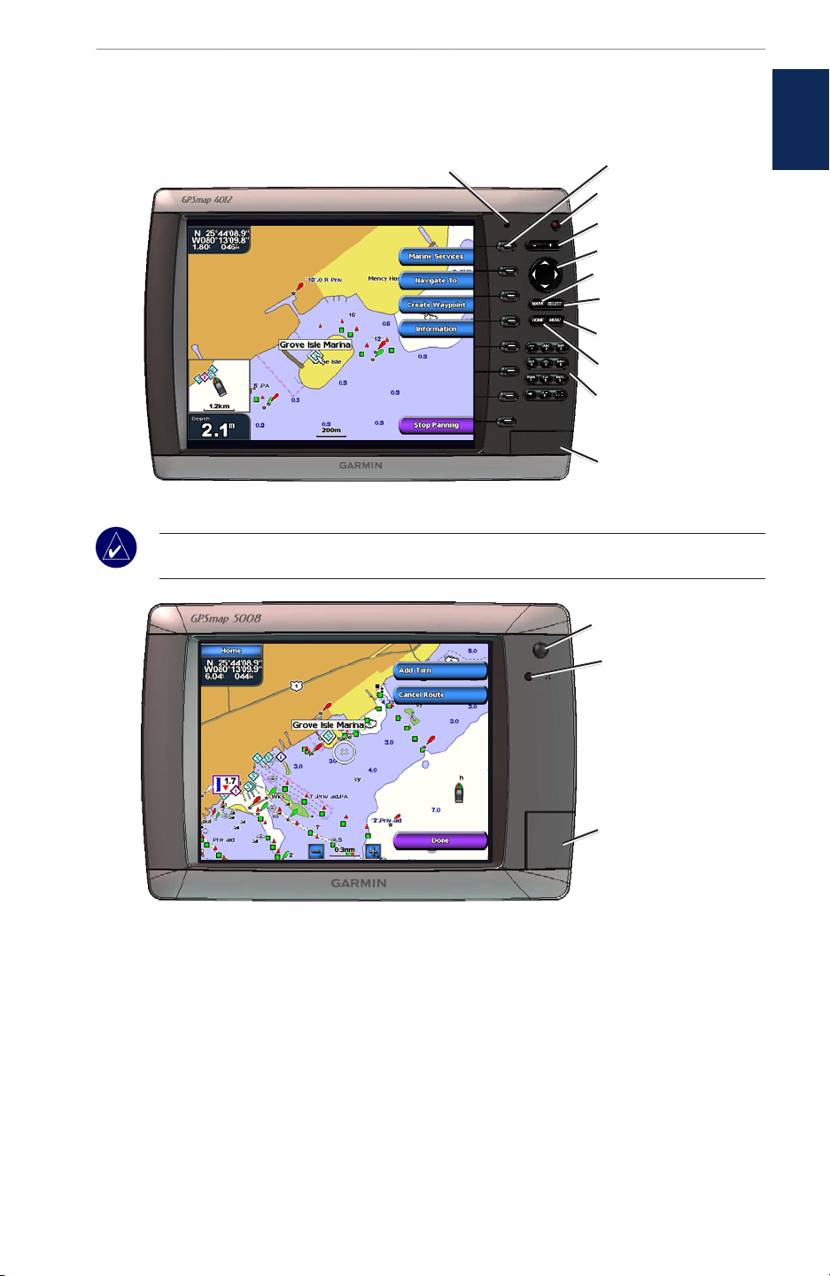
Unit Overview
Automatic backlight sensor
GPSMAP 4012
NOTE: Use the soft keys to select menu items on the GPSMAP 4008/4012 unit. Touch menu items
on the GPSMAP 5008/5012 screen to select them.
Soft keys
POWER
RANGE (+/-)
ROCKER
MARK
SELECT
MENU
HOME
Numeric keypad
(GPSMAP 4012)
SD card slot
started
GettInG
GPSMAP 5008
POWER
Automatic backlight
sensor
SD card slot
GPSMAP® 4000/5000 Series Owner’s Manual 1
GettInG Started
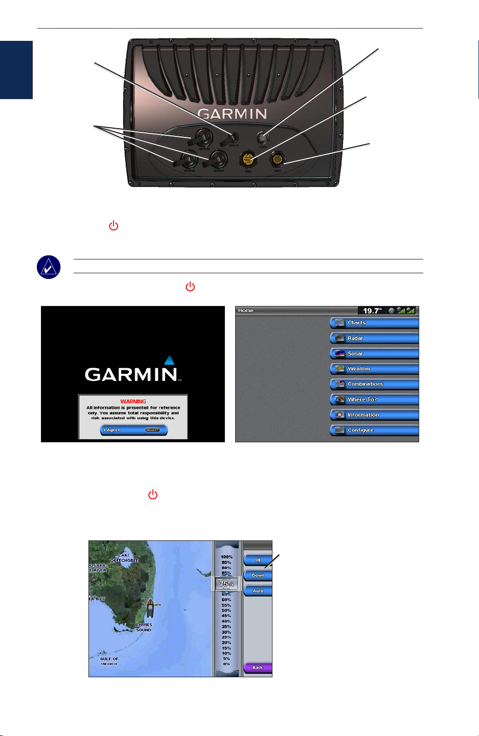
NMEA 2000
connector
GettInG
started
Garmin Marine
Network
connectors
Turning the Unit On or Off
Press and hold the POWER key until the Garmin screen appears. When the Warning screen
appears, select I Agree to open the Home screen.
NOTE: The rst time you power on your unit, you must go through a setup sequence. See page 42.
To turn the unit off, press and hold the POWER key.
Power
connector
Marine video
connector
NMEA 0183
connector
Warning Screen Home Screen
Adjusting the Backlight
1. Press and release the POWER key.
2. Select Backlight.
3. To allow the unit to automatically adjust the backlight based on ambient light, select Auto.
To manually adjust the
backlight, either select
Up or Down, or use the
ROCKER.
2 GPSMAP® 4000/5000 Series Owner’s Manual
GettInG Started
To adjust the color mode:
1. Press and release the POWER key.
2. Select Color Mode.
3. Select Day, Night, or Auto.
Acquiring GPS Satellite Signals
When you turn the unit on, the GPS receiver must collect satellite data and establish its current
location. When the unit acquires satellite signals, the signal strength bars at the top of the Home
screen are green . When the unit loses satellite signals, the green bars disappear and the
position icon shows a ashing question mark.
For more information about GPS, visit the Garmin Web site at www.garmin.com/aboutGPS.
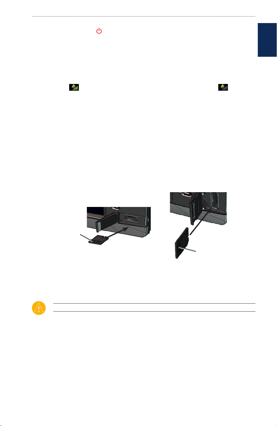
Inserting and Removing SD Cards
Your unit supports Secure Digital (SD) cards. Insert optional BlueChart
view high-resolution satellite imagery, and aerial reference photos of ports, harbors, marinas, and
other points of interest. Insert blank SD cards to transfer data such as waypoints, routes, and tracks
to another compatible Garmin unit or a computer. The SD card slot is located on the bottom-right
corner of the unit.
To insert the SD card, open the access door and press the SD card in until it clicks. Press in again to
eject the SD card.
®
g2 Vision™ SD cards to
started
GettInG
Card label
GPSMAP 4012
GPSMAP 4008/5008/5012
Card label
Restoring Factory Settings
You can restore your unit to the original factory settings.
CAUTION: This procedure deletes any information you have entered.
To restore factory settings:
1. From the Home screen, select Congure > System > System Information.
2. Select Factory Settings.
3. Select Reset to restore all factory settings. Otherwise, select Back to cancel.
Viewing System Information
You can view your unit’s software version, basemap version, and unit ID number. You may need this
information to update the system software or purchase additional map data information.
From the Home screen, select Congure > System > System Information.
GPSMAP® 4000/5000 Series Owner’s Manual 3
GettInG Started
Using Simulator Mode
Simulator Mode turns the GPS receiver off for use indoors or for practice. The unit does not track
satellites in simulator mode.
GettInG
started
CAUTION: Do not try to navigate using Simulator Mode because the GPS receiver is turned off.
Any satellite signal strength bars shown are only simulations and do not represent the strength of
actual satellite signals.
To turn on Simulator Mode
1. From the Home screen select Congure > System > Simulator > On.
2. Select Setup to set speed, track control, position, simulator time, and simulator date.
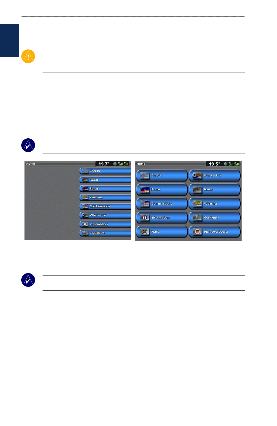
Understanding the Home Screen
Use the Home screen to access all other screens. Press or touch HOME from any screen to return to
the Home screen.
NOTE: Options on this screen vary based on the unit type. When you add additional hardware to
your Garmin Marine Network, additional options appear.
GPSMAP 4008/4012 Home Screen GPSMAP 5008/5012 Home Screen
Charts—access Navigation, Mariner’s Eye, Mariner’s Eye 3D, Fish Eye 3D, Fishing Charts
•
and Radar Overlay charts (page 5).
NOTE: Mariner’s Eye 3D, Fish Eye 3D, and Fishing Charts are available only if you use a
BlueChart g2 Vision SD card.
Radar—set up and view radar (page 33).
•
Sonar—access sonar information (page 37).
•
Combinations—set up the screen to view a chart, sonar, radar, and video in a two or three
•
(GPSMAP 4008/4012), or four (GPSMAP 5008/5012) eld split screen (page 21).
•
Where To
Information—view information including tides, currents, celestial data, user data,
•
—access navigation features (page 23).
information about other boats, gauges, and video (page 29).
Congure—access unit and system settings (page 35).
•
Mark—mark, edit, or delete your current location as a waypoint or MOB
•
(GPSMAP 5008/5012).
Man Overboard—navigate to a Man Overboard location (GPSMAP 5008/5012).
•
4 GPSMAP® 4000/5000 Series Owner’s Manual
uSInG chartS
usInG charts
Your unit has a basic worldwide imagery map. By purchasing an optional Blue Chart® g2 Vision™
preprogrammed SD card, you can view detailed information for your region, including:
Navigation Chart—displays all relevant navigation data available, including buoys, lights,
•
cables, depth soundings, marinas, and tide stations in an overhead view.
Mariner’s Eye—a view from above and behind your boat for a visual navigation aid.
•
Fishing Chart—removes navigational data from the chart, while enhancing bottom contours
•
for depth recognition.
Fish Eye 3D—an underwater view that visually represents the sea oor according to the
•
chart’s information.
The unit automatically shows relevant navigational data when you select a navigation option..
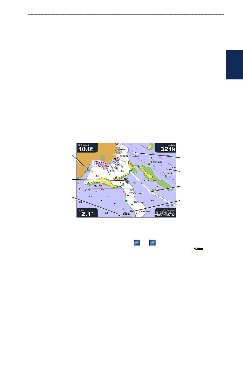
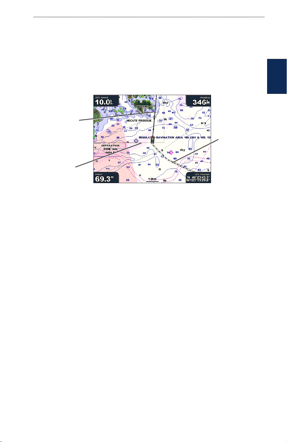
Using the Navigation Chart
Use the Navigation Chart to plan your course, view map information, and as a navigational aid.
To access the Navigation Chart, from the Home screen, select Charts > Navigation Chart.
charts
usInG
Marine
services
Your boat
Submerged
wreck
Navigation Chart with BlueChart g2 Vision Data
Exposed
wreck
Beacon
Buoy
Zoom scale
Zooming In and Out on the Map
The RANGE (+/-) keys (GPSMAP 4008/4012) or the and keys (GPSMAP 5008/5012)
control the zoom level, indicated by the scale at the bottom of the navigation chart ( ). The
bar under the number represents that distance on the map.
Navigation Chart Settings
To access additional settings or options for the Navigation chart, press or touch MENU.
Overlay Numbers—show or hide cruising, navigation, shing and sailing numbers on the screen.
Chart Setup—customize the Navigation chart.
Understanding Chart Data
BlueChart g2 and BlueChart g2 Vision charts use graphic symbols to denote map features, which
follow the standards for US and international charts.
Other features common to most charts include depth contour lines (with deep water represented in
white), intertidal zones, spot soundings (as depicted on the original paper chart), navigational aids
and symbols, and obstructions and cable areas.
GPSMAP® 4000/5000 Series Owner’s Manual 5
uSInG chartS
Navigating to a Point on the Chart
1. From the Home screen, select Charts.
2. Select Navigation Chart, Fishing Chart, or Radar Overlay.
3. Select the point on the chart where you want to go.
4. Select Navigate To.
5. Select Go To or Guide To (available when using a preprogrammed BlueChart g2 Vision card
usInG
charts
to use Auto Guidance).
6. Follow the colored line on the screen to the destination.
To create a route to a point on the chart, see page 21.
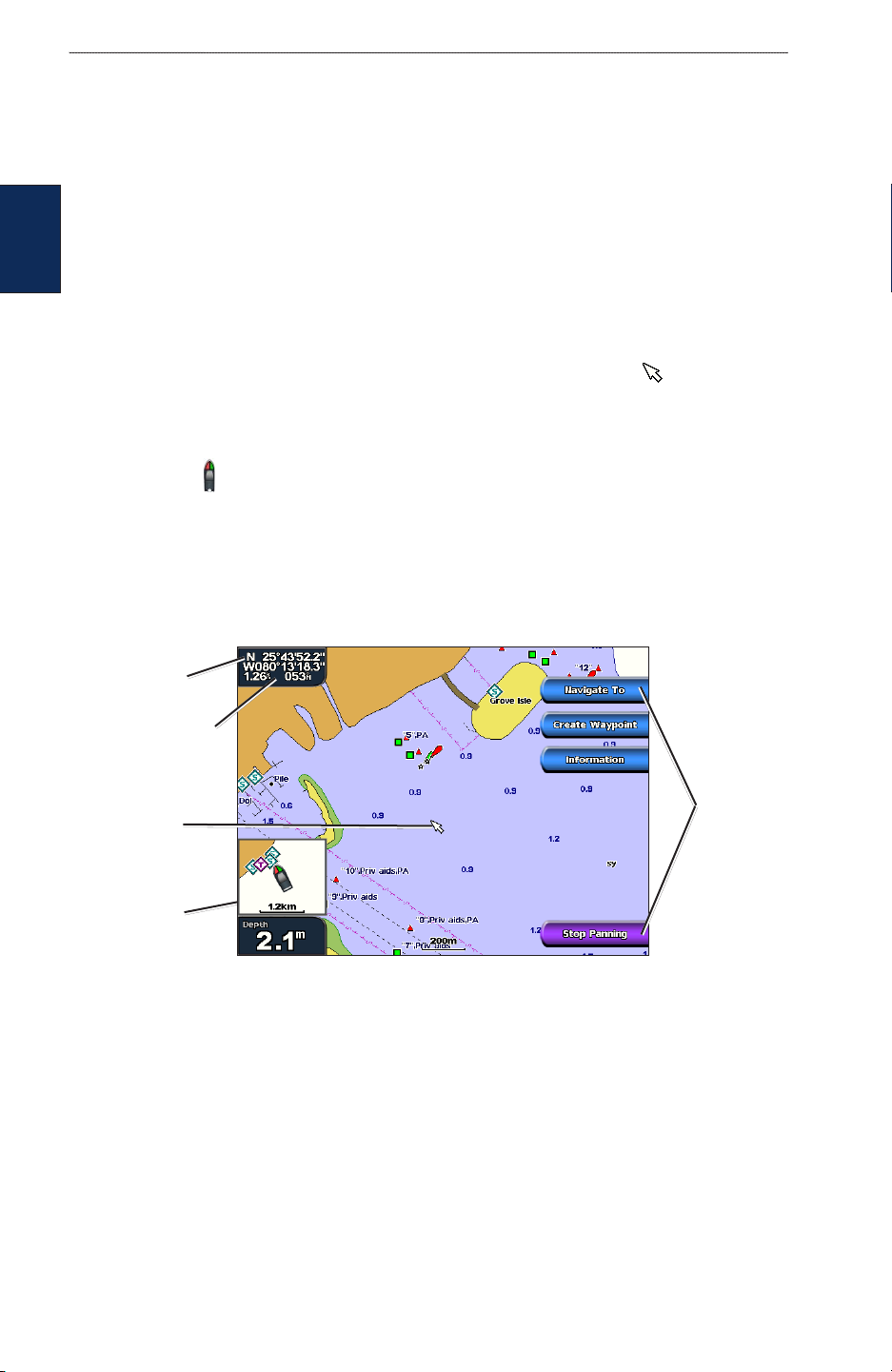
Panning the Navigation Chart
Use the ROCKER on your GPSMAP 4008/4012 unit to move the map pointer ( ) away from your
current location, and scroll to other areas on the navigation chart. As you pan past the edge of the
current map display, the screen scrolls forward to provide continuous map coverage. Touch and drag
the Navigation screen on your GPSMAP 5008/5012 unit to pan away from your current location.
The position icon ( ) stays at your present location. If the position icon leaves the map when you
pan, a small window appears in the corner so you can keep track of your current position.
As you move the map pointer, its coordinates, distance, and bearing from your current location
appear in the upper-left corner of the map.
To pan the map, press up, down, right, or left on the ROCKER (GPSMAP 4008/4012), or touch
and drag the Navigation screen (GPSMAP 5008/5012).
Pointer
coordinates
Pointer distance
and bearing
from current
location
Map
pointer
Position
window
To stop panning, select Stop Panning.
Pan
options
As you pan the map, a list of options appear along the right side. The options change as you move
the map pointer over various objects and charts.
Review—(might not appear if the pointer is not near an object—if the pointer is near only one
•
object, the object’s name appears.) This allows you to view details of objects in the vicinity of
the pointer. When you select Review, you are presented with a list of all the objects near the
pointer.
Navigate To—begin navigation to the pointer location.
•
Create Waypoint—mark a waypoint at the pointer location.
•
Information—view tide, current, celestial, or chart information near the pointer location.
•
6 GPSMAP® 4000/5000 Series Owner’s Manual
uSInG chartS
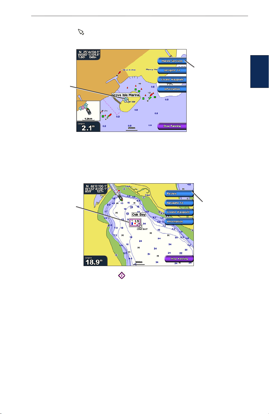
Accessing Additional Object Information
Use the map pointer ( ) (GPSMAP 4008/4012) or touch an item on the screen
(GPSMAP 5008/5012) to view information about on-screen map items, waypoints, and charts.
Additional item
information
Selected
item
Viewing Tide Station Information
Tide station information appears on the chart with a detailed icon showing the relevant tide level.
You can view an in-depth graph for a tide station to help predict the tide level at different times or
different days.
charts
usInG
Relevant tide
level
Detailed
tide station
information
Highlight or touch a tide station icon ( ), and select Review to view a detailed tide graph.
GPSMAP® 4000/5000 Series Owner’s Manual 7
uSInG chartS
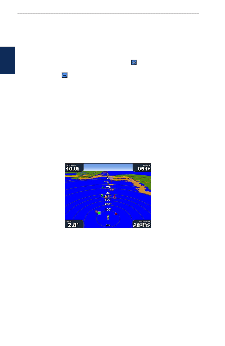
Using Mariner’s Eye
Mariner’s Eye provides a view from above and behind the boat (according to your course), and
provides a visual navigation aid. This view is helpful when navigating tricky shoals, reefs, bridges,
or channels, and is benecial when trying to identify entry and exit routes in unfamiliar harbors or
anchorages.
To access the Mariner’s Eye screen, from the Home screen, select Charts > Mariner’s Eye.
Press the RANGE (+) key (GPSMAP 4008/4012) or touch the key (GPSMAP 5008/5012) to
usInG
charts
move the view closer to your boat and lower to the water, Press the RANGE (-) key (GPSMAP
4008/4012) or touch the key (GPSMAP 5008/5012) to move the view away from the boat.
Mariner’s Eye Settings
To access additional settings or options from the Mariner’s Eye screen, press MENU.
Rings—toggle the range rings on or off.
Tracks
—turn the visible track log on or off. The unit continues to record tracks if you turn this
setting off, but they are hidden from view.
Safe Depth—adjust your boat’s safe depth.
Lane Width—adjust the width of the course line drawn when navigating. This setting does not
affect routes (Route To) or automatic guidance (Guide To).
Show Radar—
If you have a Garmin marine radar device connected to your Garmin Marine
Network, you can overlay radar readings on the Mariner’s Eye screen.
Mariner’s Eye With Radar Information
Overlay Numbers—show or hide cruising, navigation, shing, and sailing numbers.
8 GPSMAP® 4000/5000 Series Owner’s Manual
Changing the Chart Settings
To change chart settings, from the Home screen, select Charts > Chart Setup.
Orientation—change the perspective of the map display:
North Up—sets the top of the map display to a north heading.
•
Track Up—sets the map display to the current track heading.
•
Course Up—sets the map so the direction of navigation is always up. The heading line
•
appears vertically on the screen if shown.
Heading line
Chart border
Track
uSInG chartS
charts
usInG
Heading Line—draws an extension from the bow of the boat in the direction of travel.
Off—turns off the heading line.
•
Distance—sets the distance to the end of the heading line.
•
•
—sets the amount of time until you reach the end of the heading line.
Time
Chart Borders—turn on chart borders when using a BlueChart g2 Vision SD card and you want to
see what area the maps cover.
Tracks
—hides (off) or shows (on) tracks on the chart.
Inset Map—turn the inset map on or off when panning away.
Appearance—customizes how items are shown on the map.
Changing the Chart Appearance
From the Home screen, select Charts > Chart Setup > Appearance.
Detail—adjust the amount of detail shown on the map at different zoom levels.
Photos—set the high resolution satellite images to on, off, or land only. High-resolution satellite
imagery is only available while using a BlueChart g2 Vision SD card.
Spot Depths—turn on spot soundings and set a dangerous depth.
Light Sectors—adjust the drawing of light sectors on the map.
Symbols—select the navaid symbol set (NOAA or IALA).
Symbol Size—adjust the size of the symbols shown on the map.
GPSMAP® 4000/5000 Series Owner’s Manual 9
uSInG chartS
Using BlueChart g2 Vision
Optional BlueChart g2 Vision preprogrammed SD cards allow you to get the most out of your unit.
In addition to detailed marine charting, BlueChart g2 Vision has the following features:
Mariner’s Eye 3D—a view from above and behind the boat, for a visual, three-dimensional
•
navigation aid. The BlueChart g2 Vision Mariner’s Eye 3D is more detailed than the
preloaded data.
Fish Eye 3D—an underwater, 3D view that visually represents the sea oor according to the
charts
•
chart’s information.
Fishing Charts—view the chart with enhanced bottom contours and without navigational
•
data. This chart works best for offshore deep-sea shing.
High Resolution Satellite Imagery—high resolution satellite images are provided for a
•
realistic view of the land and water on the Navigation chart.
Aerial Photos—view marinas and other navigationally signicant aerial photos to help you
•
visualize your surroundings.
Detailed Roads and POI data—view roads, restaurants, and other points of interest (POIs)
•
along the shore.
Current Data—view current station information.
•
Auto Guidance—uses the specied boat safe depth and chart data to determine the best
•
course to your destination.
usInG
NOTE: You cannot transfer BlueChart g2 Vision data from the SD card to your computer for
backup or viewing purposes. You can only use the SD card on BlueChart g2 Vision compatible
Garmin GPS units.
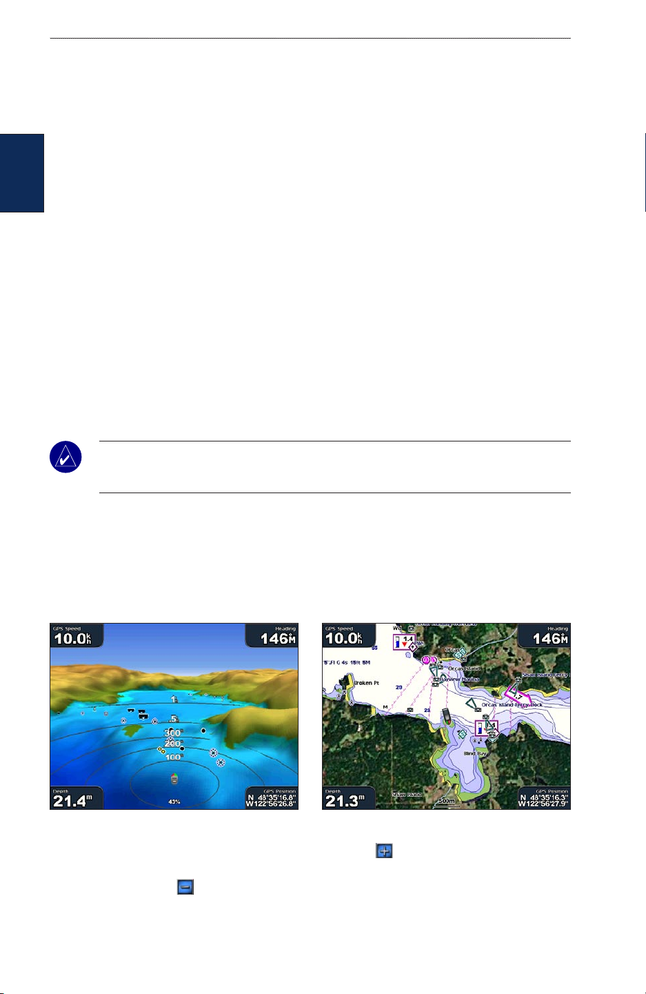
Using Mariner’s Eye 3D
A BlueChart g2 Vision SD card offers Mariner’s Eye 3D, which provides a detailed threedimensional view from above and behind the boat (according to your course), and provides a visual
navigation aid. This view is helpful when navigating tricky shoals, reefs, bridges, or channels, and is
benecial when trying to identify entry and exit routes in unfamiliar harbors or anchorages.
Mariner’s Eye 3D Navigation Chart
Press the RANGE (+) key (GPSMAP 4008/4012) or touch the key (GPSMAP 5008/5012) to
move the view closer to your boat and lower to the water, Press the RANGE (-) key (GPSMAP
4008/4012) or touch the key (GPSMAP 5008/5012) to move the view away from the boat.
10 GPSMAP® 4000/5000 Series Owner’s Manual
uSInG chartS
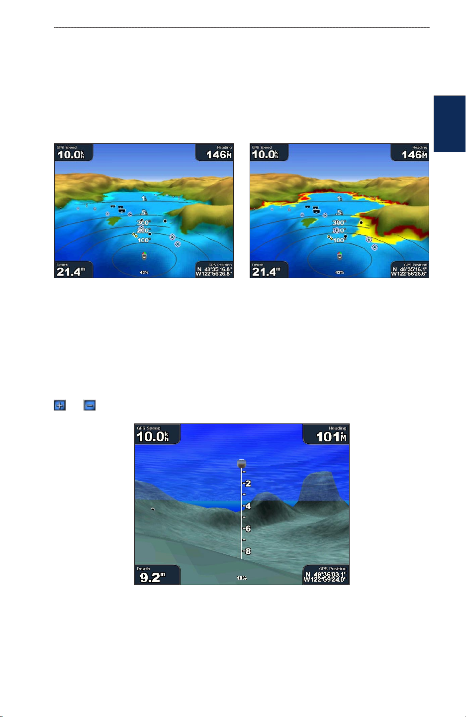
Mariner’s Eye 3D Settings
To access additional settings or options from the Mariner’s Eye 3D screen, press MENU.
Colors —choose between Normal (Default), Water Hazard, and All Hazard. The Normal setting
shows the land as seen from the water. The Water Hazard setting indicates shallow water and land
with a color scale. Blue indicates deep water, yellow is shallow water, and red is very shallow. The
Water Hazard setting indicates land in green and brown, and the All Hazard setting shows land as
dark red.
Mariner’s Eye 3D, Normal Colors Mariner’s Eye 3D, Hazard Colors
Safe Depth—adjust the depth at which red indicates shallow water. This also changes the global
Safe Depth setting as it applies to the Auto Guidance feature.
charts
usInG
Rings, Tracks, Lane Width, and Show Radar—see “Mariner’s Eye Settings” on page 8.
Using Fish Eye 3D
Using the depth contour lines of the BlueChart g2 Vision cartography, Fish Eye 3D provides an
underwater view of the sea oor or lake bottom. Use the RANGE keys (GPSMAP 4008/4012) or the
and keys (GPSMAP 5008/5012) to adjust the view.
Fish Eye 3D
GPSMAP® 4000/5000 Series Owner’s Manual 11
uSInG chartS
Fish Eye 3D Settings
To access additional settings or options for the Fish Eye 3D screen, press MENU.
Sonar Cone—turn a cone on or off that shows the area covered by your transducer.
Sonar Data—visually show the sonar readings received by your transducer for the best combination
of sonar and mapping.
Tracks
usInG
charts
—turn the track log on or off.
Overlay Numbers—show or hide cruising, navigation, or shing numbers.
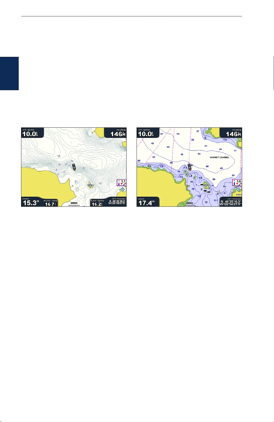
Using Fishing Charts
Use the Fishing chart for a detailed, unobstructed view of the bottom contours and depth soundings
on the chart.
Fishing Chart Navigation Chart
The Fishing chart uses detailed bathymetric data on a preprogrammed BlueChart g2 Vision SD card,
and is best for offshore deep-sea shing.
12 GPSMAP® 4000/5000 Series Owner’s Manual

uSInG chartS
Enabling High Resolution Satellite Imagery
You can overlay high-resolution satellite images on the land, sea, or both portions of the Navigation
chart when using a preprogrammed BlueChart g2 Vision SD card.
To enable satellite imagery:
1. While viewing the Navigation Chart, press MENU.
2. Select Chart Setup > Appearance > Photos.
3. Select one of the following:
Off—standard chart information is shown on the map.
•
Land Only—standard chart information is shown on water with photos overlaying the land.
•
On—photos overlay both the water and the land at a specied opacity. The higher you set
•
the percentage, the more the satellite photos will cover both land and water.
NOTE: When enabled, the high resolution satellite images are only present at lower zoom levels.
If you cannot see the high resolution images in your BlueChart g2 Vision region, either zoom in
further using the RANGE (+) key (GPSMAP 4008/4012) or touch the key
(GPSMAP 5008/5012), or set the detail level higher.
charts
usInG
Photo Overlay Off Land Only Photo Overlay
Photo Overlay at 50%
GPSMAP® 4000/5000 Series Owner’s Manual 13
Photo Overlay at 100%
 Loading...