

Garmin Fleet 770 Owner’s Manual
GARMIN FLEET™ 770
Owner’s Manual

© 2017 Garmin Ltd. or its subsidiaries
All rights reserved. Under the copyright laws, this manual may not be copied, in whole or in part, without the written consent of Garmin. Garmin reserves the right to change or improve its
products and to make changes in the content of this manual without obligation to notify any person or organization of such changes or improvements. Go to www.garmin.com for current updates
and supplemental information concerning the use of this product.
Garmin® and the Garmin logo are trademarks of Garmin Ltd. or its subsidiaries, registered in the USA and other countries. These trademarks may not be used without the express permission of
Garmin.
Garmin fleet™, Garmin Express™, myTrends™, are trademarks of Garmin Ltd. or its subsidiaries. These trademarks may not be used without the express permission of Garmin.
The Bluetooth® word mark and logos are owned by the Bluetooth SIG, Inc., and any use of such word mark or logo by Garmin is under license. HD Radio™ Technology manufactured under
license from iBiquity Digital Corporation. U.S. and Foreign Patents. For patents see http://patents.dts.com/. HD Radio™ and the HD, HD Radio, and "ARC" logos are registered trademarks or
trademarks of iBiquity Digital Corporation in the United States and/or other countries. Mac® is a trademark of Apple Inc. microSD® and the microSDHC logo are trademarks of SD-3C, LLC.
Windows® and Windows XP® are registered trademarks of Microsoft Corporation in the United States and other countries. Wi‑Fi® and Wi‑Fi CERTIFIED MiraCast™ are registered marks of Wi-Fi
Alliance Corporation.

Table of Contents
Getting Started............................................................... 1
Garmin fleet 770 Overview......................................................... 1
Mounting and Powering the Garmin fleet Device in Your
Vehicle........................................................................................ 1
Turning the Device On or Off...................................................... 1
Acquiring GPS Signals............................................................... 1
Home Screen.............................................................................. 2
Adding Shortcuts to the Home Screen.................................. 2
Viewing Notifications.............................................................. 2
Status Bar Icons.....................................................................2
Adjusting the Screen Brightness................................................ 2
Vehicle Profiles............................................................... 2
Car Profile................................................................................... 2
Adding a Vehicle Profile..............................................................2
Activating a Vehicle Profile......................................................... 2
Changing Your Trailer Information..............................................2
Editing a Vehicle Profile.............................................................. 3
Driver Awareness Features and Alerts........................ 3
Enabling or Disabling Audible Driver Alerts................................ 3
Red Light and Speed Cameras.................................................. 3
Navigating to Your Destination..................................... 3
Routes........................................................................................ 3
Starting a Route.......................................................................... 3
Starting a Route by Using the Map........................................ 4
Going Home........................................................................... 4
Your Route on the Map...............................................................4
Active Lane Guidance............................................................ 4
Viewing Turns and Directions................................................ 4
Viewing the Entire Route on the Map.................................... 4
Arriving at Your Destination........................................................ 4
Parking Near Your Destination.............................................. 4
Finding Your Last Parking Spot............................................. 5
Changing Your Active Route...................................................... 5
Adding a Location to Your Route........................................... 5
Shaping Your Route...............................................................5
Taking a Detour..................................................................... 5
Changing the Route Calculation Mode.................................. 5
Stopping the Route..................................................................... 5
Using Suggested Routes............................................................ 5
Avoiding Delays, Tolls, and Areas.............................................. 5
Avoiding Traffic Delays on Your Route.................................. 5
Avoiding Toll Roads............................................................... 5
Avoiding Toll Stickers.............................................................6
Avoiding Road Features........................................................ 6
Avoiding Environmental Zones.............................................. 6
Custom Avoidances............................................................... 6
Finding and Saving Locations...................................... 6
Points of Interest......................................................................... 6
Finding Trucking Points of Interest............................................. 6
Finding TruckDown Points of Interest.................................... 6
Finding a Location Using the Search Bar................................... 7
Finding a Location by Category.................................................. 7
Searching Within a Category................................................. 7
Location Search Results............................................................. 7
Location Search Results on the Map..................................... 7
Changing the Search Area......................................................... 7
Custom Points of Interest........................................................... 7
Installing POI Loader............................................................. 7
Finding Custom POIs............................................................. 7
Parking........................................................................................7
Finding Truck Parking............................................................ 8
Finding Parking Near Your Current Location......................... 8
Understanding Parking Colors and Symbols......................... 8
Search Tools
Finding an Address................................................................ 8
Finding an Intersection...........................................................8
Finding a City......................................................................... 8
Finding a Location Using Coordinates................................... 8
Viewing Recently Found Locations............................................ 8
Clearing the List of Recently Found Locations...................... 8
Viewing Current Location Information........................................ 8
Finding Emergency Services and Fuel.................................. 8
Getting Directions to Your Current Location.......................... 8
Adding a Shortcut....................................................................... 8
Removing a Shortcut............................................................. 8
Saving Locations........................................................................ 8
Saving a Location.................................................................. 8
Saving Your Current Location................................................ 8
Editing a Saved Location....................................................... 9
Assigning Categories to a Saved Location............................ 9
Deleting a Saved Location..................................................... 9
...............................................................................8
Using the Map................................................................. 9
Map Tools................................................................................... 9
Viewing a Map Tool............................................................... 9
Enabling Map Tools............................................................... 9
Up Ahead.................................................................................... 9
Viewing Upcoming Locations................................................. 9
Customizing the Up Ahead Categories.................................. 9
Warning and Alert Symbols...................................................... 10
Restriction Warnings............................................................ 10
Road Condition Warnings.................................................... 10
Alerts.................................................................................... 10
Trip Information.........................................................................10
Viewing Trip Data from the Map.......................................... 10
Viewing the Trip Information Page....................................... 10
Viewing the Trip Log............................................................ 10
Resetting Trip Information....................................................10
Viewing Upcoming Traffic......................................................... 10
Viewing Traffic on the Map.................................................. 10
Searching for Traffic Incidents............................................. 10
Customizing the Map................................................................ 10
Customizing the Map Layers............................................... 10
Changing the Map Data Field.............................................. 10
Changing the Map Perspective............................................ 10
Hands-Free Calling....................................................... 11
Pairing Your Phone...................................................................11
Placing a Call............................................................................ 11
Receiving a Call........................................................................ 11
Using In-Call Options................................................................ 11
Saving a Phone Number as a Preset....................................... 11
Deleting a Paired Phone........................................................... 11
Traffic............................................................................ 11
Receiving Traffic Data Using a Traffic Receiver....................... 11
Traffic Receiver Subscriptions............................................. 11
Viewing Traffic on the Map....................................................... 12
Searching for Traffic Incidents............................................. 12
Using the Apps............................................................. 12
Viewing the Owner's Manual on Your Device........................... 12
Viewing the Truck Map............................................................. 12
IFTA.......................................................................................... 12
Entering Fuel Data............................................................... 12
Editing Fuel Data................................................................. 12
Viewing and Exporting a Jurisdiction Summary................... 12
Editing and Exporting Trip Reports...................................... 12
Viewing Exported Jurisdiction Summaries and Trip
Reports................................................................................ 12
Logging Service History............................................................ 12
Adding Service Categories.................................................. 13
Table of Contents i

Deleting Service Categories................................................ 13
Renaming Service Categories............................................. 13
Deleting Service Records.................................................... 13
Editing a Service Record..................................................... 13
Trip Planner.............................................................................. 13
Planning a Trip..................................................................... 13
Editing and Reordering Locations in a Trip.......................... 13
Discovering Attractions Along Your Trip.............................. 13
Changing Routing Options for a Trip................................... 13
Navigating to a Saved Trip...................................................13
Editing and Saving Your Active Route................................. 13
Viewing Previous Routes and Destinations.............................. 14
Viewing the Weather Forecast..................................................14
Viewing Weather Near a Different City................................ 14
Garmin fleet Settings................................................... 14
Navigation Settings................................................................... 14
Map and Vehicle Settings.................................................... 14
Route Preference Settings................................................... 14
Driver Assistance Settings................................................... 14
Traffic Settings..................................................................... 14
Connecting to a Wireless Network............................................14
Display Settings........................................................................ 14
Sound and Notification Settings............................................... 15
Adjusting Sound and Notification Volume............................ 15
Setting the Text Language....................................................... 15
Adding Accounts....................................................................... 15
Date and Time Settings............................................................ 15
Device Settings......................................................................... 15
Restoring Settings.................................................................... 15
Device Information....................................................... 15
Viewing Regulatory and Compliance Information..................... 15
Specifications............................................................................15
Charging the Device................................................................. 15
Device Maintenance..................................................... 15
Garmin Support Center.............................................................15
Updating Maps and Software Using a Wi‑Fi Network.............. 15
Device Care.............................................................................. 16
Cleaning the Outer Casing...................................................16
Cleaning the Touchscreen................................................... 16
Avoiding Theft...................................................................... 16
Changing the Fuse in the Vehicle Power Cable....................... 16
Resetting the Device.................................................................16
Removing the Device, Mount, and Suction Cup....................... 16
Removing the Mount from the Suction Cup......................... 16
Removing the Suction Cup from the Windshield................. 16
Troubleshooting........................................................... 16
The suction cup will not stay on my windshield........................ 16
My device is not acquiring satellite signals............................... 16
The device does not charge in my vehicle............................... 17
My battery does not stay charged for very long........................ 17
My phone will not connect to the device................................... 17
Appendix....................................................................... 17
Connecting to a Wireless Display............................................. 17
Data Management.................................................................... 17
About Memory Cards........................................................... 17
Installing a Memory Card for Maps and Data...................... 17
Connecting the Device to Your Computer........................... 17
Transferring Data From Your Computer.............................. 17
Purchasing Additional Maps..................................................... 17
Purchasing Accessories........................................................... 17
Index.............................................................................. 18
ii Table of Contents

Getting Started
WARNING
See the Important Safety and Product Information guide in the
product box for product warnings and other important
information.
• Update the maps and software on your device (Updating
Maps and Software Using a Wi‑Fi Network, page 15).
• Mount the device in your vehicle and connect it to power
(Mounting and Powering the Garmin fleet Device in Your
Vehicle, page 1).
• Acquire GPS signals (Acquiring GPS Signals, page 1).
• Adjust the volume (Adjusting Sound and Notification Volume,
page 15) and display brightness (Adjusting the Screen
Brightness, page 2).
• Set up a vehicle profile (Adding a Vehicle Profile, page 2).
• Navigate to your destination (Starting a Route, page 3).
Garmin fleet 770 Overview
NOTICE
Both the device and its mount contain magnets. Under certain
circumstances, magnets may cause damage to some electronic
devices, including hard drives in laptop computers. Use caution
when the device or its mount is near electronic devices.
Before you use your device on battery power, you should charge
it.
Plug the vehicle power cable À into the mini-USB port on the
1
mount.
Press the mount Á onto the suction cup  until it snaps into
2
place.
NOTE: The mount and suction cup may already be
assembled in the package.
The Garmin® logo on the mount should face right-side up. It is
easiest to connect the mount and suction cup when the
hinged arm on the suction cup is closed. The mount and
suction cup fit tightly, and you may need to press hard to
connect them.
Press the suction cup to the windshield, and flip the lever
3
back toward the windshield.
Place the back of the device onto the magnetic mount.
4
Select an option:
5
• If your power cable has a vehicle power plug, plug it into a
power outlet in your vehicle.
• If your power cable has bare wire connectors, follow the
wiring diagram included with your cable to connect the
cable to vehicle power.
Ã
Microphone for hands-free calling
À
Volume control
Á
Power key
Â
Micro USB power and data port
Ã
Map and data memory card slot
Ä
3.5mm audio jack
Å
Magnetic mount interface with 14 pin connector
Æ
Speaker
Ç
Mounting and Powering the Garmin fleet Device in Your Vehicle
WARNING
This product contains a lithium-ion battery. To prevent the
possibility of personal injury or product damage caused by
battery exposure to extreme heat, store the device out of direct
sunlight.
Both the device and its mount contain magnets. Under certain
circumstances, magnets may cause interference with some
internal medical devices, including pacemakers and insulin
pumps. Keep the device and its mount away from such medical
devices.
Turning the Device On or Off
• To turn the device on, press the power key, or connect the
device to power.
• To put the device in power saving mode, press the power key
while the device is on.
While in power saving mode, the screen is off and the device
uses very little power, but it can wake instantly for use.
TIP: You can charge your device faster by putting it in power
saving mode while charging the battery.
• To turn off the device completely, hold the power key until a
prompt appears on the screen, and select Off.
The prompt appears after five seconds. If you release the
power key before the prompt appears, the device enters
power saving mode.
Acquiring GPS Signals
When you turn on your navigation device, the GPS receiver
must collect satellite data and establish the current location. The
time required to acquire satellite signals varies based on several
factors, including how far you are from the location where you
last used your navigation device, whether you have a clear view
of the sky, and how long it has been since you last used your
navigation device. The first time you turn on your navigation
device, it may take several minutes to acquire satellite signals.
Turn on the device.
1
Getting Started 1
Wait while the device locates satellites.
2
If necessary, go to an open area, away from tall buildings and
3
trees.
in the status bar indicates the device has established your
location.
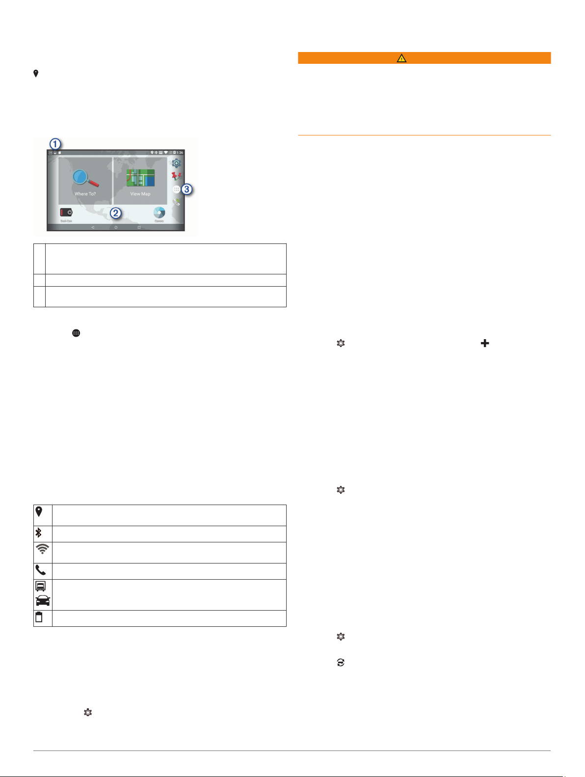
Home Screen
NOTE: The home screen and customization options may vary
based on configuration by your fleet management company.
Swipe down to view notifications.
À
Swipe down twice to quickly change settings and backlight
brightness.
Hold to customize the wallpaper or add widgets to the home screen.
Á
Select to open the app drawer. The app drawer contains shortcuts
Â
to all the apps installed on your device.
Adding Shortcuts to the Home Screen
Select .
1
Swipe up or down to view additional applications.
2
Hold an application, and drag it to a location on the home
3
screen.
Viewing Notifications
Swipe down from the top of the screen.
1
The list of notifications appears.
Select an option:
2
• To launch the action or app mentioned in the notification,
select the notification.
• To dismiss a notification, swipe the notification to the right.
Status Bar Icons
The status bar is located at the top of the main menu. The status
bar icons display information about features on the device.
The device has acquired GPS satellites and established your
location (Acquiring GPS Signals, page 1).
Bluetooth® technology is enabled.
Connected to a Wi‑Fi® network (Connecting to a Wireless
Network, page 14).
Connected to hands-free calling (Hands-Free Calling, page 11).
Active vehicle profile. Swipe down twice and select to view the
vehicle profile settings (Vehicle Profiles, page 2).
Battery charge level.
Adjusting the Screen Brightness
You can adjust the brightness using either the notification panel
or the settings menu.
Select an option:
1
• Swipe down twice from the top of the screen to expand
the quick settings in the notification panel.
• Select > Display > Brightness Level.
Use the slider bar to adjust the brightness.
2
Vehicle Profiles
WARNING
Entering your vehicle profile characteristics does not guarantee
that your vehicle's characteristics will be accounted for in all
route suggestions or that you will receive the warning icons in all
cases. Limitations may exist in the map data such that your
device cannot account for these restrictions or road conditions in
all cases. Always defer to all posted road signs and road
conditions when making driving decisions.
Routing and navigation are calculated differently based on your
vehicle profile. The activated vehicle profile is indicated by an
icon in the status bar. The navigation and map settings on your
device can be customized separately for each vehicle type.
When you activate a truck vehicle profile, the device avoids
including restricted or impassable areas in routes based on the
dimensions, weight, and other characteristics you entered for
your vehicle.
Car Profile
The car profile is a preloaded vehicle profile intended for use in
an automobile. While using the car profile, the device calculates
standard automobile routes, and truck routing is not available.
Some truck-specific features and settings are not available while
using the car profile.
Adding a Vehicle Profile
You can add a vehicle profile that includes the weight,
dimensions, and other characteristics for your vehicle.
Select > Navigation > Vehicle Profile > .
1
Select an option:
2
• To add a straight truck with a permanently attached cargo
area, select Straight Truck.
• To add a tractor or a tractor-trailer combination, select
Tractor.
Follow the on-screen instructions to enter the vehicle
3
characteristics.
After you add a vehicle profile, you can edit the profile to enter
additional detailed information, such as the vehicle identification
number or trailer number.
Activating a Vehicle Profile
Select > Navigation > Vehicle Profile.
1
Select a vehicle profile.
2
The vehicle profile information appears, including
measurements and weight.
Select Select.
3
Changing Your Trailer Information
Before you can change your trailer information, you must enter a
vehicle profile for a tractor (Adding a Vehicle Profile, page 2).
When you change the trailer on your tractor, you can change the
trailer information in your vehicle profile without changing the
tractor information. You can switch quickly between frequently
used trailers.
Select > Navigation > Vehicle Profile.
1
Select the tractor vehicle profile to use with the trailer.
2
Select .
3
Select an option:
4
• To use a recent trailer configuration, select a trailer
configuration from the list.
• To enter a new trailer configuration, select New
Configuration, and enter the trailer information.
2 Vehicle Profiles

Editing a Vehicle Profile
You can edit a vehicle profile to change vehicle information or to
add detailed information to a new vehicle profile, such as the
vehicle identification number, trailer number, or odometer
reading. You can also rename or delete a vehicle profile.
Select > Navigation > Vehicle Profile.
1
Select the vehicle profile to edit.
2
Select an option:
3
• To edit the vehicle profile information, select , and select
a field to edit.
• To rename a vehicle profile, select > > Rename
Profile.
• To delete the vehicle profile, select > > Delete.
Driver Awareness Features and Alerts
NOTICE
The driver alerts and speed limit features are for information
only and do not replace your responsibility to abide by all posted
speed limit signs and to use safe driving judgment at all times.
Garmin is not responsible for any traffic fines or citations you
receive for failing to follow all applicable traffic laws and signs.
Your device provides features that can help encourage safer
driving and increase efficiency, even when you are driving in a
familiar area. The device plays an audible tone or message and
displays information for each alert. You can enable or disable
the audible tone for some types of driver alerts. Not all alerts are
available in all areas.
Schools: The device plays a tone and displays the distance to
and speed limit (if available) for an upcoming school or
school zone.
Speed limit reduction: The device plays a tone and displays
the upcoming reduced speed limit so you can be prepared to
reduce your speed.
Speed limit exceeded: The device plays a tone and displays a
red border on the speed limit icon when you exceed the
posted speed limit for the current road.
Speed limit change: The device plays a tone and displays the
upcoming speed limit so you can be prepared to adjust your
speed.
Railroad crossing: The device plays a tone and displays the
distance to an upcoming railroad crossing.
Animal crossing: The device plays a tone and displays the
distance to an upcoming animal crossing area.
Curves: The device plays a tone and displays the distance to a
curve in the road.
Slower traffic: The device plays a tone and displays the
distance to slower traffic when you approach slower traffic at
a higher speed. Your device must be receiving traffic
information to use this feature (Traffic, page 11).
No trucks allowed: The device plays a tone when you
approach a road where no trucks are allowed.
Risk of grounding: The device plays a tone and displays a
message when you approach a road where your vehicle
could become grounded.
Lateral wind: The device plays a tone and displays a message
when you approach a road where there is risk of lateral wind.
Narrow road: The device plays a tone and displays a message
when you approach a road that may be too narrow for your
vehicle.
Steep hill: The device plays a tone and displays a message
when you approach a steep hill.
State and country borders: The device plays a tone and
displays a message when you approach the border of a state
or country.
Enabling or Disabling Audible Driver Alerts
You can enable or disable the audible tone for some types of
driver alerts. The visual alert appears even when the tone is
disabled.
Select > Navigation > Driver Assistance > Audible
1
Driver Alerts.
Select or clear the check box next to each alert.
2
Red Light and Speed Cameras
NOTICE
Garmin is not responsible for the accuracy of or the
consequences of using a red light or speed camera database.
NOTE: This feature is not available for all regions or product
models.
Information about red light and speed camera locations is
available in some areas for some product models. The device
alerts you when you approach a reported speed or red light
camera.
• To maintain an updated database of red light and speed
camera locations, your device must have an active
subscription to download and store safety camera data. Go to
garmin.com/speedcameras to check availability and
compatibility, or to purchase a subscription or one-time
update. You can purchase a new region or extend an existing
subscription at any time.
NOTE: In some regions, some product bundles include preloaded red light and speed camera data with free lifetime
updates.
• You can use the Garmin Express™ software (garmin.com
/express) to update the camera database stored on your
device. You should update your device frequently to receive
the most up-to-date camera information.
Navigating to Your Destination
Routes
A route is a path from your current location to one or more
destinations.
• The device calculates a recommended route to your
destination based on the preferences you set, including the
route calculation mode (Changing the Route Calculation
Mode, page 5) and avoidances (Avoiding Delays, Tolls,
and Areas, page 5).
• The device can automatically avoid roads that are not
appropriate for the active vehicle profile.
• You can start navigating to your destination quickly using the
recommended route, or you can select an alternate route
(Starting a Route, page 3).
• If there are specific roads you need to use or avoid, you can
customize the route (Shaping Your Route, page 5).
• You can add multiple destinations to a route (Adding a
Location to Your Route, page 5).
Starting a Route
Select Where To?, and search for a location (Finding and
1
Saving Locations, page 6).
Select a location.
2
Select an option:
3
• To start navigating using the recommended route, select
Go!.
Driver Awareness Features and Alerts 3
• To choose an alternate route, select , and select a route.
Alternate routes appear to the right of the map.
• To edit the course of the route, select > Edit Route, and
add shaping points to the route (Shaping Your Route,
page 5).
The device calculates a route to the location and guides you
using voice prompts and information on the map (Your Route on
the Map, page 4). A preview of the major roads in your route
appears at the edge of the map for several seconds.
If you need to stop at additional destinations, you can add the
locations to your route (Adding a Location to Your Route,
page 5).
Starting a Route by Using the Map
You can start route by selecting a location from the map.
Select View Map.
1
Drag and zoom the map to display the area to search.
2
If necessary, select to filter the displayed points of interest
3
by category.
Location markers ( or a blue dot) appear on the map.
Select an option:
4
• Select a location marker.
• Select a point, such as a street, intersection, or address
location.
Select Go!.
5
Going Home
The first time you start a route home, the device prompts you to
enter your home location.
Select Where To? > Go Home.
1
If necessary, enter your home location.
2
Editing Your Home Location
Select Where To? > > Set Home Location.
1
Enter your home location.
2
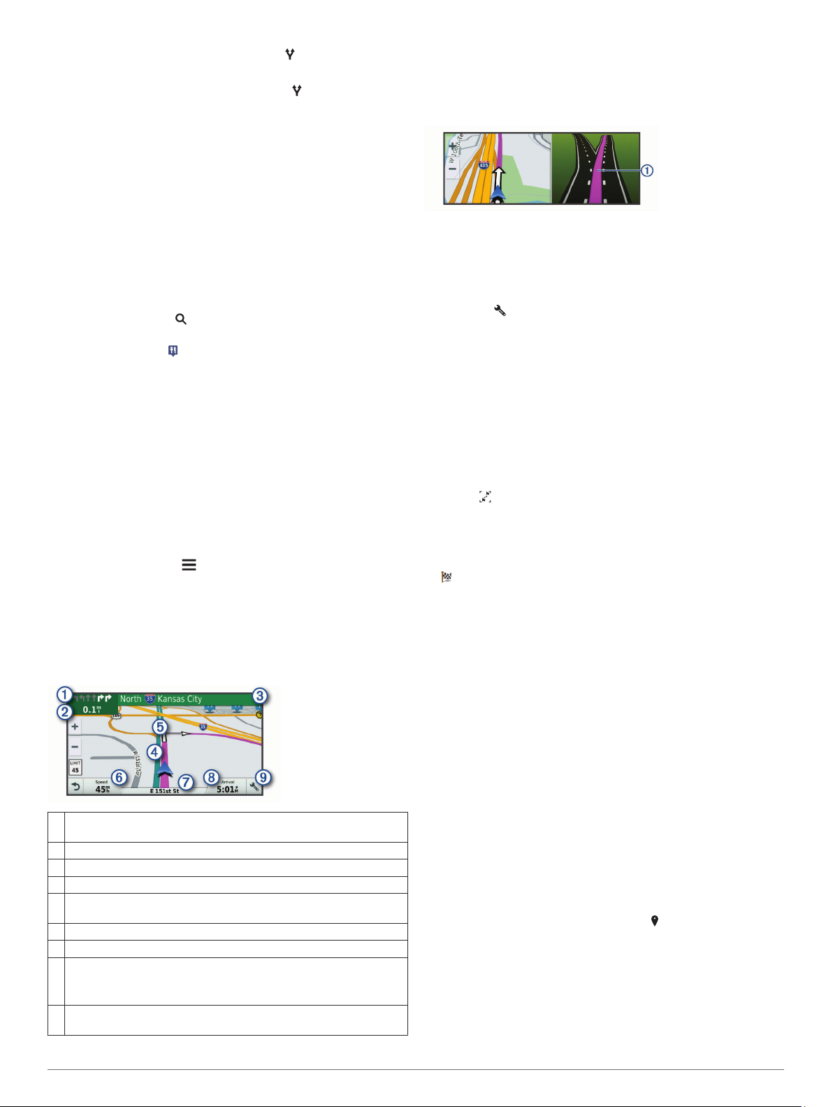
Your Route on the Map
As you travel, the device guides you to your destination using
voice prompts and information on the map. Instructions for your
next turn or exit, or other actions appear across the top of the
map.
Next action in the route. Indicates the next turn, exit, or other action
À
and the lane in which you should travel, if available.
Distance to the next action.
Á
Name of the street or exit associated with the next action.
Â
Route highlighted on the map.
Ã
Next action in the route. Arrows on the map indicate the location of
Ä
upcoming actions.
Vehicle speed.
Å
Name of the road on which you are traveling.
Æ
Estimated arrival time.
Ç
TIP: You can touch this field to change the information it shows
(Changing the Map Data Field, page 10).
Map tools. Provides tools to show you more information about your
È
route and surroundings.
Active Lane Guidance
As you approach some turns, exits, or interchanges in your
route, a detailed simulation of the road appears beside the map,
if available. A colored line À indicates the proper lane for the
turn.
Viewing Turns and Directions
While navigating a route, you can view upcoming turns, lane
changes, or other directions for your route.
From the map, select an option:
1
• To view upcoming turns and directions as you navigate,
select > Turns.
The map tool displays the next four turns or directions
beside the map. The list updates automatically as you
navigate the route.
• To view the complete list of turns and directions for the
entire route, select the text bar at the top of the map.
Select a turn or direction (optional).
2
Detailed information appears. An image of the junction may
appear for junctions on major roadways, if available.
Viewing the Entire Route on the Map
While navigating a route, select anywhere on the map.
1
Select .
2
Arriving at Your Destination
When you approach your destination, the device provides
information to help you complete your route.
• indicates the location of your destination on the map, and a
voice prompt announces you are approaching your
destination.
• When you approach some destinations, the device
automatically prompts you to search for parking. You can
select Yes to find nearby parking areas (Parking Near Your
Destination, page 4).
• When you stop at your destination, the device automatically
ends the route. If the device does not detect your arrival
automatically, you can select Stop to end your route.
Parking Near Your Destination
Your device can help you find a parking spot near your
destination. When you approach some destinations, the device
automatically prompts you to search for parking.
NOTE: This feature should be used only when you are using the
car vehicle profile. While using a truck vehicle profile, you can
search for truck parking near your destination (Finding Truck
Parking, page 8).
Select an option:
1
• When the device prompts you, select Yes to search for
nearby parking.
• If the device does not prompt you, select Where To? >
Categories > Parking, and select > My Destination.
Select Filter Parking, and select one or more categories to
2
filter parking by availability, type, price, or payment methods
(optional).
NOTE: Detailed parking data is not available in all areas or
for all parking locations.
Select a parking location, and select Go! > Add As Next
3
Stop.
The device guides you to the parking area.
4 Navigating to Your Destination
 Loading...