

Page 1
nüvi® 42/52 Series
Owner’s Manual
December 2012 190-01530-00_0A Printed in Taiwan
Page 2

© 2012 Garmin Ltd. or its subsidiaries
All rights reserved. Except as expressly provided herein, no part of this manual may be reproduced, copied,
transmitted, disseminated, downloaded or stored in any storage medium, for any purpose without the express prior
written consent of Garmin. Garmin hereby grants permission to download a single copy of this manual onto a hard
drive or other electronic storage medium to be viewed and to print one copy of this manual or of any revision hereto,
provided that such electronic or printed copy of this manual must contain the complete text of this copyright notice
and provided further that any unauthorized commercial distribution of this manual or any revision hereto is strictly
prohibited.
Information in this document is subject to change without notice. Garmin reserves the right to change or improve its
products and to make changes in the content without obligation to notify any person or organization of such changes
or improvements. Go to the Garmin Web site (www.garmin.com) for current updates and supplemental information
concerning the use and operation of this and other Garmin products.
®
Garmin
, the Garmin logo, MapSource® and nüvi® are trademarks of Garmin Ltd. or its subsidiaries, registered
in the USA and other countries. nüMaps Guarantee
™
and nüMaps Lifetime™ are trademarks of Garmin Ltd. or its
subsidiaries. These trademarks may not be used without the express permission of Garmin.
®
Windows
is a registered trademarks of Microsoft Corporation in the United States and/or other countries. Mac® is a
registered trademark of Apple Computer, Inc.
Page 3

Table of Contents
Getting Started ����������������������������������������� 1
Mounting the Device .......................................... 1
About myDashboard .......................................... 2
About Garmin Express ......................................3
Turning Off the Device ....................................... 4
Finding Locations ������������������������������������ 5
About Points of Interest ..................................... 6
Saving a Home Location ...................................7
Location Searches ............................................. 7
Using the Location Map ..................................... 9
Favorites .......................................................... 10
Map Pages ���������������������������������������������� 12
Following an Automobile Route ....................... 12
Map Pages ......................................................13
Data Management ���������������������������������� 15
File Types ........................................................16
About Memory Cards ....................................... 16
Transferring Files from Your Computer ...........16
Deleting Files .................................................. 17
Customizing the Device ������������������������ 17
System Settings ............................................... 17
Navigation Settings .......................................... 18
Display Settings ............................................... 18
Time Settings ................................................... 18
Language Settings ........................................... 19
Map Settings .................................................... 19
Proximity Points Settings ................................. 20
Restoring Settings ........................................... 20
Appendix ������������������������������������������������ 20
Caring for Your Device ..................................... 20
Erasing User Data ........................................... 21
Changing the Fuse in the Vehicle Power
Cable ............................................................... 22
Removing Suction Cup Mount from the
Windshield .......................................................22
About nüMaps Lifetime ................................... 22
Safety Cameras ............................................... 23
Page 4

Purchasing Accessories .................................. 23
Contacting Garmin Product Support ................ 23
Troubleshooting .............................................. 24
Page 5
Getting Started
See the Important Safety and Product
Information guide in the product box for product
warnings and other important information.
Connect the device to vehicle power (page
1
1).
Mount the device (page 1).
2
Register the device (page 3).
3
Check for updates.
4
• Software updates (page 3).
• Free map update (page 3).
Getting Started 1
‹ WARNING
Mounting the Device
‹ WARNING
This product contains a lithium-ion battery.
To prevent the possibility of personal injury or
product damage caused by battery exposure
to extreme heat, remove the device from the
vehicle when exiting or store it out of direct
sunlight.
Before mounting the device, see the Important
Safety and Product Information guide for
information about laws pertaining to windshield
mounting.
Page 6
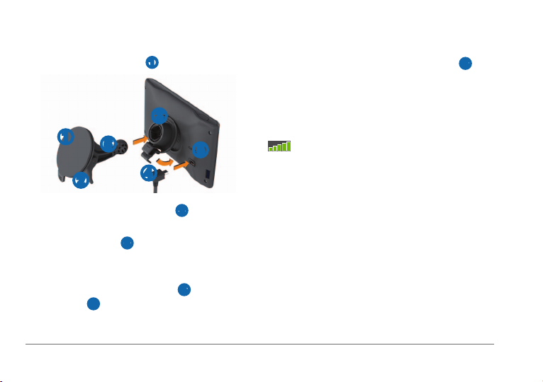
Charge your device as you drive before using it
on battery power.
Press the suction cup ➊ to the windshield.
1
➌
➊
While pressing, ip the lever ➋ back toward
2
the windshield.
Press the mount ➌ up and into the opening
3
on the back of the device until it snaps into
place.
Plug the vehicle power cable ➍ into the
4
USB port
2 Getting Started
➏
➋
➎ on the device.
➎
➍
Plug the other end of the vehicle power
5
cable into a power outlet in your vehicle.
Snap the mount onto the suction cup ➏
6
arm.
Acquiring Satellites
The device may require an open view of the
sky to acquire satellite signals. When the bars
are green, the device has acquired satellite
signals.
About myDashboard
Use myDashboard to register your device, check
for software and map updates, access product
manuals and support, and more.
Page 7
Follow the on-screen instructions.
About Garmin Express
Use Garmin Express to register your device,
check for software and map updates, access
product manuals and support, and more.
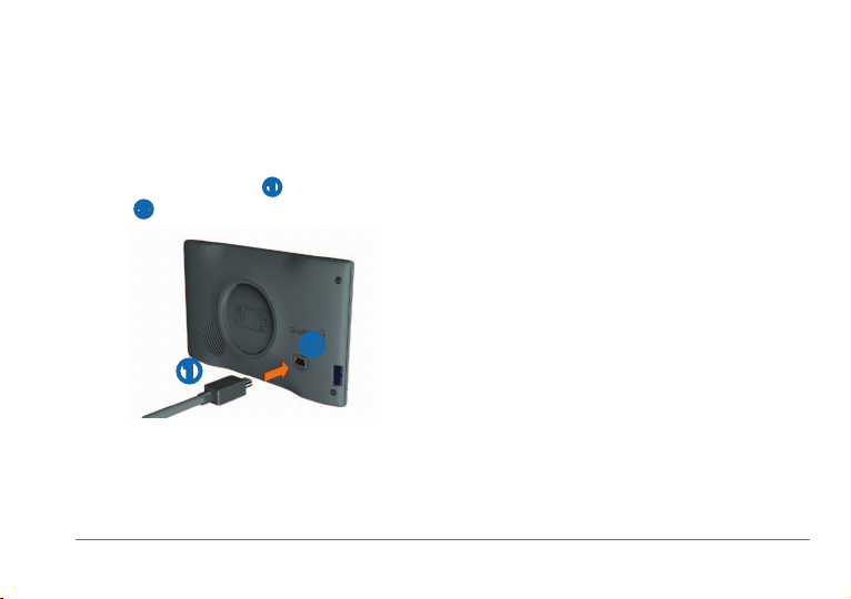
Setting Up Garmin Express
Connect a USB cable ➊ to the mini-USB
1
port
➋ on the device.
4
nüMaps Guarantee
If you register the device at www.garmin.com
/express within 90 days of acquiring satellites
while driving, your device could be eligible for
one free map update. Go to www.garmin.com
/numaps for terms and conditions.
™
Updating Maps
Register the device (page 3).
1
Under Map Updates, click Update Now.
2
Follow the on-screen instructions.
3
➋
➊
Connect the other end of the USB cable to
2
the USB port on your computer.
Go to www.garmin.com/express.
3
Getting Started 3
Activating Lifetime Maps
Go to www.garmin.com/lifetimeupdater.
1
Follow the on-screen instructions.
2
NOTE: If you register the device, you can
receive e-mail notications when a map
update is available.
Page 8
Turning Off the Device
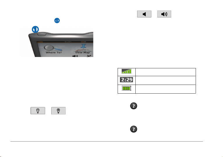
Tap the Power key ➊.
1
➊
Select Power Off.
2
• Select
• Select the Mute check box.
Status Bar Icons
The status bar is located at the top of the main
menu. The status bar icons display information
about features on the device. You can select
some icons to change settings or view additional
information.
Resetting the Device
You can reset your device if it stops functioning.
Hold the Power key for 10 seconds.
Changing the Screen Brightness
Select Settings > Display > Brightness.
1
Select or .
2
Adjusting the Volume
Select Volume.
1
Select an option:
2
4 Getting Started
Using Help
Select to view information about using
the device.
Select
or .
GPS signal status.
Current time.
Battery status.
> Search.
Page 9
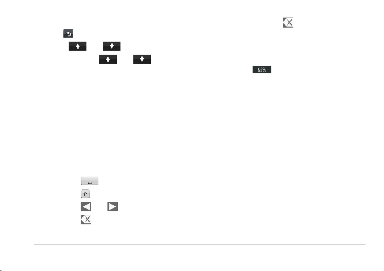
Using the On-Screen Buttons
• Hold to quickly return to the main menu.
• Select
• Select and hold
faster.
and to see more choices.
and to scroll
Using the On-Screen Keyboard
See “System Settings” to change the keyboard
layout (page 17).
Select Where To? > Points of Interest >
1
Spell Name.
Select an option.
2
• Select a character on the keyboard to
enter a letter or number.
• Select
• Select
• Select
• Select
Finding Locations 5
to add a space.
to change the character case.
and to move the cursor.
to delete a character.
• Select and hold
entry.
• Select Mode to select the keyboard
language mode.
• Select
such as punctuation marks.
Finding Locations
There are many ways to nd locations.
• By category (page 6)
• Near another location (page 6)
• By spelling the name (page 7)
• By address (page 8)
• Using recently found locations (page 8)
• Using coordinates (page 9)
• Using the map (page 9)
• Using Favorites (page 10)
to erase the entire
to enter special characters,
Page 10

Enter all or part of the name.
About Points of Interest
The detailed maps loaded in your device contain
points of interest, such as restaurants, hotels,
and auto services.
Finding a Point of Interest by Category
Select Where To? > Points of Interest.
1
Select a category.
2
If necessary, select a subcategory.
3
Select a location.
4
Select Go!.
5
To narrow your search results, you can search
within some categories.
Select Where To? > Points of Interest.
1
Select a category.
2
If necessary, select a subcategory.
3
Select Spell.
4
6 Finding Locations
5
Select Done.
6
Searching Near Another Location
By default, your device nds locations closest
to your current location. You can nd a location
near another city or location.
Select Where To? > Near.
1
Select an option, and select OK.
2
If necessary, select a location.
3
Adding a Stop to a Route
While navigating an automobile route, select
1
Where To?.
Search for the location (page 6).
2
Select Go!.
3
Select Add as a Via Point.
4
Page 11

Select the information balloon.
Saving a Home Location
You can set your home location for the location
you return to most often.
Select Where To? > Go Home.
1
Select Enter My Address, Use My Current
2
Location, or Choose from Recently
Found.
The location is saved as “Home” in Favorites
(page 10).
Going Home
Select Where To? > Go Home.
Deleting Your Home Location
Select Where To? > Favorites > Home.
1
Select the information balloon.
2
Select Delete, and select Yes�
3
Editing Your Home Location Information
Select Where To? > Favorites > Home.
1
Finding Locations 7
2
Select Edit.
3
Enter your changes.
4
Select Done.
5
Location Searches
You can search for locations by using the onscreen keyboard, entering the location’s address
or coordinates, browsing the map, and more.
Finding a Location by Spelling the Name
Select Where To? > Points of Interest >
1
Spell Name.
Enter a business name or a type of
2
business.
For example, you can enter “Starbucks” or
“Coffee.”
Select Done.
3
Select a location.
4
Page 12

Finding an Address
NOTE: The order of the steps may change
depending on the map data loaded on your
device.
Select Where To? > Address.
1
If necessary, change the state, the country,
2
or the province.
Select an option:
3
• Select Spell City, enter the city, and
select Done.
• Select Search All to search all cities in
the state or province.
Enter the address number, and select Done.
4
Enter the street name, and select Done.
5
If necessary, select the street.
6
If necessary, select the address.
7
8 Finding Locations
Finding a Location by Browsing the Map
Select Where To? > Browse Map.
1
Drag the map to nd the location.
2
Select the location.
3
An information balloon appears for the
location.
Select the information balloon.
4
Viewing a List of Recently Found
Locations
Your device stores the last 50 locations you
have found.
Select Where To? > Recently Found.
Select Where To? > Recently Found >
Clear.
Page 13

Finding a Location Using Coordinates
You can nd a location using latitude and
longitude coordinates. This method can be
helpful when geocaching.
Select Where To? > Coordinates.
1
If necessary, select Format, select the
2
correct coordinate format for the type of map
you are using, and select OK.
Select the latitude coordinate.
3
Enter the new coordinate, and select Done.
4
Select the longitude coordinate.
5
Enter the new coordinate, and select Done.
6
Select Next.
7
Select Go!.
8
Finding Locations 9
Using the Location Map
The location map appears after you select a
location from the Where To? menu.
➌
➊
➍
➋
➐
➎ ➏
• Select ➊ to save the location to your
Favorites.
• Select the information balloon
more information for the location.
• Select
• Select
• Select
• Select
➌ to zoom in and out.
➍ to create a turn-by-turn route to
this location.
➎ to return to the previous page.
➏ to set a simulated location
(page 10).
➋ to view
Page 14

• Select ➐ to view different parts of the map.
Setting a Simulated Location
If you are indoors or not receiving satellite
signals, you can use the GPS simulator to set a
simulated location.
Select Settings > System.
1
Select GPS Simulator > On > OK.
2
From the main menu, select Where To? >
3
Browse Map.
Select an area on the map.
4
An information balloon appears for the
location.
Select Set Location.
5
Saving Your Location to Favorites
From the map, select the vehicle icon.
1
Select Save Location.
2
Enter a name, and select Done.
3
Select OK.
4
The location is saved in Favorites.
Saving Locations to Favorites
Search for the location (page 6).
1
From the location map, select Save > OK.
2
Finding Favorites
Select Where To? > Favorites.
1
If necessary, select a category.
2
Select a saved location.
3
Favorites
You can save locations in your Favorites so you
can quickly nd them and create routes to them.
Your home location is also stored in Favorites.
10 Finding Locations
Editing Favorites
Select Where To? > Favorites.
1
If necessary, select a category.
2
Page 15

Select a Favorite.
3
Select the information balloon.
4
Select Edit.
5
Select an option:
6
• Select Change Name.
• To change the symbol used to mark the
Favorite on a map, select Change Map
Symbol.
• Select Change Phone Number.
• To assign categories to the Favorite,
select Change Categories.
Edit the information.
7
Select Done.
8
Select Where To? > Favorites.
1
Select the Favorite.
2
Select the information balloon.
3
Select Edit > Change Categories.
4
Select New.
5
Deleting Favorites
NOTE: Deleted Favorites cannot be recovered.
Select Where To? > Favorites.
1
If necessary, select a category.
2
Select the Favorite.
3
Select the information balloon.
4
Select Delete > Yes.
5
Adding a Category
You can add custom categories to organize your
Favorites.
NOTE: Categories appear in the Favorites menu
after you have saved more than 12 Favorites.
Finding Locations 11
Page 16

Map Pages
An icon displaying the current speed limit may
appear as you travel on major roadways.
Following an Automobile Route
The speed limit icon feature is for information
only and does not replace the driver’s
responsibility to abide by all posted speed limit
signs and to use safe driving judgment at all
times. Garmin will not be responsible for any
trafc nes or citations that you may receive for
failing to follow all applicable trafc laws and
signs.
The route is marked with a magenta line. A
checkered ag marks your destination.
As you travel, the device guides you to the
destination with voice prompts, arrows on the
map, and directions at the top of the map. If
you depart from the original route, the device
recalculates the route and provides new
directions.
12 Map Pages
Taking a Detour
While navigating a route, you can use detours
to avoid obstacles ahead of you, such as
construction zones.
NOTE: If the route you are currently taking is
the only reasonable option, the device might not
calculate a detour.
While navigating a route, select to return
1
to the main menu.
Select Detour.
2
Page 17

Stopping the Route
While navigating a route, select > Stop.
Navigating Off Road
You can create straight-line routes that do not
follow roadways.
Select Settings > Navigation.
1
Select Route Preference > Off Road > OK.
2
The route will be calculated as a straight line
to the location.
Viewing Current Location Information
Use the Where Am I? page to view information
about your current location. This is helpful if you
need to tell emergency personnel your location.
From the map, select the vehicle icon.
Finding Nearby Services
From the map, select the vehicle icon.
1
Select Hospitals, Police Stations, or Fuel
2
to view the nearest locations in that category.
Changing the Map Data Field
From the map, select a data eld.
1
Select a type of data to display.
2
Select OK.
3
Map Pages 13
Map Pages
Viewing Trip Information
The trip information page displays your present
speed and provides statistics about your trip.
TIP: If you make frequent stops, leave the
device turned on so it can accurately measure
elapsed time during the trip.
From the map, select the Speed eld.
Page 18

From the map, select the Speed eld >
1
Reset.
Select an option:
2
• Select Reset Trip Data to reset the
information on the trip computer.
• Select Reset Max� Speed to reset the
maximum speed.
Select OK.
3
Viewing a List of Turns
When you are navigating a route, you can view
all of the turns and maneuvers for your entire
route and the distance between turns.
Select the text bar on the top of the map.
1
14 Map Pages
Select a turn.
2
The details for the turn appear. If available,
an image of the junction appears for
junctions on major roadways.
Viewing the Entire Route on the Map
While navigating an automobile route, select
1
the navigation bar at the top of the map.
Select Show Map.
2
Page 19

Viewing the Next Turn
While navigating an automobile route, a preview
of the next turn, lane change, or other maneuver
appears in the upper-left corner of the map.
The preview includes the distance to the turn or
maneuver and the lane in which you should be
traveling, if available.
From the map, select
.
Select Junction View.
2
Data Management
You can store les, such as JPEG image les,
on your device. The device has a memory card
slot for additional data storage.
NOTE: The device is not compatible with
Viewing an Upcoming Junction
While navigating an automobile route, you can
view the junctions on major roadways. When
you approach a junction in a route, the image of
that junction appears briey, if available.
From the map, select .
1
Data Management 15
Windows
OS 10.3 and earlier.
®
95, 98, Me, Windows NT®, and Mac®
Page 20

File Types
The device supports the following le types:
• Maps and GPX waypoint les from
MapSource
• GPI custom POI les from Garmin POI
Loader.
®
About Memory Cards
You can purchase memory cards from an
electronics supplier, or purchase pre-loaded
Garmin mapping software (www.garmin.com
/trip_planning). In addition to map and data
storage, the memory card can be used to store
les such as maps, images, geocaches, routes,
waypoints, and custom POIs.
Installing a Memory Card
The device supports microSD™ and microSDHC
memory or data cards.
16 Data Management
Insert a memory card into the slot on the
device.
Transferring Files from Your Computer
Connect the device to your computer (page
1
3).
Your device and memory card appear
as removable drives in My Computer in
Windows and as mounted volumes on Mac
computers.
NOTE: Some computers with multiple
network drives cannot display nüvi drives.
See your operating system Help le to learn
how to map the drives.
On your computer, open the le browser.
2
Select the le.
3
Select Edit > Copy.
4
Page 21

Open the Garmin or memory card drive or
5
volume.
Select Edit > Paste.
6
The le appears in the list of les in the
device memory or on the memory card.
Open the Garmin drive or volume.
1
If necessary, open a folder or volume.
2
Select the le.
3
Press the Delete key on your keyboard.
4
Disconnecting the USB Cable
Complete an action:
1
• For Windows computers, click the eject
icon
in your system tray.
• For Mac computers, drag the volume
icon to the Trash
Disconnect the cable from your computer.
2
.
Deleting Files
If you do not know the purpose of a le, do not
delete it. Your device memory contains important
system les that should not be deleted.
Customzing the Device 17
Customizing the Device
Select Settings.
1
Select a setting category.
2
Select the setting to change it.
3
System Settings
Select Settings > System.
• GPS Simulator—stops the device from
receiving a GPS signal, and saves battery
power.
• Units—sets the unit of measure used for
distances.
Page 22

• Keyboard Layout—sets the keyboard
layout.
• Safe Mode— disables all functions that
require signicant operator attention and
could become a distraction while driving.
• About—displays the nüvi software version
number, the unit ID number, and information
about several other software features. You
need this information when you update the
system software or purchase additional map
data.
Navigation Settings
Select Settings > Navigation.
• Route Preference—select a preference for
calculating your route.
• Avoidances—select the road types you
want to avoid on your routes.
18 Customzing the Device
Display Settings
Select Settings > Display.
• Color Mode—sets a light background (Day),
a dark background (Night), or automatically
switches between the two based on the
sunrise time and the sunset time for your
current location (Auto).
• Screenshot—allows you to take a picture of
the device screen. Screenshots are saved in
the Screenshot folder of the device storage.
• Brightness—changes the brightness of the
screen. Decreasing the brightness can save
battery power.
Time Settings
Select Settings > Time.
• Time Format—select a 12-hour, 24-hour, or
UTC time format.
Page 23

• Current Time—manually set the time on
your nüvi. Select Automatic to have the
device set the time based on your location.
Language Settings
Select Settings > Language.
• Voice Language—sets the language for
voice prompts.
• Text Language—sets all on-screen text to
the selected language.
NOTE: Changing the text language does not
change the language of user-entered data or
map data, such as street names.
• Keyboard—sets the language for your
keyboard.
Map Settings
Select Settings > Map.
Customzing the Device 19
• Map Detail—adjusts the amount of detail
shown on the map. Showing more detail can
cause the map to redraw slower.
• Map View—sets a map perspective.
◦ Track Up—displays the map in two
dimensions (2D) with your direction of
travel at the top.
◦ North Up—displays the map in 2D with
North at the top.
◦ 3D—displays the map in three
dimensions (3D) in Track Up.
• Vehicle—select Change to change the icon
used to display your position on the map.
Download additional vehicle icons at www
.garmingarage.com.
• Trip Log—shows or hides the log of your
travels.
• Map Data Layout—changes the amount of
data visible on the map.
Page 24

• Info—view the maps and the version of each
map loaded on your nüvi. Select a map to
enable or disable that map.
TIP: To purchase additional map products,
go to www.garmin.com/us/maps.
Proximity Points Settings
Select Settings > Proximity Points�
• Alerts—noties you when you approach
custom safety cameras (page 23). See
www.garmin.com/safetycamera for more
information.
Restoring Settings
You can restore a category of settings or all
settings to the factory defaults.
Select Settings.
1
If necessary, select a settings category.
2
Select Restore.
3
20 Appendix
Caring for Your Device
Avoid dropping your device and operating it in
high-shock and high-vibration environments.
Do not expose the device to water.
Contact with water can cause this device to
malfunction.
Do not store the device where prolonged
exposure to extreme temperatures can occur,
because it can cause permanent damage.
Never use a hard or sharp object to operate the
touchscreen, or damage may result.
Appendix
Page 25

Cleaning the Outer Casing
Avoid chemical cleaners and solvents that can
damage plastic components.
Clean the outer casing of the device (not the
1
touchscreen) using a cloth dampened with a
mild detergent solution.
Wipe the device dry.
2
Cleaning the Touchscreen
Use a soft, clean, lint-free cloth.
1
If necessary, use water, isopropyl alcohol, or
2
eyeglass lens cleaner.
Apply the liquid to the cloth.
3
Gently wipe the screen with the cloth.
4
Avoiding Theft
• Remove the device and mount from sight
when not in use.
Appendix 21
• Remove the residue left on the windshield by
the suction cup.
• Do not keep your unit in the glove
compartment.
• Register your device at http://my.garmin
.com.
Erasing User Data
Turn the device on.
1
Hold your nger on the lower-right corner of
2
the device screen.
Keep your nger pressed until the pop-up
3
window appears.
Select Yes to clear all user data.
4
All original settings are restored. Any items that
you have saved are erased.
Extending the Battery Life
• Keep your device away from extreme
temperatures.
Page 26

• Decrease the screen brightness (page 4).
• Do not leave your device in direct sunlight.
• Decrease the volume (page 4).
Install a 1 A fast-blow fuse.
3
Place the metal tip in the end piece.
4
Screw the end piece back into the vehicle
5
power cable.
Changing the Fuse in the Vehicle Power Cable
When replacing the fuse, do not lose any of the
small pieces and make sure they are put back
in the proper position. The vehicle power cable
does not work unless it is assembled correctly.
If your device does not charge in your vehicle,
you may need to replace the fuse located at the
tip of the vehicle adapter.
Unscrew the end piece.
1
TIP: You may need to use a coin to remove
the end piece.
Remove the end piece, the metal tip, and the
2
fuse (glass and metal cylinder).
22 Appendix
Removing Suction Cup Mount from the Windshield
Removing the Suction Cup Mount from
the Windshield
Flip the lever on the suction cup mount
1
toward you.
Pull the tab on the suction cup toward you.
2
About nüMaps Lifetime
For a one-time payment, you can receive up
to four map updates each year for the life of
your device. For more information on nüMaps
Lifetime
and complete terms and conditions,
Page 27

go to www.garmin.com, and click Maps &
Accessories.
Purchasing Accessories
Go to http://buy.garmin.com.
Safety Cameras
‹ CAUTION
Garmin is not responsible for the accuracy of,
or the consequences of using, a custom POI or
safety camera database.
Safety camera information is available in some
locations. Check www.garmin.com/safetycamera
for availability. For these locations, the nüvi
includes the locations of hundreds of safety
cameras. Your nüvi alerts you when you are
approaching a safety camera and can warn you
if you are driving too fast. The data is updated at
least weekly, so you always have access to the
most up-to-date information.
You can purchase a new region or extend an
existing subscription at any time. Each region
that you purchase has an expiration date.
Appendix 23
Contacting Garmin Product Support
You can contact Garmin Product Support if you
have any questions about this product.
• Go to www.garmin.com/support.
• In the USA, call (913) 397.8200 or
1-800-800-1020.
• In the UK, call 0808 2380000.
• In Europe, call +44 (0) 870.8501241.
Page 28

Troubleshooting
Problem Solution
My device is not acquiring
satellite signals
The suction cup will not
stay on my windshield.
The device does not
charge in my vehicle.
My battery does not stay
charged for very long.
My battery gauge does not
seem accurate.
How do I know my device
is in USB mass storage
mode?
24 Appendix
• Select Settings > System > GPS Simulator > Off.
• Make sure your device is out of parking garages and away from tall buildings
and trees.
• Remain stationary for several minutes.
• Clean the suction cup and windshield with rubbing alcohol.
• Dry with a clean, dry cloth.
• Mount the suction cup (page 1).
• Check the fuse in the vehicle power cable (page 22).
• Verify the vehicle is turned on and is supplying power to the power outlet.
• Your device can only charge between 32° and 113°F (between 0° and 45°C). If
the device is placed in direct sunlight or in a hot environment, it cannot charge.
To maximize the time between charges, turn down the backlight (page 18).
Allow the unit to fully discharge, and fully charge it (without interrupting the charge
cycle).
When your device is in USB mass storage mode, a picture of a device connected
to a computer is shown on the device screen. Also, you should see one or two new
removable disk drives listed in My Computer.
Page 29

The device is connected
to the computer, but it will
not go into mass storage
mode.
I cannot see any new
removable drives in my list
of drives.
Appendix 25
Disconnect the USB cable from your computer.
1
Turn off the device.
2
Plug the USB cable into a USB port on your computer and into your device.
3
The device automatically turns on and goes into USB mass storage mode.
Verify your device is connected to a USB port and not a USB hub.
4
If you have several network drives mapped on your computer, Windows can have
trouble assigning drive letters to your device drives. Refer to your operating system
Help le to learn how to map or assign drive letters.
Page 30

Page 31

Page 32

www�garmin�com/support
913-397-8200
1-800-800-1020
00 32 2 672 52 54
0180 5 / 42 76 46 - 880
00800 4412 454
+44 2380 662 915
Garmin International, Inc
1200 East 151st Street,
Olathe, Kansas 66062, USA
Garmin (Europe) Ltd�
Liberty House, Hounsdown Business Park
Southampton, Hampshire, SO40 9LR UK
Garmin Corporation
No. 68, Zhangshu 2nd Road, Xizhi Dist.
New Taipei City, 221, Taiwan (R.O.C.)
© 2012 Garmin Ltd. or its subsidiaries
0808 238 0000
+44 870 850 1242
00 45 4810 5050
00 39 02 3669 9699
00 35 1214 447 460
®
, the Garmin logo, and MapSource® are trademarks of Garmin
Garmin
Ltd. or its subsidiaries, registered in the USA and other countries. nüMaps
™
Guarantee
its subsidiaries. These trademarks may not be used without the express
1-866-429-9296
00 358 9 6937 9758
0800-0233937
00 34 902 007 097
, and nüMaps Lifetime™ are trademarks of Garmin Ltd. or
43 (0) 3133 3181 0
00 331 55 69 33 99
815 69 555
00 46 7744 52020
permission of Garmin.
®
Windows
is a registered trademarks of Microsoft Corporation in the United
States and/or other countries. Mac
Computer, Inc. microSD
®
is a registered trademark of Apple
™
is a trademark of SD-3C, LLC.
TA-2012/1346
TA-2012/1347
 Loading...