

Garmin 0163700 Users Manual
Foreword
Getting
Started
Audio &
Xpdr Ctrl
Com/Nav
FPL
Direct-To
Proc
Charts
Wpt Info
Map
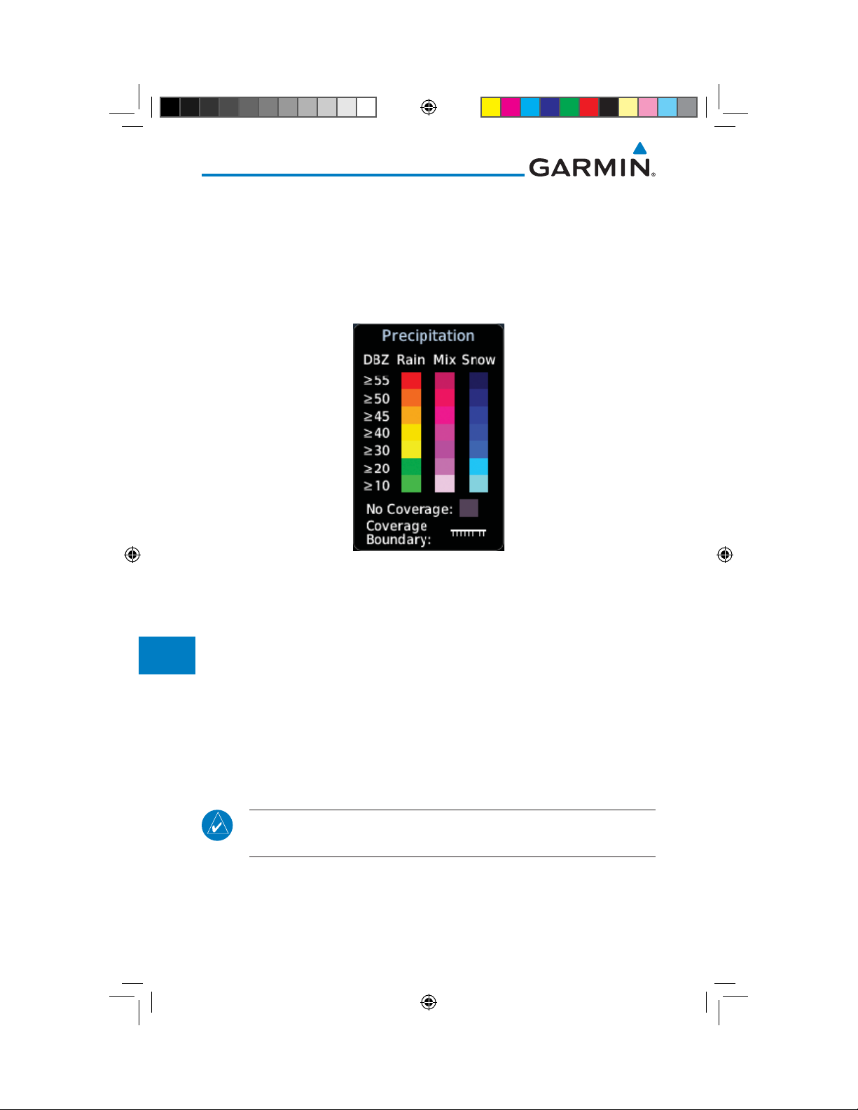
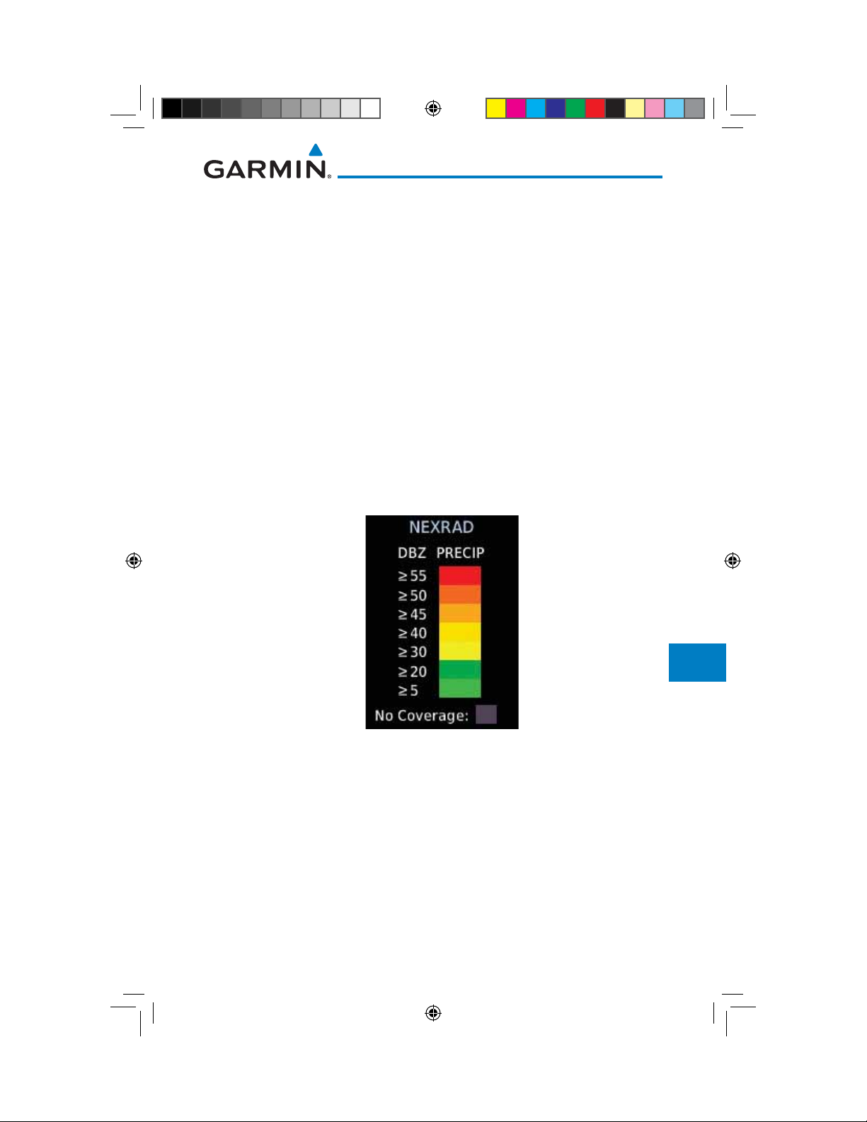
12.5.7 Precipitation (PRECIP) Data
Graphical data is overlaid on the map indicating the rainfall detected by
ground based radar for a specific area. The colors indicating increasing levels
of rainfall progresses from light green for light rainfall to red for heavy rainfall.
Review the Limitations section in the front of this guide for the limitations that
apply to the Connext data. Rainfall data is color coded as follows:
Traffic
Terrain
Weather
Nearest
Services/
Music
Utilities
System
Messages
Symbols
Appendix
Index
Figure 12-82 Connext PRECIP Weather Map Display and Legend
The "No Coverage" color indicates that no data is available for that area, and
rainfall in that area is unknown.
When weather data is received, the airborne system will display that data for
20 minutes. If no new data has been received for a given area, the rainfall will
be removed after 20 minutes and the area will revert back to the "No Coverage"
color.
The Connext Weather Function is based on a ground-to-air data link and
requires that the appropriate ground systems are broadcasting weather data and
the aircraft is within reception range of the Ground Broadcast Transceiver (GBT).
12.5.7.1 Animating Precipitation Data
NOTE: Animated Precipitation functionality is available in software version
6.00 and later.
When Precipitation Data is enabled for display and more than two
Precipitation images have been received by the GTN, the Precipitation display
can be animated on the Connext Weather page. As new Precipitation images are
12-64
Garmin GTN 725/750 Pilot’s Guide
190-01007-03 Rev. J
190-01007-03-Final.indb 64 7/9/2015 2:08:16 PM
received, the GTN will automatically store them for future animation. The GTN
can animate up to six Precipitation images from oldest to newest, showing each
for one second and the newest for two seconds.
Foreword
Getting
Started
1. While viewing the Connext Weather page with Precipitation
enabled for display, press the Play PRCP key to start the
Audio &
Xpdr Ctrl
Precipitation animation.
2. Touch the Stop PRCP key to stop the Precipitation animation.
Com/Nav
The animation will also stop when leaving the page or turning
off Precipitation on the Connext weather page.
FPL
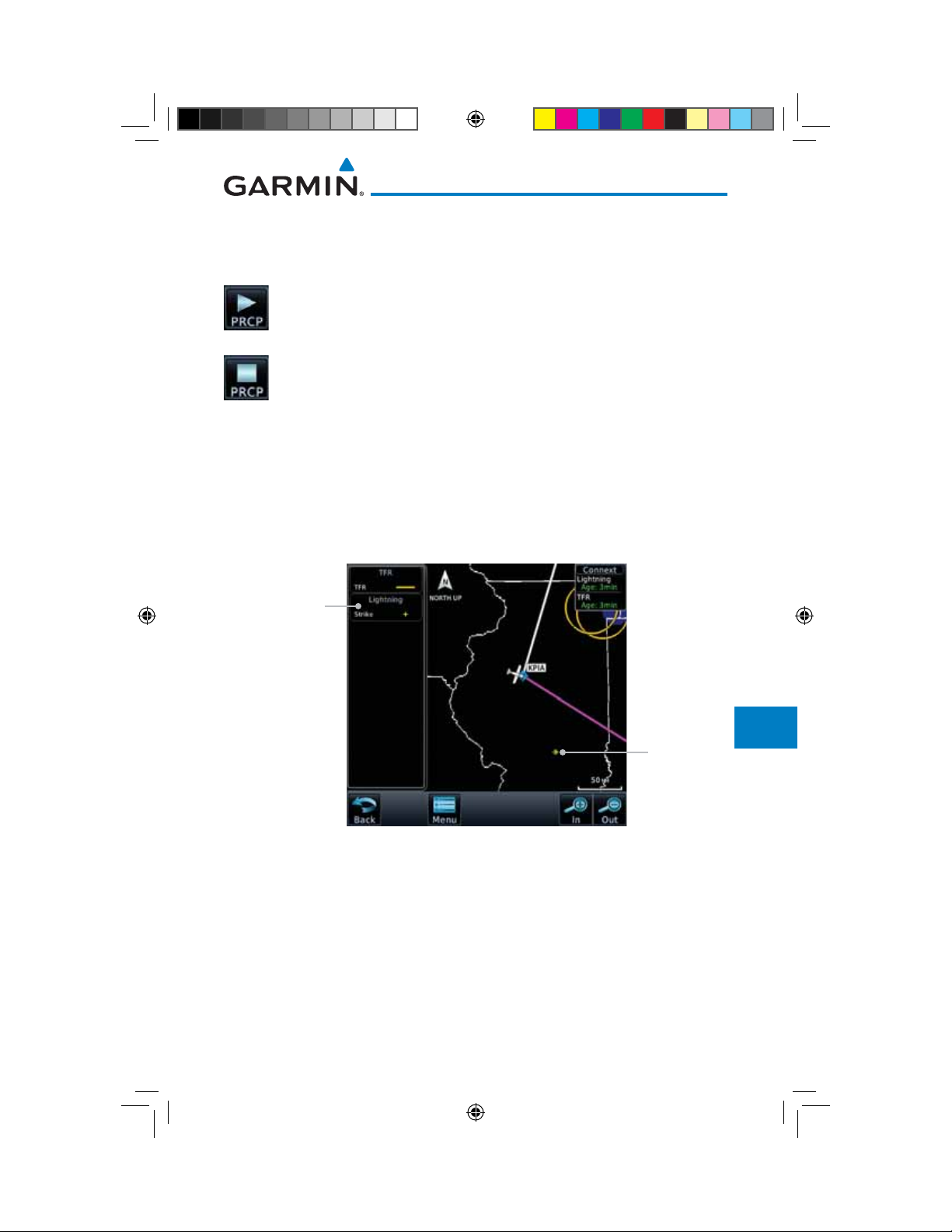
12.5.8 Lightning
Direct-To
Lightning data shows the approximate location of cloud-to-ground lightning
strikes. A strike icon represents a strike that has occurred within a two kilometer
Proc
(1.08 NM) region. The exact location of the lightning strike is not displayed.
Only cloud to ground strikes are reported in the US and extreme southern
Canada (cloud to cloud strikes are not reported).
Lightning
Legend
Lightning
Symbol
Figure 12-83 Connext Data Link Lightning and Legend
Charts
Wpt Info
Map
Traffic
Terrain
Weather
Nearest
Services/
Music
Utilities
System
Messages
Symbols
Appendix
Garmin GTN 725/750 Pilot’s Guide
190-01007-03-Final.indb 65 7/9/2015 2:08:17 PM
12-65190-01007-03 Rev. J
Index
Foreword
Getting
Started
Audio &
Xpdr Ctrl
Com/Nav
FPL
Direct-To
Proc
Charts
Wpt Info
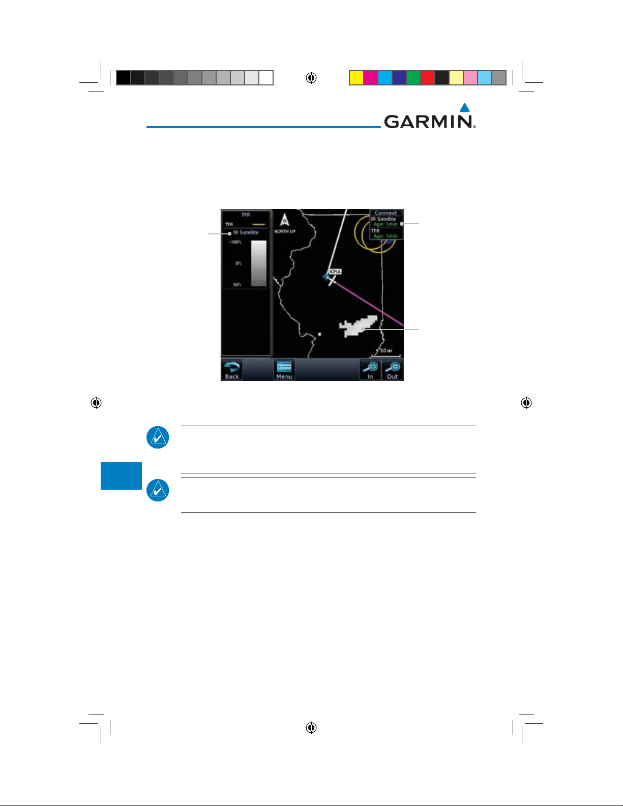
12.5.9 Infrared Satellite Data
Infrared Satellite data is available over North America and Europe and depicts
cloud top temperatures from satellite imagery. Brighter cloud top colors indicate
cooler temperatures occurring at higher altitudes. Information is updated every
half hour.
IR Satellite
Legend
IR Satellite
Product Age
IR Satellite
Coverage
Map
Traffic
Terrain
Weather
Nearest
Services/
Music
Utilities
System
Messages
Symbols
Appendix
Figure 12-84 Connext Infrared Satellite Data Map Display and Legend
12.5.10 METARs
NOTE: Atmospheric pressure reported for METARs is given in hectopascals
(hPa), except in the United States, where it is reported in inches of mercury
(in Hg). Temperatures are reported in Celsius.
NOTE: METAR information is only displayed within the installed aviation
database service area.
METAR (METeorological Aerodrome Report), known as an Aviation Routine
Weather Report, is the standard format for current weather observations.
METARs are generally updated hourly, but some site are more frequent. Special
updates are done as conditions warrant. METARs typically contain information
about the temperature, dew point, wind, precipitation, cloud cover, cloud
heights, visibility, and barometric pressure. They can also contain information
on precipitation amounts, lightning, and other critical data. METARs are shown
as colored flags at airports that provide them.
12-66
Index
190-01007-03-Final.indb 66 7/9/2015 2:08:17 PM
Garmin GTN 725/750 Pilot’s Guide
190-01007-03 Rev. J
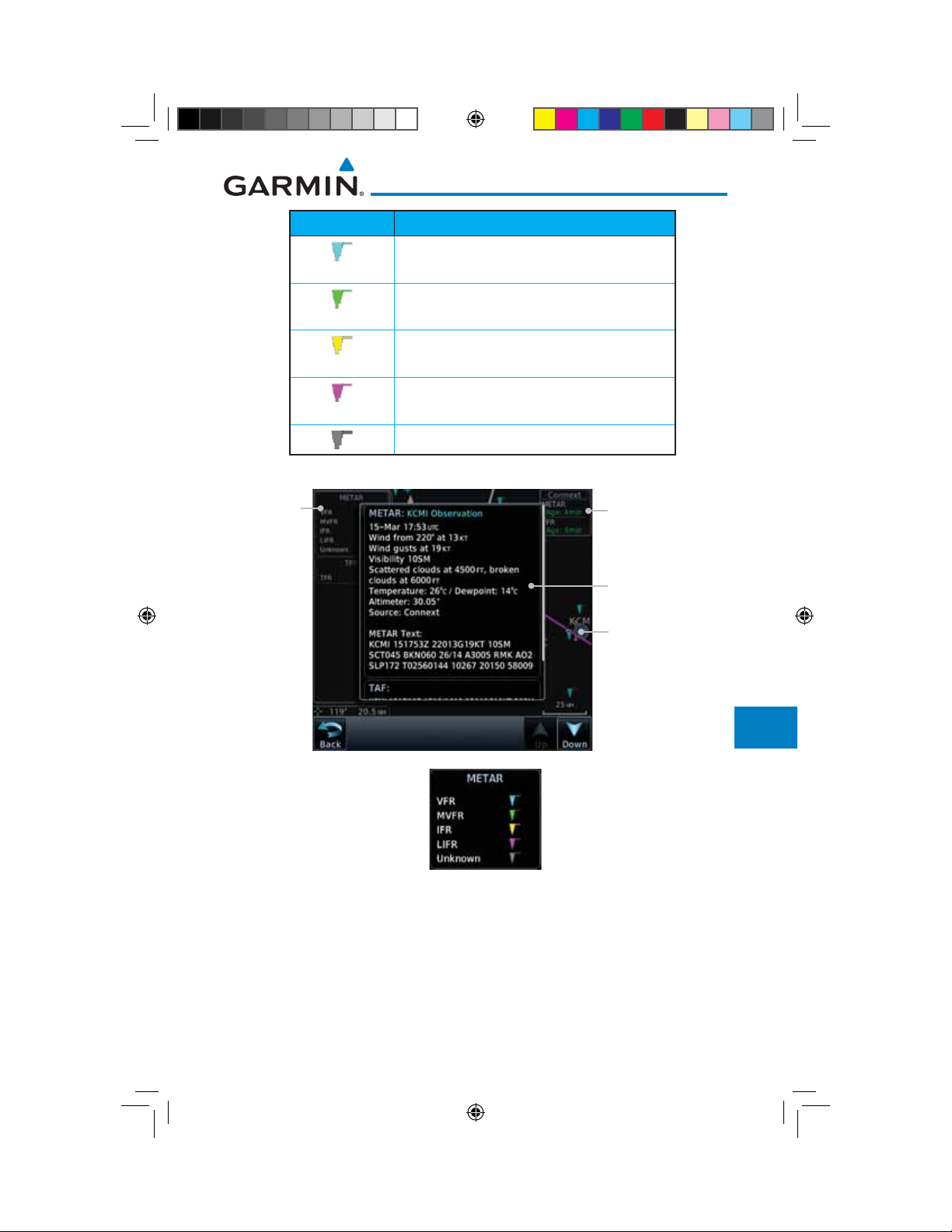
METAR Symbol Description
VFR (ceiling greater than 3000 ft. AGL and
visibility greater than five miles)
Marginal VFR (ceiling 1000–3000 ft. AGL
and/or visibility three to five miles)
IFR (ceiling 500 to below 1000 ft. AGL and/or
visibility one mile to less than three miles)
Low IFR (ceiling below 500 ft. AGL or visibility
less than one mile)
Unknown
Foreword
Getting
Started
Audio &
Xpdr Ctrl
Com/Nav
FPL
Direct-To
Metar
Legend
Table 12-7 METAR Symbols
Product Age
METAR Detail
Selected METAR (VFR)
Figure 12-85 Connext Weather - Graphic METARs and Legend
Proc
Charts
Wpt Info
Map
Traffic
Terrain
Weather
Nearest
Services/
Music
Utilities
System
Messages
Symbols
Appendix
Garmin GTN 725/750 Pilot’s Guide
190-01007-03-Final.indb 67 7/9/2015 2:08:17 PM
12-67190-01007-03 Rev. J
Index
Foreword
Getting
Started
Audio &
Xpdr Ctrl
Com/Nav
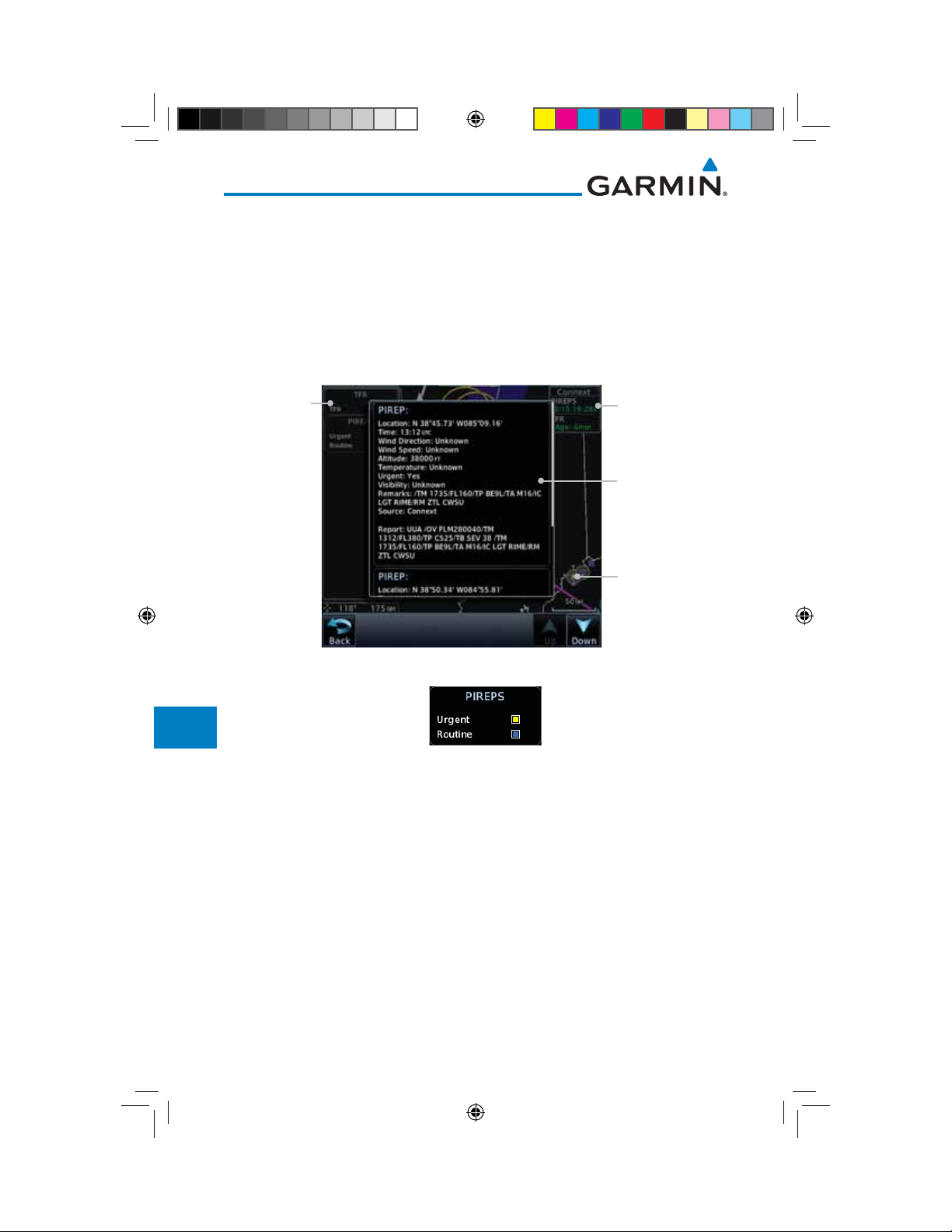
12.5.11 PIREPs
Pilot Weather Reports (PIREPs) provide timely weather information for a
particular route of flight. When significant weather conditions are reported or
forecast, Air Traffic Control (ATC) facilities are required to solicit PIREPs. A
PIREP may contain non-forecast adverse weather conditions, such as low inflight visibility, icing conditions, wind shear, and turbulence. PIREPs are issued
as either Routine (UA) or Urgent (UUA).
FPL
Direct-To
Proc
Charts
Wpt Info
Map
Traffic
Terrain
Weather
Nearest
Services/
Music
PIREP
Legend
Product Age
PIREP Detail
Selected PIREP
Figure 12-86 Connext Weather - PIREPs
Figure 12-87 Connext Weather - PIREPs Legend
Utilities
System
Messages
Symbols
Appendix
12-68
Index
190-01007-03-Final.indb 68 7/9/2015 2:08:17 PM
Garmin GTN 725/750 Pilot’s Guide
190-01007-03 Rev. J
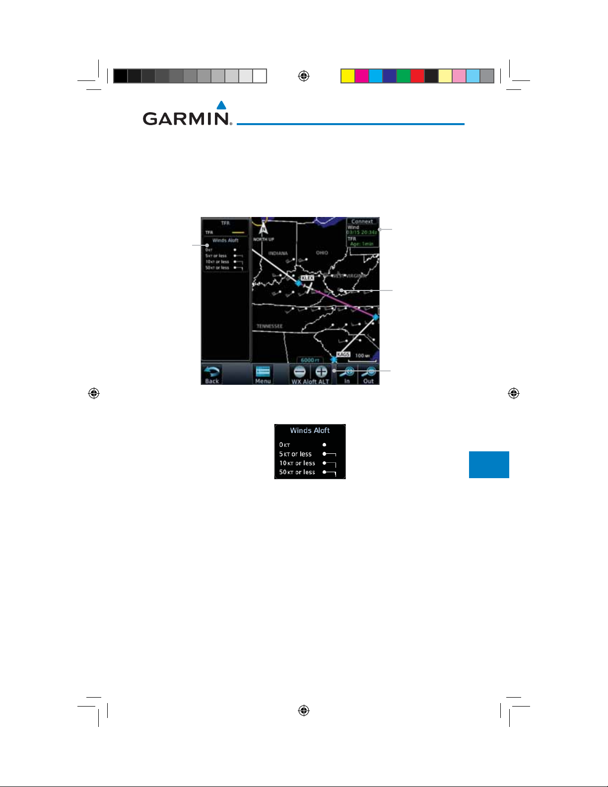
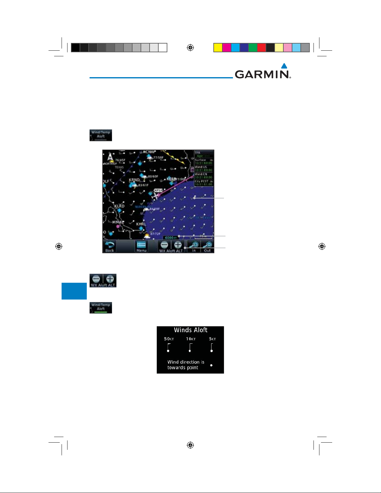
12.5.12 Winds Aloft
Winds Aloft data shows the forecast wind speed and direction at the surface
and at selected altitudes. Altitudes can be selected in 3000 foot increments from
the surface up to 42,000 feet MSL. Pressing the WX Aloft ALT + or – soft keys
steps down or up in 3,000 foot increments.
Foreword
Getting
Started
Audio &
Xpdr Ctrl
Product Age
Winds Aloft
Legend
Winds Aloft
Symbol
Winds Aloft
Altitude Selection
Figure 12-88 Connext Weather - Winds Aloft
Figure 12-89 Connext Weather - Winds Aloft Legend
Winds Aloft Altitude
The Winds Aloft Altitude option allows you to select the altitude for the
Winds Aloft weather product. Altitude can be selected in 3,000 foot increments
from the surface up to 42,000 feet MSL.
Pressing the WX Aloft ALT + or – soft keys steps down or up in 3,000 foot
increments. In the figure shown above, 6,000 feet is selected and Winds Aloft
data is shown for winds reported at an altitude of 6,000 feet.
Com/Nav
FPL
Direct-To
Proc
Charts
Wpt Info
Map
Traffic
Terrain
Weather
Nearest
Services/
Music
Utilities
System
Messages
Symbols
Appendix
Garmin GTN 725/750 Pilot’s Guide
190-01007-03-Final.indb 69 7/9/2015 2:08:17 PM
12-69190-01007-03 Rev. J
Index
Foreword
Getting
Started
Audio &
Xpdr Ctrl
Com/Nav
FPL
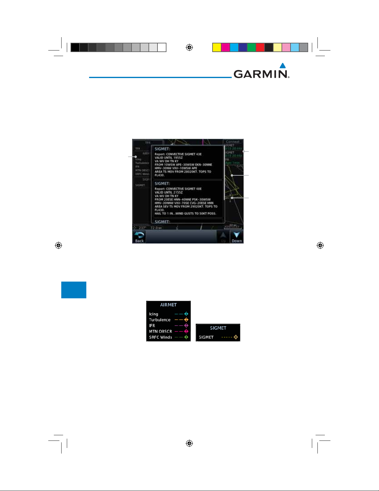
12.5.13 SIGMETs and AIRMETs
SIGMETs (SIGnificant METeorological Information) and AIRMETs (AIRmen’s
METeorological Information) are broadcast for potentially hazardous weather
considered of importance to aircraft. A Convective SIGMET is issued for
hazardous convective weather. A localized SIGMET is a significant weather
condition occurring at a localized geographical position.
SIGMET/AIRMET
Legend
Product Age
Direct-To
Proc
Charts
Wpt Info
Map
Traffic
Terrain
Weather
Nearest
Services/
Music
Utilities
System
Messages
SIGMET Line
Selected SIGMET
Line
Figure 12-90 Connext Weather Page - AIRMETs/SIGMETs
When enabled, SIGMET/AIRMETs advise the pilot of potentially hazardous
weather. SIGMETs are directed to all aircraft. AIRMETs are intended for light
aircraft. SIGMET/AIRMET data covers icing, turbulence, dust, and volcanic ash
as issued by the National Weather Service. The update rate is selected in the
Connext Settings Menu.
Figure 12-91 Connext Weather - AIRMETs/SIGMETs Detail and Legend
When enabled, the following AIRMETs are available for display:
• Icing
• Turbulence
Symbols
• IFR conditions
• Mountain obscuration
Appendix
Index
190-01007-03-Final.indb 70 7/9/2015 2:08:18 PM
• Surface winds
12-70
Garmin GTN 725/750 Pilot’s Guide
190-01007-03 Rev. J
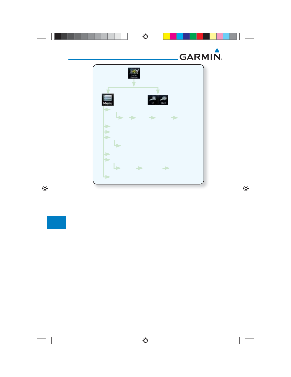
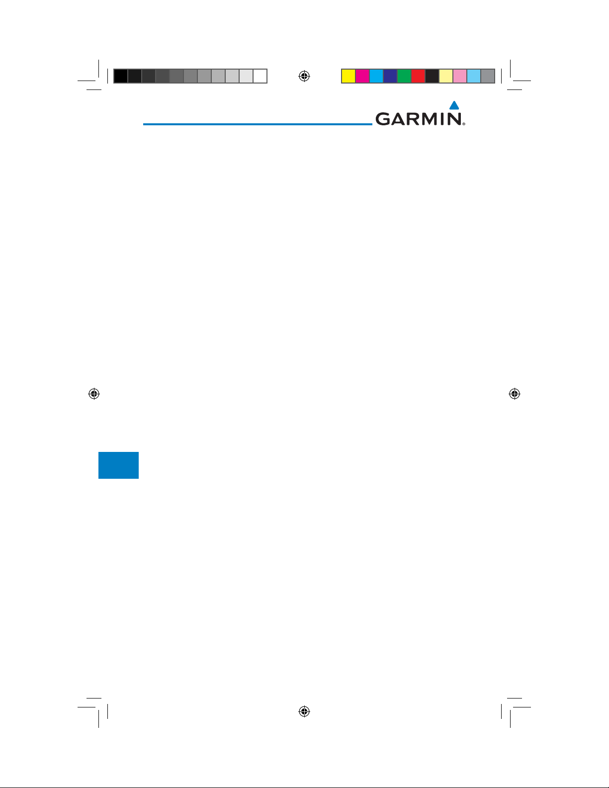
12.6 FIS-B Weather
Foreword
The Flight Information Services (FIS-B) function is capable of displaying text
Getting
Started
and graphic weather information with GDL 88 installations. No subscription for
FIS-B services is required with the GDL 88.
The FIS-B Function is a graphic weather display capable of displaying
graphical weather information on UAT equipped installations. Graphical data is
overlaid on the map indicating the rainfall detected by ground based radar for a
Audio &
Xpdr Ctrl
Com/Nav
FPL
specific area. Colors are used to identify the different NEXRAD echo intensities
(reflectivity) measured in dBZ (decibels of Z). “Reflectivity” (designated by the
Direct-To
letter Z) is the amount of transmitted power returned to the radar receiver.
The dBZ values increase as returned signal strength increases. Precipitation
Proc
intensity is displayed using colors corresponding to the dBZ values. Review the
Limitations section in the front of this guide for the limitations that apply to the
Charts
FIS-B data. An example of how rainfall data is color coded follows:
Wpt Info
Map
Traffic
Terrain
Weather
Nearest
Services/
Figure 12-92 FIS-B Weather Precipitation Legend
A cyan checkerboard pattern indicates that no data is available for that area,
Music
Utilities
and rainfall in that area is unknown.
The FIS-B Function is based on a ground-to-air data link and requires that
System
the appropriate ground systems are broadcasting weather data and the aircraft is
within reception range of the Ground Broadcast Transceiver (GBT).
Garmin GTN 725/750 Pilot’s Guide
190-01007-03-Final.indb 71 7/9/2015 2:08:18 PM
Messages
Symbols
Appendix
12-71190-01007-03 Rev. J
Index
Foreword
Getting
Started
Audio &
Xpdr Ctrl
Com/Nav
FPL
Direct-To
Proc
Charts
Wpt Info
Map
Traffic
Terrain
Weather
Nearest
Services/
Music
NEXRAD
Off CONUS Regional Combined
METAR
PIREP
Wind/Temp Aloft
1,000 ft ... 45,000 ft
SIGMET/AIRMET
Orientation
Track Up Heading Up North Up
Legend
Figure 12-93 FIS-B Weather Functional Diagram
Utilities
System
Messages
Symbols
Appendix
12-72
Index
190-01007-03-Final.indb 72 7/9/2015 2:08:18 PM
Garmin GTN 725/750 Pilot’s Guide
190-01007-03 Rev. J
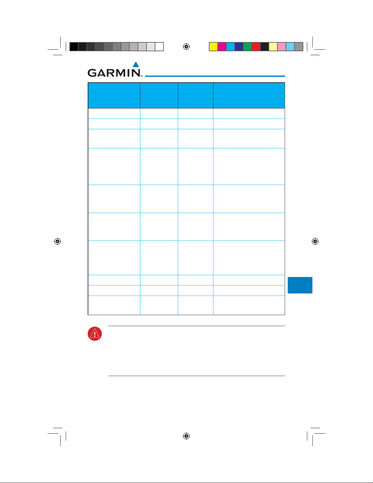
Weather Product Expiration
Time
(Minutes)
Transmission
Interval
(Minutes)
Update Interval (Minutes)
CONUS NEXRAD 60 15 15
Regional NEXRAD 30 2.5 5
AIRMETs 60 5 As Available
(Typically 20 minutes)
Foreword
Getting
Started
Audio &
Xpdr Ctrl
Com/Nav
SIGMETs 60 5 As Available
(Typically 20 minutes), then
at 15 minute intervals for
1 hour
METARs 90 5 1 minute (where available),
As Available otherwise
(Typically d 20 minutes)
Winds and
Temperatures Aloft
90 or at the
end of the
10 12 hours
valid period
Pilot Weather
Report (PIREP)
90 10 As available
|(Typically 20 minutes)
(Blue - Regular,
Yellow - Urgent)
TAFs 60 10 8 hours
TFRs 60 10 20
NOTAMs 60 10 As available
(Typically 20 minutes)
Table 12-8 FIS-B Weather Products and Aging
FPL
Direct-To
Proc
Charts
Wpt Info
Map
Traffic
Terrain
Weather
Nearest
Services/
Music
WARNING: Do not use the indicated data link weather product age to
Utilities
determine the age of the weather information shown by the data link
weather product. Due to time delays inherent in gathering and processing
weather data for data link transmission, the weather information shown by
System
the data link weather product may be significantly older than the indicated
weather product age.
Garmin GTN 725/750 Pilot’s Guide
190-01007-03-Final.indb 73 7/9/2015 2:08:18 PM
Messages
Symbols
Appendix
12-73190-01007-03 Rev. J
Index
Foreword
Getting
Started
Audio &
Xpdr Ctrl
Com/Nav
12.6.1 FIS-B Operation
Weather data reception time is shown in the upper right corner of the screen.
An indicated time shows if the aircraft is currently within reception coverage
of a ground station with weather broadcast capabilities. The ground system
determines the weather coverage area and extent of data that is transmitted by
each ground station. The GDL 88 can display weather from multiple ground
stations.
FPL
Direct-To
Proc
Charts
Wpt Info
Map
Traffic
Terrain
Weather
Nearest
Services/
Music
Utilities
System
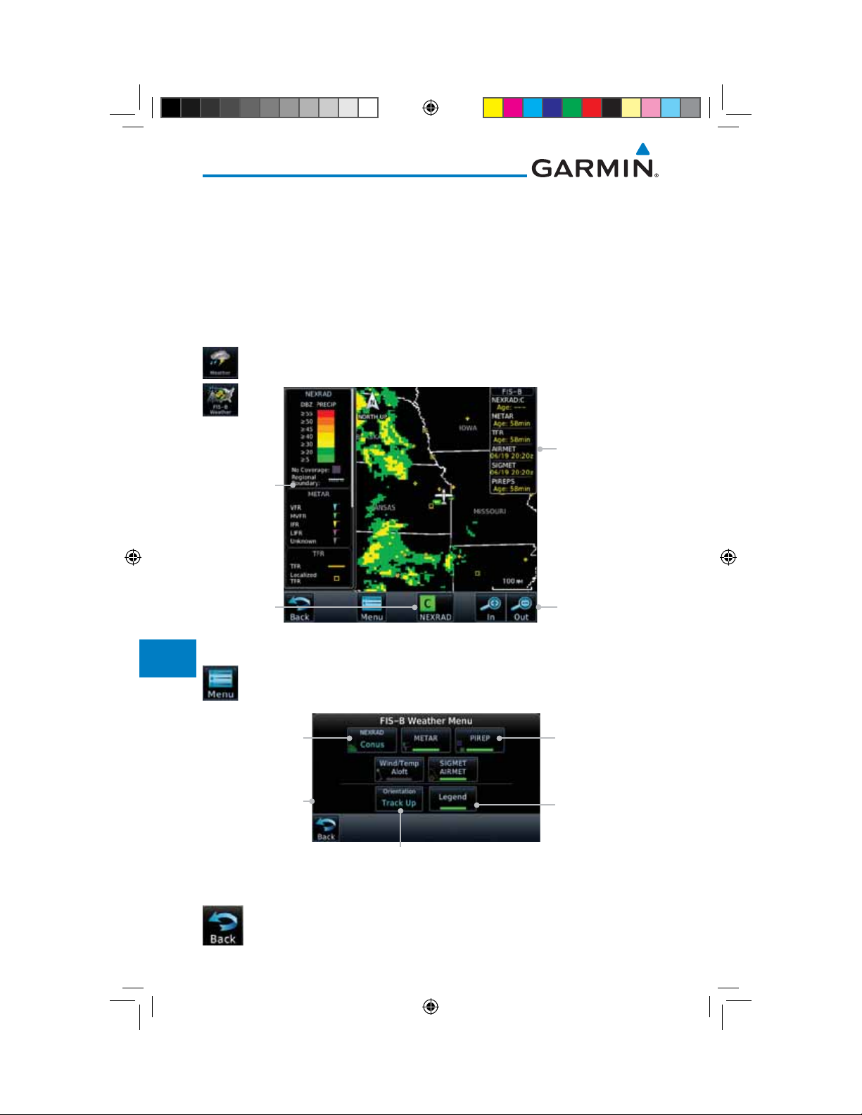
1. From the Home page, touch the Weather key on the Home
page and then touch the FIS-B Weather key (if necessary).
Age Of Selected
Weather Products
Weather
Product
Legends
NEXRAD
Selection
Touch + or - To
Select Map Range
Figure 12-94 FIS-B Weather Page (NEXRAD Key Shown)
2. While viewing the FIS-B weather page, touch the Menu key
to configure the Data Link Weather page.
Touch NEXRAD
Key To Select Off,
CONUS, Regional,
or Combined
NEXRAD
NOTAM On/Off
Display Key
Touch Keys To
Select Weather
Product. Green Bar
Indicates Selected
Product.
Touch Legend Key
To Display Legend
Messages
Weather Overlay
Map Orientation
Symbols
Appendix
Index
190-01007-03-Final.indb 74 7/9/2015 2:08:18 PM
3. Once you selected what items you want to display, touch BACK
12-74
Figure 12-95 FIS-B Weather Data Link Menu
to return to the FIS-B Weather page.
Garmin GTN 725/750 Pilot’s Guide
190-01007-03 Rev. J
12.6.2 FIS-B NEXRAD
Foreword
WSR-88D weather surveillance radar or NEXRAD (NEXt generation RADar) is
a Doppler radar system that has greatly improved the detection of meteorological
events such as thunderstorms, tornadoes, and hurricanes. An extensive network
of NEXRAD stations provides almost complete radar coverage of the continental
Getting
Started
Audio &
Xpdr Ctrl
United States, Alaska, and Hawaii. The unobstructed range of each NEXRAD is
124 nautical miles.
Com/Nav
12.6.2.1 NEXRAD Abnormalities
There are possible abnormalities regarding displayed NEXRAD images. Some,
but not all, causes of abnormal displayed information include:
• Ground Clutter
• Strobes and spurious radar data
• Sun strobes, when the radar antenna points directly at the sun
• Military aircraft deploy metallic dust which can cause alterations in radar
scans
• Interference from buildings or mountains, which may cause shadows
• Scheduled maintenance may put a radar off-line
12.6.2.2 NEXRAD Limitations
Certain limitations exist regarding the NEXRAD radar displays. Some, but
not all, are listed for the user’s awareness:
• The Regional NEXRAD “pixels” are 1.5 minutes (1.5 nautical miles
= 2.78 km) wide by 1 minute (1 nautical miles = 1.852 km) tall. The
CONUS NEXRAD “pixels” are 7.5 minutes (7.5 nautical miles = 13.89
km) wide by 5 minutes (5 nautical miles = 9.26 km) wide. Above 60
degrees of latitude the Regional NEXRAD "pixels" are 3 minutes/nautical
miles. CONUS NEXRAD is not available above 60 degrees of latitude.
The intensity level reflected by the pixel will be the highest level sampled
within the area covered by each pixel.
FPL
Direct-To
Proc
Charts
Wpt Info
Map
Traffic
Terrain
Weather
Nearest
Services/
Music
Utilities
System
Messages
Symbols
Appendix
Garmin GTN 725/750 Pilot’s Guide
190-01007-03-Final.indb 75 7/9/2015 2:08:18 PM
12-75190-01007-03 Rev. J
Index
Foreword
Getting
Started
Audio &
Xpdr Ctrl
Com/Nav
FPL
Direct-To
Proc
Charts
12.6.2.3 NEXRAD Intensity
Colors are used to identify the different NEXRAD echo intensities (reflectivity)
measured in dBZ (decibels of Z). “Reflectivity” is the amount of transmitted power
returned to the radar receiver. Reflectivity (designated by the letter Z) covers a
wide range of signals (from very weak to very strong). So, a more convenient
number for calculations and comparison, a decibel (or logarithmic) scale (dBZ),
is used. The dBZ values increase as the strength of the signal returned to the
radar increases.
12.6.2.4 NEXRAD
When enabled, NEXRAD weather information is shown. Composite data
from all of the NEXRAD radar sites in the United States is shown. This data is
composed of the maximum reflectivity from the individual radar sweeps. The
display of the information is color-coded to indicate the weather level severity.
Refer to the legend for a description of the color code.
Wpt Info
Map
Traffic
Terrain
Weather
Nearest
Services/
Music
Utilities
System
Messages
Symbols
The NEXRAD option has selections of Regional, CONUS, or Combined
NEXRAD. CONUS NEXRAD includes a composite of available NEXRAD radar
imagery across the 48 states. Regional NEXRAD is a composite of available
NEXRAD radar imagery in a local area, showing a more detailed image
than CONUS NEXRAD. FIS-B weather data reception requires line-of-site
communication between the receiver and the ADS-B ground station. Incomplete
Regional and/or CONUS NEXRAD imagery displayed on the MAP and FIS-B
Weather Pages of the affected products is an indicator of poor FIS-B reception.
Affected Areas
Any area in the continental United States (CONUS) or Alaska where the
distance from ADS-B ground stations, or the combined effect of distance and
low altitude, is sufficiently great may cause poor reception. A good source of
information for ground station coverage can be found at:
http://www.faa.gov/nextgen/flashmap/
Reception will improve in some affected areas as the FAA completes the
NextGen ADS-B ground station infrastructure. However, due to line-of-sight
broadcast characteristics, operators with properly installed and functioning
equipment may still receive incomplete FIS-B data when signal reception is
limited by the distance from ground stations combined with a low altitude.
Appendix
12-76
Index
190-01007-03-Final.indb 76 7/9/2015 2:08:18 PM
Garmin GTN 725/750 Pilot’s Guide
190-01007-03 Rev. J
The example below displays an area where FIS-B data is degraded due to
poor reception:
Foreword
Getting
Started
Audio &
Xpdr Ctrl
Com/Nav
FPL
Direct-To
Proc
Charts
Wpt Info
Figure 12-96 Example of Areas Where FIS-B Reception Is Unavailable
Map
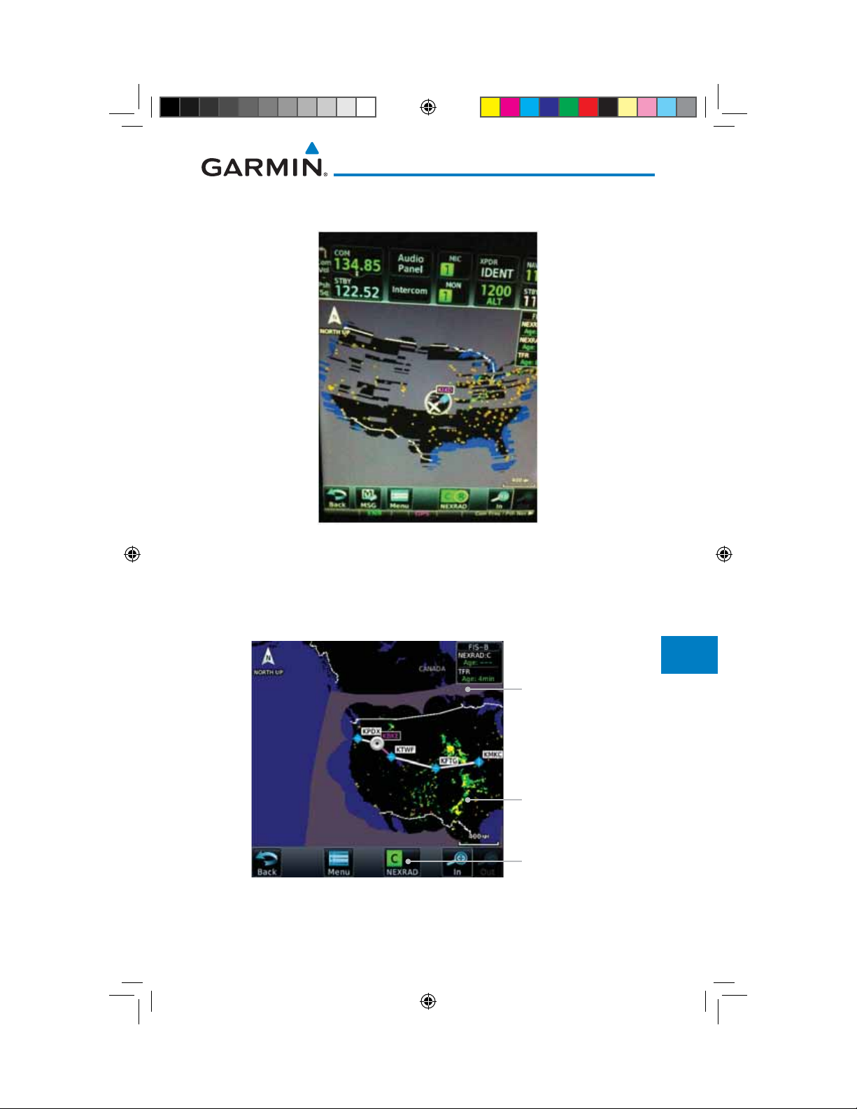
Continental US NEXRAD (CONUS)
The Display CONUS NEXRAD selection shows NEXRAD radar information
for the entire continental United States. CONUS NEXRAD data is updated every
15 minutes.
Out Of CONUS
NEXRAD Coverage
CONUS NEXRAD
Coverage Shown
CONUS Selected
On NEXRAD Key
Figure 12-97 Weather Page With CONUS Displayed
Traffic
Terrain
Weather
Nearest
Services/
Music
Utilities
System
Messages
Symbols
Appendix
Garmin GTN 725/750 Pilot’s Guide
190-01007-03-Final.indb 77 7/9/2015 2:08:19 PM
12-77190-01007-03 Rev. J
Index
Foreword
Getting
Started
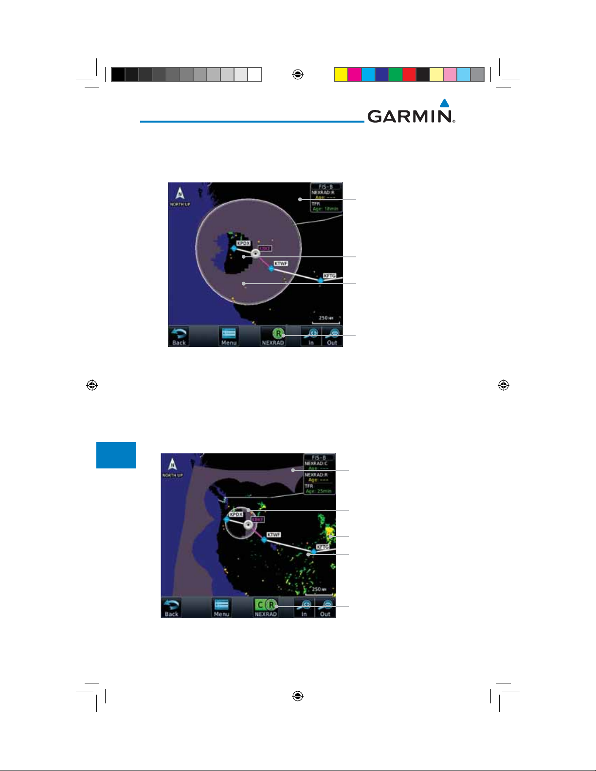
Regional NEXRAD
The Regional NEXRAD selection shows regional NEXRAD radar information
within 500 NM of the aircraft location.
Audio &
Xpdr Ctrl
Com/Nav
FPL
Direct-To
Proc
Charts
Wpt Info
Map
Traffic
Terrain
Weather
Nearest
Out Of Regional
NEXRAD Coverage
Regional NEXRAD
Coverage Shown
Within Regional
NEXRAD Area But
Coverage Not Available
Regional Selected
On NEXRAD Key
Figure 12-98 Weather Page With Regional NEXRAD Displayed
Combined NEXRAD
Regional NEXRAD data and CONUS NEXRAD data are shown together. The
two types of NEXRAD are separated by a white stippled border. This boundary
is updated whenever new Regional or CONUS NEXRAD data is received. The
radius of the boundary is fixed at 150 NM.
Out Of Regional
NEXRAD Coverage
Services/
Music
Utilities
System
Messages
Regional NEXRAD
Boundary Shown
NEXRAD Weather Shown
NEXRAD Weather Shown
CONUS & Regional
Symbols
Selected On NEXRAD Key
Figure 12-99 Weather Page With Combined NEXRAD Displayed
Appendix
12-78
Index
190-01007-03-Final.indb 78 7/9/2015 2:08:19 PM
Garmin GTN 725/750 Pilot’s Guide
190-01007-03 Rev. J
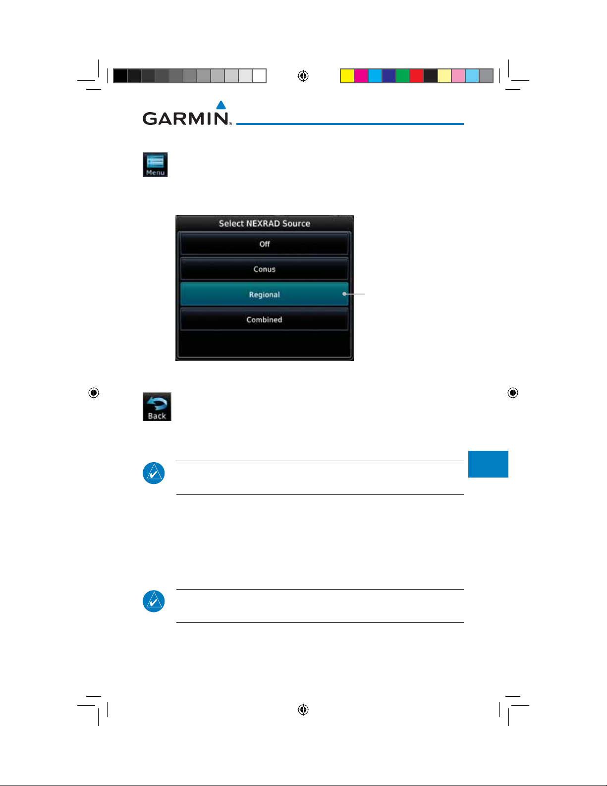
Selecting NEXRAD in the FIS-B Weather Menu
1. While viewing the FIS-B weather page, touch the Menu key
to select the NEXRAD choice.
2. Touch the NEXRAD key to select Off, Regional, CONUS, or
Combined NEXRAD.
Foreword
Getting
Started
Audio &
Xpdr Ctrl
Com/Nav
FPL
Touch the Desired
Direct-To
NEXRAD Source
Proc
Charts
Wpt Info
Figure 12-100 NEXRAD Source Selection
Map
3. Touch the Back key to return to the FIS-B Weather Menu.
Traffic
Terrain
Animating NEXRAD FIS-B
NOTE: Animated NEXRAD functionality is available in software version
6.00 and later.
When Regional or CONUS NEXRAD is enabled for display and more than
two NEXRAD images have been received by the GTN, the NEXRAD display can
Weather
Nearest
Services/
Music
be animated on the FIS-B Weather page. As new NEXRAD images are received,
the GTN will automatically store them for future animation. The GTN can
animate up to six NEXRAD images from oldest to newest, showing each for one
Utilities
System
second and the newest for two seconds.
NOTE: CONUS/Regional Combined NEXRAD cannot be animated. CONUS
Messages
and Regional NEXRAD can only be animated when displayed individually.
Symbols
Appendix
Garmin GTN 725/750 Pilot’s Guide
190-01007-03-Final.indb 79 7/9/2015 2:08:19 PM
12-79190-01007-03 Rev. J
Index
Foreword
Getting
Started
Audio &
Xpdr Ctrl
Com/Nav
1. While viewing the FIS-B Weather page with NEXRAD enabled
for display, press the Play NXRD key to start the NEXRAD
animation.
2. Touch the Stop NXRD key to stop the NEXRAD animation.
The animation will also stop when leaving the page or turning
off NEXRAD on the FIS-B weather page.
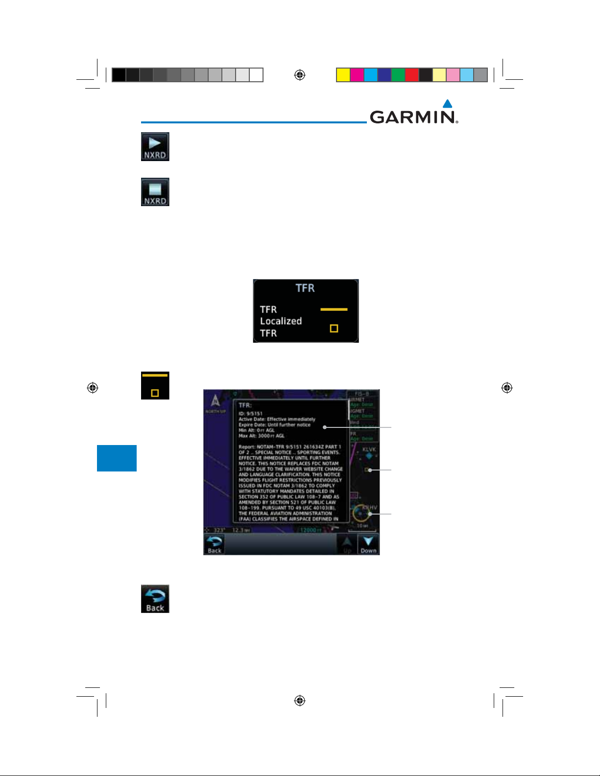
12.6.3 FIS-B TFRs
FPL
Direct-To
Proc
Charts
Wpt Info
Map
Traffic
Terrain
Weather
Nearest
Services/
Music
Temporary Flight Restrictions (TFRs) provide detailed information for local
short term restrictions. The update rate is approximately every 20 minutes.
Figure 12-101 FIS-B TFR Legend
1. Touch a TFR symbol on the Weather page to view details.
TFR Detail
Touch TFR Symbol
To View Details
Touch TFR Symbol
To View Details
Utilities
System
Messages
Symbols
Appendix
Index
190-01007-03-Final.indb 80 7/9/2015 2:08:19 PM
2. Touch the Back key to return to the Weather display.
12-80
Figure 12-102 FIS-B TFR Detail
Garmin GTN 725/750 Pilot’s Guide
190-01007-03 Rev. J
12.6.4 FIS-B METARs
Foreword
When enabled, graphic METARs (METeorological Aviation Reports) are
shown as colored flags at airports that provide METAR reports. Press the
METARs key to enable or disable METARs. Refer to the Legend for a description
of the color code. The update rate is every five minutes.
METAR Symbol Description
VFR (ceiling greater than 3000 ft. AGL and
visibility greater than five miles)
Getting
Started
Audio &
Xpdr Ctrl
Com/Nav
FPL
Marginal VFR (ceiling 1000–3000 ft. AGL
and/or visibility three to five miles)
Direct-To
IFR (ceiling 500 to below 1000 ft. AGL and/or
visibility one mile to less than three miles)
Proc
Low IFR (ceiling below 500 ft. AGL or visibility
less than one mile)
Unknown
Table 12-9 METAR Symbols
1. While viewing the FIS-B weather page, touch the Menu key
Charts
Wpt Info
Map
to select the METAR choice. Touch an airport symbol for more
METAR detail.
Traffic
Product Age
METAR Detail
METAR Flags
Touch Airport For
METAR Detail
Figure 12-103 METARS
Terrain
Weather
Nearest
Services/
Music
Utilities
System
Messages
2. Touch the METAR key to toggle METARS on or off.
Symbols
3. Touch the Back key to return to the FIS-B Weather page.
Garmin GTN 725/750 Pilot’s Guide
190-01007-03-Final.indb 81 7/9/2015 2:08:20 PM
Appendix
12-81190-01007-03 Rev. J
Index
Foreword
Getting
Started
Audio &
Xpdr Ctrl
Com/Nav
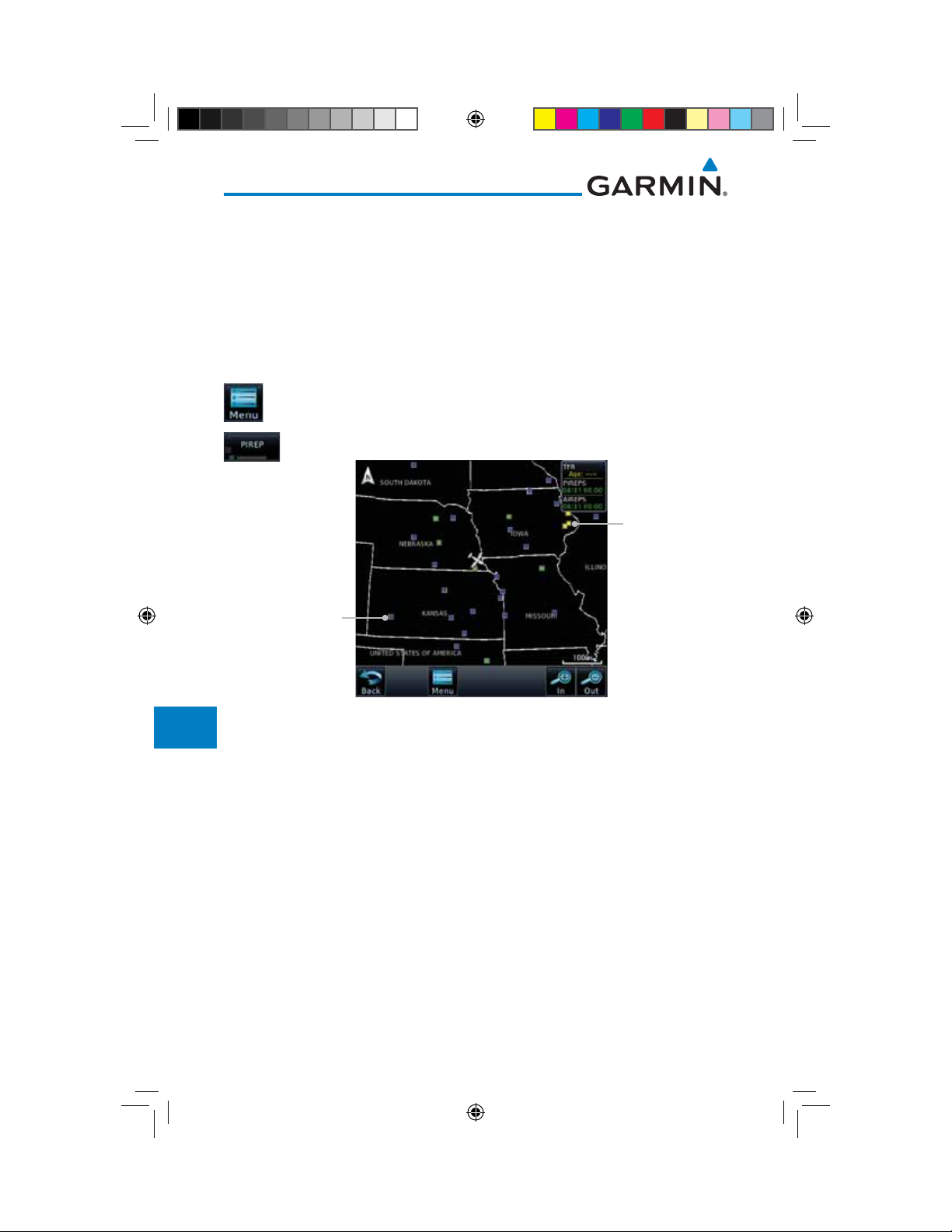
12.6.5 FIS-B PIREPs
Pilot Weather Reports (PIREPs) provide timely weather information. When
significant weather conditions are reported or forecast, Air Traffic Control (ATC)
facilities are required to solicit PIREPs. A PIREP may contain non-forecast
adverse weather conditions, such as low in-flight visibility, icing conditions,
wind shear, and turbulence. PIREPs are issued as either Routine (UA) or Urgent
(UUA). The update rate is approximately every 20 minutes.
FPL
Direct-To
Proc
Charts
Wpt Info
Map
Traffic
Terrain
Weather
Nearest
Services/
Music
1. While viewing the FIS-B weather page, touch the Menu key
to select the PIREP choice.
2. Touch the PIREP key to toggle PIREPs on or off.
Urgent PIREP
Symbol (Yellow).
Touch For Details.
Routine PIREP
Symbol (Blue).
Touch For Details.
Figure 12-104 Weather Display With PIREP Information Active
Utilities
System
Messages
Symbols
Appendix
12-82
Index
190-01007-03-Final.indb 82 7/9/2015 2:08:20 PM
Garmin GTN 725/750 Pilot’s Guide
190-01007-03 Rev. J
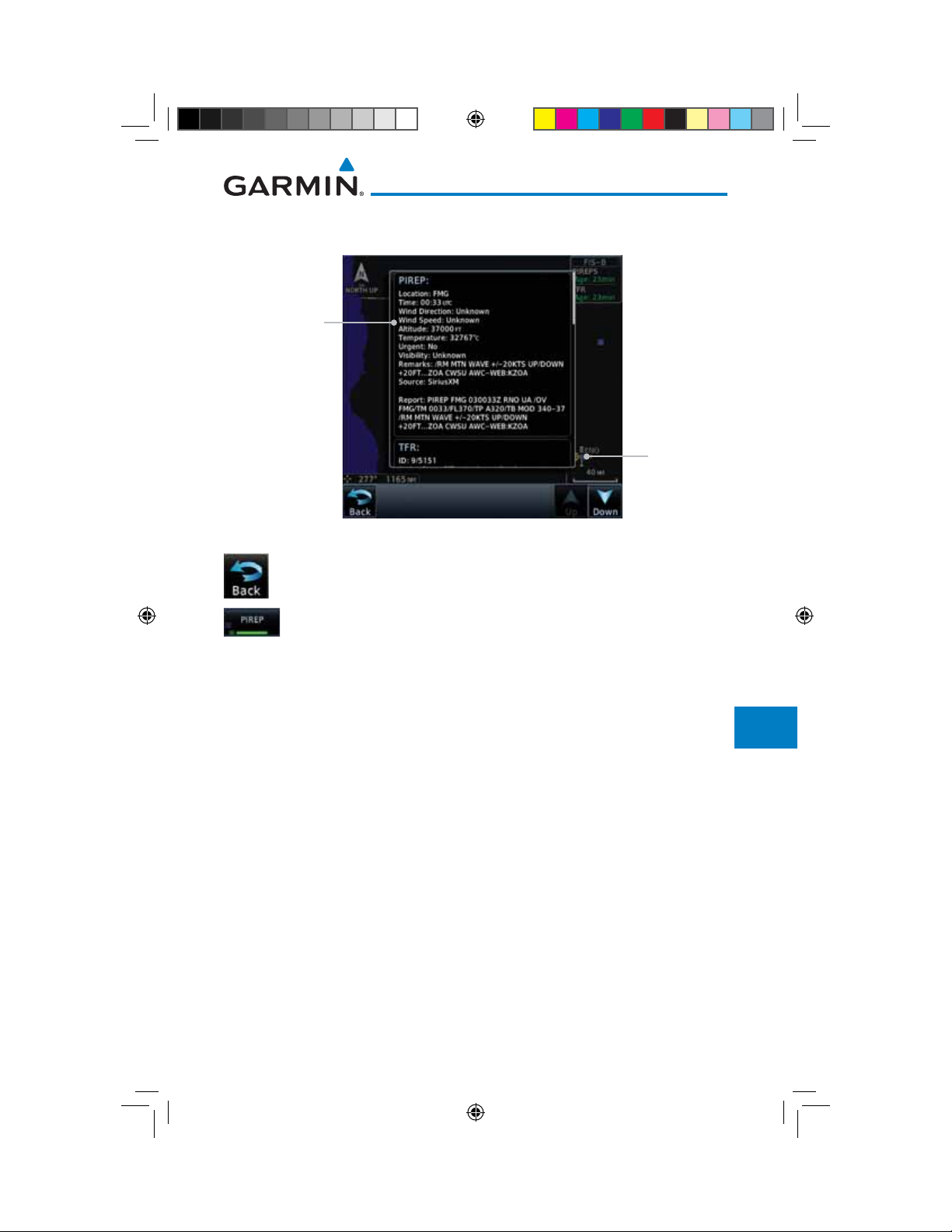
3. Touch a weather information symbol to view details for that
item.
PIREP Details
Foreword
Getting
Started
Audio &
Xpdr Ctrl
Com/Nav
FPL
Selected PIREP
For Detail
Figure 12-105 PIREP Information Detail
4. Touch the Back key to remove the detailed information.
5. Touch the PIREP key again to turn it off.
Direct-To
Proc
Charts
Wpt Info
Map
Traffic
Terrain
Weather
Nearest
Services/
Music
Utilities
System
Messages
Symbols
Appendix
Garmin GTN 725/750 Pilot’s Guide
190-01007-03-Final.indb 83 7/9/2015 2:08:20 PM
12-83190-01007-03 Rev. J
Index
Foreword
Getting
Started
Audio &
Xpdr Ctrl
Com/Nav
FPL
Direct-To
12.6.6 FIS-B Winds and Temperatures Aloft
Winds and Temperatures Aloft data shows the forecast wind speed, direction,
and Temperature at selected altitudes. Altitudes can be selected in increments
from the 1,000 feet up to 53,000 feet. The update rate is every 12 hours.
1. While viewing the Data Link Weather menu, touch the Wind/
Temp Aloft key.
Proc
Charts
Wpt Info
Map
Traffic
Terrain
Weather
Nearest
Services/
Music
Utilities
System
Wind Symbols
Selected Wind Altitude
Touch To Select
Wind Altitude
Figure 12-106 Winds Aloft
2. Touch the WX Aloft ALT – or + keys to increase or decrease
the reporting altitude of the winds aloft in increments. The
selected altitude is shown in a window above the altitude keys.
3. Touch the Wind/Temp Aloft key again to turn it off.
Messages
Figure 12-107 FIS-B Winds Aloft Legend
Symbols
Appendix
12-84
Index
190-01007-03-Final.indb 84 7/9/2015 2:08:20 PM
Garmin GTN 725/750 Pilot’s Guide
190-01007-03 Rev. J
12.6.7 FIS-B SIGMETs and AIRMETs
SIGMETs (SIGnificant METerological Information) and AIRMETs (AIRmen’s
METerological Information) are broadcast for potentially hazardous weather
considered of importance to aircraft. The update rate is approximately every 20
minutes.
Figure 12-108 FIS-B SIGMET/AIRMET Legend
1. While viewing the FIS-B Weather menu, touch the SIGMET/
AIRMET key.
Foreword
Getting
Started
Audio &
Xpdr Ctrl
Com/Nav
FPL
Direct-To
Proc
Charts
Wpt Info
Map
Traffic
Terrain
Surface Winds
Present Position
IFR Line
Turbulence Line
Weather
Nearest
Services/
Music
Utilities
Mountain Obscured
System
Figure 12-109 FIS-B SIGMETs and AIRMETs
Garmin GTN 725/750 Pilot’s Guide
190-01007-03-Final.indb 85 7/9/2015 2:08:20 PM
Messages
Symbols
Appendix
12-85190-01007-03 Rev. J
Index
Foreword
Getting
Started
Audio &
Xpdr Ctrl
Com/Nav
FPL
Direct-To
Proc
Charts
Wpt Info
Map
Traffic
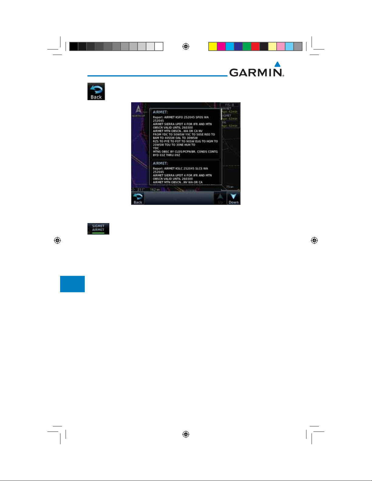
2. Touch a SIGMET/AIRMET line to view details. Touch the Back
key to return to the Weather display.
Figure 12-110 SIGMET and AIRMET Details
3. Touch the SIGMET/AIRMET key again to turn it off.
Terrain
Weather
Nearest
Services/
Music
Utilities
System
Messages
Symbols
Appendix
12-86
Index
190-01007-03-Final.indb 86 7/9/2015 2:08:21 PM
Garmin GTN 725/750 Pilot’s Guide
190-01007-03 Rev. J
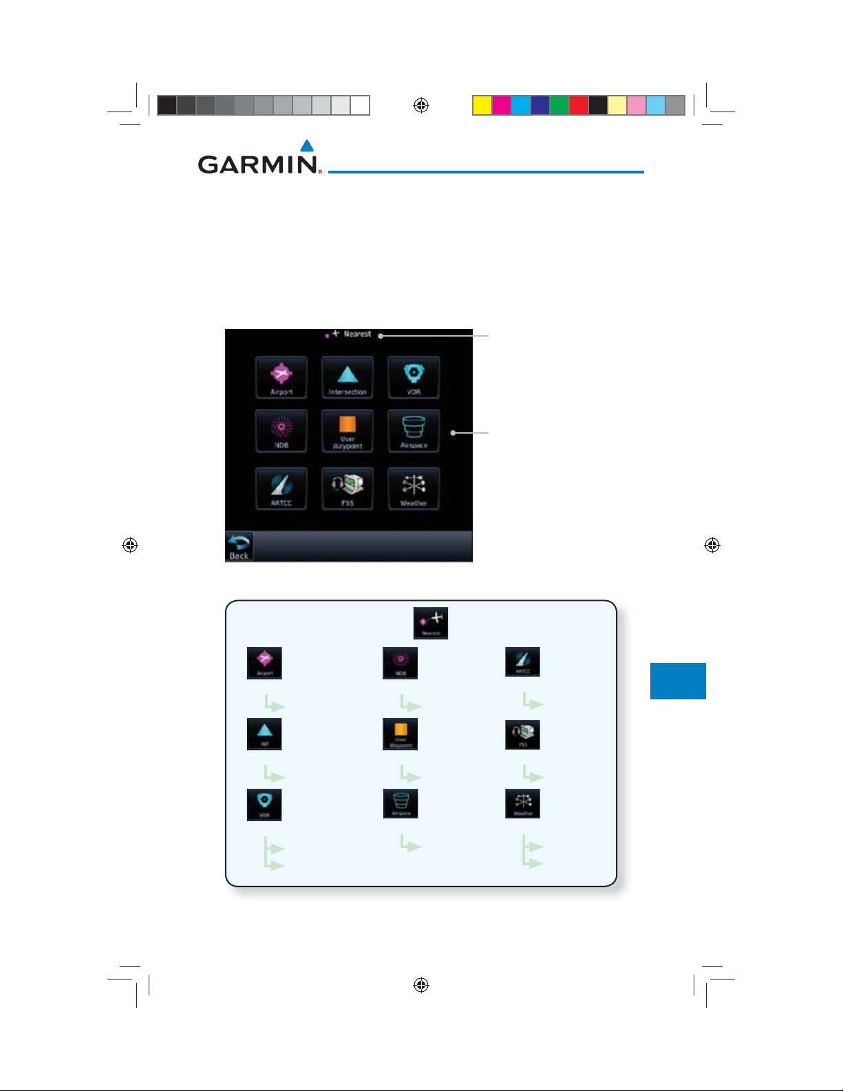
13 NEAREST
Foreword
The Nearest function provides detailed information for the 25 nearest
airports, VORs, NDBs, Intersections and User waypoints within 200 NM of your
current position. In addition, the Nearest pages include the five nearest Flight
Service Station (FSS) and center (ARTCC/FIR) points of communication and
alert you to any Special Use (SUA) or Controlled Airspace you may be in or near.
Getting
Started
Audio &
Xpdr Ctrl
Com/Nav
Function Title
FPL
Direct-To
Nearest Waypoint Types
Figure 13-1 Nearest Page
Proc
Charts
Wpt Info
Map
Traffic
Terrain
Weather
List
List
List
Wpt Info
Wpt Info
Wpt Info
Freq
List
Wpt Info
List
Wpt Info
List
Airspace Info
List
Frequency
List
Frequency
List
Wpt Info
Frequency
Figure 13-2 Nearest Page Functional Map
Garmin GTN 725/750 Pilot’s Guide
190-01007-03-Final.indb 1 7/9/2015 2:08:21 PM
Nearest
Services/
Music
Utilities
System
Messages
Symbols
Appendix
13-1190-01007-03 Rev. J
Index
Foreword
Getting
Started
Audio &
Xpdr Ctrl
Com/Nav
FPL
13.1 Select a Nearest Page
The available waypoint types are shown on the Nearest page. Touch the key
to display the nearest 25 waypoint types (FSS and ARTCC will display up to
five items). Not all 25 nearest waypoints can be displayed on the corresponding
Nearest page at one time. The Nearest page displays detailed information for five
nearest items.
1. On the Home page, touch the Nearest key.
Direct-To
Proc
Charts
Wpt Info
Map
Traffic
Terrain
Weather
Nearest
Services/
Music
Utilities
System
Messages
2. Touch the desired waypoint type (Airport, VOR, etc.) and then
touch the Up and Down keys on the lower right of the display
to navigate through the list of available items. You can also
touch an item on the list and drag your finger to scroll the
list.
3. Touch the highlighted item to view more detailed
information.
4. To navigate Direct-To the waypoint you're viewing, press the
Direct-To key. The waypoint will be loaded into the Waypoint
window of the Direct-To function.
5. Touch the Activate key to navigate directly to that
waypoint.
13.2 Nearest Airport
The Nearest Airport Page displays the identifier, symbol, bearing and distance,
and the length of the longest runway for the 25 nearest airports (within 200 NM
of your present position).
The Nearest Airport Page can be configured to exclude shorter runways or
undesirable runway surface types, so that the corresponding airports do not
appear on the list. You may wish to use this feature to exclude seaplane bases,
heliports, or runway lengths which would be difficult or impossible to land upon.
See System - Setup - Nearest Airport Criteria for information about configuring the
Nearest Airport display criteria.
Symbols
Appendix
13-2
Index
190-01007-03-Final.indb 2 7/9/2015 2:08:21 PM
Garmin GTN 725/750 Pilot’s Guide
190-01007-03 Rev. J
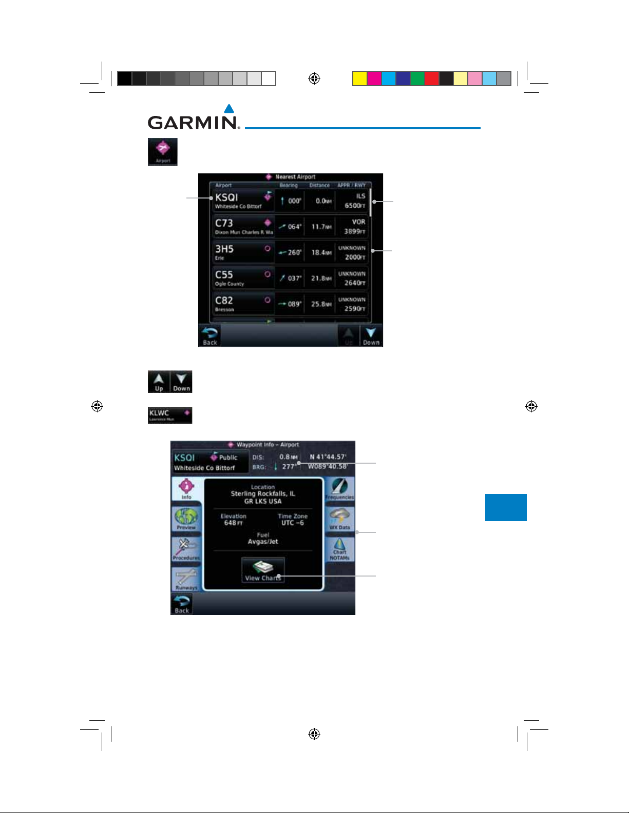
1. While viewing the Nearest function, touch the Airport key. A
list of the nearest 25 airports within 200 NM will be listed.
Airport
Identifier
Figure 13-3 Nearest Airport
Scroll Bar Indicate
More Items On The List
Airport Information
2. Touch the Up and Down keys to scroll through the list.
3. Touch the Airport Identifier key to show the Waypoint Info
page for the selected airport.
Foreword
Getting
Started
Audio &
Xpdr Ctrl
Com/Nav
FPL
Direct-To
Proc
Charts
Wpt Info
Map
Traffic
Distance & Bearing
Terrain
Information
Referenced To
Current Position
Weather
Nearest
Airport
Information
Page
Services/
Music
Utilities
Touch To View Charts
When Available
System
Messages
Figure 13-4 Nearest Airport Waypoint Info
4. Touch one of the tabs (Map, Procedures, Runways, etc.) on the
Symbols
sides of the display for more information about the selected
airport.
Garmin GTN 725/750 Pilot’s Guide
190-01007-03-Final.indb 3 7/9/2015 2:08:22 PM
Appendix
13-3190-01007-03 Rev. J
Index
Foreword
Getting
Started
Audio &
Xpdr Ctrl
Com/Nav
FPL
Direct-To
Proc
Charts
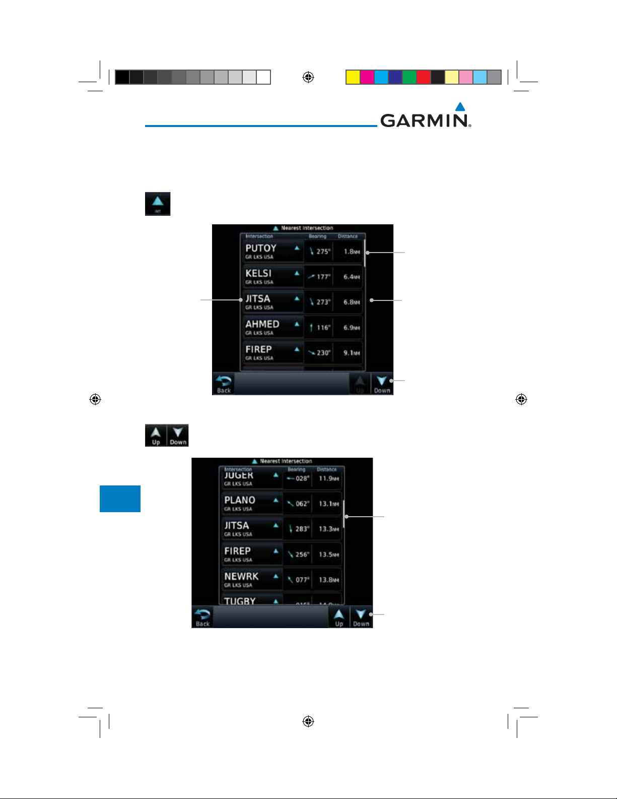
13.3 Nearest Intersection (INT)
The Nearest Intersection Page displays the identifier, symbol, bearing and
distance to the 25 nearest intersections (within 200 NM of your present position).
1. While viewing the Nearest function, touch the INT key. A list
of the nearest 25 Intersections within 200 NM will be listed.
Slider Indicates
More Items On
The List
Intersection
Identifier
Intersection
Information
Wpt Info
Map
Traffic
Terrain
Weather
Nearest
Services/
Music
Utilities
System
Messages
Symbols
Arrow Indicates
More Items On
The List
Figure 13-5 Nearest Intersection List
2. Touch the Up and Down keys to scroll through the list.
Slider Indicates
More Items On
The List
Arrows Indicate
More Items On
The List
Figure 13-6 Scrolling Down the Nearest Intersection List
Appendix
13-4
Index
190-01007-03-Final.indb 4 7/9/2015 2:08:22 PM
Garmin GTN 725/750 Pilot’s Guide
190-01007-03 Rev. J
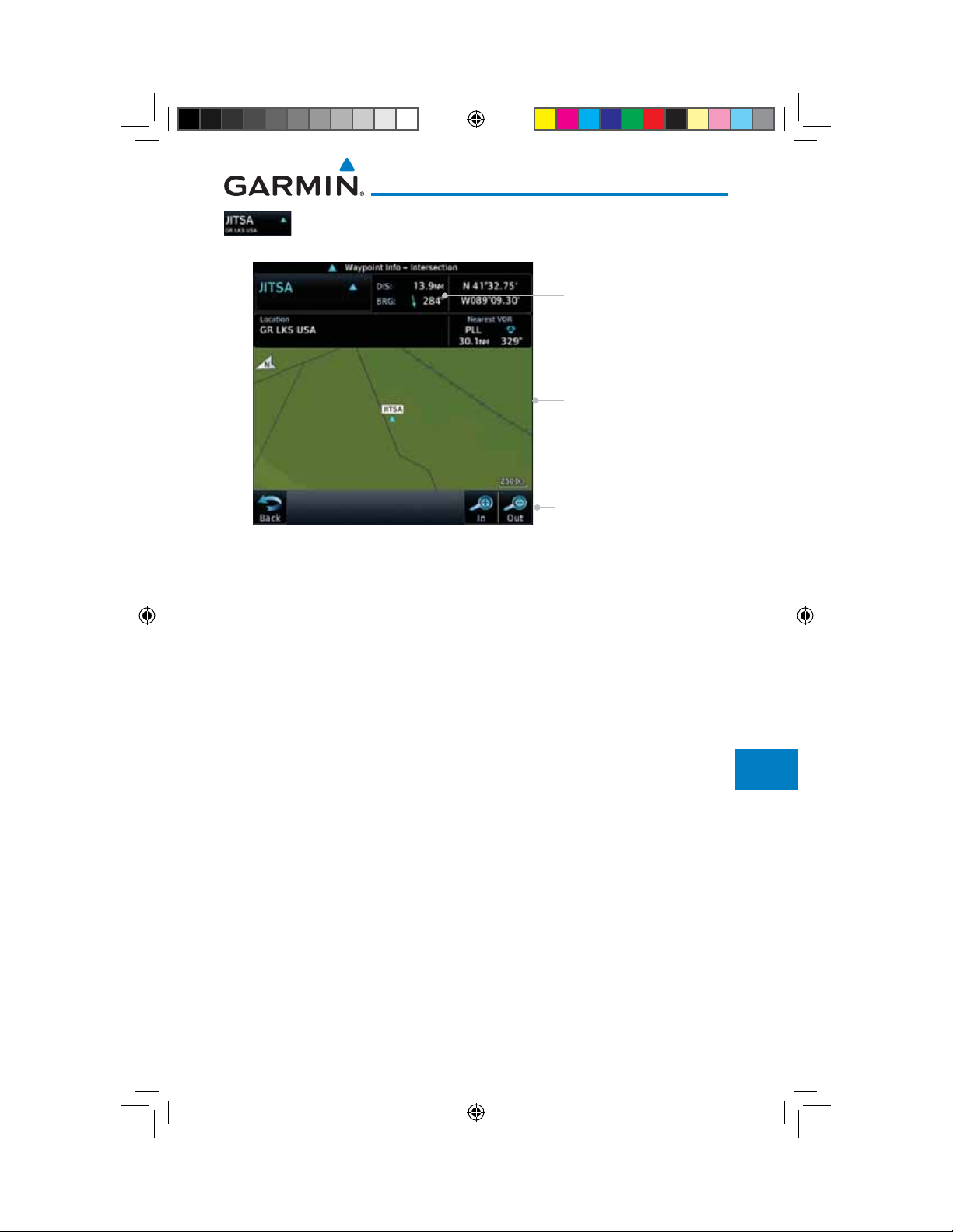
3. Touch the Intersection Identifier key to show the Waypoint
Info page for the selected Intersection.
Distance & Bearing
Information Referenced
To Current Position
Foreword
Getting
Started
Audio &
Xpdr Ctrl
Com/Nav
Intersection
Map Detail
Map Range Keys
Figure 13-7 Nearest Intersection Waypoint Detail
FPL
Direct-To
Proc
Charts
Wpt Info
Map
Traffic
Terrain
Weather
Nearest
Services/
Music
Utilities
System
Messages
Symbols
Appendix
Garmin GTN 725/750 Pilot’s Guide
190-01007-03-Final.indb 5 7/9/2015 2:08:22 PM
13-5190-01007-03 Rev. J
Index
Foreword
Getting
Started
Audio &
Xpdr Ctrl
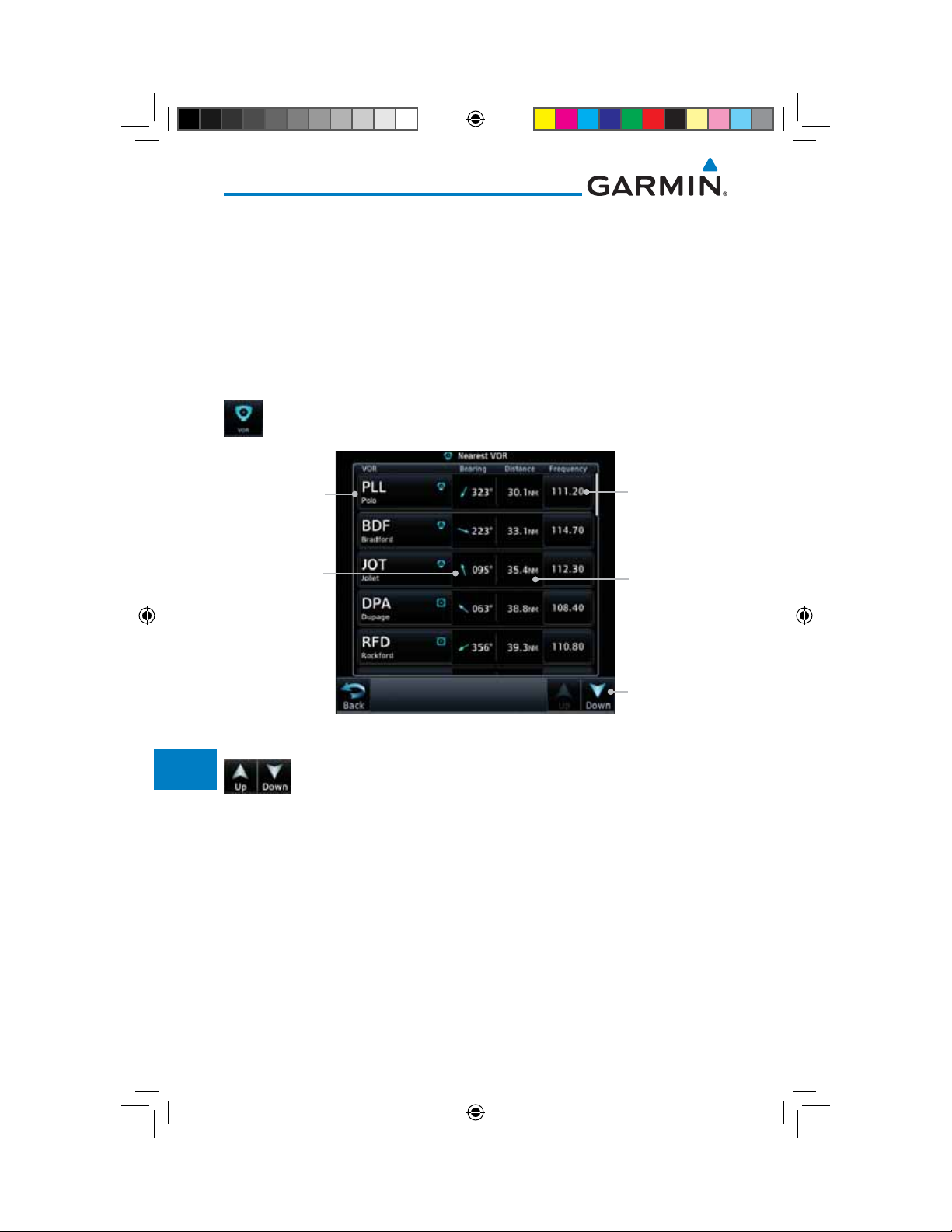
13.4 Nearest VOR
The Nearest VOR Page displays the identifier, symbol, bearing and distance
to the 25 nearest VORs (within 200 NM of your present position). For each VOR
listed, the Nearest VOR Page also indicates the frequency and may be used to
quickly tune the Nav radio to the nearby VOR (GTN 750 only).
Com/Nav
FPL
Direct-To
Proc
Charts
Wpt Info
Map
Traffic
Terrain
Weather
Nearest
Touch the VOR Frequency key to place the frequency in the standby field of the
Nav window. Touch the Nav Active window to flip/flop the Nav frequencies.
1. While viewing the Nearest function, touch the VOR key. A list
of the nearest 25 VORs within 200 NM will be listed.
Nearest VOR
Identifier
Bearing
from Current
Position to VOR
Figure 13-8 Nearest VOR List and Information
Nearest VOR
Frequency
Distance
from Current
Position to VOR
Arrows Indicate
More Items On
The List
2. Touch the Up and Down keys to scroll through the list.
Services/
Music
Utilities
System
Messages
Symbols
Appendix
13-6
Index
190-01007-03-Final.indb 6 7/9/2015 2:08:22 PM
Garmin GTN 725/750 Pilot’s Guide
190-01007-03 Rev. J
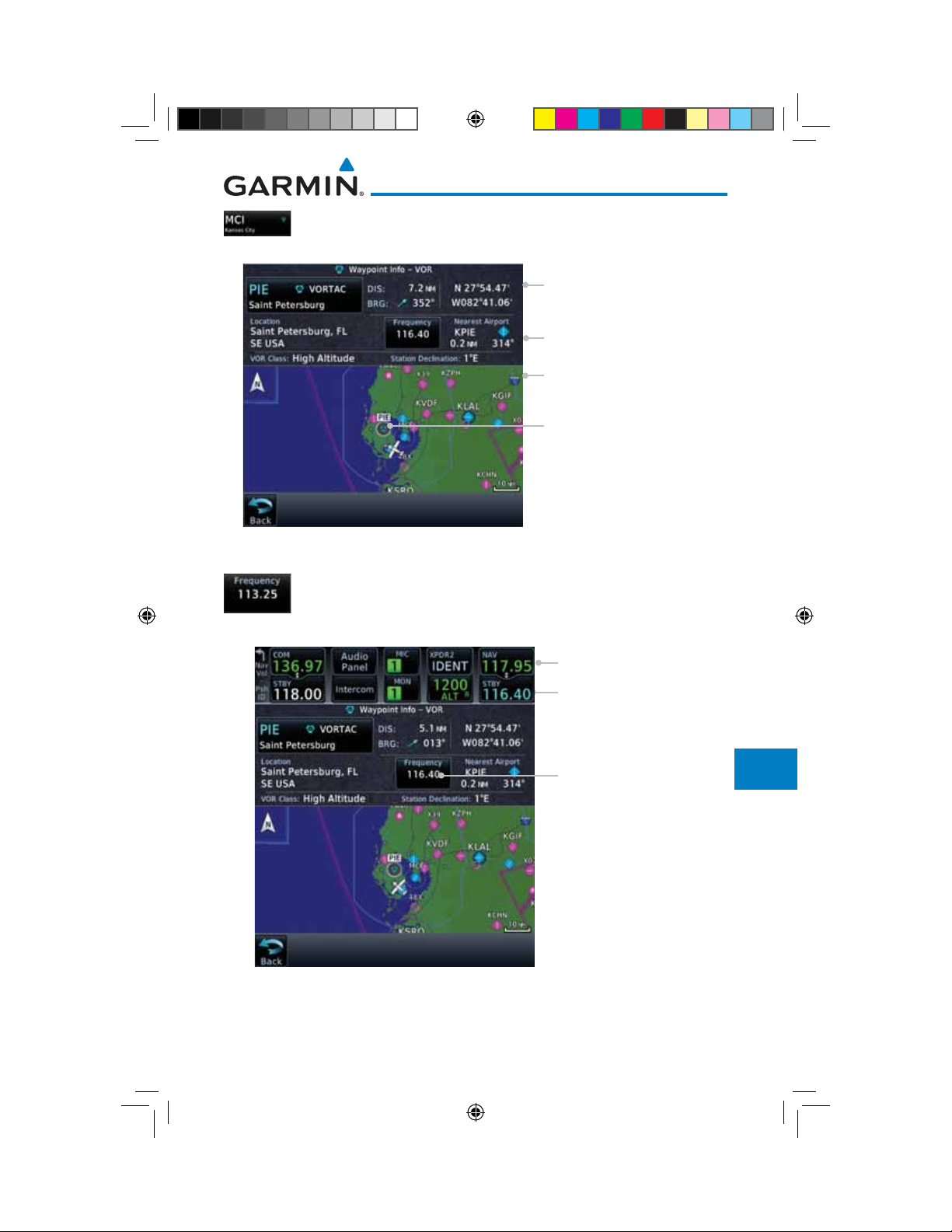
3. Touch the VOR Identifier key to show the Waypoint Info
page for the selected VOR.
VOR Information
Referenced To Current
Position
Additional VOR Information
VOR Map Detail
Foreword
Getting
Started
Audio &
Xpdr Ctrl
Com/Nav
FPL
VOR Location
Figure 13-9 Nearest VOR Waypoint Information
4. Touch the Frequency key on this page or from the Nearest
VOR List page to place the selected frequency into the Nav
Standby window.
Touch to Flip/Flop
VOR Frequency Inserted
Into Standby Window.
VOR Frequency
Direct-To
Proc
Charts
Wpt Info
Map
Traffic
Terrain
Weather
Nearest
Services/
Music
Utilities
System
Messages
Figure 13-10 Nearest VOR Frequency Entry
Garmin GTN 725/750 Pilot’s Guide
190-01007-03-Final.indb 7 7/9/2015 2:08:23 PM
Symbols
Appendix
13-7190-01007-03 Rev. J
Index
 Loading...