

Garmin G300 for Cessna SkyCatcher, G300 Pilot's Manual

G300
Pilot’s Guide


SYSTEM OVERVIEW
FLIGHT INSTRUMENTS
EIS
COM INTERFACE
GPS NAVIGATION
FLIGHT PLANNING
HAZARD AVOIDANCE
ADDITIONAL FEATURES
INTEGRATED AUTOPILOT
ANNUNCIATIONS & ALERTS
APPENDIX
INDEX


Copyright © 2009 - 2010, 2012 Garmin Ltd. or its subsidiaries. All rights reserved.
This manual reflects the operation of System Software version 0006.20 or later. Some differences
in operation may be observed when comparing the information in this manual to earlier or later
software versions.
Garmin International, Inc., 1200 East 151st Street, Olathe, Kansas 66062, U.S.A.
Toll free: 800/800.1020 or 866/739.5687 Tel: 913/397.8200 Fax: 913/397.8282
Garmin AT, Inc., 2345 Turner Road SE, Salem, OR 97302, U.S.A.
Tel: 503/391.3411 Fax 503/364.2138
Garmin (Europe) Ltd, Liberty House, Bulls Copse Road, Hounsdown Business Park,
Southampton, SO40 9RB, U.K.
Tel: 44/0870.8501241 Fax: 44/0870.8501251
Garmin Corporation, No. 68, Jangshu 2nd Road, Shijr, Taipei County, Taiwan
Tel: 886/02.2642.9199 Fax: 886/02.2642.9099
Web Site Address: www.garmin.com
Except as expressly provided herein, no part of this manual may be reproduced, copied,
transmitted, disseminated, downloaded or stored in any storage medium, for any purpose
without the express written permission of Garmin. Garmin hereby grants permission to
download a single copy of this manual and of any revision to this manual onto a hard drive or
other electronic storage medium to be viewed for personal use, provided that such electronic
or printed copy of this manual or revision must contain the complete text of this copyright
notice and provided further that any unauthorized commercial distribution of this manual or
any revision hereto is strictly prohibited.
Garmin®, FliteCharts®, SafeTaxi®, and MapSource® are registered trademarks of Garmin Ltd.
or its subsidiaries. G300™ is a trademark of Garmin Ltd. or its subsidiaries. These trademarks
may not be used without the express permission of Garmin.
Jeppesen® is a registered trademark of Jeppesen, Inc.
NavData™ is a trademark of Jeppesen, Inc.
SiriusXM Weather and Radio services are provided by SiriusXM Satellite Radio, Inc.
March 2012 190-00921-00 Rev. E Printed in the U.S.A

Garmin G300 Pilot’s Guide
190-00921-00 Rev. E
Warnings, Cautions & Notes
WARNING: Navigation and terrain separation must NOT be predicated
upon the use of the terrain function. The G300 Terrain Proximity feature
is NOT intended to be used as a primary reference for terrain avoidance
and does not relieve the pilot from the responsibility of being aware of
surroundings during flight. The Terrain Proximity feature is only to be used
as an aid for terrain avoidance and is not certified for use in applications
requiring a certified terrain awareness system. Terrain data is obtained
from third party sources. Garmin is not able to independently verify the
accuracy of the terrain data.
WARNING: The displayed minimum safe altitudes (MSAs) are only
advisory in nature and should not be relied upon as the sole source of
obstacle and terrain avoidance information. Always refer to current
aeronautical charts for appropriate minimum clearance altitudes.
WARNING: The altitude calculated by G300 GPS receivers is geometric
height above Mean Sea Level and could vary significantly from the
altitude displayed by pressure altimeters. Always use pressure altitude
displayed by the G300 PFD when determining or selecting aircraft
altitude.
WARNING: Do not use outdated database information. Databases used
in the G300 system must be updated regularly in order to ensure that
the information remains current. Pilots using any outdated database do
so entirely at their own risk.
WARNING: XM WX Satellite Weather should not be used for hazardous
weather penetration. Weather information is approved only for weather
avoidance, not penetration.
WARNING: NEXRAD weather data is to be used for long-range planning
purposes only. Due to inherent delays in data transmission and the
relative age of the data, NEXRAD weather data should not be used for
short-range weather avoidance.

Garmin G300 Pilot’s Guide
190-00921-00 Rev. E
Warnings, Cautions & Notes
WARNING: The illustrations in this guide are only examples. Never
use the G300 to attempt to penetrate a thunderstorm. Both the
FAA Advisory Circular, Subject: Thunderstorms, and the Aeronautical
Information Manual (AIM) recommend avoiding “by at least 20 miles any
thunderstorm identified as severe or giving an intense radar echo.”
WARNING: To reduce the risk of unsafe operation, carefully review and
understand all aspects of the G300 Pilot’s Guide documentation and the
Pilot’s Operating Handbook of the aircraft. Thoroughly practice basic
operation prior to actual use. During flight operations, carefully compare
indications from the G300 to all available navigation sources, including
the information from other NAVAIDs, visual sightings, charts, etc. For
safety purposes, always resolve any discrepancies before continuing
navigation.
WARNING:
Because of variation in the earth’s magnetic field, operating
the G300 within the following areas could result in loss of reliable attitude
and heading indications. North of 72° North latitude at all longitudes;
South of 70° South latitude at all longitudes; North of 65° North latitude
between longitude 75° W and 120° W. (Northern Canada); North of 70°
North latitude between longitude 70° W and 128° W. (Northern Canada);
North of 70° North latitude between longitude 85° E and 114° E. (Northern
Russia); South of 55° South latitude between longitude 120° E and 165° E.
(Region south of Australia and New Zealand)
WARNING: The Garmin G300 has a very high degree of functional
integrity. However, the pilot must recognize that providing monitoring
and/or self-test capability for all conceivable system failures is not
practical. Although unlikely, it may be possible for erroneous operation
to occur without a fault indication shown by the G300. It is thus the
responsibility of the pilot to detect such an occurrence by means of
cross-checking with all redundant or correlated information available
in the cockpit.
WARNING: For safety reasons, G300 operational procedures must be
learned on the ground.

Garmin G300 Pilot’s Guide
190-00921-00 Rev. E
Warnings, Cautions & Notes
WARNING: The United States government operates the Global Positioning
System and is solely responsible for its accuracy and maintenance. The
GPS system is subject to changes which could affect the accuracy and
performance of all GPS equipment. Portions of the Garmin G300 utilize
GPS as a precision electronic NAVigation AID (NAVAID). Therefore, as
with all NAVAIDs, information presented by the G300 can be misused
or misinterpreted and, therefore, become unsafe.
WARNING: The data contained in the terrain and obstacle databases
comes from government agencies. Garmin accurately processes and
cross-validates the data, but cannot guarantee the accuracy and
completeness of the data.
WARNING: Do not use basemap (land and water data) information for
primary navigation. Basemap data is intended only to supplement other
approved navigation data sources and should be considered as an aid
to enhance situational awareness.
CAUTION: The display uses a lens coated with a special anti-reflective
coating that is very sensitive to skin oils, waxes, and abrasive cleaners.
CLEANERS CONTAINING AMMONIA WILL HARM THE ANTI-REFLECTIVE
COATING. It is very important to clean the lens using a clean, lint-free
cloth and an eyeglass lens cleaner that is specified as safe for antireflective coatings.
CAUTION: The Garmin G300 does not contain any user-serviceable parts.
Repairs should only be made by an authorized Garmin service center.
Unauthorized repairs or modifications could void both the warranty and
the pilot’s authority to operate this device under FAA/FCC regulations.
NOTE: All visual depictions contained within this document, including
screen images of the G300 panel and displays, are subject to change
and may not reflect the most current G300 system and aviation
databases. Depictions of equipment may differ slightly from the actual
equipment.

Garmin G300 Pilot’s Guide
190-00921-00 Rev. E
Warnings, Cautions & Notes
NOTE: This product, its packaging, and its components contain chemicals
known to the State of California to cause cancer, birth defects, or
reproductive harm. This notice is being provided in accordance with
California’s Proposition 65. If you have any questions or would like
additional information, please refer to our web site at www.garmin.com/
prop65.
NOTE: Interference from GPS repeaters operating inside nearby hangars
can cause an intermittent loss of attitude and heading displays while the
aircraft is on the ground. Moving the aircraft more than 100 yards away
from the source of the interference should alleviate the condition.
NOTE: Use of polarized eyewear may cause the flight displays to appear
dim or blank.
NOTE: Temporary Flight Restriction (TFR) data is provided by the FAA
and may not be updated outside of normal business hours. Confirm
data currency through alternate sources and contact your local FSS for
interpretation of TFR data.

Garmin G300 Pilot’s Guide
190-00921-00 Rev. E
Warnings, Cautions & Notes
Blank Page

Garmin G300 Pilot’s Guide
190-00921-00 Rev. E RR-1
Part Number Change Summary
190-00921-00 Initial release
Rev Date Description
A February,
2009
Production Release
B August,
2009
Added System Software Version 2.30 parameters
C August,
2010
System Software Version 2.30 - 2.40 changes:
• Added Density Altitude to the list of selectable Data Bar Fields
• Added an advisory message to indicate when the GDU is in Demo
Mode
• Added advisory message to indicate anomalous magnetometer data
System Software Version 2.40-2.50 changes:
• Added Altitude Alerter to PFD
• Changed PFD to declutter Data Fields in unusual attitudes
System Software Version 2.50-2.60 changes:
• Added message to indicate if config module is missing
• Added warning text to Weight & Balance Page
System Software Version 2.60-2.70:
• Added support for Integrated Autopilot control and display via the PFD
Page
• Added PFD Setup Menu
• Added second Bearing Pointer to PFD HSI
• Added menu option to XM Page to allow selection of a specific chan-
nel number
System Software Version 2.70-3.00:
• Added Synthetic Vision
• Added mach number to configurable Data Fields
System Software Version 3.00-3.10:
• Added ability to import/export flight plans using the SD card
• Added Softkeys to Nearest Airports Page to quickly show/hide private
airports and heliports
• Removed ability to adjust Roll Mode reference using the FMS Joystick
System Software Version 3.10-3.20:
• Added ability to display checklist files from SD Card
• Added ability to log data to SD Card
• Added ability to export Track Log and User Waypoints to SD Card

Garmin G300 Pilot’s Guide
190-00921-00 Rev. E
RR-2
D September,
2010
Clerical Changes
E March,
2012
System Software Version 3.20-4.00:
• Added support for geo-referenced FliteCharts
• Added Softkey to Terrain Page to quickly enabled/disable terrain alerts
System Software Version 4.00-4.10:
• Added support for displaying flight time in databar
System Software Version 4.10 - 5.00 :
• Added persistent sky/ground display to PFD
• Added automatic sync of altimeter setting to local terrain elevation
• Added display of displaced runway threshold distance to Airport
Review Page
• Added menu option and softkey to the FPL VNAV Page to force a
capture of a VNAV profile
• Added Sirius/XM warning text
System Software Version 5.10 - 6.00 :
• Added pathways
System Software Version 6.00 - 6.10 :
• Added baro minimums altitude reference bug and audio alert to PFD
• Changed CRS Softkey on PFD Page to indicate which course it controls.
System Software Version 6.10 - 6.20 :
• Added ability to change the layout of PFD1 between full-screen and
split-screen in normal mode via the Display Setup Page
• Added arrows to PFD terrain messages to indicate terrain alerts which
are outside the Synthetic Vision field of view
• Added softkey to Terrain page

Garmin G300 Pilot’s Guide
190-00921-00 Rev. E i
Table of Contents
Section 1 System Overview .................................................................1
1.1 Line Replaceable Units ..................................................................................1
G300 Standard Panel .............................................................................................4
G300 Upgraded Panel .............................................................................................5
1.2 Display Overview ..........................................................................................6
1.3 Secure Digital (SD) Cards .............................................................................. 7
1.4 G300 Controls ................................................................................................8
1.5 System Power-up ......................................................................................... 10
1.6 System Operation ........................................................................................12
Display Operation ..................................................................................................12
G300 System Annunciations ..................................................................................14
AHRS Operation ....................................................................................................14
1.7 Accessing System Functionality ................................................................. 16
Menus ..................................................................................................................16
Data Entry .............................................................................................................17
Pages ....................................................................................................................19
Main Page Softkeys ...............................................................................................24
Flight Planning Softkeys.........................................................................................31
Nearest Page Softkeys ...........................................................................................32
1.8 Accessing the Information (INFO) Page ..................................................... 33
Viewing GPS Receiver Status .................................................................................33
Position .................................................................................................................36
Data Fields and Layout (Dual Display - MFD) ..........................................................38
1.9 System Settings ............................................................................................39
Data Bar Fields ......................................................................................................40
Display ..................................................................................................................41
Sound ...................................................................................................................43
Units .....................................................................................................................45
Date & Time ..........................................................................................................46
Position .................................................................................................................47
Alarms ..................................................................................................................47
Setting Airport Criteria ...........................................................................................49
Section 2 Flight Instruments .............................................................. 51
2.1 Flight Instruments ....................................................................................... 51
Airspeed Indicator .................................................................................................53
Attitude Indicator ..................................................................................................54
Altimeter ...............................................................................................................55
Altitude Alerting ....................................................................................................59
Vertical Speed Indicator (VSI) .................................................................................60
VNAV Indicator .....................................................................................................60
Horizontal Situation Indicator (HSI) ........................................................................61
Heading Strip and Turn Rate Indicator ....................................................................66
OBS Mode ............................................................................................................66

Garmin G300 Pilot’s Guide
190-00921-00 Rev. E
ii
Table of Contents
2.2 Supplemental Flight Data ...........................................................................68
Outside Air Temperature ........................................................................................68
Wind Data ............................................................................................................68
2.3 Vertical Navigation (VNAV) ......................................................................... 69
Using the VNAV Feature ........................................................................................70
Section 3 Engine Indication System ..................................................73
3.1 EIS Display & ENG Page ..............................................................................73
Section 4 COM Interface ....................................................................77
4.1 Auto-tuning Frequencies ............................................................................ 77
Section 5 GPS Navigation ................................................................... 81
5.1 Introduction ................................................................................................. 81
Compass Arc .........................................................................................................81
5.2 Using Map Displays ..................................................................................... 82
Map Page Setup ....................................................................................................83
Map Range ...........................................................................................................87
Map Panning ........................................................................................................88
Measuring Bearing and Distance ...........................................................................90
Topography ...........................................................................................................91
Satellite View ........................................................................................................92
Map Symbols ........................................................................................................92
5.3 Airways ......................................................................................................... 93
5.4 Waypoints .....................................................................................................96
Nearest Information ............................................................................................101
Weather Information ...........................................................................................103
Intersections .......................................................................................................104
NDBs .......................................................................................................105
VORs ..................................................................................................................106
User Waypoints ...................................................................................................107
5.5 Airspace ..................................................................................................... 111
Airspace Alert Messages ......................................................................................112
Smart Airspace ....................................................................................................113
5.6 Direct-to Navigation .................................................................................113
Section 6 Flight Planning ..................................................................117
6.1 Introduction ............................................................................................... 117
Flight Plan Data Fields .........................................................................................118
6.2 Flight Plan Creation ..................................................................................119
6.3 Flight Plan Storage ....................................................................................121
6.4 Flight Plan Activation ................................................................................122
6.5 Flight Plan Editing ..................................................................................... 123

Garmin G300 Pilot’s Guide
190-00921-00 Rev. E iii
Table of Contents
Adding Waypoints to an Existing Flight Plan .........................................................123
Editing Flight Plan Speed, Fuel, and/OR Name ......................................................125
Copying Flight Plans ............................................................................................127
Deleting Flight Plans ...........................................................................................127
Inverting a Flight Plan .........................................................................................129
Importing/Exporting Flight Plans ..........................................................................130
6.6 Approaches ................................................................................................ 131
Selecting an Approach .........................................................................................132
Activating Vectors-to-Final ...................................................................................135
6.7 Trip Planning .............................................................................................. 136
Section 7 Hazard Avoidance ............................................................. 137
7.1 XM WX Satellite Weather .........................................................................137
XM Datalink Weather Advisory ............................................................................137
XM WX Satellite Weather Products ......................................................................139
Using XM WX Satellite Weather Products .............................................................150
7.2 Terrain .........................................................................................................154
Synthetic Vision ...................................................................................................155
Terrain Information ..............................................................................................155
Terrain Views .......................................................................................................156
Terrain Settings ...................................................................................................158
Terrain Alerts .......................................................................................................159
Section 8 Additional Features .......................................................... 163
8.1 Synthetic Vision (SVX) ............................................................................... 164
Synthetic Vision Operation ...................................................................................166
8.2 SafeTaxi ...................................................................................................... 175
SafeTaxi Cycle Number and Revision ....................................................................176
8.3 FliteCharts® ............................................................................................... 177
Aircraft Symbol....................................................................................................179
Chart Range ........................................................................................................179
FliteCharts Cycle Number and Expiration Date .....................................................180
8.4 AOPA Data .................................................................................................. 181
8.5 SiriusXM Radio Entertainment (Optional) ...............................................182
Activating SiriusXM Satellite Radio Services .........................................................182
Using SiriusXM Radio ...........................................................................................184
8.6 Electronic Checklists (Optional) ............................................................... 188
8.7 Flight Data Logging ..................................................................................189
Section 9 Integrated Autopilot (Optional) ......................................191
9.1 Integrated Autopilot Operation...............................................................192
Controls ..............................................................................................................192
G300 Autopilot Status BOX .................................................................................196
Integrated Autopilot Modes .................................................................................197

Garmin G300 Pilot’s Guide
190-00921-00 Rev. E
iv
Table of Contents
9.2 Vertical Modes ........................................................................................... 198
Pitch Hold Mode (PIT)..........................................................................................198
Selected Altitude Capture mode (ALTS) ................................................................200
Altitude Hold Mode (ALT) ....................................................................................201
Vertical Speed Mode (VS) ....................................................................................203
Vertical Navigation Mode (VNAV) ........................................................................205
9.3 Lateral Modes ............................................................................................ 209
Roll Hold Mode (ROL) ..........................................................................................209
Heading Mode (HDG) ..........................................................................................211
Navigation Mode (GPS) .......................................................................................212
Changing the Selected Course (OBS Mode) ..........................................................214
9.4 Integrated Autopilot Alerts ......................................................................214
Section 10 Annunciations & Alerts .................................................. 215
10.1 Miscellaneous Message Advisories ........................................................215
10.2 System Status Messages (INFO Page) ...................................................217
10.3 Aural Alerts .............................................................................................. 221
Terrain ................................................................................................................221
10.4 PFD Annunciations and Alerting Functions ........................................... 222
CAS Messages ....................................................................................................222
Terrain Annunciations ..........................................................................................223
Integrated Autopilot Alerts (Optional) ..................................................................224
Section 11 Appendices ..................................................................... 227
Appendix A: Data Field Options ..................................................................... 227
Appendix B: Utilities ........................................................................................231
Flight Log ............................................................................................................231
Track Log ............................................................................................................233
Heading Line .......................................................................................................237
Weight & Balance ...............................................................................................238
EPE Circle ...........................................................................................................240
Proximity Waypoints ............................................................................................241
Appendix C: SD Card Use and Databases ......................................................243
Installing and Removing SD Cards .......................................................................243
G300 Databases .................................................................................................244
Updating G300 Databases ..................................................................................247
Exporting Track Logs and User Waypoints .............................................................249
Importing/Exporting Flight Plans ..........................................................................250
Flight Data Logging .............................................................................................250
Appendix D: Map Datum and Location Formats ..........................................251
Map Datums .......................................................................................................251
Location Formats .................................................................................................251

Garmin G300 Pilot’s Guide
190-00921-00 Rev. E v
Table of Contents
Appendix E: Abnormal operation...................................................................253
Loss of GPS Position ............................................................................................253
G300 System Failure Annunciations .....................................................................254
Reversionary Mode ..............................................................................................255
Synthetic Vision Troubleshooting ..........................................................................255
Unusual Attitudes ................................................................................................256
Appendix F: Display Symbols .........................................................................257
VFR Symbols .......................................................................................................257
IFR Symbols ........................................................................................................258
Airspace Symbols ................................................................................................260
Appendix G: Glossary ...................................................................................... 263
Appendix H: License Agreement and Warranty ............................................ 269
Contact Garmin...................................................................................................269
Software License Agreement ................................................................................269
Limited Warranty .................................................................................................269
AOPA Airport Directory Notice .............................................................................270
SiriusXM Satellite Radio Service Agreement ..........................................................271
Weather Data Warranty .......................................................................................271

Garmin G300 Pilot’s Guide
190-00921-00 Rev. E
vi
Table of Contents
Blank Page

Garmin G300 Pilot’s Guide
190-00921-00 Rev. E 1
System Overview
System
Overview
Flight
Instruments EIS
COM
Interface
GPS
Navigation
Flight
Planning
Hazard
Avoidance
Additional
Features
Integrated
Autopilot Annun/Alerts Appendix Index
SECTION 1 SYSTEM OVERVIEW
The G300 System presents flight instrumentation, position, navigation,
communication, and identification information to the pilot using one (single
display) or two (dual display) 7” Wide VGA (800x480) flat-panel color display(s).
1.1 LINE REPLACEABLE UNITS
The system is distributed across the following Line Replaceable Units (LRUs):
• Garmin Display Unit (GDU) 375 (with XM)
– Single Display: Split Primary Flight Display (PFD) & Multi Function Display
(MFD)
– Multiple Displays: MFD (recommended)
• GDU 370 (without XM)
– Single Display: Split Primary Flight Display (PFD) & Multi Function Display
(MFD)
– Multiple Displays: MFD, PFD, or split-screen
GDU 37X
Garmin G300 Pilot’s Guide
190-00921-00 Rev. E
2
System Overview
System
Overview
Flight
InstrumentsEIS
COM
Interface
GPS
Navigation
Flight
Planning
Hazard
Avoidance
Additional
Features
Integrated
AutopilotAnnun/AlertsAppendixIndex
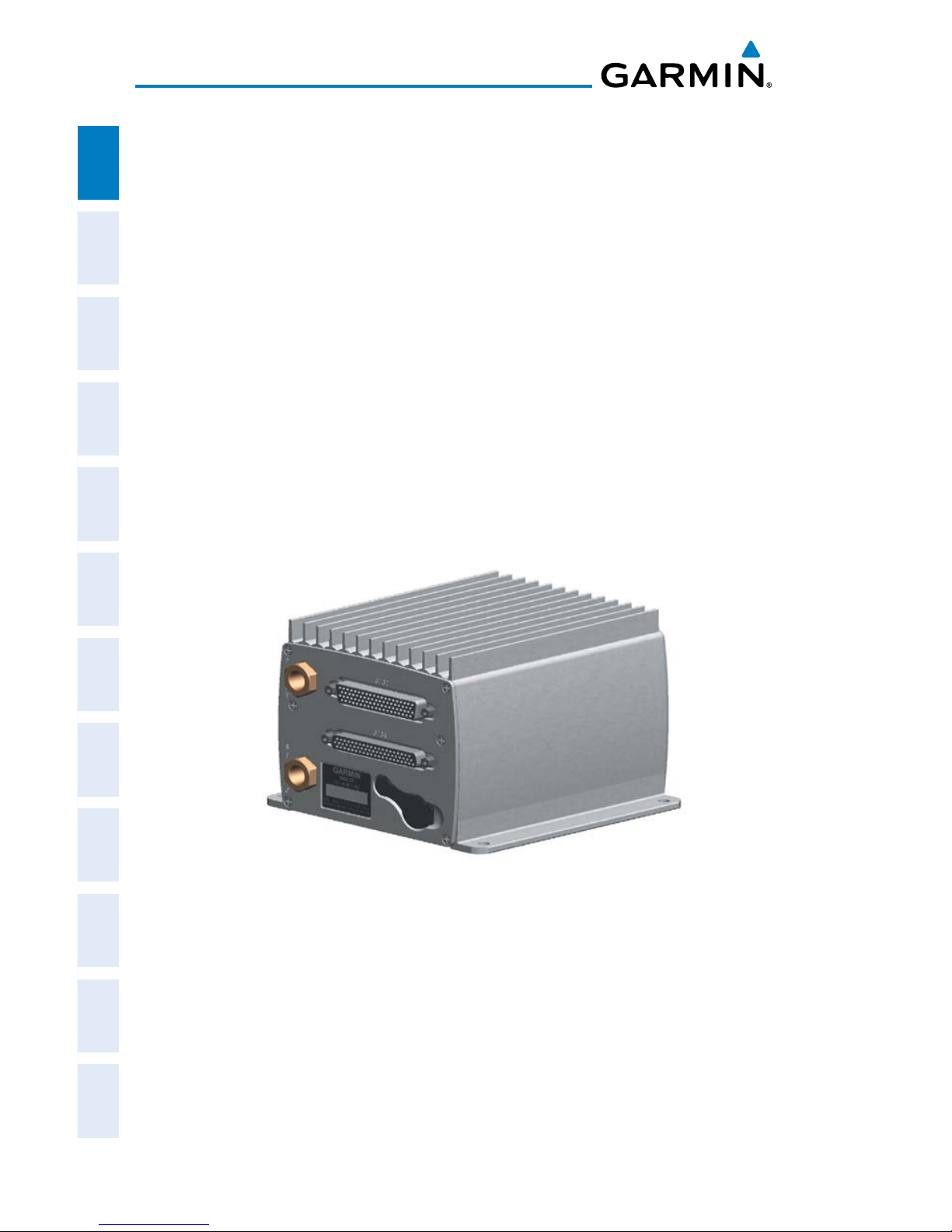
• GSU 73
– Garmin Sensor Unit sub-system for the G300 (Air Data Computer (ADC),
Engine/Airframe Unit, and the Attitude and Heading Reference System
(AHRS))
– ADC: Processes data from the pitot-static system and outside air
temperature (OAT) sensor.
– Engine/Airframe Unit: Receives and processes signals from the
engine and airframe sensors.
– AHRS: Provides aircraft attitude and heading information to the
PFD. The AHRS contains advanced sensors (including accelerometers and rate sensors) and interfaces with the Magnetometer to
obtain magnetic field information, with the ADC to obtain air data,
and with the GDU to obtain GPS information. AHRS operation is
discussed later in this section.
GSU 73

Garmin G300 Pilot’s Guide
190-00921-00 Rev. E 3
System Overview
System
Overview
Flight
Instruments EIS
COM
Interface
GPS
Navigation
Flight
Planning
Hazard
Avoidance
Additional
Features
Integrated
Autopilot Annun/Alerts Appendix Index
• GMU 44
– Magnetometer: Measures the local magnetic field and sends data to the
AHRS for processing to determine aircraft magnetic heading. This unit
receives power directly from the AHRS and communicates with it via an
RS-485 digital interface.
GMU 44
• GTP 59
– Temperature Probe: Provides raw air temperature data.
GTP 59
Garmin G300 Pilot’s Guide
190-00921-00 Rev. E
4
System Overview
System
Overview
Flight
InstrumentsEIS
COM
Interface
GPS
Navigation
Flight
Planning
Hazard
Avoidance
Additional
Features
Integrated
AutopilotAnnun/AlertsAppendixIndex
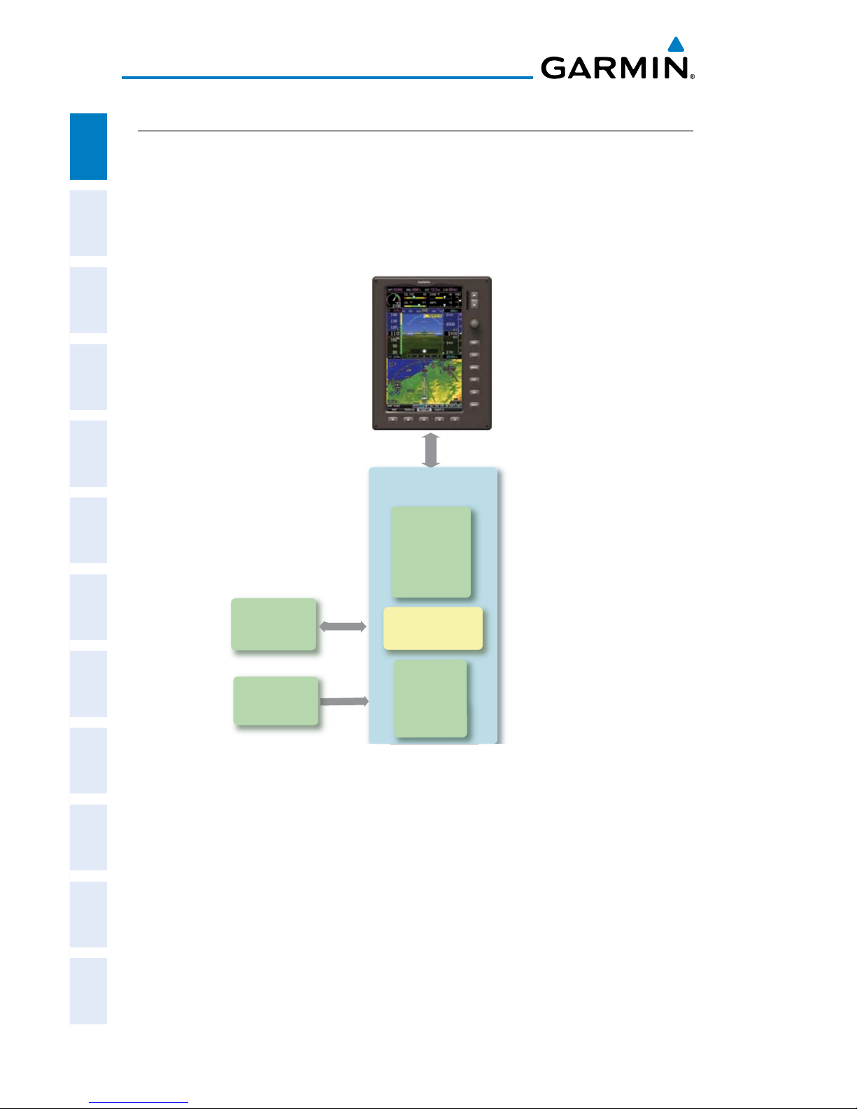
G300 STANDARD PANEL
In the standard split-screen configuration, the Primary Flight Display (PFD)
and the Multi Function Display (MFD) are displayed in split-screen mode on a
single GDU.
G300 Standard Panel
(Single Display)
GMU 44
Magnetometer
Heading
GSU 73
Garmin Sensor Unit
GDU 370 or 375 (XM)
AHRS
Attitude
Heading
Rate of Turn
Slip/Skid
GTP 59
Temperature
Probe
Air Data
Computer
OAT
Airspeed
Altitude
Ver tical Speed
Engine/Airframe
Unit
Split PFD/MFD
Garmin G300 Pilot’s Guide
190-00921-00 Rev. E 5
System Overview
System
Overview
Flight
Instruments EIS
COM
Interface
GPS
Navigation
Flight
Planning
Hazard
Avoidance
Additional
Features
Integrated
Autopilot Annun/Alerts Appendix Index
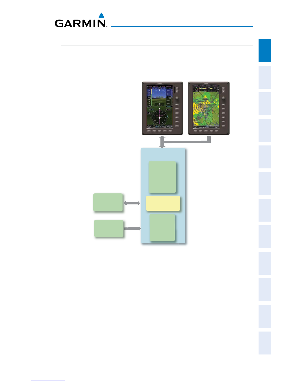
G300 UPGRADED PANEL
With the upgraded ‘dual display’ configuration the left GDU is configured as a
PFD and the right GDU is configured as a MFD.
G300 Upgraded Panel
(Dual Display)
GMU 44
Magnetometer
Heading
GSU 73
Garmin Sensor Unit
GDU 370 (PFD)
AHRS
Heading
Attitude
Rate of Turn
Slip/Skid
GTP 59
Temperature
Probe
Air Data
Computer
OAT
Airspeed
Altitude
Ver tical Speed
Engine/Airframe
Unit
GDU 375 (MFD)
Garmin G300 Pilot’s Guide
190-00921-00 Rev. E
6
System Overview
System
Overview
Flight
InstrumentsEIS
COM
Interface
GPS
Navigation
Flight
Planning
Hazard
Avoidance
Additional
Features
Integrated
AutopilotAnnun/AlertsAppendixIndex
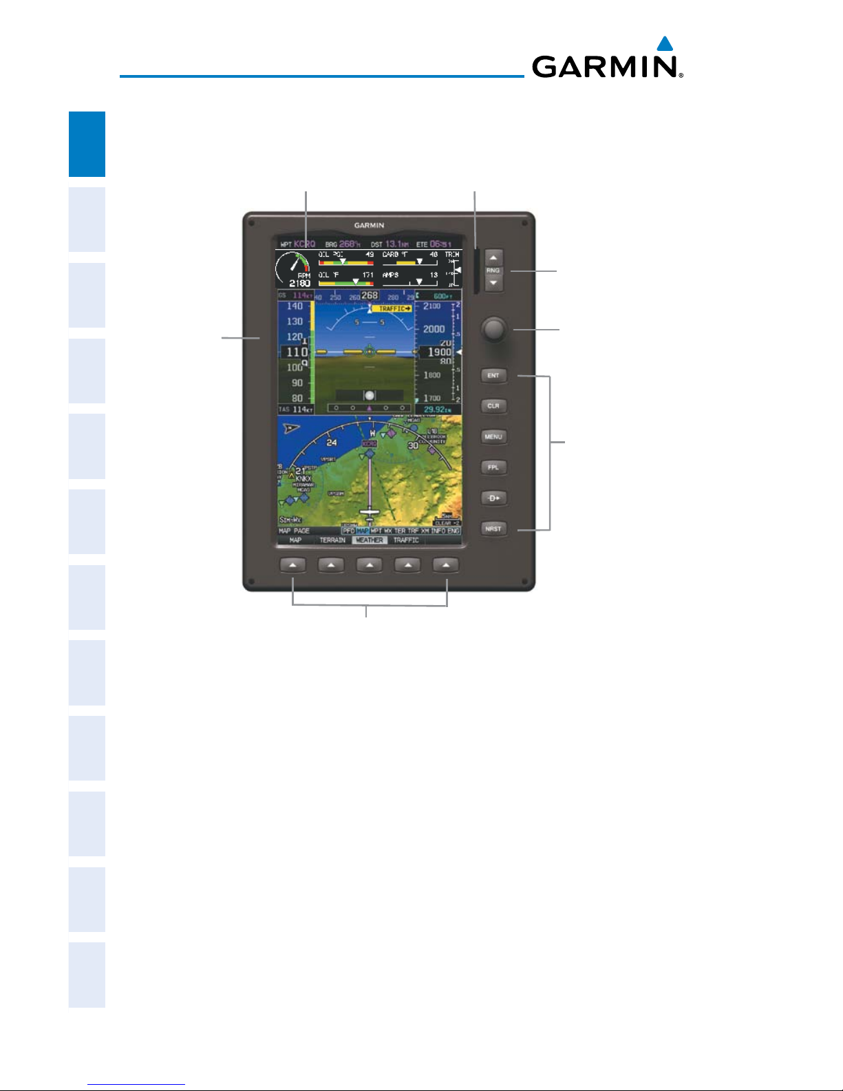
1.2 DISPLAY OVERVIEW
Unit Overview (Single Display Map Page)
Softkeys
Hardkeys
FMS Joystick
Range (RNG) Key
SD Card Slot
Display Bezel
7” WVGA (800x480)
Color Display

Garmin G300 Pilot’s Guide
190-00921-00 Rev. E 7
System Overview
System
Overview
Flight
Instruments EIS
COM
Interface
GPS
Navigation
Flight
Planning
Hazard
Avoidance
Additional
Features
Integrated
Autopilot Annun/Alerts Appendix Index
1.3 SECURE DIGITAL (SD) CARDS
NOTE:
Refer to Appendix C for more information on SD Card use and
databases.
The G300 data card slot uses Secure Digital (SD) cards and is located on the
upper right side of the display bezel(s). The SD card can be used for software
updates, checklist files, flight data logging, exporting Track Logs/User Waypoints,
and Importing/Exporting Flight Plans.
Installing an SD Card:
1)
Insert the SD card in the SD card slot with the card contacts facing the
display (the card should be flush with the face of the bezel).
2)
To eject the card, gently press on the SD card to release the spring
latch.
Display Bezel SD Card Slot
SD Card Slot
Garmin G300 Pilot’s Guide
190-00921-00 Rev. E
8
System Overview
System
Overview
Flight
InstrumentsEIS
COM
Interface
GPS
Navigation
Flight
Planning
Hazard
Avoidance
Additional
Features
Integrated
AutopilotAnnun/AlertsAppendixIndex
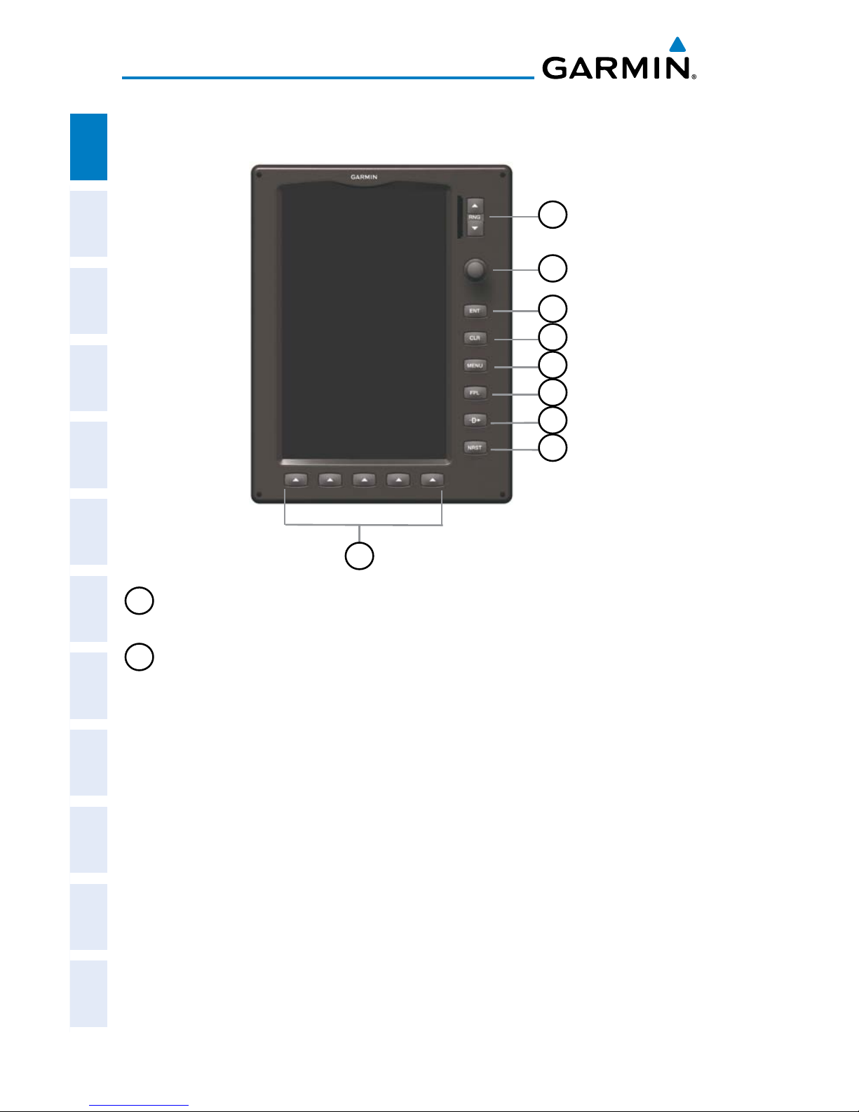
1.4 G300 CONTROLS
9
3
2
4
5
6
7
8
1
1
RNG Key Press to increase or decrease the viewing range of the map
Press to increase or decrease the HSI Scale on the PFD or PFD Page
2
FMS
Joystick
Press the FMS Joystick to toggle input focus between user interaction
with the current page and the page navigation bar
Turn the FMS Joystick clockwise to access a drop down menu within
the highlighted field
Turn the FMS Joystick to change the selected value within the
highlighted field
Move the FMS Joystick (up, down, left, or right) to highlight a field
Move the FMS Joystick (up, down, left, right, or diagonally) to move
the map pointer
With the HDG or HDG/ROLL Softkey selected, press and hold the FMS
Joystick to sync to the current heading
With the appropriate autopilot mode selected, move the FMS Joystick
(up/down) to adjust the mode reference for Vertical Speed, Altitude
Hold, and Pitch Hold modes, or move the FMS Joystick (left/right) to
decrease the mode reference for Roll Hold mode.

Garmin G300 Pilot’s Guide
190-00921-00 Rev. E 9
System Overview
System
Overview
Flight
Instruments EIS
COM
Interface
GPS
Navigation
Flight
Planning
Hazard
Avoidance
Additional
Features
Integrated
Autopilot Annun/Alerts Appendix Index
3
ENT Key Press to confirm menu selection or data entry
Press to acknowledge messages
Press and hold to mark a waypoint
4
CLR Key
Press to cancel an entry, revert to the previous value in a data entry
field or remove menus
Press and hold to return to the default page
5
MENU
Key
Press once to view the Page Menu
Press twice to view the Main Menu
Press a third time to clear the Main Menu
6
FPL Key Press to display the Flight Plan Page
7
Direct-To
Key
Press to activate the Direct-To function, enter a destination
waypoint and establish a direct course to the selected destination
8
NRST
Key
Press to display the Nearest Page for viewing the nearest airports,
intersections, NDBs, VORs, waypoints, frequencies, and airspaces
9
Softkey
Selection
Keys
Press to select softkey shown above the bezel key on the display
Garmin G300 Pilot’s Guide
190-00921-00 Rev. E
10
System Overview
System
Overview
Flight
InstrumentsEIS
COM
Interface
GPS
Navigation
Flight
Planning
Hazard
Avoidance
Additional
Features
Integrated
AutopilotAnnun/AlertsAppendixIndex
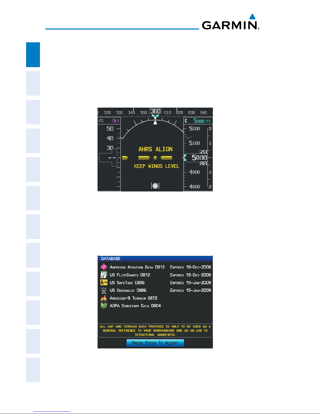
1.5 SYSTEM POWER-UP
During system initialization, the AHRS displays the message ‘AHRS ALIGN, KEEP
WINGS LEVEL’ over the attitude indicator. The AHRS should display valid attitude
and heading fields typically within the first minute of power-up. The AHRS can
align itself both while taxiing and during level flight.
System Initialization
Current database information is displayed during power-up including valid
operating dates, cycle number, and database type. When this information has
been reviewed for currency (to ensure that no databases have expired), the pilot
is prompted to continue.
Database Information
Pressing the ENT Key acknowledges this information.

Garmin G300 Pilot’s Guide
190-00921-00 Rev. E 11
System Overview
System
Overview
Flight
Instruments EIS
COM
Interface
GPS
Navigation
Flight
Planning
Hazard
Avoidance
Additional
Features
Integrated
Autopilot Annun/Alerts Appendix Index
After acknowledgement of the database information, the pilot is prompted to
acknowledge a datalink weather advisory.
Datalink Weather Advisory
Pressing the ENT Key acknowledges this information.
Garmin G300 Pilot’s Guide
190-00921-00 Rev. E
12
System Overview
System
Overview
Flight
InstrumentsEIS
COM
Interface
GPS
Navigation
Flight
Planning
Hazard
Avoidance
Additional
Features
Integrated
AutopilotAnnun/AlertsAppendixIndex
1.6 SYSTEM OPERATION
This section discusses normal and reversionary G300 display operation, G300
System Annunciations, and AHRS Operation.
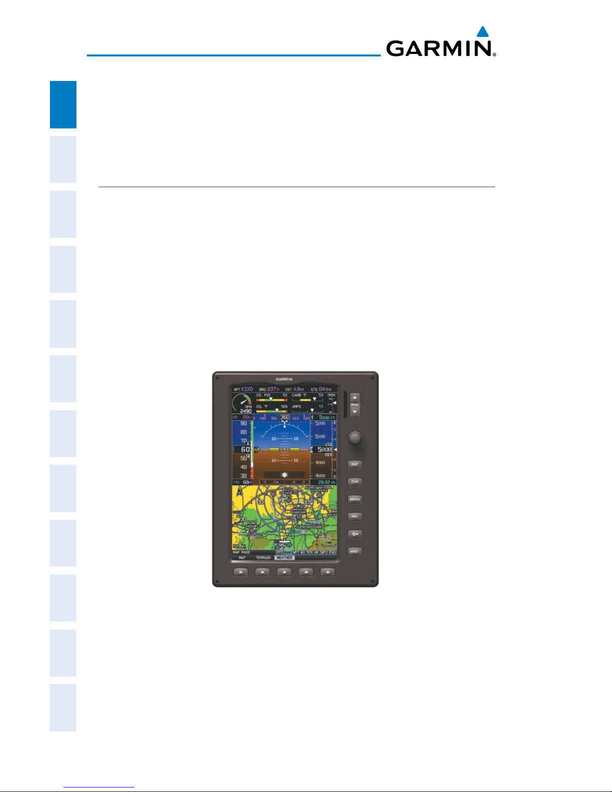
DISPLAY OPERATION
In normal operating mode, the PFD presents graphical flight instrumentation
(attitude, heading, airspeed, altitude, vertical speed), replacing the traditional
flight instrument cluster.
• Single Display
– The single display PFD occupies the top portion of the display at all times,
and a full display PFD can be accessed by navigating to the PFD Page (see
Section 1.6, Accessing System Functionality).
– The single display MFD occupies the bottom portion of the display.
G300 Split-Screen Normal Mode
 Loading...