

Page 1

Survey Pro Software
Field Proven Data Collection
with Survey Pro Software
Page 2

Simplicity, Reliabilty,
and Security
Spectra Precision® Survey Pro™ software
gives you a complete set of tools for all
your survey projects. It’s fast, easy to
use and reliable, so you can work more
productively in the eld. Use Survey
Pro on a range of eld proven Spectra
Precision rugged data collectors.
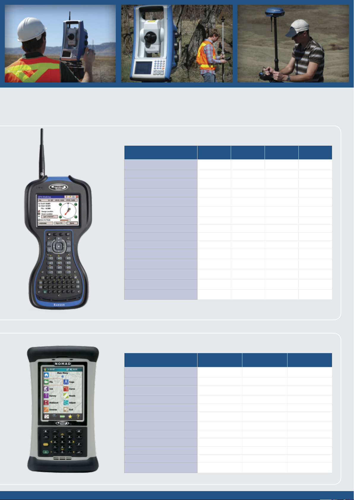
Spectra Precision
Ranger 3 Data Collector
The third generation Spectra Precision
Ranger™ Data Collector offers a large, bright
touch-screen, full alpha-numeric, easy to
operate, keypad, and is packed with the
features surveyors depend on. Built rugged,
it meets rigorous MIL-STD-810G military
standard for drops, vibration, humidity and
extreme temperatures, and with an IP67
rating, it’s designed to keep your investment
and your data safe. The Ranger 3 features
Survey Pro and Windows Mobile 6.5, with
the capability to run the mobile version of all
your favorite programs including Excel and
Outlook. Integrated Bluetooth capabilities
let you connect to eld equipment without
cables. The Ranger 3 comes standard
with 8 GB of onboard memory for storing
data. Move your data fast and easily using
a SDHC card, Bluetooth, USB cable, or
USB memory stick, Wi-Fi, or GSM WWAN
modem. Choose from four different models
of the Ranger with the features that best
suit your needs and your budget. They’re all
power-packed, so there’s no wrong choice.
®
Spectra Precision Nomad
900 Data Collector
The Spectra Precision® Nomad® Data
Collector, packed with functionality, is an
extremely powerful and full-featured rugged
data collector. In addition to meeting
rigorous military standards the Nomad
uses a high speed 806 MHz processor, a
longlife, 5200 mAh lithium-ion battery, and
integrated wireless capabilities like GPS,
Wi-Fi 802.11g, and Bluetooth for power
and exibility. The Nomad features a high
resolution, sunlight-visible full VGA display
that shows graphics and maps in crisp
detail plus a backlit numeric keypad. The
Nomad is available in a range of solutions
from the powerful 900XC, the traditional
900LD and the economical 900B, each
packed with features and benets to suit
your specic needs.
SURVEY PRO
Page 3
Spectra Precision Ranger 3 Data Collector
MODELS OVERVIEW 3XR 3RC 3XC 3L
PROCESSOR/SPEED
ARM® Cortex™– A8 800 Mhz 800 Mhz 800 Mhz 800 Mhz
MEMORY
SDRAM 256 MB 256 MB 256 MB 256 MB
Data Storage (On-board Flash) 8 GB 8 GB 8 GB 8 GB
WIRELESS
Integrated Bluetooth Standard Standard Standard Standard
Wi-Fi Standard Standard Standard Standard
3G GSM WWAN Standard N/A Standard N/A
2.4 GHz robotic radio Module Standard Standard N/A N/A
FEATURES
Compas s Standard Standard Standard Standard
Accelerometer Standard Standard Standard Standard
5MP Camera with LED ash Standard Standard Standard N/A
Navigation grade GPS Standard Standard Standard Standard
Spectra Precision Nomad 900 Data Collector
MODELS OVERVIEW 900XC 900LD 900B
PROCESSOR/SPEED
Marvell PX A320 XScale 806 Mhz 806 Mhz 806 Mhz
MEMORY
DDR SDRAM 128 MB 128 MB 128 MB
Data Storage (On-board Flash) 2 GB 1 GB 512 MB
MEMORY
Integrated Card Slots SD SD SD/CF
Integrated Bluetooth Standard Standard Standard
Integrated GPS, Navigation Grade Standard Standard N/A
Integrated Wi-Fi 8 02.11g Standard Standard N/A
Integrated WWAN Standard N/A N/A
Integrated Camera Standard N/A N/A
Page 4

All the tools you need
to do the job right
Spectra Precision Survey Pro gives you
comprehensive tools to collect, work
with, and organize your survey data.
Use it for traverse, sideshot, coordinate
geometry, staking and adjustment
functions. Survey Pro provides complete
control of your survey and your data.
Whatever type of surveying you do, you
can do it with Survey Pro.
There’s Nothing Better
Full featured data collection, calculation,
mapping, data storage, and data
management, all in one package. Survey
Pro works with GPS/GNSS, Robotic
instruments, mechanical instruments,
and even manually. Data can be
combined seamlessly and processed
through the ofce software without
hassles. Based on over 20 years
of survey software development
experience, the latest version
of Survey Pro now does even more to
increase productivity, reduce errors, and
ensure you can do your work the way it
needs to be done.
S
R
I
F
S
U
SURVEY PRO
O
H
I
C
C
T
R
V
E
O
F
S
R
O
E
Y
Page 5

Setup
Survey Pro setup routines are designed to
get you working as soon as possible.
Multiple instrument setup options using
known points or resection means you can
work the way you need to work. Results
are conveniently displayed making
it easy to check the setup. All setup data is
stored and is easily reviewed and edited
as necessary using the integrated data
editor. If an instrument height is updated,
all affected coordinates will also be
updated. Survey Pro puts you in control.
GNSS Setup
Survey Pro provides two main methods
of conguring a GNSS survey: Mapping
Plane and Calibration. With these two
methods, there is nearly innite exibility.
Calibration allows you to use a local
coordinate system, often set using total
stations. This keeps everything aligned
which makes you more productive.
Survey Pro walks you through the process
and provides check routines to ensure
everything is spot on.
Feature and Attribute
collection
You can dene features like “utility pole”
and “water line” using feature codes in
the eld or in the ofce. Add features and
attributes as you survey. Using line
features, Survey Pro will automatically
draw lines in real time making it easy tto
verify your work before leaving the job site.
Process and adjust the data in Spectra
Precision Survey Ofce and export to
common data formats when you are done.
COGO, Inverse, and Curves
Survey Pro software provides powerful
Coordinate Geometry (COGO), Inverse
and Curve functions. Survey Pro offers a
full suite of COGO functions, enabling
you to easily perform calculations between
a known and new point, compute offset,
lines, alignments and points. Survey Pro
inverse functions allow you to quickly
inverse to points, lines, polylines,
and alignments, making it easy to verify
point locations and offsets from existing as
staked features or linework created on the
data collector.
The Survey Pro Curve menu contains
powerful curve functions that compute
and display all elements of horizontal
circular curves, spirals or vertical parabolic
curves. It then provides the most common
methods to help you layout the curve in
the eld.
Active Maps
Seeing your data graphically helps
speed your work and ensures there are
no mistakes. Survey Pro provides several
exciting map features for just this reason.
Active Maps provide a way to do
calculations or initiate measurements right
from the map views. Tap on a point to
stake it. Tap two points to compute the
inverse. Or, enter Survey Mode and collect
points seeing them appear on the map as
they are measured. Active Background
Maps provide a method of importing DXF
les that can be used for calculations or
staking. Select a DXF line and offset points
or stake it. You have full control of the DXF
le layers; hide them, show them, or freeze
them. See what you need to see, how you
need to see it.
Stakeout
Survey Pro provides tools to complete your
stakeout tasks more efciently. Using an
active map view or interactive features,
Survey Pro navigates you to the points you
need to stake, when you need to stake
them. Points are checked off as they are
staked, preventing you from duplicating
observations.
Survey Pro stores all measurement data
and any as-built or as staked points that
are collected. This data can then be used
for cut sheet reports in the ofce either
using Spectra Precision Survey Ofce or
XML Style sheets. Stake DTM surfaces
and use the data collected to compute
volumes in the eld. View the resultant
DTM being staked in the eld to
determine where additional points might
be needed. Survey Pro displays cut / ll
information for any location on the DTM
surface in real-time.
Page 6

Power Features
Survey Pro continually improves with
capabilities that make your job easier,
help you work more productively, and
get the job done right. Some of the most
recent feature enhancements include:
Data Management Control
Flexibility in data collection with the ability
to edit survey data to x entry errors or
blunders and immediately get updated
coordinates. Change a rod height and see
the change cascade through the le with our
enhanced dynamic le viewer/editor.
Active DXF
Support staking with DXF les to enable
data ow from design software to your eld
crews, improving efciency on the road
or construction site. Import a DXF le as
a background map to select objects like
lines and nodes for staking or calculations.
Survey Pro also provides control over the
layers you are viewing and what layers you
can select objects from allowing you to see
what you need to see.
Optimized Workow
Survey Pro contains a user customizable
Home screen enabling you to congure your
favorite choice of eld processes to expedite
your daily workow. Easily switch between
functions by selecting the home screen and
choosing your next action. Also use the
graphical Active Survey map screen to
speed your activities. For example, tap and
hold to create new points, then select your
points and switch to your graphical stakeout
screen to complete the task.
When you choose Survey Pro, you get
software built on more than 20 years of
experience. You also get software that’s
continually enhanced thanks to input
from surveyors in the eld. Many of
our people—including members of the
Survey Pro development team—have
worked as surveyors so we understand
how a small change to an existing
function can help you be more
productive or make your job easier.
That’s why—and how—we continuously
improve Survey Pro, along with all our
hardware and software. So go ahead—
tell us how we can make Survey Pro
work even better for you — send an
e-mail to surveypro@spectraprecision.com
SURVEY PRO
Page 7

Road Layout
Survey Pro uses road alignment data
dened in the Survey Pro job le or
directly from a LandXML le. Key in and
modify road layout information, then stake
the road in the eld. Survey Pro makes
dening a simple or complex road quick
and easy by providing easy to follow
menus that take you through the road
denition and editing process.
Road Stakeout
The road staking capabilities enable you to
stake any part and even locate catch points.
Once your road has been uploaded or keyed
in, Survey Pro provides a comprehensive set
of road stakeout tools and graphical views,
depending upon which element of the road
you are staking out. Quickly edit and view
the road denition in the eld using the road
editor. Points can also be staked out to a
predened subgrade offset, depending upon
the phase of the job you are working on.
Slope Staking
Simply dene a direction to use for the
slope to extend, and dene the desired
slope to stake. Survey Pro displays all
shots on a vertical realtime map display so
you can see the prole, and quickly locate
and stake the catch point.
SURVEY STANDARD
data collection package for surveyors. It
contains a complete COGO suite as well as
traverse, sideshot and staking routines.
™
is a complete
SURVEY PRO shares all Survey
Standard functions and adds advanced
road layout routines, advanced staking
routines, attribute collection, DTM routines
and much more.
SURVEY PRO GNSS shares nearly all
the Survey Pro functions, and it provides
the capability to collect data from RTK
GNSS receivers at centimeter-level
accuracy. Survey Pro GNSS software
is easy to use, reduces training and
simplies setups. It provides meaningful
error messages if anything goes wrong.
All staking functions are supported in the
GNSS module too.
SURVEY PRO ROBOTICS shares all
Survey Pro functions, works with all major
brands of robotic total stations, and adds
graphical staking screens.
SURVEY PRO MAX
eld software. It integrates Survey Pro
Robotics and Survey Pro GNSS functions,
enabling you to use the same job les with
both GNSS receivers and total stations.
™
is the ultimate
Page 8

Survey Pro Software Functions
●
Survey Standard
▲
Survey Pro
◆
Survey Pro Robotics
■
Survey Pro GNSS
★
Survey Pro Max
TITLE BAR/TASK BAR/MENU
Toggle collection mode (totalstation/
GNSS)
Battery status indicator
Map access button
Editable quick picks
Home screen
Build your own custom menu
FILE
Import/export
JOB, RAW1, TXT, CSV, LandXML,
JobXML,CR5.
Import Control
Backup/Restore
JOB
Edit points/polylines
Edit alignments
Auto linework (real time)
View/edit raw data
View DTM
Manage layers
Calculator
AU Conversions
SURVEY (CONVENTIONAL MODE)
Backsight setup
Traverse/sideshot
4
Quick shot
Repetition shots
Multiple sideshots
Distance/angle offset
Corner & 2 lines
Corner & angle
Corner & offset
Corner & plane
Shoot from 2 ends
Resection
Remote elevation
Check point
Bluetooth support (Recon)
Solar observation
Remote control
Fine turning
Tap to turn
Surface Scan
2
■ ★
●
●
●
●
●
●
●
●
●
●
●
●
●
●
●
●
●
●
●
●
●
●
●
●
●
●
●
●
●
▲ ◆
▲ ◆
▲ ◆
▲ ◆
▲ ◆
▲ ◆
▲
▲ ◆
▲ ◆
▲ ◆
▲ ◆
▲ ◆
▲ ◆
▲ ◆
▲ ◆
▲ ◆
▲ ◆
▲ ◆
▲ ◆
▲ ◆
▲ ◆
▲ ◆
▲ ◆
▲ ◆
▲ ◆
▲ ◆
▲ ◆
▲ ◆
▲ ◆
▲ ◆
▲ ◆
▲ ◆
▲ ◆
▲ ◆
■ ★
■ ★
■ ★
■ ★
■ ★
■ ★
■ ★
◆
■ ★
■ ★
■ ★
■ ★
■ ★
■ ★
■ ★
■ ★
■ ★
■ ★
■ ★
■ ★
■ ★
■ ★
■ ★
■ ★
■ ★
■ ★
■ ★
■ ★
■ ★
■ ★
■ ★
■ ★
■ ★
■ ★
◆
◆
◆
■ ★
STAKEOUT
4
Quick stake
Cut/ll to design grade
Generate cut sheet data
Turn instrument to stake with 2-D and
3-D modes
Remote stake from rod
Stake points/list of points
Stake to line/polyline
Offset staking
Slope staking from line or point
Stake to line and offset
Stake to curve and offset
Stake to spiral and offset
Stake DTM
Dene a location
Where is next point
Slope stake from a point
Station staking
INVERSE
Multiple types
COGO
Point in direction
Intersection
Offset line/points
Corner angle
Compute area
Triangle solutions
Map check
Predetermined area
HD/VD to/from SD/ZA
Station & offset
CURVE
Curve solution
PI and tangents
3-point curve
Radius point
Tangent to circles
Curve layout
Traverse on a curve
Parabolic curve/layout
Straight grade
Spiral/spiral layout
Traverse on a spiral
★
ROADS
★
Create/edit templates (cross-sections)
★
Create/edit alignments
Save alignment to le
Add super elevations to road
Add widenings to road
Road stakeout
Import LandXML Roads
▲ ◆
▲ ◆
▲ ◆
▲ ◆
▲ ◆
▲ ◆
▲ ◆
▲ ◆
▲ ◆
▲ ◆
▲ ◆
▲ ◆
▲ ◆
▲ ◆
▲ ◆
▲ ◆
■ ★
■ ★
■ ★
◆
◆
■ ★
■ ★
■ ★
■ ★
■ ★
■ ★
■ ★
■ ★
■ ★
■ ★
■ ★
■ ★
■ ★
Scale/translate/rotate
Traverse adjust
MAP VIEWS
★
Active Background maps
★
DXF Layers
DXF Colors
Select objects for survey operations
Active Survey Map
Collect points
Manage linework
Inverse point to point or line or location
Create Point
Stake to point or location
Show past results
Survey Setup display
Occupy point
Backsight point
Base location
Rover location
Rod location
●
●
●
●
●
●
●
●
●
●
●
●
●
●
●
●
●
●
●
●
●
●
●
●
●
●
▲ ◆
▲ ◆
▲ ◆
▲ ◆
▲ ◆
▲ ◆
▲ ◆
▲ ◆
▲ ◆
▲ ◆
▲ ◆
▲ ◆
▲ ◆
▲ ◆
▲ ◆
▲ ◆
■ ★
■ ★
■ ★
■ ★
■ ★
■ ★
■ ★
■ ★
■ ★
■ ★
■ ★
■ ★
■ ★
■ ★
■ ★
■ ★
SURVEY (GNSS MODE)
ADJUST
●
●
●
●
●
●
●
●
●
▲ ◆
▲ ◆
▲ ◆
▲ ◆
▲ ◆
▲ ◆
▲ ◆
▲ ◆
▲ ◆
▲ ◆
■ ★
■ ★
■ ★
■ ★
■ ★
■ ★
■ ★
■ ★
■ ★
■ ★
Cell phone/radio modem settings
GPS/GNSS status
Network connection manager
Base/rover setup (Smart Setup)
Control points
Collect point, features, offset
Projection setup/statistics
Remote elevation
Projection Calculator
Receiver le manager
3
■ ★
■ ★
■ ★
■ ★
■ ★
■ ★
■ ★
■ ★
■ ★
■ ★
SETTINGS (GNSS MODE)
●
●
●
●
●
●
▲ ◆
▲ ◆
▲ ◆
▲ ◆
▲ ◆
▲ ◆
▲ ◆
▲ ◆
▲ ◆
▲ ◆
▲ ◆
▲ ◆
▲ ◆
▲ ◆
▲ ◆
▲ ◆
▲ ◆
▲ ◆
■ ★
■ ★
■ ★
■ ★
■ ★
■ ★
■ ★
■ ★
■ ★
■ ★
■ ★
■ ★
■ ★
■ ★
■ ★
■ ★
■ ★
■ ★
Post process
Map Projection or Calibration (local
transformation) modes
Adjust with projection and control update
All stakeout functions with GPS receiver
Please note: This chart is an abbreviated general guide to
software functions. All specications are subject to change
without notice.
1. Export Only.
2. Requires motorized instrument.
3. For Spectra Precision and Trimble receivers.
4. Only available on the Nivo C, FOCUS 8 and FOCUS 30.
■ ★
■ ★
■ ★
■ ★
SURVEY STANDARD™ is a complete data collection package
for surveyors. It contains a complete COGO suite as well
as traverse, sideshot and staking routines.
SURVEY PRO shares all Survey Standard functions and
adds advanced road layout routines, advanced staking
routines, attribute collection, DTM routines and much
more.
SURVEY PRO GNSS shares nearly all the Survey Pro
functions, and it provides the capability to collect data
from RTK GPS/GNSS receivers at centimeter-level
accuracy. The GNSS software is easy to use, reduces
training and simplies setups. It provides meaningful
error messages if anything goes wrong. All staking
functions are supported when using GNSS receivers.
Contact Information:
AMERICAS
Spectra Precision Division
10355 Westmoor Drive, Suite #100
Westminster, CO 80021 • USA
+1-720-587-4700 Phone
888-477-7516 (Toll Free in USA)
Please visit www.spectraprecision.com for the latest product information and to locate your nearest distributor. Specifications and descriptions are subject to change without notice.
© 2009–2012, Trimble Navigation Limited. All rights reserved. Spectra Precision is a Division of Trimble Navigation Limited. Spectra Precision and the Spectra Precision logo are
trademarks of Trimble Navigation Limited or its subsidiaries. The EPOCH and FOCUS trademarks are registered in the United States and in other countries. LockNGo and StepDrive
are unregistered trademarks of Trimble Navigation Limited. Windows Mobile is a trademark of Microsoft Corporation, registered in the United States and/or other countries. Ashtech, the
Ashtech logo, Z-Blade and ProMark are trademarks of Ashtech S.A.S. or its subsidiaries. All other trademarks are the property of their respective owners. PN 022487-174A (07/12)
EUROPE, MIDDLE EAST AND AFRICA
Spectra Precision Division
Rue Thomas Edison
ZAC de la Fleuriaye – BP 60433
44474 Carquefou (Nantes) • FRANCE
+33-(0)2-28-09-38-00 Phone
ASIA-PACIFIC
Spectra Precision Division
80 Marine Parade Road
#22-06, Parkway Parade
Singapore 449269 • SINGAPORE
+65-6348-2212 Phone
SURVEY PRO ROBOTICS shares all Survey Pro functions,
works with all major brands of robotic total stations, and
adds graphical staking screens.
SURVEY PRO MAX
™
is the ultimate eld software. It
integrates Survey Pro Robotics and Survey Pro GNSS
functions, enabling you to use the same job les with
both GPS/GNSS receivers and totalstations.
www.spectraprecision.com
SCAN THIS CODE FOR
MORE INFORMATION
 Loading...