

Page 1

DNX9190DABS
DNX7190DABS
DNX5190DABS
DNX419DABS
DNR4190DABS
DNR3190BTS
GPS NAVIGATION SYSTEM
INSTRUCTION MANUAL
© 2019 JVC KENWOOD Corporation IM399_Nav_E_En_01
Page 2

© 2019 JVC KENWOOD Corporation
All rights reserved. Under the copyright laws, this manual may
not be copied, in whole or in part, without the written consent of
Garmin. Garmin reserves the right to change or improve its
products and to make changes in the content of this manual
without obligation to notify any person or organisation of such
changes or improvements. Go to www.garmin.com for current
updates and additional information concerning the use of this
product.
Software Licence Agreement
BY USING THE DNX9190DABS / DNX7190DABS /
DNX5190DABS / DNX419DABS / DNR4190DABS /
DNR3190BTS, YOU AGREE TO BE BOUND BY THE TERMS
AND CONDITIONS OF THE FOLLOWING SOFTWARE
LICENCE AGREEMENT. PLEASE READ THIS AGREEMENT
CAREFULLY.
Garmin Ltd. and its subsidiaries (“Garmin”) grant you a limited
licence to use the software embedded in this device (the
“Software”) in binary executable form in the normal operation of
the product. Title, ownership rights and intellectual property rights
in and to the Software remain in Garmin and/or its third-party
providers.
You acknowledge that the Software is the property of Garmin
and/or its third-party providers and is protected under the United
States of America copyright laws and international copyright
treaties. You further acknowledge that the structure, organisation
and code of the Software, for which source code is not provided,
are valuable trade secrets of Garmin and/or its third-party
providers and that the Software in source code form remains a
valuable trade secret of Garmin and/or its third-party providers.
You agree not to decompile, disassemble, modify, reverse
assemble, reverse engineer or reduce to human readable form
the Software or any part thereof or create any derivative works
based on the Software. You agree not to export or re-export the
Software to any country in violation of the export control laws of
the United States of America or the export control laws of any
other applicable country.
End User Licence Agreement
The infotainment system you have purchased for your vehicle
may contain a navigation solution ("Navigation Solution"). The
software embedded in the Navigation Solution (the "Software") is
owned by the navigation solution provider or its subsidiaries
(collectively, "Navigation Provider"). The map data that may be
embedded in your Navigation Solution or downloaded separately
(the "Map Data") is either owned by the Navigation Provider, or
by HERE North America LLC, HERE Global B.V. and/or its
affiliates ("HERE"), or another third party and licensed to the
Navigation Provider. The Navigation Provider also owns, or
licenses from third-party providers, information, traffic data, text,
images, graphics, photographs, audio, video, images and other
applications and data that may be embedded in the Navigation
Solution, or downloaded separately ("Other Content"). The Map
Data and Other Content are collectively the "Content". The
Software and Content (collectively, the "Navigation Provider
Products") are protected under copyright laws and international
copyright treaties. The Navigation Provider Products are
licensed, not sold. The structure, organisation and code of the
Software are valuable trade secrets of the Navigation Provider
and/or its third-party providers. The Navigation Provider Products
are each provided under this Licence Agreement and are subject
to the following terms and conditions which are agreed to by the
End User ("you" or "your"), on the one hand, and the Navigation
Provider and its licensors and affiliated companies of the
Navigation Provider and its licensors, on the other hand. The
Navigation Provider's licensors, including the licensors, service
providers, channel partners, suppliers and affiliated companies of
the Navigation Provider and its licensors, are each a direct and
intended third-party beneficiary of this Agreement and may
enforce their rights directly against you in the event of your
breach of this Agreement.
IMPORTANT: CAREFULLY READ THIS ENTIRE LICENCE
AGREEMENT BEFORE PURCHASING OR USING YOUR
NAVIGATION SOLUTION OR CONTENT. PURCHASING,
INSTALLING, COPYING, OR OTHERWISE USING YOUR
NAVIGATION SOLUTION OR CONTENT CONSTITUTES YOUR
ACKNOWLEDGMENT THAT YOU HAVE READ THIS LICENCE
AGREEMENT AND AGREE TO ITS TERMS AND
CONDITIONS.
Licence terms and conditions
The Navigation Provider grants you a limited, non-exclusive
licence to use the applicable Navigation Provider Product in
accordance with the terms of this Agreement. You agree to use
the applicable Navigation Provider Product for solely personal
use, or if applicable, for use in your business' internal operations,
and not for service bureau, time-sharing, resale or other similar
purposes. You agree not to otherwise reproduce, archive, copy,
modify, decompile, disassemble, reverse engineer or create
derivative works of any portion of the Navigation Solution, and
may not transfer or distribute it in any form, for any purpose,
except to the extent permitted by mandatory laws. The
Navigation Provider also reserves the right to discontinue offering
any Content supplied by any third-party supplier if such supplier
ceases to supply such content or the Navigation Provider's
contract with such supplier terminates for any reason.
Restrictions. Except where you have been specifically licensed
to do so by the Navigation Provider, and without limiting the
preceding paragraphs, you may not use the Navigation Provider
Products with any products, systems, or applications installed or
otherwise connected to or in communication with vehicles, and
which are capable of dispatch, fleet management or similar
applications where the Content is used by a central control centre
in dispatching a fleet of vehicles. In addition, you are prohibited
from renting or leasing the Navigation Provider Products to any
other person or third party.
You agree to be fully responsible for your own conduct and
content while using the Software and for any consequences
thereof. You agree to use the Software only for purposes that are
legal, proper and in accordance with this Agreement and any
applicable policies or guidelines. By way of example, and not as
a limitation, you agree that when using the Software, you will not:
• upload, post, email or transmit or otherwise make available
content that infringes any patent, trademark, copyright, trade
secret or other proprietary right of any party, unless you are
the owner of the rights or have the permission of the owner
to post such Content;
• use the Software or other content for any illegal or
unauthorised purpose; or
• transmit any viruses, worms, defects, Trojan horses, or any
items of a destructive nature.
In the event that you are located outside of the United States,
you agree to comply with any laws, rules or regulations in your
locale or in the location of your web server regarding online
Page 3

conduct and acceptable content, including laws regulating the
export of data to the United States or your country of residence.
No warranty. The Navigation Provider Products are provided to
you "as is", and you agree to use them at your own risk. The
Navigation Provider and its licensors including the licensors,
service providers, channel partners and suppliers, and affiliated
companies of Navigation Provider and its licensors, make no
guarantees, representations or warranties of any kind, express or
implied, arising by law or otherwise, including but not limited to,
content, quality, accuracy, completeness, effectiveness,
reliability, merchantability, fitness for a particular purpose,
usefulness, use or results to be obtained from the Navigation
Provider Products, or that the Content or server will be
uninterrupted or error-free. The Navigation Provider Products are
intended to be used only as supplementary travel aids and must
not be used for any purpose requiring precise measurement of
direction, distance, location or topography. THE NAVIGATION
PROVIDER MAKES NO WARRANTY AS TO THE ACCURACY
OR COMPLETENESS OF THE MAP DATA OR OTHER
CONTENT.
Disclaimer of warranty. THE NAVIGATION PROVIDER AND
ITS LICENSORS, INCLUDING THE LICENSORS, SERVICE
PROVIDERS, CHANNEL PARTNERS, SUPPLIERS AND
AFFILIATED COMPANIES OF THE NAVIGATION PROVIDER
AND ITS LICENSORS, DISCLAIM ANY WARRANTIES,
EXPRESS OR IMPLIED, OF QUALITY, PERFORMANCE,
MERCHANTABILITY, FITNESS FOR A PARTICULAR
PURPOSE OR NONINFRINGEMENT OF THE NAVIGATION
PROVIDER PRODUCTS. NO ORAL OR WRITTEN ADVICE OR
INFORMATION PROVIDED BY THE NAVIGATION PROVIDER
OR ITS SUPPLIERS AND LICENSORS SHALL CREATE A
WARRANTY, AND YOU ARE NOT ENTITLED TO RELY ON
ANY SUCH ADVICE OR INFORMATION. THIS DISCLAIMER
OF WARRANTIES IS AN ESSENTIAL CONDITION OF THIS
AGREEMENT. Some Counties, Regions and Countries do not
allow certain warranty exclusions, so to that extent the above
exclusion may not apply to you.
Disclaimer of liability. THE NAVIGATION PROVIDER AND ITS
LICENSORS, INCLUDING THE LICENSORS, SERVICE
PROVIDERS, CHANNEL PARTNERS, SUPPLIERS AND
AFFILIATED COMPANIES OF THE NAVIGATION PROVIDER
AND ITS LICENSORS, SHALL NOT BE LIABLE TO YOU: IN
RESPECT OF ANY CLAIM, DEMAND OR ACTION,
IRRESPECTIVE OF THE NATURE OF THE CAUSE OF THE
CLAIM, DEMAND OR ACTION ALLEGING ANY LOSS, INJURY
OR DAMAGES, DIRECT OR INDIRECT, WHICH MAY RESULT
FROM THE USE OR POSSESSION OF THE NAVIGATION
PROVIDER PRODUCTS; OR FOR ANY LOSS OF PROFIT,
REVENUE, CONTRACTS OR SAVINGS, OR ANY OTHER
DIRECT, INDIRECT, INCIDENTAL, SPECIAL OR
CONSEQUENTIAL DAMAGES ARISING OUT OF YOUR USE
OF OR INABILITY TO USE THE NAVIGATION PROVIDER
PRODUCTS, ANY DEFECT IN THE CONTENT OR
INFORMATION, OR THE BREACH OF THESE TERMS OR
CONDITIONS, WHETHER IN AN ACTION IN CONTRACT OR
TORT OR BASED ON A WARRANTY AND WHETHER
RESULTING FROM THE USE, MISUSE, OR INABILITY TO
USE THE NAVIGATION PROVIDER PRODUCTS OR FROM
DEFECTS OR ERRORS IN THE APPLICATION, EVEN IF
GARMIN OR ITS LICENSORS HAVE BEEN ADVISED OF THE
POSSIBILITY OF SUCH DAMAGES. THE NAVIGATION
PROVIDER'S AND ITS LICENSORS' TOTAL AGGREGATE
LIABILITY WITH RESPECT TO ITS OBLIGATIONS UNDER
THIS LICENCE AGREEMENT OR OTHERWISE WITH
RESPECT TO THE APPLICATION OR THE CONTENT SHALL
NOT EXCEED $1.00 USD. Some Counties, Regions and
Countries do not allow certain liability exclusions or damages
limitations, so to that extent the above may not apply to you.
ANY CONTENT OR MATERIAL DOWNLOADED OR
UPLOADED OR OTHERWISE OBTAINED THROUGH THE
SOFTWARE IS DONE AT YOUR OWN DISCRETION AND
RISK. YOU WILL BE SOLELY RESPONSIBLE FOR ANY
DAMAGE TO YOUR ELECTRONIC COMMUNICATION DEVICE
OR ANY LOSS OF DATA THAT MAY RESULT FROM THE
DOWNLOAD OR UPLOAD OF ANY SUCH CONTENT OR
MATERIAL OR THE USE OF THE SOFTWARE.
Predictive Routing. Your Navigation Solution may have a
"predictive routing" feature called myTrends that identifies your
driving routines. If it does have this feature, when your device
predicts a route, it will display your estimated time to destination
and relevant traffic information regarding the predicted route.
Information related to your driving routines would be accessible
to any other person who uses your device. If you do not want
your device to predict your routes or display information related
to predicted routes, you may turn off myTrends by accessing
your navigation system's Settings menu.
Disclaimer of Endorsement; Change of Content Providers.
Reference to any products, services, processes, hypertext links
to third parties or other Content by trade name, trademark,
manufacturer, supplier or otherwise does not necessarily
constitute or imply its endorsement, sponsorship or
recommendation by the Navigation Provider or its licensors.
Product and service information are the sole responsibility of
each individual vendor. The HERE and H logos are trademarks
or registered trademarks of HERE Global B.V. and may not be
used in any commercial manner without the prior written consent
of HERE. Content providers may be changed by the Navigation
Provider during the term of this Agreement, and your experience
with the Content provided by a new provider may not duplicate
your experience with the previous Content supplier.
Export control. You agree not to export from anywhere any part
of the Content or any direct product thereof except in compliance
with and with all licences and approvals required under,
applicable export laws, rules and regulations. You understand
and acknowledge that this product, application or software may
not be transferred directly or indirectly to Crimea, Crimean
individuals or Crimean entities.
Legal Compliance. You represent and warrant that (i) you are
not located in a country that is subject to a US Government
embargo, or has been designated by the US Government as a
"terrorist supporting" country, and (ii) you are not listed on any
US Government list of prohibited or restricted parties.
Indemnity. You agree to indemnify, defend and hold the
Navigation provider and its licensors, including the respective
licensors, service providers, channel partners, suppliers,
assignees, subsidiaries, affiliated companies, and the respective
officers, directors, employees, shareholders, agents and
representatives of the Navigation Provider and its licensors, free
and harmless from and against any liability, loss, injury (including
injuries resulting in death), demand, action, cost, expense, or
claim of any kind or character, including but not limited to
attorney's fees, arising out of or in connection with any use or
possession by you of the Navigation Provider Products.
Map Data. Use of the Map Data is subject to certain restrictions
and/or requirements imposed by third-party suppliers and/or
Page 4

governmental or regulatory authorities, and in the case of HERE
Data, as further set forth at https://legal.here.com/en-gb/terms
/general-content-supplier-terms-and-notices.
Term. This Agreement is effective until such time as (i) if
applicable, your subscription term is either terminated (by you or
by the Navigation Provider) or expires, or (ii) the Navigation
Provider terminates this Agreement for any reason, including, but
not limited to, if the Navigation Provider finds that you have
violated any of the terms of this Agreement. In addition, this
Agreement shall terminate immediately upon the termination of
an agreement between the Navigation Provider and any third
party from whom the Navigation Provider (a) obtains services or
distribution necessary to support the Navigation Provider
Products, or (b) licenses Content. You agree, upon termination,
to destroy all copies of the Content. The Disclaimers of Warranty
and Liability set out above shall continue in force even after any
termination.
Entire agreement. These terms and conditions constitute the
entire agreement between the Navigation Provider and its
licensors, including the licensors, service providers, channel
partners, suppliers and affiliated companies of the Navigation
Provider and its licensors, and you pertaining to the subject
matter hereof, and supersedes in their entirety any and all written
or oral agreements previously existing between us with respect to
such subject matter.
Governing law.
(a) For European Union HERE Data
The above terms and conditions shall be governed by the laws of
the Netherlands, without giving effect to (i) its conflict of laws
provisions, or (ii) the United Nations Convention for Contracts for
the International Sale of Goods, which is explicitly excluded. You
agree to submit to the jurisdiction of the Netherlands for any and
all disputes, claims and actions arising from or in connection with
the HERE Data provided to you hereunder.
(b) For North American HERE Data and other non-European
Union HERE Data
The above terms and conditions shall be governed by the laws of
Illinois, without giving effect to (i) its conflict of laws provisions, or
(ii) the United Nations Convention for Contracts for the
International Sale of Goods, which is explicitly excluded. You
agree to submit to the jurisdiction of Illinois for any and all
disputes, claims and actions arising from or in connection with
the HERE Data provided to you hereunder.
(c) For disputes, claims and actions not related to the HERE Data
The above terms and conditions shall be governed by the laws of
Kansas, without giving effect to (i) its conflict of laws provisions,
or (ii) the United Nations Convention for Contracts for the
International Sale of Goods, which is explicitly excluded. You
agree to submit to the jurisdiction of Kansas for any and all
disputes, claims and actions arising from or in connection with
the Application or Content. Any translation of this Agreement
from English is provided as a convenience only. If this Agreement
is translated into a language other than English and there is a
conflict of terms between the English version and the other
language version, the English version will control.
Map Data Government End Users.
If the End User is an agency, department, or other entity of the
United States Government, or funded in whole or in part by the
U.S. Government, then use, duplication, reproduction, release,
modification, disclosure or transfer of the Map Data is subject to
restrictions as set forth in DFARS 252.227-7014(a)(1) (JUN
1995) (DOD commercial computer software definition), DFARS
27.7202-1 (DOD policy on commercial computer software), FAR
52.227-19 (JUN 1987) (commercial computer software clause for
civilian agencies), DFARS 252.227-7015 (NOV 1995) (DOD
technical data - commercial items clause); FAR 52.227-14
Alternates I, II, and III (JUN 1987) (civilian agency technical data
and noncommercial computer software clause); and/or FAR
12.211 and FAR 12.212 (commercial item acquisitions), as
applicable. In case of conflict between any of the FAR and
DFARS provisions listed herein and this Licence Agreement, the
construction that provides greater limitations on the
Government's rights shall control. The contractor/manufacturer is
HERE North America LLC, 425 West Randolph Street, Chicago,
Illinois 60606 USA.
The HERE and H logos are trademarks in the U.S. and other
countries. All other company names and trademarks mentioned
or referenced in this documentation are the properties of their
respective owners. All rights reserved.
Trademark notices
Garmin® and the Garmin logo are trademarks of Garmin Ltd. or its
subsidiaries, registered in the USA and other countries.
ecoRoute™, myTrends™ and trafficTrends™ are trademarks of
Garmin Ltd. or its subsidiaries. These trademarks may not be
used without the express permission of Garmin.
The Bluetooth® word mark and logos are owned by the Bluetooth
SIG, Inc., and any use of such name by Garmin is under licence.
All other company names and trademarks mentioned or
referenced in this documentation are the properties of their
respective owners. All rights reserved.
Page 5

Table of contents
Getting started................................ 1
Navigation System................................... 1
Status bar icons....................................... 1
Using the on-screen buttons.................... 1
Removing a shortcut................................ 1
Adding a shortcut..................................... 1
Using multi-touch controls....................... 1
Updating the software.............................. 1
Updating map data.................................. 1
Finding locations............................ 2
About locations........................................ 2
Finding a location by category............ 2
Finding a location using the search
bar....................................................... 2
Changing the search area.................. 2
Search tools............................................. 2
Finding an address............................. 2
Finding a junction................................ 3
Finding a town.................................... 3
Finding a location using
coordinates......................................... 3
Starting a route by using the map....... 3
Finding a location using quick
search................................................. 3
Saving a home location........................... 3
Going home............................................. 3
Editing your home location
information............................................... 3
Finding recently found places.................. 3
Clearing the list of recently found
places................................................. 4
Finding parking........................................ 4
Setting a simulated location..................... 4
Saving Locations..................................... 4
Saving a Location............................... 4
Saving your current location............... 4
Starting a route to a favourite
location............................................... 4
Editing a favourite location.................. 4
Assigning categories to a saved
location............................................... 4
Navigation....................................... 4
Starting a route........................................ 4
Previewing multiple routes.................. 4
Your route on the map............................. 5
Using the Map..................................... 5
Adding a Point to a Route................... 5
Table of contents i
Taking a detour................................... 5
Stopping the route.............................. 5
Using suggested routes...................... 5
About exit services.................................. 5
Finding exit services........................... 5
Navigating to an exit........................... 5
Avoiding road features............................. 6
About custom avoidances....................... 6
Avoiding an area................................. 6
Avoiding a road................................... 6
Disabling a custom avoidance............ 6
Deleting custom avoidances............... 6
Enabling advanced detours..................... 6
Taking a detour................................... 6
Custom points of interest......................... 6
Installing POI Loader software............ 6
Installing custom points of interest...... 6
Using the POI Loader Help Files........ 7
Find Extras.......................................... 7
Map pages....................................... 7
Customising the map............................... 7
Customising the map layers............... 7
Viewing the trip log............................. 7
Changing the map data field............... 7
Customising map buttons................... 7
Changing the map perspective........... 7
Viewing Route Activity............................. 7
Viewing a route summary................... 7
Viewing the next turn.......................... 8
Viewing traffic alerts............................ 8
Viewing junctions................................ 8
Viewing the trip information page....... 8
Getting directions to your current
location.................................................... 8
Viewing current location information........ 8
Finding nearby services...................... 8
Using the apps................................ 8
Searching help topics.............................. 8
About ecoRoute....................................... 8
Setting Up the Vehicle........................ 8
Calibrating the fuel economy.............. 8
Changing the fuel price....................... 9
About ecoChallenge........................... 9
Viewing fuel economy information...... 9
Mileage reports................................... 9
Resetting ecoRoute™ Information...... 9
Planning a trip.......................................... 9
Scheduling a trip............................... 10
Navigating to a saved trip................. 10
Editing a saved trip........................... 10
Page 6

Saving trip logs................................. 10
Viewing previous routes and
destinations........................................... 10
Viewing the weather forecast................ 10
Viewing weather near a different
town.................................................. 10
Viewing Road Weather.......................... 10
Finding petrol stations and prices.......... 11
Dynamic Parking................................... 11
About traffic.................................. 11
Traffic data using INRIX Traffic
Service................................................... 11
FM TMC traffic....................................... 11
About the traffic icon.............................. 11
Traffic on your route.............................. 11
Viewing traffic on your route............. 11
Manually avoiding traffic on your
route.................................................. 12
Taking an alternative route............... 12
Viewing traffic on the map................ 12
Traffic in your area................................. 12
Searching for traffic delays............... 12
Viewing a traffic incident on the
map................................................... 12
Understanding traffic data..................... 12
Customising the device............... 12
Map and vehicle settings....................... 12
Enabling maps.................................. 12
Navigation settings................................ 12
Changing the route calculation
mode................................................. 13
Display Settings..................................... 13
Changing the Colour Mode............... 13
Traffic Settings....................................... 13
trafficTrends...................................... 13
Disabling trafficTrends...................... 13
Units and time settings.......................... 13
Language and Keyboard Settings......... 13
Device and privacy settings................... 13
Proximity alerts settings......................... 14
Restoring settings.................................. 14
ii Table of contents
Page 7
Getting started
WARNING
See the Safety Precautions and Important
Information in the KENWOOD system
instruction manual for product warnings and
other important information.
NOTE: the screenshots shown in this
manual may not exactly match the screens
on your navigation system. The images
used in this manual are intended for
reference only.
Navigation System
For complete audio system information, see
KENWOOD
the
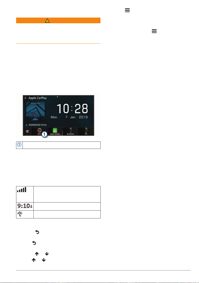
Opens the navigation system when selected.
Status bar icons
The status bar is at the top of the main
menu. The status bar icons display
information about features on the device.
You can select some icons to change
settings or view additional information.
Using the on-screen buttons
• Select to return to the previous menu
screen.
• Hold to quickly return to the main
menu.
• Select or to see more choices.
• Hold or to scroll faster.
system instruction manual.
GPS and GLONASS signal status
NOTE: gLONASS reception is not
available on all device models.
Current time
INRIX Traffic Service status
• Select to see a menu of options for
the current screen.
Removing a shortcut
Select Where To? > > Remove
1
Shortcut(s).
Select a shortcut to remove.
2
Select the shortcut again to confirm.
3
Select Save.
4
Adding a shortcut
You can add shortcuts to the Where To?
menu. A shortcut can point to a location, a
category, or a search tool.
The Where To? menu can contain up to 36
shortcut icons.
Select Where To? > Personalise.
1
Select an item.
2
Using multi-touch controls
You can use multi-touch controls to change
the map view while using the navigation
map.
NOTE: this feature is not available on all
models.
• Pinch two fingers together on the screen
to zoom out.
• Spread two fingers on the screen to
zoom in.
Updating the software
Before you can update the navigation
system software, you must have a USB
mass storage device and an Internet
connection.
Go to http://www.kenwood.com/cs/ce
1
/firmware/.
Enter the model name for your device.
2
Updating map data
You can purchase updated map data from
Garmin®.
Go to www.garmin.com/kenwood.
1
From the Map Updates section, select
2
Update.
Follow the on-screen instructions.
3
Getting started 1
Page 8

Finding locations
About locations
The detailed maps loaded in your device
contain locations, such as restaurants,
hotels and vehicle services. You can use
categories to browse for nearby businesses
and attractions.
Finding a location by category
Select Where To?.
1
Select a category or select Categories.
2
If necessary, select a subcategory.
3
Select a location.
4
Searching within a category
To narrow your search results, you can
search within some categories.
Select Where To?.
1
Select a category or select Categories.
2
If necessary, select a subcategory.
3
If necessary, enter all or part of the name
4
in the search bar.
Calling a location
Before you can use this feature, you must
connect your compatible mobile phone using
Bluetooth® wireless technology.
Select Where To? > Categories.
1
Select a location.
2
Select .
3
Select Call.
4
Finding a location using the search bar
You can use the search bar to search for
locations by entering a category, brand
name, address or town name.
Select Where To?.
1
Select Enter Search in the search bar.
2
Enter all or part of the search term.
3
Suggested search terms appear below
the search bar.
Select an option:
4
• To search for a type of business, enter
a category name (for example,
"cinemas").
• To search for a business name, enter
all or part of the name.
• To search for an address near you,
enter the house number and street
name.
• To search for an address in another
town, enter the house number, street
name, town and county.
• To search for a town, enter the town
and county.
• To search for coordinates, enter
latitude and longitude coordinates.
Select an option:
5
• To search using a suggested search
term, select the term.
• To search using the text you entered,
select .
If necessary, select a location.
6
Changing the search area
From the main menu, select Where To?.
1
Select Searching near:.
2
Select an option.
3
Search tools
Search tools allow you to search for specific
types of locations by responding to onscreen prompts.
Finding an address
NOTE: the order of the steps may change
depending on the map data loaded on your
device.
Select Where To? > Address.
1
If necessary, select County or Country
2
to change the search area.
Select an option:
3
• To narrow your search to a city in the
search area, select Spell Town.
• To narrow your search to a postcode
in the search area, select Enter Post
Code.
• To search for an address in all cities
and postcodes in the search area,
select Search All.
Follow the on-screen instructions to enter
4
address information.
Select the address.
5
2 Finding locations
Page 9

Finding a junction
You can search for a junction between two
streets, motorways, or other roads.
Select Where To? > Categories >
1
Junctions.
Follow the on-screen instructions to enter
2
street information.
Select the junction.
3
Finding a town
Select Where To? > Categories >
1
Towns.
Select an option:
2
• Select a town from the list of nearby
town.
• To search near another location,
select Searching near: (Changing the
search area).
• To search for a town by name, select
Enter Search, enter a town name,
and select .
Finding a location using coordinates
You can find a location using latitude and
longitude coordinates.
Select Where To? > Categories >
1
Coordinates.
If necessary, select > Format, select
2
the correct coordinate format for the type
of map you are using, and select Save.
Select the latitude coordinate.
3
Enter the new coordinate and select
4
Done.
Select the longitude coordinate.
5
Enter the new coordinate and select
6
Done.
Select View on Map.
7
Starting a route by using the map
You can start a route by selecting a location
from the map.
Select View Map.
1
Drag and zoom the map to display the
2
area to search.
If necessary, select to filter the
3
displayed points of interest by category.
Location markers ( or a blue dot)
appear on the map.
Select an option:
4
• Select a location marker.
• Select a point, such as a street,
junction or address location.
Select Go!.
5
Finding a location using quick search
After you have performed a search for a
point of interest, certain categories may
display a Quick Search list that displays the
last four destinations you selected.
Select Where To?.
1
Select a category or select Categories.
2
If applicable, select a destination from the
3
Quick Search list.
If necessary, select the appropriate
4
destination.
Saving a home location
You can set your home location for the
location you return to most often.
Select Where To? > > Set Home
1
Location.
Select Enter My Address, Use Current
2
Location or History.
The location is saved as "Home" in the
History menu.
Going home
Select Where To? > Go Home.
Editing your home location information
Select Where To? > Favourites >
1
Home.
Select .
2
Select > Edit.
3
Enter your changes.
4
Select Done.
5
Finding recently found places
Your device stores the last 50 locations you
have found.
Select Where To? > History.
1
Select a location.
2
Finding locations 3
Page 10

If necessary, select a category.
Clearing the list of recently found places
Select Where To? > History > >
Clear > Yes.
Finding parking
Select Where To? > Categories >
1
Parking.
Select a parking location.
2
Setting a simulated location
If you are indoors or not receiving satellite
signals, you can use the GPS to set a
simulated location.
Select Settings > Navigation > GPS
1
Simulator.
From the main menu, select View Map.
2
Tap the map twice to select an area.
3
The address of the location appears at
the bottom of the screen.
Select the location description.
4
Select Set Location.
5
Saving Locations
Saving a Location
Search for a location (Finding a location
1
by category).
From the search results, select a
2
location.
Select .
3
Select > Save.
4
2
Select a location.
3
Select .
4
Select > Edit.
5
Select an option:
6
• Select Name.
• Select Phone Number.
• Select Categories to assign
categories to the saved location.
• Select Change Map Symbol to
change the symbol used to mark the
saved location on a map.
Edit the information.
7
Select Done.
8
Assigning categories to a saved location
You can add custom categories to organise
your saved locations.
NOTE: categories appear in the saved
locations menu after you have saved more
than 12 locations.
Select Where To? > Favourites.
1
Select a location.
2
Select .
3
Select > Edit > Categories.
4
Enter one or more category names,
5
separated by commas.
If necessary, select a suggested
6
category.
Select Done.
7
Saving your current location
From the map, select the vehicle icon.
1
Select Save.
2
Enter a name and select Done.
3
Select OK.
4
Starting a route to a favourite location
Select Where To? > Favourites.
1
If necessary, select a category or select
2
All Favourites.
Select a location.
3
Select Go!.
4
Editing a favourite location
Select Where To? > Favourites.
1
4 Navigation
Starting a route
Search for a location (About locations).
1
Select a location.
2
Select Go!.
3
If necessary, select a route.
4
Previewing multiple routes
Search for a location (Finding a location
1
by category).
From the search results, select a
2
location.
Select Routes.
3
Navigation
Page 11

Select a route.
4
Select Go!.
5
Your route on the map
NOTICE
The speed limit feature is for information
only and does not replace your responsibility
to abide by all posted speed limit signs and
to use safe driving judgement at all times.
Garmin and JVC KENWOOD will not be
responsible for any traffic fines or citations
you receive for failing to follow all applicable
traffic laws and signs.
The route is marked with a magenta line. A
chequered flag marks your destination.
As you travel, the device guides you to the
destination with voice prompts, arrows on
the map and directions at the top of the
map. If you depart from the original route,
the device recalculates the route and
provides new directions.
Using the Map
From the main menu, select View Map.
1
If the zoom controls are hidden, select
2
the map to display the zoom controls.
Select the map.
3
Select an option:
4
• To zoom in or out, select or .
• To rotate the map view, select .
• To switch between North Up and 3-D
views, select .
• To add or remove map layers, select
.
• To view specific categories, select .
• To centre the map on your current
location, select .
• To view shortcuts for map and
navigation features, select .
Adding a Point to a Route
Before you can add a point, you must be
navigating a route.
From the map, select > Where To?.
1
Search for a location.
2
Select a location.
3
Select Go!.
4
Select Add to Active Route.
5
Navigation 5
Taking a detour
While navigating a route, you can use
detours to avoid obstacles ahead of you,
such as construction zones.
While navigating, select > Detour.
Stopping the route
From the map, select > Stop.
Using suggested routes
Before you can use this feature, you must
save at least one location and enable the
travel history feature (Device and privacy
settings).
Using the myTrends™ feature, your device
predicts your destination based on your
travel history, the day of the week and the
time of day. After you have driven to a
favourite location several times, the location
may appear in the navigation bar on the
map, along with the estimated time of travel
and traffic information.
Select the navigation bar to view a
suggested route to the location.
About exit services
NOTE: you must be on a major motorway or
road to view exit services.
While navigating a route, you can find
businesses and services near upcoming
exits. Services are listed by category.
Fuel
Food
Accommodation
Toilets
Finding exit services
From the map, select > Exit Services.
1
Use the arrows to select an upcoming
2
exit.
Select an exit service tab.
3
Select a point of interest.
4
Navigating to an exit
From the map, select > Exit Services
1
> .
Select Go!.
2
Page 12

Avoiding road features
Select Settings > Navigation >
1
Avoidances.
Select the road features to avoid on your
2
routes and select Save.
NOTE: when motorway avoidances are
enabled, long-distance routes may still
include motorways.
About custom avoidances
Custom avoidances allow you to avoid
specific areas and sections of road. You can
enable and disable custom avoidances as
needed.
Avoiding an area
Select Settings > Navigation > Custom
1
Avoidances.
If necessary, select Add Avoidance.
2
Select Add Avoid Area.
3
Select the upper left corner of the area to
4
avoid and select Next.
Select the lower right corner of the area
5
to avoid and select Next.
The selected area is shaded on the map.
Select Done.
6
Avoiding a road
Select Settings > Navigation > Custom
1
Avoidances.
Select Add Avoid Road.
2
Select the starting point of the section of
3
road to avoid and select Next.
Select the ending point of the road
4
section and select Next.
Select Done.
5
Disabling a custom avoidance
You can disable a custom avoidance without
deleting it.
Select Settings > Navigation > Custom
1
Avoidances.
Select a created avoidance.
2
Select > Disable.
3
Deleting custom avoidances
Select Settings > Navigation > Custom
1
Avoidances.
Select an option:
2
• To delete all custom avoidances,
select .
• To delete one custom avoidance,
select the avoidance and select >
Delete.
Enabling advanced detours
Select Settings > Navigation >
Advanced Detours.
Taking a detour
Before you can take a detour, you must be
navigating a route.
You can take a detour for a specified
distance along your route or detour around
specific roads. This is useful if you
encounter construction zones, closed roads
or poor road conditions.
From the map, select > Detour.
1
Select an option.
2
• To detour your route for a specific
distance, select a distance.
• To detour around a specific road on
the route, select Detour by Road(s)
on Route, and select a road around
which to detour.
Custom points of interest
Custom POIs are customised points on the
map. They can contain alerts that let you
know if you are near a designated point or if
you are travelling faster than a specified
speed.
Installing POI Loader software
You can create or download custom POI
lists on your computer and install them on
your device using POI Loader software. You
must use a USB mass storage device to
load POIs.
Go to www.garmin.com/extras.
1
Click Services & Utilities > POI Loader.
2
Install the POI Loader onto your
3
computer.
Installing custom points of interest
Before you can install custom points of
interest, you must prepare POI lists for
installation using the POI Loader application.
Connect a USB mass storage device to
1
your computer.
6 Navigation
Page 13

On the USB mass storage device, create
2
a new folder named Garmin.
Copy the custom POI files to the Garmin
3
folder on the USB mass storage device.
Connect the USB mass storage device to
4
your KENWOOD system.
On the KENWOOD system screen, select
5
Yes.
Select Custom POIs.
6
Select Install.
7
The KENWOOD system imports the custom
points of interest into the system storage.
Using the POI Loader Help Files
For more information on the POI loader,
refer to the Help file.
With the POI loader open, click Help.
Find Extras
Select Where To? > Categories >
1
Custom POIs.
Select a category.
2
Map pages
Customising the map
Customising the map layers
You can customise which data appears on
the map, such as icons for points of interest
and road conditions.
From the map, select .
1
Select Map Layers.
2
Select which layers you want to include
3
on the map and select Save.
Viewing the trip log
Your device keeps a trip log, which is a
record of the path you have travelled.
Select Settings > Map & Vehicle > Map
1
Layers.
Select the Trip Log tick box.
2
Select Save.
3
Changing the map data field
From the map, select the data field in the
1
lower left-hand corner.
Select a type of data to display.
2
Select Save.
3
Customising map buttons
You can include up to three icons on the
right side of the main map.
Select Settings > Map & Vehicle > Map
1
Buttons.
Select an icon and select OK.
2
Select .
3
Select a different icon.
4
Select Save.
5
Removing buttons from the map
You can remove all buttons from the right
side of the map.
Select Settings > Map & Vehicle > Map
1
Buttons.
Select an icon and select OK.
2
Select Save.
3
Changing the map perspective
Select Settings > Map & Vehicle >
1
Driving Map View.
Select an option:
2
• Select Track Up to display the map in
two dimensions (2-D), with your
direction of travel at the top.
• Select North Up to display the map in
2-D with north at the top.
• Select 3-D to display the map in three
dimensions.
Select Save.
3
Viewing Route Activity
Viewing a route summary
While navigating a route, you can view all of
the turns and manoeuvres for your entire
route and the distance between turns.
While navigating a route, select the text
1
bar on the top of the map.
Select a turn.
2
The details for the turn appear. If
available, an image of the junction
appears for junctions on major roadways.
Viewing the entire route on the map
While navigating a route, select the
1
navigation bar at the top of the map.
Select > Map.
2
Map pages 7
Page 14

Viewing the next turn
While navigating a route, a preview of the
next turn, lane change or other manoeuvre
appears in the upper left corner of the map.
The preview includes the distance to the
turn or manoeuvre and the lane in which you
should be travelling, if available.
From the map, select to view the
next turn on the map.
Viewing traffic alerts
While navigating a route, a traffic alert may
appear in the navigation bar.
Select the alert to view more information.
Viewing junctions
While navigating a route, you can view the
junctions on major roadways. When you
approach a junction in a route, the image of
that junction appears briefly, if available.
NOTE: this feature is not available on all
models.
From the map, select to view the
junction, if available.
Viewing the trip information page
The trip information page displays your
speed and provides statistics about your trip.
NOTE: if you make frequent stops, leave the
device turned on, so it can accurately
measure elapsed time during the trip.
From the map, select Speed.
Resetting trip information
From the map, select Speed.
1
Select > Reset All.
2
Select an option:
3
• When not navigating a route, select
Select All to reset every data field on
the first page except the speedometer.
• Select Reset Trip Data to reset the
information on the trip computer.
• Select Reset Trip B to reset the
odometer.
• Select Reset Max. Speed to reset the
maximum speed.
Select Reset.
4
Getting directions to your current location
If you need to tell another person how to get
to your current location, your device can
give you a list of directions.
From the map, select the vehicle.
1
Select > Directions to Me.
2
Viewing current location information
You can use the Where Am I? page to view
information about your current location. This
feature is helpful if you need to tell
emergency personnel your location.
From the map, select > Where Am I?.
Finding nearby services
You can use the Where Am I? page to find
nearby services, such as hospitals or police
stations.
From the map, select > Where Am I?.
1
Select a category.
2
Using the apps
Searching help topics
Select Apps > Help > .
About ecoRoute
The ecoRoute™ feature calculates the fuel
economy and the fuel price of navigating to
a destination, and offers tools for improving
fuel efficiency.
The data provided by the ecoRoute feature
is an estimate only.
To receive more accurate fuel reports for
your specific vehicle and driving habits,
calibrate the fuel economy (Calibrating the
fuel economy).
Setting Up the Vehicle
The first time you use the ecoRoute
features, you must enter vehicle information.
Select Apps > ecoRoute™.
1
Follow the on-screen instructions.
2
Calibrating the fuel economy
You can calibrate the fuel economy to
receive more accurate fuel reports for your
8 Using the apps
Page 15

specific vehicle and driving habits. You
should calibrate when you fill up your fuel
tank.
Select Apps > ecoRoute™ > At the
1
Pump.
Enter the current fuel price.
2
Enter the amount of fuel the vehicle has
3
used since the last time the fuel tank was
filled.
Enter the distance you have travelled
4
since the last time the fuel tank was filled.
Select Next.
5
The device calculates the average
vehicle fuel economy.
Select Save.
6
Changing the fuel price
Select Apps > ecoRoute™ > At the
1
Pump.
Enter the current price of fuel, and select
2
Next.
Select Yes.
3
About ecoChallenge
ecoChallenge helps you maximise the
vehicle fuel economy by scoring your driving
habits. The higher your ecoChallenge
scores, the more fuel you save.
ecoChallenge collects data and calculates a
score whenever your vehicle is moving.
Viewing ecoChallenge scores
Select Apps > ecoRoute™ >
ecoChallenge.
About the ecoChallenge score
The leaf colour on the ecoChallenge icon
changes depending on your performance in
the challenge.
Total: displays an average of the speed,
acceleration and braking score.
Speed: displays your score for driving your
vehicle at the optimal speed for
conserving fuel.
Acceleration: displays your score for
smooth and gradual acceleration. You
lose points for rapid acceleration.
Braking: displays your score for smooth and
gradual braking. You lose points for hard
braking.
Resetting the ecoChallenge scores
Select Apps > ecoRoute™ >
1
ecoChallenge.
Select > Reset.
2
Select Yes.
3
Viewing fuel economy information
Select Apps > ecoRoute™ > Fuel
1
Economy.
Select a section of the graph to zoom in.
2
Mileage reports
Mileage reports provide the distance, the
time, the average fuel economy and the fuel
cost of navigating to a destination.
A mileage report is created for every route
that you drive. If you stop a route on your
device, a mileage report is created for the
distance you travelled.
Exporting a mileage report
Connect a USB mass storage device to
1
your KENWOOD unit.
Select Apps > ecoRoute™ > Mileage
2
Report.
Select Export to export and save a report
3
to the USB mass storage device.
Resetting ecoRoute™ Information
Select Apps > ecoRoute™ > Vehicle
1
Profile.
Select Reset.
2
Select Yes.
3
Planning a trip
You can use the trip planner to create and
save a trip with multiple destinations.
Select Apps > Trip Planner.
1
Select New Trip.
2
Select Select Start Location.
3
Search for a location (Finding a location
4
by category).
Select Select.
5
To add additional locations, select .
6
Search for a location.
7
Select Select.
8
Select Next.
9
Enter a name and select Done.
10
Using the apps 9
Page 16

Scheduling a trip
You can add scheduling information to each
location in your trip, including the desired
arrival time and layover duration at each
location. This can help you plan your
departure to reach locations in your trip on
time.
Select Apps > Trip Planner.
1
Select a trip.
2
Select a location.
3
Select Departure Time or Arrival Time.
4
Select a date and time, and select Save.
5
Select Duration.
6
Select the amount of time you intend to
7
spend at the location, and select Save.
If necessary, repeat steps 3 to 7 for each
8
location.
Navigating to a saved trip
Select Apps > Trip Planner.
1
Select a saved trip.
2
Select Go!.
3
Select your next destination.
4
If prompted, select a route.
5
Editing a saved trip
Select Apps > Trip Planner.
1
Select a saved trip.
2
Select .
3
Select an option:
4
• Select Edit Destinations to add and
delete a location, or to change the
order of locations.
• Select Delete Trip.
• Select Rename Trip.
• Select Optimise Order to arrange the
stops on your trip in the most-efficient
order.
• Select Route Preference to change
the route calculation mode for your
trip.
Saving trip logs
Trip logs are recorded while you navigate a
route.
NOTE: trip log data is saved as a .gpx file.
Connect a USB mass storage device to
1
your KENWOOD unit.
Select Apps > My Data > Manage Trip
2
Log.
Select a trip log segment or select View
3
All Segments.
Select Share to export to the USB mass
4
storage device.
Viewing previous routes and destinations
Before you can use this feature, you must
enable the travel history feature (Device and
privacy settings).
You can view your previous routes and
places you have stopped on the map.
Select Apps > Where I've Been.
Viewing the weather forecast
Before you can use this feature, your device
must be connected using Bluetooth to
access connected services. This feature is
not available in all areas.
Select Apps > Weather.
1
Select a day.
2
The detailed forecast for that day
appears.
Viewing weather near a different town
Select Apps > Weather > Current
1
Location.
Select an option:
2
• To view weather for a favourite town,
select a town in the list.
• To add a favourite town, select Add
Town, and enter a town name.
Viewing Road Weather
Before you can use this feature, your device
must be connected using Bluetooth wireless
technology to access connected services.
This feature is not available in all areas.
Select Apps > Road Weather.
1
Weather events that affect road
conditions appear on the map.
Select a weather event to view details
2
about the event.
10 Using the apps
Page 17

Finding petrol stations and prices
Before you can use this feature, your device
must be connected using Bluetooth to
access connected services.
You can find nearby petrol stations and
compare fuel prices.
Select Apps > Fuel Prices.
1
If necessary, select > Fuel Type,
2
select a fuel type, and select Save.
Select a petrol station.
3
Traffic data using INRIX Traffic Service
You can purchase a traffic subscription to
receive traffic data using INRIX traffic
service. When your navigation system is
connected to INRIX and within a traffic
coverage area, your system begins
displaying traffic information. Traffic data is
not available in all areas or regions.
See the KENWOOD Traffic Powered By
INRIX™ application for INRIX traffic
subscription information.
Dynamic Parking
Before you can use this feature, your device
must be connected using Bluetooth to
access connected services. This feature is
not available in all areas.
You can find detailed parking information,
including parking availability in nearby
garages and pricing information.
Select Apps > Dynamic Parking.
1
Select a parking location.
2
About traffic
NOTICE
Garmin and JVC KENWOOD are not
responsible for the accuracy or timeliness of
traffic information.
Your navigation system can receive traffic
information using the built-in traffic receiver
or a subscription to INRIX® Traffic Service.
The traffic receiver must be in data range of
a station transmitting traffic data to receive
traffic information. The traffic subscription
activates automatically after your navigation
system acquires satellite signals while
receiving traffic signals from the service
provider. When receiving INRIX traffic
information, FM TMC information is not
displayed. You can add other subscriptions
at any time. For information about traffic
receivers and coverage areas, go to
www.garmin.com/kenwood.
NOTE: INRIX Traffic Service and FM TMC
Traffic are not available on all models or in
all areas.
FM TMC traffic
FM Traffic Message Channel (TMC) traffic
receivers receive traffic information
broadcast over the FM Radio Data System.
The FM TMC subscription activates
automatically after your navigation system
acquires satellite signals while receiving
traffic signals from the service provider. You
can add other FM TMC subscriptions at any
time.
NOTE: the availability of FM TMC depends
on your region and may require the
purchase of a subscription.
For information about traffic receivers and
coverage areas, go to www.garmin.com
/kenwood.
About the traffic icon
When you are receiving traffic information, a
traffic icon appears on the map. The traffic
icon changes colour to indicate the severity
of traffic conditions.
Green: traffic is flowing freely.
Yellow: traffic is moving, but there is a
delay. There is moderate traffic
congestion.
Red: traffic is not moving or moving very
slowly. There is a severe delay.
Grey: traffic information is not available.
Traffic on your route
Viewing traffic on your route
While navigating a route, select .
1
Select Traffic On Route.
2
A list of traffic events appears, organised
by their location on the route.
About traffic 11
Page 18

Select an event.
3
Manually avoiding traffic on your route
From the map, select .
1
Select Traffic On Route.
2
If necessary, use the arrows to view other
3
traffic delays on your route.
Select > Avoid.
4
Taking an alternative route
While navigating a car route, select .
1
Select Alternative Route.
2
Select a route.
3
Viewing traffic on the map
The Traffic map shows colour-coded traffic
flow and delays on nearby roads.
From the map, select .
1
Select Traffic Conditions.
2
Traffic in your area
Searching for traffic delays
From the map page, select .
1
Select Traffic Conditions > .
2
Select an item in the list.
3
If there is more than one delay, use the
4
arrows to view additional delays.
Viewing a traffic incident on the map
From the map, select .
1
Select Traffic Conditions.
2
Select a traffic icon.
3
Vehicle: sets the icon that represents your
position on the map.
Driving Map View: sets the perspective on
the map.
Map Detail: sets the level of detail on the
map. More detail may cause the map to
draw slower.
Map Theme: changes the colour of the map
data.
Map Buttons: sets which icons are included
on the map. Up to three icons can be
included on the map.
Map Layers: sets the data that appears on
the map page (Customising the map
layers).
Dashboards: sets the map dashboard
layout.
Auto Zoom: automatically selects the zoom
level for optimal use of your map. When
disabled, you must zoom in or out
manually.
Audible Speed Alerts: alerts you when
your vehicle is exceeding the speed limit.
NOTE: this feature is not available in all
areas.
myMaps: sets which installed maps the
device uses.
Enabling maps
You can enable map products installed on
your device.
Select Settings > Map & Vehicle >
1
myMaps.
Select a map.
2
Understanding traffic data
The traffic legend explains the icons and
colours used on the traffic map.
From the map, select > Traffic.
1
Select Traffic Legend.
2
Customising the device
Map and vehicle settings
To open the Map and Vehicle settings, from
the main menu, select Settings > Map &
Vehicle.
12 Customising the device
Navigation settings
To open the Navigation settings page, from
the main menu, select Settings >
Navigation.
Calculation Mode: sets the route
calculation method.
Avoidances: sets road features to avoid on
a route.
Custom Avoidances: allows you to avoid
specific roads or areas.
Advanced Detours: sets the length of a
detour.
Page 19

Safe Mode: disables all functions that
require significant operator attention and
could become a distraction while driving.
Voice Prompts: enables voice prompts.
GPS Simulator: stops the device from
receiving GPS and GLONASS signals.
Changing the route calculation mode
Select Settings > Navigation >
1
Calculation Mode.
Select an option:
2
• Select Faster Time to calculate routes
that are faster to drive but can be
longer in distance.
• Select Shorter Distance to calculate
routes that are shorter in distance but
can take more time to drive.
• Select Less Fuel to calculate routes
that are more fuel-efficient.
Select Save.
3
Display Settings
Select Settings > Display.
Colour Mode: allows the device to display
day or night colours.
trafficTrends
When the trafficTrends feature is enabled,
your device uses historic traffic data to
calculate more-efficient routes.
NOTE: different routes may be calculated
based on traffic trends for the day of the
week or the time of day.
Disabling trafficTrends
To prevent your device from recording traffic
data, you must disable trafficTrends.
Select Settings > Traffic >
trafficTrends™.
Units and time settings
To open the Units and Time settings page,
from the main menu, select Settings >
Units & Time.
Current Time: sets the device time.
Time Format: allows you to select a 12-
hour, 24-hour or UTC display time.
Units: sets the unit of measure used for
distances.
Language and Keyboard Settings
Changing the Colour Mode
Select Settings > Display > Colour
1
Mode.
Select an option:
2
• To use a light background, select Day.
• To use a dark background, select
Night.
• To allow the device to display day or
night colours automatically, based on
the time of day, select Auto.
Traffic Settings
From the main menu, select Settings >
Traffic.
Traffic: enables traffic.
Subscriptions: lists the current traffic
subscriptions.
trafficTrends™: enables the trafficTrends
feature (trafficTrends).
Traffic Voice Prompts: enables voice
prompts for traffic events.
Customising the device 13
To open the Language and Keyboard
settings, from the main menu, select
Settings > Language & Keyboard.
NOTE: to change the text language settings,
see the KENWOOD system instruction
manual.
Voice Language: sets the language for
voice prompts.
Keyboard Language: sets the language for
your keyboard.
Keyboard Layout: sets the keyboard
layout.
Device and privacy settings
To open the Device settings page, from the
main menu, select Settings > Device.
About: displays the software version
™
number, the unit ID number and
information on several other software
features.
Travel History: allows the device to record
information for the myTrends (Using
suggested routes), Where I've Been
(Viewing previous routes and
Page 20

destinations) and Trip Log (Viewing the
trip log) features.
Clear Travel History: clears your travel
history from the navigation system.
Update Map: exports data from the
navigation unit for updates (Updating
map data).
Proximity alerts settings
NOTE: you must have custom points of
interest (POIs) loaded for proximity points
alerts to display.
NOTE: this feature is not available in all
areas.
Select Settings > Proximity Alerts.
Audio: sets the style of alert that plays when
you approach proximity points.
Alerts: sets the type of proximity points for
which alerts are played.
Restoring settings
You can restore a category of settings or all
settings to the factory default values.
Select Settings.
1
If necessary, select a settings category.
2
Select > Restore.
3
Select Yes.
4
14 Customising the device
Page 21

Page 22

To download free navigation software updates and purchase updated maps for
your product, go to www.garmin.com/kenwood.
190-02509-00_0B
 Loading...