

Page 1

GTS 8XX Series
Pilot’s Guide
Traffic Advisory System
Page 2

© 2009 Garmin Ltd. or its subsidiaries. All rights reserved.
Garmin International, Inc., 1200 East 151st Street, Olathe, KS 66062, U.S.A.
Tel: 913/397.8200 Fax: 913/397.8282
Garmin AT, Inc., 2345 Turner Road SE, Salem, OR 97302, U.S.A.
Tel: 503/391.3411 Fax 503/364.2138
Garmin (Europe) Ltd., Liberty House, Bulls Copse Road, Hounsdown Business Park, Southampton,
SO40 9RB, U.K.
Tel. +44 (0) 870 850 1243 Fax +44 (0) 238 052 4004
Garmin Corporation, No. 68, Jangshu 2nd Road, Shijr, Taipei County, Taiwan
Tel: 886/02.2642.9199 Fax: 886/02.2642.9099
At Garmin, we value your opinion. For comments about this guide, please e-mail:
Techpubs.Salem@Garmin.com
www.garmin.com
Except as expressly provided herein, no part of this manual may be reproduced, copied, transmitted,
disseminated, downloaded or stored in any storage medium, for any purpose without the express written
permission of Garmin. Garmin hereby grants permission to download a single copy of this manual and of
any revision to this manual onto a hard drive or other electronic storage medium to be viewed for personal
use, provided that such electronic or printed copy of this manual or revision must contain the complete text
of this copyright notice and provided further that any unauthorized commercial distribution of this manual
or any revision hereto is strictly prohibited.
December 2009 Printed in the U.S.A.
Page 3

LIMITED WARRANTY
This Garmin product is warranted to be free from defects in materials or workmanship for two years from
the date of purchase. Within this period, Garmin will, at its sole option, repair or replace any components
that fail in normal use. Such repairs or replacement will be made at no charge to the customer for parts
and labor, provided that the customer shall be responsible for any transportation cost. This warranty does
not cover failures due to abuse, misuse, accident, or unauthorized alterations or repairs.
THE WARRANTIES AND REMEDIES CONTAINED HEREIN ARE EXCLUSIVE AND IN LIEU OF ALL OTHER
WARRANTIES EXPRESS OR IMPLIED OR STATUTORY, INCLUDING ANY LIABILITY ARISING UNDER
ANY WARRANTY OF MERCHANTABILITY OR FITNESS FOR A PARTICULAR PURPOSE, STATUTORY OR
OTHERWISE. THIS WARRANTY GIVES YOU SPECIFIC LEGAL RIGHTS, WHICH MAY VARY FROM STATE TO
STATE.
IN NO EVENT SHALL GARMIN BE LIABLE FOR ANY INCIDENTAL, SPECIAL, INDIRECT OR CONSEQUENTIAL
DAMAGES, WHETHER RESULTING FROM THE USE, MISUSE, OR INABILITY TO USE THIS PRODUCT OR
FROM DEFECTS IN THE PRODUCT. Some states do not allow the exclusion of incidental or consequential
damages, so the above limitations may not apply to you.
Garmin retains the exclusive right to repair or replace the unit or software, or to offer a full refund of the
purchase price, at its sole discretion. SUCH REMEDY SHALL BE YOUR SOLE AND EXCLUSIVE REMEDY FOR
ANY BREACH OF WARRANTY.
To obtain warranty service, contact your local Garmin Authorized Service Center. For assistance in
locating a Service Center near you, visit the Garmin web site at http://www.garmin.com or contact
Garmin Customer Service at 800-800-1020.
Garmin GTS 8XX Series Traffic Advisory System
i190-00587-02 Rev. A
Page 4

WARNINGS, CAUTIONS, AND NOTES
WARNING: The GTS 8XX Series Traffic Advisory System (TAS and TCAS I)
is intended for advisory use only to aid the pilot in visually acquiring
traffic. No avoidance maneuvers should be based solely upon TAS traffic
information. It is the responsibility of the pilot in command to see and
maneuver to avoid traffic.
NOTE: Pilots should be aware of TAS/TCAS system limitations. TAS/TCAS
systems require intruder transponders to respond to system interrogations.
If an intruder transponder does not respond to interrogations due to
antenna shading or marginal transponder performance, it will not be
displayed, or display may be intermittent. Pilots should remain vigilant
for traffic at all times when using TAS/TCAS systems for non-transponder
equipped airplanes or unresponsive airplanes.
TSO COMPLIANCE
GTS Unit Product Description Applicable TSO
GTS 800 Low Power TAS C147, C166a
GTS 820 High Power TAS C147, C166a
GTS 850 TCAS I C118, C166a
Table 1 GTS 8XX Series Family TSO Compliance
ii
Garmin GTS 8XX Series Traffic Advisory System
190-00587-02 Rev. A
Page 5

Contents
LIMITED WARRANTY ........................................................................................i
Warnings, Cautions, and Notes .......................................................................ii
TSO Compliance..............................................................................................ii
Product Description ........................................................................................2
Compatible Display Units .................................................................................. 4
GTS 800........................................................................................................... 5
GTS 820........................................................................................................... 5
GTS 850........................................................................................................... 5
Antennas ......................................................................................................... 5
General Antenna Information .................................................................... 5
GTS 8XX Series Antenna Configurations .................................................... 6
GA 58 Directional Antenna ........................................................................ 6
Bottom Mounted Directional Antenna (optional) ........................................ 6
Bottom Mounted Monopole Antenna (optional) ......................................... 7
GPA 65 PA / LNA Module (GTS 820 & 850 only) ............................................... 7
Operation .......................................................................................................8
GTS 8XX Series Traffic ....................................................................................... 8
Theory of Operation .......................................................................................... 8
TAS/TCAS Surveillance Volume .................................................................. 8
TAS/TCAS Symbology ................................................................................ 9
GTS 8XX Series Sensitivity Level ............................................................... 11
Traffic Advisory (TA) Alerting Conditions ................................................... 12
TAS/TCAS Alerts ...................................................................................... 13
System Test ............................................................................................. 14
Power-Up .............................................................................................. 15
System Status ......................................................................................... 15
Q and A .........................................................................................................17
Glossary ........................................................................................................19
Index .............................................................................................................20
Garmin GTS 8XX Series Traffic Advisory System
1190-00587-02 Rev. A
Page 6
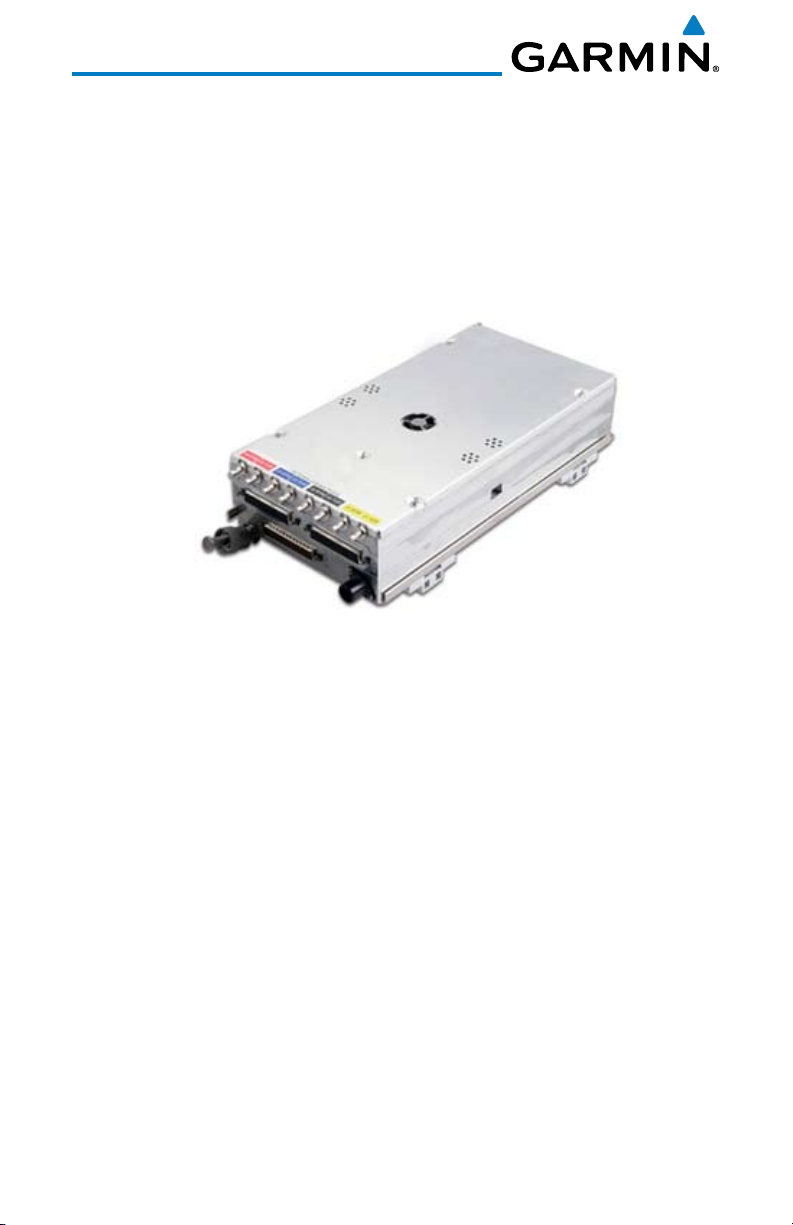
PRODUCT DESCRIPTION
The GTS 8XX Series Traffic Advisory System (TAS) and Traffic Collision
Avoidance System (TCAS I) uses active interrogations of Mode A/C/S transponders
to provide Traffic Advisories to the pilot independent of the air traffic control
system. The system also uses passive surveillance by means of an Automatic
Dependent Surveillance – Broadcast (ADS-B) receiver which is enabled when
installed with an ADS-B link transmit class of equipment.
Figure 1 GTS 8XX LRU
The GTS 8XX Series of Traffic Advisory System (TAS) or Traffic Alert and
Collision Avoidance System (TCAS I) microprocessor-based sub-systems products
consist of the GTS 800, GTS 820 and GTS 850. The GTS 800 TAS product consists
of one LRU which has low power (40 Watts) transmit capability, and one GA 58,
or other Garmin-approved, directional antenna. The GTS 820 TAS and GTS 850
TCAS I products include one LRU paired with one GPA 65 PA/LNA Amplifier
Module, which allows high power (250W) transmit capability, and one GA 58 or
other Garmin-approved directional antenna. An optional second antenna may also
be installed with these systems. The optional second bottom mounted antenna
may be omnidirectional or a Garmin approved directional antenna.
For targets equipped with a 1090 MHz ADS-B transmit class of equipment, the
GTS 8XX series combines active (interrogated) and passive (ADS-B) surveillance
data to enhance the accuracy of target position on the display. The systems use
Garmin’s CLEAR CASTM technology to correlate ADS-B and actively interrogated
targets to provide pilots with the most accurate target position. Passive ADS-B
surveillance is enabled when the GTS 8XX is installed with an ADS-B transmit
class of equipment.
2
Garmin GTS 8XX Series Traffic Advisory System
190-00587-02 Rev. A
Page 7
The GTS 8XX Series provides for expanded audio messaging in an ATC-like
verbal format: “Traffic. One o’clock. High (or Low or Same Altitude). Two miles.”
If surveillance bearing information is not available on the intruder, “Traffic, No
Bearing” is called out.
Bearing may be derived from either the top or bottom directional antenna
depending upon which antenna hears the response. A directional antenna is used
to derive bearing to the intruder aircraft, which is displayed with relative altitude
to own aircraft. Top antenna transmitted interrogations are directional, reducing
the number of transponders that receive the interrogation thus reducing potential
garble on the 1090 MHz band.
Note: GTS 8XX is used throughout this manual to refer to the GTS 800,
820, or 850 products. When a feature is unique to the GTS 800, 820, or
850 it will be specifically referenced as such.
Product GTS 800 GTS 820 GTS 850
Traffic Advisory System (TAS) X X
Traffic Alert and Collision Avoidance System
X
(TCAS I)
LRU X X X
GPA 65 PA/LNA X X
1090 ES ADS-B Receiver X X X
Transmit Power (Watts) 40 250 250
Top-Mounted Garmin-Approved Directional
X X X
Antenna
Optional Bottom-Mounted Garmin-Approved
X X X
Directional or Omnidirectional Antenna
Table 2 GTS 8XX Series Family Product Description
The GTS 8XX Series does not contain a display, but transmits traffic data to a
Garmin or third party multi-function display that is capable of displaying traffic
data. More information is located in the installation manual. The GTS 8XX Series
supplies data to a traffic display to indicate the presence and location of intruder
aircraft. The information provides the crew with the intruder’s range, bearing,
and, for altitude reporting intruders, relative altitude and vertical trend. TCAS I
symbology as defined in the FAA Advisory Circular entitled “Airworthiness
Garmin GTS 8XX Series Traffic Advisory System
3190-00587-02 Rev. A
Page 8

Approval of Traffic and Collision Avoidance Systems (Active TCAS I)” is utilized
to depict traffic information.
Compatible Display Units
The following table lists compatible display units. As products may
continually be added to the list of compatible display units, always refer to the
GTS 8XX Installation Manual for a complete list. Some displays may require
the purchase and installation of additional modules and/or software to support
traffic displays. Check with your installer to ensure an existing display supports
traffic prior to installation.
Manufacturer Model
Garmin GMX 200/MX20
Garmin GNS 400/500 Series
Garmin GNS 400W/500W Series
Garmin GNS 480
Garmin GDU 620
Avidyne EX500 (MFD Only)
Honeywell Bendix/King KMD 550/850
Sandel SN3500/SN4500
Table 3 GTS 8XX Series Compatible Display Units
4
Garmin GTS 8XX Series Traffic Advisory System
190-00587-02 Rev. A
Page 9

GTS 800
The GTS 800 is a TAS system that can track up to 45 Mode A/C/S targets,
and display up to 30 intruder threats at a time, depending on the display being
utilized. Offering 40 watts of transmit power, a ±10,000 foot vertical separation
maximum, and an active interrogation range of up to 12 NM in the forward
direction, the GTS 800 system will interface with a variety of compatible system
displays in the cockpit.
GTS 820
The GTS 820 is a TAS system that can track up to 45 intruding aircraft
equipped with Mode A/C transponders, and up to 30 intruders equipped with
Mode S transponders. A GTS 820 TAS has an active surveillance range of up to
40 NM in the forward direction, dependent upon interference limiting techniques
based on the number of TCAS II interrogators in the area. Interrogation power
and range in the left, right, and aft quadrants is reduced in a manner similar to
TCAS II systems. It includes a GPA 65 PA/LNA Module that is remotely installed
near the top directional antenna to boost the interrogation range.
GTS 850
The GTS 850 is a fully compliant TCAS I certified system. Operational
capabilities are similar for airborne traffic surveillance for both the GTS 820 and
GTS 850 systems.
Antennas
General Antenna Information
A top-mounted directional antenna is used to derive bearing to the intruder
aircraft. Top antenna transmitted interrogations are directional, reducing the
number of transponders that receive the interrogation thus reducing potential
garble on the 1090 MHz band.
Optional bottom monopole or directional antenna transmit interrogations are
omnidirectional. Intruder bearing can be determined from the top directional
antenna or an optional bottom directional antenna for retractable gear aircraft.
Garmin GTS 8XX Series Traffic Advisory System
5190-00587-02 Rev. A
Page 10

GTS 8XX Series Antenna Configurations
• Toponlydirectionalantenna.
• Top directionalwithbottom monopoleantennas(recommended forxed
gear aircraft) provides improved intruder visibility. The type of antenna used
will be primarily limited by the amount of space available on the bottom
of the airplane. Any aircraft that can utilize the directional antenna on the
bottom would benefit from its use.
• Top directional with bottom directional antennas (recommended for
retractable gear aircraft) provides benefit of intruder bearing visibility for
targets that are shaded from the top directional antenna.
GA 58 Directional Antenna
The GA 58 directional four element antenna is included with the basic GTS
system to provide altitude, distance, and bearing of threat aircraft. A single antenna
installation uses top-mounted placement. A second GA 58 may be bottommounted to optimize coverage.
Figure 2 GA 58 Directional Antenna
Bottom Mounted Directional Antenna (optional)
A directional antenna may be used as an additional antenna for bottommounting to reduce shading and provide altitude and distance of threat aircraft.
Interrogations from the bottom directional antenna are transmitted in an
omnidirectional pattern, but it still allows bearing determination from replies
received on the bottom antenna.
6
Garmin GTS 8XX Series Traffic Advisory System
190-00587-02 Rev. A
Page 11

Bottom Mounted Monopole Antenna (optional)
The addition of an optional bottom-mounted monopole antenna will improve
visibility of intruder aircraft by reducing shading and providing altitude and
distance of threat aircraft. Bearing cannot be determined from replies received
on a bottom-mounted monopole antenna.
Figure 3 Bottom-Mounted Monopole Antenna
GPA 65 PA / LNA Module (GTS 820 & 850 only)
The GPA 65 is a combined Power Amplifier and Low Noise Amplifier module
used in the higher power GTS 820 and 850.
Figure 4 GPA 65 PA/LNA Module
Garmin GTS 8XX Series Traffic Advisory System
7190-00587-02 Rev. A
Page 12

OPERATION
GTS 8XX Series Traffic
The Garmin GTS 8XX Series unit is a Traffic Advisory System (TAS - GTS 800
and GTS 820) or Traffic Alert and Collision Avoidance System (TCAS I - GTS 850).
The GTS 8XX Series enhances flight crew situational awareness by displaying traffic
information for transponder-equipped aircraft. The GTS 8XX Series also provides
visual and aural traffic alerts including voice announcements to assist in visually
acquiring traffic. The GTS 800 and GTS 820 are TAS systems, the GTS 850 is a
TSO-approved TCAS I system. The GTS 8XX uses active interrogations of Mode
A/C/S transponders to provide Traffic Advisories.
Theory of Operation
When the GTS 8XX Series is in Operating Mode, the unit interrogates the
transponders of intruding aircraft while monitoring transponder replies. The
GTS 8XX Series uses this information to derive the distance, relative bearing, and
if reported, the altitude and vertical trend for each aircraft within its surveillance
range. The GTS 8XX Series then calculates a closure rate to each intruder based
on the projected Closest Point of Approach (CPA). If the closure rate meets the
threat criteria for a Traffic Advisory (TA), visual and aural alerting is provided.
TAS/TCAS Surveillance Volume
The GTS 8XX Series surveillance system monitors the airspace within ±10,000
feet of own altitude. Under ideal conditions, the unit scans transponder traffic
up to 40 NM (GTS 820 and GTS 850) or 12 NM (GTS 800) in the forward
direction using top and bottom-mounted antennas similar to TCAS II systems.
In areas of greater transponder traffic density or when TCAS II systems are
detected, the GTS 820 and GTS 850 systems automatically reduce interrogation
transmitter power (and therefore range) in order to limit potential interference
from frequency congestion. The GTS 800’s range is 12 NM in the forward direction
and the maximum interrogation transmitter power remains constant. There is
also a minimum alerting threshold for range to allow alerting in situations where
traffic is slowly converging. Alerting may be caused by closure rate or minimum
distance to the intruder.
8
Garmin GTS 8XX Series Traffic Advisory System
190-00587-02 Rev. A
Page 13

TAS/TCAS Symbology
The GTS 8XX Series supports displays that depict intruding traffic using the
symbols shown in the following table. Refer to the documentation for the specific
display to confirm the supported symbology. Symbol colors may vary depending
on the display product.
TAS Symbol Description
Non-Threat Traffic
(intruder is beyond 6 NM and greater than 1200 feet vertical
separation)
Proximity Advisory (PA)
(intruder is within 6 NM and less than 1200 feet vertical separation)
Traffic Advisory (TA)
(closing rate, distance, and vertical separation meet TA criteria)
Traffic Advisory Off Scale
Table 4 TAS Intruder Symbol Description
A Traffic Advisory (TA), displayed as a yellow circle, alerts the crew to a
potentially hazardous intruding aircraft if the closing rate, distance, and vertical
separation meet TA criteria. A Traffic Advisory that is beyond the selected display
range is indicated by a half TA symbol at the edge of the screen at the relative
bearing of the intruder.
A Proximity Advisory (PA), displayed as a solid white diamond, indicates the
intruding aircraft is within ±1200 feet and is within a 6 NM range, but is still not
considered a TA threat.
A non-threat symbol, shown as an open white diamond, is displayed for all
other traffic beyond 6 NM that does not meet the criteria to be a TA or PA.
Relative altitude, when available, is displayed above or below the corresponding
intruder symbol in hundreds of feet. When this altitude is above own aircraft,
it is preceded by a “+” symbol; a minus sign “-” indicates traffic is below own
aircraft.
A vertical trend arrow to the right of the intruder symbol indicates climbing or
descending traffic with an upward or downward-pointing arrow respectively.
Garmin GTS 8XX Series Traffic Advisory System
9190-00587-02 Rev. A
Page 14

Intruder Altitude
and Vertical Trend
Figure 5 Intruder Altitude and Vertical Trend Arrow
The GTS 8XX Series automatically suppresses the display of altitude-reporting
aircraft on the ground under either of the following conditions:
• On-groundaircraftisequippedwithaModeS transponder that reports the
on-ground state.
• On-ground aircraft is equipped with a Mode C transponder, and own
aircraft’s radar altimeter (if installed) is displaying 1700 feet AGL or less.
10
Garmin GTS 8XX Series Traffic Advisory System
190-00587-02 Rev. A
Page 15

GTS 8XX Series Sensitivity Level
The GTS 8XX Series issues Traffic Advisories according to the current Sensitivity
Level (SL). To prevent nuisance alerts near airports, the GTS 8XX Series has two
sensitivity levels available, Sensitivity Level A (SLA) and Sensitivity Level B (SLB).
Refer to Table 5 for Sensitivity Level definitions. SLA is used to reduce sensitivity
levels in airport environment and avoid nuisance traffic alerts.
The logic for choosing the sensitivity level is based on aircraft configuration. SLA is determined according the following order:
1. Ownship is below 2,000 feet AGL (if equipped with a radio altimeter)
2. Landing gear is extended (no radio altimeter is installed on retractable gear
aircraft)
3. Ground speed is below 120 knots (no radio altimeter installed in a fixed-gear
aircraft)
The GTS 8XX Series will remain in SLB at all other times. In the event a
fixed-gear aircraft is not equipped with a radio altimeter and ground speed is not
available, the GTS 8XX Series will remain in SLB at all times.
Note: If the GTS 8XX Series is interfaced to a radio altimeter, or if the gear/
wheel is configured as fixed, the system will ignore the GEAR DOWN AND
LOCKED discrete input.
In both SLA and SLB, audio alerts are suppressed only under the following
conditions:
1. If radio altimeter is installed and own altitude is less than 400 feet AGL.
2. If no radio altimeter is installed in a retractable gear aircraft and gear is
extended.
Garmin GTS 8XX Series Traffic Advisory System
11190-00587-02 Rev. A
Page 16

Traffic Advisory (TA) Alerting Conditions
Sensitivity
Level
Intruder Altitude
Available
TA Alerting Conditions
A Yes Intruder closing rate provides less than 20
seconds of vertical and horizontal separation.
Or:
Intruder closing rate provides less than 20
seconds of horizontal separation and vertical
separation is within 600 feet.
Or:
Intruder range is within 0.2 NM and vertical
separation is within 600 feet.
A No Intruder closing rate provides less than 15
seconds of separation.
B Yes Intruder closing rate provides less than 30
seconds of vertical and horizontal separation.
Or:
Intruder closing rate provides less than 30
seconds of horizontal separation and vertical
separation is within 800 feet.
Or:
Intruder range is within 0.55 NM and vertical
separation is within 800 feet.
B No Intruder range is less than 20 seconds.
Table 5 TA Sensitivity Level and TA Alerting Criteria
12
Garmin GTS 8XX Series Traffic Advisory System
190-00587-02 Rev. A
Page 17

TAS/TCAS Alerts
When the GTS 8XX Series detects a new TA, the following occur:
• A single “Trafc!” voice alert is generated, followed by additional voice
information about the bearing, relative altitude, and approximate distance
from the intruder that triggered the TA. The announcement “Trafc!
12 o’clock, high, four miles,” would indicate the traffic is in front of own
aircraft, above own altitude, and approximately four nautical miles away.
• ATAisannunciatedonthedisplayasaTAsymbolorannunciation.Refer
to the display pilot’s guide for details.
If the bearing of TA traffic cannot be determined, a yellow text banner will
be displayed on the Traffic Page instead of a TA symbol. The text will indicate
“TA” followed by the distance, relative altitude, and vertical trend arrow for the
TA traffic, if known.
A TA will be displayed for at least eight seconds, even if the condition(s) that
initially triggered the TA are no longer present.
Bearing Relative Altitude Distance
“One o’clock” through
“Twelve o’clock”
or “No Bearing”
Table 6 TA Descriptive Voice Announcements
No-Bearing TA Traffic
Annunciation
Figure 6 Traffic Annunciation
“High”, “Low”, “Same
Altitude” (if within 200
feet of own altitude), or
“Altitude not available”
Garmin GTS 8XX Series Traffic Advisory System
“Less than one mile”,
“One Mile” through “Ten
Miles”, or “More than ten
miles”
13190-00587-02 Rev. A
Page 18

System Test
NOTE: GTS 8XX Series traffic surveillance is not available during the system
test. Use caution when performing a system test during flight.
The GTS 8XX Series provides a system test mode to verify the TAS system is
operating normally. The test takes ten seconds to complete. When the system test
is initiated, a test pattern of traffic symbols is displayed on the Traffic Page. If the
system test passes, the aural announcement “TAS System Test Passed” is heard,
otherwise the system announces “TAS System Test Failed.” For the GTS 850,
the aural announcement is “TCAS System Test Passed/Failed.” When the system
test is complete, the GTS 8XX Series enters Standby Mode. The system may be
installed so that the system test is unavailable during flight.
14
Figure 7 Self-Test Mode
Garmin GTS 8XX Series Traffic Advisory System
190-00587-02 Rev. A
Page 19

Power-Up
NOTE: The GTS 8XX Series automatically transitions from STANDBY to
OPERATE mode eight seconds after takeoff. The unit also automatically
transitions from OPERATE to STANDBY mode 24 seconds after landing.
After power-up, the GTS 8XX Series is in Standby Mode. The GTS 8XX Series
must be in Operating Mode for traffic to be displayed and for TAs to be issued.
System Status
The traffic mode is annunciated on the display product. The symbology
may vary by display product. See the particular pilot’s guide for specific details.
Traffic Display
Enabled Icon
(Other Maps)
Mode
Traffic Mode Annunciation
(Traffic Page)
Self-test Initiated TEST
Operating OPERATING
Standby
(also shown in white in center of page)
STANDBY
Failed* FAIL
Table 7 Example TAS/TCAS Modes
If the traffic unit fails, an annunciation as to the cause of the failure is shown
on the display product. During a failure condition, the Operating Mode cannot
be selected.
Traffic Map Page Annunciation Description
NO DATA Data is not being received from the TAS/
TCAS I unit
DATA FAILED Data is being received from the TAS/
TCAS I unit, but the unit is self-reporting
a failure
FAILED Incorrect data format received from the
TAS/TCAS I unit
Table 8 TAS/TCAS Failure Annunciations
Garmin GTS 8XX Series Traffic Advisory System
15190-00587-02 Rev. A
Page 20

The annunciations to indicate the status of traffic information appear in a
banner on the traffic display. The annunciations may vary by display product.
See the particular pilot’s guide for specific details.
Traffic Status Banner Annunciation Description
TA OFF SCALE A Traffic Advisory is outside the selected
display range.
Annunciation is removed when traffic
comes within the selected display range.
TA X.X ± XX
System cannot determine bearing of
Traffic Advisory.
Annunciation indicates distance in NM,
altitude separation in hundreds of feet,
and altitude trend arrow (climbing/
descending).
Table 8 TAS Traffic Status Annunciations
16
Garmin GTS 8XX Series Traffic Advisory System
190-00587-02 Rev. A
Page 21

Q AND A
What are the benefits of ADS-B?
1090 MHz Extended Squitter ADS-B data contains additional information
about a target aircraft including flight ID, latitude, longitude, barometric and
geometric altitude, velocity, and direction.
This provides precise location information about the target aircraft. Targets
within the active surveillance range that are correlated with ADS-B data are displayed with much greater accuracy as a result of this.
When is ADS-B (passive surveillance) available?
Passive surveillance functionality is available when the GTS 8XX system is
installed with an ADS-B link transmit class of equipment. Target aircraft must
be equipped with a 1090 MHz ADS-B transmit class unit to provide ADS-B data
for passive surveillance.
How do we correlate the ADS-B data with the TAS/TCAS I data?
The GTS 8XX Series correlates TAS or TCAS I range, altitude, and bearing data
with internally received 1090 Extended Squitter ADS-B data when available, using
the precision information from ADS-B to determine the location of the target.
The TAS/TCAS I data, either correlated, or uncorrelated if target aircraft is
not equipped with an ADS-B transmitter, is sent to a display such as a G600 or
G1000 Control/Display Unit, GNS 430, GNS 480, GNS 530, MX 20, GMX 200,
or a third-party device.
How are active and passive targets displayed?
For systems that use Garmin’s High-Speed Data Bus (HSDB) to communicate
data to the display device, correlated targets will be shown with their flight ID. A
future update will include the display of track and velocity information, as well as
ground targets. Passive surveillance targets outside the active surveillance range
will also be displayed with their flight ID.
For systems that use ARINC 429 to communicate data to the display device,
ARINC 429 protocol does not exist to distinguish between correlated targets
and uncorrelated targets. For this reason only active surveillance correlated and
uncorrelated targets will be transmitted to the display device with no distinction
between the two, but with enhanced position accuracy derived from the correlated
data. Display characteristics that would distinguish the passive (ADS-B) and active
targets would require a software update to the display device.
Garmin GTS 8XX Series Traffic Advisory System
17190-00587-02 Rev. A
Page 22

What are the ramifications if GPS data is not available?
Own ship latitude and longitude are not known. Active surveillance still
determines target distance, bearing, and altitude (if an altitude reporter). Passive
surveillance is disabled if GPS position of own aircraft is not available. TAS/TCAS
and traffic alerting remain operational.
Is a Mode C or S transponder required for the GTS 8XX Series
installation?
Not for the GTS 800 TAS low power product, but the absence of an ADS-B
link transmit class of equipment will disallow the ADS-B receive functionality.
ADS-B requires broadcast capability which comes from ADS-B link transmit class
of equipment.
The higher power products, GTS 820 TAS and GTS 850 TCAS I, require
a Mode S transponder that is capable of obtaining the NTA count (number of
TCAS II-equipped aircraft in the active surveillance area). This is due to an interference limiting requirement.
Does the GTS 8XX Series require a Garmin Extended Squitter
Mode S transponder to support all functions?
The GTS 800 requires a Garmin Extended Squitter Mode S transponder or
other complementary ADS-B link transmit class of equipment for ADS-B operation.
The GTS 820 TAS and GTS 850 TCAS I require a Garmin Extended Squitter
Mode S transponder for ADS-B operation.
18
Garmin GTS 8XX Series Traffic Advisory System
190-00587-02 Rev. A
Page 23

GLOSSARY
AGL: Above Ground level
Active Target: Any intruder tracked by the appliance using active
interrogations
ADS-B: Automatic Dependent Surveillance – Broadcast
ATCRBS: Air Traffic Control Radio Beacon Service- A secondary
surveillance radar system having ground-based interrogators
and airborne transponders capable of operation on Modes
A and C
CLEAR CAS: Correlated Location Enhanced ADS-B Receiver Collision
Avoidance System
CPA: Closest Point Approach
GPS: Global Positioning System
LRU: Line Replaceable Unit
MHz: Mega Hertz
Mode A: A type of ATCRBS transmission which requests (via Mode
A interrogations) or reports (via Mode A replies) aircraft
identity information
Mode C: A type of ATCRBS transmission which requests (via Mode
C interrogations) or reports (via Mode C replies) aircraft
altitude information
Mode S: A type of secondary surveillance radar transmission which
contains a unique 24-bit discrete address, thus allowing
interrogations to be addressed to individual aircraft. Mode
S transmissions can be short (56 bits) or long (112 bits),
with long transmissions containing a 56-bit “message”
field.
NTA: Number of TCAS equipped targets
NM: Nautical Mile
PA: Proximate Advisory
Target: Any intruder tracked by the appliance
TA: Traffic Advisory
TAS: Traffic Advisory System
TCAS: Traffic Alert and Collision Avoidance System
Garmin GTS 8XX Series Traffic Advisory System
19190-00587-02 Rev. A
Page 24

INDEX
A
ADS-B 2, 17, 18
Alerting conditions 12
Alerts 13
Annunciation 15
Antenna 5
G
GA 58 Antenna 6
Glossary 19
GPA 65 PA/LNA module 7
I
Intruder ii, 3, 5, 9, 13, 19
Intruder altitude 12
M
Mode C transponder 2, 5, 10, 18, 19
Mode S transponder 2, 5, 10, 18
O
Omni-Directional antenna 6
Operation 8
T
TCAS I ii
TCAS II 8
Theory of operation 8
TSO ii
V
Voice announcements 13
W
Warnings ii
Warranty i
P
Passive surveillance 17
Power-up 15
Product description 2
Proximity Advisory 9
Q
Q and A 17
S
Scale 9
Sensitivity level 11, 12
Surveillance volume 8
Symbology 9
Symbols 9
System status 15
System test 14
20
Garmin GTS 8XX Series Traffic Advisory System
190-00587-02 Rev. A
Page 25

Page 26

© 2009 GARMIN Corporation
GARMIN International, Inc.
1200 East 151st Street, Olathe, Kansas 66062, U.S.A.
Tel. 913/397.8200 or 800/800.1020
Fax 913/397.8282
Garmin AT, Inc.
2345 Turner Rd., S.E., Salem, Oregon 97302, U.S.A.
Tel. 503/581.8101 or 800/525.6726
Fax. 503/364.2138
Garmin (Europe) Ltd.
Liberty House, Bulls Copse Road, Hounsdown Business Park,
Southampton, SO40 9RB, U.K.
Tel. +44 (0) 870 850 1243
Fax +44 (0) 238 052 4004
GARMIN Corporation
No. 68, Jangshu 2nd Road, Shijr, Taipei County, Taiwan
Tel. 886/2.2642.9199
Fax 886/2.2642.9099
www.garmin.com
Part Number 190-00587-02 Rev. A
 Loading...