

Garmin GPSMAP 292 User Manual
GPSMAP 292/298
Owner’s Manual

© Copyright 2006 Garmin Ltd. or its subsidiaries
Garmin International, Inc.
1200 East 151st Street,
Olathe, Kansas 66062, USA
Tel. 913/397.8200 or 800/800.1020
Fax 913/397.8282
All rights reserved. Except as expressly provided herein, no part of this manual may be reproduced, copied, transmitted, disseminated, downloaded or stored in any
storage medium, for any purpose without the express prior written consent of Garmin. Garmin hereby grants permission to download a single copy of this manual
onto a hard drive or other electronic storage medium to be viewed and to print one copy of this manual or of any revision hereto, provided that such electronic
or printed copy of this manual must contain the complete text of this copyright notice and provided further that any unauthorized commercial distribution of this
manual or any revision hereto is strictly prohibited.
Information in this document is subject to change without notice. Garmin reserves the right to change or improve its products and to make changes in the content
without obligation to notify any person or organization of such changes or improvements. Visit the Garmin Web site (www.garmin.com) for current updates and
supplemental information concerning the use and operation of this and other Garmin products.
Garmin®, GPSMAP®, AutoLocate® , UltraScroll®, TracBack®, BlueChart®, and MapSource® are registered trademarks of Garmin Ltd. or its subsidiaries and may
not be used without the express permission of Garmin.
Garmin (Europe) Ltd.
Unit 5, The Quadrangle, Abbey Park Industrial Estate,
Romsey, SO51 9DL, UK
Tel. +44 (0) 870.8501241 (outside the UK)
0808 2380000 (UK only)
Fax 44/0870.8501251
Garmin Corporation
No. 68, Jangshu 2nd Road, Shijr,
Taipei County, Taiwan
Tel. 886/2.2642.9199
Fax 886/2.2642.9099
October 2006 Part Number 190-00652-00 Rev. B Printed in Taiwan

INTRODUCTION > ABOUT THIS MANUAL
INTRODUCTION
Thank you for choosing the Garmin
®
GPSMAP® 292/298. The
The Basic Operation section provides you with detailed
information and step-by-step directions for features such as using
the Find Menu, navigating a route, and using waypoints.
GPSMAP 292/298 utilizes the proven performance of Garmin
GPS and full-featured mapping to create an unsurpassed portable
GPS receiver. Take a moment now to compare the contents of
this package with the packing list on the outside of the box. If any
pieces are missing, contact your Garmin dealer immediately.
Before you begin working with the GPSMAP 292/298, review the
installation instructions listed in the Appendix. If you have any
question about installing your chartplotter, contact Garmin Product
Support or a professional installer.
The GPSMAP 292/298 Sounder is CANet compatible. See the
CANet accessory installation instructions for more information.
About This Manual
The Main Pages section provides detailed explanations about each
page in the GPSMAP 292/298 and step-by-step directions on using
the pages.
The Using Sonar section provides detailed explanations about the
Sonar and Flasher Pages and how to configure your sonar options.
The Main Menu section provides detailed explanations about the
Main Menu and how to use it to configure your unit.
The Appendix contains installation instructions, specifications,
optional accessories, and maintenance information. You can also
find warranty and FCC information in the Appendix.
An Index is provided at the end of the manual for reference.
To get the most out of your new chartplotter, take time to read this
manual and learn the operating procedures for your unit in detail.
This manual is organized into the following sections.
The Introduction section contains the Table of Contents as well as
warnings and important information.
GPSMAP 292/298 Owner’s Manual i

INTRODUCTION > TABLE OF CONTENTS
Table of Contents
Introduction ...........................................................................i
About This Manual ................................................................... i
Warning ................................................................................... iv
Important Information ............................................................ iv
Basic Operation ...................................................................1
Turning on the GPSMAP 292/298 ........................................... 1
Using Simulator Mode ............................................................ 3
Adjusting the Backlight .......................................................... 4
Using the GPSMAP 292/298 Keypad ..................................... 5
Entering Data and Selecting Options .................................... 6
Using the Map Pointer ............................................................ 7
Creating and Using Waypoints .............................................. 8
Man OverBoard (MOB) .......................................................... 10
Reviewing and Editing Waypoints ....................................... 11
Navigating to a Destination .................................................. 12
Routes .................................................................................... 17
Find ........................................................................................ 19
Additional Information .......................................................... 21
DSC ......................................................................................... 21
AIS .......................................................................................... 25
Main Pages .........................................................................26
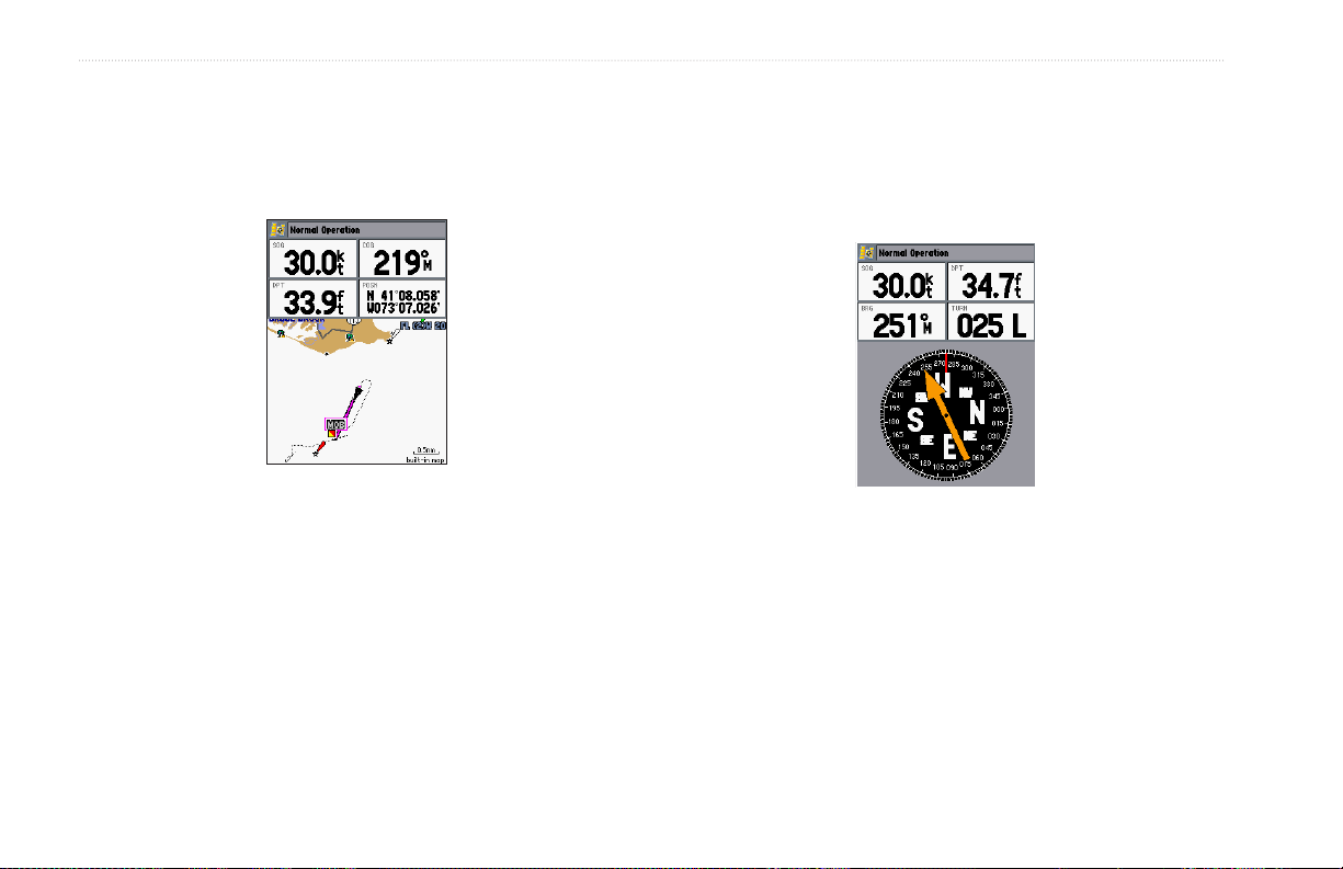
Map Page ................................................................................ 27
Compass Page ....................................................................... 32
3D Highway Page .................................................................. 33
Active Route Page ................................................................. 36
Main Menu ..........................................................................37
GPS Tab .................................................................................. 37
Tide Tab .................................................................................. 40
Trip Tab ................................................................................... 44
Celes (Celestial) Tab ............................................................. 45
Points Tab .............................................................................. 46
Route Tab ............................................................................... 51
Track Tab ................................................................................ 57
DSC Tab .................................................................................. 59
Card Tab ................................................................................. 59
Msgs Tab ................................................................................ 60
Pages Tab ............................................................................... 61
Map Tab .................................................................................. 61
Hiway (Highway) Tab ............................................................. 64
Temp (Temperature) Tab ....................................................... 64
Sonar Tab ............................................................................... 64
Systm (System) Tab ............................................................. 65
Alarm Tab ............................................................................... 70
ii GPSMAP 292/298 Owner’s Manual

INTRODUCTION > TABLE OF CONTENTS
Using Sonar .......................................................................72
Sonar Page ............................................................................. 72
Sonar Tab Options ................................................................ 77
Understanding Sonar ............................................................ 80
Flasher Page .......................................................................... 84
Map Split Page ....................................................................... 85
Appendix ............................................................................86
Specifications ........................................................................ 86
Installing the GPSMAP 292/298 External GPS Antenna ..... 87
Mounting the GPSMAP 292/298 ........................................... 88
Installing the Transducer ...................................................... 90
Connecting the Power/Data Cable ....................................... 92
Interfacing .............................................................................. 93
Caring for the Screen ........................................................... 93
Installing and Removing Data Cards ................................... 94
Satellite Information .............................................................. 95
What is WAAS/EGNOS? ........................................................ 96
What is a Maritime Mobile Service Identity (MMSI)? .......... 97
How Are MMSI Assignments Obtained? ............................. 97
Navigation Terms .................................................................. 98
Messages ............................................................................. 100
LORAN TD System .............................................................. 103
Optional Accessories .......................................................... 105
Software License Agreement ............................................. 106
Product Registration ........................................................... 106
Limited Warranty ................................................................. 107
FCC Compliance .................................................................. 108
Industry Canada Compliance ............................................. 108
Declaration of Conformity (DoC) ....................................... 108
Index .................................................................................109
GPSMAP 292/298 Owner’s Manual iii
INTRODUCTION > WARNINGS AND IMPORTANT INFORMATION
Warning
Failure to avoid the following potentially hazardous situations could
result in an accident or collision resulting in death or serious injury.
When navigating, carefully compare information displayed on the
GPSMAP 292/298
information from visual sightings, and maps. For safety, always resolve any
discrepancies or questions before continuing navigation.
WARNING: This product, its packaging, and its components contain chemicals known to the State of California to cause cancer, birth defects, or reproductive
harm. This Notice is provided in accordance with California’s Proposition 65. See
Hg
- LAMP(S) INSIDE THIS PRODUCT MAY CONTAIN MERCURY AND MUST BE RECYCLED OR DISPOSED OF ACCORDING TO
to all available navigation sources, including
Use the electronic chart in the GPSMAP 292/298 only to facilitate, not
to replace, the use of authorized government charts. Official government
charts and notices to mariners contain all information needed to navigate
safely.
www.garmin.com/prop65 for more information.
LOCAL, STATE, OR FEDERAL LAWS.
Important Information
MAP DATA INFORMATION: One of the goals of Garmin is to provide customers with the most complete and accurate cartography that is available to us at
a reasonable cost. We use a combination of governmental and private data sources, which we identify in product literature and copyright messages displayed
to the consumer. Virtually all data sources contain some inaccurate or incomplete data. In some countries, complete and accurate map information is either not
available or is prohibitively expensive.
iv GPSMAP 292/298 Owner’s Manual

BASIC OPERATION > TURNING ON THE GPSMAP 292/298
BASIC OPERATION
3. Press
Turning on the GPSMAP 292/298
The first time you turn on the GPSMAP 292/298, the receiver
must be given an opportunity to collect satellite data and establish
its present location. To ensure proper initialization, the GPSMAP
292/298 is shipped from the factory in AutoLocate Mode. Before
you turn on the GPSMAP 292/298 unit, make sure the unit and
antenna are correctly installed on your vessel according to the
instructions in the “Appendix.” Install the antenna in a location
with a clear and unobstructed view of the sky.
A full-screen GPS Information Page is shown after you press
ENTER to acknowledge the Warning Page. The page goes away
after the unit gets a position fix, or you press either ENTER or
QUIT.
To turn on the GPSMAP 292/298:
1. Press and hold the POWER key until the power tone
sounds, and then release the POWER key. The title page,
and then the Warning Page appears while the unit conducts
a self-test.
2. When the self-test is complete, press ENTER to agree and
acknowledge the warning.
The GPS Information Page appears as the receiver begins acquiring
satellites.
To turn off the GPSMAP 292/298:
1. Press and hold the POWER key.
2. When the screen is blank, release the POWER key.
ENTER to answer NO to the window asking “Do you
want to start the Retail Demonstration?”. You are only asked
this the first time you start the unit.
GPSMAP 292/298 Owner’s Manual 1
BASIC OPERATION > TURNING ON THE GPSMAP 292/298
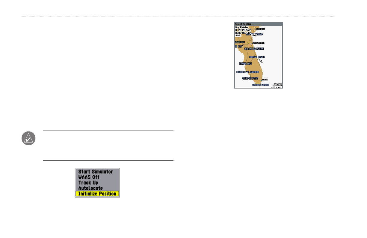
To graphically initialize the GPSMAP 292/298:
1. Press and hold ADJ/MENU for the Main Menu. Press up or
down on the ROCKER until the GPS tab is highlighted, and
then press ADJ/MENU once.
2. Using the ROCKER, highlight Initialize Position, and press
ENTER. The Initialize Position Page appears, prompting
you to select your approximate location with the map
pointer.
3. Use the ROCKER to move the map pointer to your
approximate location within 200 miles. If you have difficulty
identifying your location, press and release the RANGE
Down key to see the next lower map range.
4. After you have determined your approximate location on the
map, press ENTER.
NOTE: This does not calibrate the unit in any way, rather it
helps to speed up the initial satellite acquisition. If the unit
shows “Ready for Navigation” during this process, it is not
necessary to initialize the unit.
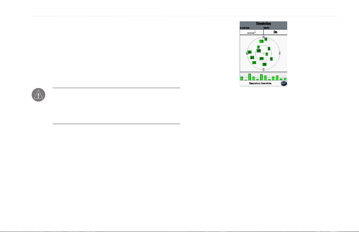
The unit now begins searching for the appropriate satellites for
your region and should acquire a fix within a few minutes. When
viewing the GPS tab on the Main Menu, a signal strength bar for
each satellite in view appears on the bottom of the page, with the
appropriate satellite number under each bar.
• No signal strength bars—the receiver is looking for the
satellites indicated.
• Hollow signal strength bars—the receiver has found the
indicated satellite(s) and is collecting data.
• Solid signal strength bars—the receiver is ready to use.
When the receiver has collected information from at least three
satellites, the top of the screen shows “Ready for Navigation”, and
the GPSMAP 292/298 is ready for use.
2 GPSMAP 292/298 Owner’s Manual
Using Simulator Mode
Simulator Mode turns the GPS receiver off for use indoors or
practice. You can perform any of the functions discussed in
the following pages in Simulator Mode. Keep in mind that the
GPSMAP 292/298 does not track satellites in Simulator Mode,
and this mode should never be used for actual navigation. All the
waypoint and route planning completed in Simulator Mode is
retained in memory for future use.
WARNING: Do not attempt to navigate using Simulator
Mode. When the unit is set to Simulator Mode, the GPS
receiver is turned off. Any satellite signal strength bars shown
are only simulations and do not represent the strength of actual
satellite signals.
BASIC OPERATION > USING SIMULATOR MODE
To place the GPSMAP 292/298 in Simulator Mode:
1. Press and hold ADJ/MENU to show the Main Menu.
Press up or down on the ROCKER until the GPS tab is
highlighted, and then press ADJ/MENU once.
2. Use the ROCKER to highlight Start Simulator, and press
ENTER.
3. Press QUIT to confirm the Running Simulator message
that appears at the bottom of the screen. If the status bar
is turned on, “Simulating” appears at the top of each of the
main pages.
4. To turn off the Simulator Mode, press ADJ/MENU, and
select Stop Simulator.
GPSMAP 292/298 Owner’s Manual 3
BASIC OPERATION > ADJUSTING THE BACKLIGHT
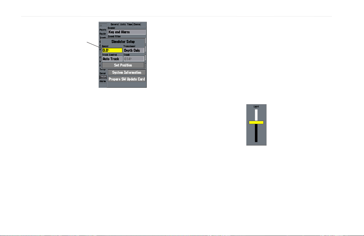
The Set Position,
Track Control, Track
and Speed fields
only show while in
Simulator Mode.
Compass or 3D Highway Pages:
1. Press up on the ROCKER increase the speed in
10 knot/kph/mph increments. Press down on the ROCKER
to decrease the speed in the same increments.
2. Press left or right on the ROCKER to steer the boat.
Adjusting the Backlight
The adjustable screen backlighting is controlled with the POWER
To adjust the simulated speed and heading from the
To enter a simulated speed and heading from the
Main Menu:
1. Press and hold ADJ/MENU to show the Main Menu.
2. Use the ROCKER to highlight the Systm tab, and then
highlight the Setup button next to the Simulator field on the
General sub tab. Press ENTER.
3. Highlight the Speed field, and then press ENTER. Use the
ROCKER to enter a speed, and press ENTER.
4. Use the ROCKER to highlight Track Control. Press
ENTER, and select User Track.
5. Highlight the Track field, and press ENTER. Use the
ROCKER to set the track.
6. Highlight Set Position, and press ENTER to change the
simulated location.
7. Press QUIT until you return to the Map Page.
4 GPSMAP 292/298 Owner’s Manual
key, and can be adjusted from any page.
To adjust the backlighting:
1. Press and release the POWER key. The adjustment slider
window appears.
2. Press the POWER key again and the user-defined level of
backlighting starts. You can adjust this level by pressing up
or down on the ROCKER. If you press POWER one more
time, the backlight is at the maximum setting.
3. Press ENTER or QUIT when finished.
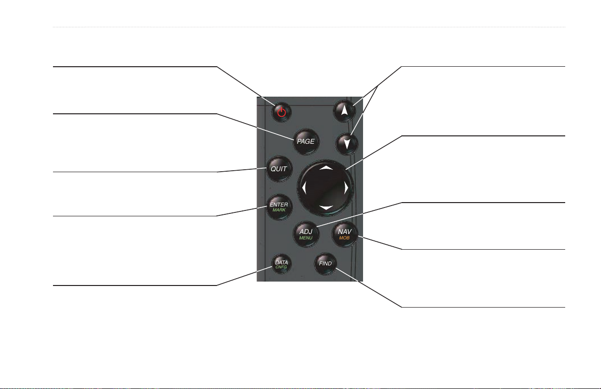
Using the GPSMAP 292/298 Keypad
BASIC OPERATION > USING THE GPSMAP 292/298 KEYPAD
POWER Key
• Press and hold to turn the unit on or off.
• Press and release to adjust backlighting.
PAGE Key
• Press to cycle through the main pages.
• Press to end an operation in progress and
return to the main page.
QUIT Key
• Press and release to cancel data entry or
exit a page.
ENTER/MARK Key
• Press and release to enter highlighted options
and data or confirm on-screen messages.
• Press and hold at any time to mark your
current location as a waypoint.
DATA/CNFG Key
• Press to show or hide function windows and
data fields on any main page.
• Press and hold to open the Main Page
Configuration window.
RANGE Down/RANGE Up Zoom Keys
• From the Map Page, press to zoom
in or out.
• From the Sonar Page, press to scroll up or
down the range list.
ROCKER Key
• Press up, down, right, or left to move
through lists, highlight fields, on-screen
buttons and icons, enter data, or move the
map pointer.
ADJ/MENU Key
• Press and release to view options for a page.
• Press and hold to view the Main Menu.
NAV/MOB Key
• Press and release at any time to
view the Navigation Menu.
• Press and hold for MOB waypoint.
FIND Key
• Press to search for points such as user
waypoints, cities, and services.
GPSMAP 292/298 Owner’s Manual 5
BASIC OPERATION > ENTERING DATA AND SELECTING OPTIONS
Entering Data and Selecting Options
You can select and start options, and enter data to customize the
GPSMAP 292/298 to fit your requirements. Use the ENTER key
and the ROCKER to select options, enter names and numbers in
data fields, and start your selections.
To select an optional feature:
1. From any page, press ADJ/MENU for the adjustment menu.
The adjustment menu shows a list of optional features that
are specific for that page.
2. Use the ROCKER to move the cursor (highlight) up and
down a list or up, down, left, and right on menus.
3. After you have highlighted a selection, press ENTER to start
the feature. Repeat this process to select an option from the
list, or press QUIT to return to the previous setting.
To select an on-screen button:
Some pages contain on-screen buttons. Use the ROCKER
to highlight a button, and press ENTER.
On-Screen buttons
6 GPSMAP 292/298 Owner’s Manual
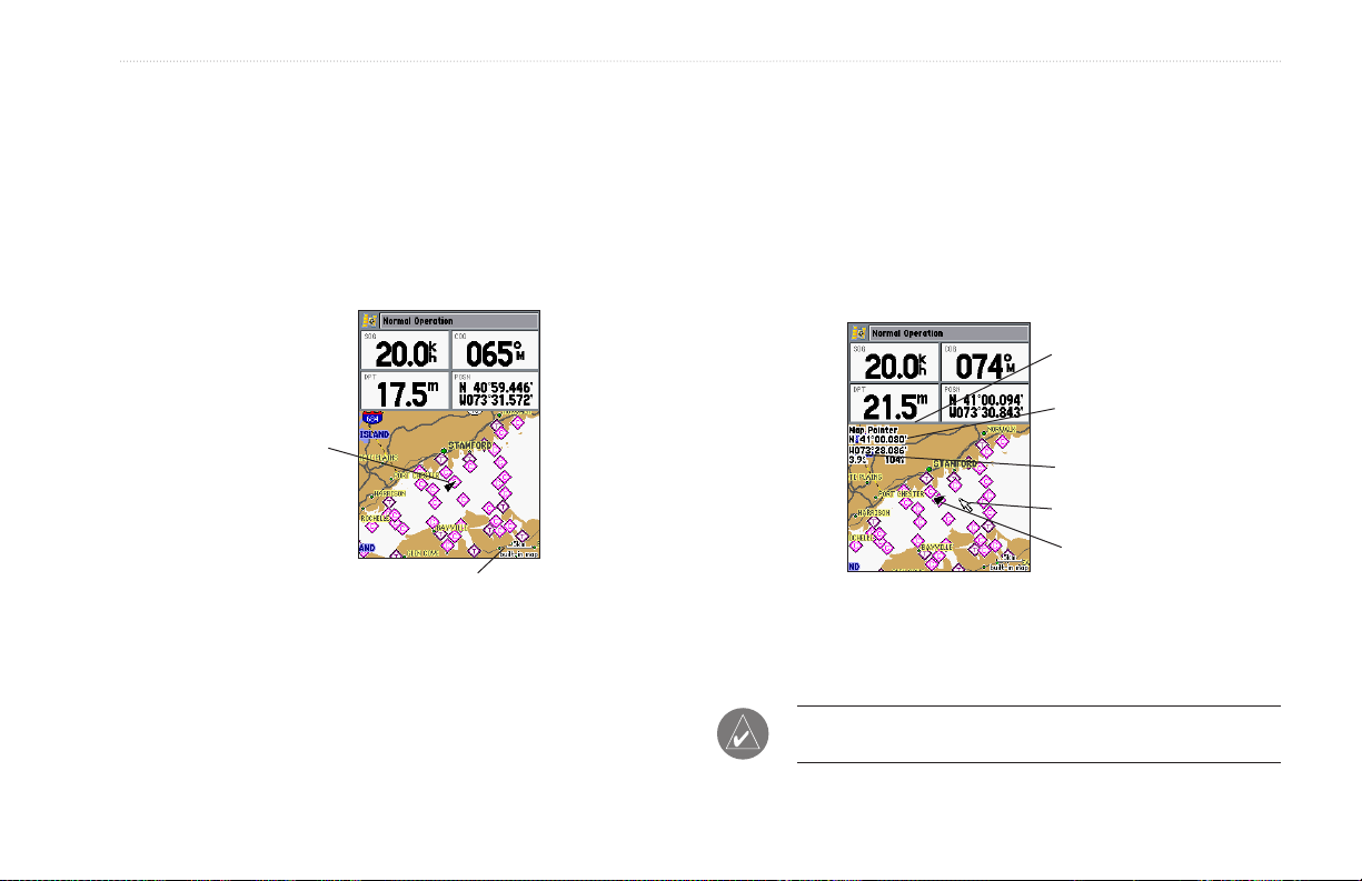
BASIC OPERATION > USING THE MAP POINTER
Using the Map Pointer
Working from the Map Page centers around the use of the map
pointer. Controlled by the ROCKER, the map pointer is used
to pan to map locations, mark and edit waypoints and routes,
and review position data of on-screen map items and waypoints.
When you move the map pointer over a map item, a highlighted
description of that item appears.
Present
location
Map zoom range
The Map Page actively scrolls or pans enabling you to explore
areas around the world and create waypoints and routes. Pressing
QUIT returns the map to your present location.
To pan the map:
1. Use the RANGE Down/RANGE Up keys to select a map
zoom range.
2. Use the ROCKER to move the map pointer. A data field
appears at the top of the screen showing the bearing and
distance from your boat to the map pointer, along with the
latitude/longitude of the map pointer.
3. Press QUIT to re-center your boat on the Map Page.
Depth
Map pointer
coordinates
Distance
Map pointer
Present
location
NOTE: When the map pointer reaches the edge of the map, the
unit can pause as it loads new map data.
GPSMAP 292/298 Owner’s Manual 7

BASIC OPERATION > CREATING AND USING WAYPOINTS
Creating and Using Waypoints
The Garmin GPSMAP 292/298 stores up to 3,000 alphanumeric
waypoints with a user-defined symbol, comments, depth, and water
temp, available for each waypoint. Waypoints can be created using
two basic methods:
ENTER/MARK Key—marks your present location, and provides
options to select a map location or map item from the Map
ENTER/MARK Key
Use the ENTER/MARK key to quickly capture your present
location and create a new waypoint. The unit must have acquired at
least three satellites to mark your present location. You can also use
this option to manually enter waypoint coordinates.
To mark your present position:
1. Press and hold ENTER/MARK until the New Waypoint
Page. Also, you can enter a new waypoint’s location coordinates
manually.
Graphically—defines a new waypoint location from the Map Page
using the ROCKER.
2. To accept the waypoint with the default name and symbol,
3. To enter a different name, highlight the name field, and
4. To select a different symbol, highlight the symbol field to
window appears. A default four-digit name and symbol are
created for the new waypoint.
highlight OK, and press ENTER/MARK.
press ENTER/MARK. Use the ROCKER to enter the new
alphanumeric name, and press ENTER/MARK when
finished. You can use up to 10 characters for the name.
the left of the name, and press ENTER/MARK. Use the
ROCKER to highlight the new symbol, and press
ENTER/MARK.
8 GPSMAP 292/298 Owner’s Manual

BASIC OPERATION > CREATING AND USING WAYPOINTS
5. To enter optional comments or a depth, highlight
Comments, Depth, or Water Temp, and press
ENTER/MARK, use the ROCKER to enter a value, and
press ENTER/MARK.
6. To manually enter a set of coordinates, highlight the
coordinates, and press ENTER/MARK, use the ROCKER to
enter the new coordinates, and press ENTER/MARK when
finished.
7. Use the ROCKER to highlight OK. When finished, press
ENTER/MARK to save the waypoint.
Creating Waypoints Using the Map
To create a new waypoint from a map location:
1. Use the ROCKER to move the map pointer to a map
2. Press and release ENTER/MARK to capture the map
If you are not using a map item to create a waypoint, go to
3. Highlight Create Wpt, and press ENTER/MARK.
4. To accept the waypoint with the default name and symbol,
You create waypoints graphically from the Map Page. To mark
a map location or map item, select the location or item with the
5. To change the name, symbol, or add a comment or depth,
map pointer, and press ENTER. When selecting a location or map
item, a description of the point, its distance and bearing from your
current location, and the latitude/longitude of the map pointer is
shown along the top of the map.
6. Highlight OK, and press ENTER/MARK to confirm the
location. If you want to create the new waypoint at an
on-screen map item, highlight the map item on the screen.
pointer location. Do not hold the button down, because
doing so marks your present location, not the map location.
step 4.
press ENTER/MARK.
highlight the appropriate field, and press ENTER/MARK.
Make your changes, and press ENTER/MARK when
finished.
changes.
GPSMAP 292/298 Owner’s Manual 9
BASIC OPERATION > MAN OVERBOARD (MOB)
Man OverBoard (MOB)
The Man OverBoard function (MOB) simultaneously marks and
sets a course back to the marked location for quick response to
emergency situations.
When a MOB is active, a MOB waypoint with an international
MOB symbol is created and the unit is on an active navigation to
that point. Use any of the Navigation Pages to guide you back to
the MOB point. The MOB waypoint is stored in the waypoint list
and works like any other waypoint.
The MOB function allows you to quickly start
navigation back to a location.
To start the MOB function:
1. Press and hold NAV/MOB.
2. Press ENTER to begin navigating to the MOB location.
3. To stop navigation to the MOB location, press NAV,
highlight Stop Navigation, and press ENTER.
To stop navigation, press NAV/MOB highlight
Stop Navigation, and press ENTER.
10 GPSMAP 292/298 Owner’s Manual
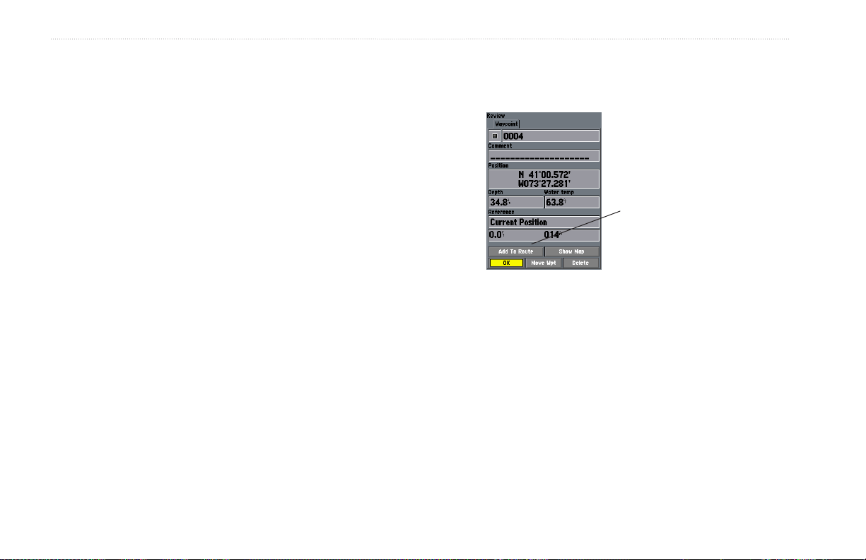
BASIC OPERATION > REVIEWING AND EDITING WAYPOINTS
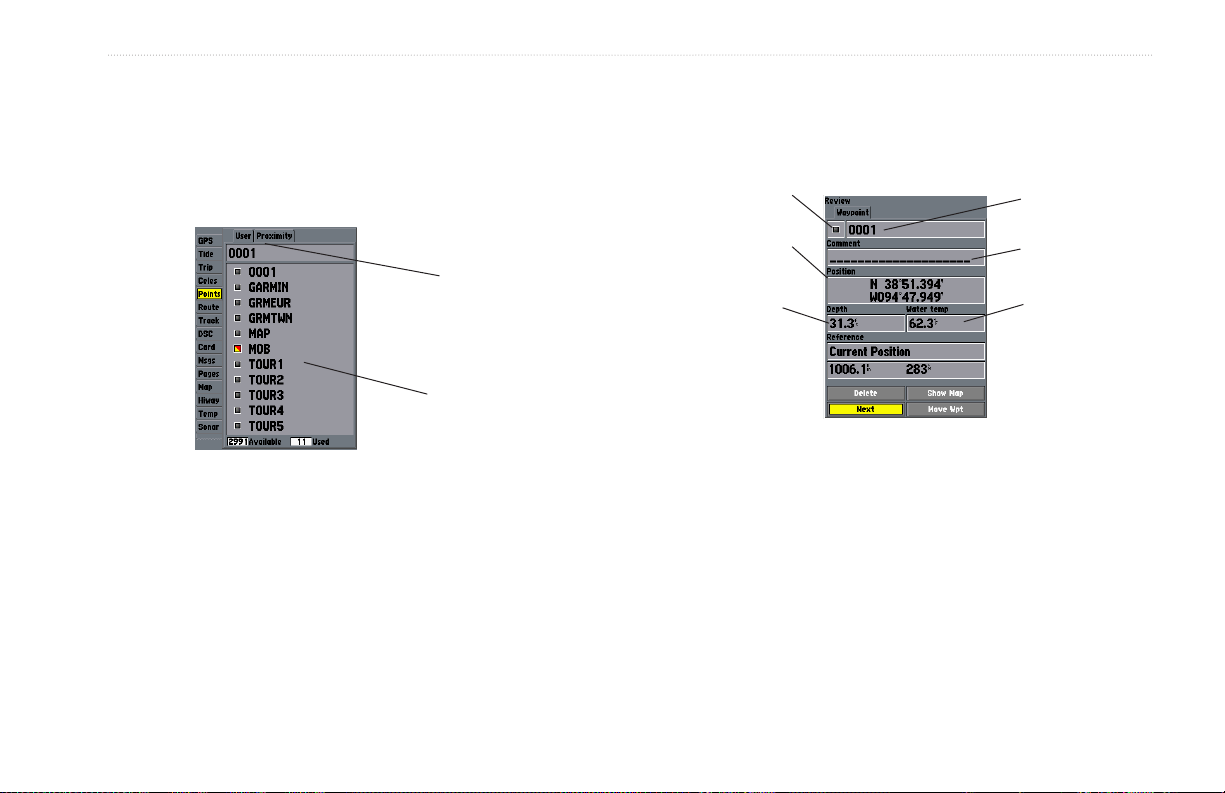
Reviewing and Editing Waypoints
3. From the Waypoint Edit Page, change the name, symbol,
You can review, modify, rename, move, or delete waypoints at any
time using the Waypoint Edit Page. The Waypoint Edit Page is
available for any stored waypoint. Select the waypoint on the map
or from the waypoint lists in the Main Menu—Points tab.
Sub tabs
Waypoint list
To access the Waypoint Edit Page:
1. Use the ROCKER to highlight the waypoint on the Map
Page.
OR
Press and hold ADJ/MENU, highlight the Points tab, and
choose a waypoint from the User or Proximity sub tabs.
2. Press ENTER to show the Waypoint Edit Page.
To change the waypoint name:
1. Highlight the waypoint name field, and press ENTER.
2. Use the ROCKER to enter a new name, and press ENTER
comment, location coordinates, depth, or water temp for the
selected waypoint. When finished, highlight Next, and press
ENTER to save them or press QUIT to cancel.
Symbol
Coordinates
Depth
Waypoint Edit Page
when finished.
Name
Comment
Temp
GPSMAP 292/298 Owner’s Manual 11

BASIC OPERATION > NAVIGATING TO A DESTINATION
To change the waypoint symbol:
1. Highlight the waypoint symbol field to the left of the
waypoint name, and press ENTER.
2. Use the ROCKER to select a new symbol, and press
ENTER.
To change the Comment, Location, Coordinates,
Depth, or Water Temp:
1. Highlight a field, and press ENTER.
2. Use the ROCKER to edit or enter the data. To move to the
next character, press right on the ROCKER.
3. Press ENTER when finished.
To move the waypoint on the map:
1. From the Waypoint Edit Page, highlight Move Wpt, and
press ENTER. A MOVE label now appears under the map
pointer in addition to a distance, bearing, and coordinate
window. You can also use the RANGE Down and RANGE
Up keys to zoom the map. The map zoom range appears in
the lower-right corner.
2. Use the ROCKER to point to the new location, and press
ENTER.
3. To stop the move process, press QUIT.
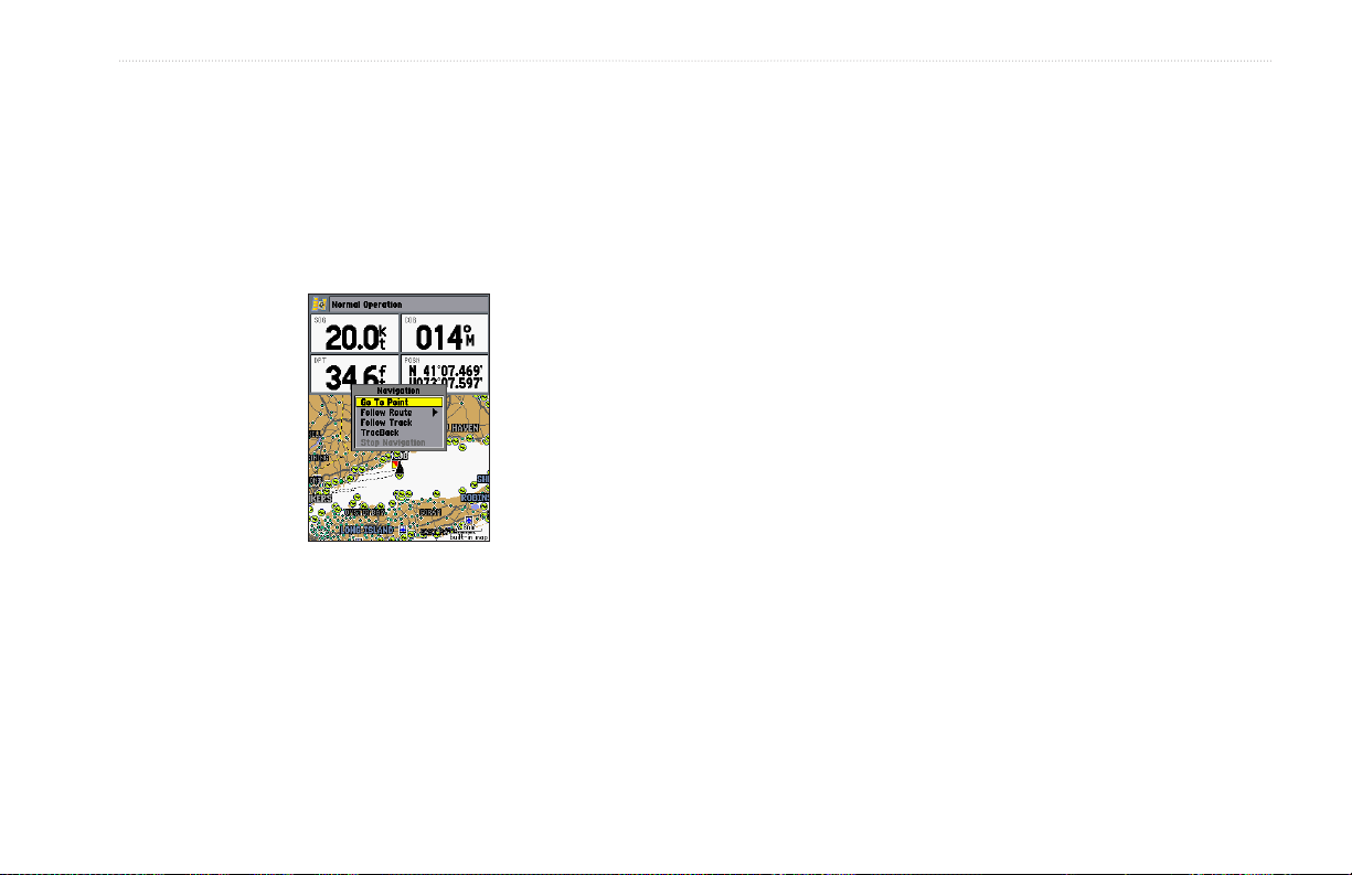
Navigating to a Destination
Using the Nav Key
The NAV key provides four ways to navigate to a destination:
Go To Point, Follow Route, Follow Track, and TracBack. When
you are actively navigating, the Map Page shows a straight line
from your current location to the destination. The Go To option is
the easiest method for selecting a destination. A Go To allows you
to select a destination point and quickly set a direct course from
your present location. If you have a point highlighted on a list or
the map, Go To <point name> appears in addition to Go To Point.
The Go To function is accessed from any list of points or
graphically from the Map Page.
12 GPSMAP 292/298 Owner’s Manual
BASIC OPERATION > NAVIGATING TO A DESTINATION
To start a Go To from a point list:
1. Press NAV. Highlight Go To Point, and press ENTER.
2. From the Find menu, highlight Waypoints or another menu
option, and press ENTER.
3. To select a waypoint from the waypoint lists, use the
ROCKER to highlight either the By Name or Nearest tab,
select a waypoint, and press ENTER.
Selecting a Go To Graphically
A Go To can be used to select one of three items from the Map
Page: an existing waypoint, an on-screen map item such as roads,
rivers, cities, and navaids, or a new map point. If you are selecting
a map item as the Go To destination, the GPSMAP 292/298
automatically uses the name of the map item, but the point is not
stored in the waypoint list. See page 8 for creating waypoints using
map items. If you are selecting a new map point (non-map item) as
the Go To destination, the GPSMAP 292/298 automatically creates
a waypoint at the map pointer location.
To Go To an existing waypoint or map item from the
Map Page:
1. Use the ROCKER to highlight the waypoint or on-screen
map item.
2. Press NAV. Go To <waypoint name> appears.
3. Press ENTER to start navigating to the waypoint.
GPSMAP 292/298 Owner’s Manual 13

BASIC OPERATION > NAVIGATING TO A DESTINATION
To Go To a new map point (non-map item):
1. Use the ROCKER to move the map pointer to location.
2. Press NAV.
3. With Go To MAP Point highlighted, press ENTER.
TracBack Navigation (Navigating a Track)
The TracBack function retraces your path to the starting point
using the track log automatically stored in the receiver’s memory.
This feature eliminates the need to store waypoints along the way.
TracBack routes are created by reducing your track log into a route
of up to 300 turns and activating an inverted route along those
points. When started, a TracBack route leads you back to the oldest
stored track log point, so it is a good idea to clear the existing track
log before you start your current trip.
14 GPSMAP 292/298 Owner’s Manual
BASIC OPERATION > NAVIGATING TO A DESTINATION
To clear the track log:
To show the track on the Map and 3D Highway Pages,
1. Press and hold ADJ/MENU to show the Main Menu.
2. Using the ROCKER, highlight the Track tab, and then
highlight the Active sub tab.
To view the track on the map, highlight Show Map, and
3. Use the ROCKER to select the Clear button, and press
ENTER.
4. Highlight OK, and press ENTER to save the track.
4. Highlight OK, and press ENTER.
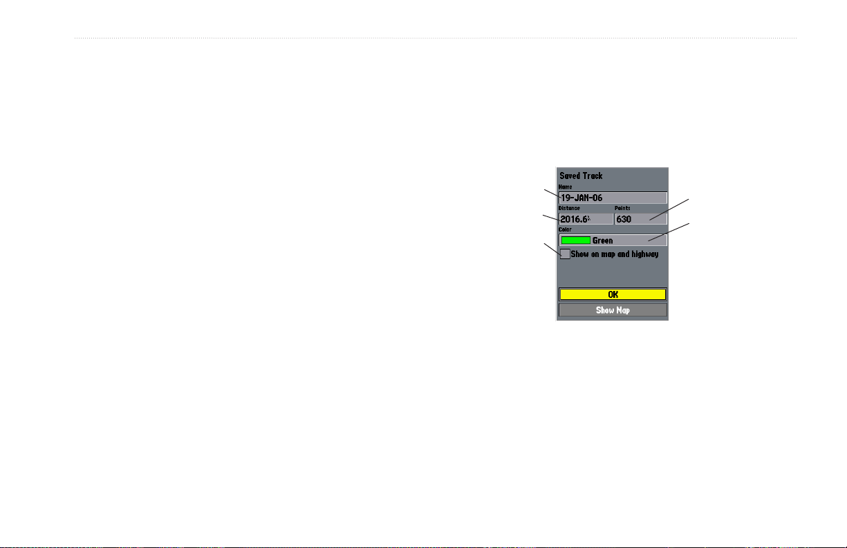
To save a track log:
Default track name
1. From the Main Menu, use the ROCKER to highlight the
Track tab, then highlight the Active sub tab to the right.
2. Use the ROCKER to select Save, and press ENTER.
3. From the Save Back Through window, highlight time,
date, or Entire Log, and press ENTER. When the track is
saved, the Save Track window appears. The default name,
distance, number of points (700 max), and color are shown
in the Save Track window.
To change the name of the saved track, highlight the name
field, and press
ENTER. Make your changes and press
ENTER.
highlight the check box to the left of Show on Map and
Highway, and press ENTER.
press ENTER.
Total number of points
Total distance
Check this box
to show track on
the Map or 3D
Highway Pages
Change color
of track line
GPSMAP 292/298 Owner’s Manual 15

BASIC OPERATION > NAVIGATING TO A DESTINATION
To start a TracBack using the NAV key:
1. Press NAV, highlight TracBack, and press ENTER.
2. To stop TracBack navigation, press NAV, highlight Stop
Navigation, and press ENTER.
• If the track log’s changes in distance and direction are
When a TracBack is active, the GPSMAP 292/298 takes the track
log stored in memory and divides it into segments called legs. Up
to 300 temporary turns (BEGIN, TURN 1, TURN 2, TURN 3,....,
For more information on setting up the Track options and saved
tracks, see pages 57.
TURN X, END) are created to mark the most significant features
of the track log in order to duplicate your exact path as closely as
possible. To get the most out of the TracBack feature, remember
the following tips:
Following a Track
The Following a Track function retraces a track from the
beginning, the oldest time, to the end, the newest time. You can
only use this function with Saved Tracks. To save a track, refer to
• Always clear the track log at the starting point.
the instructions on page 15.
• Set the Record Mode option on the track log setup page to
Fill or Wrap.
• The track log memory must contain at least two points to
create a TracBack route.
• If the track log interval is set to the Time option, the route
To Follow a Track:
1. Press NAV, highlight Follow Track, and press ENTER.
2. Highlight the track you want to follow, and press ENTER.
3. To stop Follow Track navigation, press NAV, highlight Stop
can not follow your exact path. For best performance, keep
the interval set to Resolution.
• If the receiver is turned off or satellite coverage is lost during
your trip, the TracBack draws a straight line between any
point where coverage was lost and where it resumed.
too complex, 300 waypoints might not mark your path
accurately. The receiver then assigns the 300 waypoints
to the most significant points of your track, and simplifies
segments with fewer changes in direction.
Navigation, and press ENTER.
16 GPSMAP 292/298 Owner’s Manual

BASIC OPERATION > ROUTES
Routes
You can create and store up to 50 user-defined reversible routes
(numbered 1-50), with up to 300 waypoints each.
Route Tab
To navigate a QUICK NAV route:
1. Press NAV/MOB, and highlight Follow Route.
2. Press ENTER, and highlight Create QUICK NAV Route.
3. Use the map pointer to select a waypoint or map item, and
press ENTER.
4. To add a new waypoint to the route, use the map pointer to
select a map location, and press ENTER.
As you add each new waypoint to the route, the data
window at the top of the Map Page shows the waypoint/map
item name, bearing and distance from your location, and
coordinates of the map pointer. The bottom of the screen
shows the number of available points. A route line appears
on the map to indicate each completed leg, and a dotted
line appears indicating the distance and bearing to the map
pointer from the last route waypoint.
5. Repeat steps 3 and 4 until you have finished defining all
route waypoints.
6. Press QUIT twice to start your QUICK NAV Route.
To create a route graphically using the map window:
1. Press and hold ADJ/MENU to show the Main Menu.
2. Use the ROCKER to highlight the Route tab, and press
ADJ/MENU to show the route options page
3. Select New Route, and press ENTER.
4. Follow steps 3, and 4 in the QUICK NAV Route instructions.
5. When finished, press QUIT twice to return to the Route List
Page.
GPSMAP 292/298 Owner’s Manual 17

BASIC OPERATION > ROUTES
ADD appears below the map
pointer as you insert points.
To create a route using text on the Route
Review Page:
1. Press and hold ADJ/MENU to show the Main Menu.
2. Use the ROCKER to highlight the Route tab, and press
ADJ/MENU to show the route options menu.
3. Select New Route, and press ENTER.
4. Press ADJ/MENU, select Use List, and press ENTER.
To start a route with the NAV key:
1. From any page, press NAV, using the ROCKER, highlight
Follow Route, and press ENTER. Highlight Pick From
Saved List, and press ENTER.
2. Highlight the route you want to navigate, and press ENTER.
To stop navigation of a route:
Press NAV, highlight Stop Navigation, and press ENTER.
Choose the category you want to
add a route point from.
5. Use the ROCKER to highlight the first available blank route
slot, and press ENTER.
6. Select a category, press ENTER, and select the first point in
your route.
7. Repeat steps 5 though 6 until your route is complete, and
then press QUIT.
18 GPSMAP 292/298 Owner’s Manual

BASIC OPERATION > FIND
The following options are available on the Navigation menu by
pressing NAV while navigating a route:
• Invert Route—reverses the route so you can follow it from
the end point back to the beginning.
• Re-Evaluate Route—recalculates and reactivates the current
route data. Selects the route leg closest to your current
location as the active leg (the active leg defines the current
from and to waypoints).
Find
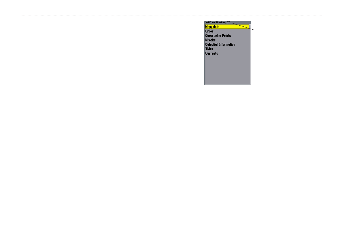
The FIND key searches the unit for user waypoints, map items, and
any optional BlueChart or MapSource information loaded on a data
card. Press FIND to show a list of available find categories. The
default items are Waypoints, Cities, Tides, and Currents. Additional
items, such as Anchorages, Businesses, Exits, Navaids, Restricted
Areas, and Wrecks Obstructions, appear if an optional BlueChart
data card is inserted into the unit. If you press FIND and you are in
Pan Mode, the unit centers its search from the location where the
map pointer is located. Your location or the map pointer must be
within a map outline area to search for BlueChart information.
Find Items List
GPSMAP 292/298 Owner’s Manual 19
BASIC OPERATION > FIND
To Find an item from your current location:
1. From any page, press FIND.
2. Using the ROCKER, highlight a category from the list, and
press ENTER.
3. For Waypoints and Cities, search using By Name or
Nearest. Use the ROCKER to highlight a tab. For By
Name, use the top field to spell out the name, or scroll down
through the list. (See page 8 for steps on entering a name.)
To Find an item from other locations:
1. From the Map Page, use the ROCKER to pan select a
location, and press FIND.
2. Using the ROCKER, highlight a category from the list, and
press ENTER.
You can also Find
items from the Map
Pointer.
The Find option also supports a “find from” feature that centers
your search around an item you have just found. For example,
you search for “Restricted Areas” and you find a point named
“Anchoring Prohibited.” If you press FIND again, “From
Anchoring Prohibited” appears as the new search from point.
20 GPSMAP 292/298 Owner’s Manual
BASIC OPERATION > ADDITIONAL INFORMATION AND DSC
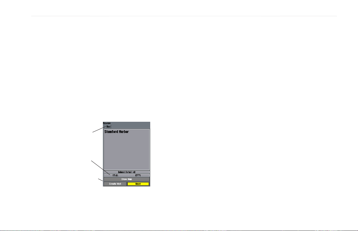
Additional Information
Items located using the map have information about the point
available. The information varies depending on the type of data
loaded on the optional data card. Sub tabs along the top of the
detail window contain the information available for the item. Any
additional options are shown along the bottom.
To view additional information for a Map item:
1. On the Map Page, use the ROCKER to highlight a map
item, and press ENTER.
2. Use the ROCKER to highlight the individual tabs, and show
the information. To scroll the text, highlight the field, and
press ENTER. Use the ROCKER to scroll.
Additional
information tabs
Distance, Bearing,
and Coordinates of
item
Additional options
Information Window
DSC
The DSC Page of the Main Menu controls and sets up the Digital
Selective Calling (DSC) features on the GPSMAP 292/298.
Digital Selective Calling (DSC) uses marine VHF radio and
Global Positioning System (GPS) technologies to transmit and
receive location information. The chartplotter repeats the call
properties received from the VHF radio on the chartplotter. The
GPSMAP 292/298 requires input from a DSC enabled VHF radio
to show position, and sound/show alerts from a Distress Call or
Position Report. Conversely, the VHF radio requires input from a
GPS to transmit position coordinates for a Distress Call or Position
Report. For connection information, refer to “Connecting the
Power/Data Cable” on page 92.
An emergency DSC Distress Call allows a vessel in trouble
to transmit a substantial amount of information in a single
transmission or call, without the need for voice communication.
When any nearby rescuer receives the DSC signal, an alarm sounds
and they immediately receive the location of the caller. The rescuer
can choose to navigate to the caller’s location to assist, or forward
the call on to the Coast Guard or other rescue operation specialist.
GPSMAP 292/298 Owner’s Manual 21
BASIC OPERATION > DSC
When the rescuer receives the call, they can immediately access the
caller’s information (such as who they are and the type of vessel) in
their database while they are in transit to the caller’s location.
A non-emergency DSC Position Report allows mariners to
exchange and show the positions of one another. When a DSC
position is received, the mariner can choose to create a waypoint or
to show the received location on an electronic map.
Anytime a vessel receives a DSC call, they can store and quickly
navigate to that location using a Go To. In order to use DSC, users
must first register their VHF radio with the FCC and receive a
Maritime Mobile Service Identity (MMSI) number. Garmin does
not provide MMSI numbers.
For more information about Digital Selective Calling and Maritime
Mobile Service Identity (MMSI) numbers, refer to page 97 in the
“Appendix.”
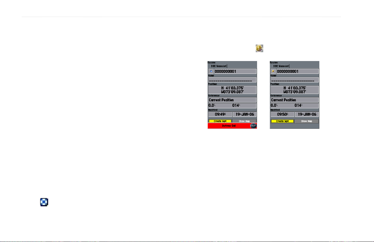
Understanding Distress Calls
When the GPSMAP 292/298 receives a Distress Call from
a connected DSC enabled VHF radio, an alert message and
notification page are shown, and an alarm tone is sounded. Distress
Calls are shown in the DSC Call List, and Log with a checkered
symbol .
22 GPSMAP 292/298 Owner’s Manual
Understanding Position Reports
A Position Report is similar to a Distress Call except no alarm is
sounded. Position Reports are not broadcast to all DSC users and
are shown with a boat symbol .
Receiving DSC Calls
Each time you receive a Distress Call or Position Report, a
Notification Page is shown, and the call is placed in the DSC Call
List and Log. The Notification Page contains information about
the call including: the type of call (distress or position report),
the MMSI number of the caller, a user definable name, the time
and date of the call, the Bearing and Distance from your current
location, and the coordinates of the caller. To see the caller’s
location on a map, select the Show Map button. To create a
waypoint at the caller’s location, select the Create Wpt button. To
close the Notification Page, press QUIT.

BASIC OPERATION > DSC
When a Distress Call or Position Report is placed in the Call List
and Log, the information on the Notification Page is retained.
To review a DSC call or log entry, highlight the entry and
press ENTER. The DSC Entry Review Page is identical to the
Notification Page with one exception, the entry can be deleted.
DSC Call List
The DSC Call List shows the 50 most recent calls, even if the unit
is left unattended. The Call List shows the most recent call from a
vessel. If a second call from the same vessel is received, it replaces
the first call in the Call List. Press MENU to sort the list and delete
entries.
DSC Log
When DSC calls are received, they are automatically placed in the
Log, with the most recent call at the top. The unit can log up to 100
calls. When 100 calls are logged, the oldest log is removed when a
new call is received. Press MENU to sort the list and delete entries.
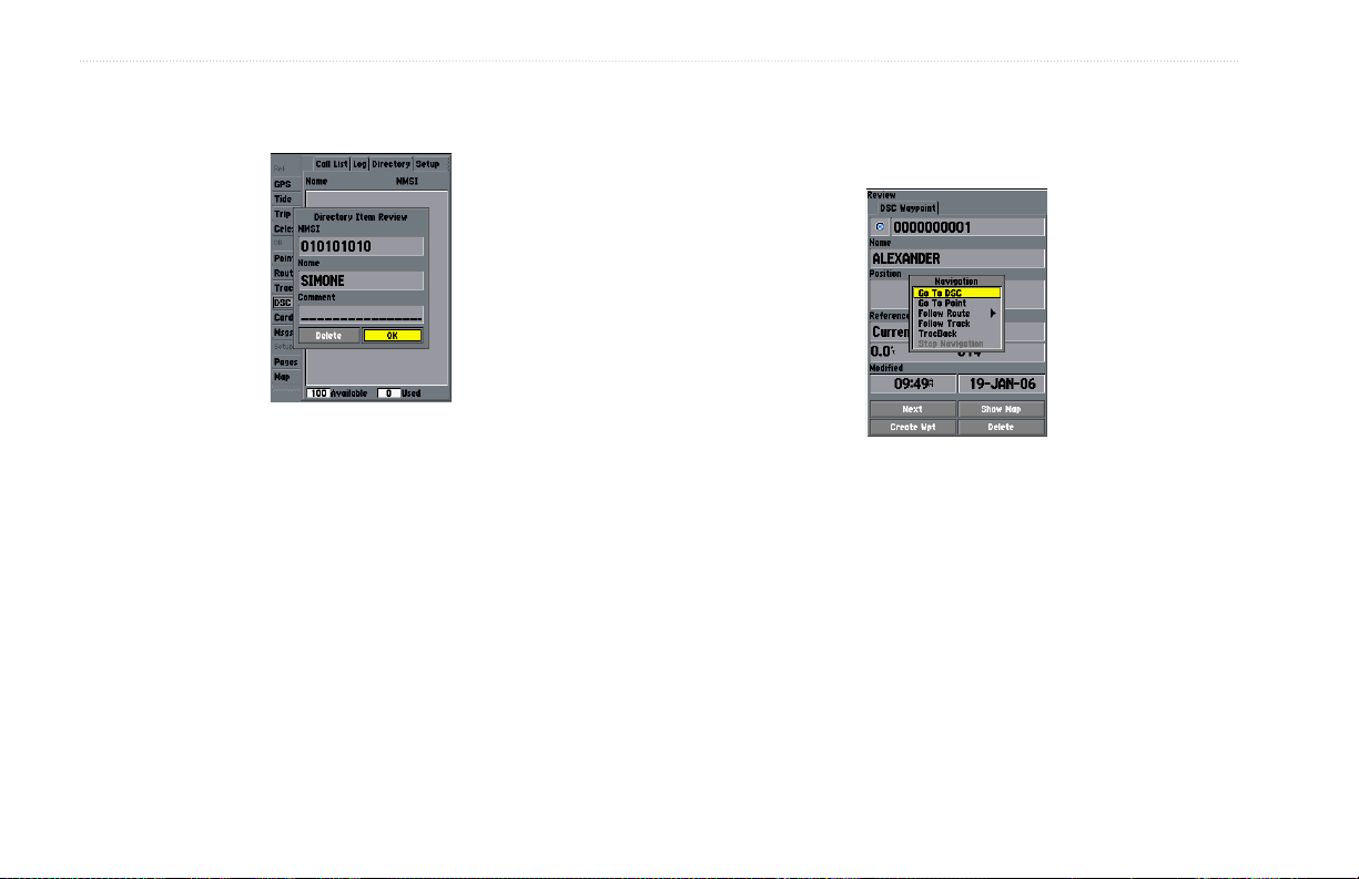
DSC Directory
The DSC Directory acts much like a phone book and can hold up
DSC Entry Review Page
to 50 entries. Pressing MENU from this page shows options to add
a New Item, Delete a highlighted entry, or Delete All entries.
To review a call or log entry:
1. Press and hold ADJ/MENU.
2. Open the Call List or Log from the DSC tab.
3. Press up or down on ROCKER to highlight the call you want
to review.
4. Press ENTER to open the DSC Entry Review Page.
To add a new Directory entry:
1. Open the DSC Directory in the Main Menu.
2. Use the ROCKER to highlight the first blank space in the
directory list, and press ENTER.
OR
Press MENU, highlight New Item, and press ENTER.
GPSMAP 292/298 Owner’s Manual 23
BASIC OPERATION > DSC
3. Enter the MMSI number, a Name, and any comments.
4. When finished, highlight OK, and press ENTER.
Navigating to a Position Report or Distress Call
After a Position Report or a Distress Call is received, navigation
can be quickly set to the call location.
New Directory Item Page
When a Distress Call, Position Report, or Directory item is named,
the name is attached to that particular MMSI number. If a name is
used, all DSC entries of the same MMSI number show the name.
To navigate to Position Report or Distress Call:
1 Press NAV.
2. With Go To MMSI/Name highlighted, press ENTER.
OR
1. Highlight the call on the Call List or Log, and press NAV.
2. With Go To MMSI/Name or DSC highlighted, press ENTER.
Navigating to a DSC Call
24 GPSMAP 292/298 Owner’s Manual
 Loading...