

Page 1
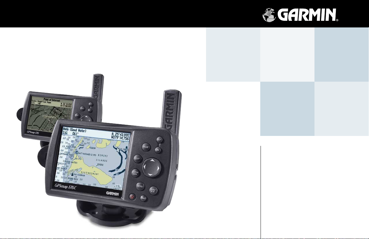
GPSMAP 176C/176
chartplotting receiver
quick
start
guide
Page 2
Quick Start
Unit Overview
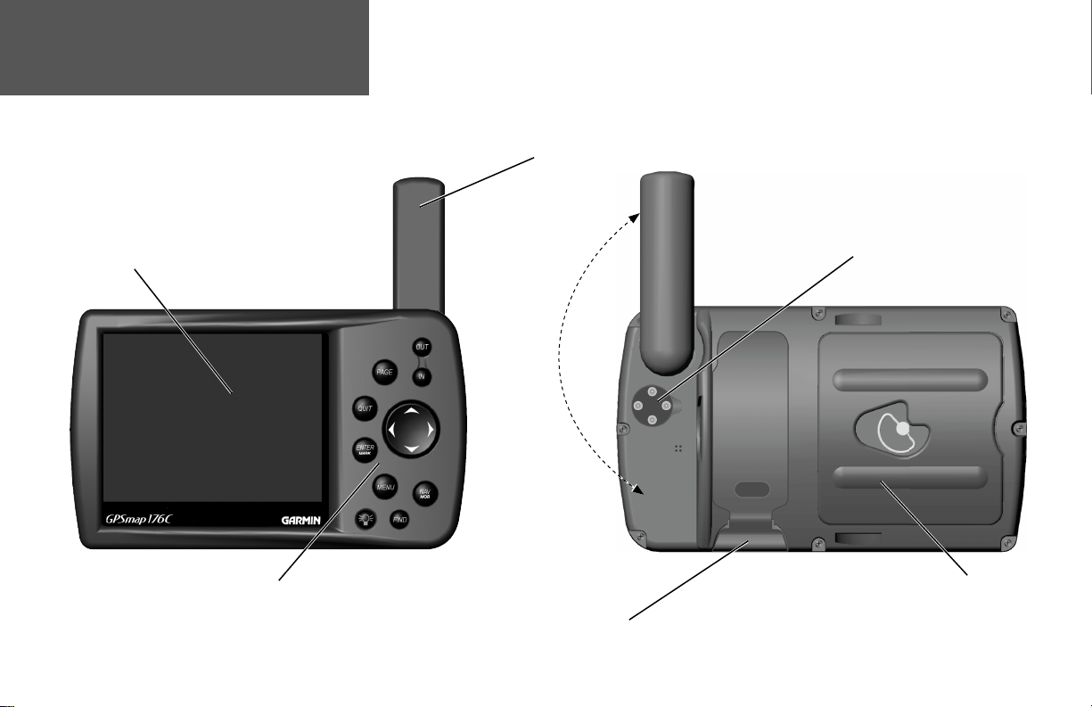
12-level Grayscale LCD Display with Backlight (176)
16-color T ransfl ective Display with Backlight (176C)
Backlit Keypad for easy night operation
GPS Antenna
e
g
a
r
o
t
S
r
o
f
n
o
i
t
i
s
o
P
n
w
o
D
o
t
a
n
n
e
t
n
A
e
t
a
t
o
R
Port for optional Data Storage Card
External Power
and Computer Data Port
Battery Compartment
2
Page 3
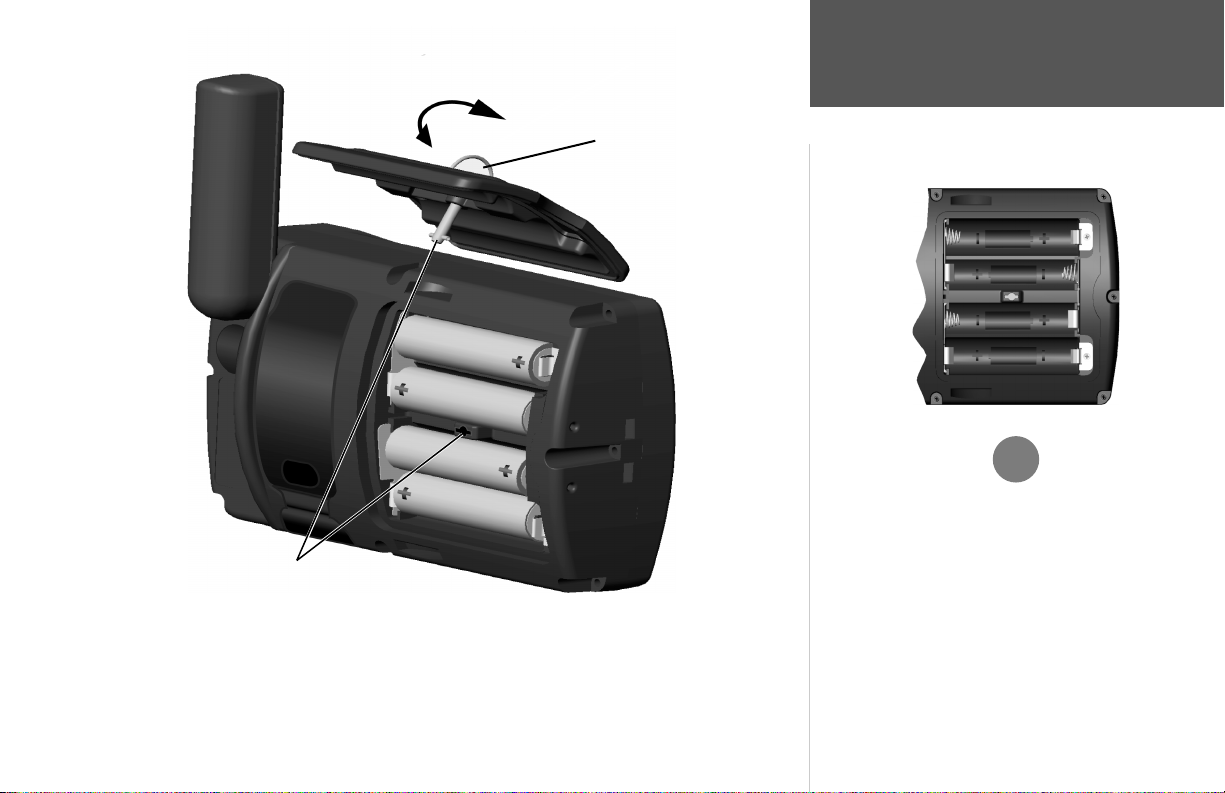
To reinstall the battery lid, place the locking pin into
the slot and rotate the D-ring 1/4 turn clockwise.
To remove the battery lid, rotate the D-ring 1/4
turn counterclockwise, and pull away.
Quick Start
Battery Installation
,
WARNING: It is very important to install ALL batteries with
the proper polarity, positive (+) or negative (-) orientation, as
indicated in the unit’s battery compartment. Batteries can leak
and cause personal injury and property damage if not installed
correctly.
The GPSMAP 176 uses 4 AA batteries, which can be Alkaline, rechargeable, Lithium or Ni-Cad.
Immediately after installing new batteries, turn the unit on to ensure that the unit’s power indicator
shows a fully charged battery condition (see page 49 of the Owner’s Manual). Replace all batteries at
TIP: The GPSMAP 176 saves user data in nonvolatile
memory and will not lose data when the batteries are changed
or if stored without batteries.
the same time. Do NOT mix new and used batteries. Do NOT mix Alkaline batteries with Lithium or
Ni-Cad rechargeable batteries.
3
Page 4
Quick Start
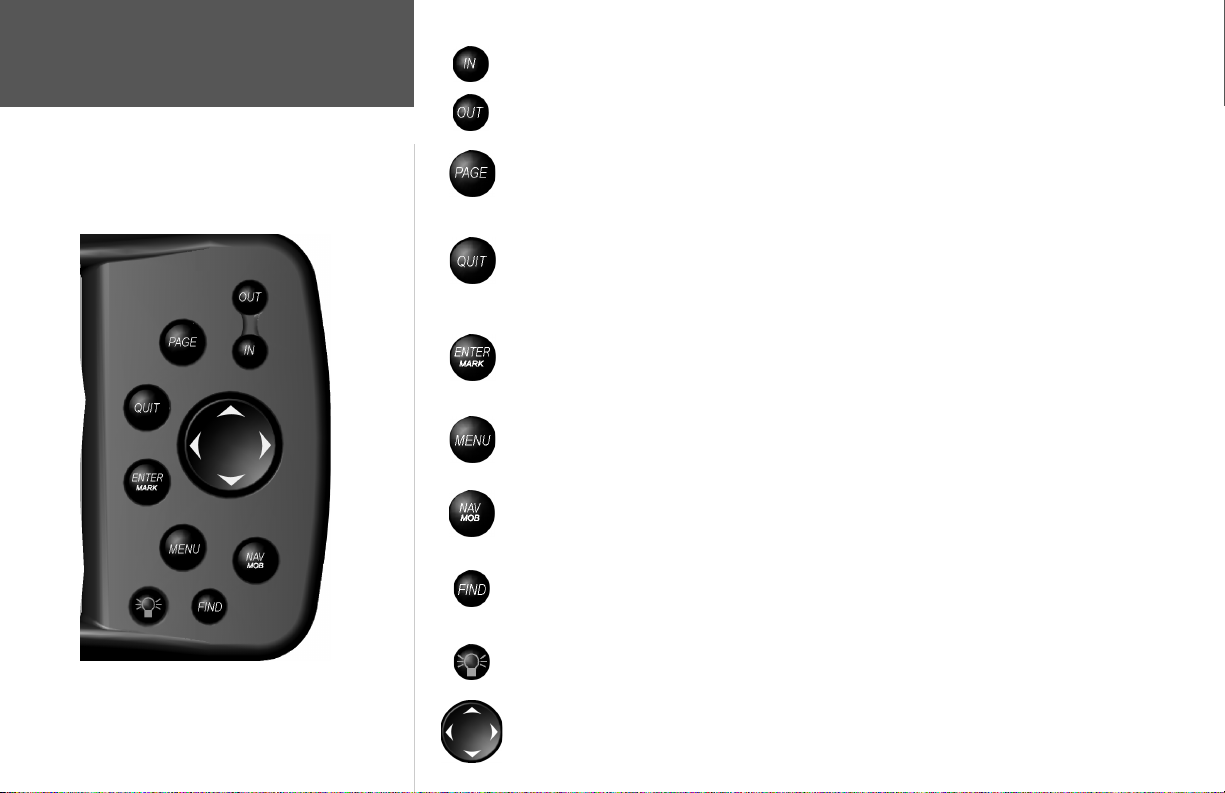
The IN key — adjusts the map scale to show a smaller area with more detail. (Zooms in)
The OUT key — adjusts the map scale to show a larger area with less detail. (Zooms out)
Learning the Keypad
4
The PAGE key — cycles the unit through the main display pages in sequence and returns
the display from a submenu page.
The QUIT key — cycles the unit through the main display pages in a reverse sequence,
re-saves the previous value in a data entry fi eld, or cancels an unintended function such as a
GOTO.
The ENTER key — selects a highlighted menu option. When entering data, it allows you to
initiate entry, and then to accept the selected value(s). It also marks the current location of a
waypoint when pressed and held for more than one second.
The MENU key — displays a menu of available options for the current page, Pressing the
MENU key twice will display the Main Menu.
The NAV/MOB key — displays the Navigation Menu. It also activates the MOB (Man
OverBoard) function when pressed and held for more than one second.
The FIND key — allows you to quickly access User Waypoints, Cities, Points of Interest,
Services and other items used for navigation.
The POWER key — is used to turn the unit on and off and to activate the backlight. It is
also used to adjust the contrast.
The ARROW KEYPAD — is used to select (highlight) menu options and enter data. It also
controls cursor movement on the Map Page.
Page 5
This exercise provides you with the knowledge and skill to confi dently navigate the pages and
menus of your GPSMAP 176.
As you progress through this Quick Start and the Owner’s Manual, you will often be directed to
press a specifi c key or highlight a fi eld. When you are directed to press a key, you should press, then
release the key. If the key needs to be held down for a period of time, the instruction will tell you to do
so. The position of the highlight is controlled by the ARROW KEYPAD. When a fi eld is highlighted, a
dark strip will encompass the fi eld.
Turning the GPSMAP 176 On
To turn the unit on, press the POWER/BACKLIGHT key. The POWER/BACKLIGHT key is
labeled with a red light bulb. As the unit powers on a “Warning/Info Page” will be displayed. To
acknowledge that you have read and understand the warning, press the ENTER key.
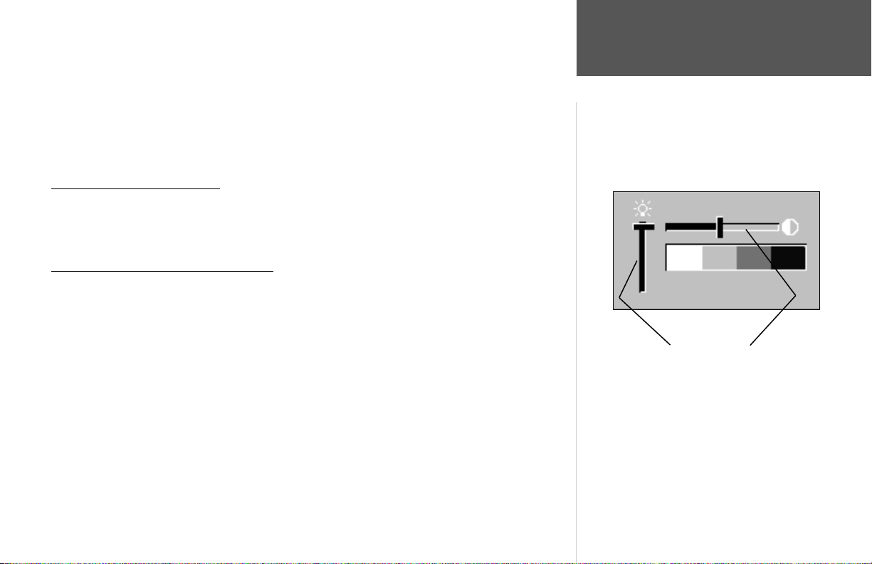
Backlight and Contrast Adjustment
You may need to adjust the Backlight or Contrast to see the display better. To display the Backlight/
Contrast adjustment window, with the unit on, press the POWER/BACKLIGHT key.
To adjust the backlight level:
1. With the Backlight/Contrast adjustment window displayed, press the ARROW KEYPAD UP to
increase the brightness of the backlight, or DOWN to decrease the brightness of the backlight.
Or...
2. Press the POWER/BACKLIGHT key. When the POWER/BACKLIGHT key is pressed repeatedly, the
backlight will cycle between ‘Off’, ‘the last setting’ and ‘full On’.
To adjust the contrast setting:
1. With the Backlight/Contrast adjustment window displayed, press the ARROW KEYPAD RIGHT to
increase the contrast (darker) or LEFT to decrease the contrast (lighter) setting.
Quick Start
Power On/
Backlight and Contrast
Backlight Contrast
5
Page 6

Quick Start
Activating the Simulator
With the GPS Info tab displayed, pressing the MENU key
will display the options for the page. To start the simula-
tor, verify the selection “Start Simulator’ is highlighted
then press the ENTER key.
Using the GPSMAP 176
The keys are your link with the GPSMAP 176. Let’s take a few minutes and use each key so that you
can get a feel for their use before doing any live navigation.
Each time the GPSMAP 176 is turned on the GPS Info tab will be displayed showing the current
satellite status. If you press the PAG E or QUIT key, the GPS Info tab will be hidden and no longer
show in the Main Page cycle.
While learning the basic operation of the GPSMAP 176, let’s put the unit into Simulator Mode. The
Simulator Mode is great for practicing with the unit while indoors and when satellite signals are not
available. When the GPSMAP 176 is in Simulator Mode, the GPS receiver is turned off. This will help
conserve battery power, but the unit cannot be used for actual navigation in simulator mode.
NOTE: Do not try to navigate using the Simulator Mode. While in the Simulator Mode,
)
the GPS receiver is turned off. Any Satellite Signal Strength Indicators displayed are only
simulations and do not indicate the strength of actual satellite signals.
Activating the Simulator Mode
Putting the GPSMAP 176 in simulator mode:
1. With the GPS Info tab displayed press the MENU key.
2. ‘Start Simulator’ should be highlighted, if not, using the ARROW KEYPAD, highlight it and press the
ENTER key.
When the Simulator Mode is active, the message “Simulating GPS” will be displayed in the Status
Field along the top of the GPS Info tab. Press the PAG E key to display the Map Page.
6
Page 7

Main Display Pages
There are fi ve Main Display Pages: the Map Page, Compass Page, Highway Page, Active Route
Page, and Numbers Page. Pressing the PAGE key will display the next Main Page. Press the PAGE key
several times to look at the Main Pages. The QUIT key will allow you to cycle through the Main Pages
in a reverse sequence.
Quick Start
Main Pages/
Features
PAGE PAGE PAGE
Map Page Compass Page Highway Page Active Route Page Numbers Page
QUITQUITQUIT
Features and Entering Data
Cursor— A highlighted area on the screen which can be moved UP/DOWN/LEFT/RIGHT with the
ROCKER KEYPAD to select individual fi elds on the display. Moving the cursor to a given location
allows you to begin data entry or scroll through a list.
Default— A system-selected format, built into the operating software of the unit’s memory, that will
be followed unless the user chooses a different setting. For example, the default setting for distance
and speed units is Statute (miles/miles per hour/feet) but can be changed to Metric or Nautical. Once
a setting is changed, the new setting is retained until another change is made or the ‘Restore Original
Settings’ menu option is selected.
PAGE
QUIT
7
Page 8

Quick Start
Data Entry/
Waypoints
On-Screen Buttons
Field— The location on a page where a group of characters or an option is entered and displayed.
The cursor is placed on a fi eld (using the ROCKER KEYPAD) to begin data entry or select options.
To enter data in a data fi eld:
1. Use the ROCKER KEYPAD to highlight the desired data fi eld. Press ENTER to begin data entry.
2. Use the ROCKER KEYPAD to enter the desired data. Move UP/DOWN to select the desired character
and RIGHT to move to the next character fi eld. LEFT allows you to back up to the previous character
fi eld or, when at the left-most character fi eld, to clear the entire data fi eld.
On-Screen Button— Similar to ‘Field’. Place the cursor on a button and press ENTER to select the
action corresponding to the button. An example of an on-screen button is the ‘Show Map’ button at the
bottom of the Waypoint Edit page (see example at left).
Scroll Bar— When viewing a list of items too long to display on a single page, a scroll bar will
appear along the right side of the list (see example at left). The position of the scroll bar indicates which
portion of the list is currently being displayed. The height of the scroll bar indicates the number of items
in the list. To scroll through a list of items, press UP/DOWN on the ROCKER KEYPAD.
Creating and Naming Waypoints
There will be many times that you may need to select a menu item and/or enter data. An example is
naming a waypoint. The ARROW KEYPAD is used to navigate through menu items and to enter data.
We will create a new waypoint, enter a waypoint name, and assign a symbol to the waypoint using
the ARROW KEYPAD.
The term “waypoint” may be new to you. A waypoint is a location saved in the unit’s memory so it
can be used for navigation. Waypoints can be used for direct navigation, or to build a Route.
Creating or “marking” a waypoint with the GPSMAP 176 is easy. The unit has to be turned on and
receiving at least three satellites or be in Simulator Mode to mark a waypoint.
8
Scroll Bar
Page 9

“Marking” a waypoint:
1. Press and hold the ENTER key.
When the ENTER key is held, the ‘Mark’ function of the key is activated and the GPSMAP 176
captures its current location, and displays the New Waypoint Page. Notice that the unit assigned a
square as the default symbol and a number as the default name. The ‘OK’ Button along the lower right
is highlighted, pressing the ENTER key will save the new waypoint using the default settings for the
symbol and name, but for practice we will change them.
Changing the waypoint symbol:
1. Using the ARROW KEYPAD, highlight the Symbol fi eld, then press the ENTER key.
2. Using the ARROW KEYPAD, highlight the ‘Scenic Area’ symbol, then press the ENTER key.
Changing the waypoint name:
1. Using the ARROW KEYPAD, highlight the Name fi eld, then press the ENTER key.
Symbol Field Name Field Comment Field
The Name fi eld will become active and the fi rst zero will be highlighted. Notice that there are now
ten placeholders for alpha-numeric characters displayed.
2. Press the ARROW KEYPAD to the LEFT to clear the fi eld.
3. Press the ARROW KEYPAD UP, scroll through the alpha-numeric list until the letter ‘C’ is selected.
4. Press the ARROW KEYPAD RIGHT to move to the next placeholder.
5. Press the ARROW KEYPAD DOWN, scroll through the alpha-numeric list until the letter ‘R’ is
selected.
Current Location
You should be starting to get the feel of it. Continue entering letters to spell the word CREEK.
Quick Start
Creating a Waypoint
up to 20 characters
‘OK’ Button
6. With the letter ‘K’ highlighted, press the ENTER key to accept the name.
9
Page 10

Quick Start
Creating a Waypoint/
Navigation
When you have fi nished renaming the waypoint you will need to save it in the unit’s memory.
To save the waypoint:
1. Using the ARROW KEYPAD, highlight the ‘OK’ Button and press the ENTER key.
These are the same steps that you will use to enter names, change numbers and select options in all
of the data fi elds in the GPSMAP 176.
Bearing and distance from Map Pointer to
current GPS location.
Map Pointer
10
Here are a few tips:
1. If you press and hold the ARROW KEYPAD while scrolling through the alpha-numeric list it will
move through the list quickly.
2. You can scroll through the alpha-numeric list in either direction.
3. Don’t press the ENTER key until you have fi nished entering the data. Remember, use the ARROW
KEYPAD to move to the next placeholder.
You should now have enough knowledge to look through the main pages, and enter data into your
GPSMAP 176. Now let’s learn how to navigate!
Navigating with your GPSMAP 176
The main use of a GPS is to be able to navigate to a known position. Let’s create another waypoint
on the Map Page using a different method, the Map Pointer.
Press the PAGE key until the Map Page is displayed. Press the IN key several times until the Zoom
Scale in the lower left corner of the Map Page reads “300 ft”. The current GPS location is indicated by
the triangle in the center of the map.
Page 11

To display the map pointer:
1. Press the ARROW KEYPAD any direction.
Using the ARROW KEYPAD you can pan the Map Pointer around the map. As you move around
the map, the direction and distance from the Map Pointer to the current GPS location is displayed along
the top of the map.
To mark a waypoint using the map pointer:
1. With the Map Pointer at a location on the map about one mile from your current location, and not on
a road or map feature, press and quickly release the ENTER key.
The location of the Map Pointer will be captured and the New Map Waypoint Page will be displayed. Change the waypoint name to “MAP 1”, and save the waypoint by highlighting the ‘OK’ Button
and pressing the ENTER key. Press the QUIT key to hide the Map Pointer and center the map on the
current GPS location. Press the OUT key until the Zoom Scale reads “800ft”.
Now that we have a destination, navigating to it is just a step away.
Going to a waypoint:
1. Press the NAV key.
2. Highlight ‘Go To Point’ then press the ENTER key.
3. Highlight ‘Waypoints’ then press the ENTER key.
4. Highlight ‘MAP 1’ then press the ENTER key.
5. Highlight the ‘Goto’ Button then press the ENTER key.
The GPSMAP 176 is now navigating to the waypoint ‘MAP 1’.
For a GPS to navigate it has to be moving. Fortunately you can simulate movement in the GPSMAP
176. Press the PAG E key until the Compass Page is displayed. Along the right side of the Compass
Page there are several data fi elds. Notice the Speed Field located at the top. To simulate movement,
press the ARROW KEYPAD up one time. This will set a speed of 10 miles per hour. If you continue
to press or hold the ARROW KEYPAD, the speed will increase in 10 mph increments. For this
exercise, 10 mph is fi ne.
Quick Start
Simulated Navigation
Headed Directly Toward Destination
Off Course, Turn Right to Correct
11
Page 12

Quick Start
Simulated Navigation
Receiver Status
Light colored bars indicate the receiver is collecting data from that
satellite. When the bar turns solid, the receiver has collected the
satellite data and is able to use that satellite for navigation. When
the GPSMAP 176 is able to use at least 3 satellites, the Receiver
Status will display “2D or 3D GPS Location”.
The Compass Page features a Pointer and a Compass Ring. When you are moving, the Pointer will
point toward your destination (Bearing) while the Compass Ring refl ects the direction that you are
traveling (Track). In short, when you are headed directly toward your destination, the Pointer will be
pointed toward the top of the display, aligned with the vertical line displayed in the Compass Ring. If
you are not heading toward your destination, the Pointer will turn, continuing to point toward your
destination. To head toward your destination again, turn toward the Pointer until it is realigned with
the vertical line in the Compass Ring and pointed toward the top of the display.
The Simulator allows you to change the Track so you can see how this works. Press the
ARROW KEYPAD to the right until the Track has changed about 50°. This will simulate a direction change to the right. The Pointer should now be pointing toward the left side of the display. This is exactly what will happen during actual navigation when you move off course. Press
the ARROW KEYPAD to the left, simulating a left turn, until the Pointer is realigned with the vertical
line in the Compass Ring. You are now once again headed directly toward the destination waypoint.
Now that we have gone through the basic operation of the unit using the Simulator, it is time to do
some actual navigation!
To turn off the simulator:
1. Press MENU twice to display the Main Menu.
2. Highlight the GPS tab and press MENU.
3. Highlight ‘Stop Simulator’ and press ENTER.
OR:
1. Turn the unit off and back on. The unit will not turn on in Simulator mode.
12
Page 13

Initializing the GPS Receiver
Before the GPSMAP 176 can be used for navigation the receiver has to be initialized. This process is
automatic and will only take a few minutes.
Take the unit outside where it will have an unobstructed view of the sky and turn it on. Make sure
that the antenna is pointed up. The unit will search for satellite signals and begin to gather and save the
information that it needs to become operational. This process should take no more than fi ve minutes.
When the unit is operational the message ‘3D GPS Location’ will be displayed on the top of the GPS
Information Page.
If for some reason the unit is not able to gather the necessary satellite information, an options page
will be displayed. Select ‘New Location’ then ‘Automatic’ and allow the unit to continue initializing.
This selection will force the unit to search for all satellites. It may take a little longer for the unit to
become operational using this method.
Starting to Navigate
With the unit on and displaying ‘3D GPS Location’, mark a waypoint at your current location.
The GPS provides a straight
line, direct navigation course
to your destination. Since
it is not always possible to
navigate a straight line from
start to fi nish, as you move
the Pointer will always point
toward your destination
and the Compass Ring will
always show your current
track.
Name this waypoint ‘HOME’, assign the ‘Residence’ symbol and save the waypoint (see pages 9-10).
Before beginning any trip you should clear the Track Log. The Track Log is the bread crumb trail
left on the Map and Highway Pages.
To clear the track log:
1. Press the MENU key twice to display the Main Menu. Highlight the Track Tab.
2. Using the ARROW KEYPAD, highlight the ‘Active’ Tab then move the highlight to the ‘Clear’ Button
and press the ENTER key.
3. Highlight the ‘OK’ Button then press the ENTER key. Press QUIT to return to the Map Page.
When you are able to turn
toward the destination,
navigate the Pointer until it
points toward the top of the
display and aligns with the
Vertical Line in the Compass
Ring. When the Pointer
and Line are aligned, your
Track and Bearing will be
equal and you will be headed
toward your destination.
Quick Start
Initializing the GPSMAP 176
DESTINATION
Bearing 000°
from START to
DESTINATION
START
Bearing 340° from current location to DESTINATION.
DESTINATION
START
Current
Track 45°
13
Page 14

Quick Start
Basic Navigation
Navigating to “HOME”
Begin walking while holding the GPSMAP 176 in front of you with the antenna pointed toward
the sky. As you move, you will see that the unit leaves a new bread crumb trail on the map indicating
where you have been. Walk at least two minutes in one direction and then make either a right or left
turn. Continue walking in this new direction for at least another two minutes.
Now it’s time to navigate back. Remember that GPS provides you with direct, straight line navigation. It is not always possible to navigate using the most direct route, but don’t worry, the GPSMAP 176
will always point out the shortest route to your destination.
To begin navigation:
1. Press the NAV key.
2. Select ‘Go To Point’ then press the ENTER key.
3. Select ‘Waypoints’ then press the ENTER key.
4. Select ‘HOME’ then press the ENTER key.
5. With the ‘Goto’ Button highlighted, press the ENTER key.
Start walking. As you move you will see that the Pointer is pointed at your destination. As soon
as you are able, turn toward the Pointer until it is aligned with the vertical line in the Compass Ring.
Continue walking. As you approach your ‘HOME’ waypoint a message will be displayed alerting you
that you have arrived.
Congratulations! You should have enough basic knowledge of the GPSMAP 176 to begin navigating on your own. Be safe; and remember that while the GPS is very reliable, you should always have a
backup means of navigation.
We’ve covered just some of the most important features of your GPSMAP 176 in this Quick Start
Guide. To learn more, be sure to read the information in the Owner’s Manual. If you need more help
with any of the features of the GPSMAP 176, visit the GARMIN web site (www.garmin.com; where
you’ll fi nd answers to many frequently-asked questions), or talk to a GARMIN dealer or customer
support representative.
14
Page 15

Page 16

For the latest free software updates throughout the life of your GARMIN products,
visit the GARMIN web site at www.garmin.com.
© Copyright 2001-2002 GARMIN Ltd. or its subsidiaries
GARMIN International, Inc.
1200 East 151
Unit 5, The Quadrangle, Abbey Park Industrial Estate, Romsey, SO51 9AQ, U.K.
No. 68, Jangshu 2
st
Street, Olathe, Kansas 66062, U.S.A.
GARMIN (Europe) Ltd.
GARMIN Corporation
nd
Road, Shijr, Taipei County, Taiwan
www.garmin.com
Part Number 190-00185-02 Rev. A
 Loading...