

Garmin GPSMAP 172 Sounder, GPSMAP 178C, GPSMAP 172C, GPSMAP 178 Specifications
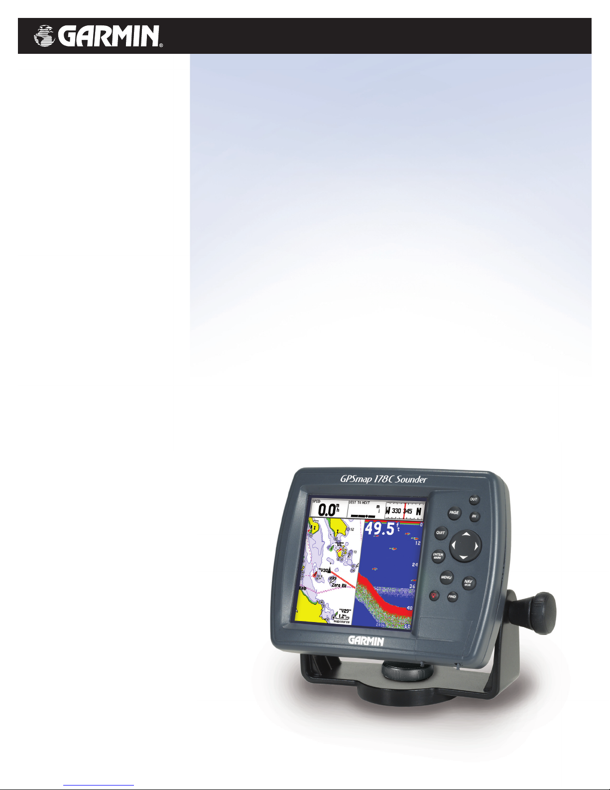
GPSMAP®172/172C and 178/178C
Brilliant color or value-priced grayscale.
Either choice leads to great navigation
performance with Garmin’s newest GPS
chartplotters: the GPSMAP
®
172/172C
and GPSMAP
®
178/178C Sounder. These
rugged, waterproof, fixed-mount units
pack a boatload of wayfaring features
into sleek, space-saving formats. Bright,
sunlight-readable 4.5-inch LCD screens
offer outstanding clarity and detail –
while 200-MHz processors ensure
lightning-quick panning, zoom and map
redraw rates. The Sounder version
GPSMAP 178/178C adds powerful sonar
capabilities to the mix, leaving fish
nowhere to hide. And preprogrammed
or user-programmed data cartridges can
be used to enhance the plotters’ built-in
basemaps with detailed BlueChart
®
marine cartography.
Chart your course with GPS to navigate with confidence.
©
2004
Garmin Ltd. or its subsidiaries
Garmin International, Inc.
1200 East 151st Street
Olathe, Kansas 66062, U.S.A.
913/397.8200 fax 913/397.8282
Garmin (Europe) Ltd.
Unit 5, The Quadrangle
Abbey Park Industrial Estate
Romsey, SO51 9DL, U.K.
44/1794.519944 fax 44/1794.519222
Garmin Corporation
No. 68, Jangshu 2nd Rd.
Shijr, Taipei County, Taiwan
886/2.2642.9199 fax 886/2.2642.9099
www.garmin.com
Specifications are preliminary and subject to change
without notice.
Navigation features
Waypoints/icons: 3,000 waypoints with name, symbol,
depth and water symbols, 10 proximity
Routes: 50 reversible routes with up to 50 points
each, plus MOB and TracBack®modes
Tracks: 10,000 point automatic track log; 15
saved tracks (up to 700 track points each)
let you retrace your path in both directions
Trip computer: Trip odometer, stopped time, moving
average, moving time, total average,
total time, maximum speed, odometer
Alarms: Anchor drag, arrival, off-course,
proximity waypoint and clock
Tables: Built-in celestial tables for sun and moon
by date and position
Tides: Tide data (U.S.A. only)
Map datums: More than 106 including user datum
Position format: Lat/Lon, UTM/UPS, Maidenhead, MGRS,
Loran TDs and other grids
DSC Support: Yes
GPS performance
Receiver: WAAS enabled, 12 parallel channel GPS
receiver continuously tracks and uses up
to 12 satellites to compute and update
your position
Acquisition times:
Warm: Approximately 15 seconds
Cold: Approximately 45 seconds
AutoLocate™: Approximately 5 minutes
Update rate: 1/second, continuous
GPS accuracy:
Position: < 15 meters,(49 feet) 95% typical
Velocity: 0.05 meter/sec steady state
Interfaces: NMEA 0183 (2 inputs), RTCM 104 DGPS
corrections and outputs
Antenna: Choice of
Internal or External QuadHelix
(GA 29 remote marine mount
with 30’ cable)
Plotter/moving map features
Basemap: Built-in Worldwide Marine basemap to
32 nm with coastlines, rivers, lakes,
political boundaries, tide data for the U.S.,
cities, interstates, U.S. state highways and
major thoroughfares
Uploadable maps: Accepts preprogrammed or
user-programmed Garmin data cards
containing optional MapSource
cartography
Plotting scales: 20 feet to 800 nm with dedicated
push-button zoom control
Power
Source: 10-35 vDC
Usage: GPSMAP 172C/172 = 6 watts
GPSMAP 178C/178 sounder = 14 watts
Physical
Size: 4.9”H x 6.3”W x 2.8”D
(122.5 x 157.5 x 71 mm)
Weight: 172C/172 = 1 lb. 1 oz.
178C/178 = 1 lb. 3.5 oz.
Display: 3.2" W x 3.2" H, 320 x 320 pixels
with adjustable CCFL backlighting
172C/178C = 256 color CSTN
172/178 = 10-level FSTN
Case: Fully gasketed, high impact plastic alloy,
waterproof to IEC 60529 IPX7 standards
Temperature range: 5ºF to 131ºF (-15ºC to 50ºC)
User data storage: Internal backup of user settings,
no memory battery required
Accessories
Standard: Chartplotting receiver
Remote antenna with 30’ cable
or internal antenna
Power/data cable
User’s manual
Single-knob tilt & swivel bracket
Quick start guide
Unit cover
Various transducers (178/178C only)
Optional: Compatible with most Garmin
MapSource
®
products, including
Recreational Lakes with Fishing Hot
Spots®, BlueChart®, Recreational Lakes
with Fishing Hot Spots®, Topo. (Garmin
data cartridges required)
GPSMAP 172/172C chartplotter is
compatible with optional GSD 20 remote
module to add full Sounder capabilities
Depth Sounder features (GPSMAP 178/178C Sounder only)
Frequency: 50/200 kHz or 200 kHz
Transmit power: 500 watts (RMS), 4000 watts (peak-to-
peak) w/ dual frequency transducer
400 watts (RMS), 3200 watts (peak-topeak) w/ single frequency transducer
Performance features: Depth Control Gain (DCG®) for detailed
bottom and structure views; adjustable
range, gain and zoom; 3-level fish ID;
graphic whiteline provides clear image of
bottom hardness and structure; See-Thru
®
technology separates fish returns from
thermoclines and structure
Alarms: Shallow water, fish by size, anchor drift,
timer, temperature, and low battery
voltage
Transducers: Choice of single or dual frequency
transom-mount transducers. Also
available without transducer
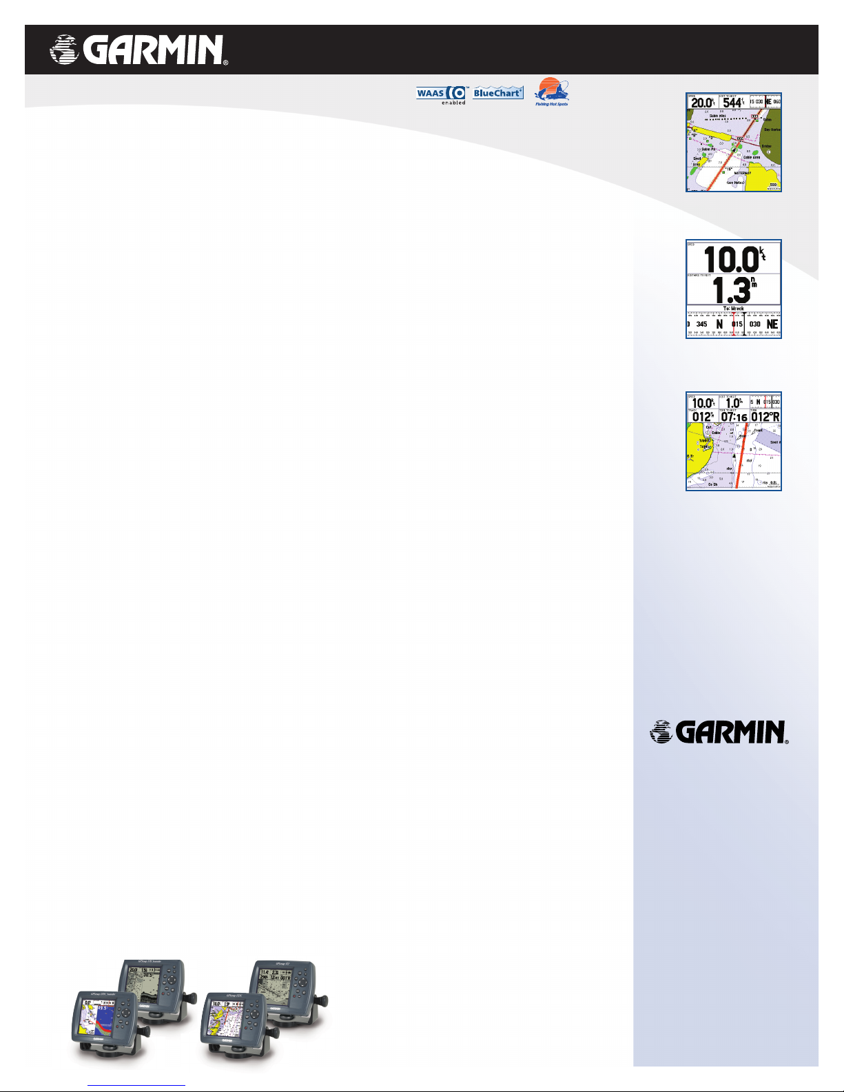
Map Page
Data cartridges provide optional MapSource
data for enhanced map detail
Navigation page
Shows distance, speed and direction to
waypoint, helping you stay on course
Big Numbers Option
Enlarge size of data fields to make them
readable from a distance
GPSMAP®172/172C and 178/178C
1104 M01-10157-00
compatible
 Loading...