

Garmin 02865 Users Manual

model: 660
Draft
™
Quick Reference Guide

Copyright © 2015 Garmin Ltd. or its subsidiaries. All rights reserved.
Draft
This manual reflects the operation of System Software version 1.0 or later. Some differences in
operation may be observed when comparing the information in this manual to earlier or later
software versions.
Garmin International, Inc., 1200 East 151st Street, Olathe, Kansas 66062, U.S.A.
Tel: 913/397.8200 Fax: 913/397.8282
Garmin AT, Inc., 2345 Turner Road SE, Salem, OR 97302, U.S.A.
Tel: 503/391.3411 Fax 503/364.2138
Garmin (Europe) Ltd, Liberty House, Bulls Copse Road, Hounsdown Business Park,
Southampton, SO40 9RB, U.K.
Tel: 44/0370.8501243 Fax: 44/0870.8501251
Garmin Corporation, No. 68, Jangshu 2nd Road, Shijr, Taipei County, Taiwan
Tel: 886/02.2642.9199 Fax: 886/02.2642.9099
Web Site Address: www.garmin.com
Except as expressly provided herein, no part of this manual may be reproduced, copied, transmitted,
disseminated, downloaded or stored in any storage medium, for any purpose without the express
written permission of Garmin. Garmin hereby grants permission to download a single copy of this
manual and of any revision to this manual onto a hard drive or other electronic storage medium to
be viewed for personal use, provided that such electronic or printed copy of this manual or revision
must contain the complete text of this copyright notice and provided further that any unauthorized
commercial distribution of this manual or any revision hereto is strictly prohibited.
®
, FliteCharts®, SafeTaxi®, and MapSource® are registered trademarks of Garmin Ltd. or its
Garmin
subsidiaries. aera™ is a trademark of Garmin Ltd. or its subsidiaries. These trademarks may not be
used without the express permission of Garmin.
Jeppesen® is a registered trademark of Jeppesen, Inc.
™
NavData
SiriusXM
AC-U-KWIK
November, 2015 190-02017-10 Rev. A Printed in the United States or Taiwan
is a trademark of Jeppesen, Inc.
®
is a registered trademark of SiriusXM Satellite Radio, Inc.
®
is a registered trademark of Penton Business Media, Inc.

Overview
Draft
SECTION 1 OVERVIEW
1.1 UNIT OVERVIEW
The purpose of this document is to provide a resource with which to find operating
instructions on the major features of the aera 660 quickly and easily. This Quick
Reference Guide is not intended to be a comprehensive operating guide. Refer to the
aera 660 Pilot’s Guide for complete operating procedures and warnings.
Power Button
External Antenna Connector
USB Connector
Micro SD Card Slot
Overview GPS Navigation Flight Planning Hazard Avoidance Utilities Appendix Index
USB Ports
Power Button
Unit Overview
190-02017-10 Rev. A
Garmin aera 660 Quick Reference Guide
1
Overview
Draft
1.2 GETTING STARTED
OverviewGPS NavigationFlight PlanningHazard AvoidanceUtilitiesAppendixIndex
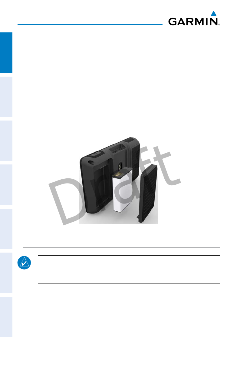
BATTERY INSTALLATION
Installing the battery:
1)
Locate the lithium-ion battery that came in the product box.
2)
Locate the metal contacts on the end of the lithium-ion battery.
3)
Insert the battery so that the metal contacts on the battery line-up with the
metal contacts inside the battery compartment.
4)
Insert the battery into the battery compartment, and push until it clicks into
place.
Unit Overview - Battery
CHARGING THE BATTERY
NOTE: While in Charge Mode, the unit draws a current from the aircraft. To
avoid discharging the aircraft’s battery, disconnect the external power cable
from the unit when not in use for several days.
Charging the unit’s battery using the aircraft's power outlet:
1)
Mount the aera 660 in the aircraft and connect the power cable to the
aircraft power outlet (cigarette lighter receptacle).
2)
Route the power cable so that it does not interfere with aircraft operation.
The unit begins charging as soon as external power is applied.
2
Garmin aera 660 Quick Reference Guide
190-02017-10 Rev. A
Overview
Draft
GPS RECEIVER STATUS
The bars located at the top of the screen indicate the GPS signal strength.
Viewing the GPS status:
From the Main Menu, touch Info > Satellite Status
tab
.
DISPLAY ORIENTATION
The aera 660 can be viewed in either Portrait or Landscape Mode.
Changing the display orientation:
1)
From the Main Menu, touch Tools > Setup > Display
Or
:
Press the Power Button once quickly.
1.3 OPERATION
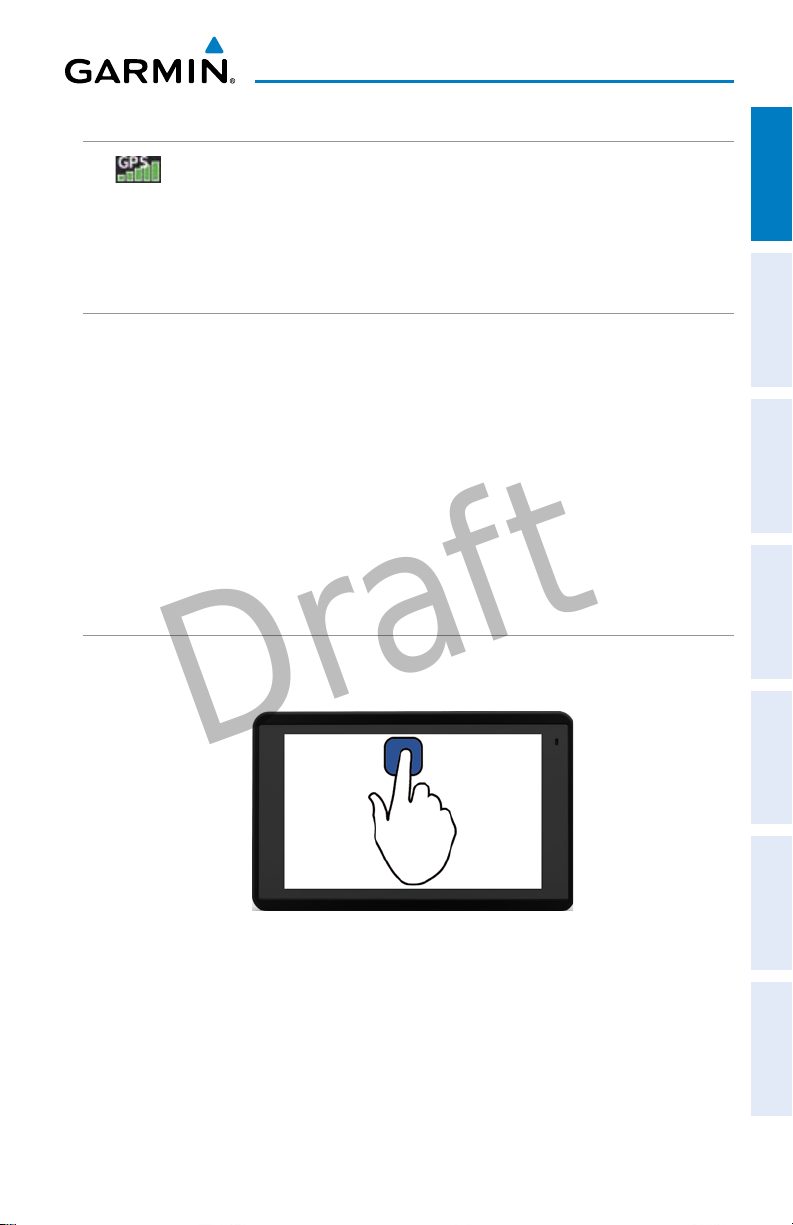
BASIC TOUCHSCREEN OPERATION
Touch the desired selection. The icon, menu option, etc., will momentarily
turn blue when selected.
Overview GPS Navigation Flight Planning Hazard Avoidance Utilities Appendix Index
Basic Touchscreen Operation
190-02017-10 Rev. A
Garmin aera 660 Quick Reference Guide
3
Overview
Draft
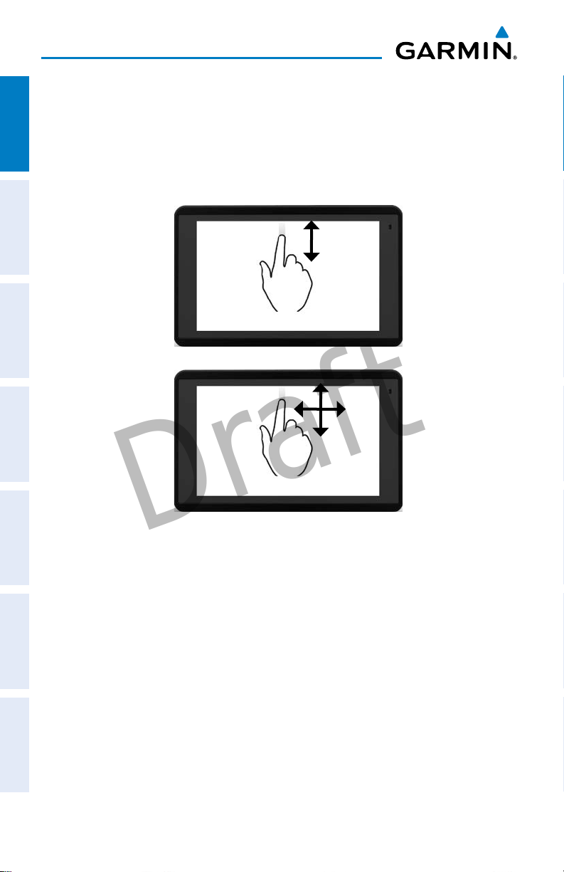
SCROLLING AND PANNING
Scrolling and panning on the touchscreen:
OverviewGPS NavigationFlight PlanningHazard AvoidanceUtilitiesAppendixIndex
Drag up or down to scroll menus, documents, etc.
Or:
Drag in any direction to pan maps or charts.
Scroll
Pan
4
Garmin aera 660 Quick Reference Guide
190-02017-10 Rev. A
Overview
Draft
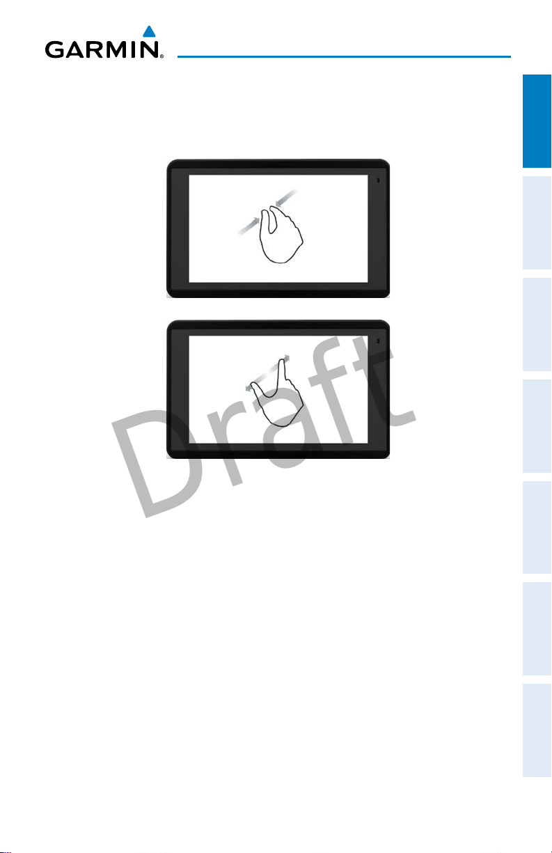
ZOOMING
Zooming in and out on the touchscreen map displays:
Pinch fingers together (zoom out), or pull fingers apart (zoom in).
Zoom In
Zoom Out
Overview GPS Navigation Flight Planning Hazard Avoidance Utilities Appendix Index
190-02017-10 Rev. A
Garmin aera 660 Quick Reference Guide
5
Overview
Draft
DEDICATED PAGE ICONS
Dedicated Page Icons are located vertically on the right side of the screen in
OverviewGPS NavigationFlight PlanningHazard AvoidanceUtilitiesAppendixIndex
landscape mode or horizontally along the bottom of the screen in portrait mode.
Dedicated
Page Icons
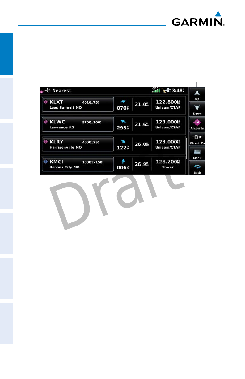
Nearest Airports Page
6
Garmin aera 660 Quick Reference Guide
190-02017-10 Rev. A

Overview
Draft
Scroll up OR
Scroll down OR
Nearest Group Icons
(Nearest Page Only)
Direct-to function.
Page menu
OR
OR
Returns to previous
screen.
Touch and hold to
display the Main Menu.
Weather Group Icons
(Weather Page Only)
Overview GPS Navigation Flight Planning Hazard Avoidance Utilities Appendix Index
• Previous Screen
• Main Menu (Touch
and Hold)
190-02017-10 Rev. A
Garmin aera 660 Quick Reference Guide
OR
Cancel map pointer
7
Overview
Draft
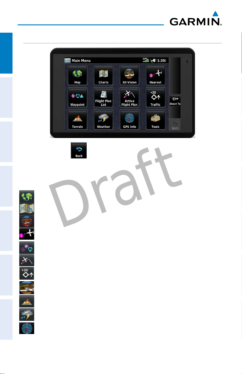
MAIN MENU
OverviewGPS NavigationFlight PlanningHazard AvoidanceUtilitiesAppendixIndex
Touch and hold the
MAIN MENU ICONS
Touch the following icons to display the associated page or menu:
Map Displays the Map View.
Charts Displays the VFR or IFR charts.
3D Vision Displays 3D Vision.
Nearest Displays the Nearest Page
Waypoint Displays the Waypoint Information.
Active Flight Plan Displays the Active Flight Plan.
Traffic Displays the dedicated Traffic Page.
3D Vision Displays 3D Vision Page
Terrain Displays the Terrain View.
Weather
GPS Info Displays current position, satellite status, and data fields.
icon at any time to display the Main Menu.
Displays second-level Weather Icons
8
Garmin aera 660 Quick Reference Guide
190-02017-10 Rev. A
Overview
Draft
Tools Displays second-level Tools Icons.
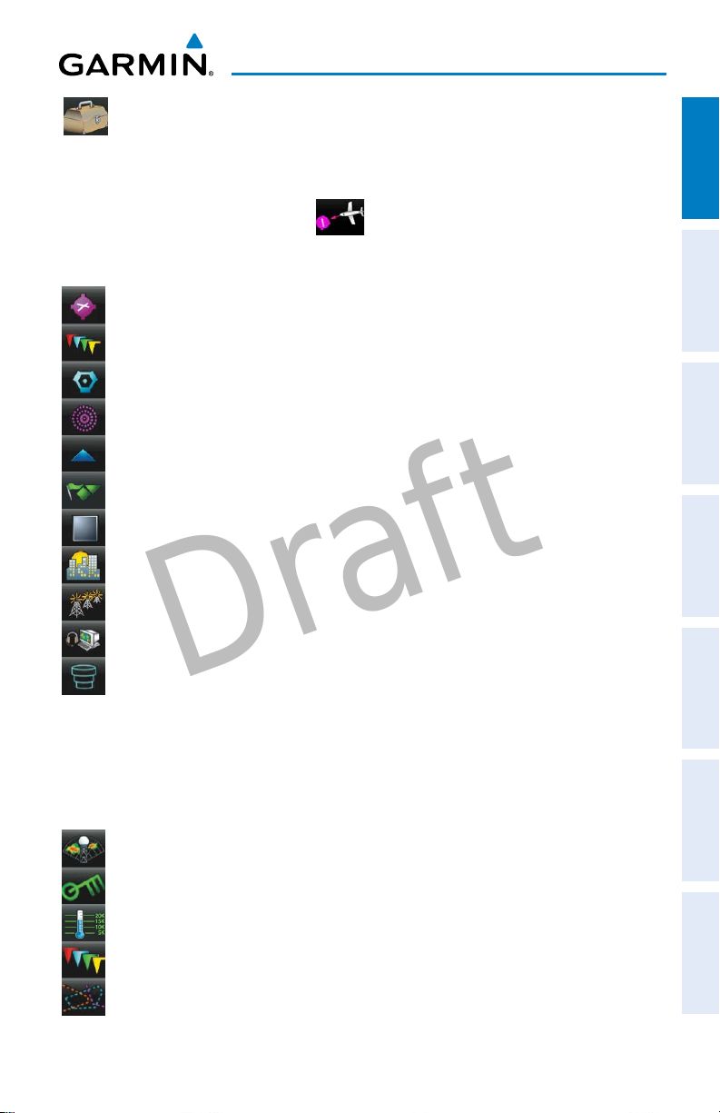
NEAREST ICONS
From the Main Menu, touch the
Touch the following Nearest Group Icons to display the associated function:
Airport Displays nearest airports.
Airport WX Displays nearest airport weather.
VOR Displays nearest VORs.
NDB Displays nearest NDBs.
Intersection Displays nearest intersections.
VRP Displays nearest Visual Reporting Point (VRP) (Atlantic).
User WPT Displays nearest user waypoints.
City Displays nearest cities.
ARTCC Displays nearest ARTCCs (Air Route Traffic Control Centers).
FSS Displays nearest Flight Service Stations (FSS).
icon to access the Nearest Page.
Overview GPS Navigation Flight Planning Hazard Avoidance Utilities Appendix Index
Airspace Displays nearest airspace.
WEATHER ICONS (GDL 39)
From the Main Menu, touch the Weather icon to access the Weather Page.
Touch the following Weather Group Icons to display the weather product:
NEXRAD Radar Displays NEXRAD (NEXt-generation RADar).
Winds Aloft Displays Winds Aloft.
Temps Aloft Displays Temperatures Aloft.
METAR Displays METARs.
AIRMET Displays AIRMETs.
190-02017-10 Rev. A
Garmin aera 660 Quick Reference Guide
9

Overview
Draft
SIGMET Displays SIGMETs.
TFR Displays TFRs.
OverviewGPS NavigationFlight PlanningHazard AvoidanceUtilitiesAppendixIndex
Pilot Reports Displays PIREPs.
TOOLS
From the Main Menu, touch the Tools Icon to access the second-level Tools icons.
Touch the following second-level icons to display the associated function:
Setup Displays third-level Setup Icons.
User WPT Displays User Waypoints and Proximity Waypoints.
Flight Log Displays Flight Logs.
Track Log Displays Track Logs.
FPL List Displays the Flight Plan List.
VNAV Displays Vertical Navigation.
Profile Displays Aircraft Profiles.
E6B Displays the E6B Calculator.
Weight/Bal Displays the Weight & Balance.
Data Link Displays Data Link Information.
User Timer Displays User Timer.
Database Displays database and software version information.
VIRB Displays VIRB Remote Page.
10
Garmin aera 660 Quick Reference Guide
190-02017-10 Rev. A
Overview
Draft
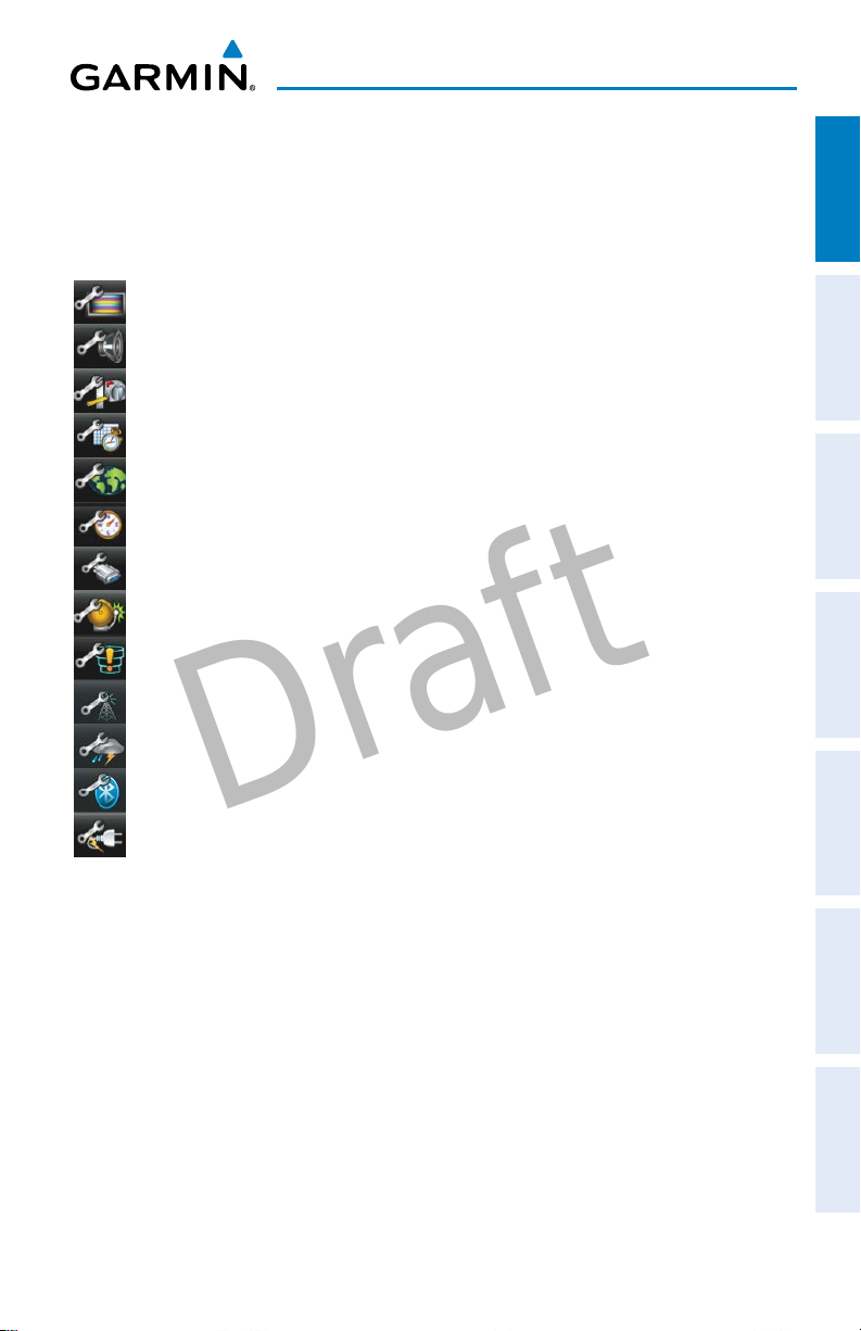
Setup IconS
From the Main Menu, touch the Tools > Setup to access the third-level Setup
Icons.
Touch the following third-level icons to perform the associated function:
Display Displays backlight intensity/timeout and color mode settings.
Sound Displays sound settings.
Units Displays unit settings.
Time Displays time settings.
Map Displays Navigation Map settings.
Position Displays position settings.
Interface Displays interface settings.
Alarms Displays alarm settings.
Airspace Displays Special Use Airspace alarm settings.
Data Link Displays Data Link Information.
Weather Displays Weather source settings.
Overview GPS Navigation Flight Planning Hazard Avoidance Utilities Appendix Index
Bluetooth®Displays Bluetooth connection settings
Power Displays Power Loss Warning settings.
190-02017-10 Rev. A
Garmin aera 660 Quick Reference Guide
11

Overview
Draft
BLUETOOTH
Connecting/Pairing GDL 39 via Bluetooth:
OverviewGPS NavigationFlight PlanningHazard AvoidanceUtilitiesAppendixIndex
1)
From the Main Menu, touch Tools > Setup > Bluetooth.
2)
Ensure the Bluetooth on the GDL 39 is in Pairing Mode. Press and hold the
power button on the GDL 39 to enter pairing mode (the blue LED will flash
on the GDL 39 when in pairing mode).
3)
Touch On.
4)
Touch Not Paired next to the GDL Device. A Bluetooth Passkey window
with open.
5)
Touch OK. The GDL 39 is now connected.
®
20
Garmin aera 660 Quick Reference Guide
190-02017-10 Rev. A

Appendix
Draft
LICENSE AGREEMENT AND WARRANTY
CONTACT GARMIN
OverviewGPS NavigationFlight PlanningHazard AvoidanceUtilitiesAppendixIndex
Contact Garmin if you have any questions while using your aera 660. In the USA, contact Garmin Product
Support by phone: (913) 397-8200 or (866) 739-5687, Monday–Friday, 7 AM–7 PM Central Time; or go to https://
fly.garmin.com/fly-garmin/support.
In Europe, contact Garmin (Europe) Ltd. at +44 (0) 870.8501241 (outside the UK) or 0808 2380000 (within
the UK).
SOFTWARE LICENSE AGREEMENT
BY USING THE aera 660, YOU AGREE TO BE BOUND BY THE TERMS AND CONDITIONS OF THE FOLLOWING
SOFTWARE LICENSE AGREEMENT. PLEASE READ THIS AGREEMENT CAREFULLY.
Garmin grants you a limited license to use the software embedded in this device (the “Software”) in binary
executable form in the normal operation of the product. Title, ownership rights, and intellectual property rights in
and to the Software remain with Garmin.
You acknowledge that the Software is the property of Garmin and is protected under the United States of America
copyright laws and international copyright treaties. You further acknowledge that the structure, organization, and
code of the Software are valuable trade secrets of Garmin and that the Software in source code form remains
a valuable trade secret of Garmin. You agree not to decompile, disassemble, modify, reverse assemble, reverse
engineer, or reduce to human readable form the Software or any part thereof or create any derivative works
based on the Software. You agree not to export or re-export the Software to any country in violation of the export
control laws of the United States of America.
LIMITED WARRANTY
This Garmin product is warranted to be free from defects in materials or workmanship for one year from the
date of purchase. Within this period, Garmin will, at its sole option, repair or replace any components that fail in
normal use. Such repairs or replacement will be made at no charge to the customer for parts or labor, provided
that the customer shall be responsible for any transportation cost. This warranty does not cover failures due to
abuse, misuse, accident, or unauthorized alteration or repairs. In addition, Garmin reserves the right to refuse
warranty claims against products or services that are obtained and/or used in contravention of the laws of any
country.
This product is intended to be used only as a travel aid and must not be used for any purpose requiring precise
measurement of direction, distance, location, or topography. Garmin makes no warranty as to the accuracy or
completeness of map data in this product.
THE WARRANTIES AND REMEDIES CONTAINED HEREIN ARE EXCLUSIVE AND IN LIEU OF ALL OTHER
WARRANTIES EXPRESS, IMPLIED, OR STATUTORY, INCLUDING ANY LIABILITY ARISING UNDER ANY WARRANTY
OF MERCHANTABILITY OR FITNESS FOR A PARTICULAR PURPOSE, STATUTORY OR OTHERWISE. THIS WARRANTY
GIVES YOU SPECIFIC LEGAL RIGHTS, WHICH MAY VARY FROM STATE TO STATE.
IN NO EVENT SHALL GARMIN BE LIABLE FOR ANY INCIDENTAL, SPECIAL, INDIRECT, OR CONSEQUENTIAL
DAMAGES, WHETHER RESULTING FROM THE USE, MISUSE, OR INABILITY TO USE THIS PRODUCT OR FROM
DEFECTS IN THE PRODUCT. SOME STATES DO NOT ALLOW THE EXCLUSION OF INCIDENTAL OR CONSEQUENTIAL
DAMAGES, SO THE ABOVE LIMITATIONS MAY NOT APPLY TO YOU.
46
Garmin aera 660 Quick Reference Guide
190-02017-10 Rev. A
 Loading...