

Page 1
www.vaisala.com
Vaisala Road Weather Navigator WID721
Benefits
User-friendly
▪
Provides valuable weather
▪
information for decisionmaking
Monitor trouble spots/known
▪
problem areas
Allows you to make quicker
▪
decisions
Customized software means
▪
users will readily accept the
technology
Keeps you from getting caught
▪
o-guard
Features
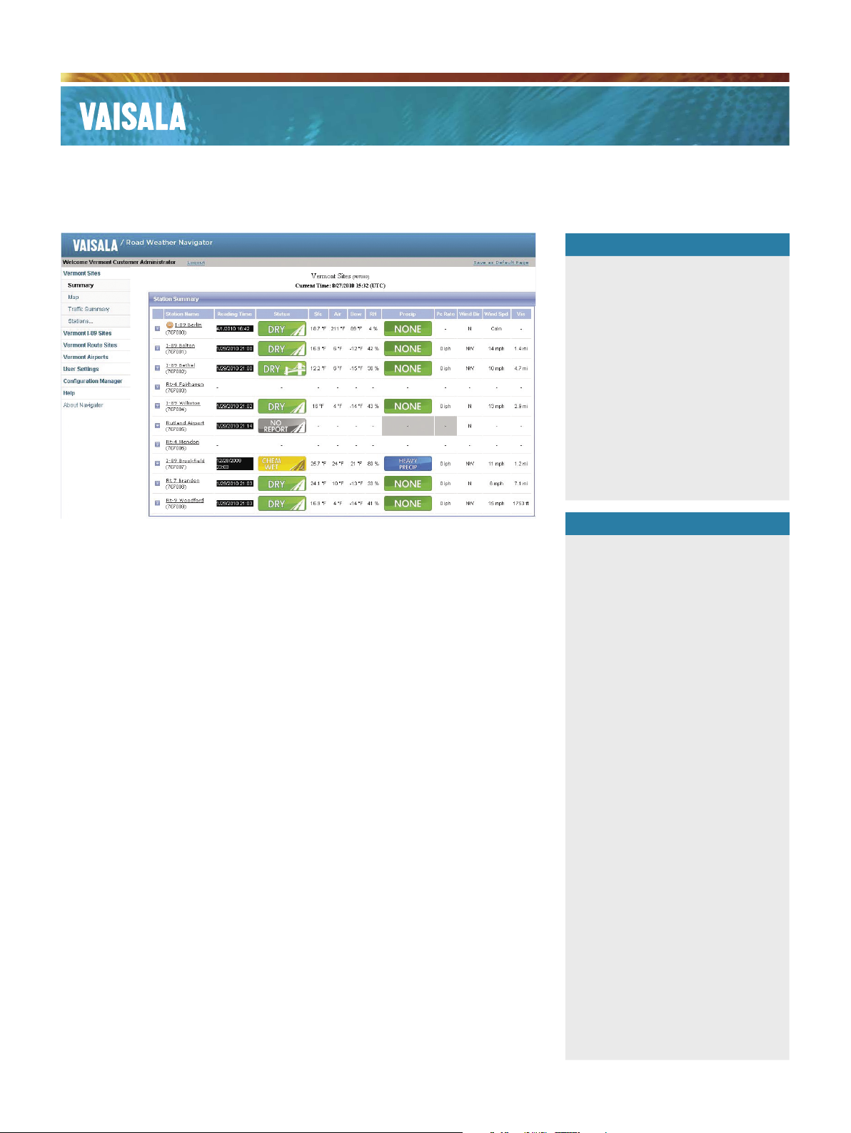
Displays current and historical
Overview
Vaisala Road Weather Navigator
WID721 is a unique user interface
designed to give RWIS (Road/Runway
Weather Information System) users
more control over how their data
is viewed, which allows for quick
analysis and decision-making during
weather events. RWIS collects vital
information from pavement, weather
and trafc sensors, and viewing your
RWIS data is just as important as
the system collecting it. With Vaisala
Navigator RWIS data is displayed in a
simple, user-friendly manner, which
makes it easy to learn and navigate.
Navigator provides an unparalleled
level of user customization, allowing
you to personalize map views, data
sets, user groups, etc. and create
warning notications based on your
pre-dened parameters.
Viewing RWIS data quickly and easily
enables maintenance and operations
personnel to monitor changing
weather conditions in real time and
make informed and timely decisions.
Two options are available for Vaisala
Navigator. A hosted version where
Vaisala gathers data from the RWIS
sites directly and users can access
anywhere they have internet access.
A second version the customer
hosts the data and manages the data
collection equipment.
▪
RWIS data
Customize displays – home
▪
page, maps, units of measure,
and more
Administrative control for
▪
adding users, managing
groups, editing station maps
and site configurations, etc.
Interactive map allows you to
▪
view all RWIS data at once,
it updates automatically and
displays sites under warning
Easy to read tabular views
▪
– summary page displays
conditions clearly with the
ability to drill down to each site
level
Capable of displaying trac
▪
data from in-pavement or
roadside sensors and/or air
quality data
Capable of displaying live
▪
streaming video images
Alarm/alert notification
▪
for user-defined weather
parameters
Reacts quickly to data requests
▪
or camera images (pages
download quickly)
Page 2

Technical Data
Vaisala Road Weather Navigator
CUSTOMER MANAGED SOLUTION:
Used with a customer-owned server where administrative
functions are managed by the customer (upgrades, security,
communication, etc.)
Reliable software capable of handling large amounts of data
(ideal for large RWIS networks with one or more servers
Larger storage capacity for historical data (length of data storage
depends on number of site and interval of data collection)
VAISALA HOSTED SOLUTION:
Hosted server option where Vaisala hosts your RWIS data
A hosted server saves cost and eliminates issues with network
system administration about security, firewall limitations,
or other IT concerns
Data is viewed using a password protected web site and can be
viewed from work or home
Ability to participate in a data sharing network with other agencies
using RWIS online Navigator
Communication costs can be included as an option
Regular system status reports prepared by the Vaisala Service Team
Applications
Departments of Transportation or agencies with
▪
large RWIS networks
City/County street departments with just a few
▪
RWIS sites
Airports
▪
Agencies or airports requiring a web-hosted data
▪
solution
For more information, visit
www.vaisala.com or contact
us at sales@vaisala.com
Ref. B211038EN-A ©Vaisala 2010
This material is subject to copyright protection, with all
copyrights retained by Vaisala and its individual partners. All
rights reserved. Any logos and/or product names are trademarks
of Vaisala or its individual partners. The reproduction, transfer,
distribution or storage of information contained in this brochure
in any form without the prior written consent of Vaisala is strictly
prohibited. All specifications — technical included — are subject
to change without notice.
 Loading...