

Page 1

TomTom navigation
module
Page 2
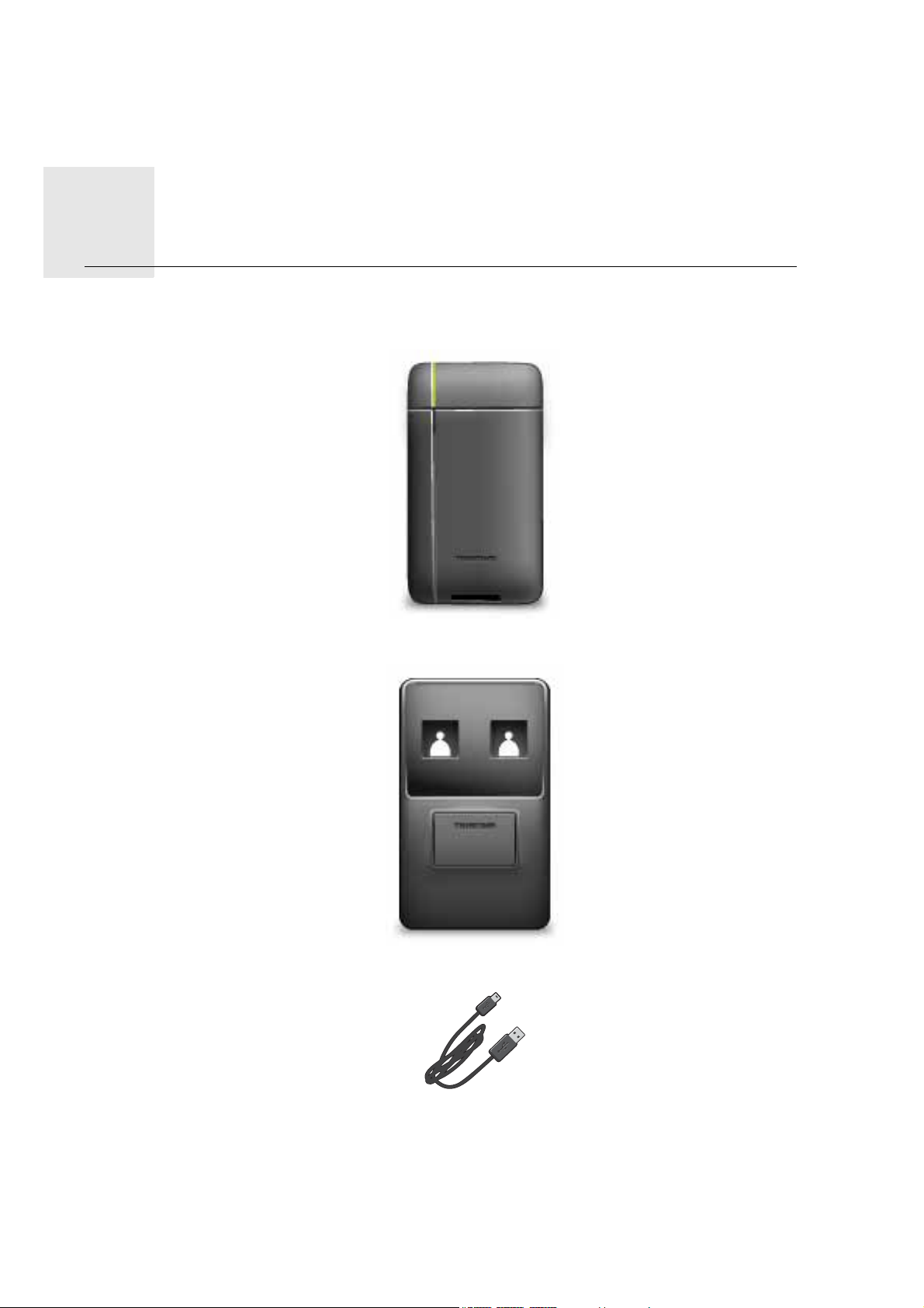
What’s in the box1.
What’s
in the
box • TomTom navigation module
• Car dock
•USB cable
•MyTomTom leaflet
2
Page 3

Read me first2.
Read me first
Car dock
Push your TomTom navigation module into the car dock in your car. To remove your navigation module from the car dock, press the release button on the car dock. Your dealer
can install the car dock and connect it to the Sony XNV.
The display of the Sony XNV is also used as the navigation module display. Use the Sony
XNV touch screen to operate your navigation module.
Switching on and off
The TomTom navigation module switches on simultaneously with the Sony XNV. Select
Navi in the main menu of the Sony XNV.
Until a connection has been established between the Sony XNV and the navigation module, "waiting for Navi connection" is displayed. In the case of a cold boot of the navigation
module,the start-up image of the module is visible as soon as a connection has been
established.
Under extreme temperature conditions or if the battery of the navigation module is empty,
a warning screen will be displayed. The module will start-up as soon as the battery temperature is within specifications and the battery is charged sufficiently.
Setting up
Important: Take care to select the correct language, since the language you choose will
be used for all menus and written instructions.
When you first switch on your device, you have to answer a few questions to set up the
device. Answer the questions by tapping the screen.
GPS reception
When you first start your TomTom navigation module, the device may need a few minutes
to determine your GPS position and show your current position on the map. In future, your
position will be found much faster, usually within a few seconds.
To ensure good GPS reception, you should use your device outdoors. Large objects such
as tall buildings can sometimes interfere with reception.
About MyTomTom
MyTomTom helps you manage the contents and services of your TomTom navigation
module, as well as giving you access to the TomTom community. You log in to MyTomTom on the TomTom website. It is a good idea to frequently connect your navigation module to MyTomTom, to ensure you always have the latest updates.
3
Page 4

Tip: We recommend using a broadband internet connection whenever you connect your
navigation device to MyTomTom.
Setting up MyTomTom
1
1
1
2
2
2
To set up MyTomTom, do the following:
1. Connect your computer to the internet.
2. Start a browser and go to tomtom.com/getstarted.
3. Click Download now.
Your browser downloads the MyTomTom support application, which you need to
install on your computer in order to connect your device to MyTomTom. Follow the
instructions on the screen if you are asked questions while downloading.
4. Connect your device to your computer using the USB cable.
Your device is then recognised, and possible updates are offered.
Important: You should plug the USB connector directly into a USB port on your computer
and not into a USB hub or USB port on a keyboard or monitor.
Once the MyTomTom support application is installed on your computer, you can access
MyTomTom from the system tray on your computer.
Tip: When you connect your navigation device to your computer, MyTomTom tells you if
there are any updates for your device.
Device not starting
In rare cases, your TomTom navigation module may not start correctly or may stop
responding to your taps.
The battery may not be charged enough. The battery charges when the navigation module
is docked in the car dock and the Sony XNV is powered, or when the module is connected
to the computer. The screen shows a warning if there is a problem with the battery.
The battery temperature may be too high or too low. Also in this case the screen shows a
warning. The navigation module will start-up if the battery temperature is within the specifications.
If the battery is charged but navigation is still not available, you may need to reset the navigation module. To reset your navigation module, first remove it from the car dock by
pressing the release button. Then press the reset button on the back of the navigation
module for at least 10 seconds. Push the navigation module back into the car dock.
4
Page 5

Charging your TomTom navigation module
The LED on the navigation module is red while the battery is charging, and is green when
it is fully charged.
Important: You should plug the USB connector directly into a USB port on your computer
and not into a USB hub or USB port on a keyboard or monitor.
Safety Notice
Your TomTom navigation module contains a GSM/GPRS module which can interfere with
electrical devices such as cardiac pacemakers, hearing aids and aviation equipment.
Interference with these devices may endanger the health or life of you or others, so in
these cases remove your TomTom navigation module from the car dock.
As your TomTom navigation module includes a GSM/GPRS module, do not use it near
unprotected electrical units or in areas where the use of mobile telephones is prohibited,
such as hospitals and airplanes.
Take care of your navigation device
Never leave your TomTom navigation module or accessories on view when you leave the
car as they may become an easy target for thieves.
It is important to take care of your device:
• Your device is not designed for use in extreme temperatures and any such exposure
may cause permanent damage. Extended exposure to sun light may lead to early deterioration in battery performance.
• Do not open the casing of your device under any circumstances. Doing so may be dangerous and will invalidate the warranty.
5
Page 6

Safety3.
Safety
Safety settings
We recommend using the safety settings to make your driving as safe as possible.
These are some of the options included in the safety settings:
• Show essential menu buttons while driving
• Show safety reminders
• Warn when driving faster than allowed
6
Page 7

Planning a route4.
Planning a
route Important: In the interest of safety and to reduce distractions while you are driving, you
should always plan a route before you start driving.
To plan a route on your TomTom navigation module, do the following:
1. Tap the screen to open the Main menu.
2. Tap Navigate to...
3. Tap Address.
Tip: The first time you plan a route, you are asked to select a country, state or region. Your
selection is saved and used for all future routes until you change this setting.
You can change this setting by tapping the flag before you select a city.
4. Enter the town or city name.
• Towns with similar names are shown in the list while you type.
• When the correct city or town appears in the list, tap the name to select the destina-
tion.
5. Enter the streetname.
• Streets with similar names are shown in the list while you type.
7
Page 8

• When the correct streetname appears in the list, tap the name to select the destina-
tion.
6. Enter the house number, then tap Done.
7. The location is shown on the map. Tap Select to continue or tap Back to enter another
address.
Tip: If you want your final destination to be a car park, tap Car park and select a location
from the list of car parks close to your general destination.
8. Select the type of route you want to plan.
8
Page 9

9. When the new route is shown, tap Done.
• For more information about the route, tap Details.
• To plan a different route, tap Change route.
Your TomTom navigation module starts to guide you to your destination, using spoken
instructions and onscreen directions.
Route summary
The route summary shows an overview of your route, the remaining distance to your destination and the remaining estimated journey time.
To view the route summary, tap the right-hand panel on the status bar in the Driving view
or tap View route in the Main menu and then tap Show route summary.
When used with TomTom Traffic, the route summary shows an overview of your route,
the remaining distance to your destination, the remaining estimated journey time and traffic information about delays on your route.
LIVE summary
LIVE summary shows LIVE services information on your route.
To view LIVE summary information, tap the LIVE tab on the route summary screen. Tap
any of the panels for more detailed information.
9
Page 10

The LIVE tab panels show the following information:
• Traffic on route - tap this panel to view detailed information about traffic delays and
other incidents on your route.
• Speed cameras - tap this panel to open the Speed Camera menu. You can then report
a speed camera or change your settings for speed camera warnings.
• Weather - tap this panel to view the latest weather reports.
Note: Not all LIVE services are available in all countries. You may be able to use LIVE services when travelling abroad. For more information on available services, go to tom-
tom.com/services.
Frequent destinations
If you often make trips to the same destinations, you can set your TomTom navigation
module to ask if you want to plan a route to one of these locations, every time the device
starts. This is faster than planning a route in the normal way.
To select a new destination, tap Start-up settings in the Settings menu and select Ask for
a destination. Then select a button to use for this destination and answer the questions
about the destination.
Show my frequent destinations
You can set your TomTom navigation module to ask if you want to plan a route to one of
your frequently visited destinations every time the device starts.
To change this setting, do the following:
1. Tap Start-up settings in the Settings menu and then select Ask for a destination.
2. Tap Yes, then tap Yes again to begin entering information about the destination.
3. Select a symbol for the destination and tap Done to set the symbol, then tap Yes.
Tip: To add new destinations, select one of the numbered symbols and enter a name for
the new destination button.
4. Tap Yes and if required enter a new name, then tap Done.
5. Enter the address details in the same way you enter an address when planning a route,
then tap Done.
6. If you want to set more destinations, repeat the steps above. Otherwise, tap Done.
You are asked if you want to change the start-up image.
7. If you want to change the image, tap Yes then follow the instructions shown on the
screen. Otherwise, tap No.
10
Page 11

Every time your TomTom navigation module starts, you are asked if you want to plan a
route. If you tap Cancel, you are shown the Main Menu.
Using arrival times
When you plan a route, your TomTom navigation module asks you if you need to arrive
at a particular time.
Tap YES to enter a preferred arrival time.
Your navigation module calculates your arrival time and shows you whether you will
arrive on time.
You can also use this information to work out when you need to leave. If your navigation
module shows that you will arrive 30 minutes early, you can wait and leave in 30 minutes
time, rather than arrive early.
Your arrival time is constantly recalculated during your journey. The status bar shows
whether you will arrive on time or if you are going to be late, as shown below:
You will arrive 55 minutes before the arrival time you entered.
If the estimated arrival time is more than five minutes before the time
you entered, it is shown in green.
You will arrive 3 minutes before the arrival time you entered.
If the estimated arrival time is less than 5 minutes before the time
you entered, it is shown in yellow.
You will arrive 19 minutes late.
If the estimated arrival time is later than the time you entered, it is
shown in red.
Ta p Status bar settings in the Settings menu, to enable or disable
arrival time notifications.
Status bar
preferences
To enable arrival time notifications, select Leeway.
Navigation menu options
When you tap Navigate to..., you can set your destination in many ways, not just by entering the address. The other options are listed below:
Tap this button to use TomTom Local Search with Google to help you
find shops and businesses in and around your current location.
Local search
You can choose to search for shops and businesses near you, near
your destination, near any other destination or in a city.
Home
For example, if you are looking for a swimming pool near your current location, enter ’swimming pool’ and choose the best search
result.
Tap this button to navigate to your Home location.
You will probably use this button more than any other.
11
Page 12

Favourite
Address
Recent
destination
Point of Interest
Point on map
Tap this button to select a Favourite as your destination.
Tap this button to enter an address as your destination.
Tap this button to select your destination from a list of places you
have recently used as destinations.
Tap this button to navigate to a Point of Interest (POI).
Tap this button to select a point on the map as your destination using
the map browser.
Tap this button to enter a destination using latitude and longitude
values.
Latitude
Longitude
Tap this button to select your last recorded position, as your destination.
Position of last
stop
Planning a route in advance
You can use your TomTom navigation module to plan a route in advance, selecting your
starting point and your destination.
Here are some more reasons to plan a route in advance:
• Find out how long a journey is going to take before you start.
You can also compare journey times for the same route at different times of the day or
on different days of the week. Your navigation module uses IQ Routes when planning a
route. IQ Routes calculates routes based on the real average speeds measured on
roads.
• Study the route of a journey you are planning.
• Check a route for someone who is coming to visit you and then explain the route to
them in detail.
To plan a route in advance, follow these steps:
1. Tap the screen to bring up the Main menu.
2. Tap Plan route.
12
Page 13

This button is shown while there is no planned route on your navigation module.
Prepare route
3. Select the starting point for your journey in the same way that you would select your
destination.
4. Set the destination for your journey.
5. Choose the type of route that should be planned.
• Fastest route - the route which takes the least time.
• Eco route - the most fuel-efficient route for your journey.
• Shortest route - the shortest distance between the locations you set. This may not
be the quickest route, especially if the shortest route is through a town or city.
• Avoid motorways - a route which avoids motorways.
6. Choose the date and time that you will make the journey you are planning.
Your navigation module uses IQ Routes to work out the best possible route at that time.
This is useful to see how long a journey takes at different times of the day or on different
days of the week.
7. Your TomTom navigation module plans the route between the two locations you
selected.
Viewing route information
You can access these options for the route you last planned by tapping View route in the
Main Menu or the Details button on the route summary screen.
You can then select from the following options:
Tap this button for a list of all the turn instructions on the route.
This is very useful if you need to explain a route to someone else.
Show instruc-
tions
Tap this button to see an overview of the route using the map
browser.
Show map of
route
Tap this button to watch a demo of the journey. You can interrupt the
demo at any time by tapping the screen.
Show route
demo
Tap this button to open the route summary screen.
Show route
summary
13
Page 14

Show
destination
Show traffic on
route
Tap this button to see a preview of your destination.
You can navigate to a car park near your destination, and view any
available information about your destination, for example, the phone
number.
Tap this button to see all the traffic incidents on your route.
Note: Traffic information is not available in all countries or regions.
14
Page 15

Driving View5.
km
G
Driving View
About the Driving View
When your TomTom navigation module device starts for the first time, you are shown the
Driving View along with detailed information about your current position.
Tap the centre of the screen at any time to open the Main Menu.
You can choose the screen shown when you switch on your device by tapping Settings
in the Main Menu, then tapping Start-up settings.
The Driving View
ABCD E
Prins Hendrikkade
34
min
km
13:31
54
KM/H
60
MAX
F
1. Zoom button - tap the magnifying glass to show buttons for zooming in and out.
2. Quick menu - to enable the quick menu, tap Make your own menu in the Settings menu.
3. Your current position.
4. Road sign information or the next street name.
5. Traffic sidebar. Tap the sidebar to open the Traffic menu.
6. The time, your current speed and the speed limit, if known. To see the difference
between your preferred arrival time and your estimated arrival time, check the Leeway
checkbox in the Status bar settings.
Tap this part of the status bar to switch between a 3D map and a 2D map.
7. The name of the street you are on.
8. Navigation instruction for the road ahead and the distance to next instruction. If the second instruction is less than150m after the first instruction, you see it shown immediately
instead of the distance.
Tap this part of the status bar to repeat the last voice instruction and to change the volume. You can also tap here to mute the sound.
800
METRES
H
16:31
2:30
HRS
I
60
KM
15
Page 16

9. The remaining journey time, the remaining distance and your estimated arrival time.
Tap this part of the status bar to open the Route Summary screen.
To change the information shown in the status bar, tap Status bar in the Settings menu.
Driving View symbols
The following symbols are shown in the Driving View:
EPT - this symbol is shown when your device is using tacho information to estimate your current location. EPT is only used when you
have no GPS reception.
Sound muted - this symbol is shown when the sound has been
muted.
To turn the sound back on, tap the middle panel in the status bar.
16
Page 17

Advanced Lane Guidance6.
Advanc
ed
Lane
About lane guidance
Guidance
Note: Lane guidance is not available for all junctions or in all countries.
Your TomTom navigation module helps you prepare for motorway exits and junctions by
showing the correct driving lane for your planned route.
As you approach an exit or junction, the lane you need is shown on the screen.
Using lane guidance
There are two types of lane guidance:
• Lane images
To turn lane images off, tap Settings in the Main Menu, then tap Advanced settings.
Clear the checkbox for Show lane images.
Tip: Tap anywhere on the screen to return to the Driving View.
• Instructions in the status bar
17
Page 18

Tip: If no lane guidance is shown in the status bar and all lanes are highlighted, you can
use any lane.
18
Page 19

Making changes to your route7.
Making
change
About route changes
s to
your
route
After you plan a route, you may want to change the route or even the destination. There
are various ways to change your route without the need to completely replan the entire
journey.
To change the current route, tap Change route in the Main menu:
Tap this button to change the current route.
This button is only shown while there is a planned route on your
Change route
Change route menu
To change the current route or your destination, tap one of the following buttons:
Calculate
alternative
navigation module.
Tap this button to find an alternative to the current route.
This button is only shown while there is a planned route on your
navigation module.
This is a simple way to search for a different route to your current
destination.
Avoid roadblock
Your navigation module calculates a new route from your current
location, to reach your destination using completely different roads.
The new route is shown next to the original route so that you can
select the route you want to use.
Tap this button while driving on a planned route, to avoid a roadblock or traffic congestion on the road ahead.
Your navigation module will suggest a new route which avoids the
roads on your current route for the selected distance.
If the roadblock or traffic congestion suddenly clears, tap Recalcu-
late route to replan your original route.
Important: Be aware that when a new route is calculated, you might
immediately be asked to turn off the current road.
19
Page 20

Minimise delays
Change
destination
Avoid part of
route
Tap this button to avoid traffic delays on a planned route.
It is not always possible to avoid all traffic delays. Your navigation
module will check for traffic delays on your route and calculate the
best route to avoid all or most of the delays.
Note: This button is only available when Traffic is enabled in the
LIVE services menu. For more information about TomTom traffic
information services, go to tomtom.com/services.
Tap this button to change the current destination.
When you change the destination, you are shown the same options
and asked to enter the new address in the same way as when you
plan a new route.
Tap this button to avoid part of the current route.
You are shown a list of the streetnames on your route. When you tap
one of the streetnames, your navigation module calculates a detour
to avoid the selected street. The route summary shows both the new
route and your original route. Tap the panel on the right to select one
of the routes and then tap Done.
If you do not want to use either of the routes shown in the route
summary, tap Change route to find another way to alter your route.
Travel via...
Tap this button to change your route by selecting a location you
want to travel past, maybe so you can meet someone on the way.
When you select a location to travel past, you are shown the same
options and asked to enter the new address in the same way as
when you plan a new route.
Your navigation module calculates the route to your destination via
the selected location.
The selected location is shown on the map using a marker. You can
only select one location to travel past on a route.
Unlike the warning which is given when you reach your destination,
no warning is given when you travel past a marked location.
20
Page 21

View map8.
View map
About viewing the map
You can view the map in the same way as you might look at a traditional paper map. The
map shows your current location and many other locations such as Favourites and POIs.
To view the map in this way, tap View map or View route in the Main menu.
You view different locations on the map by moving the map across the screen. To move
the map, touch the screen and drag your finger across the screen.
To select a location on the map, tap the location on the map. The cursor highlights the
location and displays useful information about the location in an information panel. Tap
the information panel to create a Favourite or plan a route to that location.
View map
1. The scale bar
2. Traffic - current traffic incidents. Use the Options button to select whether traffic information is shown on the map. When traffic information is shown on the map, POIs and
Favourites are not shown.
Note: To use a TomTom traffic information service, you need a subscription to LIVE services. Traffic services are not supported in all countries. For more information and to subscribe, visit tomtom.com/services.
3. Marker
Markers point to your current location (blue), your home location (yellow) and your destination (red). The marker shows the distance to the location.
Tap a marker to centre the map on the location pointed to by the marker.
21
Page 22

You can also set your own marker. Tap the cursor button, then tap Set marker position
to place a green marker at the cursor position.
To turn markers off, tap Options, then Advanced and clear the Markers checkbox.
4. Options button
5. The cursor with streetname balloon.
Tap the button in the streetname balloon to open the cursor menu. You can navigate to
the cursor position, make a Favourite of the cursor position, or find a Point of Interest
near the cursor position.
6. The Find button
Tap this button to find specific addresses, favourites or Points of Interest.
7. The zoom bar
Zoom in and out by moving the slider.
Options
Tap the Options button to set the information shown on the map and show the following
information:
• Traffic - select this option to show traffic information on the map. When traffic information is shown, POIs and Favourites are not shown.
Note: To use a TomTom traffic information service, you need a subscription to LIVE services. Traffic services are not supported in all countries. For more information and to subscribe, visit tomtom.com/services.
• Names - select this option to show street and city names on the map.
• Points of interest - select this option to show POIs on the map. Tap Choose POI to
choose which POI categories are shown on the map.
• Satellite images - select this option to show satellite images of the area being viewed.
Satellite images are not available for every location on the map.
• Favourites - select this option to show your Favourites on the map.
Tap Advanced to show or hide the following information:
• Markers - select this option to enable markers. Markers point to your current location
(blue), your home location (yellow) and your destination (red). The marker shows the
distance to the location.
Tap a marker to centre the map on the location which the marker is pointing to.
To create your own marker, tap the cursor button. Then tap Set marker position to
place a green marker at the cursor position.
To disable markers, tap Options, then tap Advanced and unselect Markers.
• Coordinates - select this option to show GPS coordinates in the lower left corner of the
map.
Cursor menu
The cursor can be used to do more than highlight a location on the map.
22
Page 23

Position the cursor on a location on the map, then tap Cursor and then tap one of the following buttons:
Tap this button to plan a route to the cursor position on the map.
Navigate there
Tap this button to view information about the location on the map
such as the address.
View location
Tap this button to create your own green marker and place it at the
cursor position.
Set marker
position
Find POI nearby
Correct location
Add as Favourite
Add as POI
Travel via...
If a green marker exists, this button changes to Delete marker.
Tap this button to find a POI near the cursor position on the map.
For example, if the cursor currently highlights a restaurant location
on the map, you can search for a nearby parking garage.
Tap this button to make a map correction for the cursor position on
the map.
You can make the correction only on your own map or you can share
the correction with the TomTom Map Share community.
Tap this button to create a Favourite at the cursor position on the
map.
Tap this button to create a POI at the cursor position on the map.
Tap this button to travel via the cursor position on the map as part of
your current route. Your destination remains the same as before, but
your route now includes this location.
This button is only available while there is a planned route.
Centre on map
Tap this button to centre the map on the cursor position.
23
Page 24

Map corrections with TomTom Map Share™9.
Map
corrections
About TomTom Map Share
with
TomTo
m Map
Share™
TomTom Map Share helps you correct map errors and share map corrections with the rest
of the TomTom Map Share community.
To correct your map and share map corrections with other Map Share users, tap Map cor-
rections in the Services menu.
Map Share allows you to send and receive map corrections for one year after the new version of a map is released.
This means that one year after the release date, you can still correct your own map but
you cannot send or receive map corrections until you upgrade your map to the latest version.
Note: TomTom Map Share is not available in all regions. For more information, go to tomtom.com/mapshare.
TomTom Map Share community
To join the Map Share community, do the following:
1. Tap Map corrections in the Services menu.
2. Tap Corrections from others.
3. Read the description, then tap Join.
4. Read the description, then tap Continue.
5. Select the category of Map Share corrections you want to use for your maps.
6. Tap Done.
When you connect your navigation module to your computer, MyTomTom downloads
any new corrections and sends your corrections to the Map Share community.
Map corrections
Map corrections are reported by Map Share users and verified by TomTom.
• Corrections that are reported by Map Share community members include:
Changes to the traffic flow in a street, blocking or renaming a street and adding, removing or editing POIs.
These corrections are immediately shared with the Map Share community.
• Corrections that are reported by Map Share members and verified by TomTom include:
Missing streets, errors in motorway entrances and exits and missing roundabouts.
24
Page 25

These corrections are investigated and verified by TomTom and are included when the
next map version is released.
Map correction settings
You can decide which map corrections from the Map Share community are used to correct your maps. To select a category, tap Map corrections settings in the Map corrections
menu.
There are three categories of map corrections:
• Corrections verified by TomTom - this category only includes corrections investigated
by TomTom.
• Corrections verified by TomTom or confirmed by many members - this category
includes corrections investigated by TomTom and corrections reported by a high
number of Map Share community members.
• All reported map corrections - this category includes corrections investigated by
TomTom and corrections reported by a high number of Map Share community members and corrections reported by only a few Map Share community members.
Downloading and sending map corrections
To download the latest new map corrections and to send your own corrections, connect
your TomTom navigation module to MyTomTom.
If new map corrections are available for your maps, then your navigation module will automatically download the corrections and update your maps.
You can select the type of corrections you want to download, in the Map corrections settings menu on your navigation module.
Reporting a map error
If you find an error on your map, you can mark the location using the report button in the
Driving view. You can then correct the error and send the correction when you have completed your journey.
For example, you are driving to a friend's house and you notice that the name of a street
on your map is different from the name on the street sign. To mark the location for later
correction, tap the report button and your navigation module will record the location.
25
Page 26

Important: For safety reasons, do not enter the full details of a map correction while you
are driving. Mark the location of the map error instead and enter the full details later.
To show the report button in the Driving view, do the following:
1. Tap Map corrections in the services menu.
2. Tap Map correction settings.
3. Select the type of corrections you want to download. Then tap
Done.
4. Read the instructions on the screen. Then tap Continue.
5. Select how you want to share your map corrections. Then tap
Next.
6. Select Show report button. Then tap Done.
The report button is shown on the left-hand side of the Driving
view.
Correcting a map error
Important: For safety reasons, do not enter the full details of a map
correction while you are driving. Mark the location of the map error
Correct a map
error
instead and enter the full details later.
To correct a map error, do the following:
1. Tap Map corrections in the services menu.
2. Tap Correct a map error.
3. Select the type of map correction you want to report.
4. Select how you want to select the location.
5. Select the location. Then tap Done.
6. Enter the details of the correction. Then tap Done.
7. Tap Send.
The correction is saved and the information is sent to Map Share.
Types of map correction
To make a correction to your map, tap Map corrections in the services menu, then tap
Correct a map error. There are several types of map correction available.
26
Page 27

Tap this button to block or unblock a street. You can block or unblock
the street in one or both directions.
(Un)block
street
For example, to correct a street near to your current location, do the following:
1. Tap (Un)block street.
2. Tap Near you to select a street near your current location. You can
select a street by name, a street near your Home location or a street
on the map.
3. Select the street or section of a street you want to correct by tapping
it on the map.
The street you select is highlighted and the cursor shows the name
of the street.
4. Tap Done.
Your device shows the street and whether the traffic is blocked or
allowed in each direction.
Reverse traffic
direction
5. Tap one of the direction buttons to block or unblock the flow of traffic
in that direction.
6. Tap Done.
The next time you connect your device to MyTomTom, your corrections are shared with the TomTom Map Share community.
Tap this button to correct the traffic direction of a one-way street, where
the direction of traffic is different to the direction shown on your map.
Note: Reverse traffic direction only works for one-way streets. If you
select a two-way street you will be given the chance to block/unblock
the street rather than changing the direction.
27
Page 28

Edit street
name
Change turn
restrictions
Tap this button to change the name of a street on your map.
For example, to rename a street near to your current location:
1. Tap Edit street name.
2. Tap Near you.
3. Select the street or section of a street you want to correct by tapping
it on the map.
The street you select is highlighted and the cursor shows the name
of the street.
4. Tap Done.
5. Type the correct street name.
6. Tap Done.
Tap this button to change and report incorrect road turn restrictions.
Tap this button to change and report the road speed limit.
Change road
speed
Add or
remove
roundabout
Add missing
POI
Tap this button to add or remove a roundabout.
Tap this button to add a new Point of Interest (POI).
For example to add a new restaurant near to your current location:
1. Tap Add missing POI.
2. Tap Restaurant in the list of POI categories.
3. Tap Near you.
4. Select the location of the missing restaurant.
You can select the location by entering the address or by selecting
the location on the map. Select Near you or Near home to open the
map at your current location or at your Home location.
5. Tap Done.
6. Type the name of the restaurant then tap OK.
7. If you know the telephone number of the restaurant you can type it,
then tap OK.
If you don’t know the number, just tap OK without typing a number.
28
Page 29

Edit POI
Comment on
POI
Correct house
number
Existing
street
Tap this button to edit an existing POI.
You can use this button to make the following changes to a POI:
• Delete the POI.
• Rename the POI.
• Change the telephone number of the POI.
• Change the category that a POI belongs to.
• Move the POI on the map.
Tap this button to enter a comment about a POI. Use this button if you
cannot edit the error with the POI using the Edit POI button.
Tap this button to correct the location of a house number. Enter the
address that you wish to correct and then indicate on the map the correct location of that house number.
Tap this button to edit an existing street. Once you have selected the
street, you can select an error to report. You can select more than one
type of error for a street.
Missing street
City
Motorway
entrance/exit
Postcode
Other
Tap this button to report a missing street. You have to select the start
and end points of the missing street.
Tap this button to report an error about a city. You can report the following types of error:
• City is missing
• Wrong city name
• Alternative city name
•Other
Tap this button to report an error about a motorway entrance or exit.
Tap this button to report an error about a postcode.
Tap this button to report other types of corrections.
These corrections are not immediately applied to your map. Your
TomTom navigation module sends a special report to TomTom Map
Share.
You can report missing streets, errors in motorway entrances and exits
and missing roundabouts. If the correction you want to report is not
covered by any of these report types, enter a general description then
tap Other.
29
Page 30

Sounds and voices10.
Sounds and voices
About sounds and voices
The front speaker of the Sony XNV is used to play sounds and voices from the TomTom
navigation module.Your TomTom navigation module uses sound for the following:
• Driving directions and other route instructions
• Traffic information
• Warnings that you set
There are two types of voice available for your navigation module:
• Computer voices
Computer voices are generated by your navigation module. They provide route instructions and read aloud city and street names, traffic and weather reports, user messages
and tutorials.
•Human voices
These are recorded by an actor and only provide route instructions.
About computer voices
Your TomTom navigation module uses text-to-speech technology and computer voices
to read the street names on your map as it guides you on your route.
The computer voice analyses the whole phrase or sentence before speaking, to ensure
that the sentence sounds as close as possible to natural speech.
Computer voices can recognise and pronounce foreign towns and street names. For
example, the English computer voice can read and pronounce French street names.
Important: Computer voices are not available in all languages.
If you require a computer voice and your language is unavailable, then you need to install
and use the English language computer voice. For more information on computer voices,
go to tomtom.com/services.
Selecting a voice
To select a different voice on your TomTom navigation module, tap Voices in the settings
menu. Then tap Change voice and select the required voice.
Changing the volume level
You can change the volume on your TomTom navigation module in several ways.
• In the Driving view.
30
Page 31

Tap the central panel on the status bar and move the slider to adjust the volume. The
last route instruction is played so you can hear the new volume level.
• In the Settings menu.
Tap Settings in the Main menu, then tap Volume settings and move the slider to adjust
the volume. Tap Test to listen to the new volume level.
31
Page 32

Settings11.
Settings
About settings
You can change the way your TomTom navigation module looks and behaves. Most of
the settings on your device can be accessed by tapping Settings in the Main Menu.
Use night colours / Use day colours
Tap this button to display the map in darker colours.
When driving at night or when driving through a dark tunnel, it is easier
Use night
colours
Use day
colours
to view the screen and less distracting for the driver, if the map is displayed in darker colours.
Tap this button to display the map in brighter colours.
Turn off voice guidance / Turn on voice guidance
Tap this button to switch off voice guidance. You will no longer hear
spoken route instructions, but you will still hear information such as,
traffic information and warnings.
Turn off Voice
guidance
Turn on Voice
guidance
Voice guidance is also switched off if you tap Turn off sound in the Settings menu.
Note: If you change the voice on your navigation module, then voice
guidance is automatically switched on for the new voice.
Tap this button to switch on voice guidance and hear spoken route
instructions.
32
Page 33

Status & Information
Tap this button to find technical information on your TomTom navigation module such as the device serial number, application version and
the map version.
Status &
Information
You can also view the current status for GPS reception.
You can also view the current status for GPS reception and your LIVE
Services.
For more information on LIVE Services, see LIVE Services.
Manage Favourites
Tap this button to add, rename or delete Favourites.
Favourites provide an easy way to select a location without the need to
Manage
Favourites
enter the address. They do not need to be favourite places, they can
simply be seen as a collection of useful addresses.
To create a new Favourite, tap Add. Then enter the location address in
the same way that you enter an address when you plan a route.
To view or change an existing Favourite, tap one of the items in the list.
To see more Favourites on the map, tap the left or right buttons.
33
Page 34

Make your own menu
Tap this button to add up to six buttons to your own personalised menu.
If there are only one or two buttons in your menu, both buttons are
Make your
own menu
shown in the Driving view.
If you have three or more buttons in your menu, then a single button is
shown in the Driving view which opens your menu when tapped.
Voices
Tap this button to change the voice that gives spoken directions and
other route instructions.
Change voice
Voice settings
A wide range of voices are available. There are computer voices which
can read street names and other information directly from the map and
there are human voices which have been recorded by actors.
Tap this button to set the type of spoken directions and other route
instructions your TomTom navigation module will read aloud.
Volume settings
Tap this button to set the volume level for your TomTom navigation
module. Move the slider to change the volume.
Volume
settings
Start-up settings
Tap this button to set what happens when your TomTom navigation
module starts.
Start-up
settings
Set clock
Tap this button to select the time format. As soon as you have a GPS fix,
the time will be set automatically. If you don’t have a GPS fix, you can
choose to set the time manually.
Set clock
MyTomTom account
Tap this button to log in to your TomTom account.
You can only log in to one account at a time on your TomTom naviga-
MyTomTom
account
tion module. If you have more than one account or several people share
the same device, you can switch from one account to another as
required.
34
Page 35

Manage POIs
Tap this button to manage your own POI categories and locations.
Manage POIs
Tip: To report incorrect or missing information about an existing Point
of Interest included with your map, use the Map Share service to share
your corrections with the Map Share community.
You can set your navigation module to let you know when you are near
to selected POI locations. In this way, you could for example, set the
device to let you know when you are approaching a petrol station.
You can create your own POI categories and add your own POI locations to these categories.
You can for example, create a new POI category called, Friends. You
could then add all your friend’s addresses as POIs in this new category.
Tap the following buttons to create and maintain your own POIs.
• Add POI - tap this button to add a location to one of your own POI
categories.
• Warn when near POI - tap this button to set your navigation module
to warn you when you are near selected POIs.
• Delete POI - tap this button to delete one of your own POI categories.
• Edit POI - tap this button to edit one of your own POIs.
• Add POI category - tap this button to create a new POI category.
• Delete POI category - tap this button to delete one of your own POI
categories.
Show POI on map
Tap this button to select the types of Point of Interest (POI) you want to
see on the map.
Show POI on
map
1. Tap Show POI on map in the Settings menu.
2. Select the POI categories you want to be shown on the map.
Tap Search and use the keyboard to search for a category name.
3. Select whether you want POIs to be shown in 2D or 3D views of the
map.
4. Tap Done.
Point of Interest locations are shown on the map as symbols.
35
Page 36

Change Home location
Tap this button to set or change your Home location. You enter the
address in the same way as you do when you plan a route.
Change Home
location
Your Home location provides an easy way to plan a route to an important location.
For most people, your Home location will be your home address. However, you might prefer to set the location to another regular destination,
such as your workplace.
Switch map
Tap this button to select the map you want to use for route planning and
navigation.
Switch map
Although you can store more than one map on the device, you can only
use one map at a time for planning and navigation.
To switch from the current map to plan a route in another country or
region, simply change this setting.
Note: When you first select a new map, you may need to connect to
your MyTomTom account and activate the map.
Planning settings
Tap this button to set the way your TomTom navigation module calculates the routes that you plan.
Planning
settings
Set the type of route you want your navigation module to calculate.
Ta p IQ Routes to set if you want the device to use IQ Routes information
to help find the best route.
Set whether you want your TomTom navigation module to replan the
current route if a faster route is found while you are driving. This is useful if traffic builds up or clears, further ahead on your route.
Set whether you want to be warned if your route passes through an
area where your map contains only limited information.
Set how your navigation module should manage toll roads and ferry
crossings when the device calculates a route.
Set whether you want the route summary screen to close automatically
after you plan a route. If you select No, then you will need to tap Done
to close the route summary screen every time you plan a route.
Safety settings
Tap this button to select the safety features you want to use on your
TomTom navigation module.
Safety
settings
36
Page 37

Car symbol
Tap this button to select the car symbol that shows your current location in the Driving view.
Car symbol
2D/3D settings
2D/3D settings
Tap this button to set the default view of the map. To switch between
2D and 3D views while driving, tap the centre part of the status bar in
Driving View.
It is sometimes easier to view the map from above, such as when
navigating a complex road network.
The 2D view shows a two dimensional view of the map as though
viewed from above.
The 3D view shows a three dimensional view of the map as though
you are driving through the landscape.
The following buttons are available:
• In 2D view: rotate map in direction of travel - tap this button so
the map is rotated automatically with the direction you are travelling always at the top.
• Switch to 3D view when following a route - tap this button to
Status bar settings
Tap this button to select the information you want to see on the status
bar.
Status bar
settings
• Horizontal - show the status bar at the bottom of the Driving view.
• Vertical - show the status bar on the right-hand side of the Driving
view.
• Maximum speed
Important: The speed limit is shown next to your current speed and
your speed is shown in red, if you drive faster than the speed limit.
Information about speed limits is not available for all roads.
• Current time
• Remaining distance - the distance to your destination.
• Leeway - your navigation module shows how late or early you will
arrive, compared with your preferred arrival time that was set when
you planned the route.
show the map automatically in 3D view when you are following a
route.
37
Page 38

Change map colours
Tap this button to select colour schemes for day and night map colours
and to set Link night colours to headlights. To manually toggle
between the day colour scheme and the night colour scheme, tap Use
Change map
colours
night colours or Use day colours in the Settings menu.
Ta p Search to search for a colour scheme by typing the name.
To download more colour schemes, go to tomtom.com.
Keyboard settings
Tap this button to select the keyboards that should be available and the
layout of the Latin keyboard.
Keyboard
settings
You use the keyboard to enter names and addresses, such as when you
plan a route or search for the name of a town or a local restaurant.
Change language
Tap this button to change the language used for all the buttons and
messages you see on your navigation module.
Change
language
You can choose from a wide range of languages. When you change the
language, you are also given the opportunity to change the voice.
Set units
Tap this button to set the units used on your navigation module for features such as route planning and weather reports.
Set units
Tap this button to set the units used on your navigation module for features such as route planning.
Operate left-handed / Operate right handed
Tap this button to make it easier for right- or left-handed operation.
Operate left-
handed /
Operate right-
handed
This will affect items such as the zoom bar when you are viewing the
map.
38
Page 39

Advanced settings
Tap this button to select the following advanced settings:
• Show house number before street name - when this setting is
Advanced
settings
selected, addresses are shown with the house number followed by
the streetname, such as 10 Downing street.
• Show street names - when this setting is selected, street names are
shown on the map in the Driving View. You do not need to select this
option when your navigation module is set to read aloud street
names using a computer voice.
• Show next street name - when this setting is selected, the name of
the next street on your route is shown at the top of the Driving view.
• Show current street name on map - when this setting is selected, the
name of the street you are on is shown at the bottom of the Driving
view.
• Show location preview - when this setting is selected, a graphical
preview of your destination is shown during route planning.
• Enable automatic zooming in 2D view
• Enable automatic zooming in 3D view
• Show lane images - when this setting is selected, a graphical view of
the road ahead shows which lane you need when you approach a
junction or motorway exit. This feature is not available for all roads.
• Show tips
• Automatically adjust clock for time zone
Reset factory settings
Tap this button to delete all your personal settings and restore the
standard factory settings to your TomTom navigation module.
Reset factory
settings
This is not a software update and will not affect the version of the software application installed on your navigation module.
Important: This feature deletes all your personal settings!
If you want to keep your personal information and settings, you should
perform a full backup of your navigation module before you reset the
device. You can then restore all your personal information and settings
after you reset the device.
This includes items such as your Home and Favourite locations, your
personal menu and your POI categories and POI locations.
39
Page 40

Points of Interest12.
Points
of Interest
About Points of Interest
Points of Interest or POIs are useful places on the map.
Here are some examples:
• Restaurants
•Hotels
•Museums
• Parking garages
• Petrol stations
Tip: To report incorrect or missing information about an existing Point of Interest included
with your map, use the Map Share service to share your corrections with the Map Share
community.
Manage POIs
Tap this button to manage your POI categories and locations.
Manage POIs
Tip: To report incorrect or missing information about an existing Point
of Interest included with your map, use the Map Share service to share
your corrections with the Map Share community.
You can set your navigation module to let you know when you are near to selected POI
locations. In this way, you could for example, set the device to let you know you when you
are approaching a petrol station.
You can create your own POI categories and add your own POI locations to these categories.
This means you can for example, create a new POI category called, Friends. You could
then add all your friend’s addresses as POIs in this new category.
Tap the following buttons to create and maintain your own POIs.
• Add POI - tap this button to add a location to one of your own POI categories.
• Warn when near POI - tap this button to set your navigation module to warn you when
you are near selected POIs.
• Delete POI - tap this button to delete one of your own POI categories.
• Edit POI - tap this button to edit one of your own POIs.
40
Page 41

• Add POI category - tap this button to create a new POI category.
• Delete POI category - tap this button to delete one of your own POI categories.
Creating POIs
Tip: You can download POI sets and share your own POI sets using MyTomTom.
1. Tap the screen to open the Main Menu.
2. Tap Settings.
3. Tap Manage POIs.
4. If there are no POI categories or the one you want to use does not exist, tap Add POI
category and create a new category.
Every POI must be assigned to a POI category. This means you
need to have created at least one POI category before you can create your first POI.
Add POI
category
You can only add POIs to POI categories you have created.
For more information on creating POI categories, read Managing
POIs.
5. Tap Add POI.
6. Select the POI category you want to use for the new POI.
7. Tap a button to enter the POI address in the same way that you plan a route.
Tap this button to set your Home location as a POI.
This is useful if you decide to change your Home location, but first
Home
want to create a POI using the current Home address.
Tap this button to create a POI from a Favourite.
You might want to create a POI from a Favourite because you can
Favourite
only create a limited number of Favourites. If you want to create
more Favourites you need to delete some Favourites. To avoid losing a Favourite, save the location as a POI before you delete the
Favourite.
Tap this button to enter an address as a new POI.
When you enter an address, you can choose from four options.
Address
• City centre
• Street and house number
• Postcode
Recent
destination
• Crossing or intersection
Tap this button to select a POI location from a list of places you
have recently used as destinations.
41
Page 42

Tap this button to use TomTom Local Search with Google to search
for shops and businesses in and around your current location.
Local search
Point of Interest
My location
Point on map
Latitude
Longitude
You can choose to search for shops and businesses near you, near
your destination, near any other destination or in a city.
For example, if you are looking for a swimming pool near your current location, enter ’swimming pool’ and choose the best search
result.
Tap this button to add a Point of Interest (POI) as a POI.
For example, if you are creating a category of POIs for your favourite restaurants, use this option instead of entering the addresses of
the restaurants.
Tap this button to add your current location as a POI.
For example, if you stop somewhere interesting, you can tap this
button to create a new POI at the current location.
Tap this button to create a POI using the map browser.
Use the cursor to select the location of the POI, then tap Done.
Tap this button to create a POI by entering latitude and longitude
values.
Tap this button to select the location where your navigation module was last docked.
Position of last
stop
The POI is created and saved in the selected category.
Using POIs to plan a route
When you plan a route, you can use a POI for the destination.
The following example shows how to plan a route to a car park in a city:
1. Tap Navigate to... in the Main menu.
2. Tap Point of Interest.
3. Tap POI in city.
Tip: The last POI you viewed on your navigation module is also shown in the menu.
4. Enter the name of the town or city and select it when it is shown in the list.
5. Tap the arrow button to expand the list of POI categories.
Tip: If you already know the name of the POI you want to use, you can tap Search POI to
enter the name and select this location.
6. Scroll down the list and tap Car park.
42
Page 43

The car park closest to your destination is shown at the top of the list.
The following table explains the distances shown next to each POI. How the distance is
measured varies depending on how you initially searched for the POI:
• POI near you - distance from your current location
• POI in city - distance from the city centre
• POI near Home - distance from your Home location
• POI along route - distance from your current location
• POI near destination - distance from your destination
7. Tap the name of the car park you want to use and tap Done when the route has been
calculated.
Your TomTom navigation module starts to guide you to the car park.
Tip: You can also use Local Search to find useful locations. For more information, about
Local Search and other LIVE Services go to tomtom.com/services.
Show POI on map
Tap this button to select the types of Point of Interest (POI) you want to
see on the map.
Show POI on
map
1. Tap Show POI on map in the Settings menu.
2. Select the POI categories you want to be shown on the map.
Tap Search and use the keyboard to search for a category name.
3. Select whether you want POIs to be shown in 2D or 3D views of the
map.
4. Tap Done.
Point of Interest locations are shown on the map as symbols.
Setting warnings for POIs
You can set a warning sound or message to be played or displayed when you approach a
selected type of POI, such as a petrol station.
The following example will show how to set a warning sound to be played when you are
250 metres from a petrol station.
1. Tap Manage POIs in the settings menu.
2. Tap Warn when near POI.
3. Scroll down the list and tap Petrol station.
Tip: To remove a warning, tap on the category name and then tap Yes. POI categories
which have been set with a warning, have a sound symbol next to the category name.
4. Set the distance as 250 metres and tap OK.
5. Select Sound effect and then tap Next.
6. Select the warning sound for the POI and then tap Next.
7. If you only want to hear the warning when the POI is directly on a planned route, select
Warn only if POI is on route. Then tap Done.
43
Page 44

The warning is set for the selected POI category. You will hear a warning sound when
you are 250 metres from a petrol station on your route.
44
Page 45

Help13.
Help
About getting help
Tap Help in the Main Menu to navigate to emergency services centres and other specialist
services.
For example, if you are involved in a car accident, you could use the Help menu to find the
nearest hospital.
Tip: If you do not see the Help button in the Main Menu, tap Settings and then Safety set-
tings. Clear the checkbox for Show only essential menu options while driving.
Help menu options
Note: In some countries, information may not be available for all services.
Tap this button to navigate your way by car to a service centre.
Drive to help
Where am I?
Safety and other
guides
Product Manuals
Tap this button to see your current location on the map.
Tap this button to read a selection of guides including a First Aid
guide.
Tap this button to read a selection of guides relating to your navigation device.
45
Page 46

Favourites14.
Favourites
About Favourites
Favourites provide an easy way to select a location without the need to enter the address.
They do not need to be favourite places, they can simply be seen as a collection of useful
addresses.
Creating a Favourite
To create a Favourite, do the following:
1. Tap the screen to bring up the Main Menu.
2. Tap Settings to open the Settings menu.
3. Tap Manage Favourites.
4. Tap Add.
5. Select the type of the Favourite by tapping one of the buttons described below:
You can set your Home location as a Favourite.
Home
Favourite
Address
Recent
destination
Local Search
You cannot create a Favourite from another Favourite. This option
will always be unavailable in this menu.
To rename a Favourite, tap Manage Favourites in the Settings menu.
You can enter an address as a Favourite.
Create a new Favourite by selecting a location from a list of your
recent destinations.
Tap this button to use TomTom Local Search with Google to find
locations such as shops and businesses and save them as Favourites.
For example, if you are looking for a swimming pool near your current location, enter ’swimming pool’ and choose the best search
result.
46
Page 47

Point of Interest
My location
Point on map
Latitude
Longitude
Position of last
stop
If you visit a POI you particularly like, for example a restaurant, you
can add it as a Favourite.
Tap this button to add your current location as a Favourite.
For example, if you stop somewhere interesting, while you are there
you can tap this button to create the Favourite.
Tap this button to create a Favourite using the Map Browser.
Select the location of the Favourite using the cursor, then tap Done.
Tap this button to create a Favourite by entering latitude and longitude values.
Tap this button to select your last recorded position as your destination.
6. Your navigation module suggests a name for your new Favourite. To enter a new name,
there is no need to delete the suggested name, you just start typing.
Tip: It is a good idea to give your Favourite a name that is easy to remember.
7. Tap OK.
Your new favourite appears in the list.
After you have added two or more Favourites, you are asked whether you make regular
trips to the same locations. If you tap YES, you can enter these destinations as your
favourite destinations. Every time you switch on your device, you can immediately
select one of these locations as your destination.To change these destinations or select
a new destination, tap Start-up settings in the Settings menu, then select Ask for a des-
tination.
Using a Favourite
You can use a Favourite as a way of navigating to a place without having to enter the
address. To navigate to a Favourite, do the following:
1. Tap the screen to bring up the Main Menu.
2. Tap Navigate to...
3. Tap Favourite.
4. Select a Favourite from the list.
You see your Favourite on the map. You can tap Car park to see a list of parking POIs
near to your Favourite. You can also call the Favourite or see more information about it.
5. Tap Select to choose to navigate to this Favourite.
47
Page 48

Tip: Use the left and right arrows to choose another Favourite from your list.
Your navigation module calculates the route for you.
6. When the route is calculated, tap Done.
Your navigation module will immediately start guiding you to your destination with spoken instructions and visual instructions on the screen.
Changing the name of a Favourite
To change the name of a Favourite, do the following:
1. Tap the screen to bring up the Main Menu.
2. Tap Settings to open the Settings menu.
3. Tap Manage Favourites.
4. Tap the Favourite you want to rename.
Tip: Use the left and right arrows to choose another Favourite from your list.
5. Type in the new name and then tap OK.
6. Tap Done.
Deleting a Favourite
To delete a Favourite, do the following:
1. Tap the screen to bring up the Main Menu.
2. Tap Settings to open the Settings menu.
3. Tap Manage Favourites.
4. Tap the Favourite you want to delete.
Tip: Use the left and right arrows to choose another Favourite from your list.
5. Tap Yes to confirm the deletion.
6. Tap Done.
48
Page 49

LIVE Services15.
LIVE
Services
About LIVE Services
There are a range of LIVE Services available for your TomTom navigation module. These
services are subscription-based and currently include the following:
• HD Traffic
• Speed Cameras
• Weather
• Local Search
Regional availability
Note: Not all LIVE services are available in all countries. You may be able to use LIVE services when travelling abroad. For more information on available services, go to tom-
tom.com/services.
Safety Notice
Your TomTom navigation module contains a GSM/GPRS module which can interfere with
electrical devices such as cardiac pacemakers, hearing aids and aviation equipment.
Interference with these devices may endanger the health or life of you or others, so in
these cases remove your TomTom navigation module from the car dock.
As your TomTom navigation module includes a GSM/GPRS module, do not use it near
unprotected electrical units or in areas where the use of mobile telephones is prohibited,
such as hospitals and airplanes.
LIVE Services subscriptions
Checking your LIVE Services subscription
You can check the status of your subscriptions at any time, by doing the following on your
navigation module.
In the Main Menu, tap Services and then tap My Services.
Your navigation module also warns you when your LIVE Services subscription is
approaching the renewal date.
For more information about LIVE Services subscription and payment terms, go to tom-
tom.com/services.
Renewing your LIVE Services subscription using your device
1. In the Main Menu, tap Services and then tap My Services.
The current status of your LIVE Services is shown.
49
Page 50

2. Tap on the service you want to renew.
Your navigation module confirms that you want to renew your subscription.
3. Tap Yes.
The renewal request is sent to TomTom. You should complete payment online, on or
before the date shown on your navigation module.
Renewing your LIVE Services subscription using the TomTom website
1. Go to tomtom.com/getstarted to install the MyTomTom support application, if it’s not
already installed, and start using MyTomTom.
2. Connect your device to your computer using the USB cable.
Important: You should plug the USB connector directly into a USB port on your computer
and not into a USB hub or USB port on a keyboard or monitor.
3. Open the LIVE Services section.
4. Check the status of your subscription and click on the service you want to renew.
You are asked to provide your payment details.
5. Enter your payment details and complete the transaction.
Your subscription is renewed.
About HD Traffic
HD Traffic is a unique TomTom service providing real-time traffic information.
For more information about TomTom services, go to tomtom.com/services.
In combination with IQ Routes, HD Traffic helps you plan the optimum route to your destination taking into account the current local traffic conditions.
Your TomTom navigation module regularly receives information about the changing traffic conditions. If traffic jams or other incidents are found on your current route, your navigation module will offer to replan your route to try and avoid any delays.
About Local Search with Google
Using local search, you can search the Google listings to find shops and businesses, then plan a route to the destination you choose.
Using local search
To find a location using local search and plan a route there, follow the steps below. In this
example, you search for a supermarket near to your current position.
1. Tap the screen to bring up the Main Menu, then tap Navigate to.
Tip: You can also set up a quick menu button for local search by tapping Settings and then
Make your own menu. Select Navigate to Google address.
2. Tap the Local Search button.
3. Tap Search near you.
4. Type ’supermarket’ then tap OK.
The locations that match your search are shown in a list with their distance from your
current location and Google star rating.
50
Page 51

5. Tap one of the locations in the list.
The location is shown on the map.
Tap Show info to see more information about this location.
6. Tap Select.
Choose whether you want to navigate there, show the location on a map, travel via that
location or add it as a favourite.
About Speed Cameras
The Speed Cameras service warns you about the following roadside camera
locations:
• Speed camera locations.
• Accident blackspot locations.
• Mobile speed camera locations.
• Average speed camera locations.
• Toll road camera locations.
• Traffic light camera locations.
Other services
The following services are also available on your TomTom navigation module:
Weather
The Weather service gives you five-day weather reports for any location on
your map.
QuickGPSfix
TM
QuickGPSfix contains information about GPS satellite positions which helps
your TomTom navigation module find your position faster.
My Services
To check your subscription, tap Services in the Main Menu and then tap My
Services.
Your TomTom navigation module tells you when your LIVE Services subscriptions are
due for renewal. You can use your navigation module to tell TomTom that you wish to
renew your current subscription.
For more information about LIVE Services subscription and payment terms, go to tom-
tom.com/services.
51
Page 52

Traffic information16.
Traffic
information
About HD Traffic
HD Traffic is a unique TomTom service providing real-time traffic information.
For more information about TomTom services, go to tomtom.com/services.
In combination with IQ Routes, HD Traffic helps you plan the optimum route to your destination taking into account the current local traffic conditions.
Your TomTom navigation module regularly receives information about the changing traffic conditions. If traffic jams or other incidents are found on your current route, your navigation module will offer to replan your route to try and avoid any delays.
Safety Notice
Your TomTom navigation module contains a GSM/GPRS module which can interfere with
electrical devices such as cardiac pacemakers, hearing aids and aviation equipment.
Interference with these devices may endanger the health or life of you or others, so in
these cases remove your TomTom navigation module from the car dock.
As your TomTom navigation module includes a GSM/GPRS module, do not use it near
unprotected electrical units or in areas where the use of mobile telephones is prohibited,
such as hospitals and airplanes.
Using Traffic information
The traffic sidebar is shown on the right side of the Driving view. The sidebar informs you
about traffic delays while you drive, using glowing dots to show you where each traffic
incident is located on your route.
The top of the traffic sidebar represents your destination and shows the
total time delay due to traffic jams and other incidents on your route.
The central section of the traffic sidebar shows individual traffic incidents in the order they occur on your route.
The bottom of the traffic sidebar represents your current location and
shows the distance to the next incident on your route.
To make the traffic sidebar more readable some incidents may not be
shown. These incidents will always be of minor importance and only
cause short delays.
52
Page 53

The colour of the pointers, as shown below, gives you an instant indication of the type of
incident:
Unknown or undetermined situation.
Slow traffic.
Queueing traffic.
Stationary traffic or road closure.
Taking the fastest route
Your navigation module regularly looks for a faster route to your destination. If the traffic
situation changes and a faster route is found, your navigation module will offer to replan
your journey so you can use the faster route.
You can also set your navigation module to automatically replan your journey whenever
a faster route is found. To apply this setting, tap Traffic settings in the Traffic menu.
To manually find and replan the fastest route to your destination, do the following:
1. Tap the traffic sidebar.
Tip: If you find that tapping the sidebar opens the Main menu instead of the traffic menu,
try tapping the sidebar with your finger resting on the edge of the screen.
2. Tap Minimise delays.
Your navigation module searches for the fastest route to your destination.
The new route may include traffic delays. You can replan the route to avoid all traffic
delays, but a route which avoids all delays will usually take longer than the fastest route.
3. Tap Done.
Minimising delays
You can use HD Traffic t o minim ise the impact of tra ffic delays on your route. T o minim ise
delays automatically, do the following:
1. Tap Services in the Main Menu.
2. Tap Traffic.
3. Tap Traffic settings.
4. Choose between always taking the faster route automatically, being asked or never
changing your route.
5. Tap Next and then Done.
To manually minimise traffic delays at any time, do the following:
1. Tap the Traffic bar in the Driving View.
2. Tap Minimise traffic delays.
Your navigation module plans the quickest route to your destination. The new route
may include traffic delays and may remain the same as the original route.
53
Page 54

You can re-plan the route to avoid all delays, but this route is unlikely to be the quickest
possible route.
3. Tap Done.
Making commuting to work easier
The Home to work or Work to home buttons in the Traffic menu lets you check your route
to and from work with one tap of a button.
When you use either of these buttons, your device plans a route between your home and
work locations and checks the route for possible delays.
The first time you use Home to work, you must set your traffic home and work locations.
1. Tap the traffic sidebar to open the Traffic menu.
2. Tap Show home-work traffic.
Change home-
work
You can now use the Home to work and Work to home buttons.
Note: The home location you set here is not the same as the home location you can set
in the Settings Menu. In addition, the locations you use here do not have to be your actual
home and work locations. If there is another route that you often travel, you can set Work/
Home to use these locations instead.
For example, to check for delays on your route home before you leave the office, do the
following:
3. Set your home location and your work location.
If you have already set the locations and want to change them, tap
Change home-work.
1. Tap the traffic sidebar to open the Traffic menu.
2. Tap Show home-work traffic.
3. Tap Work to home.
The Driving View is shown and a message is displayed telling you about traffic incidents
on this route. The Traffic sidebar also shows any delays.
Getting more information about an incident
To check for delays on your route, tap Show traffic on route in the Traffic menu. Your navigation device shows a summary of the traffic delays on your route.
The total includes any delays due to traffic incidents and those due to busy roads, with
information provided by IQ Routes.
Tap Minimise delays to check if you can reduce the delay.
54
Page 55

Note: You can also access the Show traffic on route screen by tapping the traffic area of
the LIVE Route summary tab.
Tap the left and right arrow buttons to move through each incident in turn, viewing the
details of each one. This includes the type of incident, for example road works, and the
length of delay caused by this incident.
You can also access the details about individual incidents by tapping View map in the
Main Menu and then tapping on the traffic incident symbol.
When shown on the map, a traffic incident starts with an icon. In the case of a traffic queue,
the direction of the incident is from the icon towards the other end.
Checking traffic incidents in your area
Get an overview of the traffic situation in your area, using the map. To find local incidents
and their details, do the following:
1. Tap the traffic sidebar to open the Traffic menu.
2. Tap View map.
The map overview screen is shown.
3. If the map does not show your location, tap the marker to centre the map on your current location.
The map shows traffic incidents in the area.
55
Page 56

4. Tap on any traffic incident to get more information.
A screen is shown that gives you detailed information about the incident you chose. To
display information about surrounding incidents use the left and right arrows at the bottom of this screen.
Changing HD Traffic settings
Use the Traffic settings button to choose how HD Traffic works on your navigation device.
1. Tap the traffic sidebar to open the Traffic menu.
2. Tap Traffic settings.
Traffic settings
3. To hear a beep sound when a new traffic incident occurs on your route, select Report
if traffic on route changes and then tap Done.
4. If a faster route is found while you are driving, Traffic can replan your journey to use the
faster route. Select one of the following options and then tap Done.
• Always switch to that route
• Ask me if I want to change
• Never change my route
Traffic incidents
Traffic incidents and warnings are shown on the map, in the Driving View and on the Traffic sidebar.
There are two types of incident and warning signs:
• Symbols shown in a red square are traffic incidents. Your navigation device can replan
to avoid them.
• Symbols shown in a red triangle are weather related. Your device does not replan to
avoid these warnings.
Traffic incident symbols:
Accident
Road works
56
Page 57

One or more lanes closed
Road closed
Traffic incident
Traffic jam
Weather related symbols:
Fog
Rain
Wind
Ice
Snow
Note: The incident avoided symbol is shown for any traffic incident that you avoid using a traffic service.
Traffic menu
To open the Traffic menu, tap the Traffic sidebar in the Driving View or tap Traffic in the
Services menu.
The following buttons are available:
Minimise traffic delays
Tap this button to re-plan your route based on the latest traffic information.
Show home-work traffic
Tap this button to calculate the quickest route from your home location to your
place of work and back.
Show traffic on route
Tap this button for an overview of traffic incidents along your route.
View map
Tap this button to browse the map and see the traffic incidents shown on the
map.
57
Page 58

Change Traffic settings
Tap this button to change your settings for how the Traffic service works on
your device.
Read aloud traffic info
Tap this button to hear spoken information about traffic incidents on your
route.
Note: Your TomTom device must have a computer voice installed to read information
aloud.
58
Page 59

Weather17.
Weathe r
About Weather
The TomTom Weather service provides detailed weather reports and 5-day weather forecasts for towns and cities. The information is provided by local weather stations and is
updated hourly.
Requesting a weather report
To request a weather report for a specific location, such as the town or city for your final
destination, do the following:
1. Tap Services in the Main Menu.
2. Tap Weather.
3. Tap Weather near you or Weather near destination to go directly to a weather summary.
4. Tap Weather near other location to choose your location using, for example, an
address, Home, a Favourite or a POI.
A summary weather report for that location is shown. Tap on any day of the week for a
detailed weather report.
Types of location
You can request a weather forecast for different types of location. The following types of
location are available:
Tap this button to select your Home location.
Home
Tap this button to select a Favourite location.
Favourite
59
Page 60

Address
Recent
destination
Local search
Point of Interest
My Location
Tap this button to enter an address.
Tap this button to select a location in a list of recently used destinations.
Tap this button to select a location using a local search.
Tap this button to select a Point of Interest (POI).
Tap this button to select your current location.
Point on map
Latitude
Longitude
Position of last
stop
Tap this button to select a point on the map.
Tap this button to enter a latitude and longitude map reference.
Tap this button to select your last recorded position.
60
Page 61

Speed Cameras18.
Speed
Cameras
About Speed Cameras
The Speed Cameras service warns you about the following roadside camera
locations:
• Speed camera locations.
• Accident blackspot locations.
• Mobile speed camera locations.
• Average speed camera locations.
• Toll road camera locations.
• Traffic light camera locations.
Speed camera warnings
By default, warnings are given 15 seconds before you reach a speed camera location.
You are warned in three ways:
• Your TomTom navigation module plays a warning sound.
• The type of speed camera and your distance from the camera location is shown in the
Driving View. If a speed restriction has been reported for the camera, the speed is also
shown in the Driving View.
• The location of the speed camera is shown on the map.
Note: For average speed cameras, you are warned by a combination of icons and sounds
at the start, middle and end of the average speed check zone.
61
Page 62

Tip: To change the number of seconds or warning sound, tap Alert settings in the Speed
Cameras menu.
Changing the way you are warned
To change the way your TomTom navigation module warns you about
speed cameras, tap the Alert settings button.
Alert settings
You can then set how close you want to be to a speed camera before
you are warned and what type of sound will be played.
For example, to change the sound that is played when you approach a
fixed speed camera, do the following:
1. Tap Services in the Main Menu.
2. Tap Speed Cameras.
3. Tap Alert settings.
A list of speed camera types is displayed. A speaker is shown next
to the speed camera types that have been set for an alert.
4. Tap Fixed cameras.
5. Tap NO to avoid removing the fixed speed camera alerts.
6. Enter the time in seconds for when a warning is given before you
reach a camera. Then tap OK.
7. Tap the sound you want to be used for the warning.
Tips: To switch off warning sounds for a camera type, tap Silence in
step 7 above. You still see a warning in the Driving View if you switch
off the warning sound.
8. Tap YES to save your changes.
Speed Camera Symbols
Speed cameras are shown as symbols on the Driving View.
When you approach an area where an alert is located, you see a symbol and a warning
sound is played.
You can change both the warning sound and the number of seconds that the warning is
issued before reaching the alert.
Fixed speed camera
Mobile speed camera
Traffic light camera
62
Page 63

Toll road camera
Restricted road camera - located on a minor road that reduces traffic on a
larger road
Other camera
Mobile camera hotspot
Average speed check
Accident black spot
Bi-directional speed camera
Ungated railway crossing
Report button
To show the report button in the Driving View, do the following:
1. Tap Services in the Main Menu.
2. Tap Speed Cameras.
3. Tap Enable report button.
4. Tap Done.
The report button is shown on left-hand side of the Driving View or if you are already
using the quick menu, it’s added to the buttons available in the quick menu.
Tip: To hide the report button, tap Disable report button in the Speed Cameras menu.
Reporting a new speed camera while on the move
1. Tap the report button shown in the Driving View or in the quick menu to record the location of the camera.
If you tap the report button within 20 seconds of receiving a speed camera warning, you
get the option to add a camera or remove a camera. Tap Add camera.
2. Tap Fixed camera or Mobile camera, depending on the type of camera you are reporting.
3. Select the camera location on the map and confirm that it is correct.
4. Tap the type of fixed camera you want to report, for example, a traffic light camera.
63
Page 64

Note: If the type of camera you choose has a speed restriction, you can also enter the
speed.
A message confirms that your camera will be reported to the Speed Camera team at
TomTom.
Reporting a new speed camera while at home
You do not need to be at the location of a speed camera to report the new location. To
report a new speed camera location while you are at home, do the following:
1. Tap Services in the Main Menu on your navigation device.
2. Tap Speed Cameras.
3. Tap Report safety camera.
4. Tap Fixed camera or Mobile camera depending upon the type of speed camera.
5. Use the cursor to mark the exact location of the camera on the map, then tap Done.
6. Tap Yes to confirm the location of the camera.
7. Tap on the type of camera you want to report and if necessary, choose the speed
restriction for the camera.
You see a message confirming that your camera will be reported to the Speed Cameras
team.
Reporting incorrect camera alerts
You may receive an alert for a camera that is no longer there. To report an incorrect camera alert, do the following:
1. While you are at the location of the missing camera, tap Report in the Driving View.
Note: This must be done within 20 seconds of receiving the camera alert.
2. Tap Remove.
The next time you connect your navigation device to the TomTom website, the camera
alert is reported as incorrect.
Types of fixed speed camera you can report
When you report a fixed speed camera, you can select the type of fixed camera you are
reporting.
These are the different types of fixed speed camera:
This type of speed camera checks the speed of passing vehicles.
Speed camera
Traffic light
camera
This type of camera checks for vehicles breaking traffic rules at traffic
lights.
64
Page 65

This type of camera monitors traffic at toll road barriers.
Toll road
camera
This type of speed camera checks the average speed of vehicles
between two fixed points.
Average
speed check
This type of camera checks traffic on roads where access is restricted.
Vehicle
restriction
All other types of camera that do not fall into any of the above categories.
Other camera
Average speed check camera warnings
There are several types of visual and audible warnings that you may see and hear when
you meet an average speed check camera.
You always receive a start and end zone warning regardless of the speed you are travelling
at. Intermediate warnings, if given, occur every 200 meters.
All the warnings are described below:
Start of zone warning
As you approach the start of an average speed check zone, you see a
visual warning in the top left hand corner of the Driving View with a distance to the camera underneath it. You hear an audible warning.
You also see a small icon on the road showing the position of the average speed check camera at the start of the zone.
Intermediate warning - type 1
Once in the speed check zone, if you are not speeding and have already
received a start of zone warning, you see a visual warning in the Driving
View. This reminds you that you are still in the speed check zone.
Intermediate warning - type 2
Once in the speed check zone, if you are driving at over 100% of the
permitted speed and have already received a start of zone warning, you
see a visual warning in the Driving View indicating the maximum permitted speed. You also hear a small audible warning. These warnings
are there to remind you to slow down...
65
Page 66

Intermediate warning - type 3
Once in the speed check zone, if you are driving at over 100% of the
permitted speed and have not received a start of zone warning, you see
a visual warning in the Driving View indicating the maximum permitted
speed. You also hear a loud audible warning.
These warnings occur at the FIRST intermediate point only and are
there to remind you to slow down...
End of zone warning
As you approach the end of an average speed check zone, you see a
visual warning in the Driving View with a distance to the camera shown
underneath it. You hear an audible warning.
You also see a small icon on the road showing the position of the average speed check camera at the end of the zone.
Speed Cameras menu
To open the Speed Cameras menu, tap Services in the Main Menu and then tap Speed
Cameras.
Tap this button to report a new speed camera location.
Report speed
camera
Alert settings
Disable alerts
Enable report
button
Tap this button to set the alerts you will receive and the sounds used for
each alert.
Tap this button to disable alerts.
Tap this button to enable the report button. The report button is shown
in the Driving View or in the quick menu.
When the report button is shown in the Driving View, this button
changes to Disable report button.
66
Page 67

MyTomTom19.
MyTo mTom
About MyTomTom
MyTomTom helps you manage the contents and services of your TomTom navigation
module, as well as giving you access to the TomTom community. You log in to MyTomTom on the TomTom website. It is a good idea to frequently connect your navigation module to MyTomTom, to ensure you always have the latest updates.
Tip: We recommend using a broadband internet connection whenever you connect your
navigation device to MyTomTom.
Setting up MyTomTom
1
1
1
2
2
2
To set up MyTomTom, do the following:
1. Connect your computer to the internet.
2. Start a browser and go to tomtom.com/getstarted.
3. Click Download now.
Your browser downloads the MyTomTom support application, which you need to
install on your computer in order to connect your device to MyTomTom. Follow the
instructions on the screen if you are asked questions while downloading.
4. Connect your device to your computer using the USB cable.
Your device is then recognised, and possible updates are offered.
Important: You should plug the USB connector directly into a USB port on your computer
and not into a USB hub or USB port on a keyboard or monitor.
Once the MyTomTom support application is installed on your computer, you can access
MyTomTom from the system tray on your computer.
67
Page 68

Tip: When you connect your navigation device to your computer, MyTomTom tells you if
there are any updates for your device.
MyTomTom account
To download content and services from TomTom, you need a MyTomTom account. You
can create an account when you start using MyTomTom.
Note: If you have more than one TomTom device, you need a separate account for each
device.
68
Page 69

Customer support20.
Customer
sup-
Getting help to use your navigation device
port
You can find further online help at tomtom.com/support.
Status & information
Tap this button to open the Status & information menu.
Status &
information
Tap this button to view technical information about your device, such as
your serial number for your device and the TomTom App version.
Version
information
Tap this button to check the status of your subscriptions to TomTom
Services.
My Services
GPS Status
Tap this button to see the current status for GPS reception.
69
Page 70

Addendum21.
Addendum
Important Safety Notices and Warnings
Global Positioning System
The Global Positioning System (GPS) is a satellite-based system that provides location and
timing information around the globe. GPS is operated and controlled under the sole
responsibility of the Government of the United States of America which is responsible for
its availability and accuracy. Any changes in GPS availability and accuracy, or in environmental conditions, may impact the operation of your TomTom device. TomTom does not
accept any liability for the availability and accuracy of GPS.
Use with Care
Use of a TomTom device for navigation still means that you need to drive with due care
and attention.
Aircraft and Hospitals
Use of devices with an antenna is prohibited on most aircraft, in many hospitals and in
many other locations. A TomTom device must not be used in these environments.
Taking care of your TomTom device
Do not leave your TomTom device or TomTom accessories on view when you leave your
car. They may become an easy target for thieves.
We recommend that you use the safety preferences on your TomTom device, where available. The safety preferences are available in the Preferences menu.
Take care of your TomTom device and clean it correctly.
• If your device gets wet, dry it with a soft cloth.
• Do not open the casing of your device under any circumstances. Doing so may be dangerous and will invalidate your warranty.
• Do not expose your device to high or low temperatures, which can cause permanent
damage. For example, don’t leave it in the car on hot summer days or during cold winter
nights.
Battery
This product uses a Lithium-Ion battery. Do not use it in a humid, wet and/or corrosive
environment. Do not put, store or leave your product in or near a heat source, in a high
temperature location, in strong direct sunlight, in a microwave oven or in a pressurized
container, and do not expose it to temperatures over 60 C (140 F). Failure to follow these
guidelines may cause the Lithium-Ion battery to leak acid, become hot, explode or ignite
and cause injury and/or damage. Do not pierce, open or disassemble the battery. If the
battery leaks and you come into contact with the leaked fluids, rinse thoroughly with water
and seek medical attention immediately. For safety reasons, and to prolong the lifetime of
the battery, charging will not occur at low (below 0 C/32 F) or high (over 45 C/113 F) temperatures.
70
Page 71

Temperatures: Standard operation: -0 C (32 F) to +45 C (113 F); short period storage: -
0682
20 C (-4 F) to + 60 C (140 F); long period storage: -20 C (-4 F) to +25 C (77 F).
Caution: risk of explosion if battery is replaced by an incorrect type.
Do not remove or attempt to remove the non-user-replaceable battery. If you have a problem with the battery, please contact TomTom customer support.
THE LITHIUM-ION BATTERY CONTAINED IN THE PRODUCT MUST BE RECYCLED
OR DISPOSED OF PROPERLY ACCORDING TO THE LOCAL LAWS AND REGULATIONS AND ALWAYS SEPARATE FROM HOUSEHOLD WASTE. BY DOING THIS
YOU WILL HELP CONSERVE THE ENVIRONMENT. CHARGE YOUR TOMTOM
BATTERY ONLY IN THE APPROVED CAR DOCK OR USE THE SUPPLIED USB CABLE TO
CONNECT TO A COMPUTER.
The stated battery life is a maximum possible battery life. The maximum battery life will
only be achieved under specific atmospheric conditions. The estimated maximum battery
life is based on an average usage profile.
For tips on extending the battery life, go to the FAQ listed below for your country:
AU:www.tomtom.com/8703, CZ:www.tomtom.com/7509, DE:www.tomtom.com/
7508, DK:www.tomtom.com/9298, ES:www.tomtom.com/7507, FI:www.tomtom.com/9299, FR:www.tomtom.com/7506, HU:www.tomtom.com/10251,
IT:www.tomtom.com/7505, NL:www.tomtom.com/7504, PL:www.tomtom.com/7503,
PT:www.tomtom.com/8029, RU:www.tomtom.com/10250, SE:www.tomtom.com/
8704, UK:www.tomtom.com/7502, US:www.tomtom.com/7510
CE Marking
This equipment complies with the requirements for CE marking when used in a residential,
commercial, vehicular or light industrial environment, achieving all the appropriate provisions of the relevant legislation in the EU.
R&TTE directive
Hereby, TomTom declares that TomTom personal navigation devices and accessories are
in compliance with the essential requirements and other relevant provisions of the EU
Directive 1999/5/EC. The declaration of conformity can be found here: www.tom-
tom.com/legal.
WEEE directive
This symbol on the product or its packaging indicates that this product shall not
be treated as household waste. In line with EU Directive 2002/96/EC for waste
electrical and electronic equipment (WEEE), this electrical product must not be
disposed of as unsorted municipal waste. Please dispose of this product by
returning it to the point of sale or to your local municipal collection point for recy-
cling.
Connected networks
Your TomTom navigation module is intended for connection to the following networks:
GSM/GPRS 900/1800
Exposure limits
This device complies with radiation exposure limits set forth for an uncontrolled environment. In order to avoid the possibility of exceeding the radio frequency exposure limits,
71
Page 72

human proximity to the antenna shall not be less than 20cm (8 inches) during normal operation.
This Document
Great care was taken in preparing this manual. Constant product development may mean
that some information is not entirely up to date. The information in this document is subject to change without notice.
TomTom shall not be liable for technical or editorial errors or omissions contained herein;
nor for incidental or consequential damages resulting from the performance or use of this
material. This document contains information protected by copyright. No part of this document may be photocopied or reproduced in any form without prior written consent from
TomTom N.V.
Model names
1MJ00
72
Page 73

Copyright notices22.
Copyright
notices © 2010 TomTom N.V., The Netherlands. TomTom®, and the "two hands" logo, among oth-
ers, are Trademarks owned by TomTom N.V. or one of its subsidiaries. Please see
www.tomtom.com/legal for warranties and end user licence agreements applying to this
product.
© 2010 TomTom N.V., Niederlande. TomTom®, das 'Zwei Hände'-Logo usw. sind registrierte Marken von TomTom N.V. oder eines zugehörigen Tochterunternehmens. Die für
dieses Produkt geltenden Garantien und Endnutzerlizenzvereinbarungen finden Sie unter
www.tomtom.com/legal.
© 2010 TomTom N.V., Pays-Bas. TomTom® et le logo composé de « deux mains », entre
autres, font partie des marques commerciales appartenant à TomTom N.V. ou l'une de
ses filiales. L'utilisation de ce produit est régie par notre garantie limitée et le contrat de
licence utilisateur final, que vous pouvez consulter à l'adresse suivante : www.tom-
tom.com/legal
© 2010 TomTom N.V., Nederland. TomTom® en het logo met twee handen zijn onder
andere handelsmerken die eigendom zijn van TomTom N.V. of een van haar dochterondernemingen. Ga naar www.tomtom.com/legal voor garanties en licentieovereenkomsten voor eindgebruikers die van toepassing zijn op dit product.
© 2010 TomTom N.V., The Netherlands TomTom® e il logo delle "due mani", fra gli altri,
sono marchi registrati di proprietà di TomTom N.V. o di una delle sue filiali. Consultare
www.tomtom.com/legal per le garanzie e i contratti di licenza per l'utente finale applicabili a questo prodotto.
© 2010 TomTom NV, Países Bajos. TomTom™ y el logotipo "dos manos" son marcas comerciales, aplicaciones o marcas registradas de TomTom NV. Nuestra garantía limitada y
nuestro acuerdo de licencia de usuario final para el software integrado son de aplicación
para este producto; puede consultar ambos en www.tomtom.com/legal.
© 2010 TomTom N.V., Països Baixos. TomTom®, i el logotip amb les "dues mans", entre
altres, formen part de les marques comercials de TomTom N.V. o d'una de les seves filials.
Visiteu www.tomtom.com/legal per a obtenir informació sobre les garanties i els acords
de llicència d'usuari final d'aquest producte.
© 2010 TomTom N.V., Holanda. TomTom® e o logótipo das "duas mãos", entre outras,
são marcas comerciais detidas pela TomTom N.V. ou por uma das suas subsidiárias. Vá
73
Page 74

a www.tomtom.com/legal para consultar as garantias e o contratos de licença do utilizador final aplicáveis a este produto.
© 2010 TomTom NV, Holland. TomTom™ og logoet med "de to hænder" er blandt de varemærker, produkter og registrerede varemærker, der tilhører TomTom International B.V.
Vores begrænsede garanti og slutbrugerlicensaftale for indlejret software gælder for
dette produkt; begge dokumenter findes på www.tomtom.com/legal.
© 2010 TomTom N.V., Alankomaat. Muun muassa TomTom® ja kaksi kättä -logo ovat
TomTom N.V:n tai sen tytäryhtiöiden omistamia tavaramerkkejä. Katso osoitteesta
www.tomtom.com/legal tätä tuotetta koskevat takuut ja käyttöehtosopimukset.
© 2010 TomTom N.V., Nederland. TomTom®, og de "to hender"-logoen, blant andre, er
varemerker eid av TomTom N.V. eller en av deres underleverandører. Vennligst se
www.tomtom.com/legal for gjeldende garantier og lisensavtaler for sluttbrukere for
dette produktet.
© 2010 TomTom NV, Nederländerna. TomTom™ och logotypen "två händer" tillhör de varumärken, programvaror eller registrerade varumärken som ägs av TomTom International
B.V. Vår begränsade garanti och vårt slutanvändarlicensavtal för inbyggd programvara
kan gälla för denna produkt. Du kan läsa dem båda på www.tomtom.com/legal.
© 2010 TomTom N.V., Nizozemsko. TomTom® a logo „dvou rukou“ jsou, mimo jiné,
ochranné známky společnosti TomTom N.V. nebo jejích poboček. Navštivte prosím
adresu www.tomtom.com/legal, kde naleznete informace o zárukách a licenčních
smlouvách s koncovým uživatelem vztahujících se k tomuto výrobku.
© 2010 TomTom N.V., Hollandia. A TomTom®, és a „két kéz” embléma, többek között, a
TomTom N.V. vagy leányvállalatai védjegye. A termékre vonatkozó garanciáról és a
végfelhasználói licencszerződésekről részleteket a www.tomtom.com/legal oldalon
olvashat.
© 2010 TomTom N.V., Holandia. TomTom™ i logo z dwiema dłońmi, oraz inne, są
zarejestrowanymi znakami towarowymi firmy TomTom N.V. lub jednej z jej spółek
zależnych. Informacje o gwarancjach i umowach licencyjnych dla końcowego
użytkownika tego produktu znajdują się na stronie www.tomtom.com/legal.
© 2010 TomTom N.V., Holandsko. TomTom® a logo „dve ruky“ sú okrem ďalších ochranné známky, ktoré vlastní spoločnosť TomTom N.V. alebo jedna z jej dcérskych spoločností. Pozrite si stránku www.tomtom.com/legal, ak chcete informácie o zárukách a
dohody o licencii pre koncového používateľa týkajúce sa tohto produktu.
© 2010 TomTom N.V., Madalmaad. TomTom® ja "kahe käe" logo kuuluvad nende kaubamärkide hulka, mille omanikuks on TomTom N.V. või mõni selle filiaal. Tootele kehtivad
garantiid ja lõppkasutaja litsentsilepingud leiad aadressilt www.tomtom.com/legal.
© 2010 TomTom N.V., Nyderlandai. TomTom® ir "dviejų plaštakų" formos logotipas, kaip
ir daugelis kitų, priklauso TomTom N.V. arba kuriai nors dukterinei įmonei. Apie šiam
74
Page 75

produktui taikomas garantijas ir licencijavimo galutiniam vartotojui sutartis skaitykite
internete adresu www.tomtom.com/legal.
© 2010 TomTom N.V., Nīderlande. TomTom® un “divu rociņu” logotips ir prečzīmes, kas
pieder TomTom N.V. vai kādam tā meitas uzņēmumam. Garantijas un gala lietotāja
līgumus, kas piemērojami šim izstrādājumam, skatiet vietnē www.tomtom.com/legal.
© 2010 TomTom N.V., Hollanda. TomTom® ve diğer logolar ile birlikte "iki el" logosunun
mülkiyeti, TomTom N.V. veya bağlı şirketlerine aittir. Bu ürün için geçerli garanti ve son
kullanıcı lisans sözleşmeleri için www.tomtom.com/legal sayfasına bakın.
© 2010 TomTom N.V., Holanda. TomTom® e o logotipo "duas mãos" entre outros, são
marcas comerciais de propriedade da TomTom N.V. ou de uma de suas subsidiárias. Consulte www.tomtom.com/legal para obter garantias e contratos de licença de usuário
final que se aplicam a este produto.
Data Source
© 2010 Tele Atlas N.V. Based upon:
Topografische ondergrond Copyright © dienst voor het kadaster en de openbare registers, Apeldoorn 2006.
© Ordnance Survey of Northern Ireland.
© IGN France.
© Swisstopo.
© BEV, GZ 1368/2003.
© Geonext/DeAgostini.
© Norwegian Mapping Authority, Public Roads Administration / © Mapsolutions.
© DAV, violation of these copyrights shall cause legal proceedings.
This product includes mapping data licensed from Ordnance Survey with the permission
of the Controller of Her Majesty’s Stationery Office. © Crown copyright and/or database
right 2010. All rights reserved. Licence number 100026920.
© Roskartographia
Data Source
© 2010 Tele Atlas North America. Inc. All rights reserved.
SoundClear™ acoustic echo cancellation software © Acoustic Technologies Inc.
Text to Speech technology, © 2010 Loquendo TTS. All rights reserved. Loquendo is a registered trademark. www.loquendo.com
MPEG Layer-3 audio coding technology licensed from Fraunhofer IIS and Thomson.
75
Page 76

Supply of this product does not convey a license nor imply any right to distribute content
created with this product in revenue-generating broadcast systems (terrestrial, satellite,
cable and/or other distribution channels), streaming applications (via Internet, intranets
and/or other networks), other content distribution systems (pay-audio or audio-ondemand applications and the like) or on physical media (compact discs, digital versatile
discs, semiconductor chips, hard drives, memory cards and the like). An independent
license for such use is required. For details, please visit mp3licensing.com
Some images are taken from NASA’s Earth Observatory.
The purpose of NASA’s Earth Observatory is to provide a freely-accessible publication on
the Internet where the public can obtain new satellite imagery and scientific information
about our home planet.
The focus is on Earth’s climate and environmental change: earthobservatory.nasa.gov/
The software included in this product contains copyrighted software that is licensed
under the GPL. A copy of that license can be viewed in the License section. You can obtain
the complete corresponding source code from us for a period of three years after our last
shipment of this product. For more information, visit tomtom.com/gpl or to call your local
TomTom customer support team, visit tomtom.com/support and upon your request we
will send you a CD with the corresponding source code.
Linotype, Frutiger and Univers are trademarks of Linotype GmbH registered in the U.S.
Patent and Trademark Office and may be registered in certain other jurisdictions.
MHei is a trademark of The Monotype Corporation and may be registered in certain jurisdictions.
76
 Loading...