

Page 1
User Manual
en
English - Europe/New Zealand
N-Series
with SmartS™ 2006 SE
Page 2

© 2006 Brunswick New Technologies Asia Pte Limited. Navman is a registered trademark of Brunswick New Technologies Asia Pte
Limited and is used under licence by Navman New Zealand. Navman is part of the Brunswick Corporation, headquarters Chicago, IL. All
rights reserved.
The software contains proprietary information of Navman; it is provided under a licence agreement containing restrictions on use and
disclosure and is also protected by copyright law. Reverse engineering of the software is prohibited.
No part of this publication may be reproduced, stored in a retrieval system, or transmitted in any form or by any means, electronic,
mechanical, photocopying, recording or otherwise, without the prior written permission of Navman.
Back-On-Track, Drive-Away, NavPix, Smart and Turn-by-Turn are either registered trademarks or trademarks of Brunswick New
Technologies Asia Pte Limited and are used under licence by Navman New Zealand. All rights reserved.
Microsoft Windows 2000 SP4 and XP SP2, Microsoft Internet Explorer and ActiveSync are either registered trademarks or trademarks of
Microsoft Corporation in the United States and/or other countries. All rights reserved.
Adobe and Adobe Reader are either registered trademarks or trademarks of Adobe Systems Incorporated in the United States and/or
other countries. All rights reserved.
Location Identifiers © 2005 International Air Transport Association.
All other trademarks and registrations are the property of their respective owners.
Published in New Zealand.
Disclaimer
Due to continued product development this information may change without notice. Navman does not warrant that this document is
error-free.
The screenshots and other presentations shown in this manual may differ from the actual screens and presentations generated by the
actual product. All such differences are minor and the actual product will deliver the described functionality as presented in this User
Manual in all material respects.
Safety Camera POIs
Navman products are designed to be used as an aid to safer driving. You can receive messages to alert you to locations of safety
cameras, which will enable you to monitor your speed through these areas.
Navman does not warrant that all types and locations of safety camera data are available, as cameras may be removed, relocated or
new cameras installed.
Navman does not condone speeding or any other failure to comply with your local traffic laws. It is your responsibility to drive within the
posted speed limit at all times and to drive in a careful manner.
Navman accepts NO liability whatsoever for you receiving any speeding fines or points on your license through using this device.
Navman does not guarantee the accuracy of the data contained within this database either expressed or implied.
In the event you receive a fine or any other penalty for speeding or contravention of any traffic law, or are involved in an accident,
Navman is not responsible for any damages of any type.
In some countries the data information regarding safety or speed cameras may conflict with local law and/or regulations. It is your
responsibility to make sure that your use of the data is in compliance with local laws and/or regulations. Usage is at your own risk.
Compliance
This device complies with part 15 of the FCC Rules. Operation is subject to the following two conditions: (1) This device may not cause
harmful interference, and (2) this device must accept any interference received, including interference that may cause undesired
operation.
The software is based in part on the work of the Independent JPEG Group.
Page 3
N-Series User Manual
Important safety information
PLEASE READ CAREFULLY BEFORE INSTALLING PRODUCT
IN VEHICLE
This is the safety alert symbol. It is used to alert you to potential personal injury
hazards. Obey all safety messages that follow this symbol to avoid possible
Removing original equipment, adding accessories or modifying your vehicle co uld affect the vehicle ’s safety or make it ille gal to operate
in some jurisdictions.
Follow all product instructions and all instructions in your vehicle owner’s manual regarding accessories or modifications.
Consult your country’s and/or state’s laws regarding operation of a vehicle with any accessories or modifications.
injury or death.
WARNING indicates a potentially hazardous situation which, if not avoided,
could result in death or serious injury.
CAUTION indicates a potentially hazardous situation which, if not avoided, may
result in minor or moderate injury.
CAUTION used without the safety alert symbol indicates a potentially hazardous
situation which, if not avoided, may result in property damage.
It is your sole responsibility to place, secure and use the Navman in a manner that will not cause accidents, personal injury or property
damage. Always observe safe driving practices.
Mount the Navman in a position that is secure and does not obstruct the driver’s view.
Do not mount the Navman in a way that may interfere with the safe operation of the vehicle, the deployment of air bags or other safety
equipment.
Do not operate the Navman while driving.
Before you use your Navman for the first time, familiarize yourself with your device and its operation.
On main roads, the distance to an exit calculated by the Navman may be further than the distance shown on road signs. Road signs
show the distance to the start of an exit while your Navman shows the distance to the next intersection, i.e., the end of the exit ramp or
road. To prepare to exit a road, always follow distance information on road signs.
The use of information regarding safety or speed camera locations may be subject to local laws in the country of use. You are
responsible for checking that you can legally use the information in your country or in the country where the information will be used.
Do not handle the Navman while it is hot. Let the product cool, out of direct sunlight.
Do not expose the Navman to direct sunlight in an unattended vehicle for prolonged periods. Overheating may damage the unit.
To discourage theft, do not leave the Navman, mounting bracket or any cables in plain view in an unattended vehicle.
3
Page 4
N-Series User Manual
AC Adapter-specific safety information
To charge your Navman from the mains power, use the AC adapter/AC power pack supplied by Navman as an accessory (may be sold
separately). Using other AC adapters with your Navman could result in serious injury or property damage.
Never use the adapter if the plug or cord are damaged.
Do not expose the adapter to moisture or water. Do not use the adapter in a high moisture environment. Exposure to water may cause
electrical sparks or fires.
Never touch the adapter when your hands or feet are wet.
Allow adequate ventilation around the adapter when using it to operate your Navman or charge the Navman internal battery. Do not
cover the adapter with paper or other objects that will reduce ventilation. Do not use the adapter while it is inside a carrying case or other
container.
Ensure that the adapter is connected to a power source with the correct fitting and voltage requirements. The voltage requirements can
be found on the AC adapter casing and/or packaging.
Do not attempt to service the adapter as this could result in personal injury. Replace the adapter if it is damaged or exposed to excess
moisture.
Internal battery-specific safety information
The Navman contains a non-replaceable internal lithium-ion polymer battery. The battery may burst or explode if mishandled, releasing
hazardous chemicals. To reduce the risk of fire or burns, do not disassemble, crush or puncture the battery.
Recycle or dispose of the battery safely and properly according to local laws and regulations. Do not dispose of the battery in fire or
water.
Only use the correct AC adapter (sold separately) or in-vehicle adapter supplied by Navman to charge the Navman internal battery.
Only use the Navman internal battery with the Navman unit.
Failure to adhere to these warnings and cautions may lead to death, serious injury or property damage. Navman disclaims all
liability for installation or use of the Navman that causes or contributes to death, injury or property damage or that violates
any law.
4
Page 5

N-Series User Manual
Contents
Important safety information...................................................................................................................3
Welcome................................................................................................................................................7
Box Contents....................................................................................................................................8
Typographical conventions...............................................................................................................9
Getting to know your Navman.........................................................................................................10
Front components.......................................................................................................................10
Side components........................................................................................................................11
Back components.......................................................................................................................12
Top components.........................................................................................................................13
Bottom components....................................................................................................................13
Remote Control..........................................................................................................................14
Volume.......................................................................................................................................15
Internal battery............................................................................................................................16
How do I get started?...........................................................................................................................17
How do I turn my Navman off?........................................................................................................19
What are the main screens I will use?..................................................................................................20
How do I navigate with GPS?..............................................................................................................21
How do I go from A to B?.....................................................................................................................22
What if I miss a turn? ......................................................................................................................22
How do I navigate to a NavPix photo?............................................................................................23
How do I navigate to a NavPix photo I have taken or downloaded?............................................24
How do I search for an address?....................................................................................................25
Case Study: How do I search for an address?...........................................................................25
Using the Keyboard screen ........................................................................................................28
Using the Destination Search screen..........................................................................................28
How do I create a trip with multiple stops?......................................................................................30
Case Study: How do I navigate to multiple addresses?.............................................................31
How do I skip a waypoint during a multi-stop trip?......................................................................35
How do I search for a landmark or venue?......................................................................................36
How do I find the nearest petrol station?.....................................................................................36
How do I find the nearest parking area?.....................................................................................37
How do I search for other POIs?.................................................................................................38
Case Study: How do I search for a Point of Interest?.................................................................39
How do I view my route?......................................................................................................................42
3D Map screen ...............................................................................................................................42
2D Map screen ...............................................................................................................................44
Next Turn screen............................................................................................................................46
Turn-by-Turn™ screen....................................................................................................................48
How do I save Favourites and My Home?............................................................................................49
How do I save a Favourite?............................................................................................................49
How do I navigate to a Favourite?...................................................................................................50
How do I navigate to My Home?.....................................................................................................51
How do I edit the name of a Favourite? ..........................................................................................52
How do I delete a Favourite?..........................................................................................................53
How do I use the camera?...................................................................................................................54
How do I take a photo?...................................................................................................................55
Viewfinder screen...........................................................................................................................56
How do I customize camera preferences?..................................................................................57
How do I manage my photos?........................................................................................................58
Album management ...................................................................................................................58
Photo management....................................................................................................................60
How do I navigate to a NavPix photo?............................................................................................62
How do I navigate to a NavPix photo I have taken or downloaded?............................................63
How do I assign a photo to a Favourite?.........................................................................................64
5
Page 6

N-Series User Manual
How do I save, e-mail or print photos?............................................................................................65
Via Memory Card........................................................................................................................65
Via NavAlbum.............................................................................................................................65
What else can I do?.............................................................................................................................66
How do I navigate to a recent location?..........................................................................................67
How do I use the Map Menu?.........................................................................................................68
How do I avoid an area?.................................................................................................................70
How do I preview a route?..............................................................................................................71
How do I view my route statistics?..................................................................................................73
How do I view statistics on my current route?.............................................................................73
How do I view statistics of my trips to date?................................................................................74
What is SmartST Desktop?..................................................................................................................75
Can I use Smart Desktop with my computer?........................................................................76
What is Microsoft ActiveSync
®
?..................................................................................................76
How do I install a map for the first tim e?.....................................................................................76
How do I install Smart Desktop onto my computer?...................................................................77
Smart Desktop features..............................................................................................................79
Toolbars .....................................................................................................................................81
How do I keep Smart up-to-date?...............................................................................................82
How do I install maps onto my Navman?........................................................................................83
How do I install maps from CD?.................................................................................................83
How do I know which map contains a particular city or town?.....................................................86
What is a Major Road Network map?.........................................................................................87
How do I subscribe to Safety Camera information?.............................................................................88
How do I check for special offers?..............................................................................................89
How do I install Safety Camera information?..............................................................................90
How do I check for subscription updates?..................................................................................91
How do I install Custom Points of Interest?.....................................................................................92
How do I create a Custom Point of Interest file?.........................................................................93
How do I copy a Custom POI file to my Navman?......................................................................94
How do I backup my Navman?.......................................................................................................97
What is NavAlbum?.............................................................................................................................98
NavAlbum features.........................................................................................................................98
Toolbar.......................................................................................................................................99
How do I use NavAlbum?..............................................................................................................100
How do I copy photos or albums from my Navman to my computer? .......................................100
How do I copy photos from my computer to my Navman?........................................................ 103
Reference..........................................................................................................................................105
What can I customize?..................................................................................................................106
Route Preferences....................................................................................................................107
Tutorial.....................................................................................................................................111
System Preferences.................................................................................................................112
Display Preferences .................................................................................................................119
How do I insert a Memory Card?...................................................................................................129
How do I remove a Memory Card?...........................................................................................129
Address search rules....................................................................................................................130
Street types - Europe....................................................................................................................131
Point of Interest categories...........................................................................................................136
Specifications................................................................................................................................138
Support information............................................................................................................................140
6
Page 7

N-Series User Manual
Welcome
Thank you for purchasing your Navman. This manual has been prepared to guide you through the
operation of your Navman from first set-up through to continuous use, and will help you Drive-Away™
with your Navman, straight out of the box. Please read this manual carefully before using your
Navman for the first time. Keep this manual available for future reference.
In this section
Box Contents......................................................................................................................8
Typographical conventions.................................................................................................9
Getting to know your Navman ............................................................................................10
7
Page 8
N-Series User Manual
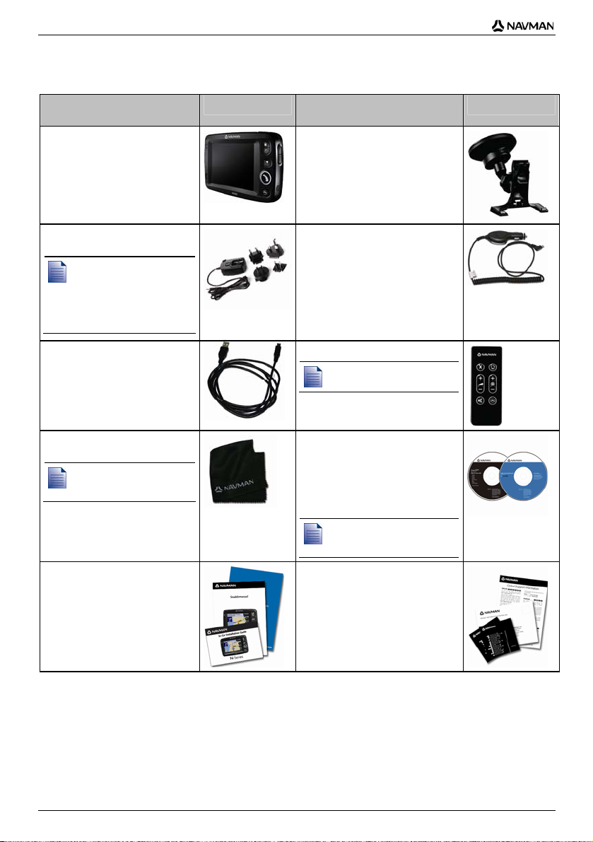
Box Contents
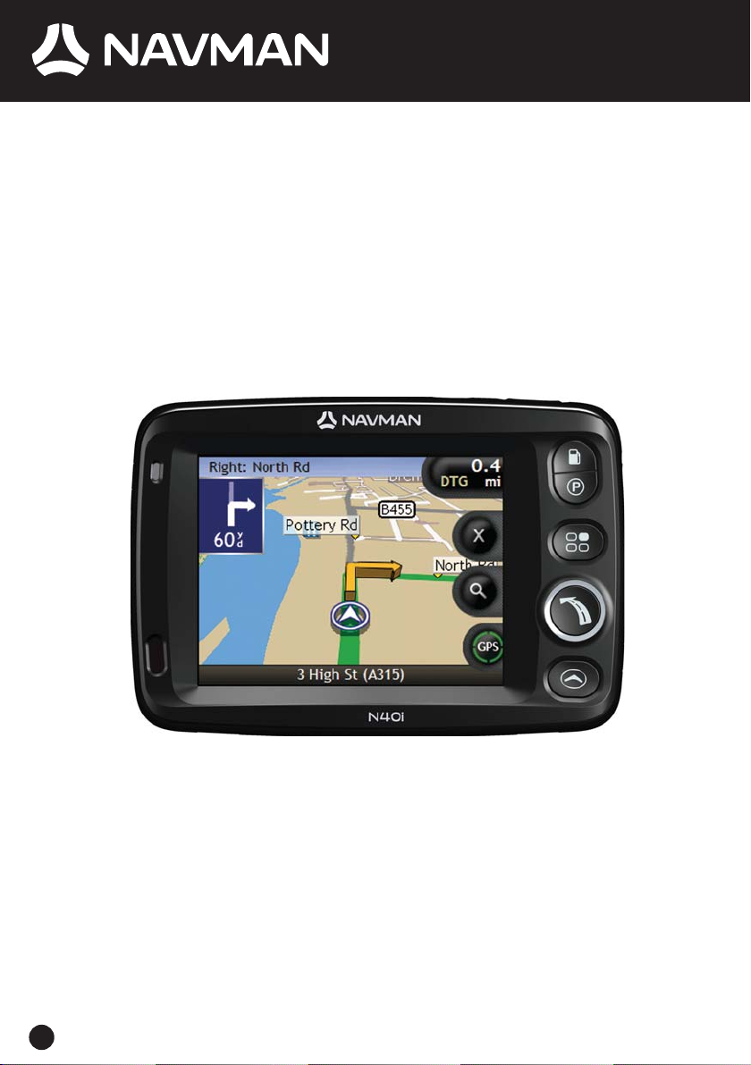
Item
Item
Navman with integrated GPS
receiver
100/240V AC Mains power-pack
for use in your home or office
The mains power-pack is
not supplied with all
models.
The number of plugs
included depends on the
country of purchase.
USB cable to connect your
Navman to your computer,
enabling software updates and
NavPix™ management
Protective carry-case and screencleaning cloth
The carry-case and screencleaning cloth are not
supplied with all models.
Documentation including:
Quick Reference Manual
In-Car Installation Guide
GPS Navigation - Frequently
Asked Questions guide
In-vehicle mounting bracket
12V DC In-vehicle power adaptor
with power cable
Remote Control
The remote control is not
supplied with all models.
CDs containing:
Smart 2006 SE software,
including Smart Desktop
and NavAlbum
Map data
Adobe
®
Reader®
The number of discs included
depends on the country of
purchase.
Documentation including:
Global Support Information
Software Product Licence
Limited Warranty Agreement
Registration card
8
Page 9
N-Series User Manual
Typographical conventions
It is important to understand the terms and typographical conventions used in this manual.
Formatting
The following kinds of formatting in the text identify special information:
Convention Type of Information
Bold Navman components or items displayed on screen, including buttons, headings, field
Italics
Icons
The following icons are used throughout this manual:
Icon Description
names and options.
Indicates the name of a screen.
Note
Important note
Tip
Case study
Warning
Terms
The following terms are used throughout this manual to describe user actions.
Term Description
Press Press and release a button quickly.
Select Tap an item in a list or tap a command from a menu.
Tap Press and release an item displayed on the touch screen.
Tap and hold Press and hold an item displayed on the touch scr een for 2-3 seconds.
9
Page 10
N-Series User Manual
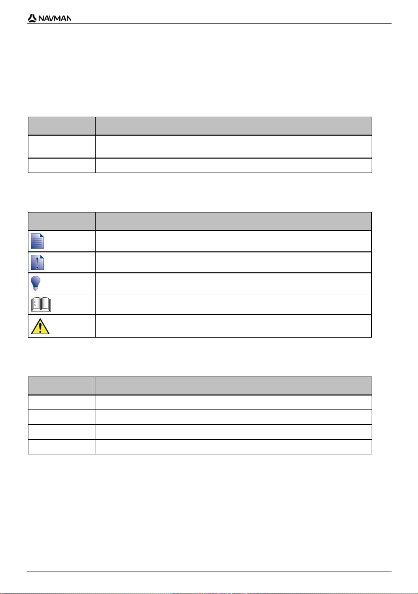
Getting to know your Navman
We recommend that you familiarize yourself with the Navman's basic operations.
Front components
Component Description
Battery indicator Indicates the level of internal battery charge:
Touch screen Displays maps and menu options.
Infrared receiver Receives signals from the remote control.
Green - battery full
Orange - battery charging.
Tap to select menu options or enter information.
The remote control is not supplied with all models.
Displays a list of the nearest petrol stations based upon your current
location.
Displays a list of the nearest parking areas based upon your current
location.
Displays the Preferences menu screen.
Displays the Go To Menu screen.
Cycles through the 3D Map, 2D Map, Next Turn and Turn-by-Turn™
screens.
10
Page 11
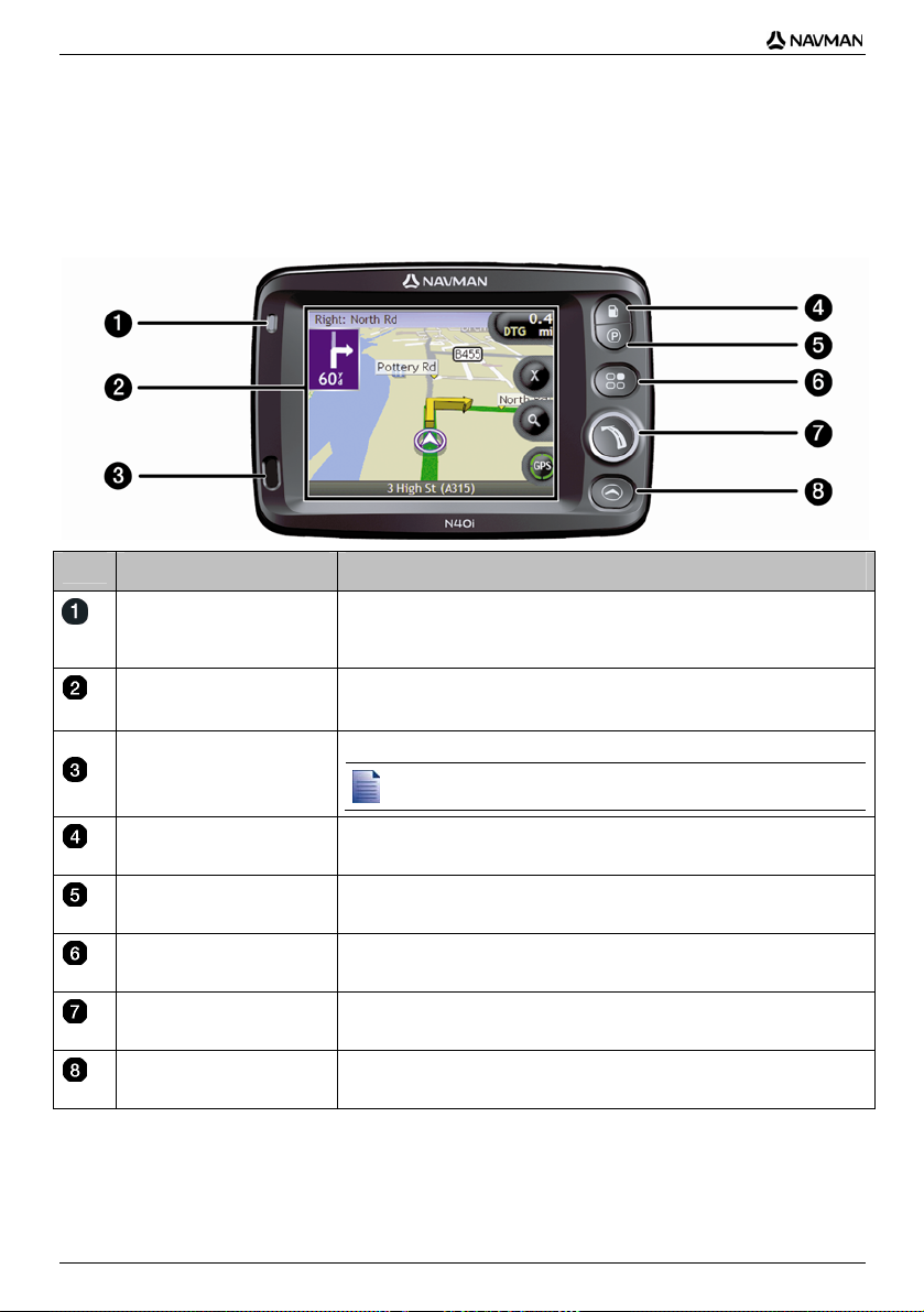
Side components
N-Series User Manual
Component Description
Volume control Press + to hear a sound test and adjust the volume up; press the - to hear a
Connection socket for GPS MMCX External Antenna (not included). To access
the socket, gently lift the rubber cover.
Slot for memory card. The memory card must be inserted with the label facing
the front of your Navman.
Connection socket for the following:
USB cable to your computer
AC power-pack to the mains power (not included with all models; may be
purchased separately)
In-vehicle power adaptor to the vehicle power socket.
sound test and adjust the volume down.
Connection socket for headphones or earphones (not included). To access the
socket, gently lift the rubber cover.
11
Page 12
N-Series User Manual
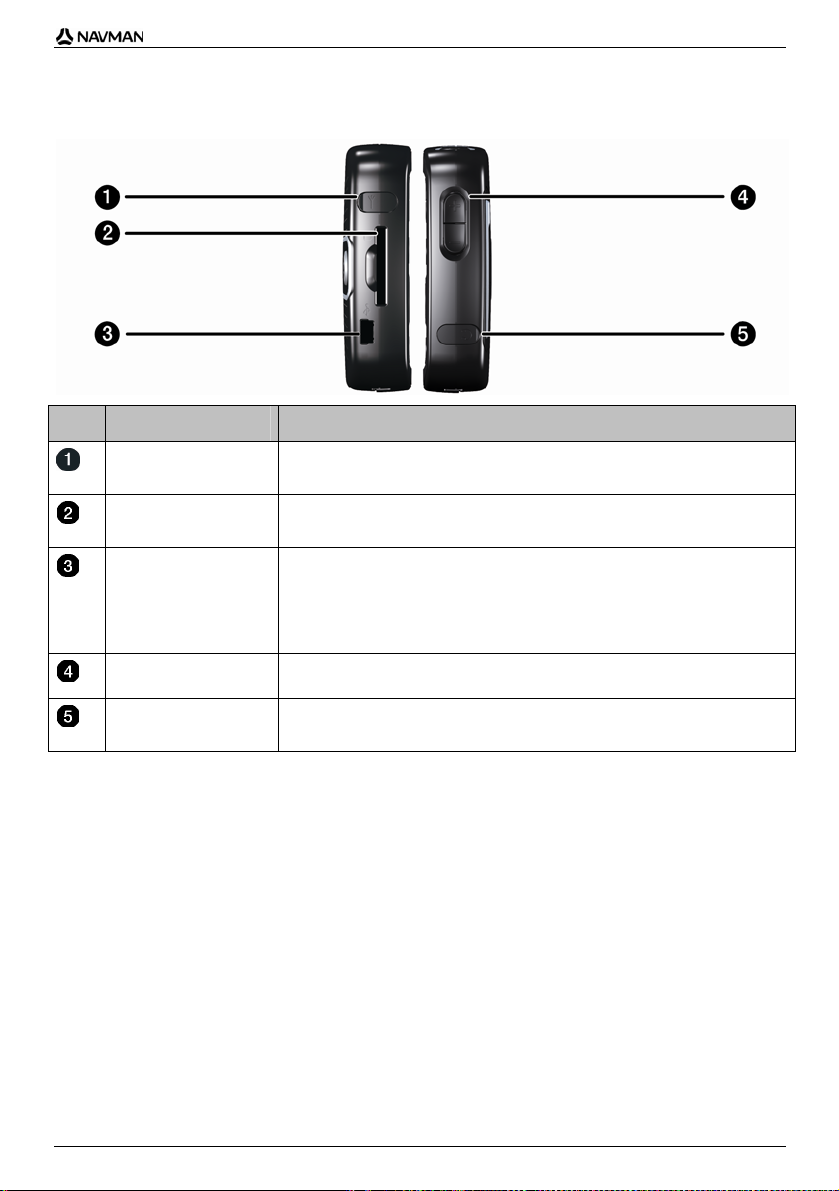
Back components
Component Description
Speaker Broadcasts voice commands and warnings. Use the Volume control to adjust
Mirror Enables you to see what the camera lens sees. You can then take a photo of
Camera The camera lens.
up or down.
yourself against the background of your choice.
The mirror is only available on models that include a camera.
The camera is not available on all models.
12
Page 13
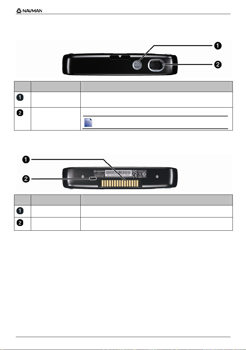
Top components
N-Series User Manual
Component Description
Turns the Navman on or off; when off, the Navman enters a suspended state.
Turns the camera on. Press to take a photo.
The camera is not available on all models.
Bottom components
Component Description
Hot shoe plate Connection plate for the P1 or T1 module (sold separately).
Battery Switch Must be set to | (on) for normal use. Switching to o (off) turns the battery off,
which saves battery power.
13
Page 14
N-Series User Manual
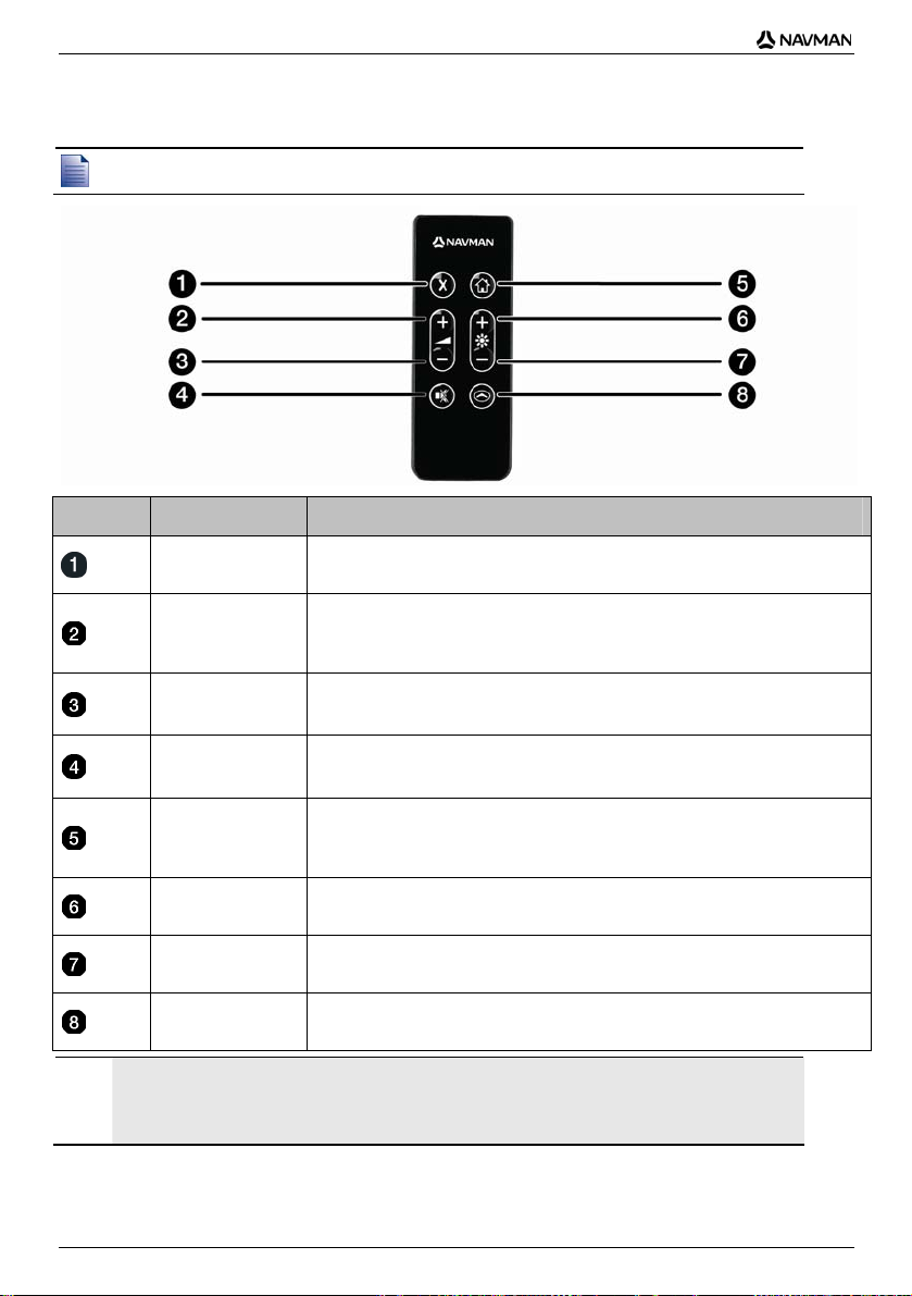
Remote Control
The remote control may be sold separately.
Component Description
CAUTION Do not expose the remote control to direct sunlight for prolonged periods. Overheating may damage the
remote control.
CAUTION If you are not going to use the remote control for three months or longer, remove the batteries from the
remote control.
Press twice to cancel the current route.
Increases the volume.
The on-screen volume bar displays as green and increases as the button is
pressed.
Decreases the volume.
The volume bar displays as green and decreases as the button is pressed.
Turns the sound off or on.
The volume bar displays as gray to indicate that the volume is muted.
Navigate to My Home.
Press once to display the My Home screen so that you can navigate home.
Press again to calculate the route to My Home and display the map screen.
Increases screen brightness.
Decreases screen brightness.
Cycles through the 3D Map, 2D Map, Next Turn and Turn-by-Turn™ screens.
14
Page 15

N-Series User Manual
Volume
The volume on your Navman can be adjusted either by the volume control on the Navman or by using
the volume control buttons on the remote control (may be sold separately).
Volume control
To hear a sound test and adjust the volume, press the Volume buttons located on the side of the
Navman up or down.
To mute the volume, press on the remote control (may be sold separately).
15
Page 16
N-Series User Manual
Internal battery
Your Navman has an internal battery that, when fully charged, should provide power for up to 4 hours.
The battery indicator light on the front of the Navman indicates the level of internal battery charge:
Green - battery full
Orange - battery charging
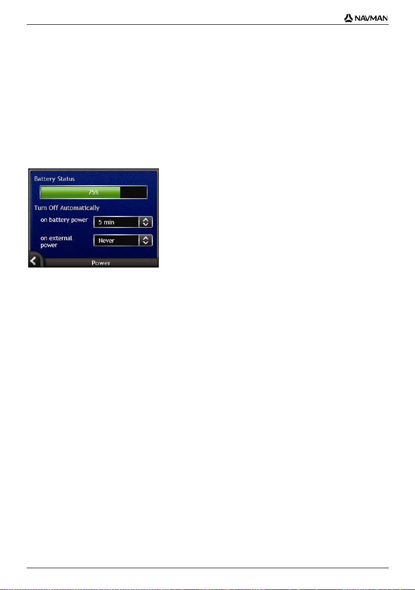
How do I monitor the battery status?
You can monitor battery power status on the Power screen (see "Power" on page 115).
How do I charge the internal battery?
The Battery Status bar displays External Power while the battery is under charge; when the battery
is fully charged, the Battery Status bar will display at 100%.
To charge the Navman in a vehicle, plug the vehicle power adaptor into
Navman and the other end into the vehicle power socket.
To charge the Navman using your computer, plug the large end of the USB cable directly into a
USB port on your computer (not a USB hub) and plug the small end into
Navman. To begin charging, ensure your Navman is turned off (press
To charge the Navman using an electrical wall outlet, plug the AC power cable into
of the Navman and the AC power pack into the wall outlet (not included with all models; may be
purchased separately).
on the side of the
on the side of the
).
on the side
16
Page 17
N-Series User Manual
How do I get started?
Before you begin, check if your vehicle is fitted with a heat-reflective or heated windscreen. If so, you
will need to purchase an external antenna for your Navman to receive GPS signals. For more
information, see the GPS Frequently Asked Questions guide.
To get started for the first time, complete the following steps:
Step Action
1 Turn your Navman on.
2 Select your preferred language.
3 Read and accept the warning message.
4 View the Tutorial.
1. Turn the Navman on
a) Position the Navman in your vehicle according to the instructions in the In-Car Installation Guide.
Please ensure that:
the Navman does not obstruct the driver's view, or interfere with the operation of the vehicle
airbags and safety devices.
the battery switch is on (|).
b) Press
to turn your Navman on.
The Navman will turn on and display the Language screen.
If your Navman was last turned off (o) via the battery switch, it will automatically turn on when the battery switch is
switched on (|).
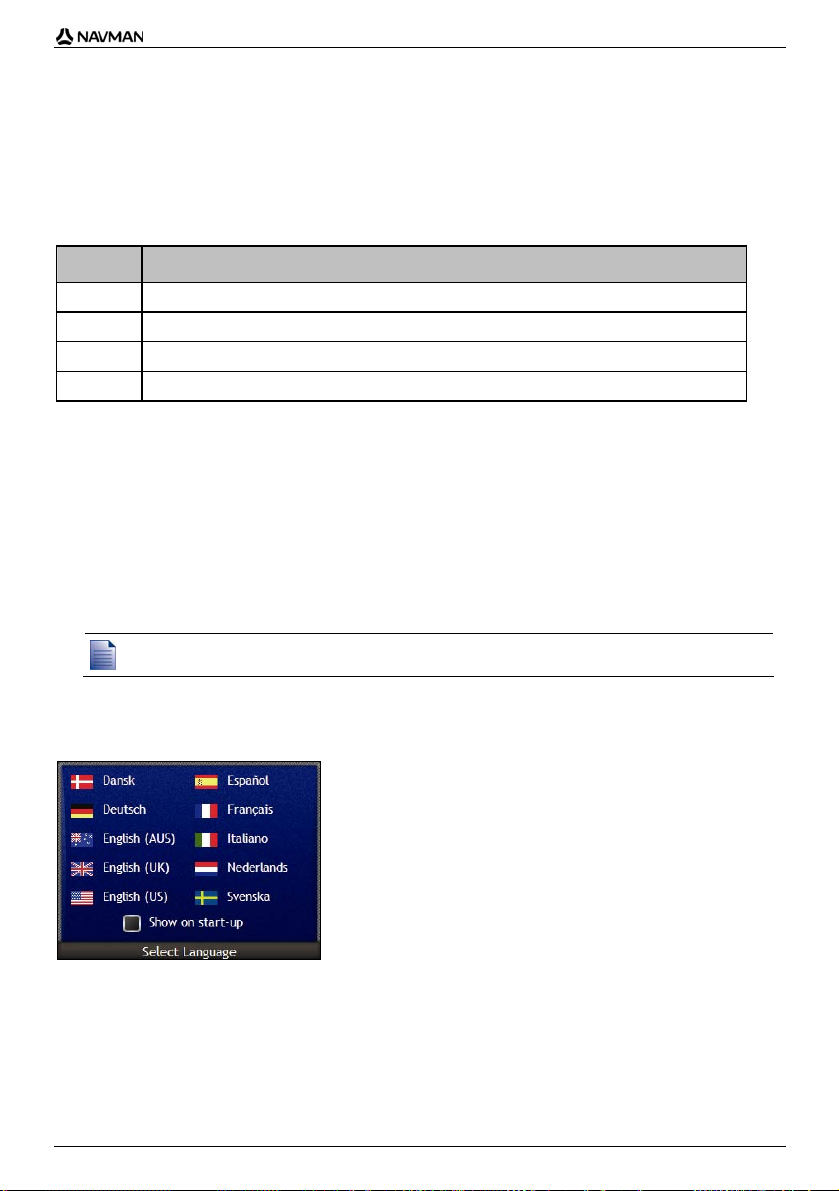
2. Select your preferred language
From the Select Language screen, tap your preferred language.
To prevent the Select Language screen from displaying on each startup, tap the Show on start-
up check box.
You can change your preferred language while using your Navman (see "Language" on
page 116).
17
Page 18

N-Series User Manual
3. Accept the warning message
a) The Warning screen will display when you have selected your preferred language.
Read the Warning message.
b) To confirm that you have read and understood the message, tap Accept.
The Tutorial will display.
If you have maps installed from multiple continents, you may be prompted to select the maps you would like to load
after you accept the warning message.
To use maps from a different continent at a later time, you can select a different continent via the Change Continent
screen in the Map Display preferences.
4. View the Tutorial
When you have accepted the Warning message, the Tutorial will display.
Read the Tutorial:
To prevent the Tutorial from displaying again on startup, tap the Show on start-up check box to
clear it.
To move forward through the Tutorial screens, tap
To revisit the previous screen, tap
You can view the Tutorial again while using your Navman (see "Tutorial" on page 111).
When you have finished the Tutorial, the 3D Map screen will display. If you have a GPS fix, your
current location will be displayed on the map.
.
.
18
Page 19
N-Series User Manual
How do I turn my Navman off?
To turn your Navman off, press .
Your Navman will enter a suspended state and the screen will turn off. When you turn your Navman
on again, it will return to the screen you were last viewing.
Power-saving suspended state
To save power, your Navman will automatically enter a suspended state after a pre-determined period
of time. You can change the default suspended state setting at the Power preference screen. For
more information, see "Power" on page 115.
If battery power is very low, your Navman will enter a suspended state whether you have set a predetermined period of time or not.
If you are not going to be using your Navman for an extended period of time, switch the battery switch to off (o) to
save battery power.
19
Page 20
N-Series User Manual
What are the main screens I
will use?
Map screens
There are four map screens used to view the route to your destination:
3D Map
2D Map
Next Turn
Turn-by-Turn™
To display the 3D Map screen, or the map screen that you were last viewing, press
cycle through the map screens.
; press again to
For more information on the map screens, see "How do I view my route?" on page 42.
For information on using the Map menu from the 3D Map and 2D Map screens, see "How do I
use the Map Menu?" on page 68.
Go To Menu screen
The Go To Menu screen is your starting point for specifying a destination. From the Go To Menu
screen you can navigate to My Home, a Favourite, a recent location, an address, a POI location or a
NavPix™ photo.
To access the Go To Menu at any time, press
icon.
For information on setting your destination, see "How do I go from A to B?" on page 22.
; to select a Go To Menu option, tap the required
20
Page 21
N-Series User Manual
How do I navigate with
GPS?
The Global Positioning System (GPS) is available at any time, free of charge, and is accurate to within
5m (15ft). GPS navigation is made possible by a network of satellites that orbit the Earth at around
20,200km (12,552mi). Each satellite transmits a range of signals which are utilized by GPS receivers,
such as your Navman, to determine an exact location. Although a GPS receiver can detect signals
from up to 12 satellites at any time, only four signals are required to provide a position or "GPS fix"
(latitude and longitude), for vehicle navigation systems.
Your Navman receives GPS signals via the internal GPS antenna. To guarantee the optimum GPS
signal strength, ensure your Navman is outdoors, or in a vehicle outdoors, and has an unobstructed
view of the sky. Your Navman can operate in all weather types except snowfall.
You can view your GPS status at any time from the map screens or the camera screens. The GPS
displays green when a GPS fix is established and red when a GPS fix is unavailable. To
icon
indicate the reception strength of a GPS fix,
displays between one and four green quadrants.
To see your GPS status in more detail, see "GPS Status" on page 114.
For more GPS information, see the GPS Navigation - Frequently Asked Questions guide.
21
Page 22
N-Series User Manual
How do I go from A to B?
Your Navman is equipped with maps that provide street-level detail for door-to-door navigation,
including Points of Interest such as accommodation, parking areas, petrol stations, railway stations
and airports.
When you ... Then ...
want to navigate to a NavPix™ photo
location
know the address of your destination use the address-entry wizard to enter the address (see "How
have multiple stops use the Multi-stop Trip Planner screen to enter multiple
need to find a named site, feature, landmark
or public venue
need to find a petrol station select from a list of the nearest petrol stations (see “How do I
use the NavPix Menu to navigate to a preinstalled NavPix
photo, or a NavPix photo that you have taken yourself (see
"How do I navigate to a NavPix photo?" on page 23).
do I search for an address?" on page 25).
waypoints (see "How do I create a trip with multiple stops?" on
page 30).
search for a Point of Interest (see "How do I search for a
landmark or venue?" on page 36).
find the nearest petrol station?” on page 36).
need to find a parking area select from a list of the nearest parking areas to your current
WARNING For your safety, enter destination information before you start a journey. Do not enter a destination while
driving.
location (see “How do I find the nearest parking area?” on
page 37).
What if I miss a turn?
Back-On-Track™ Automatic Rerouting
You will be redirected if you make a wrong turn. A message informing you that your route is being re-
calculated will display at the top of the screen. The Information button will display the percentage
complete status of the route re-calculation.
To cancel a route re-calculation tap
confirmed, both the re-calculation and your current route will be cancelled.
. A warning will display, asking you to confirm the cancellation. If
22
Page 23
N-Series User Manual
How do I navigate to a NavPix
photo?
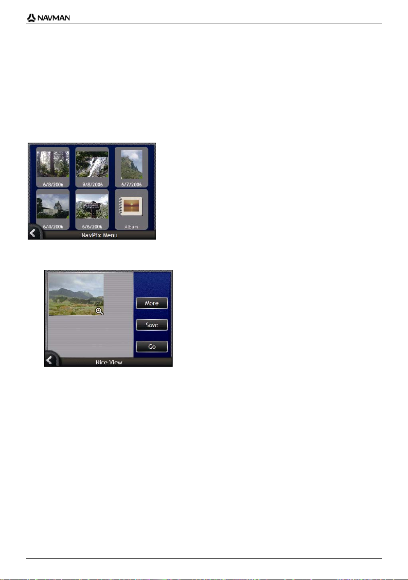
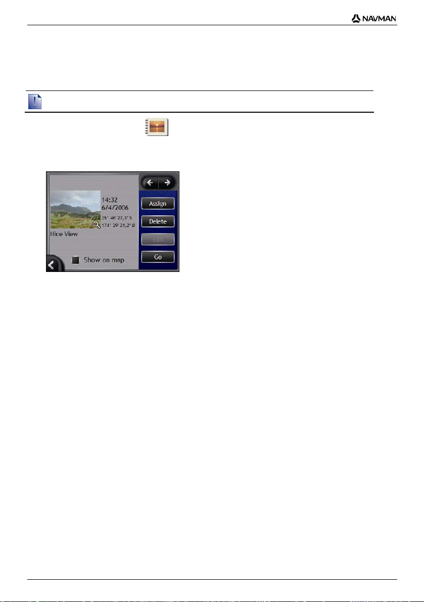
Your Navman contains preinstalled NavPix photos that you can navigate to. Your five most recently
used NavPix photos are displayed on the NavPix Menu. If you have not yet navigated to a NavPix
photo, five of the preinstalled NavPix photos will display.
1. Tap the photo you want to navigate to.
The NavPix Preview screen will display.
2. Tap Go.
Your route is calculated; the 3D Map screen will display.
23
Page 24
N-Series User Manual
How do I navigate to a NavPix photo I
have taken or downloaded?
To navigate to a photo location, a GPS fix must have been available when the photo was taken.
1. From the Album screen, select and tap a photo.
The Photo Details screen will display.
2. Tap Go.
Your route is calculated; the 3D Map screen will display.
24
Page 25
N-Series User Manual
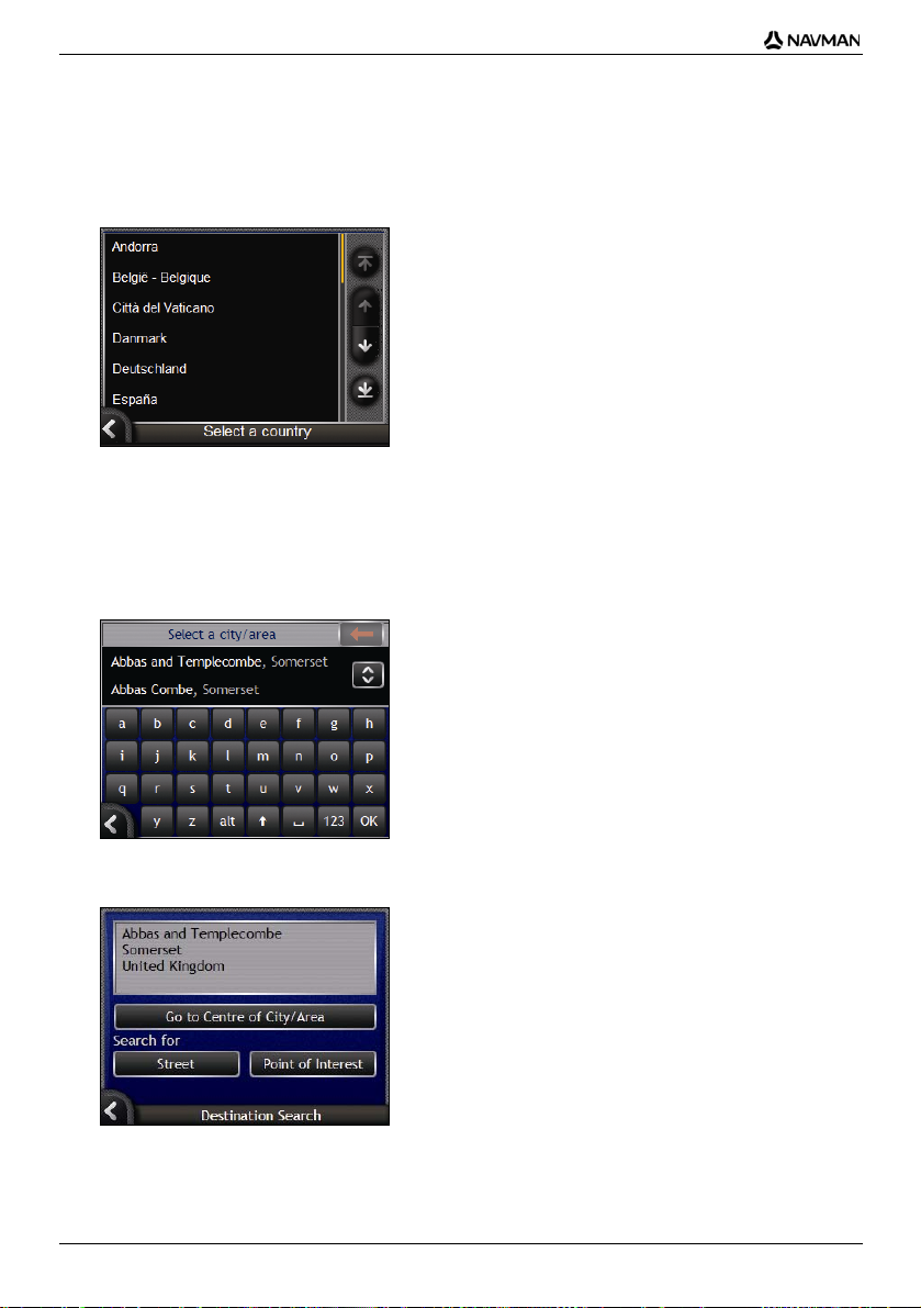
How do I search for an address?
Select a destination using the Destination Search, Keyboard and Destination Preview screens, which
used together form an address-entry wizard.
This section describes how to use each of these screens and provides a case study to help guide you
through setting your destination.
In some countries, you can search for your destination by postcode or zip code.
If you are in the United Kingdom, and you know the postcode of your destination, you can search for it from the
Destination Search screen by tapping Postcode, then entering a postcode of up to eight characters.
Quick Steps
1. Open the Destination Search screen
2. Select the country
3. Search for the city/area
4. Search for the street
5. Search for the house number
6. Tap Go.
Case Study:
How do I search for an address?
This case study will show you how to set your destination by selecting your country, then area, then
street, then house number.
1. Open the Destination Search screen
The Destination Search screen will display.
If this is the first time you are setting your destination and you have maps from more than one country installed, then
the Select Country screen will display instead of the Destination Search screen. Go directly to step 2b.
The next time you perform this procedure, the Destination Search screen will open as expected.
25
Page 26
N-Series User Manual
2. Select the country
If you only have the map of one country installed and selected, that country is selected for your
destination by default and cannot be changed. Go to step 3.
a) From the Destination Search screen, tap Change Country.
The Select a Country screen will display.
Select a country from the list.
The Destination Search screen will display.
3. Search for the City/Area
a) From the Destination Search screen, tap City/Area.
The Keyboard screen will display.
b) Use the Keyboard screen to search for the city or area of your destination.
The Destination Search screen will display.
26
Page 27
4. Search for the street
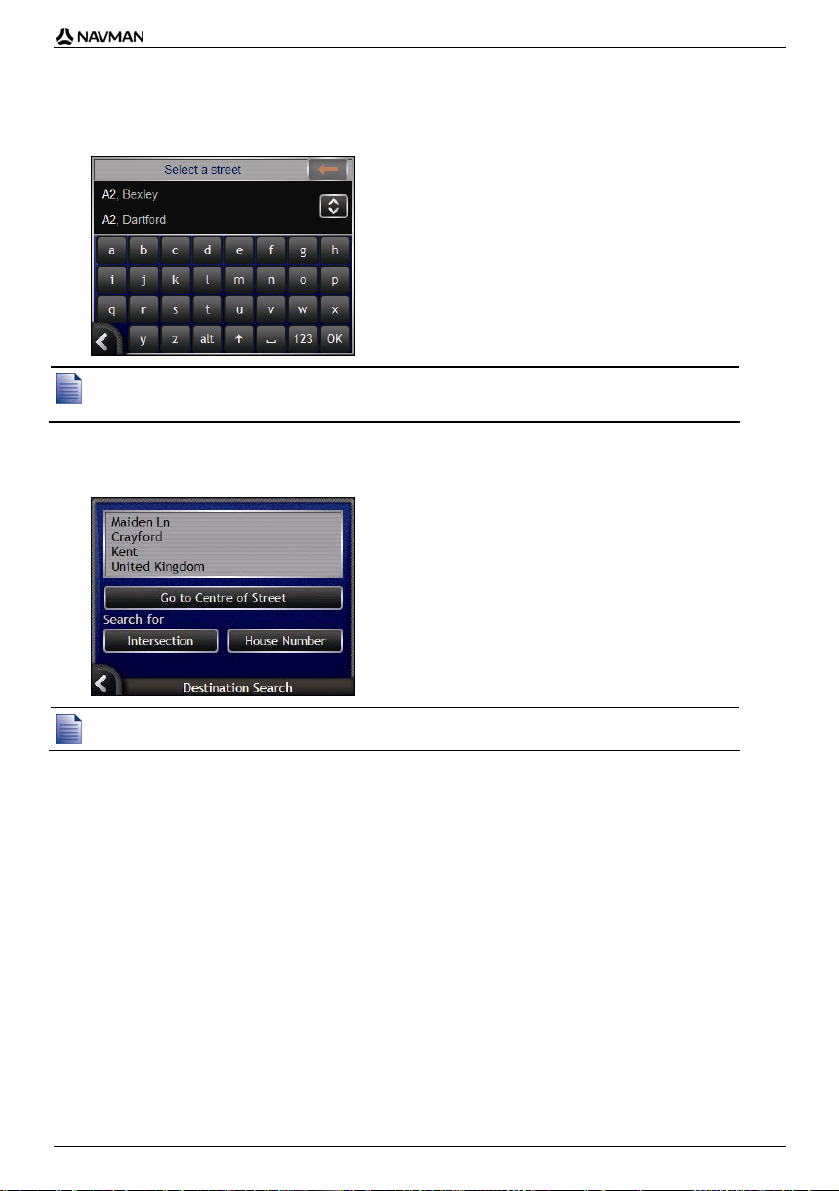
a) From the Destination Search screen, tap Street.
The Keyboard screen will display.
N-Series User Manual
There may be multiple matches for a particular street name. Long streets that run through several neighbouring
areas, and common street names; for example, Main Street, will produce matches that are distinguished by their
associated city or area name.
b) Use the Keyboard screen to search for the street of your destination. Where there are multiple
matches, select the city or area that best describes your destination.
The Destination Search screen will display.
If house numbers and intersection information are not available for your selected street, the Destination Preview
screen will display. Go to step 5c.
27
Page 28
N-Series User Manual
Using the Keyboard screen
The Keyboard screen will display when you are required to enter text, such as when searching
for a street name. As you tap each character, the first two matching results will display. Tap to
see more search results. Search results will be listed in matching order, with the closest matches
appearing at the top of the list. A maximum of 99 results will display.
The Keyboard screen can display in three modes: alphabet, alternate and number/symbol.
As you select each character, the first two results will display. Tap to see more search results.
To select a character or a search result, tap the character or search result.
To delete a character, tap .
To display the number/symbol Keyboard screen, tap 123.
To display the alternate Keyboard screen, tap alt.
To display the alphabet Keyboard screen, tap abc.
Using the Destination Search screen
The Destination Search screen is used to select your destination by area, street, postal or ZIP
code, Directory location, intersection, city, town, state or country.
As you specify each part of the address, it will display at the top of the screen.
The available options will change to reflect the parts of the address still to be completed.
28
Page 29
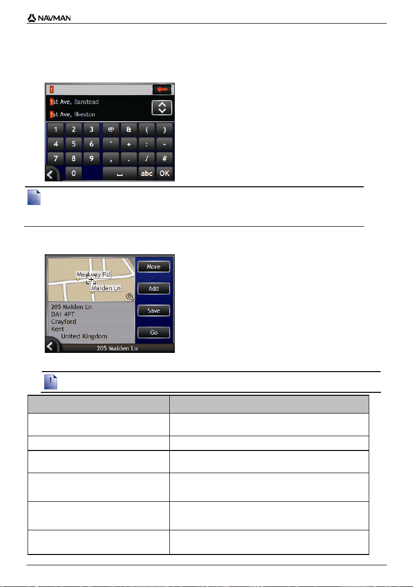
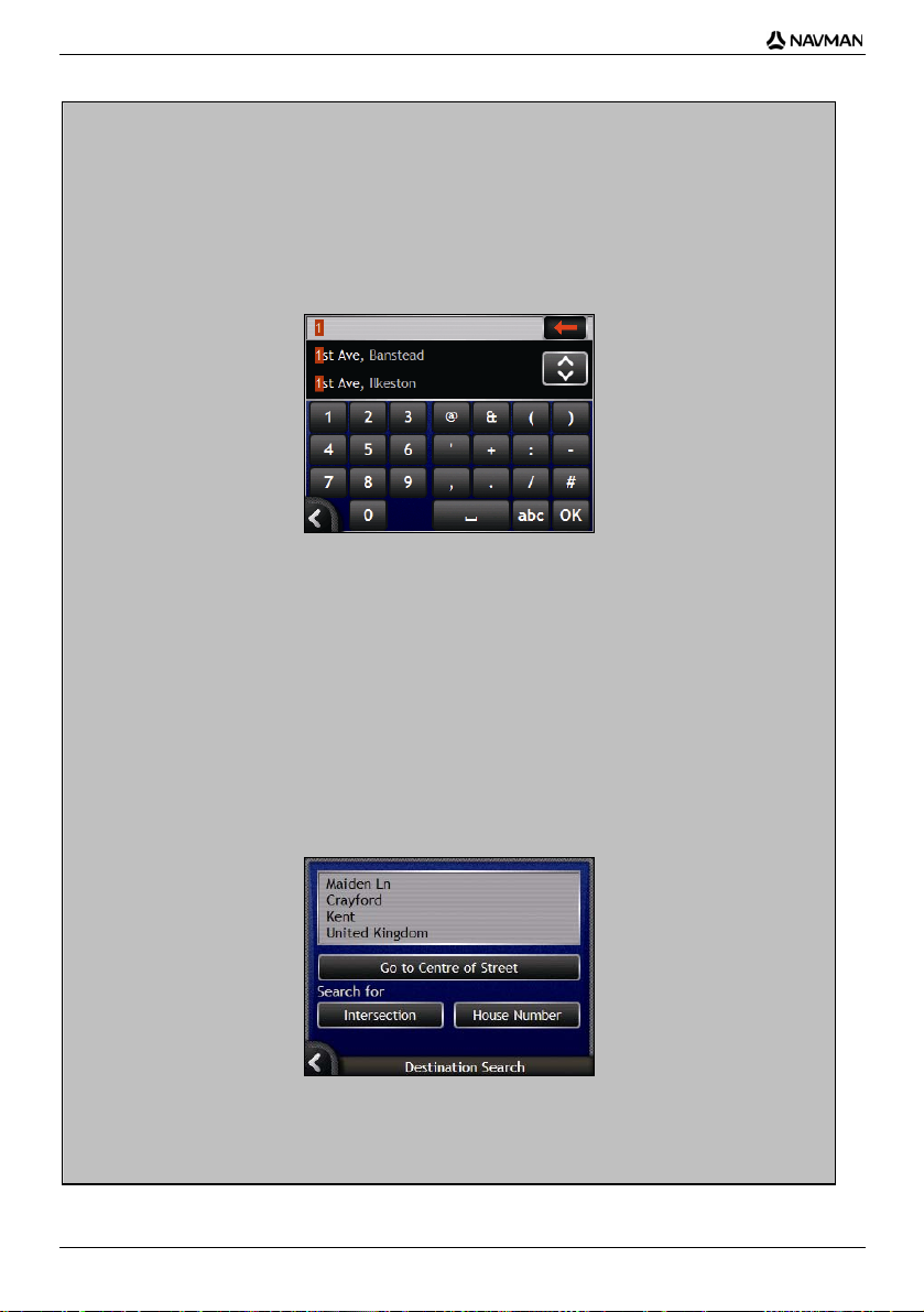
5. Search for the house number
a) From the Destination Search screen, tap House Number.
The Keyboard screen will display.
N-Series User Manual
If house numbers are available, but not the one that you require, you may have to choose the same street in a
neighbouring area. Go to step 4.
If the House Number option is not displayed at all, house numbers are not available for your selected section of the
street. Tap Go to Centre of Street to display the Destination Preview screen. Go to step c.
b) Use the Keyboard screen to search for the house number of your destination.
The Destination Preview screen will display.
c) Complete one of the following:
Ensure that the route preferences are applicable for the route that you have specified, before you tap Go.
If you want to ... Then ...
calculate the route and open the 3D Map
screen
view the position on the map screen tap the map to display the position on the 2D Map screen..
add the destination to a multi stop trip tap Add.
save the destination as My Home
save the destination as a Favourite
change your destination
tap Go.
Your route is calculated; the 3D Map screen will display.
The Multi-stop Trip Planner screen will display.
tap Save.
The New Favourite screen will display.
Tap Save as Home.
tap Save.
The New Favourite screen will display.
Tap Save as Favourite.
.
press
The Destination Search screen will display.
29
Page 30

N-Series User Manual
How do I create a trip with multiple
stops?
You can use the Multi-stop Trip Planner screen to set multiple waypoints for your trip. Your route will
be calculated to go via each of these points in the specified order.
Waypoints can be added via the Multi-stop Trip Planner screen or by selecting Location from the popup Map menu on the 2D Map or 3D Map screen, then Add to Trip. You can save up to 198 multi-stop
trips, each with up to 14 waypoints.
Waypoints added, updated or deleted after a multi-stop trip has commenced will not affect the current route.
Quick Steps
1. Start your Multi-stop Trip
2. Select the country
3. Search for the city/area
4. Search for the street
5. Search for the house number
6. Tap Go.
30
Page 31

N-Series User Manual
Case Study:
How do I navigate to multiple
addresses?
This case study will show you how to set a multi-stop trip by selecting your country, then area, then
street, then house number for each waypoint.
1. Start your multi-stop trip
Multi-stop Trip Planner
The Multi-stop Trip Planner screen will display.
a) Tap Add.
The Add to Trip Menu will display.
b) Tap Address.
The Destination Search screen will open.
You can also add waypoints using Favourites, recent destinations, POI locations and Navpix.
31
Page 32

N-Series User Manual
2. Select the country
If you only have the map of one country installed and selected, that country is selected for your
destination by default and cannot be changed. Go to step 3.
a) From the Destination Search screen, tap Change Country.
The Select a Country screen will display.
Select a country from the list.
The Destination Search screen will display.
3. Search for the city/area
a) From the Destination Search screen, tap City/Area.
The Keyboard screen will display.
b) Use the Keyboard screen to search for the city or area of your destination.
The Destination Search screen will display.
32
Page 33

4. Search for the street
a) From the Destination Search screen, tap Street.
The Keyboard screen will display.
b) Use the Keyboard screen to search for the street of your destination.
The Destination Search screen will display.
N-Series User Manual
If house numbers and intersection information are not available for your selected street, the Waypoint Preview screen
will display. Go to step 5b.
5. Search for the house number
a) From the Destination Search screen, tap House Number.
The Keyboard screen will display.
If the House Number option is not displayed, house numbers are not available for your selected street. To display
the Destination Preview screen, tap Go to centre of street. Go to step c.
33
Page 34

N-Series User Manual
b) Use the Keyboard screen to search for the house number of your destination.
The Waypoint Preview screen will display.
c) Tap Add.
The destination is automatically saved and the Multi-Stop-Trip Planner screen will display.
d) Complete one or more of the following:
If you want to ... Then ...
add another waypoint
Waypoints added after a multi-stop trip has
commenced will not be included in the
current route.
calculate the route
change the order of your waypoints
delete all waypoints tap Clear.
delete one waypoint
save the multi-stop trip as a Favourite
tap Add.
The Multi-stop Trip Planner screen will display.
Return to step 3.
tap Go.
The Multi-stop Trip Preview screen will display.
Tap Go.
The Map screen will display the calculated route.
tap a destination point to move.
The Waypoint Preview screen will display.
Tap Up or Down.
The Multi-stop Trip Planner screen will display.
tap a destination point to delete.
The Waypoint Preview screen will display.
Tap Delete.
The Multi-stop Trip Planner screen will display.
tap Save.
The New Favourite screen will display.
Tap Save as Favourite.
The Favourite will save.
34
Page 35

N-Series User Manual
How do I skip a waypoint during a multistop trip?
You can modify a multi-stop trip at any time from the Multi-stop Trip Planner screen, however if you
have already commenced a trip, changes will not affect the current route:
Multi-stop Trip Planner
To skip a waypoint during a multi-stop trip, complete the following:
1. Tap the map to display the cross-hairs.
The Map Menu will display.
2. Tap Route, then Skip Waypoint.
The next waypoint will be skipped and the route recalculated to the following waypoint.
35
Page 36

N-Series User Manual
How do I search for a landmark or
venue?
Setting a Point of Interest (POI) as your destination
A POI is a named site, feature, landmark or public venue which can be displayed as an icon on the
map. POIs are grouped by type, such as petrol stations, parks, beaches and museums.
How do I find the nearest petrol
station?
You can press to quickly find the nearest petrol station.
Your Navman will show you a list of the nearest petrol stations based upon your current location.
a) Press
b) Select a petrol station from the list.
c) Tap Go.
.
The Select a point of interest screen will display, showing a list of the nearest petrol stations
based upon your current location. The nearest appears at the top of the list.
The Destination Preview screen will display.
Your route is calculated; the 3D Map screen will display.
36
Page 37

N-Series User Manual
How do I find the nearest parking
area?
You can press to quickly find the nearest parking area.
This case study will show you how to set your destination by locating and selecting a parking area.
The Navman will show you a list of the nearest parking areas based upon your current location.
a) Press
b) Select a parking area from the list.
c) Tap Go.
.
The Select a point of interest screen will display, showing a list of the nearest parking areas
based upon your current location. The nearest appears at the top of the list.
The Destination Preview screen will display.
Your route is calculated; the 3D Map screen will display.
37
Page 38

N-Series User Manual
How do I search for other POIs?
Select a POI destination using the Destination Search, Keyboard and Destination Preview screens,
which used together form a POI-entry wizard.
This section describes how to use each of these screens and provides a case study to help guide you
through setting your POI.
In some countries, you can search for your destination by postcode or zip code.
If you are in the United Kingdom, and you know the postcode of your destination, you can search for it from the
Destination Search screen by tapping Postcode, then entering a postcode of up to eight characters.
Quick Steps
1. Open the Destination Search screen
2. Select the country
3. Select the type of POI
4. Tap Go.
38
Page 39

N-Series User Manual
Case Study:
How do I search for a Point of
Interest?
This case study will show you how to set your destination by selecting a Point of Interest (POI).
1. Open the Destination Search screen
The Destination Search screen will display.
If this is the first time you are setting your destination and you have maps from more than one country installed, then
the Select Country screen will display instead of the Destination Search screen. Go directly to step 2b.
The next time you perform this procedure, the Destination Search screen will open as expected.
2. Select the country
If you only have the map of one country installed and selected, that country is selected for your
destination by default and cannot be changed. Go to step 3.
a) From the Destination Search screen, tap Change Country.
The Select a Country screen will display.
Select a country from the list.
The Destination Search screen will display.
39
Page 40

N-Series User Manual
3. Select the type of POI
To narrow the search for a POI, you can first search by Area or Postcode/ZIP code.
a) From the Destination Search screen, tap Point of Interest.
The Select POI Category screen will display.
b) Select a POI type from the list.
The Keyboard screen will display.
c) Use the Keyboard screen to find the POI.
The Destination Preview screen will display.
40
Page 41

N-Series User Manual
d) Complete one of the following:
Ensure that the route preferences are applicable for the route that you have specified, before you tap Go.
If you want to ... Then ...
calculate the route and open the 3D Map
screen
view the position on the map screen tap the map to display the position on the 2D Map screen..
add the destination to a multi stop trip tap Add.
save the destination as My Home
save the destination as a Favourite
change your destination
tap Go.
Your route is calculated; the 3D Map screen will display.
The Multi-stop Trip Planner screen will display.
tap Save.
The New Favourite screen will display.
Tap Save as Home.
tap Save.
The New Favourite screen will display.
Tap Save as Favourite.
.
press
The Destination Search screen will display.
41
Page 42

N-Series User Manual
How do I view my route?
Once a route has been calculated, the 3D Map screen will display. You will be directed to your
destination by vocal and visual instructions.
You can view your route in several ways by pressing
3D Map screen
The 3D Map screen is oriented to your travelling direction.
To view the 3D Map screen when a route has been calculated, press
Tap and drag the screen, to move across the map.
Tap the map, to view the Map Menu (see "How do I use the Map Menu?" on page 68).
to cycle through the map screens.
to cycle through the screens.
Item Description
Next instruction The direction and name of the street to turn in to.
Direction of next turn The direction of your next turn.
Distance to next turn The distance to your next turn.
Next turn arrow Your next turn is highlighted in a different colour from future turns.
Current position Your current position is marked with .
Status bar Displays one of the following:
To repeat the voice prompt of your next turn, tap the turn arrow.
The default colour of your next turn is orange, but will depend on the
colour theme you are using.
The name of the street you are located on
Speed warnings
Active POIs.
42
Page 43

Item Description
Information Displays one of the following options:
Route Your current route is highlighted.
Cancel route Cancels your current route.
Zoom
Compass and GPS
information
Time
km/h or mph (Speed)
TTG (Time to Go)
DTG (Distance to Go)
ETA (Estimated Time of Arrival).
Tap to cycle through the options.
During a Multi-stop trip, Time to Go, Distance to Go and ETA will display
as: Time to Waypoint, Distance to Waypoint and ETA at Waypoint.
To view zoom options, tap
To display a smaller area in greater detail, tap
To display a larger area in less detail, tap
Tap to cycle through the options;
Blue compass heading.
Green Quadrants - Indicates a valid GPS signal is being used to
fix your position. Between one and four quadrants will display
indicating the signal strength. Tap and hold to display the GPS
Status screen.
Red Circle - Indicates no GPS signal. Tap and hold to display
the GPS Status screen.
N-Series User Manual
.
.
.
43
Page 44

N-Series User Manual
2D Map screen
The 2D Map screen shows your current position (if a GPS fix is active) and surrounding street names.
If a route has been calculated, the route and turns are highlighted. The 2D Map screen is displayed
Course Up, unless the Map Display preference is set to North.
To view the 2D Map screen, press
Tap and drag the screen, to move across the map.
Tap the map, to view the Map Menu (see "How do I use the Map Menu?" on page 68).
to cycle through the screens.
Item Description
Next instruction The direction and name of the street to turn in to.
Direction of next turn The direction of your next turn.
Distance to next turn The distance to your next turn.
Current position Your current position is marked with .
Route Your current route is highlighted.
Scale bar Displays map scale.
Information Displays one of the following options:
When you cycle through the Information options, a function description
will display briefly at the top of the screen.
To repeat the voice prompt of your next turn, tap the turn arrow.
Time
km/h or mph (Speed)
TTG (Time to Go)
DTG (Distance to Go)
ETA (Estimated Time of Arrival).
Tap to cycle through the options.
During a Multi-stop trip, Time to Go, Distance to Go and ETA will
appear as: Time to Waypoint, Distance to Waypoint and ETA at
Waypoint.
44
Page 45

Item Description
Next turn arrow Your next turn is highlighted in a different colour from future turns.
Cancel route Cancels your current route.
Zoom
Compass and GPS
Information
Status bar Displays one of the following:
The default colour of your next turn is orange, but will depend on the
colour theme you are using.
To view zoom options, tap
To display a smaller area in greater detail, tap
To display a larger area in less detail, tap
Tap to cycle through the options;
Blue compass heading - Tap and hold to alternate between
displaying North or your destination at the top of the screen.
Tap and hold to display the GPS Status screen.
Green quadrants - Indicates a valid GPS signal is being used
to fix your position. Between one and four quadrants will
display indicating the signal strength. Tap and hold to display
the GPS Status screen.
Red circle - Indicates no GPS signal. Tap and hold to display
the GPS Status screen.
The name of the street you are located on
Speed warnings
Active POIs.
.
.
N-Series User Manual
.
45
Page 46

N-Series User Manual
Next Turn screen
The Next Turn screen displays information that you need for the next turn, the direction of the turn and
the distance to the turn. A route must first have been calculated, for this screen to be available.
To view the Next Turn screen when a route has been calculated, press
screens.
to cycle through the
Item Description
Next instruction The direction and name of the street to turn in to.
Direction of next turn The direction of your next turn.
Scale bar Displays map scale.
Distance to next turn The distance to your next turn.
Status bar Displays one of the following:
Information Displays one of the following options:
Cancel route Cancels your current route.
Map of next turn A map of your next turn.
When you cycle through the Information options, a function description
will display briefly at the top of the screen.
The name of the street you are located on
Speed warnings
Active POIs.
Time
km/h or mph (Speed)
TTG (Time to Go)
DTG (Distance to Go)
ETA (Estimated Time of Arrival).
Tap to cycle through the options.
During a Multi-stop trip, Time to Go, Distance to Go and ETA will appear
as: Time to Waypoint, Distance to Waypoint and ETA at Waypoint.
46
Page 47

Item Description
Current position Your current position is marked with ; if visible.
Compass and GPS
Information
Tap to cycle through the options;
Blue compass heading.
Green Quadrants -Indicates a valid GPS signal is being used to
fix your position. Between one and four quadrants will display
indicating the signal strength. Tap and hold to display the GPS
Status screen.
Red Circle - Indicates no GPS signal. Tap and hold to display
the GPS Status screen.
N-Series User Manual
47
Page 48

N-Series User Manual
Turn-by-Turn™ screen
The Turn-by-Turn screen displays the next four turns of your route, the turn direction, the street name
and the distance to the turn. You can view all the turns in the list, using the up and down arrows. A
route must first have been calculated for this screen to be available.
To view the Turn-by-Turn screen when a route has been calculated, press
screens.
to cycle through the
Item Description
Direction of turn The direction of the turn. Your next turn is highlighted.
Distance to turn The distance to your next turn. Your next turn is highlighted.
Instruction The direction and name of the street to turn in to. Your next turn is
Next turn (highlighted) Your next turn is highlighted at the top of the list.
Upcoming turns The direction and distance of upcoming turns.
Status bar The name of the street you are located on.
Cancel route Cancels your current route.
Scroll buttons Allow you to view each turn by moving up and down through the list.
highlighted.
48
Page 49

N-Series User Manual
How do I save Favourites and
My Home?
You can save up to 200 destinations as Favourites, one of which can be saved as My Home. My
Home can be any designated Favourite, but we recommend that it is your home or other common
destination.
You can save a Favourite from the Destination Preview screen after searching for an address, or from
the Maps Menu on the 3D or 2D Map screens. For more information, see "How do I use the Map
Menu?" on page 68.
Can I assign a photo to a Favourite?
You can assign a photo to any of your existing Favourites. For more information, see "How do I assign
a photo to a Favourite?" on page 64.
How do I save a Favourite?
Search for an address until the Destination Preview screen is displayed.
1. Tap Save.
The New Favourite screen will display.
2. To change the name of the Favourite, tap
After you have entered a name for the Favourite, tap OK.
The New Favourite screen will display.
3. Complete one of the following:
. The Keyboard screen will display.
49
Page 50

N-Series User Manual
If you want to ... Then ...
save as a Favourite tap Save as Favourite.
save as My Home tap Save as My Home.
The Favourite is saved. The Favourite Preview screen will
display.
The Favourite is saved as My Home. The My Home Preview
screen will display.
How do I navigate to a Favourite?
1. Tap the Favourite destination you want to travel to.
The Favourite Preview screen will display.
2. Tap Go.
The route is calculated and displayed on the Map screen.
50
Page 51

N-Series User Manual
How do I navigate to My Home?
If you have not set an address as My Home, the first time you try to navigate to My Home you will be
prompted to search for an address using the address-entry wizard.
Option 1 - From the Go To Menu
The route is calculated and displayed on the Map screen.
Option 2 - From the Favourite Destinations screen
1. From the Favourite Destinations screen, select My Home.
The My Home screen will display.
2. To navigate to My Home, tap Go.
The route is calculated and displayed on the Map screen.
Option 3 - Using the remote control
You can navigate to My Home by pressing on the remote control (may be sold separately).
1. Press
2. Press
to display the My Home screen.
again, to calculate the route and display the 3D Map screen.
51
Page 52

N-Series User Manual
How do I edit the name of a
Favourite?
1. From the Favourite Destinations screen, select a Favourite to edit.
The Favourite Preview screen will display.
2. Tap Edit.
The Edit Name screen will display.
3. To edit the name of the Favourite, tap
After you have edited the Favourite name, tap OK.
The Edit Name screen will display.
4. Complete one of the following:
.
If you want to ... Then ...
rename the Favourite tap Save.
save as My Home tap Save as My Home.
The Favourite is saved. The Favourite Preview screen will
display.
The Favourite is saved as My Home. The My Home Preview
screen will display.
52
Page 53

N-Series User Manual
How do I delete a Favourite?
1. From the Favourite Destinations screen, select a Favourite to delete.
The Favourite Preview screen will display.
2. Tap Delete.
The Favourite is deleted. The Favourite Destinations screen will display.
53
Page 54

N-Series User Manual
How do I use the camera?
Your Navman has a built-in camera with NavPix™ technology, which allows you to take photos and
save them as geographical locations on the navigation maps. This enables you to navigate directly to
where the photo was taken. Photos can be stored in an Album on the Navman's hard drive or a
memory card and viewed in full screen mode. You can also share your photos with other NavPix
users by uploading them to www.navman.com/navpix
Download the User Manual for more information.
NavPix™ - Photos with GPS co-ordinates
The icon on the Viewfinder screen will display green if your Navman has a GPS fix. If a photo is
taken while a GPS fix is available, GPS co-ordinates are saved with the photo. A photo with GPS coordinates is called a NavPix photo and the co-ordinates can be navigated to.
When a NavPix photo is listed on the Album screen, a green triangle is displayed in the lower-right
corner of the photo. The GPS co-ordinates are displayed on the Photo Details screen (see "Photo
management" on page 60).
.
54
Page 55

N-Series User Manual
How do I take a photo?
Quick Steps
1. Press .
2. Point the camera at the required building, landscape, object or person.
3. Press
Detailed Steps
The Viewfinder screen must be displayed before you can take a photo.
1. To display the Viewfinder screen, press
2. When the Viewfinder screen is open, an image of whatever the camera is focused on will display.
3. When you are satisfied with the image displayed in the Viewfinder, press to take the photo.
4. The captured image will preview in the Viewfinder for two seconds before it is automatically
again to take a photo.
on top of your Navman.
Before you take a photo you can customize the lighting and brightness settings (see "How do I customize camera
preferences?" on page 57).
You can also tap to take the photo.
saved in your NavPix album on the Navman internal memory.
If the Viewfinder screen is inactive for more than two minutes it will revert to the map screen.
55
Page 56

N-Series User Manual
Viewfinder screen
The Viewfinder screen allows you to take photos and access the camera preferences.
To view the Viewfinder screen, press
Pressing will not take a photo unless the Viewfinder screen is displayed.
Element Description
Captures the photo.
Displays the Select an Album screen.
Returns you to the last screen viewed.
Displays the current lighting setting.
Tap to view lighting options.
Displays the brightness setting.
Tap to view brightness options.
on top of the Navman.
Viewfinder Allows you to frame the image within the Viewfinder.
Indicates if GPS information is available.
56
Page 57

N-Series User Manual
How do I customize camera preferences?
The camera has lighting and brightness settings which you can customize before taking a photo.
Lighting options
1. To view the Viewfinder screen, press .
2. From the Viewfinder screen, tap
The range of lighting options will display.
.
Setting Description
For outdoor use, in bright sunlight
For outdoor use, with cloud cover
For indoor use, under normal lighting
For indoor use, under fluorescent lighting
For night use; gives longer exposure time to enhance picture quality
Automatically selects the most suitable setting for the conditions
3. Tap your preferred lighting option.
Your selection will be saved.
Brightness options
The brightness control is adjustable to one of six levels.
1. To view the Viewfinder screen, press
2. From the Viewfinder screen, tap
The range of brightness options will display.
.
.
3. Select one of the six levels to set the brightness of a photo.
57
Page 58

N-Series User Manual
How do I manage my photos?
Album management
The photo albums store all your photos and display them as thumbnails. You can store your photos in
customizable albums on the Navman internal memory or store them on your memory card.
When you take a photo, it is always saved to the NavPix album on the Navman internal memory. You can then copy
it to another album or a memory card.
or
Element Description
Browse Displays the Select an Album screen. This displays a list of available albums.
Copy Copies selected photos from the displayed album to the memory card, or
Delete Deletes selected photos from the displayed album.
Album title The title of the album.
Photo thumbnail A photo thumbnail in the displayed photo album.
Scroll buttons Use the scroll buttons to scroll through the the photos.
from the memory card to the NavPix album.
Displays the previous screen.
To select a photo, tap the photo thumbnail.
The Photo Details screen will display.
To select multiple photos, tap and hold the first photo, then drag across
the other photos.
When a photo is selected it displays with a red border.
If the photo has been given a title it will display beneath the photo. If the photo
has not been given a title, the file name of the photo displays.
Displays if GPS co-ordinates are associated with the photo.
58
Page 59

N-Series User Manual
How do I copy photos to the album on my memory card?
Photos can be copied from the Albums on your Navman internal memory to your memory card and
vice versa.
The first time a photo is copied to your memory card, a folder will be created on the memory card called NavPix.
1. From the Album screen, tap Browse.
The Select an Album screen will display.
2. Select the Album you want to view.
3. Tap and hold, then drag across the screen to select the photo(s) you want to copy.
As a photo is selected, a red border will appear around it.
To cancel a selection, tap and drag over the photo(s) again.
4. When you have finished the selection, tap Copy.
5. A warning screen will display, asking you to confirm or cancel the procedure.
If confirmed, the photo(s) will be copied to the other Album.
You can also copy a single photo from the Photo Details screen. For more information, see "Photo management" on
page 60.
How do I delete photos from an Album?
Photos can be deleted from an Album on your Navman internal memory or your memory card.
When a photo has been saved as a Favou r ite destination, you will not delete the Favourite if you subseque ntly
remove the photo from your Album.
1. From the Album screen, tap Browse.
The Select an Album screen will display.
2. Select the Album you want to view.
3. Tap and hold, then drag across the screen to select the photos you want to delete.
As a photo is selected, a red border will appear around it.
To cancel a selection, tap and drag across the photo again.
4. When you have finished the selection, tap Delete.
5. A warning screen will display, asking you to confirm or cancel the procedure.
If confirmed, the photos will be deleted from the Album.
You can also delete a single photo from the Photo Details screen. For more information, see "Photo management" on
page 60.
59
Page 60

N-Series User Manual
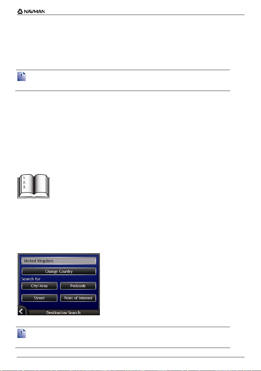
Photo management
The Photo Details screen displays information about your photo. Tap a photo to display the Photo
Details screen.
Element Description
Time / Date and
Location Co-ordinates
Photo A thumbnail of the photo.
Photo Title The title of the photo; tap Edit to add a title or edit the existing title.
Show on Map When selected, displays an icon on the map at the location the photo was
Scroll Bar Tap the Scroll buttons to scroll through your Album.
Assign Allows you to assign a photo to an existing Favourite, if GPS co-ordinates
Delete Deletes a photo from the album on your Navman or memory card.
Edit Allows you to create a title for a photo using the Keyboard screen.
Go Your route will be calculated and displayed on the 3D Map screen.
Displays the time and date the photo was taken. Displays the latitude and
longitude co-ordinates, if GPS co-ordinates are associated with the photo.
Tap to display the photo in full-screen.
taken.
Tap to return to your Album.
are associated with the photo.
The Go button is only available if GPS co-ordinates are associated with
the photo.
60
Page 61

How do I view a photo in full-screen?
1. From the Photo Details screen, tap the thumbnail of the photo.
The photo will appear in full-screen.
2. Complete the following:
If you want to ... Then ...
zoom into the photo
zoom out of the photo
rotate the photo
view parts of the photo not displayed onscreen
.
tap
.
tap
.
tap
The photo will rotate 90 degrees anticlockwise each time
tapped; the photo is saved at the new angle.
tap and hold the image, then drag across the screen.
N-Series User Manual
is
How do I add or edit a photo description?
A description can be added to your photo or an existing description can be edited. The description can
be a maximum of 34 characters.
1. From the Photo Details screen, tap Edit.
The Keyboard screen will display.
2. Tap each character as required.
The description will appear at the top of the screen.
3. When the description is complete, tap OK.
The Photo Details screen will display, with the new description under the photo.
61
Page 62

N-Series User Manual
How do I navigate to a NavPix
photo?
Your Navman contains preinstalled NavPix photos that you can navigate to. Your five most recently
used NavPix photos are displayed on the NavPix Menu. If you have not yet navigated to a NavPix
photo, five of the preinstalled NavPix photos will display.
1. Tap the photo you want to navigate to.
The NavPix Preview screen will display.
2. Tap Go.
Your route is calculated; the 3D Map screen will display.
62
Page 63

N-Series User Manual
How do I navigate to a NavPix photo I
have taken or downloaded?
To navigate to a photo location, a GPS fix must have been available when the photo was taken.
1. From the Album screen, select and tap a photo.
The Photo Details screen will display.
2. Tap Go.
Your route is calculated; the 3D Map screen will display.
63
Page 64

N-Series User Manual
How do I assign a photo to a
Favourite?
When a photo is assigned to an existing Favourite, only the image, and not the image co-ordinates, are associated
with the Favourite.
1. From the Album screen, select and tap a photo.
The Photo Details screen will display.
2. From the Photo Details screen, tap Assign.
The Assign Photo screen will display.
3. Complete the following:
If you want to ... Then ...
assign a photo to an existing Favourite
location
create a new Favourite (when GPS coordinates are associated with a photo)
tap
and select a Favourite destination from the list.
The Favourite title will display.
tap Save.
The photo is assigned to the Favourite and the Photo
Details screen will display.
tap
and select A new favourite from the list.
tap
.
The Keyboard screen will display. Enter a name for your
Favourite, then tap OK.
tap Save.
The photo is saved as a new Favourite and the Photo
Details screen will display.
64
Page 65

N-Series User Manual
How do I save, e-mail or print
photos?
To save, e-mail or print photos, you must first transfer the photos to your computer; there are two ways
to do this:
Copy the photos from a memory card to your computer via a memory card reader or memory
card drive, or
Copy the photos from your Navman to your computer via NavAlbum software on your computer.
Via Memory Card
Photos can be copied from the albums on your Navman internal memory to the My Pictures folder on
your memory card. The first time a photo is copied to the memory card, the following folders will be
created:
E:\My Documents\My Pictures, where “E” is the letter assigned to your memory card drive
or reader.
All photos in My Pictures are part of the same photo album and can be viewed on your Navman.
Once a photo has been copied to the photo album on your memory card, you can then use the card
with your computer to save, e-mail or print the photos, or take the memory card to a digital photo
retailer for printing.
Via NavAlbum
Photos can be copied from the Album on your Navman to your computer using NavAlbum software on
your computer (see "What is NavAlbum?" on page 98).
NavAlbum is installed on your computer at the same time that you install Smart Desktop (see "How
do I install Smart Desktop onto my computer?" on page 77).
65
Page 66

N-Series User Manual
What else can I do?
When you want to... Then ...
view your recent locations use the Recent Locations screen (see "How do I navigate to
access navigation features on the 3D Map
and 2D Map screens
a recent location?" on page 67).
use the Map Menu (see "How do I use the Map Menu?" on
page 68).
calculate a route that avoids a specified
area on the map
preview your route, or plan and view a route
without a GPS fix
view statistical information on both your
current trip and all trips to date
use an Avoid Area (see "How do I avoid an area?" on
page 70).
use the Route Demonstrator (see "How do I preview a
route?" on page 71).
use the Trip Meter screens (see "How do I view my route
statistics?" on page 73).
66
Page 67

N-Series User Manual
How do I navigate to a recent
location?
To make navigating to an address easier, your Navman will automatically save all your start locations
and destinations in a list of recent locations.
1. Tap a recent location.
The Recent Location Preview screen will display.
2. Complete one of the following:
If you want to ... Then ...
calculate the route and open the 3D Map
screen
view the full address details of the recent
location
save the recent location as My Home
save the recent location as a Favourite
change your destination
tap Go.
The 3D Map screen will display.
tap More.
The Recent Destination Details screen will display.
tap Save.
The New Favourite screen will display.
Tap Save as My Home.
tap Save.
The New Favourite screen will display.
Tap Save as Favourite.
.
press
The Recent Locations screen will display.
67
Page 68

N-Series User Manual
How do I use the Map Menu?
The Map Menu allows you to access navigational functions from the 3D Map and 2D Map screen.
Displaying the Map Menu
1. Tap to display the 3D Map or 2D Map screen.
2. Tap and drag to move around the map to your selected location.
3. Tap the map.
The Map Menu will display.
Map Menu options
The following options are available via the Map Menu:
Menu Option Description
Navigate To Calculates a route from your current location, once your current location
Show Details Displays the Location Details screen from which you can:
Location Displays the Location sub-menu from which you can:
is determined.
View details of the location
Add the location to your multi-stop trip
Save the location as a favourite
Navigate to the location.
Add To Favourites. Displays the New Favourite screen for you to
add the location as a favourite. For further information, see "How
do I save a Favourite?" on page 49.
Nearest POI. Displays the Select POI Category screen. Select the
directory, then the directory location to navigate to. For further
information, see "How do I search for a landmark or venue?" on
page 36.
Add To Trip. Adds the location to your multi-stop trip.
Set As Start Location. Sets the location as your departure point.
68
Page 69

Menu Option Description
Route Only available when navigating a route.
Displays the Route sub-menu from which you can:
Detour. Detours your route to avoid the next 1, 2, 5, 10 or 20
kilometres or the next 1, 2, 5, 10 or 20 miles.
Demonstrate. Starts the route demonstration, demonstrating
navigation from your current position or departure point.
Stop Demonstration. Stops the route demonstration.
Skip Waypoint. Skips the next stop on your multi-stop trip.
Show Entire Route. Displays your entire route on the 2D Map
screen.
Show Summary. Displays a summary of your route, including your
departure and destination addresses, total distance and total
estimated time to your destination.
Add Avoid Area Adds an Avoid Area for you to size.
Remove Avoid Area Deletes the selected Avoid Area.
N-Series User Manual
69
Page 70

N-Series User Manual
How do I avoid an area?
Your Navman can calculate a route that avoids a specified area on the map. Avoid Areas are
displayed as shaded areas.
CAUTION If no alternative route around an Avoid Area exists, the route calculation will fail.
CAUTION If your destination is in an Avoid Area, you will be routed into that Avoid Area.
How do I add an Avoid Area?
1. Tap the map to display the Map Menu.
2. Select Add Avoid Area.
3. Tap and drag to set the Avoid Area to the correct size and position.
The Avoid Area is added.
How do I delete an Avoid Area?
1. Locate the Avoid Area that you want to delete.
2. Tap the Avoid Area to display the Map Menu.
3. Select Remove Avoid Area.
The Avoid Area is deleted.
How do I delete all Avoid Areas?
The Saved Information screen will display.
1. Tap Delete Avoid Areas.
2. When the warning dialog-box opens, tap Yes to confirm.
All Avoid Areas are deleted.
70
Page 71

N-Series User Manual
How do I preview a route?
Route demonstration allows you to:
Preview a route.
Plan and view a route without a GPS fix, such as when you are inside a building.
The following steps will show you how to preview one route. To always preview your route, see
"Demonstration and Logging 4/4" on page 110.
1. Select a departure point
If you have a GPS fix, you do not need to select a departure point unless you want the demonstrated
route to start elsewhere.
a) Tap the map screen at your departure point.
The Map Menu will display.
b) Tap Location.
The Location submenu will display.
c) Tap Set As Start Location.
The Map Menu will close, and the selected point is set as your departure point.
2. Select a destination point
Set a destination either by using the address entry wizard or by using the Map Menu:
a) Locate your destination.
b) Tap your destination to display the Map Menu.
c) Tap Navigate To.
The Map Menu will close and the map screen will display the calculated route.
71
Page 72

N-Series User Manual
3. Demonstrate the route
Once the route has been determined, you can demonstrate the route by completing the following:
a) Tap the map screen to display the Map Menu.
b) Tap Route.
The Route submenu will display.
c) Tap Demonstrate.
The 3D Map screen will display the calculated route in Route Demonstration mode.
If you have selected the Loop demonstrations check box on the Demonstration and
Logging preferences screen, the Route Demonstration will continue to repeat the route.
72
Page 73

N-Series User Manual
How do I view my route statistics?
The Navman provides information on your:
distance travelled
average speed
maximum speed
time taken for trip
stationary time.
Trip information is presented in two different ways. These are:
information for the current trip
information for all trips to date, or since the tripmeter was last reset.
How do I view statistics on my current
route?
The Tripmeter - Current Route screen is used to view statistical information for your current trip.
a) Press and hold the Information button.
The Tripmeter - Current Route screen will display.
b) Complete one of the following:
If you want to ... Then ...
view statistics for your trips to date
reset the tripmeter
to display the Tripmeter - Global screen.
tap
tap Reset.
A Warning dialog box will display.
Tap Yes to reset.
The Tripmeter - Current Route screen will display.
73
Page 74

N-Series User Manual
How do I view statistics of my trips to
date?
The Tripmeter - Global screen is used to view statistical information for all of your trips to date, or
since the trip meter was last reset.
a) From the Tripmeter - Current Route screen, tap
The Tripmeter - Global screen will display.
b) Complete one of the following:
If you want to ... Then ...
view statistics for your current route
reset the tripmeter
.
to display the Tripmeter - Current Route screen.
tap
tap Reset.
A Warning dialog box will display.
Tap Yes to reset.
The Tripmeter - Global screen will display.
74
Page 75

N-Series User Manual
What is SmartST Desktop?
Smart Desktop is software for your computer and is used to install maps to your Navman.
You can also use it to:
remove maps from your Navman
obtain software updates
manage Custom Points of Interest
manage subscriptions to safety camera information.
Microsoft ActiveSync® and Microsoft .NET 2.0 will be installed on your computer as part of the installation of
In this section
How do I install Smart Desktop onto my computer?......................................................77
Smart Desktop features.................................................................................................79
How do I keep Smart up-to-date?..................................................................................82
How do I install maps onto my Navman?...........................................................................83
How do I install Custom Points of Interest?........................................................................92
How do I backup my Navman?...........................................................................................97
Smart Desktop.
75
Page 76

N-Series User Manual
Can I use Smart Desktop with m y
computer?
Ensure your computer has the following minimum system requirements before installing
Smart Desktop:
IBM compatible PC,
Microsoft® Windows® 2000 SP4 or XP SP2 (NT not supported),
Internet Explorer 6 or higher,
CD drive,
USB port,
Internet connection for registration.
You must install Smart Desktop from the Application Installer CD onto your computer hard drive; you cannot
run Smart Desktop from the CD.
What is Microsoft ActiveSync®?
Microsoft ActiveSync is used to establish a connection between your Navman and your
computer. ActiveSync 4.2 will be installed on your computer (if a later version of ActiveSync is
not already installed) as part of the installation of Smart Desktop.
After it is installed, ActiveSync will run in the Windows System Tray/Notification Area when you
start Windows. ActiveSync will activate when your Navman is connected to your computer.
For more information on ActiveSync, search for "ActiveSync" at www.microsoft.com.
How do I install a map for the first
time?
The most common task performed using Smart Desktop is the installation of a new map to
your Navman internal memory or memory card. Complete the following procedures:
Step Action
1 Install Smart Desktop on your computer (see "How do I install Smart Desktop onto my
2 Check for software updates for Smart on your Navman (see "How do I keep Smart up-
3 Install one or more maps on your Navman (see "How do I install maps onto my Navman?" on
computer?" on page 77).
to-date?" on page 82).
page 83).
76
Page 77

N-Series User Manual
How do I install Smart Desktop
onto my computer?
Before you begin:
Ensure that your computer meets the minimum system requirements for Smart Desktop, especially:
i. Ensure that Internet Explorer 6 or higher is installed on your computer before you install Smart Desktop, even if
it is not your default browser.
ii. Windows XP users, ensure that Windows XP Service Pack 2 or higher has been applied before you install
Smart Desktop.
1. Close all open programs on your computer.
2. Insert the Smart Application Installer CD into your computer CD drive.
The Smart Desktop installer will start.
If your computer does not automatically launch the CD, start the installation manually:
Start > Run.
Type D:\Install.exe where “D” is the letter assigned to your CD drive, then click OK.
3. Select your preferred language for Smart Desktop.
4. Click Install SmartST Desktop.
5. Follow the screen prompts to install Smart Desktop:
Review and accept the Licence Agreement for Smart Desktop and Microsoft ActiveSync
(if not already installed on your computer) when prompted.
Select a destination folder for Smart Desktop when prompted.
When the installation has finished, click Finish.
Smart Desktop will open.
6. If prompted to connect your Navman to your computer, complete the following:
Plug the large end of the USB cable directly into a USB port on your computer (not a USB
hub) and plug the small end into the USB Socket (
Where possible, plug the USB cable into a USB port at the back of your computer.
Press .
Your Navman will turn on.
77
) on the side of your Navman.
Page 78

N-Series User Manual
When the following screen displays on your Navman, click Next:
Microsoft ActiveSync will synchronize with your Navman.
You are now ready to use Smart Desktop to install maps to your Navman.
78
Page 79

Smart Desktop features
After Smart Desktop has been installed on your computer, you can access it from the Windows Start menu:
Start > All Programs > Navman > SmartST Desktop 2006 SE
N-Series User Manual
Element Description
Menu bar Menus that provide access to Smart Desktop functionality, including
Toolbars There are three toolbars:
Add Maps and
View/Remove Maps
tabs
Check for updates/
Update available
Globe A map of the world indicating the maps:
the ability to enter subscription information.
Status
Globe
Cursor
To display toolbars that are not on by default, select Toolbars on the
View menu.
For more information, see "Toolbars" on page 81.
Follow the steps on the Add Maps tab to install maps to your Navman,
memory card, or memory card via a memory card reader. For more
information, see "How do I install maps onto my Navman?" on page 83.
Follow the steps on the View/Remove Maps tab to remove installed
maps from your Navman, memory card, or memory card via a memory
card reader.
Click to check online for software updates or download software
updates.
on the current CD,
on a CD that came with the current CD,
installed on your Navman or memory card, or
available from Navman.
79
Page 80

N-Series User Manual
Element Description
Map Information The following information will display when you point to a map:
Map Colour Key A key for defining the different colours of the maps.
Map name
File size (if the map is on the inserted CD or a CD in the same
set)
Map status
Latitude Longitude co-ordinates in degrees, minutes and seconds
Local time offset UTC
To display the Latitude and Longitude co-ordinates and UTC offset,
click .
80
Page 81

Toolbars
The following toolbars are available in Smart Desktop:
Toolbar Button Description
Status
Indicates that your Navman is connected to your computer via
ActiveSync.
Indicates that your Navman is not connected to your computer .
N-Series User Manual
Globe
Cursor
Click to zoom in to the globe.
Click to zoom out of the globe.
Controls whether the globe automatically rotates to the correct maps
when a map CD is inserted in your CD drive.
Controls whether the globe is transparent.
Controls whether the day/night line is displayed on the globe.
Controls whether the maps are displayed on a globe or Mercator
Projection.
Controls whether the Latitude Longitude co-ordinates and UTC offset are
displayed in the pointer text.
Moving a toolbar
A toolbar is either docked in the grey area at the top of the screen, or floating on the screen.
To float a toolbar, click the portion of the toolbar to the left of the buttons and drag it to anywhere
on the screen.
To dock a toolbar, either double-click the top of a floating toolbar, or click and drag the toolbar
back to the grey area at the top of the screen.
To position a floating toolbar over a docked toolbar, press and hold CTRL while you drag the
toolbar to the required position.
Reshaping a toolbar
Click and drag the edge of a floating toolbar to reshape it. You cannot reshape a toolbar that is docked
at the top of the screen.
81
Page 82

N-Series User Manual
How do I keep Smart up-todate?
We recommend that you regularly use Smart Desktop to check the Navman server for Smart
software updates.
Updating vs. Upgrading
Updating software is different from upgrading software:
When you update Smart, the latest service packs and bug fixes are downloaded from Navman and applied to your
Navman.
To upgrade Smart, you must first purchase a new version of Smart from a retailer, then install it on your
Navman.
How do I update Smart?
1. If you connect to the Internet via a dial-up connection, connect to the Internet now.
2. Open Smart Desktop, follow the prompts, then click Check for updates.
Your computer will connect to the Navman server to check for software updates.
3. If a software update is available, complete the following:
a) Click Update available.
The Navman website will open.
b) Select the update for your region and download it to your computer.
c) On the Setup menu, select Update software, then Update software on Navman.
Follow the prompts to update your Navman software.
Can I automatically check for software updates?
To configure Smart Desktop to automatically check the Navman server for software updates, from
the Setup menu, select Update software, then Automatically check for software updates.
If a software update is available, complete step 3 above.
How do I upgrade from a previous version of Smart?
Follow the instructions in the Installation Guide or Upgrade Guide that came with your Smart
upgrade.
82
Page 83

N-Series User Manual
How do I install maps onto my
Navman?
Your Navman comes with one or more pre-activated maps.
You can install maps from the enclosed CDs to memory card or your Navman internal hard drive;
however you may need to purchase a Map Product Key to activate the maps.
Which map should I install?
If you are not sure which map contains the town or city that you want to install, you can use the Find
City window to identify the correct map. For more information, see "How do I know which map
contains a particular city or town?" on page 86.
How do I install maps from CD?
1. Open Smart Desktop, if it is not already open:
Start > All Programs > Navman > SmartST Desktop 2006 SE
2. Insert a Smart Map CD into your computer CD drive.
The preactivated maps that are ready to be installed to your Navman are light green.
The maps on the CD that require activation before being installed to your Navman are
light blue.
If your computer opens Windows Explorer when the CD is inserted, close the Windows Explorer window.
3. Complete the following:
If the map to be installed is ... Then ...
light green go to step 6.
light blue the map needs to be activated via the Internet before it
4. If you connect to the Internet via a dial-up connection, connect to the Internet now.
can be installed; continue to step 4.
83
Page 84

N-Series User Manual
5. Follow the prompts to activate your Map Product Key, including:
Enter the Map Product Key when prompted.
Your computer will connect to the Internet and activate your Map Product Key.
When activation has completed, the map will change colour to light green; continue to step 6.
6. Click the map you want to install to your Navman.
The map will change colour to dark green to indicate it has been selected. The map is now listed
in the Review Selected Maps section of the Add Maps tab.
To deselect a map, click the map again.
You may need to install multiple maps to cover the desired geographical area.
7. Complete the following:
If you want to ... Then ...
select a light green map go back to step 6.
select a light blue map the map needs to be activated via the Internet before it can be
select a Major Road Network (see "What is
a Major Road Network map?" on page 87).
install the selected maps to your Navman continue to step 8.
8. In the Step 3: Install Maps section, select the destination media for the selected maps, for
example, memory card or Navman internal memory.
installed; go back to step 4.
select the check box in the Step 1: Select Maps section.
84
Page 85

N-Series User Manual
9. Click Install Maps.
When they have been installed, the map or maps will change colour to yellow.
10. To use your Navman, disconnect the USB cable.
WARNING Do not disconnect the USB cable from the Navman USB Socket until the Globe has refreshed, and the
installed map or maps have changed colour to yellow.
How do I remove maps from my Navman?
1. Open Smart Desktop, if it is not already open:
Start > All Programs > Navman > SmartST Desktop 2006 SE
2. Click the View/Remove Maps tab.
The View/Remove tab will open, displaying a list of installed maps.
3. Select the name of the map you want to remove from the list, then click Remove.
4. Confirm that you want to remove the selected map when prompted.
The map is removed from your Navman.
85
Page 86

N-Series User Manual
How do I know which map contains a
particular city or town?
Use the Find City window to find the map that contains a particular city or town.
1. On the Map menu, select Find City.
The Find City window will open.
2. Type the name of the city or town in the City Name field.
The list of available cities will reduce to match your search.
3. Double-click the name of the city or town.
The Globe will rotate to centre on the selected city or town and
town location.
will mark the city or
86
Page 87

N-Series User Manual
What is a Major Road Network map?
Continuous continental navigation
Major Road Network maps allow you to seamlessly navigate between installed maps without installing
maps of all regions along your route. Each Major Road Network map covers a large area, such as
Western Europe, and contains main roads that connect cities and towns. You can select a road or
Point of Interest on the Major Road Network map as your departure point or destination.
All Major Road Network maps:
contain roads and ferry connections of high national and international importance.
use less memory than would be necessary to install all equivalent detailed maps.
exclude smaller roads and have a reduced level of geographical detail.
How do I install or reinstall a Major Road Network map?
Major Road Network maps can be installed to a new memory card or reinstalled to your Navman hard
drive using Smart Desktop. For more information, see "How do I install maps from CD?" on
page 83.
87
Page 88

N-Series User Manual
How do I subscribe to
Safety Camera
information?
Your Navman contains pre-loaded Safety Camera information.
Safety camera information is not available for all countries.
Special Offers
Special offers are automatically displayed the first time you connect to Smart Desktop.
There are two offers:
a free update (download) of the latest safety camera map data
on subscription you can get a total of 15 months of safety camera map information for the price of
12 months.
If you select the free update option then it is redeemed immediately. If you select the subscription
option, you will be directed to the Navman Store website.
You have a choice of selecting one OR the other special offer. If you select the subscription option, the free update is
no longer available.
Alerts
Safety Camera Directories can be set to enable a warning sound or visual warning when in close
proximity (see "Alerts" on page 127).
88
Page 89

N-Series User Manual
How do I check for special offers?
There are two types of special offers - an offer that requires you to purchase a subscription, and an
offer which is free.
The first time that you open Smart Desktop, the special offers will display automatically.
How do I view and select special offers?
1. Open Smart Desktop, if it is not already open:
Start > All Programs > Navman > SmartST Desktop 2006 SE
2. From the Subscriptions menu, select Check for Special Offers.
Your computer will connect to the Navman server to check for applicable special offers.
3. If special offers are available, complete the following:
a) Select a region to view the applicable special offers.
The available offers for that region will display.
b) Select a special offer and click Get Now.
If you select ... Then ...
a special offer that requires a paid
subscription
a free special offer Your software will update automatically.
The Navman Store website will open.
Follow the prompts to purchase a subscription.
A message will display, explaining that you will be sent a
product key.
Select Finish.
You will be emailed a product key.
Activate your subscription (see "Activate your
Subscription" on page 90).
select Finish.
89
Page 90

N-Series User Manual
How do I install Safety Camera
information?
If you do not accept the free download of the latest safety camera map information, you need to
complete the following steps to install safety camera information on your Navman.
1. Purchase a Subscription.
2. Activate your Subscription.
Purchase a Subscription
1. To purchase a subscription to safety camera information, on the Subscriptions menu, select
Purchase Subscription.
The Navman Store website will open.
2. Follow the prompts to purchase your subscription.
A product key will be sent to you via email when you have subscribed. You will need to use this
product key to activate your subscription.
Activate your Subscription
1. Open Smart Desktop, if it is not already open:
Start > All Programs > Navman > SmartST Desktop 2006 SE
2. To activate your subscription to safety camera information, from the Subscriptions menu, select
Activate Subscription Key.
The Activation window will display.
3. Complete one of the following:
If you ... Then ...
have been sent a product key for your
subscription via email
enter the product key in the Product Key field.
Click Next.
Follow the prompts to update your subscription.
Select Continue.
Your software will update automatically.
90
Page 91

N-Series User Manual
If you ... Then ...
require a product key
Click Buy.
The Navman Store website will open.
Follow the prompts to purchase a product key.
Go to step 2.
How do I check for subscription updates?
You can update a single safety camera subscription, or all of your current subscriptions.
How do I update subscriptions?
1. Open Smart Desktop, if it is not already open:
Start > All Programs > Navman > SmartST Desktop 2006 SE
2. From the Subscriptions menu, select Check for Subscription Updates, then select either a
single subscription or Update all Subscriptions.
Your computer will connect to the Navman server to check for applicable subscription updates.
3. If a subscription update is available, click Continue.
Your software will update automatically.
If ... Then ...
you have any expired subscriptions and
want to update them
you have any expired subscriptions and do
not want to update them at this time
you have expired subscriptions and never
want to update them
4. Select Finish.
Smart Desktop will display.
The Update subscriptions window will display, showing
expired subscriptions.
Select Update Now.
Select Continue.
The Navman Store website will open.
Update your subscription.
The Update subscriptions window will display, showing
expired subscriptions.
select Update Later.
The Update complete message will display.
Go to step 4.
The Update subscriptions window will display, showing
expired subscriptions.
select Never.
The Update complete message will display.
Go to step 4.
91
Page 92

N-Series User Manual
How do I install Custom Points of
Interest?
You can create custom Points of Interest by using the POI Editor in two ways:
by creating your own POI files, or
by using compatible POI files, such as safety camera locations, downloaded from the Internet.
Various POI files are available for download free or by subscription from third-party websites
that downloaded files are in .csv (Comma Separated Values) format.
A maximum of 25 custom POI files can be saved on your Navman. Each file corresponds to a POI
category; for example, Hotels.csv will be listed in your Navman as the Hotels category.
Alerts
Custom POI categories can be set to enable a warning sound or visual warning when in close
proximity (see "Alerts" on page 127).
1
. Ensure
1
Navman is not responsible for the content or accuracy of the information or the reliability or availab ility of these websites.The use of
information regarding safety camera locations may be subject to local laws in the country of use. You are responsible for checking that
you can use the information in your country or in the country where the information will be used.
92
Page 93

N-Series User Manual
How do I create a Custom Point of
Interest file?
Complete the following steps to create or edit a custom Point of Interest file containing the latitude and
longitude of individual Points of Interest. The file will be saved on your computer in .csv (Comma
Separated Values) format.
When you have finished creating or editing the file, you can copy it to your Navman. For more
information, see "How do I copy a Custom POI file to my Navman?" on page 94.
Map POI Editor
1. Complete one of the following:
If you want to ... Then ...
create a new Point of Interest file
open an existing Point of Interest file
Click
Type a name for the file in the File Name box, then
Click
Select the file from your local or network drive, then
2. Complete the following to add or edit a Point of Interest:
a) On the Edit menu, click New to create a new Point of Interest, or Modify to edit the selected
Point of Interest.
The Place Details window will open.
.
The Point of Interest File Name window will open.
click OK.
The file name will be used as both the name of the CSV file
and the Point of Interest name.
The file name cannot include spaces.
The category name will consist of the first 8 characters.
.
The Open dialogue box will open.
click Open.
The locations contained in the Point of Interest file
are listed.
b) Type a description for the Point of Interest in the Description box.
93
Page 94

N-Series User Manual
c) Complete one of the following:
If you know ... Then ...
the degrees, minutes and seconds of the
Point of Interest
the decimal degrees of the Point of Interest on the Decimal Degrees tab, type the latitude in the Latitude
d) Click OK to save the Point of Interest.
3. Repeat step 2 until all Points of Interest have been added to the Point of Interest file.
on the Degrees, Minutes, Seconds tab, type or select the
degree, minute and second of the latitude in the Latitude
boxes and the longitude in the Longitude boxes.
Select N, S, E or W to designate the hemisphere of the
co-ordinates.
box and the longitude in the Longitude box.
Select N, S, E or W to designate the hemisphere of the
co-ordinates.
4. Click
.
The Point of Interest file is saved.
You are now ready to copy your custom Point of Interest file to your Navman. For more information,
see "How do I copy a Custom POI file to my Navman?" on page 94.
How do I copy a Custom POI file to my
Navman?
Map Points of Interest
1. Open or create a POI file.
2. Click
The POI Options window will open.
.
You can open the POI Options window at any time by clicking .
94
Page 95

N-Series User Manual
3. Modify the POI settings as required:
If you want to ... Then ...
edit the POI category name type the name of the POI category in the POI Name field.
The file name cannot include spaces.
The category name will consist of the first 8 characters.
activate the POI to enable proximity
warnings
enable a visual warning when a POI of this
category is in close proximity
enable a warning sound when a POI of this
category is in close proximity
change the units used to measure distance
for this POI category
select the distance from a POI of this
category at which the visual warning should
display or the warning chime should sound
select an icon to display on the map
screens for POIs of this category
select a custom sound alert file to play
when a POI of this category is in close
proximity
4. Click OK to save the POI settings.
The Copy POIs window will open.
5. Select the destination media for the selected maps; for example, memory card or Navman
internal memory, then click Copy POI.
The POI file is saved to the Navman or memory card as a POI category.
select the Active check box.
If you do not activate the POI, you will not be able to
configure the Alert settings.
select the Visual Alert check box.
select the Audio Alert check box.
select either the Metric or Imperial option.
select the distance from the Distance box.
type the path to the icon file to be used to represent the POI
type, in the Icon File box, or click Browse to select the icon
file from your local or network drive. When you have located
the icon file, select it and click Open.
The icon file must be a bitmap (.bmp) graphic with a minimum
size of 6x6 pixels and a maximum size of 32x32 pixels.
If you do not select a custom icon, a default icon will
display.
select a sound file from the list.
The list of sounds is formed from default sound files and
sound files that you have added using My Sounds
Admin. For more information, see "How do I add sound
files to My Sounds Admin?" on page 95.
Click
to include a WAVE (.wav) sound file from your
computer or network.
Click to play the selected sound file.
If you do not select a custom sound file, a default sound
alert will play.
95
Page 96

N-Series User Manual
How do I add sound files to My Sounds Admin?
My Sounds Admin is used to compile a list of sound files for you to select an audible alert from when
editing the Point of Interest file options.
Map POI Editor
1. Click .
The My Sounds Admin window will open.
2. Add, delete or play sound files as required:
If you want to... Then...
add a sound file
delete a sound file
play a sound file
3. Click OK to save your list of sound files and close the My Sounds Admin window.
click
to select a WAVE (.wav) sound file from your local or
network drive. When you have located the sound file , select it
and click Open.
select the sound file from the list and click
select the sound file from the list and click
.
.
How do I delete a Custom POI File from my
Navman?
Map
1. Click .
2. Click the File Name or Size of the file to delete.
3. Click Delete.
4. To select another file to delete, go back to step 2; otherwise, continue to step 5.
5. Click OK and accept the changes.
Points of Interest
The Manage POI Files window will open, displaying a list of custom POI files installed on your
Navman.
The file is removed from the list, but is not yet deleted.
The selected file or files are deleted.
96
Page 97

N-Series User Manual
How do I backup my Navman?
You can save backups of the following information, and later restore them to your Navman:
Favourites and My Home
Preferences, including Point of Interest and photo preferences
Multi-stop trips
Recent locations.
How do I Backup my Navman?
1. On the File menu, select Backup.
The Backup/Restore window will open.
2. Click New Backup.
The New Backup window will display.
3. Click OK.
The New Backup window will close and your backup will be saved to your computer. The backup
will be listed on the Backup window.
4. Close the Backup/Restore window.
How do I Restore a Backup to my Navman?
1. On the File menu, select Restore.
The Backup/Restore window will open.
2. Select the backup from the list, then click Restore.
The backup will be restored to your Navman.
3. Close the Backup/Restore window.
How do I Delete a Backup?
1. On the File menu, select Backup.
The Backup/Restore window will open.
2. Select from the list the backup to delete.
3. Click Delete, then click OK.
The backup is deleted.
4. Close the Backup/Restore window.
97
Page 98

N-Series User Manual
What is NavAlbum?
NavAlbum is software for your computer which is used to transfer NavPix photos from your Navman
to your computer. You can then upload them to www.navman.com/navpix
NavPix users.
NavAlbum features
NavAlbum enables you to copy, delete or move photos or albums between the NavPix library on
your Navman and the NavPix library on your computer.
After NavAlbum has been installed on your computer, you can access it from the Windows Start
menu:
Start > Programs > Navman > NavAlbum
to share with other
Element Description
Menu bar Gives access to NavAlbum functionality.
Desktop albums Displays a list of all albums stored in the NavPix library on your
Navman albums Displays a list of albums stored on the Navman internal memory and
Album display area Displays thumbnails of photos in the selected album.
Selected photo When a thumbnail is selected it displays with a blue border.
Toolbar When a photo is selected, the icons which can be used will be active.
computer.
Click an album to display its contents in the Album display area.
Click the View all photos button to display all photos stored in the
NavPix library on your computer.
on the memory card if one is inserted.
Click an album to display its contents in the Album display area.
98
Page 99

Toolbar
The following options are available on the toolbar:
Button Description
Create new album Click to create a new album in the NavPix library you are viewing.
Rotate left Rotates the selected photo 90° to the left.
Rotate right Rotates the selected photo 90° to the right.
Transfer to your
Navman or
Transfer to your
computer
Import photos Imports photos from your computer to the NavPix library on your
View details Click to view the selected photo and edit photo details, including:
Export to disk Click to save photos to your computer or a network drive.
Delete Click to delete the selected photo(s).
If you are viewing photos in the NavPix library on your
computer, this will display as Transfer to your Navman.
Click to transfer the selected photo to your Navman.
If you are viewing photos in the Navman library this will display as
Transfer to your computer.
Click to transfer the selected photo(s) to the NavPix library on
your computer.
computer.
photo name
latitude
longitude
description.
N-Series User Manual
99
Page 100

N-Series User Manual
How do I use NavAlbum?
Before you begin:
Ensure your Navman is correctly plugged into your computer:
i. Plug the large end of the USB cable directly into a USB port on your computer (not a USB hub); plug the small end
into on the side of your Navman.
How do I copy photos or albums from my
Navman to my computer?
Photos taken with your Navman can be saved on your computer, printed, emailed to friends or shared
with other NavPix users around the world.
Quick steps
1. Copy photos or albums from your Navman.
2. View and edit photo details as required.
3. Transfer photos from your Navman to your computer.
4. Email or print photos or upload to the Internet.
Detailed steps
1. Copy photos or albums from your Navman
To copy one or more photos from your Navman to your computer, complete the following:
a) In the Navman albums section, select the album containing your required photos.
Thumbnails of the photos in the selected album will display in the Album display area.
b) Either click and drag the required photo or photos to an album in the Desktop albums section, or
click the Transfer to your computer icon on the toolbar.
If an album is not selected in the Desktop albums section, you will be prompted to either select one, or create a new
album.
c) Repeat steps a and b to copy photos from another album.
To copy one or more albums from your Navman to your computer, complete the following:
a) In the Navman albums section, select the album containing your required photos.
Thumbnails of the photos in the selected album will display in the Album display area.
b) Either drag the album to the Desktop albums section, or click the Transfer to your computer
icon on the toolbar.
100
 Loading...