


GPS NAVIGATION SYSTEM
KNA-G620T
GPS NAVIGATION
INSTRUCTION MANUAL
© B64-4718-08

Contents
Safety Precautions and Important
Information 4
Find It and Go! 9
Finding a Restaurant 9
Following Your Route 10
Adding a Via Point 10
Taking a Detour 10
Stopping the Route 10
Where To? 11
Searching Near Another Location 11
Go! Page Options 11
Finding an Address 11
Finding a Place by Spelling the Name 12
Using the On-Screen Keyboard 12
Finding Places in a Different Area 12
Narrowing Your Search 12
Getting Started 8
Manual Conventions 8
Tips and Shortcuts 8
Help When You Need It 8
The Main Pages 15
Viewing the Map Page 15
Trip Computer 15
Turn List Page 16
Next Turn Page 16
Lane Assist Page 16
GPS Info Page 16
Creating and Editing Routes 17
Creating a New Custom Route 17
Editing Custom Routes 17
Saving and Modifying the Active Route 17
Navigating a Saved Route 17
Deleting All Saved Routes 17
Stopping Your Route 17
Adding a Detour to a Route 17
Favorites 13
Saving Places You Find 13
Saving Your Current Location 13
Setting a Home Location 14
Finding Saved Places 14
Editing Saved Places 14
Deleting a Favorite 14
Using ecoRoute™ 18
Setting up ecoRoute 18
Viewing the Fuel Report 18
Calibrating the Fuel Economy 18
Adjusting the Fuel Price 18
Taking the ecoChallenge 19
Adjusting Your Vehicle Profile 19
Viewing the Mileage Report 19
Resetting ecoRoute Data 19
Calculating Routes that Use Less Fuel 19
2 GPS Navigation System Instruction Manual
Traffic Information 20
Understanding FM TMC Traffic 20
Traffic in Your Area 20
Traffic on Your Route 20
Viewing the Traffic Map 20
Viewing Traffic Delays 20
Customizing the Settings 21
Customizing the Navigation System 21
Changing the System Settings 21
Changing the Map Settings 21
Changing the Navigation Settings 21
Adjusting the Display Settings 21
Updating the Time Settings 21
Setting the Languages 21
Adding Security 21
Adjusting the Volume 21
Icons Used in This Manual
Appendix 22
Updating the Software 22
Updating the Map Data 22
Custom POIs (Points of Interest) 23
Important precautions are described to prevent injuries, etc.
Special instructions, supplementary explanations, limitations, and reference pages are described.
English 3

Safety Precautions and Important Information
Read this information carefully before starting to
operate the Kenwood Car Navigation System and
follow the instructions in this manual. Neither
Kenwood nor Garmin® shall be liable for problems
or accidents resulting from failure to observe the
instructions in this manual.
2WARNINGS
To prevent injury or fire, take the following
precautions:
• To prevent a short circuit, never put or leave any
metallic objects (such as coins or metal tools) inside
the unit.
• Do not watch or fix your eyes on the unit’s display
when you are driving for any extended period.
• Mounting and wiring this product requires skills and
experience. For safety’s sake, leave the mounting
and wiring work to professionals.
Failure to avoid the following potentially
hazardous situations could result in an
accident or collision resulting in death or
serious injury.
When navigating, carefully compare information
displayed on the navigation system to all available
navigation sources, including information from
street signs, visual sightings, and maps. For safety,
always resolve any discrepancies or questions
before continuing navigation.
Always operate the vehicle in a safe manner.
Do not become distracted by the navigation
system while driving, and always be fully aware
of all driving conditions. Minimize the amount of
time spent viewing the screen of the navigation
system while driving, and use voice prompts when
possible.
Do not enter destinations, change settings, or
access any functions requiring prolonged use of
the navigation system controls while driving. Stop
your vehicle in a safe and legal manner before
attempting such operations.
Keep the system volume at a low-enough level to
be able to hear outside noises while driving. If you
can no longer hear outside noises, you may be
unable to react adequately to the traffic situation.
This may cause accidents.
The navigation system will not display the correct
current position of the vehicle the first time it is
used after purchase, or if the vehicle battery is
disconnected. GPS satellite signals will soon be
received, however, and the correct position will be
displayed.
Be careful of the ambient temperature. Using the
navigation system at extreme temperatures can
lead to malfunction or damage. Also note that the
unit can be damaged by strong vibration, by metal
objects, or by water getting inside the unit.
2CAUTIONS
Failure to avoid the following potentially
hazardous situations may result in injury
or property damage.
The navigation system is designed to provide you
with route suggestions. It does not reflect road
closures or road conditions, weather conditions, or
other factors that may affect safety or timing while
driving.
Use the navigation system only as a navigational
aid. Do not attempt to use the navigation system
for any purpose requiring precise measurement of
direction, distance, location, or topography.
The Global Positioning System (GPS) is operated
by the United States government, which is solely
responsible for its accuracy and maintenance. The
government system is subject to changes that
could affect the accuracy and performance of all
GPS equipment, including the navigation system.
Although the navigation system is a precision
navigation device, any navigation device can be
misused or misinterpreted and, therefore, become
unsafe.
Information on disposal of old electrical
and electronic equipment (applicable for
EU countries that have adopted separate
waste collection systems)
Products with the symbol (crossed-out
wheeled bin) cannot be disposed as
household waste. Old electrical and
electronic equipment should be recycled
at a facility capable of handling these
items and their waste by products. Contact your
local authority for details in locating a recycle
facility nearest to you. Proper recycling and
waste disposal will help conserve resources while
preventing detrimental effects on our health and
the environment.
IMPORTANT INFORMATION
Vehicle Battery Preservation
This navigation system can be used when the
ignition key is turned to ON or ACC. To preserve the
battery, however, it should be used with the engine
running whenever possible. Using the navigation
system for a long time with the engine switched off
can cause the battery to run down.
4 GPS Navigation System Instruction Manual

Map Data Information
One of the goals of Garmin is to provide customers
with the most-complete and accurate cartography
that is available to us at a reasonable cost. We use
a combination of governmental and private data
sources, which we identify in product literature and
copyright messages displayed to the consumer.
Virtually all data sources contain some inaccurate
or incomplete data. In some countries, complete
and accurate map information is either not
available or is prohibitively expensive.
Software License Agreement
BY USING THE KNA-G620T, YOU AGREE TO BE
BOUND BY THE TERMS AND CONDITIONS OF THE
FOLLOWING SOFTWARE LICENSE AGREEMENT.
PLEASE READ THIS AGREEMENT CAREFULLY.
Garmin grants you a limited license to use the
software embedded in this device (the “Software”)
in binary executable form in the normal operation
of the product. Title, ownership rights, and
intellectual property rights in and to the Software
remain in Garmin.
You acknowledge that the Software is the property
of Garmin and is protected under the United
States of America copyright laws and international
copyright treaties. You further acknowledge
that the structure, organization, and code of the
Software are valuable trade secrets of Garmin and
that the Software in source code form remains a
valuable trade secret of Garmin. You agree not to
decompile, disassemble, modify, reverse assemble,
reverse engineer, or reduce to human readable
form the Software or any part thereof or create any
derivative works based on the Software. You agree
not to export or re-export the Software to any
country in violation of the export control laws of
the United States of America.
NAVTEQ® End-user License Agreement
The software embedded in your Garmin product
(the “Software”) is owned by Garmin Ltd. or its
subsidiaries (“Garmin”). The third-party map data
embedded in or accompanying your Garmin
product (the “Data”) is owned by NAVTEQ North
America LLC and is licensed to Garmin. Both the
Software and Data are protected under copyright
laws and international copyright treaties. The
Software and Data are licensed, not sold. The
Software and Data are provided under the
following license and are subject to the following
terms and conditions which are agreed to by End
User (“you” or “your”), on the one hand, and Garmin
and its licensors (including their licensors and
suppliers) and affiliated companies on the other
hand.
IMPORTANT: CAREFULLY READ THIS LICENSE
BEFORE USING
COPYING, OR OTHERWISE USING THIS PRODUCT
INDICATES YOUR ACKNOWLEDGMENT THAT
YOU HAVE READ THIS LICENSE AND AGREE TO
ITS TERMS. IF YOU DO NOT AGREE, RETURN THE
COMPLETE PRODUCT WITHIN 10 DAYS OF THE
DATE YOU ACQUIRED IT (IF PURCHASED NEW)
FOR A FULL REFUND TO ONE OF THE FOLLOWING:
(1) THE DEALER FROM WHICH YOU PURCHASED
THIS PRODUCT; (2) Garmin INTERNATIONAL, INC.
CUSTOMER SERVICE, 1200 EAST 151st STREET,
OLATHE, KS 66062, USA; (3) Garmin (EUROPE) LTD.,
LIBERTY HOUSE, HOUNSDOWN BUSINESS PARK,
SOUTHAMPTON, SO40 9LR, UNITED KINGDOM; OR
(4) Garmin CORPORATION CUSTOMER SERVICE, No.
68, JANGSHU 2nd ROAD, SIJHIH, TAIPEI COUNTY,
TAIWAN.
THIS PRODUCT. INSTALLING,
License Terms and Conditions
Garmin (“we” or “us”) provides you with storage
media containing the computer Software (the
“Software”) and the embedded or accompanying
digital map Data, including any “online” or
electronic documentation and printed materials
(together called the “Product” for purposes of this
License Agreement), and grants you a limited,
non-exclusive license to use the Product in
accordance with the terms of this Agreement. You
agree to use this Data together with the Garmin
product for solely personal, or if applicable, for
use in your business’ internal operations, and not
for service bureau, time-sharing, resale or other
similar purposes. Accordingly, but subject to the
restrictions set forth in the following paragraphs,
you may copy this Data only as necessary for your
use to (i) view it, and (ii) save it, provided that you
do not remove any copyright notices that appear
and do not modify the Software or Data in any
way. You agree not to otherwise reproduce, copy,
modify, decompile, disassemble, reverse engineer
or create derivative works of any portion of the
Product, and may not transfer or distribute it in
any form, for any purpose, except to the extent
permitted by mandatory laws.
Restrictions. Except where you have been
specifically licensed t
without limiting the preceding paragraph, you may
not use this Data with any products, systems, or
applications installed or otherwise connected to
or in communication with vehicles, and which are
capable of dispatch, fleet management or similar
applications where the Data is used by a central
control center in dispatching a fleet of vehicles. In
addition, you are prohibited from renting or leasing
o do so by Garmin, and
English 5

Safety Precautions and Important Information
the Data or the Garmin products containing the
Data to any other person or third party. Only those
rental car companies that are specifically authorized
by Garmin in writing to rent Garmin products
containing the Data to their rental customers are
permitted to rent out such products.
No Warranty. This Product (including the Data)
is pr
ovided to you “as is,” and you agree to use it
at your own risk. Garmin and its licensors (and
their licensors and suppliers) make no guarantees,
representations or warranties of any kind,
express or implied, arising by law or otherwise,
including but not limited to, content, quality,
accuracy, completeness, effectiveness, reliability,
merchantability, fitness for a particular purpose,
usefulness, use or results to be obtained from
the Product, or that the Data or server will be
uninterrupted or error-free.
Disclaimer of Warranty. Garmin AND ITS
LICENSORS (INCL
UDING THEIR LICENSORS AND
SUPPLIERS) DISCLAIM ANY WARRANTIES, EXPRESS
OR IMPLIED, OF QUALITY, PERFORMANCE,
MERCHANTABILITY, FITNESS FOR A PARTICULAR
PURPOSE OR NONINFRINGEMENT. NO ORAL OR
WRITTEN ADVICE OR INFORMATION PROVIDED BY
Garmin OR ITS SUPPLIERS AND LICENSORS SHALL
CREATE A WARRANTY, AND YOU ARE NOT ENTITLED
TO RELY ON ANY SUCH ADVICE OR INFORMATION.
THIS DISCLAIMER OF WARRANTIES IS AN ESSENTIAL
CONDITION OF THIS AGREEMENT. Some States,
Territories and Countries do not allow certain
warranty exclusions, so to that extent the above
exclusion may not apply to you.
Disclaimer of Liability. Garmin AND ITS
LICENSORS (INCL
UDING THEIR LICENSORS AND
SUPPLIERS) SHALL NOT BE LIABLE TO YOU: IN
RESPECT OF ANY CLAIM, DEMAND OR ACTION,
IRRESPECTIVE OF THE NATURE OF THE CAUSE
OF THE CLAIM, DEMAND OR ACTION ALLEGING
ANY LOSS, INJURY OR DAMAGES, DIRECT OR
INDIRECT, WHICH MAY RESULT FROM THE USE
OR POSSESSION OF THE INFORMATION; OR FOR
ANY LOSS OF PROFIT, REVENUE, CONTRACTS
OR SAVINGS, OR ANY OTHER DIRECT, INDIRECT,
INCIDENTAL, SPECIAL OR CONSEQUENTIAL
DAMAGES ARISING OUT OF YOUR USE OF OR
INABILITY TO USE THIS INFORMATION, ANY DEFECT
IN THE DATA OR INFORMATION, OR THE BREACH
OF THESE TERMS OR CONDITIONS, WHETHER IN
AN ACTION IN CONTRACT OR TORT OR BASED ON
A WARRANTY, EVEN IF Garmin OR ITS LICENSORS
HAVE BEEN ADVISED OF THE POSSIBILITY OF
SUCH DAMAGES. Garmin’S AND ITS LICENSORS’
TOTAL AGGREGATE LIABILITY WITH RESPECT
TO ITS OBLIGATIONS UNDER THIS AGREEMENT
OR OTHERWISE WITH RESPECT TO THE Garmin
PRODUCT OR THE DATA SHALL NOT EXCEED $1.00.
Some States, Territories and Countries do not allow
certain liability exclusions or damages limitations,
so to that extent the above may not apply to you.
Disclaimer of Endorsement. Reference to any
pr
oducts, services, processes, hypertext links
to third parties or other Data by trade name,
trademark, manufacturer, supplier or otherwise
does not necessarily constitute or imply its
endorsement, sponsorship or recommendation
by Garmin or its licensors. Product and service
information are the sole responsibility of each
individual vendor. The NAVTEQ name and logo,
the NAVTEQ and NAVTEQ ON BOARD trademarks
and logos, and other trademarks and trade names
owned by NAVTEQ North America LLC may not be
used in any commercial manner without the prior
written consent of NAVTEQ.
Export Control. You agree not to export from
an
ywhere any part of the Data provided to you or
any direct product thereof except in compliance
with, and with all licenses and approvals required
under, applicable export laws, rules and regulations.
Indemnity. You agree to indemnify, defend
and hold G
armin and its licensors (including
their respective licensors, suppliers, assignees,
subsidiaries, affiliated companies, and the
respective officers, directors, employees,
shareholders, agents and representatives of each
of them) free and harmless from and against any
liability, loss, injury (including injuries resulting in
death), demand, action, cost, expense, or claim of
any kind or character, including but not limited
to attorney’s fees, arising out of or in connection
with any use or possession by you of the Product
(including the Data).
Entire Agreement. These terms and conditions
constitut
e the entire agreement between Garmin
(and its licensors, including their licensors and
suppliers) and you pertaining to the subject matter
hereof, and supersedes in their entirety any and
all written or oral agreements previously existing
between us with respect to such subject matter.
Governing Law.
(a) F
or European Union NAVTEQ Data
The above terms and conditions shall be governed
by the laws of the Netherlands, without giving
effect to (i) its conflict of laws provisions, or (ii)
the United Nations Convention for Contracts for
the International Sale of Goods, which is explicitly
excluded. You agree to submit to the jurisdiction of
the Netherlands for any and all disputes, claims and
actions arising from or in connection with the Data
provided to you hereunder.
(b) For North American NAVTEQ Data and other
6 GPS Navigation System Instruction Manual

non-European Union NAVTEQ Data
The above terms and conditions shall be governed
by the laws of Illinois, without giving effect to (i) its
conflict of laws provisions, or (ii) the United Nations
Convention for Contracts for the International Sale
of Goods, which is explicitly excluded. You agree
to submit to the jurisdiction of Illinois for any
and all disputes, claims and actions arising from
or in connection with the Data provided to you
hereunder.
Government End Users. If End User is an agency,
department, or other entity of the United States
Government, or funded in whole or in part by
the U.S. Government, then use, duplication,
reproduction, release, modification, disclosure
or transfer of the Product and accompanying
documentation is subject to restrictions as set
forth in DFARS 252.227-7014(a)(1) (JUN 1995) (DOD
commercial computer software definition), DFARS
27.7202-1 (DOD policy on commercial computer
software), FAR 52.227-19 (JUN 1987) (commercial
computer software clause for civilian agencies),
DFARS 252.227-7015 (NOV 1995) (DOD technical
data – commercial items clause); FAR 52.227-14
Alternates I, II, and III (JUN 1987) (civilian agency
technical data and noncommercial computer
software clause); and/or FAR 12.211 and FAR 12.212
(commercial item acquisitions), as applicable.
In case of conflict between any of the FAR and
DFARS provisions listed herein and this License,
the construction that provides greater limitations
on the Government’s rights shall control. The
contractor/manufacturer is Garmin International,
Inc., 1200 East 151st Street, Olathe, KS 66062, USA
and NAVTEQ North America LLC, 222 Merchandise
Mart Plaza, Suite 900, Chicago, Illinois 60654.
Traffic Service End-user Subscriber
Agreement
The Traffic Service Provider holds the rights to
the traffic incident data and RDS/TMC network
through which it is delivered. You may not modify,
copy, scan, or use any other method to reproduce,
duplicate, republish, transmit, or distribute in any
way any portion of traffic incident data. You agree
to indemnify, defend, and hold harmless the Traffic
Service Provider (and its affiliates) and Garmin Ltd.
(and its subsidiaries) against any and all claims,
damages, costs, or other expenses that arise
directly or indirectly out of (a) your unauthorized
use of the traffic incident data or the RDS/TMC
network, (b) your violation of this End User
Subscriber Agreement and/or (c) any unauthorized
or unlawful activities by you in connection
herewith.
The Traffic Service Data is informational only. You
assume all risk of use. The Traffic Service Provider,
Garmin Ltd. (and its subsidiaries), and their
suppliers make no representations about content,
traffic and road conditions, route usability, or speed.
Garmin and its Traffic Service Provider(s) make no
warranty of fitness or compatibility of the traffic
data with the Garmin product and no warranty that
the traffic data will operate properly as integrated
and interfaced with the Garmin product. In
addition, Garmin and its Traffic Service Provider(s)
make no warranty with regard to the reliability,
accuracy, exhaustiveness and completeness of
the traffic data, which may contain inaccuracies
and/or errors from time to time. To the maximum
extent permitted by applicable law, any and all
warranties of any kind whatsoever with regard to
the traffic data are hereby expressly waived and
excluded, including, but not limited to, those of
merchantability, fitness for a particular purpose,
accuracy or completeness of the traffic data, and/or
a lack of viruses.
Garmin and its Traffic Service Provider(s) disclaim
all liability for any loss, injury, or damage resulting
from use of or inability to use the Garmin product
and traffic data as a result of weather difficulties,
the destruction of transmitters and/or other
broadcasting infrastructures, a natural disaster, and/
or a lack of reliability, completeness or accuracy
of the traffic data. In no event shall Garmin or
its Traffic Service Provider(s) be liable to you or
any other party for any compensatory, indirect,
incidental, special, or consequential damages
(including, without limitation, indirect, direct,
special, punitive, or exemplary damages for loss
of business, loss of profits, business interruption,
or loss of business information) arising out of the
use of or inability to use the Garmin product or the
traffic data, even if Garmin has been advised of the
possibility of such damages.
If you purchase or your Garmin product is preloaded with “lifetime” or “one-time” traffic, you will
receive traffic data for one (1) compatible Garmin
product until your product’s useful life expires
or Garmin no longer receives traffic data from its
Traffic Service Provider. Your traffic subscription
may not be transferred to another person or
another Garmin product. Garmin may terminate
this Agreement for any reason, including, but not
limited to, if Garmin finds that you have violated
any of the terms of this Agreement or the contract
between Garmin and its Traffic Service Provider
terminates.
English 7
Getting Started
The first time you use your Kenwood Navigation System, you need to set up your system. For complete
audio system information, see the other Kenwood manuals. The Help menu provides additional
information.
Manual Conventions
When you are instructed to “touch” something,
use your finger to touch an item on the
screen.
The small arrows (>) used in the text indicate
that you should touch a series of items. For
example, if you see “touch Where To? >
Favorites” you should touch Where To?, and
then touch Favorites.
Tips and Shortcuts
To quickly return to the Menu page, touch and
hold .
Touch
hold these buttons to scroll faster.
and to see more choices. Touch and
⁄
• The screen shots shown in this manual may not exactly
match the screens on your navigation system. The
images used in this manual are intended for reference
only.
Help When You Need It
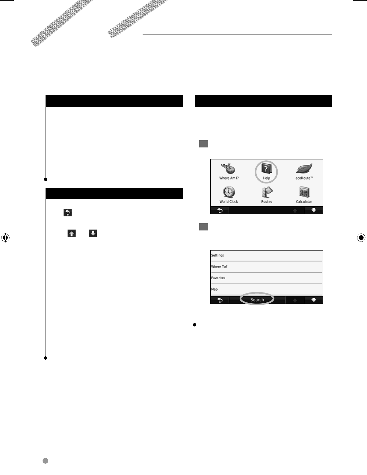
Touch To o ls > Help to get more information
about using your navigation system. Touch a
category to view information about a topic.
1 Touch Tools > Help.
2 To search the Help topics for a keyword,
touch Search.
⁄
• After your KNA unit is installed and connected to your
display unit, press the reset button on your display unit
before using the KNA unit for the first time.
• Several screens may appear on your display unit before it
recognizes your KNA unit.
8 GPS Navigation System Instruction Manual
 Loading...