

Page 1

ThankyouforpurchasinganINFINITIautomobile. This user’s manual is for the navigation
system only. This manual contains operating
instructionsfortheINFINITINavigation System
offered in the INFINITI Q45.
Pleaseread thismanualcarefully toensuresafe
operation of the navigation system.
O Please read your vehicle’s owner’s manual
first.
O Donotremove this manual fromthevehicle
when selling this vehicle. The next user of
this navigation system may need the
manual.
O Because of possible specificationchanges,
sections of this manual may not apply to
your vehicle.
O All information, specifications and illustra-
tionsinthis manualarethose ineffectatthe
time of printing. INFINITIreservesthe right
to change specifications or design at any
time without notice.
Page 2

Page 3

CONTENTS
INTRODUCTION .............................................................................. 1-1
HOW DOES THE INFINITI NAVIGATION SYSTEM WORK?............................ 2-1
WHAT FEATURES ARE AVAILABLE ON THE INFINITI NAVIGATION SYSTEM?.... 3-1
HOW DO I OPERATE THE INFINITI NAVIGATION SYSTEM?.......................... 4-1
HOW DO I PROGRAM A DESTINATION?................................................. 5-1
HOW DO I USE THE POINT OF INTEREST (POI) FEATURE? ......................... 6-1
HOW DO I USE THE ADDRESS BOOK FEATURE?...................................... 7-1
HOW DO I USE THE AVOID AREA FEATURE? .......................................... 8-1
HOW DO I USE THE AUTOMATIC REROUTING FEATURE?........................... 9-1
HOW DO I USE THE VOICE GUIDANCE FEATURE?................................... 10-1
HOW DO I ADJUST THE DISPLAY? ..................................................... 11-1
INFORMATION ON MAP DATA DISCS .................................................. 12-1
TROUBLESHOOTING GUIDE .............................................................. 13-1
INDEX ........................................................................................ 14-1
Page 4

Page 5

How to use this manual.............................. 1-2
For safe operation ................................. 1-2
Reference symbols................................. 1-2
Safety note................................................... 1-2
Laser product......................................... 1-3
1 INTRODUCTION
Page 6

INTRODUCTION
HOW TO USE THIS
MANUAL
Thismanualusesspecialwordsandicons,organized by function. Please refertothe following items and familiarize yourself with these
symbols.
FOR SAFE OPERATION
WARNING
This is used to indicate the presence
of a hazard that could cause death or
serious personal injury. To avoid or
reduce the risk, the procedures must
be followed precisely.
1-2
CAUTION
This is used to indicate the presence
of a hazard that couldcause minor or
moderate personal injury or damage
to your vehicle. To avoid or reduce
the risk, the procedures must be followed carefully.
NOTE:
Thisindicates anitemto helpyou under-
standthe maximum performanceof your
vehicle. If ignored,itmayleadtoa malfunction or poor performance.
REFERENCE SYMBOLS
INFO:
This indicates information necessary for effi-
cient use of your vehicle or accessories.
DEST button
This is a button on the control panel.
View key
Thisisaselect key on the screen.Byselecting this key you can proceed to the
next function.
SAFETY NOTE
This system is primarily designed to help you
reachyour destination,andalso performsother
functions as outlined in this manual. However,
you,thedriver, must use thesystemsafelyand
properly. Information concerning road conditions, traffic signs and the availability of services may not always beup-to-date.The sys-
tem is not a substitute for safe, proper,
and legal driving.
Before using the navigation system, please
read the following safety information. Always
use the system as outlined in this manual.
Page 7

WARNING
O
When the driver wants to operate
the navigation system or use the
joystick (screen function), first
park the vehicle in a safe place
and set the parking brake. Using
the system while driving can distract the driver and may result in
a serious accident. Destinations
cannot be set while the vehicle is
in motion.
O
Do not rely on voice guidance
alone.Always besurethat alldriving maneuvers may be made legally and safely to avoid accidents.
O
Do not disassemble or modify this
system. If you do, it may result in
accidents, fire, or electrical
shock.
O
Do not use this system if you notice any malfunctionsuchasafrozen screen or lack of sound. Continued use of the system may resultinaccidents, fire,orelectrical
shock.
O
If you notice any foreign object in
the system hardware or spilled
liquid, or notice smoke or a smell
comingfromit, stop using thesystem immediately and contact your
nearest INFINITI dealer. Ignoring
such conditions may lead to accidents, fire, or electrical shock.
NOTE:
Some states/provinces may have laws
limiting the use of video screens while
INTRODUCTION
driving. Use this system only where legal.
LASER PRODUCT
This navigation system is certified as a Class
I laser product.
The navigation system complies with DHHS
Laser-Radiator Standards, 21 CFR Chapter 1
subchapter J.
1-3
Page 8

Page 9

2 HOW DOES THE INFINITI NAVIGATION SYSTEM WORK?
What is a navigation system?..................... 2-2
About the navigation system ................ 2-2
What is GPS (Global Positioning
System)? .................................................... 2-2
Accuracy of positioning.......................... 2-2
Positioning adjustment........................... 2-3
Receiving signals from GPS satellites... 2-3
Display of GPS information................... 2-3
Detailed map coverage areas (MCA) for the
navigation system ....................................... 2-4
When a gray road is displayed on the
map ........................................................ 2-4
Page 10

HOW DOES THE INFINITI NAVIGATION SYSTEM WORK?
WHAT IS A NAVIGATION
SYSTEM?
ABOUT THE NAVIGATION SYSTEM
This navigation systemcombines the data obtained from the vehicle (by gyro sensor) and
from GPS (Global Positioning System) satellites to calculate thecurrentlocation of the vehicle. This position is then displayed on the
screen, allowing route guidance to a destination.
WHAT IS GPS (GLOBAL POSITIONING SYSTEM)?
GPSisa systemdevelopedand operatedbythe
U.S. Government, covering the entire planet.
This navigation system receives three or more
different radio signals from NAVSTAR (GPS
satellites), orbiting the earth 13,049 miles
(21,000 km) above ground. The data from different sets of signals will be trigonometrically
calculated to obtain the position of the vehicle.
2-2
INFO:
ThetrackingcenterintheU.S.controls signals
transmitted from GPS satellites. This control
sometimes results in reduced accuracy or no
signal received at all, in accordance with government requirements.
ACCURACY OF POSITIONING
INV1191
The color of the GPS Indicator on the upper left corner of the screen indicates positioning as follows:
O Green:positioningispossibleandaccurate
O Yellow: positioning is possible but accu-
racy is minimal
O Gray: positioning is not possible
Page 11

HOW DOES THE INFINITI NAVIGATION SYSTEM WORK?
INFO:
For approximately 3 or 4 minutes after system
startup, the GPS indicator
even if accurate positioning is possible.
remains gray,
POSITIONING ADJUSTMENT
When the system judges that the vehicle position information is not accurate based on vehicle speed and gyrosensor data calculations,
the system will adjust the vehicle position information using GPS signals.
RECEIVING SIGNALS FROM
GPS SATELLITES
Sometimes,satellitereception isweak.Thefollowing are places where signals tend to be
weak:
O Insidetunnelsandparking lots in buildings
O Areas with numerous tall buildings
O Under multi-layered highways
O In a dense forest
Vehicles in these areas may not receive GPS
signals (Indicator color: gray).
INFO:
TheantennaforGPS is located on the rearpar-
celshelfinsidethevehicle. Do not place any
objects, especially mobile phones or
transceivers, on the rear parcel shelf.
Because the strength of the GPS signal is approximately one billionth of that of TV waves;
phones and transceivers will decrease the
strength or may totally disrupt the signal.
DISPLAY OF GPS INFORMATION
This system displays GPS information.
Please refer to “GPS information display” on
page 11-13.
NOTE:
Directional guidance provided by the
navigationsystemdoesnot take carpool
lane driving into consideration, especially when carpool lanes are separated
from other road lanes.
2-3
Page 12

HOW DOES THE INFINITI NAVIGATION SYSTEM WORK?
DETAILED MAP COVERAGE
AREAS (MCA) FOR THE
NAVIGATION SYSTEM
Thissystemis designed to helpyoureachyour
destination, and also performs other functions
as outlined in this manual. However, you, the
driver, must use the system safely and properly. Information concerning road conditions,
trafficsignsand the availability ofservicesmay
not always be up-to-date. The system is not a
substitute for safe, proper, and legal driving.
Map data covers select metropolitan areas in
the United States.
Map data is available on map DVD-ROM. For
informationaboutmapDVD-ROMs,contactan
INFINITI dealer or call the INFINITI Navigation
System help desk at 1-800-662-6200 for U.S.,
and at 1-800-777-0325 for CANADA.
Map data includes 2 types of areas: “Detailed
coverage areas” providing all detailed road
2-4
data and other areas showing “Main roads
only”.
NOTE:
Detailed map data is not available in
many areas and is generally limited to
select major metropolitan areas.
For information on which metropolitan areas
are in detailed coverage areas, please refer to
the INFINITI Navigation System Software
Booklet(included).Whenyoupurchaseanupdated map DVD-ROM, a new software booklet
will be provided.
WHEN A GRAY ROAD IS DISPLAYED ON THE MAP
O Routecalculation maynotbepossiblewhen
a destination or the current vehicle location
is near a gray road.
O When setting a destination, the road near
the cross cursor blinks. For gray roads,
however, the road may not blink.
O When you are driving on a gray road after
thevehiclehas deviated fromthesuggested
route during route guidance, automatic rerouting may not start immediately.
O Route guidance (enlarged view and voice
guidance) may not bedone at the intersection where the road your vehicle is driving
on and a gray road intersect.
O POIinformationandstreetnamesneargray
roads are not contained in the map data.
Page 13

3 WHAT FEATURES ARE AVAILABLE ON THE INFINITI
NAVIGATION SYSTEM?
Route guidance............................................ 3-2
Point of interest (POI) directory ................ 3-2
Address book............................................... 3-2
Avoid area.................................................... 3-2
Automatic re-route ...................................... 3-3
Detour.......................................................... 3-3
TM
Birdview
Voice guidance............................................ 3-3
Short menus................................................ 3-4
................................................... 3-3
Page 14

WHAT FEATURES ARE AVAILABLE ON THE INFINITI NAVIGATION SYSTEM?
ROUTE GUIDANCE
The main feature of the INFINITI Navigation
System is Visual and Audio Route Guidance in
selecteddetailedmapcoverageareas.Utilizing
a network of GPS(Global Positioning System)
satellites, the INFINITI Navigation System
tracksyourlocation onthemap anddirectsyou
where you want to go.
Once you program a destination covered by a
detailed map, The INFINITI Navigation System
will determine a route from your current location to your destination. The moving map display and turn-by-turn voice commands help
the driver determine upcoming turns.
Thisfeaturecan be especiallyhelpfulinfinding
unfamiliarlocationsor businesses. Thesystem
may be unable to set a destination and/orcalculate distance when a destination is outside
adetailedmap coverage area. Additionally, audio route guidance may not be available if the
destination is outside adetailed map coverage
3-2
area. For more information on howtoprogram
a destination, please refer to section 5.
POINT OF INTEREST (POI)
DIRECTORY
The INFINITI Navigation System offers an extensive Point of Interest directory in detailed
map coverage areas. This directory includes a
wide variety of destinations ranging from gas
stations,ATMs, and restaurants to casinos, ski
resorts, shopping centers and businesses. By
accessing the Point of Interest directory, you
can search for addresses and phone numbers
for a destination, and with a press of a button,
the INFINITI Navigation System will calculate
a route to the destination.
The Point of Interest directory offers many
uses. For example,the directory can besorted
by the various types of restaurants near your
current location. If you need an ATM or gas
station, the INFINITI Navigation System can
point you to theclosest one or theclosest one
of your favorite brand.
For more information on how to use the Point
of Interest directory, please refer to section 6.
ADDRESS BOOK
Using the Address Book feature, you will have
theabilityto storeupto 50locationsin detailed
map coverage areas into a personal directory.
This is especially useful for frequently visited
locations, such as your clients, relatives, or
friends. The AddressBook feature will provide
you with easy access to frequently visited locations when setting them asyourdestination.
For more information on how to use your Address Book, please refer to section 7.
AVOID AREA
By using the Avoid Areafeature,youcan identify areas or freeways that you would like the
INFINITI Navigation System to avoid when
plotting routes. For example, if you know of a
Page 15
WHAT FEATURES ARE AVAILABLE ON THE INFINITI NAVIGATION SYSTEM?
freeway or area that is always congested with
traffic, you can program the INFINITI Navigation System to plot routes that go around that
particular freeway or area.
For more information on the Avoid Area feature, please refer to section 8.
AUTOMATIC RE-ROUTE
If you miss aturn while using theRoute Guidance feature, the INFINITI Navigation System
will automatically recalculate a new route to
your destination.
For more information on the Automatic ReRoute feature, please refer to section 9.
DETOUR
If you hear about a trafficaccidenton the radio
that is 4 miles (6 km) ahead of you and traffic
isbacking upfast,you canusethe Detourfunction to calculate an alternative route that will
help you avoid the gridlock causedbythe traffic accident. The INFINITI Navigation System
hastheabilitytofindanalternativerouteusing
secondaryroadsthat will return you to primary
roads after a specified number of miles.
For more information on the Detour feature,
please refer to section 9.
BIRDVIEW
TM
INV1192
The INFINITI Navigation System gives you a
choice of two map viewing styles, a normal
2-dimensional PLANVIEW map and the
3-dimensional BIRDVIEW
BIRDVIEW
TM
mapdepictsa geographic areaas
TM
map. The 3-D
seen from an elevated perspective, so you will
get a better feel for the route ahead.
TM
For more information on theBIRDVIEW
fea-
ture, please refer to section 11.
VOICE GUIDANCE
INV1193
Route guidance is executed using voice and
screen instruction. When the vehicle approaches an intersection where you need to
turn, the voice guidancetells you the direction
to take.
3-3
Page 16

WHAT FEATURES ARE AVAILABLE ON THE INFINITI NAVIGATION SYSTEM?
The system also has the following useful features:
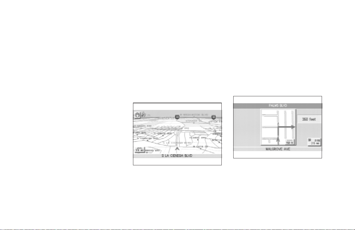
O Enlarged display of intersections.
O Automatic re-routing when a vehicle is off
the course (when map is displayed).
For more information on the Voice Guidance
feature, please refer to section 10.
SHORT MENUS
INV1194
Tomake theINFINITINavigation Systemeasier
to use, there is a shortmenufunction in which
3-4
the most commonly used items are listed.
When the indicator is illuminated, the short
menus (Easy Mode) are displayed. When the
indicator is turned off, the default navigation
systems menus (Expert Mode) are displayed.
INFO:
O [Easy Mode] is the default setting on the
initialscreenatthedeliveryof your new vehicle.
O [Expert Mode] is used inthis manual when
the
Short Menus key indicator is turned
off.When thegreenindicator ishighlighted,
the system is set to [Easy Mode].
O When the SETTING , DEST or
ROUTE button is pressed in the [Easy
Mode] screen, the
For more information on the Short Menu
feature, please refer to section 4.
Help key is displayed.
Page 17

4 HOW DO I OPERATE THE INFINITI NAVIGATION SYSTEM?
Control panel button functions .................. 4-2
Names of the components .................... 4-3
How to use the joystick and the enter
button..................................................... 4-3
How to use the PREV button .............. 4-4
How to use the CANCEL button.......... 4-4
How to use the SETTING button.......... 4-6
How to use the DEST button .............. 4-9
How to use the ROUTE button.......... 4-11
How to eject/insert the disc ..................... 4-13
Setting up the start-up screen.................. 4-14
Confirmation of destination or
waypoint............................................... 4-15
Clearing the memory................................. 4-17
Setting the average speed ........................ 4-18
About route guidance ................................ 4-19
Notes on route guidance...................... 4-20
About the display error........................ 4-21
Voice-activated control system (VACS) .... 4-22
Using the system ................................. 4-22
Voice command descriptions............... 4-23
Page 18
HOW DO I OPERATE THE INFINITI NAVIGATION SYSTEM?
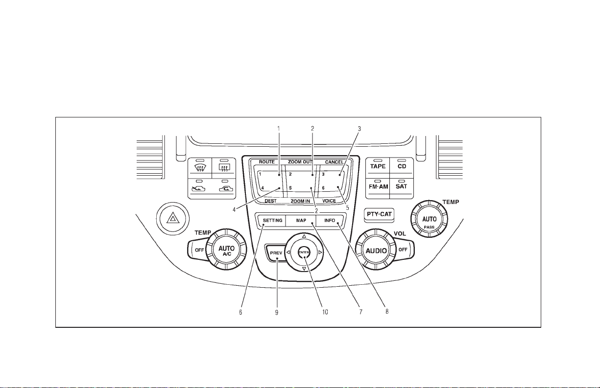
CONTROL PANEL BUTTON
FUNCTIONS
INI0080
4-2
Page 19
HOW DO I OPERATE THE INFINITI NAVIGATION SYSTEM?
NAMES OF THE COMPONENTS
1. ROUTE button; refer to page 4-11.
Displaysthe settingmenuscreenatthe time
of route calculation.
2. ZOOM OUT / ZOOM IN button; refer
to page 11-2.
Alters the scale of the map display.
3. CANCEL button; refer to page 4-4.
Cancels operations or route guidance.
4. DEST button; refer to page 4-9.
Displays the “Set a Destination” menu.
INI0081
5. VOICE button; refer to page 10-4.
Provides upcoming voice command from
the current location.
6. SETTING button; refer to page 4-6.
Performs various adjustments and settings
tohelpyouusethe navigation system more
effectively.
7. MAP button; refer to page 5-32.
Toggles between the intersection and the
map during route guidance. Returns to the
map screen from the settings screen.
8. INFO button; refer to page 5-39.
When fuel is low, it is possible to display
routes to the nearest fuel station.
9. PREV button; refer to page 4-4.
Returns to the previous screen during setup.
Finishes the set-up after it is completed.
10.JOYSTICK and ENTER button; refer to the
next section.
Scrolls the map,selects and sets each setting item.
11.
button
Ejects the DVD.
HOW TO USE THE JOYSTICK
AND THE ENTER BUTTON
Thenavigationsystemisoperatedbyselecting
keys on the screen with the joystick and pressing the ENTER button. Be sure to understand
4-3
Page 20
HOW DO I OPERATE THE INFINITI NAVIGATION SYSTEM?
the operation of the joystick before using the
navigation system.
Selecting the keys on the screen
Use the joystick to select keys on the screen.
The joystick can be tilted in eight directions.
The selected keywill be highlighted in yellow.
INFO:
Use the joystick to scroll the map.
Selecting the function of the
highlighted key
Press the ENTER button.
The display shows the screen to carry out the
functionoftheselected key (highlighted in yellow).
HOW TO USE THE
PREV
BUT-
TON
This button has two functions.
To return to the previous screen:
4-4
When this button is pressed during setup,
setup will be canceled, and the screen will return to the previous screen.
To finish the set-up:
When this button is pressed after set-up is
completed, the settings will be renewed as directed, and the screen will return to the map.
INFO:
Whenthe PREV button must bepressed,(for
example, after the set-up is finished) instructions are given in the operation procedure of
eachsectionin this manual. Ifthe PREV button is pressed when not finished with the setup, the setting will be canceled, and the screen
will return to the previous screen.
HOW TO USE THE
CANCEL
BUTTON
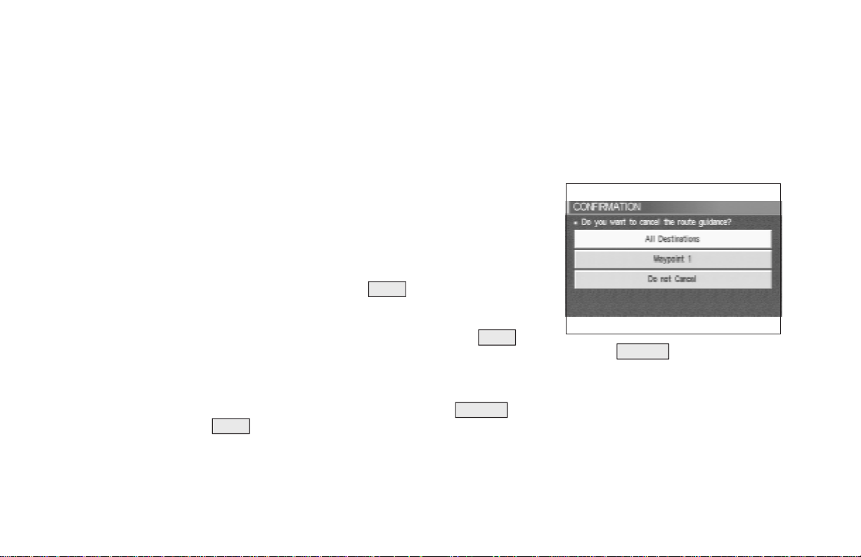
This button has two functions:
O Operation is canceledwhen pushed during
operation.
O The [CONFIRMATION] screen isdisplayed
during route guidance in the present location map.
INV1195
When the CANCEL button is pressed, the
[CONFIRMATION] screen is displayed withthe
following three keys.
O All Destinations
O Waypoint 1 or Waypoint
O Do not Cancel
Page 21
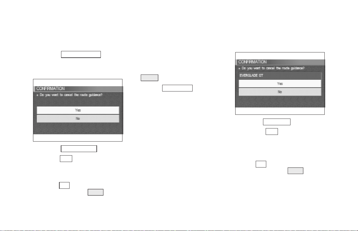
HOW DO I OPERATE THE INFINITI NAVIGATION SYSTEM?
When the
All Destinations
key is
selected
The route guidance is turned off temporarily.
INV1196
1. Select the
2. When the
guidance is turned off.
INFO:
O Whenthe
be displayed. When the PREV button is
All Destinations key.
Yes key is selected, the route
No key isselected,the mapwill
pressed, the previous screen will be displayed.
O To restart the route guidance, press the
VOICE button.
When the
Waypoint 1
key is se-
lected
INFO:
This key can be selected only when a waypoint
is set.
Routeguidancetothe next waypoint is deleted.
INV1197
1. Select the
2. When the
waypoint is deleted and route calculation
will start.
INFO:
When the
be displayed. When the PREV button is
pressed,thepreviousscreenwillbedisplayed.
Waypoint 1 key.
Yes key is selected, the
No key is selected, the map will
4-5
Page 22
HOW DO I OPERATE THE INFINITI NAVIGATION SYSTEM?
When the
Do not Cancel
key is
selected
The [Confirmation] screen will return to the
map screen.
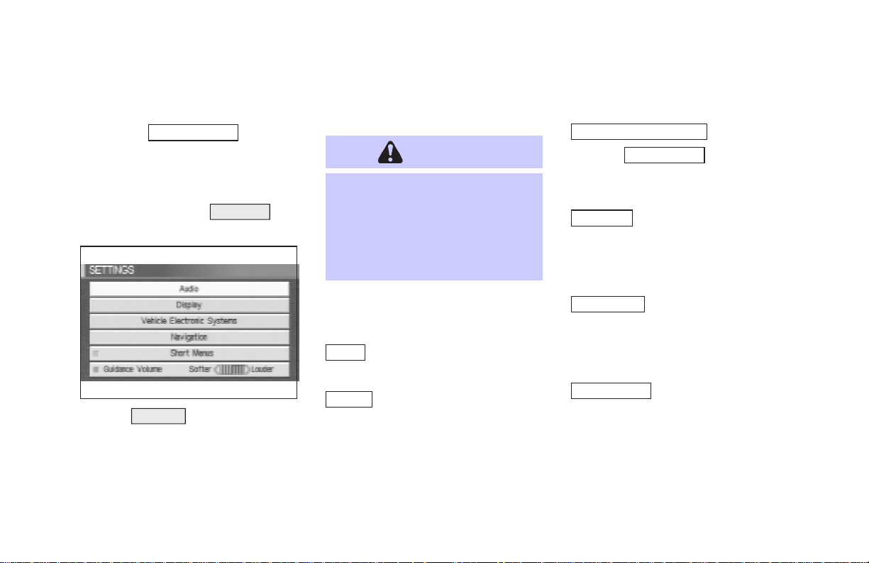
HOW TO USE THE
SETTING
BUTTON
INV1198
When the SETTING button is pressed, the
[SETTINGS] screen is displayed.
4-6
WARNING
For safety, some of the functions on
the menu will be disabled while the
vehicle is moving. To use the temporarilydisabledfunctions, park thevehicle in a safe place, shift to P or N,
and set the parking brake.
Tousethe navigation system more effectively,
various adjustments and settings can be performed.
Audio key:
Nosettingsavailable forthenavigationsystem.
Display key:
The key also adjusts the display
Brightness/Contrast/Map Background.
Please refer to page 11-16.
Vehicle Electronic System key:
When the
language and units change.
Please refer to page 4-7.
Navigation key:
Changes various settings of the navigation
system.
Please refer to page 4-8.
Short Menus key:
This key changes between [Expert Mode] and
[Easy Mode].
Please refer to 3-4.
Guide Volume key:
Adjusts or turns off volume of the voice guidance.
Pleaserefer to“Adjustingthe guidevolume”on
page 10-2.
Language/Unit key is selected,
Page 23
HOW DO I OPERATE THE INFINITI NAVIGATION SYSTEM?
Help key:
Available only in Easy Mode (Short menus).
You can see the explanation of navigational
functions.
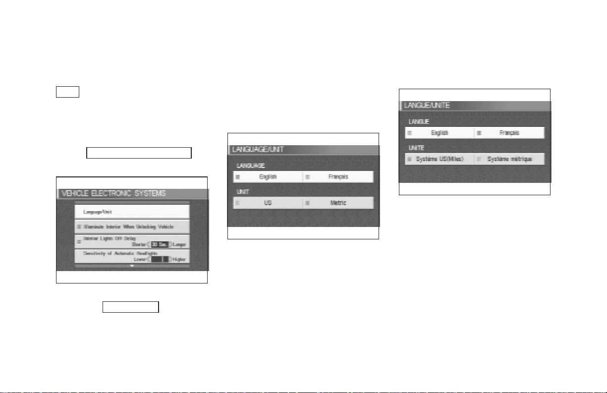
When
Vehicle Electronic System
key is selected
INV1278
1. The followingdisplay will appear when se-
lectingthe
ing ENTER button.
Language/Unit keyand press-
Language: English or French
Unit: US — Mile, MPG
Metric — km, /100 km
INV1280
2. You can select the language and unit using
the joystick and ENTER button.
INV1279
4-7
Page 24

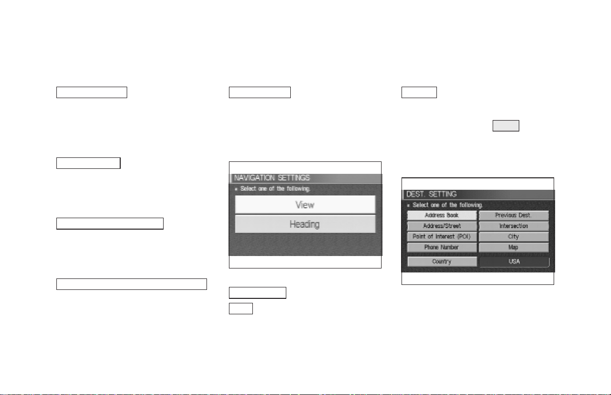
HOW DO I OPERATE THE INFINITI NAVIGATION SYSTEM?
When the
Navigation
key is se-
lected
INV1199
View key:
This will let you choose between Birdview
display and Planview display.
Please refer to “Switchingbetween Birdview
and Planview displays” on page 11-3.
Heading key:
You can set the map either to show the vehicle’scurrent forwarddirectionas up,orto show
North as up.
4-8
TM
TM
Please refer to “Changing the display direction
(in Planview display)” on page 11-7.
Nearby Display Icons key:
Displays five types of pointsofinterest around
the current location.
Please refer to “Setting the nearby display
icons” on page 6-13.
Save Current Location key:
Stores the current vehicle location in the address book.
Please refer to “Storing current vehicle position” on page 7-3.
Adjust Current Location key:
Corrects the location and direction of the vehicle icon.
Pleaserefer to“Updatingthe currentvehiclelocation and the direction” on page 11-14.
Auto Re-route On/Off key:
A new routeto the desired destination will automatically be calculated again from the location when the vehicle deviates from the suggested route during route guidance.
Please refer to “Automaticre-routing” on page
9-2.
Avoid Area Setting key:
Defines areas to avoid when calculating a
route.
Please refer to “Setting avoid areas” on page
8-2.
Clear Memory key:
Clears all the stored memory (Address Book,
Avoid Area, Previous Dest.).
Please refer to “Clearing thememory”onpage
4-17.
Page 25
HOW DO I OPERATE THE INFINITI NAVIGATION SYSTEM?
Edit Address Book key:
Changes the names and positions of the registered locations.
Please refer to “Setting up and editing the address book” on page 7-2.
GPS Information key:
GPS information will be displayed.
Please refer to “GPS information display” on
page 11-13.
Quick Stop Customer Setting key:
Sets the user-defined [Quick Stop] POI (Point
Of Interest).
Please refer to “Quick stop” on page 5-36.
Set Average Speed for Estimated Journey Time
key:
Please refer to “Setting the average speed” on
page 4-18.
Tracking On/Off key:
You can choose whether to display the path
from the start to the current position.
Please refer to “Displaying the track” on page
11-12.
INV1200
Easy Mode — when the
Short Menus
View key:
Same as in Expert Mode.
key is selected
Heading key:
Same as in Expert Mode.
HOW TO USE THE
DEST
BUT-
TON
Sets destinations (final destination and
waypoints) to search for a route.
INV1201
This will activate various navigational functions.
4-9
Page 26

HOW DO I OPERATE THE INFINITI NAVIGATION SYSTEM?
Address/Street key:
WARNING
For safety, some of the functions on
the menu will be disabled while the
vehicle is moving. To use the temporarilydisabledfunctions, park thevehicle in a safe place and shift to P or
N, and set the parking brake.
O Address Book key:
Use this category item if you want to go to
places stored in the address book.
Please refer to “Setting with the
Address Book key” on page 5-3.
O
Previous Dest. key:
You can choose destinations from the last 10
destinations set.
For details, please refer to “Setting with the
Previous Dest. key” on page 5-5.
O
Use this category item if you know the city
name, street name and house number of the
destination (waypoints).
Please refer to “Setting with the
Address/Street key” on page 5-6.
Intersection key:
O
Sets a destination using the intersection of 2
streets.
Please refer to “Settingwith the
key” on page 5-12.
Point of Interest (POI) key:
O
Use this category item if you want to go to a
restaurant, hotel, gas station or other facility.
Please refer to “Setting with the
Point of Interest (POI) key” on page 6-2.
O
City key:
Sets the destination (waypoint) on the map
Intersection
screen of the area around the input city.
Please refer to “Setting with the
page 5-18.
O
Use this category item when the destination
phone number is known.
Please refer to “Setting with the
Phone Number key” on page 5-22.
O
Use this category item if you want to choose
the place directly on the map display.
Pleasereferto “Setting with the
page 5-24.
O
Thiskey isusedto retrievealocation inanother
country when it is set as the destination
(waypoint).
Pleaserefer to“Settingwith the
on page 5-25.
City key” on
Phone Number key:
Map key:
Map key”on
Country key:
Country key”
4-10
Page 27
HOW DO I OPERATE THE INFINITI NAVIGATION SYSTEM?
INV1202 INV1203
Easy Mode — when the
Short Menus
Help key:
You can seetheexplanationof the navigational
functions.
Home key:
When you setyour home in the address book,
a route home will be calculated by selecting
this key.
If the home is not set beforehand, the setting
key is selected
mode will appear to input the home address.
ROUTE
Home key”
BUT-
Please refer to “Setting with the
on page 5-26.
Address/Street key:
Same as in Expert Mode.
Point of Interest (POI) key:
Same as in Expert Mode.
Country key:
Same as in Expert Mode.
HOW TO USE THE
TON
Whenthe ROUTE buttonispressedwhile the
current location is displayed on the screen, the
display shows the following keys.
INFO:
When no operations are executed after a few
seconds,thekeys will disappearautomatically.
Quick Stop key:
Selects the destination (waypoints) from a list
of 5 commonly used POI (Points of Interest).
Please refer to “Quick stop” on page 5-36.
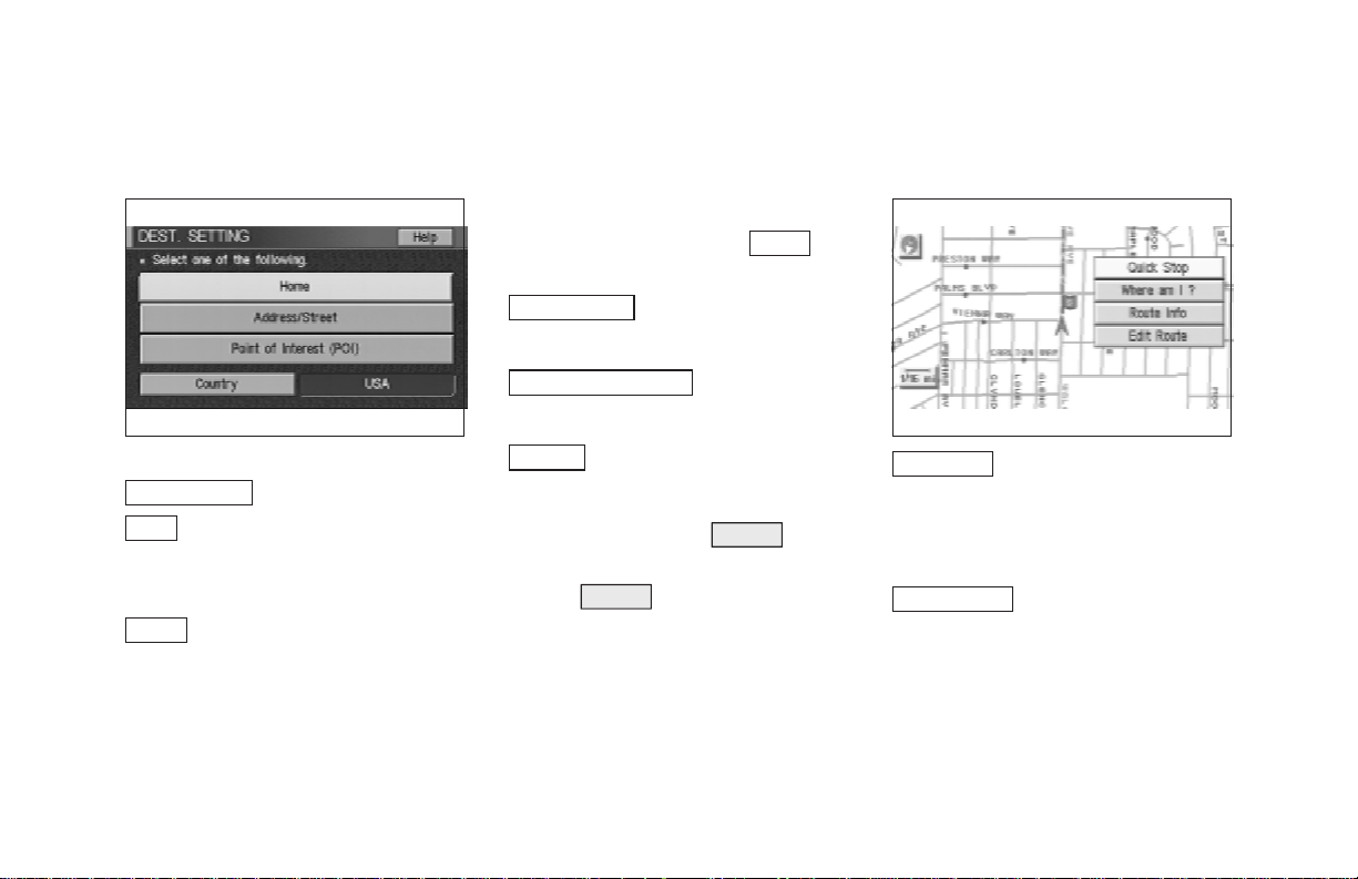
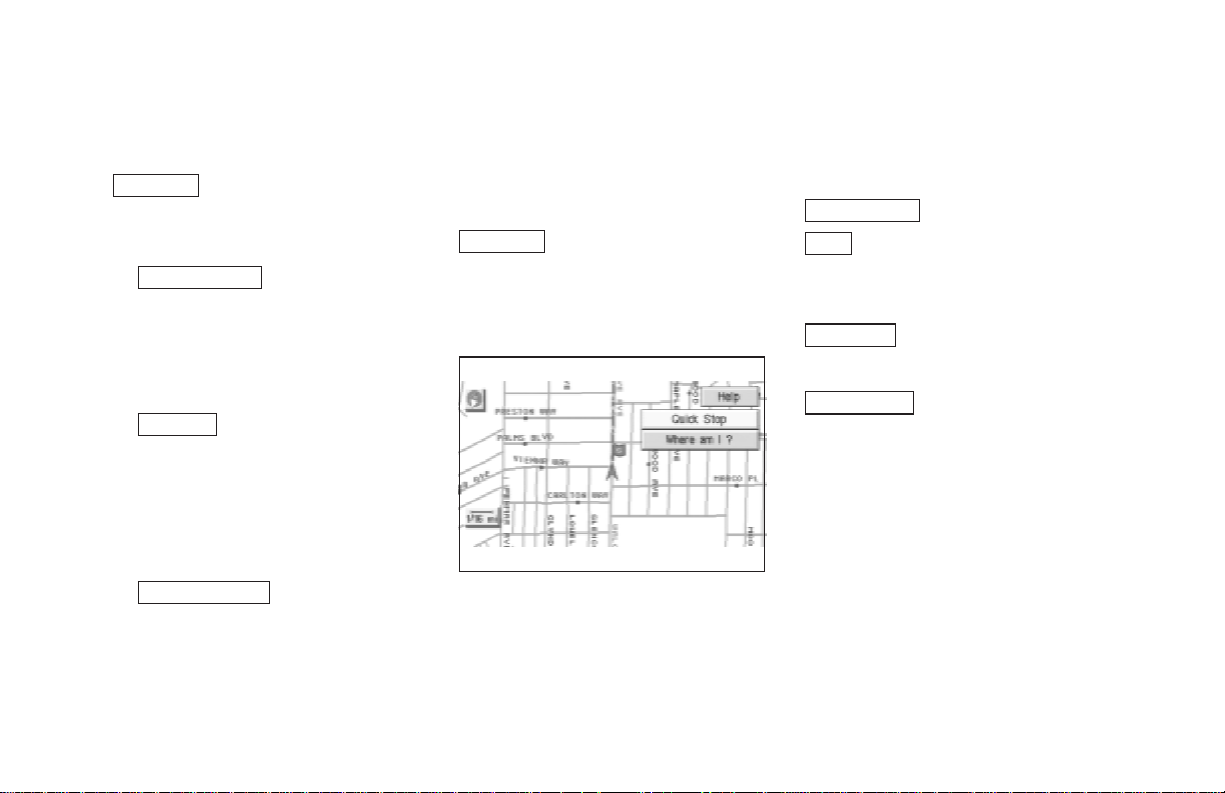
Where am I ? key:
Displays the street where the vehicle is currently located, the previous street, and the upcoming street.
Please refer to “Where am I” on page 5-40.
4-11
Page 28
HOW DO I OPERATE THE INFINITI NAVIGATION SYSTEM?
Route Info key:
Displays the route to the destination. There are
three types of display methods.
Complete Route key:
O
Displays the entire route from the current
location to the destination.
Please refer to “Displaying the complete
route to the destination” on page 11-9.
O
Turn List key:
Displaysalist oftheguidance points forthe
entire route to the destination on a simple
map.
Please refer to “Displaying turn list” on
page 11-10.
O
Route Simulation key:
Performs a simulation drive on the map
screen by moving a vehicle icon on all the
routes from the current locationto the destination.
4-12
Please refer to “Requesting the simulation
drive to the destination” on page 11-11.
Edit Route key:
Resets the set destination (waypoint).
Please refer to “Making the system guide the
route with detailed options” on page 5-27.
INV1204
Easy Mode — when the
Short Menus
Help key:
You can see the explanation of the navigation
functions.
Quick Stop key:
Same as in Expert Mode.
Where am I ? key:
Same as in Expert Mode.
key is selected
Keys that appear when the map
is scrolled with the joystick
You can scroll the map display and get informationaboutthe area nearyourvehicle and the
destination using the joystick.
INFO:
O Thisfunctioncan be used whentheoriginal
map disc is inserted.
Page 29
HOW DO I OPERATE THE INFINITI NAVIGATION SYSTEM?
O You can operate this with the map display
on.
O Thisfunctioncannotbeused when the sys-
tem is calculating the route or drawing the
screen.
INV1205
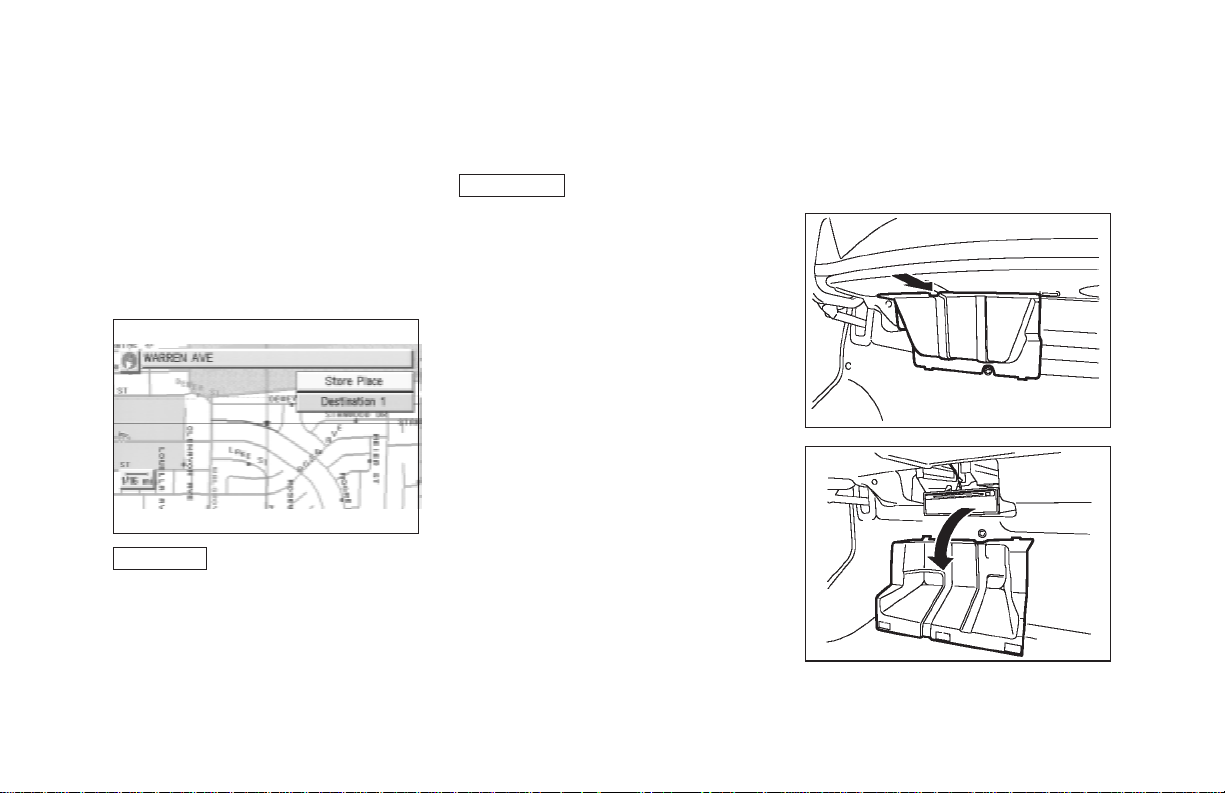
Store Place key:
You can store the location with the cross
pointer.
Please refer to “Storing current vehicle position” on page 7-3.
Destination # key:
You cansetthe position asadestination, using
the cross pointer. The maximum number of
destinations is six, andthelast one stored will
be the final destination. (# will appear on the
map to denote theselectedlocations from 1 to
6.) Please refer to “Making the system guide
the route with detailed options” on page 5-27.
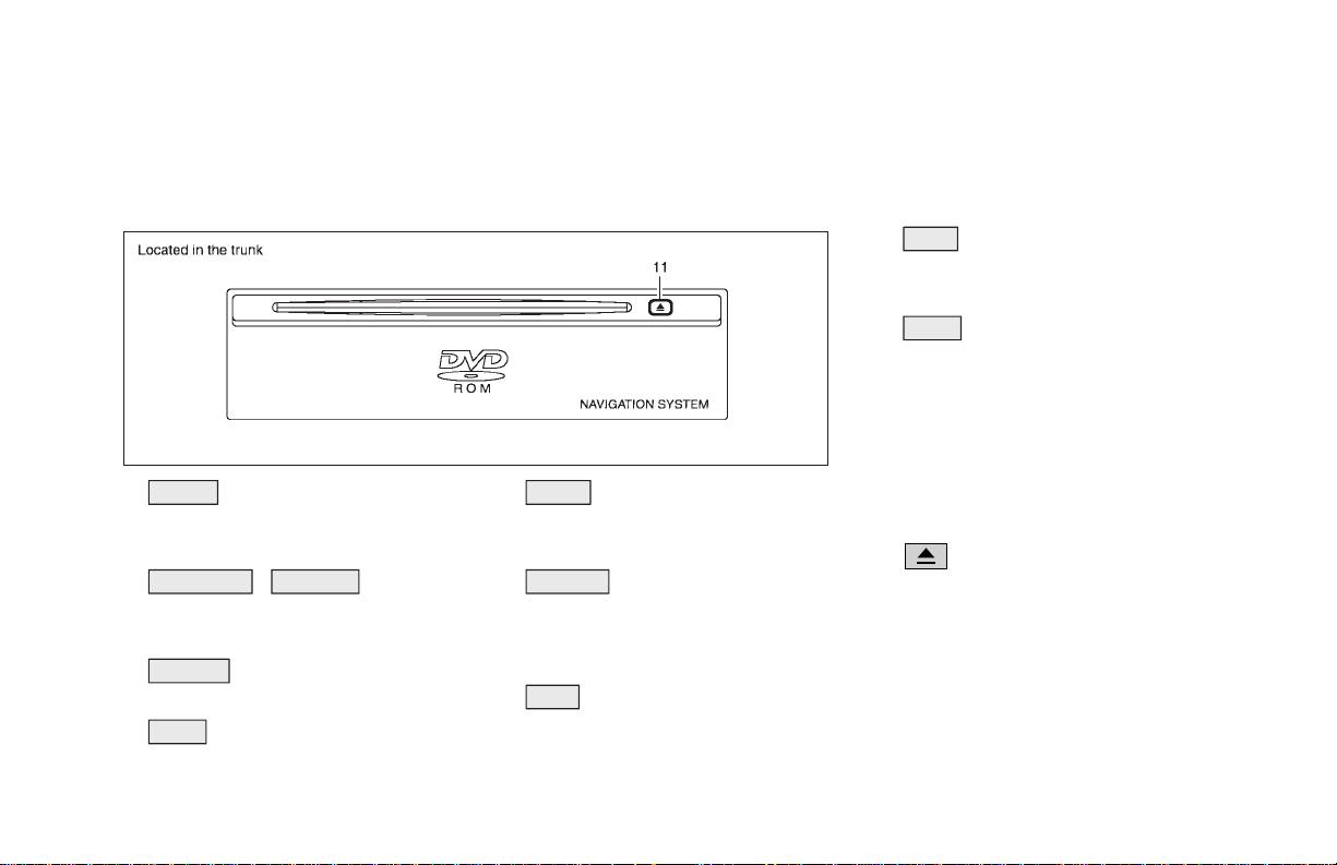
HOW TO EJECT/INSERT THE
DISC
INFO:
The navigation system is installed behind the
cover located on the upper left in the trunk.
This system is provided with the map DVD-
ROM.
NOTE:
Please take great care in handling the
disc.
1. Hook your finger in the notch of the navi-
gation system cover in the trunk.
INI0082
INI0083
2. Pull the cover toward you to open.
4-13
Page 30
HOW DO I OPERATE THE INFINITI NAVIGATION SYSTEM?
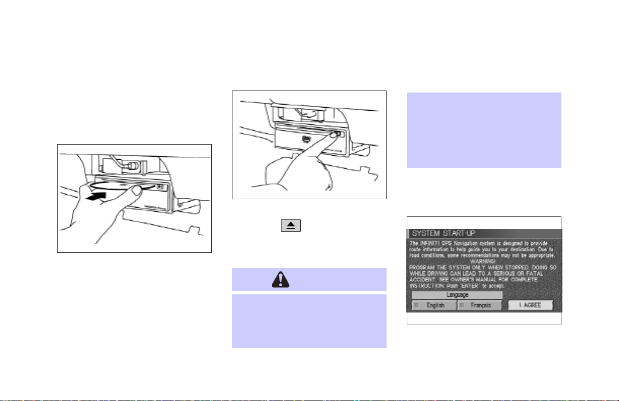
3. To insert a disc:
Place the disc in the slot.
Itwill bedrawninautomatically. You donot
have to push it in all the way.
O
malfunction.
Donot allowthesystem toget wet.
Excessive moisture such as
spilled liquids may causethe system to malfunction.
4-14
INI0051
To eject the disc:
Press the
disc.
4. Close the cover.
button, and remove the
CAUTION
O
Theincluded mapDVD-ROMis designed specifically for your navigation system. Do not use it in another system as it could cause a
INI0053
SETTING UP THE START-UP
SCREEN
INV1206
When you turn the ignition key to ACC, the
above warning is displayed on the screen. Ifit
Page 31

HOW DO I OPERATE THE INFINITI NAVIGATION SYSTEM?
is necessary to change language, selectoneof
the languages, then press the ENTER button.
Read the warning and select the
I AGREE (English) or ENTER (Franc¸ais)
key.
INFO:
If you do not pressthe ENTER button, the sys-
tem will not proceed to the next step display.
CONFIRMATION OF DESTINATION OR WAYPOINT
Whentheengineisturnedoffduringroutecalculation and then turned on, the [CONFIRMATION OF DEST./WAYPOINT] screen will be
displayed after the [SYSTEM START-UP]
screen.
INV1207
In the [CONFIRMATION OF DEST./
WAYPOINT]screen,thefollowing fourkeysare
displayed.
O To All Destinations
O From Next Waypoint
O Cancel Guidance
O Change (only in Expert Mode)
INFO:
Whenthe PREV or MAP button ispressed
inthisscreen,the[Turn by turn] screen will be
displayed.
When the
To All Destinations
key is
selected
Route guidance will start to all
destinations/waypoints from the current location.
When the
From Next Waypoint
key
is selected
INV1208
1. Select the From Next Waypoint key.
4-15
Page 32

HOW DO I OPERATE THE INFINITI NAVIGATION SYSTEM?
previous screen will be displayed.
Select the key when you want to start route
guidance to the next waypoint/destination.
INV1209
2. When the Yes keyisselected,routeguidance to the currentwaypoint is deleted and
routecalculationtothe next destination will
start.
INFO:
O If you do not want to delete the route guid-
ance, select the
No key and the screen
will return to the map.
O This key can be selected only when a
waypoint is set.
O When the PREV button is pressed, the
4-16
When the
Cancel Guidance
selected
The route guidance is canceled.
1. Select the
Cancel Guidance key.
key is
INV1210
INV1211
2. When the
Yes keyisselected, routeguid-
ance is canceled.
INFO:
O If you do not want to delete the route guid-
ance, select the
No key and the screen
will return to the map.
O Press the VOICE button to activate the
route guidance again.
O When the PREV button is pressed, the
previous screen will be displayed.
Page 33

HOW DO I OPERATE THE INFINITI NAVIGATION SYSTEM?
When the
Change
key is se-
lected
It is possible to edit the route guidance to the
destination.
INFO:
This key is displayed only in [Expert Mode].
INV1212
1. Select the
Change key.
INV1213 INV1214
2. The [EDITROUTE]screen willbedisplayed.
Pleasereferto“Settingthewaypoints”on page
5-28.
CLEARING THE MEMORY
All the stored data (AddressBook, Avoid Area,
Previous Dest) can be cleared.
1. Press the SETTING button.
2. Select the
[SETTINGS] screen.
Navigation key on the
INV1215
4-17
Page 34

HOW DO I OPERATE THE INFINITI NAVIGATION SYSTEM?
3. Select the Clear Memory key.
4. Select the
Yes key.
4-18
INV1216
INV1217
5. When the
Yes key is selected, the stored
data will be cleared,and the [NAVIGATION
SETTINGS] screen will appear.
SETTING THE AVERAGE
SPEED
This navigation system can calculate and display the expected arrival time to the destination. To do this, set average vehicle speeds
when driving onfreeways, main roads and ordinary roads.
The following settings are available.
O Freeway
Default: 55 MPH (90 km/h)
Max: 70 MPH (110 km/h)
Min: 40 MPH (60 km/h)
O Main Roads
Default: 25 MPH (40 km/h)
Max: 50 MPH (80 km/h)
Min: 10 MPH (20 km/h)
O Others
Default: 15 MPH (25 km/h)
Max: 35 MPH (55 km/h)
Min: 5 MPH (10 km/h)
1. Press the SETTING button.
2. Select the
Navigation key on the [SET-
TING] screen.
INV1214
Page 35

3. Select the
Set Average Speed for Estimated Journey Time
key on the [NAVIGATION SETTINGS]
screen.
HOW DO I OPERATE THE INFINITI NAVIGATION SYSTEM?
ABOUT ROUTE GUIDANCE
O The INFINITI Navigation System may not
calculate routes longer than about 1,100
miles (1,770 km). If your trip is longer than
1,100 miles (1,770 km), please divide your
trip by selecting one or two intermediate
destinations. Set your destination as the
first intermediate destination. Once you
INV1218 INV1219
4. Move the joystick upward or downward to
select an item you want to change.
5. Move the joystick left or right and set an
average vehicle speed.
INFO:
O It is possible to set the item illuminated in
yellow.
O When the
keyisselected, all settingsreturnto default.
Return All Settings to Default
pass the intermediatedestination, you may
set your final destination as your destination if it is within 1,100 miles (1,770 km).
Otherwise, set your destination using your
second intermediate destination.
NOTE:
The navigation system does not take
driving in “Carpool lanes” into consideration for the guidance, especially
when carpool lanes are separated from
other road lanes.
4-19
Page 36

HOW DO I OPERATE THE INFINITI NAVIGATION SYSTEM?
NOTES ON ROUTE GUIDANCE
O The route selected by the system may not
betheshortest, norareother circumstances
such as traffic jams considered.
O Because of the inevitable differencein road
conditions and circumstances between the
time you use this system and the time the
information was produced for the DVD,
there may be discrepancies in roads and
regulations.Insuch cases, followtheactual
information available.
O During route calculation, the map will not
scroll, however the vehicle icon will move
with the actual vehicle’s movement.
O During route calculation, buttons such as
MAP , DEST , ZOOM OUT and
ZOOM IN and the joystick will be dis-
abled.
O Insomecases,afterthecalculationiscom-
plete, it may take some time to get the calculated route on the display.
4-20
O Waypoints that have been passed will not
be covered by the re-routing calculation.
O If you scroll the map while the suggested
route is being drawn, it may take more time
to finish drawing.
O If waypoints are set, thesystem is calculat-
ing multiple routes between waypoints simultaneously, andthefollowingmayresult.
—If one section (or more) of the routes be-
tween the waypoints is not found, none of
the route will be displayed.
—The route may not connect completely at
some waypoints.
—The route may require a U-turn close to
some waypoints.
O Route calculation may not be completed in
the following cases.
—If there is no main road within a range of
1.5 miles (2.5 km) from the vehicle, a message saying so will appear on the screen.
Try requesting route calculation when the
vehicle is closer to the main road.
—If there is no main road within a range of
1.5 miles (2.5 km) from the destination or
waypoint, a message saying so will appear
on the screen. Try setting the location
closer to the main road.
—If the vehicle is tooclose to the destination
or if there are no branches of the roads to
the destination. A message saying so will
appear on the screen.
—Ifitis deemed impossible to reach the des-
tination or waypoints because of traffic
regulations, etc.
—If the only route to reach the destination or
waypoints is extremely complicated.
—If the destination, current vehicle position
or waypoint is within the “avoid area”.
—If the setting of “avoid areas” covers the
routes to the destination, route calculation
Page 37

HOW DO I OPERATE THE INFINITI NAVIGATION SYSTEM?
may not be possible.
O The following may occur when the route is
being displayed.
—If you are requestinga calculation from the
main road, the origin of the route may not
exactly match the current vehicle position.
—Ifyouare requesting a calculation to a des-
tination on the main road, the end of the
routemay notexactlymatchthedestination.
—If you are requestinga calculation from the
main road, the system may show a route
from another main road. This may be because the icon to show the current vehicle
position(vehicleicon) is notsetaccurately.
Inthatcase,parkthecarinasafeplace and
reset the vehicle icon, or continue driving
to see if the vehicle icon appears on the
main road before requesting route calculation again.
—Thereare cases in which the system shows
a detoured route to reach the destinationor
waypoints, if you set themfrom memory or
facility information. In order tocorrect this,
you will have to be careful about the traffic
direction, especially when the lanes with
different travel directions are shown separately. Such places are interchanges and
service areas.
—This system makes no distinction between
limited traffic control and total control
(blockage). It may show a detoured route
even if the road is usable.
—Evenif the freeway preferenceisset to OFF,
theroutemay be setonthem. Toavoidthis,
setawaypointonanotherroadtypeandrequest calculation.
—Even if the preference is set to OFF for a
ferry line, the route may be set on it. To
avoid this, set a waypoint on a road and request calculation.
—Ferrylines, except those whichaccept only
pedestrians, bicycles and motorcycles, are
stored in this system. When using them,
take into consideration the travel time required and operational condition to decide
whether to use them or not.
ABOUT THE DISPLAY ERROR
The following cases may affect the display accuracy of the vehicle’sposition or travel direction. The accuracy will return to normal if the
driving conditions return to normal.
—When there is a similar road nearby.
—When the vehicle is traveling on a long
stretch of straight road or series of curves
with a large radius.
—Whenthe vehicle istravelingin anareawith
a grid road system.
—When the vehicle is making consecutive S
curves.
—When the vehicle is at a large Y-shaped
junction.
4-21
Page 38

HOW DO I OPERATE THE INFINITI NAVIGATION SYSTEM?
—When the vehicle is on a loop bridge.
—When the vehicle is on a snow-covered or
unpaved road.
—When the vehicle has made several con-
secutive turns or traveled zigzag.
—Whenthevehicleisrotatedonaparkinglot
turntable while the ignition switch is OFF.
—Immediately after the vehicle is driven out
ofaparking garage orundergroundparking
lot.
—Whenthevehicle has different sizes of tires
or tire chains.
—Whenthe vehicle is moved immediately af-
ter the engine is started.
4-22
VOICE-ACTIVATED CONTROL SYSTEM (VACS) (if so
equipped)
The VACS (Voice-Activated Control System)
provides a safe and convenient way of controlling vehicle systems such as the phone, audio,
climate control and navigation system. The
system is controlled by the PTT (Push to
talk)button.Voicecommandsare picked up by
a microphone. When giving a command, voice
feedback will be heard through the speaker,
and messages will be shown on the display.
Voice feedback can be turned off if necessary.
Personal directories of nametags for phone dialing and radio station presets can be created,
and spoken command help is provided.
For details, please refer to the vehicle Owner’s
Manual.
USING THE SYSTEM
Initialization
When the ignition switch is turned to the ON
position, the initialization of thesystem is carried out, which takes a few seconds. When
complete, the system is ready to accept voice
commands. If the buttonis pressed before initializationiscomplete,themessage center display will show “VOICE NOT READY”.
Operating tips
To get the best results from the system, observe the following:
O Close the window before operating the
voice-activatedcontrol system(VACS).The
voice-activated control system may not be
able to recognize voice commands due to
surroundingnoises(travelnoiseandvibration). Be sure to operate the system when
the vehicle interior is quiet. While the PTT
buttonispushedwith the automatic climate
control system fan speed on level 4 or 5,
Page 39

HOW DO I OPERATE THE INFINITI NAVIGATION SYSTEM?
the fan speed is lowered down to level 3.
O After pressing the PTT button, always
wait for the beep before speaking.
O Speak in a natural voice without pausing
between words.
Giving voice commands
1. Turn the ignition switch totheONposition.
2. Push an instant PTT (Push to talk)button
on the steering wheel.
SIH0117
3. The beep will sound.
If the system is processing a command
or the phone is being used, an error
beep will sound and a message such as
“COMMANDCANCELED”, or “ASSISTIN
USE”, will be displayed.
4. If the VACS is activated, “LISTENING” will
be displayed on the screen.
5. Say a command*.
*: Refer tothe command listlater in thissec-
tion.
O Ifyoudo not speakacommand within
5 seconds, the beep will sound and
“NO SPEECH DETECTED” will be displayed on the screen.
O To cancel the command, press the
PTT button during feedback. The
“COMMAND CANCELED” will be displayed on the screen and finish.
6. If a command is activated,aural and visual
feedback will be provided.
7. To skip the aural-feedbackfora command,
press the PTT button during feedback.
VOICE COMMAND DESCRIPTIONS
In the command descriptions, optional words
are shown in square brackets [ ].
General commands
O [VOICE] FEEDBACK ON/OFF
Turns voice feedback successively on and
off.
O VOICE DELETE MEMORY A/B
Deletes the trained voice stored in memory
AorB.
O VOICE [PLAY] DIRECTORY
Lists the personal nametags stored with
each memory location.
O VOICE DELETE DIRECTORY
Deletes the personal nametag stored with
each memory location.
4-23
Page 40

HOW DO I OPERATE THE INFINITI NAVIGATION SYSTEM?
Dialog commands
O YES/NO
Confirms a command after the prompt
“Please say YES or NO”.
O CANCEL
Cancels a command after the prompt
“Please say YES, NO or CANCEL”.
O CORRECT/CORRECTION
To clear the lastgroup of numbers entered
when using the phone enter command.
O STORE
Tostorethephonenumber,saySTOREafter entering the phone number.
Help commands
O HELP
Gives spoken information about the voice
activation system.
O HELP DIRECTORY
Gives spoken information about the directory voice commands.
4-24
O HELP RADIO
Gives spoken information about the radio
voice commands.
O HELP RADIO MEMORY
Gives spoken information about the radio
memory commands.
O HELP TAPE/CASSETTE
Gives spoken information about the cassette tape voice commands.
Example:
• HELP TAPE
• HELP CASSETTE
O HELP CD [CHANGER/DJ]
Gives spoken information about the CD
player voice commands.
O HELP AUDIO
Gives spoken information about the audio
voice commands.
O HELP PHONE/TELEPHONE
Gives spoken information about the phone
voice commands.
O HELP PHONE/TELEPHONE MEMORY
Gives spoken information about the telephone memory commands.
O HELP CLIMATE [CONTROL]
Givesspokeninformationabouttheclimate
control voice commands.
O HELP DISPLAY
Givesspokeninformationaboutthedisplay
commands.
O HELP VOICE MEMORY
Gives spoken information about the voice
memory commands.
O HELP NAVIGATION
Gives spoken information about the navigation commands.
Page 41

HOW DO I OPERATE THE INFINITI NAVIGATION SYSTEM?
Navigation commands
O NAVIGATION [ON]
Turns map on.
O ZOOM IN
Alters the scale of map display.
O ZOOM OUT
Alters the scale of map display.
O BIRD VIEW
Switches to BIRDVIEW display.
O PLAN VIEW
Switches to PLANVIEW display.
O HERE FUNCTION
Displays the street on which the vehicle is
currently located, the previous street and
the upcoming street.
O HOME
Sets HOME as the destination.
O SAVE CURRENT LOCATION
Storescurrentvehicles position inthenavi-
gation computer memory.
O [SHOW] NORTH UP
Changes the display direction.
O [SHOW] HEADING UP
Changes the display direction.
O INTERSECTION MAP
Shows the intersection map.
O REPEAT [VOICE GUIDANCE]
Repeats the voice guidance.
O ROUTE GUIDANCE CANCEL
Turns route guidance off.
O ROUTE GUIDANCE ON
Turns route guidance on.
O VOICE MUTE
Turns the guidance volume off.
O VOICE MUTE OFF
Turns the guidance volume on.
O SOFTER
Decreases the voice guidance volume by 1
step.
O LOUDER
Increases the voice guidance volume by 1
step.
O PREVIOUS
Returns to the previous screen.
4-25
Page 42

Page 43

5 HOW DO I PROGRAM A DESTINATION?
Various ways to set the destination (or
waypoint)..................................................... 5-2
Expert mode categories......................... 5-2
Easy mode categories............................ 5-2
Setting with the
Setting with the
Setting with the
Setting with the
Setting with the
key........................................................ 5-18
Setting with the
Setting with the
key........................................................ 5-22
Setting with the
Setting with the
Address Book key ... 5-3
Previous Dest. key ... 5-5
Address/Street key... 5-6
Intersection key...... 5-12
Point of Interest (POI)
City key.................. 5-18
Phone Number
Map key ................ 5-24
Country key .......... 5-25
Setting with the
Having the system guide you to the
destinations ............................................... 5-27
Making the system guide the route with
detailed options.................................... 5-27
Adjusting and deleting the preset destination
(waypoints)................................................ 5-33
To delete a destination ....................... 5-34
All clear...................................................... 5-35
Quick stop.................................................. 5-36
Quick stop customer setting................ 5-38
Route guidance to a fuel station when fuel
is low.................................................... 5-39
Where am I?.............................................. 5-40
Home key............... 5-26
Page 44

HOW DO I PROGRAM A DESTINATION?
VARIOUS WAYS TO SET
THE DESTINATION (OR
WAYPOINT)
WARNING
To operate the navigation system or
to use the screen functions, first park
thevehicleina safe place andsetthe
parking brake. Using the system
while driving can distract the driver
and may result in aserious accident.
5-2
INV1201
EXPERT MODE CATEGORIES
To set the destination and waypoints, you can
choosefromthe eight categories describedbelow. Use theseoptions to choose thebest way
to find the route to the destinations and
waypoints.
O Address Book
O Previous Dest.
O Address/Street
O Intersection
O Point of Interest (POI)
O City
O Phone Number
O Map
INV1202
EASY MODE CATEGORIES
When the Expert Mode is canceled, the following three categories will be displayed as Easy
Mode.
O Home
O Address/Street
Page 45

HOW DO I PROGRAM A DESTINATION?
O Point of Interest (POI)
INFO:
O Use the
Point of Interest (POI) key in the same
way as in Expert Mode.
Please refer to “Setting with the
Address Book key” on page 5-3 and
“Setting with the
key” on page 6-2.
O If the
green in the [SETTING] screen, the screen
is in Easy Mode.In this case, the keysdisplayed are different from the screen in Expert Mode.
O If you set a destination or waypoints, they
will be displayed with icons.
O If you want to go to places close to the
storedlocationsorfacilities,usecategories
such as facility, nearby facility or memory
for easier setting.
Address Book key and the
Point of Interest (POI)
Short Menus key is highlighted in
O When using either the Point of Interest
(POI) or nearby Points of Interest categories, the names called up can be set as the
destination if you do not scroll the screen.
If you want to choose a different place on
the screen from the one called up, you will
have to scroll the screen.
SETTING WITH THE
Address Book
KEY
The Address Book will allow you to store locationsin thememory.Thisisespeciallyuseful
for locations that you visit frequently.
Please refer to “Setting up and editing the address book” on page 7-2.
INV1201
1. Press the DEST button.
2. Select the
[DEST. SETTING] screen.
The [DEST. SETTING (Address Book)] screen
will be displayed.
Address Book key on the
5-3
Page 46

HOW DO I PROGRAM A DESTINATION?
INV1220 INV1221 INV1222
3. Select the item key of your destination
(waypoints) on the [DEST. SETTING (Address Book)] screen.
5-4
4. To set the destination (waypoints), refer to
“Making the system guide the route with
detailed options” on page 5-27.
5. To slightly alter the destination.
Select the
screenofthe area around thespecifieddestination (waypoints).
Map key to display the map
Page 47

HOW DO I PROGRAM A DESTINATION?
INV1223
6. If necessary, operate the joystick to adjust
the location of the destination (waypoint).
Press the ENTER button. Select the
Destination key to confirm. The
[DEST.SETTING]screen will be displayed.
To set the destination (waypoint), refer to
“Making the system guide the route with
detailed options” on page 5-27.
INFO:
To change the listing order, select the
Sort
key on the [DEST. SETTING (Address Book)]
screen and tilt the joystick to the right or left,
or press the ENTER button.
Please refer to “Changingthe listing order” on
page 7-6.
SETTING WITH THE
Previous Dest.
KEY
Thissystem memorizesthelast 10destinations
previously chosen, allowing you to set new
destinations and waypoints from them.
INV1224
1. Press the DEST button.
2. Select the
Previous Dest. key on the
[DEST. SETTING] screen.
A total of 10 destinations and locations previously set will be displayed.
INV1225
3. Select the item key of your destination
(waypoints) on the [DEST. SETTING (Previous Dest.)] screen.
5-5
Page 48

HOW DO I PROGRAM A DESTINATION?
INV1226 INV1227 INV1228
4. To set the destination (waypoints), refer to
“Making the system guide the route with
detailed options” on page 5-27.
5-6
5. To slightly alter the destination.
Select the
screenofthe area around thespecifieddestination (waypoints).
Map key to display the map
6. If necessary, operate the joystick to adjust
the location of the destination (waypoints).
Press the ENTER button. Select the
Destination key to confirm. The
[DEST.SETTING]screen will be displayed.
To set the destination (waypoints), refer to
“Making the system guide the route with
detailed options” on page 5-27.
SETTING WITH THE
Address/Street
KEY
Setsthedestination (waypoints) from thestreet
names and addresses that you enter.
Page 49

Therearetwosearch methods; direct search by
the street names, and search by the street
names after the state/province and/or the city
are defined.
HOW DO I PROGRAM A DESTINATION?
INV1230 INV1231
1. First press the DEST button.
2. Select the
Address/Street key.
INV1229
Setting with the
The List key is used when you know the
names of the destination and waypoints.
1. A keyboard will be displayed on the[DEST.
SETTING (Address/Street)] screen. Enter
the street name you want to set.
INFO:
It is not possible toenter names if they are not
stored in the DVD-ROM.
List
key
2. Enter the street name of your destination.
For example, enter
3. Enter
U , then select the List key.
The list screen of street names which begin
TU will appear.
with
T , then U.
5-7
Page 50

HOW DO I PROGRAM A DESTINATION?
INV1232
O Iflessthan 5 suggestedstreetsremain, they
will be displayed automatically without selecting the
List key.
O The city names and street names will be
displayed.
O Use the joystick to scroll the display.
O When the
Next Search key is selected, it
is possible to narrow down cities. To use
this function, refer to “Setting with the
City key” on page 5-11.
O When the PREV button is pressed, the
5-8
screen to input street names will be displayed.
4. Select one street of your destination.
INV1233
5. Enter the house number.
Select the
OK key.
INFO:
Itmaynot bepossibleto specifyalocation after
selecting the
OK key. In that case, a list of
locations which correspond to the entered
house number will be displayed.
NOTE:
Ifahouse number isentered and itisnot
a“directhit” for housenumbers already
stored in the database, then only a map
to the general vicinity will be displayed.
INV1234
6. To set the destination (waypoints), refer to
“Making the system guide the route with
detailed options” on page 5-27.
Page 51

HOW DO I PROGRAM A DESTINATION?
actual location. Inthat case, correct the location using the joystick.
INV1235
7. To slightly alter the destination.
Select the
Map key to display the map
screenofthe area around thespecifieddestination (waypoints).
INFO:
O An approximate location corresponding to
the house number entered is displayed. If
necessary, correct the location using the
joystick.
O The location displayed by the calculation
usingthehouse number maydifferfrom the
INV1236
8. If necessary, operate the joystick to adjust
the location of the destination (waypoint).
Press the ENTER button. Select the
Destination key to confirm. The
[DEST.SETTINGS (Address/Street)]screen
will be displayed.
To set the destination (waypoint), refer to
“Making the system guide the route with
detailed options” on page 5-27.
INV1237
Setting with the
State
key
The State key is used when you select a
state/province to set the destination.
1. Select the
State key.
5-9
Page 52

HOW DO I PROGRAM A DESTINATION?
INV1238 INV1239 INV1240
2. The display shows the screen to select
states/provinces.
Input a state/province name.
5-10
INFO:
When the
step 2, the historyof the previous five settings
will be listed.
Last 5 States key is selected in
3. The display shows the state/province list.
Select a state/province name.
Page 53

HOW DO I PROGRAM A DESTINATION?
INV1241 INV1242 INV1243
4. The screen returns to the [DEST. SETTING
(Address/Street)] screen.
When the state/province is set, the display
shows the selected state/province next to
State key.
the
Input the street name.
Please refer to “Setting with the
on page 5-7.
List key”
Setting with the
The City key is used when you select a city
to set the destination.
1. Select the
O The display shows the screen to select cit-
ies.
City key.
City
key
2. Input a city name.
INV1244
5-11
Page 54

HOW DO I PROGRAM A DESTINATION?
INFO:
O Whenthe
Last5Cities key is selectedin
step 2, the history of the previous five settings will be listed.
O It is not possible to select cities if they are
not in the state/province you set.
INV1245
3. The display shows the city list.
Select a city of your choice.
5-12
INV1246
4. The screen returns to the [DEST. SETTING
(Address/Street)] screen.
When the city is set, the display shows the
selected city beside the
City key.
Input the street name of your choice.
Proceed to “Setting with the
List key” on
page 5-7.
SETTING WITH THE
Intersection
KEY
This will allow you to set an intersection as a
destination (waypoints).
INV1247
1. Press the DEST button.
2. Select the
A keyboard will be displayed.
Intersection key.
Page 55

HOW DO I PROGRAM A DESTINATION?
INV1248 INV1249
O When entering a street name, enter aminor
street name as the first street and the calculation will be easier and quicker.
Setting with the
The List key is used when you know the
names of the destinations and waypoints.
1. Enter the first street name where the destination (waypoints) is located using the
keyboard, then select the
List
key
List key.
2. Select the name of the first street.
INFO:
O When the
is possible to narrow down
states/provinces and cities. To use this
function, refer to “Setting with the
key” on page 5-17.
O For a roadwhere lanes with different traffic
directions are shown separately, the list
shows first street name, second street
name, ...
Next Search key is selected, it
City
INV1250
3. Enter the second (intersecting) street name,
then select the
INFO:
If there are less than 5 streets which intersect
the first street, they will be displayed automatically without selecting the
List key.
List key.
5-13
Page 56

HOW DO I PROGRAM A DESTINATION?
INV1251 INV1252 INV1253
4. Select the name of the second street.
The [DEST. SETTING (Intersection)] screen
will appear.
5-14
5. To set the destination (waypoints), refer to
“Making the system guide the route with
detailed options” on page 5-27.
6. To slightly alter the destination.
Select the
screenofthe area around thespecifieddestination (waypoints).
Map key to display the map
Page 57

HOW DO I PROGRAM A DESTINATION?
street name list may not be displayed:
O A street name is being input afterthe
City key has been selected.
O The list is being displayed by selec-
tion of the
List key.
INV1254
7. If necessary, operate the joystick to adjust
the location of the destination (waypoint).
Press the ENTER button. Select the
Destination key to confirm. The
[DEST. SETTINGS (Intersection)] screen
will be displayed.
To set the destination (waypoint), refer to
“Making the system guide the route with
detailed options” on page 5-27.
NOTE:
When the corresponding data does not
existunderthefollowing conditions, the
INV1255
Setting with the
State
key
The State key is used when you select a
state/province to set the destination.
1. Select the
State key.
INV1256
2. The display shows the screen to select
states/provinces.
Input a state/province name.
5-15
Page 58

HOW DO I PROGRAM A DESTINATION?
INV1257 INV1258 INV1259
INFO:
When the
step 2, the historyof the previous five settings
will be listed.
5-16
Last 5 States key is selected in
3. The display shows the state/province list.
Select a state/province name.
4. The screen returns to the [DEST. SETTING
(Intersection)] screen.
When the state/province is set, the display
shows the selected state/province next to
State key.
the
Input the street name.
Please refer to “Setting with the
on page 5-13.
List key”
Page 59

HOW DO I PROGRAM A DESTINATION?
INV1260 INV1261
INFO:
O Whenthe
Last5Cities key is selectedin
step 2, the history of the previous five settings will be listed.
O It is not possible to select cities if they are
not in the state/province you set.
Setting with the
City
key
The City key is used to retrievean intersection from the specified city to set the destination.
1. Select the
City key.
O The display shows the screen to select cit-
ies.
2. Input a city name.
INV1263
3. The display shows the city list.
Select a city of your choice.
INV1262
5-17
Page 60

HOW DO I PROGRAM A DESTINATION?
INV1264 INV1265
4. The screen returns to the [DEST. SETTING
(Intersection)] screen.
When the city is set, the display shows the
selected city next to the
Input the street name of your choice.
Proceed to “Setting with the
page 5-13.
5-18
City key.
List key” on
SETTING WITH THE
Point of Interest (POI)
TheINFINITINavigationSystemincludes a database of Point of Interest (POI) locations such
as restaurants, hotels, and gas stations. (refer
to section 6.)
By using this feature, you can set a Point of
Interestlocationas adestination.For details on
how to use the POI feature, please refer tosection 6.
KEY
SETTING WITH THE
Sets the destination (waypoints) on the map
screen of the area in and around the inputcity.
1. Press the DEST button.
2. Select the
TING] screen.
City key on the [DEST. SET-
City
KEY
INV1266
Page 61

HOW DO I PROGRAM A DESTINATION?
O If less than5 suggested cities remain, they
will be displayed automatically without selecting the
List key.
INV1267
Setting with the
List
key
The List key is used when you know the
names of the destination and waypoints.
1. Enter thecharacters of the cityname which
youwishto set as adestination(waypoints)
usingthekeyboard on the [DEST.SETTING
(City)] screen, then select the
List key.
INFO:
O When the
List key is selected, the data of
the currently-listed cities willbe displayed.
INV1268
2. Select the city name of your destination
(waypoints)onthe[DEST.SETTING(City)]
screen.
INV1269
3. To set the destination (waypoints), refer to
“Making the system guide the route with
detailed options” on page 5-27.
5-19
Page 62

HOW DO I PROGRAM A DESTINATION?
INV1270 INV1271 INV1272
4. To slightly alter the destination.
Select the
screenofthe area around thespecifieddestination (waypoints).
5-20
Map key to display the map
5. If necessary, operate the joystick to adjust
the location of the destination (waypoints).
Press the ENTER button. Select the
Destination key to confirm.
The [DEST. SETTING (City)] screenwill be
displayed.
To set the destination (waypoints), refer to
“Making the system guide the route with
detailed options” on page 5-27.
Setting with the
The State key is used when you select a
state/province to set the destination.
1. Select the
State
State key.
key
Page 63

HOW DO I PROGRAM A DESTINATION?
INV1273 INV1274 INV1275
2. The display shows the screen to select
states/provinces.
Input a state/province name.
INFO:
When the
step 2, the historyof the previous five settings
will be listed.
Last 5 States key is selected in
3. The display shows the state/province list.
Select a state/province name.
5-21
Page 64

HOW DO I PROGRAM A DESTINATION?
SETTING WITH THE
Phone Number
Sets the destination (waypoints) on the map
screen of thearea and around the input phone
number.
1. Press the DEST button.
KEY
INV1276
4. The screen returns to the [DEST. SETTING
(City)] screen.
When the state/province is set, the display
shows the selected state/province next to
the
State key.
Input the city name.
Please refer to “Setting with the
List key”
on the previous section.
5-22
2. Select the
Phone Number key on the
[DEST. SETTING] screen.
INV1282
INV1283
3. Enter the ten-digit phone number of the
destination (waypoints) using the keyboard
on the [DEST. SETTING (Phone Number)]
screen.
4. If youselectthe
OK key,the[DEST. SETTING (Phone Number)] screen will be displayed.
Page 65

HOW DO I PROGRAM A DESTINATION?
INV1284 INV1285 INV1286
5. To set the destination (waypoints), refer to
“Making the system guide the route with
detailed options” on page 5-27.
6. To slightly alter the destination.
Select the
screenofthe area around thespecifieddestination (waypoints).
Map key to display the map
7. If necessary, operate the joystick to adjust
the location of the destination (waypoints).
Press the ENTER button.
Select the
To set the destination (waypoints), refer to
“Making the system guide the route with detailed options” on page 5-27.
Destination key to confirm.
5-23
Page 66

HOW DO I PROGRAM A DESTINATION?
INV1287 INV1288 INV1289
INFO:
When a hospital is set as a destination, a tele-
phone number of the destination will be displayed, if available.
SETTING WITH THE
This will enable you to zoom into the map for
detail and set the desired location. This works
best when you know the location geographically, or want to check the geographical surroundings on the map before setting the destinations.
5-24
Map
KEY
1. Press the DEST button.
2. Select the
The map of the entire area will be displayed.
Map key.
3. Operate the joystick to choose the destination (waypoints).
Page 67

HOW DO I PROGRAM A DESTINATION?
INV1290 INV1291
4. Adjust the location using the joystick, and
press the ENTER button.
5. Select the
Destination key.
The [DEST. SETTING] screen will appear.
6. Please refer to “Making the system guide
the route with detailed options” on page
5-27.
INFO:
When the
OK key is selected in the [DEST.
SETTING] screen, route calculation starts. If
you want to add waypoints, select the
Waypoint key.
SETTING WITH THE
Country
KEY
When the Address/Street , Intersection ,
City ,or Point of Interest (POI) key isused
to set the destination (waypoints) in other
countries, they are retrieved from the areas in
the country which has been set in the country
category. When setting the destination
(waypoints)inothercountries,selectacountry
first.
INV1292
1. Press the DEST button.
5-25
Page 68

HOW DO I PROGRAM A DESTINATION?
The [DEST. SETTINGS] screen will be displayed.
Select the
2. Select the
Country key.
INV1293
Country key. Each time the
ENTER button is pressed, the country selection toggles between USA and Canada.
3. Then, the selectedcountrywill be displayed
at the right of the
Country key.
5-26
SETTING WITH THE
Home
KEY
(IN EASY MODE)
Sets the home as a destination.
INFO:
In the Expert Mode, this key will not be dis-
played. Turn on the highlighted green
Short Menus key in the [SETTING] screen.
INV1202
1. Press the DEST button.
2. Select the
Home key.
INV1294
3. The [DEST. SETTING] screen will be displayed.
Set the
OK key.
To set the destination (waypoints), refer to
“Making the system guide the route with detailed options” on page 5-27.
INFO:
If the home is not registered in the Address
Book, the [ADDRESS/STREET] screen will be
displayed.
Please refer to “Setting with the
Page 69

HOW DO I PROGRAM A DESTINATION?
Address/Street key” on page 5-6.
HAVING THE SYSTEM
GUIDE YOU TO THE DESTINATIONS
WARNING
To operate the navigation system or
to use the screen functions, first park
thevehicleina safe place andsetthe
parking brake. Using the system
while driving can distract the driver
and may result in aserious accident.
INV1191
MAKING THE SYSTEM GUIDE
THE ROUTE WITH DETAILED
OPTIONS
By choosing the destination from the menu,
you can choose detailed options such as
waypointsandcalculationconditionsandhave
the system guide you from the current position
to the destination.
Setting the destination
First, you will have to set the destination.
1. Select adestinationusing one of the meth-
ods described earlier in this chapter:
— Address Book
— Previous Destination
— Address/Street
— Intersection
— Point of Interest (POI)
— City
— Phone Number
— Map
— Home
2. Set the route priorities and select the
Route Calc. key to calculate the route.
5-27
Page 70

HOW DO I PROGRAM A DESTINATION?
INV1291
INFO:
O If you select the
OK key at this point,
route calculation will start without any
waypoints.
O Press the PREV button to display the
[EDIT ROUTE] screen.
5-28
Setting the waypoints
INV1295
After you set a destination, you can set
waypoints.
INFO:
O When the ROUTE button is pressed on
the map and the
lected,the [EDITROUTE]screenwillbe displayed.
O The maximum number of destinations and
waypoints that can be set is six (6).
Edit Route key is se-
Please refer to “Expert mode categories” on
page 5-2.
1. Select the
key or
key on the [EDIT ROUTE]
screen.
INV1296
The [EDIT ROUTE] screen will be displayed.
2. Select a waypoint destination using one of
the destination selection procedures outlined earlier in the chapter.
Page 71

HOW DO I PROGRAM A DESTINATION?
INV1291
Select the conditions with high priorities.
If you want to get to your destination in the
shortest time, select the
Shortest Time key.
Selecting the key will turn the indicator light in
the key ON, and selecting the key again will
turn the indicator light OFF.
INFO:
O Whenyouselectthe
OK keyatthispoint,
route calculation will start without any additional waypoints.
O Press the PREV button to display the
[EDIT ROUTE] screen.
O It is also possible to set a waypoint by se-
lecting the
Waypoint key in the [DEST.
SETTING] screen.
Setting the priorities for route
calculation
After the settingof destinations and waypoints
is completed, set the calculation conditions
such as route type with high priorities.
INV1297
1. Select the
Priorities key.
The screen for setting calculation conditions
will appear. The conditions with the indicator
light ON will have high priority.
INFO:
When the ROUTE button is pressed on the
map and the
Edit Route key is selected, the
[EDIT ROUTE] screen will be displayed.
INV1298
2. Select the conditions with high priorities.
Select each key on the screen to turn its respective indicator light ON or OFF.
5-29
Page 72

HOW DO I PROGRAM A DESTINATION?
Shortest Time key:
The route to the destination is calculated so
that you can reach the destination in the shortest time. In some cases, a freeway or toll road
with detours may be recommended.
NOTE:
It may not be the shortest time in all
cases.
Shortest Distance key:
The route to the destination is calculated so
that it is the shortest distance.
NOTE:
It may not be the shortest distance in all
cases.
Minimize Toll Road key:
The route to the destination is calculated with
minimum use of toll roads.
5-30
Minimize FWY key:
The route to the destination is calculated with
minimum use of freeways.
Use Time Restricted Roads key:
The route using time restricted roads iscalculated.
INV1299
When this key is selected and the
pressed, a confirmation screen will be displayed.
OK key is
When the
lation will start.
INFO:
The system considers time restricted roads as
whole-day restricted. When the key is set to
OFF, time restricted roads will not be included
in route calculation.
Yes key is pressed, route calcu-
WARNING
Whentheroute is calculatedwiththis
key ON, be sure to obey traffic regulations.
Page 73

HOW DO I PROGRAM A DESTINATION?
Use Ferry Route key:
Select this key if you prefer routes with ferry
lines.
Route calculation and guidance
INV1300
After setting all the items required, you may
proceedtoroutecalculationfor guidance. After
the route calculation is completed, the guidance will start automatically.
INFO:
When the ROUTE button is pressed on the
map and the
Edit Route key is selected, the
[EDIT ROUTE] screen will be displayed.
Select the
Route calc. key.
INV1301
Route calculation screen will be displayed.
The suggested route will be displayed with a
thickblueline.Ifyouenterthisroute,thevoice
guide will start.
INFO:
O If you want to cancel the route calculation,
press the CANCEL button.
O If you set a place which is not suitable as
a destination, the suggested route will not
be displayed. In such acase, the
OK key
will be displayed on the screen. Select the
OK key. Reset a correct destination.
INV1302
O If route calculation is not possible with all
thesetpreferences, the system maylookup
a route thatdoes not exactly correspond to
the preferences.
O When deleting the settings of destinations
or waypoints, press the ROUTE button.
5-31
Page 74

HOW DO I PROGRAM A DESTINATION?
Enlarged intersection display
The enlarged map will be displayed during
route guidance, unless the Map button is
pressed. If the Map button is pressed after
the route guidance has been set, the display
will switch to the ordinary map, but when the
vehicle approaches a guide point such as an
intersection, the enlarged map will automatically be displayed. Once you pass the guide
point, the display will return to the ordinary
map.
INV1303
5-32
INFO:
O When the Map button is pressed right
before the guide point, only the ordinary
map will be displayed for the guide point.
O If route numbers are included in the map
data, route numbers will be displayed on
the left side of the screen.
O If street names are displayed in two lines,
route numbers will not be displayed.
NOTE:
O When the guide point is close to the
guidance start point, the enlarged
map may not be displayed.
O Theguidepoint name maynotbe dis-
played.
O Theposition ofthevehicle iconon the
enlargedmapmaydiffer from the position on the current display.
1. Press the MAP or PREV button.
The map screen will appear.
INV1304
INFO:
Todisplay the enlarged map,pressthe MAP
button or PREV button.
2. When the vehicle arrives at the neighborhood of the destination, theroute guidance
will end automatically.
INFO:
O To alternate between the map and the en-
larged screen, press the MAP button or
PREV button.
Page 75

O In the map screen, the distance to the next
guidepointand the turningdirectionwill be
displayed on the right side of the screen.
ADJUSTING AND DELETING
THE PRESET DESTINATION
(WAYPOINTS)
Using the joystick, you can adjust the destination (waypoints).
1. Press the ROUTE button.
INV1305
HOW DO I PROGRAM A DESTINATION?
INV1306 INV1307
3. Choose the destination (waypoints) you
wanttoadjustonthe [EDIT ROUTE] screen.
4. The map screen will be displayed for adjusting. Use the joystickto adjust the location.
INFO:
When you move the joystick, the
will be displayed.
Adjust key
2. Select the
Edit Route key.
5-33
Page 76

HOW DO I PROGRAM A DESTINATION?
INV1308 INV1309 INV1310
5. Select the Adjust key.
The new destination (waypoints) will be set.
5-34
TO DELETE A DESTINATION
1. To delete the destination (waypoint),
choose the destination (waypoint) in step 3
and select the
Delete key.
2. Select the
The preset destination (waypoints) will be de-
leted.
Yes key.
Page 77

HOW DO I PROGRAM A DESTINATION?
INV1311 INV1305 INV1312
3. Press the Map button toreturn tothemap
screen.
INFO:
O To set a new destination (waypoints), refer
to “Expert mode categories” or “Easy mode
categories” on page 5-2.
O Ifyou resetthenewdestination(waypoints),
theolder destination(waypoints)will bedeleted. If you have requested a route calculation, the previous suggested route will be
deleted from memory.
ALL CLEAR
The destination and waypoint can be deleted at
one time.
1. Press the ROUTE button.
Several keys will be displayed on the right
of the screen.
Select the
Edit Route key.
2. The [EDITROUTE]screen willbedisplayed.
Select the
All Clear key.
5-35
Page 78

HOW DO I PROGRAM A DESTINATION?
QUICK STOP
The system will display pre-defined POIs
(Points of Interest) in the current vicinity of the
vehicle and the distances to them. These POIs
can be gas stations, hotels, restaurants, ATM’s
or customer-programmed facilities.This function will operate while the vehicle is moving.
INV1313
3. Select the Yes key.
INV1314
1. Press the ROUTE button.
The display shows several keys on the right of
the screen.
Select the
Quick Stop key.
INV1315
2. The display shows the [QUICK STOP]
screen.
Select the category of your choice.
5-36
Page 79

INFO:
Five categories are displayed on the screen.
Thelastonecanbecustomized.Whenyouuse
a POI category frequently, it is convenient to
use the quick stop function. Please refer to
“Quick stop customer setting” on page 5-38.
HOW DO I PROGRAM A DESTINATION?
INV1317 INV1318
INV1316
3. The cuisine selection screen is displayed
only when the
lected. Select the
RESTAURANT key is se-
All key or Fast Food
key.
4. The display shows the direction and distance from the current vehicle position to
the selected facility.
Select the facility name you want to set as
a destination (waypoints).
5. Set route priorities, then select the
OK key. Route calculation to the desti-
nation will be started.
INFO:
Ifquickstopis set after thedestinationwasset,
the system starts the route calculation to the
locationas thewaypoint.Five waypointscanbe
registered at the same time.
5-37
Page 80

HOW DO I PROGRAM A DESTINATION?
INV1214 INV1319 INV1320
QUICK STOP CUSTOMER SETTING
1. Press the SETTING button.
2. Select the
TINGS] screen.
5-38
Navigation key on the [SET-
3. Select the
key on the [NAVIGATION SETTINGS]
screen.
Quick Stop Customer Setting
4. Select a facility youfrequently visit. Forexample, select the
Whenitis set, the screenreturnstothe previous screen.
Press the MAP button to return to the
map.
INFINITI DEALER key.
Page 81

HOW DO I PROGRAM A DESTINATION?
INV1321 INV1322
ROUTE GUIDANCE TO A FUEL
STATION WHEN FUEL IS LOW
When fuel is low, it is possible to display
routes to the nearest fuel station.
1. Press the INFO button.
5. Press the ROUTE button.Then,selectthe
Quick Stop key, and press the ENTER
button. The display shows the selected facility in the last row.
INFO:
When a hospital is set as a destination, a tele-
phone number of the destination will be displayed, if available.
INV1277
2. The [WARNING] screen will be displayed.
Select the
Gas Station key.
5-39
Page 82

HOW DO I PROGRAM A DESTINATION?
INV1281 INV1318 INV1323
3. The [QUICK STOP] screen will be displayed.
Thelistof selected facilitieswitheachdirection
and distance will be displayed.
Select one of them in the list.
5-40
4. Set route priorities, then press the
OK key. The route calculation to the des-
tination will be started.
INFO:
Ifquickstopis set after thedestinationwasset,
thesystemwillstartthe route calculation to the
location as the waypoint.
WHERE AM I?
This key is used to find the name of the street
on which the vehicle is currently located.
1. Press the ROUTE button.
Several keys appear on the right of the screen.
Select the
Where am I? key.
Page 83

INV1324
2. The display shows the [WHERE AM I ?]
screen, which includes the next, current,
and previous streets. Each one shows the
streets which the vehicle is approaching,
currently traveling on, and those streets the
vehicle was previously traveling on.
Press the MAP or PREV button to return to the map.
HOW DO I PROGRAM A DESTINATION?
5-41
Page 84

Page 85

6 HOW DO I USE THE POINT OF INTEREST (POI) FEATURE?
Setting with the Point of Interest (POI)
key............................................................... 6-2
Setting with the
Setting with the
Setting with the
Setting with the
Setting with the
POI categories........................................... 6-12
Setting the nearby display icons............... 6-13
List key.................... 6-2
Category key............ 6-4
State key.................. 6-7
City key.................. 6-9
Nearby key............. 6-11
Page 86

HOW DO I USE THE POINT OF INTEREST (POI) FEATURE?
SETTING WITH THE
Point of Interest (POI) KEY
Thekeysin Point ofInterest(POI)are List, Category, State/Province, City and Nearby, and
they are explained below.
INV1265
1. First press the DEST button.
2. Select the
the [DEST. SETTING] screen.
6-2
Point of Interest (POI) key on
INV1325
SETTING WITH THE
List
KEY
The List key is used whenyou know the exact names of the destinations and waypoints.
1. Input thefacility name for your destination,
then select the
List key.
NOTE:
For a speedier search, input the
state/province, city and category before
searching for your desired destination.
INFO:
If the system detects that the number of cor-
respondingfacilitiesor cities is fiveorless,the
display shows the list screen automatically.
INV1326
2. The display shows the screen to selectafacility or
Info key.
Page 87

HOW DO I USE THE POINT OF INTEREST (POI) FEATURE?
INV1327 INV1328 INV1329
When the Next Search key is selected, it is
possible to narrow down categories,
states/provinces and cities.
To use this function, refer to “Setting with the
Category key”, “Settingwiththe State key”
and“Settingwith the
6-7 and 6-9.
City key”on pages6-4,
O Whena facilitynameisselected,the display
shows the [DEST. SETTING (POI)] screen
to set the destination.
3. Tosetpriorities, select the
the route calculation will be started.
When you alter the destination or set
waypoints, select the
Please refer to “Making the system guide
the route with detailed options” on page
5-27.
OK key. Then,
Waypoint key.
O When the
name of your choice is selected in step 2,
the display shows the detailed [Address]
and [Telephonenumber]oftheselectedfacility, and the
Info key next to the facility
Map and Enter keys.
6-3
Page 88

HOW DO I USE THE POINT OF INTEREST (POI) FEATURE?
INV1328 INV1330 INV1331
O When setting the facility asthe destination,
select the
the [DEST. SETTING (POI)] screen to set
the destination.
Set priorities and select the
key. Then, the route calculation will be
started.
When you alter the destination or set
waypoints, select the
Please refer to “Making the system guide
the route with detailed options” on page
5-27.
6-4
Enter key. The display shows
Route Calc.
Waypoint key.
O When the
play shows the map. Whenthe ENTER button is pressed, the display shows the
Destination key.
Map key is selected, the dis-
SETTING WITH THE
Category
KEY
The Category key is used whenyou select a
facility category to set the destination.
1. Select the
Category key.
Page 89

HOW DO I USE THE POINT OF INTEREST (POI) FEATURE?
INV1332 INV1333 INV1334
2. The displayshowsthe screen to select categories.
Input a category name.
INFO:
When the
in step 2, the history of the previous five settings will be listed.
Last 5 Categories key is selected
3. The display shows the category list.
Select a category name.
INFO:
When the
screen to input the cuisine type will be displayed.
RESTAURANT keyisselected, the
6-5
Page 90

HOW DO I USE THE POINT OF INTEREST (POI) FEATURE?
O It may take some time to show the list, de-
pending on categories.
INV1335
4. The screen returns to the [DEST. SETTING
(POI)] screen.
Whenthecategoryis set, thedisplayshows
the selected category beside the
Category key.
Input the facility name.
INFO:
O If you do not know the facility name you
want to go to, select the
List key so that
the facility names in the category will be
listed in alphabetical order.
6-6
INV1336
5. When a facility name is input, the system
retrieves the facility name according to the
selected category and the input letters.
Then,thedisplay showsthescreen toselect
a facility and
Please refer to “Setting with the
Info key.
List key”
on page 6-2.
INV1337
When the
Next Search key is selected, it is
possible to narrow down states/provinces and
cities.
To use this function, refer to “Setting with the
State key” and“Setting with the City key”
on pages 6-7 and 6-9.
INFO:
It is notpossible to select the key which is set
to narrow down.
Page 91

HOW DO I USE THE POINT OF INTEREST (POI) FEATURE?
INV1338 INV1339 INV1340
SETTING WITH THE
The State key is used when you select a
state/province to set the destination.
1. Select the
State key.
State
KEY
2. The display shows the screen to select
states/provinces.
Input a state/province name.
INFO:
When the
step 2, the historyof the previous five settings
will be listed.
Last 5 States key is selected in
6-7
Page 92

HOW DO I USE THE POINT OF INTEREST (POI) FEATURE?
play shows the selected facility beside the
INV1341 INV1342
Category key.
3. The display shows the state/province list.
Select a state/province name.
6-8
4. The screen returns to the [DEST. SETTING
(POI)] screen.
When the state/province is set, the display
shows the selected state/province next to
State key.
the
Input the facility name.
INFO:
If you do not knowthe facility name, select the
Category key to retrieve a facility. Whenthe
facility is set from the
Category key, the dis-
INV1343
5. When a facility name is input, the system
retrieves the facility according to the selected state/province and the input letters.
Then,thedisplay showsthescreen toselect
a facility and the
Please refer to “Setting with the
Info key.
List key”
on page 6-2.
Page 93

HOW DO I USE THE POINT OF INTEREST (POI) FEATURE?
INV1344 INV1345 INV1346
When the Next Search key is selected, it is
possible to narrow down categories and cities
within the selected state/province.
To use this function, refer to “Setting with the
Category key” and “Setting with the City
key” on pages 6-4 and 6-9.
INFO:
Itisnot possible toselectakey which hasbeen
removed from the search.
SETTING WITH THE
The City key is usedtoretrieve a facilityfrom
the specified city to set the destination.
1. Select the
O Thedisplayshows thescreento retrievecit-
ies.
City key.
City
KEY
2. Input a city name.
INV1347
6-9
Page 94

HOW DO I USE THE POINT OF INTEREST (POI) FEATURE?
INFO:
When the
Last 5 Cities key is selected in
step 2, the historyof the previous five settings
will be listed.
INV1348
3. The display shows the city list.
Select a city of your choice.
6-10
INV1349
4. The screen returns to the [DEST. SETTING
(POI)] screen.
When the city is set, the display shows the
selected city beside the
City key.
Input the facility name of your choice.
INFO:
O If you do not know the facilityname, select
Category key to retrieve a facility.
the
Whenthefacilityis set from the
Category
key, the display shows the selected facility
beside the
Category key.
O It may take some time to show the list, de-
pending on categories.
INV1350
5. When thefacilityname is input, the system
retrieves the facility name according to the
selectedcityandtheinputletters.Then,the
display shows the screen to select afacility
Info key.
and
Please refer to “Setting with the
List key”
on page 6-2.
Page 95

HOW DO I USE THE POINT OF INTEREST (POI) FEATURE?
listed from the nearest to the farthest.
O The
Nearby key is available onlywhen a
category is set. Set a category first.
INV1351
SETTING WITH THE
Nearby
KEY
The Nearby key is used to retrieve a facility
within 30 miles (50 km) from the current vehicle location.
1. Select the
Point of Interest (POI) key on
the [DEST. SETTING (POI)] screen.
2. Set the category according to page 6-4.
3. Select the
Nearby key.
INFO:
O Facilities in the selected category will be
INV1352
O When there are any nearby facilities based
ontheselectedcategory,thedisplayshows
thelistof facility names,directionsand distances from the current vehicle location,
and the
Please refer to “Setting with the
Info keys.
List key”
on page 6-2.
INV1356
INFO:
When a hospital is set as a destination, a tele-
phone number of the destination will be displayed, if available.
6-11
Page 96

HOW DO I USE THE POINT OF INTEREST (POI) FEATURE?
POI CATEGORIES
AIRPORT FERRY TERMINAL PARKING GARAGE
AMUSEMENT PARK GAS STATION PARKING LOT
ATM GOLF COURSE PERFORMING ARTS
AUTO SERVICE & MAINTENANCE GROCERY STORE POLICE STATION
AUTOMOBILE CLUB HISTORICAL MONUMENT RENTAL CAR AGENCY
BANK HOSPITAL REST AREA
BORDER CROSSING HOTEL RESTAURANT
BOWLING CENTER ICE SKATING RINK SCHOOL
BUS STATION INFINITI DEALER SHOPPING
BUSINESS FACILITY LIBRARY SKI RESORT
CASINO MARINA SPORTS CENTER
CITY CENTER MOVIE THEATER SPORTS COMPLEX
CITY HALL MUSEUM TOURIST ATTRACTION
COLLEGE AND UNIVERSITY NIGHTLIFE TOURIST INFORMATION
COMMUNITY CENTER NISSAN DEALER TRAIN STATION
COMMUTER RAIL STATION OTHERS WINERY
CONVENTION/EXHIBITION CENTER PARK & RIDE
COURTHOUSE PARK/RECREATION AREA
6-12
Page 97

HOW DO I USE THE POINT OF INTEREST (POI) FEATURE?
SETTING THE NEARBY DISPLAY ICONS
Five types offacilities can be displayed on the
map using respective icons, including:
—ATMs
—Gas stations
—Hotels
—Restaurants
—Rest areas
1. Press the SETTING buttonon the control
panel.
2. Select the
TINGS] screen.
INV1214 INV1353
Navigation key on the [SET-
3. Select the Nearby Display Icons key on
the [NAVIGATION SETTINGS] screen.
The [NEARBY DISPLAYICONS]screenwill be
displayed.
6-13
Page 98

HOW DO I USE THE POINT OF INTEREST (POI) FEATURE?
INV1354 INV1355
4. Select the facility you wish to display, and
press the ENTER button.
INFO:
Everytime the ENTERbuttonispressed, the in-
dicator lights of the items are turned ON and
OFF alternately.
ON: To display nearby icons.
OFF: To stop displaying nearby icons.
6-14
The icons of the selected facilities will be displayed.
INFO:
Whenthe MAP buttonispressed, thecurrent
location will be displayed.
When the PREV button is pressed, the pre-
vious screen will reappear.
Page 99

7 HOW DO I USE THE ADDRESS BOOK FEATURE?
Setting up and editing the address book.... 7-2
Setting up the address book....................... 7-2
Using various categories to store
locations ................................................ 7-2
Storing current vehicle position ............ 7-3
Storing locations of your choice............ 7-4
Confirming the stored locations ........... 7-5
Changing the listing order...................... 7-6
Editing the address book............................. 7-7
Changing stored names ......................... 7-7
Changing the icons ................................ 7-8
Adjusting the stored address book
entries................................................... 7-12
Deleting stored locations..................... 7-13
Page 100

HOW DO I USE THE ADDRESS BOOK FEATURE?
SETTING UP AND EDITING
THE ADDRESS BOOK
You can storelocationsin the addressbookfor
quicker access, or name the location and set
a special icon on the map.
SETTING UP THE ADDRESS
BOOK
You canstoreyour favoriteplacesorthe places
you frequently visit. By storing them, you can
retrieve them quickly on the display, enabling
easier setting of these destinations.
USING VARIOUS CATEGORIES
TO STORE LOCATIONS
You canchoosevarious categoriesinthemenu
to store the locations. The categories are:
Address/Street, Points of Interest (POI), Phone
Number, Map, Intersection, City and Previous
Dest.
1. Press the SETTING button.
7-2
2. Select the
Navigation key.
INV1214
INV1357
The [NAVIGATION SETTINGS] screen will be
displayed.
3. Select the
The[EDITADDRESS BOOK]screenwill bedisplayed.
4. Choose an unused number location on the
address book list.
Edit Address Book key.
INV1358
 Loading...