

Garmin STP2820,BMW Eur,GPS,Motrad NAVIII+ User Manual
BMW Motorrad Navigator III
owner's manual
Teile und
Zubehör

© 2007 Copyright by: BMW Motorrad and Garmin Ltd. or its subsidiaries
This product has been developed for you by BMW Motorrad together with Garmin Ltd. If you have any questions regarding this product, please contact your BMW
Motorrad dealer or BMW Motorrad directly. We hope you enjoy using your BMW Motorrad Navigator III.
BMW Motorrad, D-80788 München, Internet address: www.bmw-motorrad.com
Garmin International, Inc., 1200 E. 151st Street, Olathe, Kansas 66062 USA Tel. 913/397.8200 or 800/800.1020 Fax. 913/397.8282
Garmin (Europe) Ltd., Liberty House, Hounsdown Business Park, Southampton, Hampshire, SO40 9RB UK. Tel. +44 (0) 870.8501241 (outside the UK) 0808 2380000
(within the UK) Fax. 44/0870.8501251
Garmin Corporation, No. 68, Jangshu 2nd Road, Shijr, Taipei County, Taiwan Tel. 886/2.2642.9199 Fax. 886/2.2642.9099
All rights reserved. Except as expressly provided herein, no part of this manual may be reproduced, copied, transmitted, disseminated, downloaded or stored in any
storage medium, for any purpose without prior written consent. We hereby grant permission to download a single copy of this manual and of any revision to this manual
onto a hard drive or other electronic storage medium to be viewed, and to print one copy of this manual or any revision hereto, provided that such electronic or printed
copy of this manual must contain the complete text of this copyright notice and provided further that any unauthorized commercial distribution of this manual or any
revision hereto is strictly prohibited.
Information in this document is subject to change without notice. BMW Motorrad reserves the right to change or improve its products and to make changes in the content
without obligation to notify any person or organization of such changes or improvements. Updates and further information on the application and use of this product can
be found at the BMW Motorrad Web site.
Garmin® and MapSource® are trademarks of Garmin Ltd. or its subsidiaries, registered in the USA and other countries. City Navigator™, MyGarmin™, and
Garmin TourGuide™ are trademarks of Garmin Ltd. or its subsidiaries. These trademarks may not be used without the express permission of Garmin.
The Bluetooth® word mark and logos are owned by the Bluetooth SIG, Inc. and any use of such marks by Garmin is under license. Google™ and Google
Earth™ are trademarks of Google Inc. RDS-TMC Trafc Information Services France © ViaMichelin 2006. Other trademarks and trade names are those of
their respective owners.
January 2007 Part Number 190-00743-00 Rev. A Printed in Taiwan
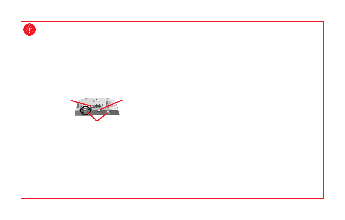
of the vehicle and road conditions while the vehicle is in motion could result in
Warnings
Failure to avoid the following potentially hazardous situations could result in
an accident or collision resulting in death or serious injury.
The BMW Motorrad Navigator III must only be secured to BMW motorcycles
with holders approved by BMW Motorrad.
For use in or on other vehicles, it is the sole responsibility of the owner/operator
of the BMW Motorrad Navigator III to place and secure the unit so that it does
not interfere with vehicle operating controls or obstruct the driver’s view of the
road (see diagram). The mounting hardware provided by BMW Motorrad is not
warranted against collision damage or the consequences thereof.
Do not mount where
driver’s eld of vision
is blocked.
Do not mount in front of an airbag eld of deployment.
Tighten the security screw on the top of the motorcycle mount before driving
with the BMW Motorcycle Navigator III. Failure to tighten the screw could result
in the unit falling out of the mount that could cause bodily injury or property
damage in addition to damage to the unit.
It is the sole responsibility of the driver of the vehicle to operate the vehicle in a
safe manner, maintain full surveillance of all driving conditions at all times, and
not become distracted by the BMW Motorrad Navigator III to the exclusion of
safe driving practices. It is unsafe to operate the controls of the BMW Motorrad
Navigator III while you are riding or driving. Failure by the driver of a vehicle
equipped with a BMW Motorrad Navigator III to pay full attention to operation
Do not place
unsecured on the
vehicle dashboard.
an accident with property damage and personal injury.
Using the BMW Motorrad Navigator III in no way relieves the driver of
responsibility. The currently valid trafc regulations must always be observed. Be
aware of the current trafc situation at all times. It is more important to observe
the road trafc than look at the display. If the current trafc situation and the
information of the BMW Motorrad Navigator III are conicting, the currently
valid trafc regulations and the current trafc situation always have priority over
the information given by the BMW Motorrad Navigator III.
For road safety reasons, enter details in the Navigator III before starting the
journey or with the motorcycle stationary. Only look at the display if the trafc
situation allows it; it is more important to observe the trafc and keep your hands
on the handlebars. Otherwise, stop at a suitable location and look at the display
with the motorcycle stationary.
Use the BMW Motorrad Navigator III at your own risk. To reduce the risk of
unsafe operation, carefully review and understand all aspects of this reference
guide and thoroughly practice safe operation using the simulator mode prior
to actual use. When in actual use, carefully compare indications from the
BMW Motorrad Navigator III to all available navigation sources, including the
information from other NAVAIDs, visual sightings, charts, etc. For safety, resolve
any discrepancies before continuing navigation.
Your BMW Motorrad Navigator III is equipped with a “Safe Mode” feature to
improve driver safety. This feature is enabled by default. When your vehicle is
moving, Safe Mode disables certain functions of the BMW Motorrad Navigator
III that require signicant operator attention and may become a distraction to use
while driving.

Contact Information
If you encounter any difculty while using
your BMW Motorrad Navigator III, or if you
have any questions, in the USA contact Garmin
Product Support by phone at 913/397.8200 or
800/800.1020, Monday–Friday, 8 AM–5 PM
Central Time. You can also e-mail product
support at BMWNavigatorUSA@garmin.com.
In Europe, contact Garmin (Europe) Ltd. at +44
(0) 870.8501241 (outside the UK) and 0808
2380000 (within the UK).
Serial Number
Record the serial number (8-digit number
located on the back of the unit) in case your
Navigator III needs service or you would like to
buy additional maps.
__ __ __ __ __ __ __ __
myGarmin
Go to http://my.garmin.com to access the latest
services for your Garmin products.
From the myGarmin Web site, you can:
• Register your Garmin unit.
• Subscribe to online services for safety
• Unlock optional maps.
Return to myGarmin often for new Garmin
product services.
About Google Earth
Go to http://earth.google.com to download
the Google Earth application. With Google
Earth installed on your computer, you can
view waypoints, tracks, and routes saved in
MapSource®. From the View menu, select View
in Google Earth.
Preface
™
camera information (see page 26).
™
Preface
Table of Contents
Preface .................................................1
Find It and Go .......................................3
Where To ..............................................5
My Locations ........................................7
Using the Map ....................................10
Creating and Editing Routes ..............12
Using The Track Logs ........................14
Using Bluetooth® Wireless Technology
Features ........................................15
Trafc Information ...............................18
Customizing the Navigator III .............19
Appendix ............................................25
Navigator III Troubleshooting .............30
Navigator III Owner’s Manual
Preface
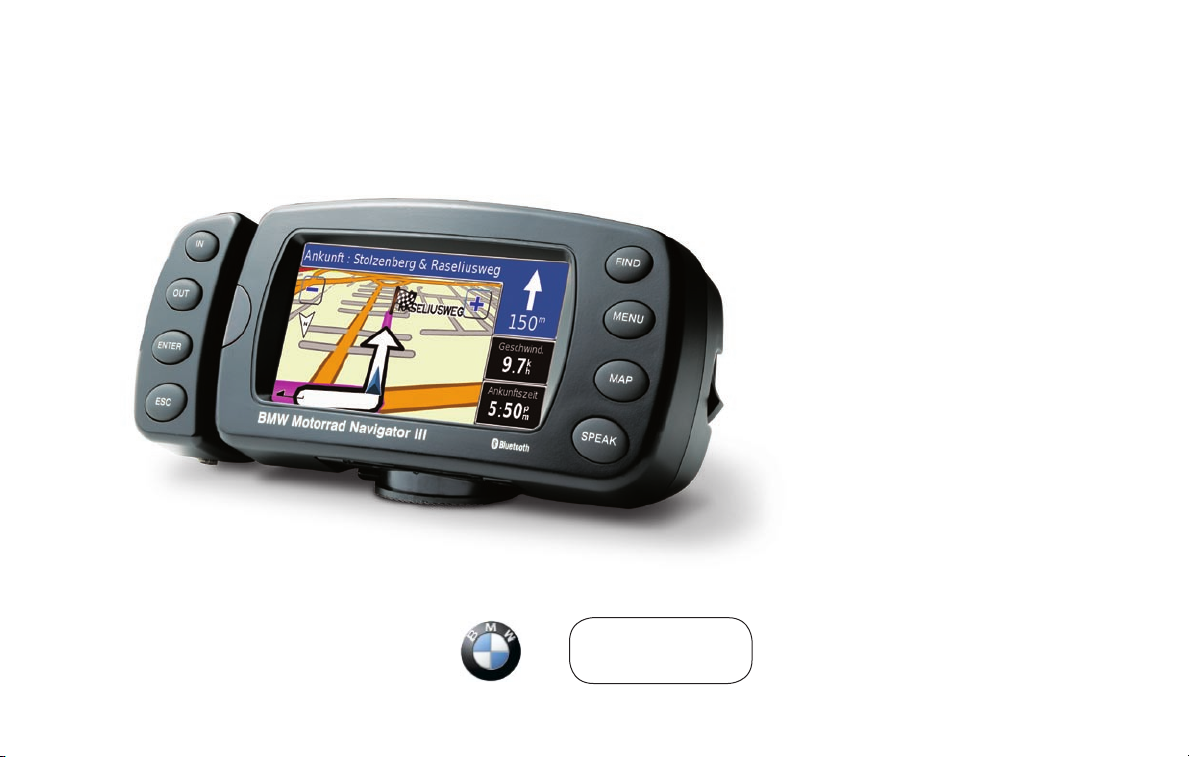
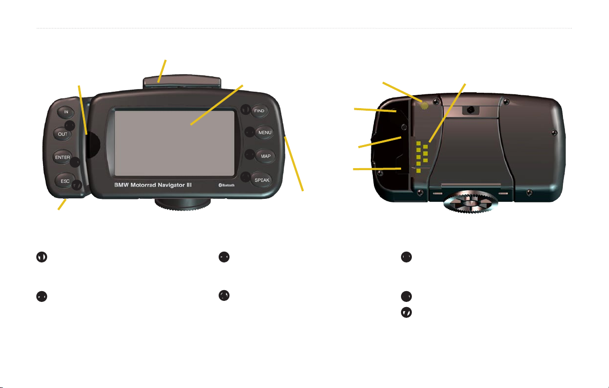
Looking at the Navigator III
IR window
(aim the optional
remote here)
Cradle lock (push down and then tighten the
security screw before driving)
Touch screen
Light sensor
Power cable connector
➊
➎
➏
➐
Audio jack
FIND opens the Find menu. Press twice to
➊
go home. Press and hold to open the Recent
Finds list.
MENU opens the Main menu. Press
➋
repeatedly to scroll through the Main,
Tools, and Settings menus. Press and hold
to open the Routes menu.
Navigator III Owner’s Manual
Front of Navigator III (in Mount) Back of Navigator III (out of Mount)
➋
➌
➍
MAP opens the map. Press repeatedly to
➌
scroll through the map, Trip Computer, and
Compass page.
➍
SPEAK announces voice directions. Press
and hold to adjust the volume.
MCX connector
(for optional
remote antenna)
Weather cap
Mini-USB
connector
Power switch
IN/OUT zooms in and out of the map,
➎
selects buttons and options. Press and hold
to scroll through multi-page lists.
ENTER conrms a highlighted selection.
➏
ESC exits a menu or window.
➐
find it and Go
find it and Go
As soon as you turn on the Navigator III, it begins acquiring GPS satellite signals. The rst time you acquire satellites, it may take a few minutes. Stop
your vehicle and position the Navigator III where it has a clear view of the sky. The bars in the upper-left corner indicate satellite strength. Touch
the bars to view more information about the GPS signals.
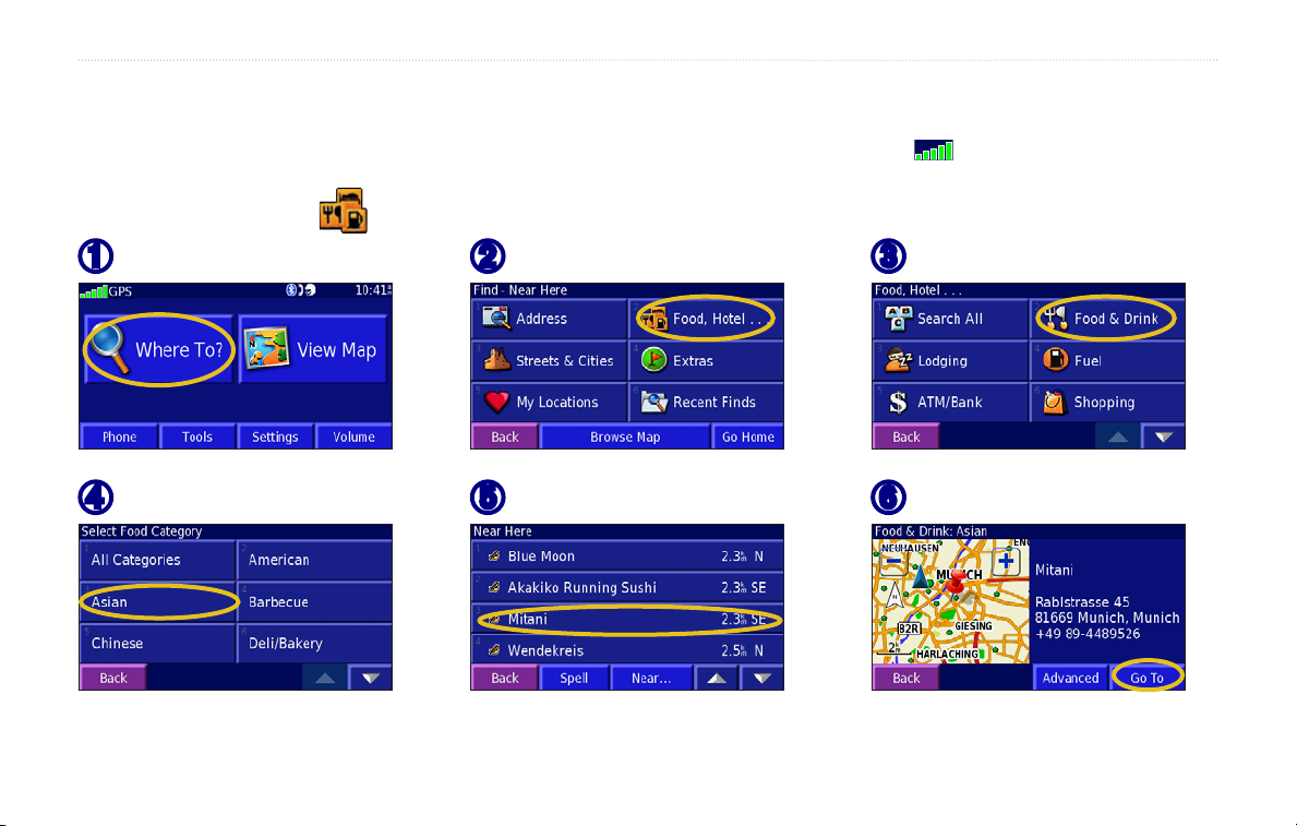
Finding a Restaurant
Touch Where To.
➊
Touch a food category.
➍
Navigator III Owner’s Manual
Touch Food, Hotel.
➋
Touch a location.
➎
Touch Food & Drink.
➌
Touch Go To.
➏
find it and Go
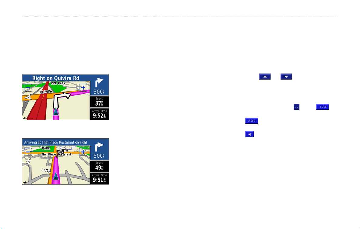
Following Your Route
As you travel to your destination, your
Navigator III guides you to your destination
with voice prompts, arrows, and directions
along the top of the map. If you depart from the
original route, your Navigator III recalculates
the route and provides new route instructions.
Follow the arrows. Your route is
marked with a magenta line.
A checkered ag marks your
destination.
Stopping Your Route
Press the MENU key, and touch Stop > Yes.
Adding a Detour to a Route
Press the MENU key, and touch Detour.
1 kilometer, 5 kilometers, or 10 kilometers—
select the distance of the detour. For example if
a road sign indicates that the street is closed for
the next three kilometers, touch 5 kilometers.
Your Navigator III recalculates your route for
the next ve kilometers.
Detour by Road(s) In Route—select roads in
your route to avoid. For example, if the ramp is
closed, select the ramp in the list of roads. Your
Navigator III recalculates your route to avoid
that ramp.
Detour by Trafc Event on Route—if you
are using an FM trafc receiver, you can detour
around trafc events.
Remove All Detours—touch to remove detours
you have entered for the route.
Navigator III Tips
• Use your nger to touch the screen and
select objects. You can also press the keys
on the front of the unit or on the optional
remote control to operate your Navigator III.
• Touch the Back button to return to the
previous screen.
• Touch and to view all of the
items in a list.
• When a keyboard appears on the screen,
type the name or numbers using your nger.
To enter a space, touch . Touch to
enter numbers or special characters. Touch
to use the diacritical keyboard. To
delete the last character you entered, touch
.
• You can look at other areas of the map by
touching the map and pulling your nger
across the screen. See page 10.
• To adjust the volume, touch
Main menu.
Volume on the
Navigator III Owner’s Manual

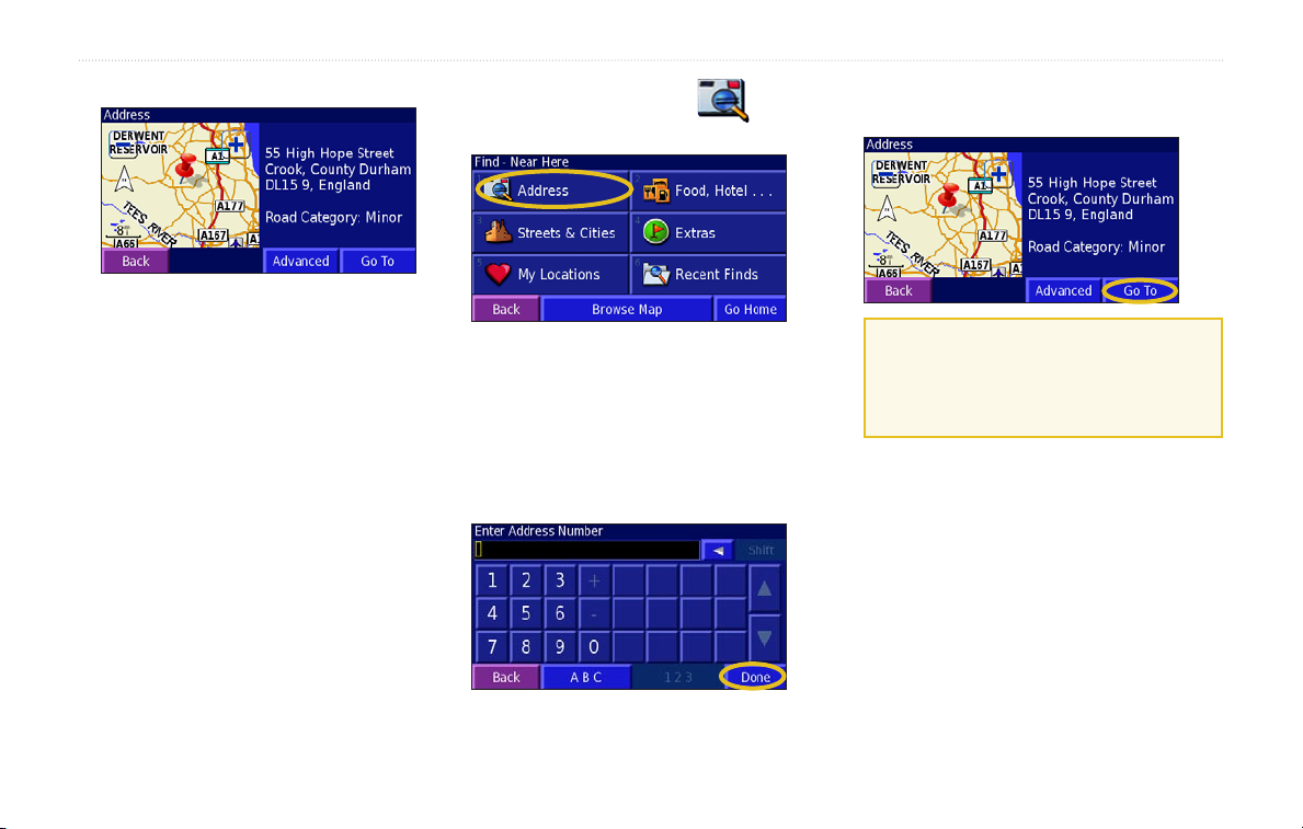
Where to
Where to
Find Menu
Press the FIND key, or touch Where To on the
Main menu.
Recent Finds—nd locations you have
recently selected from the search result list.
Browse Map—use the map to nd the location
you are looking for, which can be helpful when
you know where the location is, but do not
know the name.
Go Home—creates a route to your home
location. To set your home location, see page 7.
Search Results
Your Navigator III sorts the search results list
by distance from your current location; the
closest locations are listed rst.
Address—enter the house number and street
name to nd a specic address.
Food, Hotel—search for locations, such as
restaurants, schools, and hospitals.
Streets & Cities—nd a city (city centre),
street, intersection, or exit.
Extras—nd custom POIs or Garmin
TourGuide™ POIs loaded on your Navigator III.
For more information, see page 26.
My Locations—save your favorite locations.
For example, you can save the hotel where you
will be staying while on vacation.
Navigator III Owner’s Manual
Finding Locations in a Different
Area
1. From the search results list, touch Near.
2. Select one of the search options. The
locations near the option you selected
appear.
Narrowing Your Search
1. From the search results list, touch Spell.
2. Enter part of the name, and touch
Done.
Recently Found Locations
Your Navigator III stores the last 50 locations
you have found in Recent Finds.
1. Touch Where To > Recent Finds.
2. Select a location from the list.
Touch Category to sort by a specic category,
such as Food, Hotel.
Where to
Information Page
Touch Go To to create a route to this location.
Touch Advanced to view other options for this
location:
• Insert in Current Route—add this location
as the next stop (point) in your route.
• Dial Phone Number—place a call to this
location, if your phone with Bluetooth®
technology is connected. See pages 15–17.
• Add As Favorite—add this location to your
Favorites. For more information, see page 7.
• Find Near Point—nd a location near this
location.
• Browse Map—view this location on the
map.
Finding an Address
1 Touch Where To > Address.
2. Touch a country or state. Touch Search
All Cities or Select City/Postal Code.
3. Enter the city or postal code, and touch
Done.
4. Select the city/postal code.
5. If necessary, enter the rest of the address,
and touch
Done.
6. Select the address, if necessary.
7. Touch
Go To.
TIP: Searching for a city, street,
intersection, or exit is very similar to
searching for an address. Touch Where To
> Streets & Cities.
Navigator III Owner’s Manual
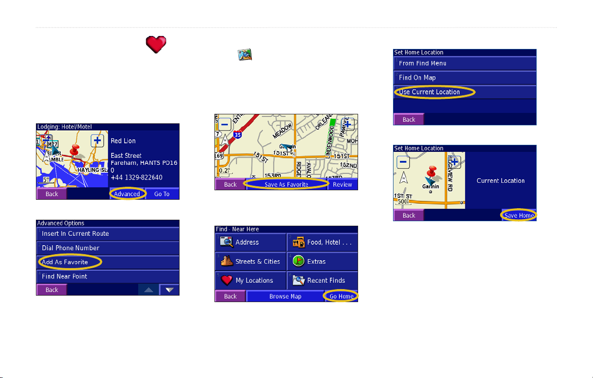
My Locations
My Locations
Saving Locations
Any time you are viewing a location’s
information page, you can save that location as
a Favorite.
1. Touch Advanced.
2. Touch Add As Favorite.
Saving Your Current Location
Touch View Map. You can also press the
MAP key on the front of the Navigator III.
1. Touch anywhere on the map.
2. Touch
Setting a Home Location
1. Touch Where To > Go Home.
2. Select an option.
Save As Favorite to save your
current location.
3. Touch Save Home.
Press the FIND key twice to create a route
to your home location. To change your home
location, rst delete it from your Favorites (see
page 8 for more information). Then set it again
using the instructions above.
Navigator III Owner’s Manual

My Locations
Finding Saved Locations
From the Main menu, touch Where To > My
Locations > Favorites.
Editing Saved Locations
1. Touch Tools > My Data > Favorites.
2. Touch
3. Touch a location to edit.
Edit/Review Favorites.
4. Touch Edit.
5. Select an option to edit.
Name—enter a new name for the location
using the on-screen keyboard.
Location—edit the physical location of the
saved location; you can use the map or enter
new coordinates using the keyboard.
Elevation—enter the elevation of the saved
location.
Category—assign this location to a
category; touch to view the
categories.
Symbol—select a symbol to appear on the
map for this location.
Deleting a Saved Location
1. Touch Tools > My Data > Favorites >
Delete Favorites.
2. Select an option:
By Selection—touch each location and
delete it individually.
By Category—select one category to delete
all of the locations assigned to that category.
Delete All—removes all saved locations
from your Favorites.
3. Touch a saved location.
4. Touch
Delete.
Sharing Favorites
You can share Favorites, routes, and tracks with
other Navigator III owners using Bluetooth
technology. First, give the Navigator IIIs unique
friendly names. Touch Settings > Bluetooth >
Friendly Name.
1. Touch Tools > My Data > Favorites>
Transfer Favorites using Bluetooth.
Your Navigator III will look for other
Bluetooth devices.
Navigator III Owner’s Manual
 Loading...