

Garmin GPSMAP 696, GPSMAP 695 Quick Reference

GPSMAP® 695/696
Portable Aviation Receiver
Quick Reference Guide


Copyright © 2009, 2012 Garmin Ltd. or its subsidiaries. All rights reserved.
This manual reflects the operation of System Software version 6.00 or later. Some differences
in operation may be observed when comparing the information in this manual to earlier or later
software versions.
Garmin International, Inc., 1200 East 151st Street, Olathe, Kansas 66062, U.S.A.
Tel: 913/397.8200 Fax: 913/397.8282
Garmin AT, Inc., 2345 Turner Road SE, Salem, OR 97302, U.S.A.
Tel: 503/391.3411 Fax 503/364.2138
Garmin (Europe) Ltd, Liberty House, Bulls Copse Road, Hounsdown Business Park,
Southampton, SO40 9RB, U.K.
Tel: 44/0870.8501241 Fax: 44/0870.8501251
Garmin Corporation, No. 68, Jangshu 2nd Road, Shijr, Taipei County, Taiwan
Tel: 886/02.2642.9199 Fax: 886/02.2642.9099
Web Site Address: www.garmin.com
Except as expressly provided herein, no part of this manual may be reproduced, copied, transmitted,
disseminated, downloaded or stored in any storage medium, for any purpose without the express
written permission of Garmin. Garmin hereby grants permission to download a single copy of this
manual and of any revision to this manual onto a hard drive or other electronic storage medium to
be viewed for personal use, provided that such electronic or printed copy of this manual or revision
must contain the complete text of this copyright notice and provided further that any unauthorized
commercial distribution of this manual or any revision hereto is strictly prohibited.
Garmin®,GPSMAP®, FliteCharts® and SafeTaxi® are registered trademarks of Garmin Ltd. or its
subsidiaries. These trademarks may not be used without the express permission of Garmin.
Jeppesen® is a registered trademark of Jeppesen, Inc.
NavData® is a trademark of Jeppesen, Inc.
AC-U-KWIK
SiriusXM Satellite Radio is provided by of SiriusXM Satellite Radio, Inc.
SiriusXM Weather is provided by of SiriusXM Satellite Radio, Inc
®
is a registered trademark of Penton Business Media, Inc.
August, 2012 190-00959-00 Rev. E Printed in Taiwan.

Part Number Change Summary
190-00959-00 Initial release
Rev Date Description
C November,
Production Release
2008
D February,
2012
System Software Version 2.00 - 2.20 changes:
• Added separate leg and cumulative distance, ETE, and fuel fields to the
flight plan pages.
System Software Version 2.20-2.30 changes:
• Added indication of airport CTAF frequencies to WPT page.
System Software Version 2.70-2.80 changes:
• Added display of plain-language PIREP text.
• Added display of VOR radials when airway is highlighted.
• Added display of country when reviewing a user waypoint.
• Added sea surface temperature data.
• Added display of parachute jumping area.
System Software Version 2.90-3.00:
• Added daylight savings time information display on Airport Waypoint
page.
System Software Version 3.10-3.20 changes:
• FlightCharts are no longer disabled after fade date.
• Added ability to import/export flight data via datacard.
• Added ablility to highlight multiple weather objects using map cursor.
• Added XM page menu option for selecting a specific channel number.
• Added nearest airport page softkeys for toggling on/off private airports
and heliports.
• Added TIS traffic data status indicator to the Map Page.
System Software Version 3.30-4.00 changes:
• Added user-created checklists.
• Added support to export user waypoints and track logs to SD card.
• Added support for ChartView and geo-referenced FlightCharts.
System Software Version 4.20-4.30 changes:
• Added SiriusXM warning text.
• Added menu options to WPT page for viewing departure and destina-
tion airports.
• Added displaced runway threshold distance on airport review page.
• Added suggested indicated altitude on E6B page.
RR-4
Garmin GPSMAP 695/696 Quick Reference Guide
190-00959-00 Rev. E

E August,
2012
System Software Version 4.40-4.50 changes:
• Added AC-U-KWIK airport data support.
System Software Version 4.70-4.80 changes:
• Added display setup option to show/hide aircraft position on maps and
charts
System Software Version 4.80-4.90 changes:
• Added configurable data fields to display current climb gradient in
percent or altitude gain per nautical mile.
• Added runway number labels to runway extension lines on map.
• Added Map Setup page items for adjusting visibility of water labels,
park and land cover areas, runway numbers, and runway extension
lines.
• Added separate control for speed and distance units.
• Added custom waypoint symbols support.
• Changed screenshot utility to be activated when Menu key is pressed
and held.
• Changed XTK data fields display to more closely resemble G3X
presentation.
Other changes:
• Changed XM to SiriusXM throughout.
• Added TRAFFIC Softkey to Map Page Softkeys.
• Added AOPA/DIRECTORY Softkey update info.
• Added Terrain Page Softkeys.
• Added Info Page Softkey.
• Added Active Flight Plan Page Softkeys.
• Added Flight Plan List Page Softkeys.
• Added VNAV Page Softkeys.
• Added Nearest Page Softkeys.
• Updated AIRMETS and SIGMETS
• Added PIREP info.
• Added Turbulence Forecast info.
• Added Icing Forecast info.
• Updated Chartview and FliteChart info.
• Updated AOPA Airport Directory to just Airport Directory where ap-
plicable.
• Updated System Messages.
• Updated Data Field Options.
• Updated database information.
System Software Version 4.90-6.00 changes:
• Added GDL 39 support
190-00959-00 Rev. E
Garmin GPSMAP 695/696 Quick Reference Guide
RR-5

Blank Page
RR-6
Garmin GPSMAP 695/696 Quick Reference Guide
190-00959-00 Rev. E

Table of Contents
Overview .......................................................................................................... 1
Softkeys ............................................................................................................................3
MAP Page Softkeys .............................................................................................................. 3
Waypoint Page Softkeys........................................................................................................ 4
Weather Page Softkeys (XM 696 only, GDL 695/696) ............................................................ 4
Traffic Page Softkeys (Optional GDL 39) ................................................................................5
SiriusXM Audio Page Softkeys (GPSMAP 696 ONLY) .............................................................. 6
Data Entry .........................................................................................................................7
Menus ................................................................................................................................7
Pages .................................................................................................................................8
GPS Navigation................................................................................................ 9
Panel ..................................................................................................................................9
Waypoint Page ...............................................................................................................10
Nearest Pages .................................................................................................................10
User Waypoints ...............................................................................................................11
Direct-to ..........................................................................................................................12
Flight Planning .............................................................................................. 13
Flight Plan Creation .......................................................................................................13
Flight Plan Storage ........................................................................................................13
Flight Plan Activation ....................................................................................................14
Adjusting Fuel Flow .......................................................................................................15
Inverting a Flight Plan ...................................................................................................15
Selecting an approach ...................................................................................................15
Activating Vectors-to-final ............................................................................................16
Hazard Avoidance .......................................................................................... 17
Weather Source (GPSMAP 696 ONLY) ...........................................................................17
SiriusXM Weather (GPSMAP 696 ONLY) .......................................................................17
Data Link Weather (FIS-B) (695 and 696) ......................................................................18
Terrain .............................................................................................................................19
Traffic Source ..................................................................................................................20
Traffic Information Service (TIS-A) ...............................................................................21
Data Link Traffic (GDL 39) ..............................................................................................21
Additional Features ...................................................................................... 23
SafeTaxi ...........................................................................................................................23
ChartView (Optional) .....................................................................................................23
FliteCharts.......................................................................................................................24
Airport Directory Data ..................................................................................................25
190-00959-00 Rev. E
Garmin GPSMAP 695/696 Quick Reference Guide
RR-7

Table of Contents
Messages & Alerts ......................................................................................... 27
System messages ...........................................................................................................27
Airspace Messages ............................................................................................................. 29
Aural Alerts ........................................................................................................................ 29
Utilities ........................................................................................................... 31
Flight Log ........................................................................................................................31
Track Log .........................................................................................................................31
E6B Calculator ................................................................................................................32
Aircraft Profile ................................................................................................................32
Weight & Balance ...........................................................................................................33
Proximity Waypoints ......................................................................................................33
RR-8
Garmin GPSMAP 695/696 Quick Reference Guide
190-00959-00 Rev. E
Overview
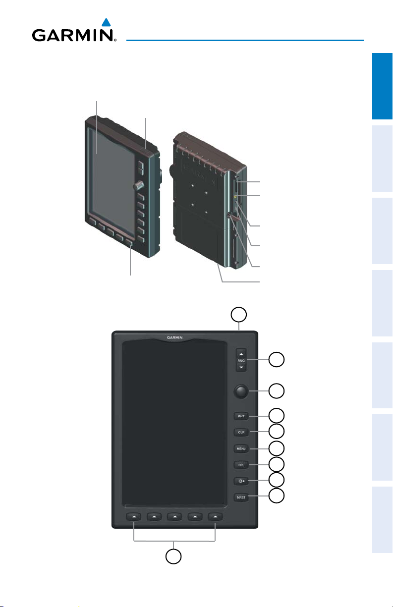
OVERVIEW
7” WVGA (800x480)
Color Display
Backlit Keypad
Overview GPS Navigation Flight Planning Hazard Avoidance Additional Features Messages & Alerts Utilities
Power Button
SD Card Slot
External GPS Antenna
Connector
Audio (Headphones/Line Out)
USB Connector
External Power/Serial Port
Connector
Battery Pack
Unit Overview
1
190-00959-00 Rev. E
2
3
4
5
6
7
8
9
10
Garmin GPSMAP 695/696 Quick Reference Guide
1

Overview
1
2
OverviewGPS NavigationFlight PlanningHazard AvoidanceAdditional FeaturesMessages & AlertsUtilities
3
4
5
6
7
8
9
10
Power
Button
Press and hold to turn the unit on or off
With the unit on, press to adjust the backlight and volume
RNG Key Press to increase or decrease the viewing range of the map
FMS
Joystick
Press the FMS Joystick to toggle input focus between user
interaction with the current page and the page navigation bar
Turn the FMS Joystick clockwise to access a dropdown menu
Turn the FMS Joystick to change the selected value within the
highlighted field
Move the FMS Joystick to highlight fields or move the map pointer
when interacting with the page
ENT Key Press to confirm menu selection or data entry
Press to acknowledge messages
Press and hold to mark a waypoint
CLR Key Press to cancel an entry, revert to the previous value in a data entry
field, or remove menus
Press and hold to return to the default page
MENU Key Press once to view the Page Menu
Press twice to view the Main Menu
Press a third time to clear the Main Menu
FPL Key Press to display the Flight Plan Page
Press a second time to remove the Flight Plan Page
Direct-To
Key
Press to activate the Direct-To function, enter a destination
waypoint, and establish a direct course to the selected destination
NRST Key Press to display the Nearest Page for viewing the nearest airports,
weather (696 ONLY), Cities, intersections, NDBs, VORs, waypoints,
frequencies, and airspaces
Softkey
Press to select the softkey shown above the bezel key on the unit
Selection
Keys
2
Garmin GPSMAP 695/696 Quick Reference Guide
190-00959-00 Rev. E
Overview
MAP
VFR MAP
BACK
IFR MAP TOPO
BACK
Press the BACK Softkey to
return to the top-level softkeys.
SAT VIEW
HIGH AWYLOW AWYIFR MAPVFR MAP
SOFTKEYS
Softkey
On
Bezel Mounted
Softkeys (Press)
Softkeys (WPT Page)
MAP PAGE SOFTKEYS
MAP
MAP Enables second-level Map Page softkeys
TERRAIN Displays/removes terrain awareness information
WEATHER Displays/removes weather information
TRAFFIC Displays/removes traffic information
PANEL Displays/removes the Panel
TERRAIN WEATHER PANELTRAFFIC
Overview GPS Navigation Flight Planning Hazard Avoidance Additional Features Messages & Alerts Utilities
Softkey Names
(Displayed)
190-00959-00 Rev. E
Garmin GPSMAP 695/696 Quick Reference Guide
3
Overview
VFR MAP Softkey selected
IFR MAP Displays IFR map information and softkeys
TOPO Displays/removes topographical terrain shading
OverviewGPS NavigationFlight PlanningHazard AvoidanceAdditional FeaturesMessages & AlertsUtilities
SAT VIEW Displays/removes satellite imagery (above 20nm scale)
BACK Returns to top-level softkeys
IFR MAP Softkey selected
VFR MAP Displays VFR map information and softkeys
LOW AWY Low Altitude (Victor) Airways displayed
HIGH AWY High Altitude Airways (Jet Routes) displayed
BACK Returns to top-level softkeys
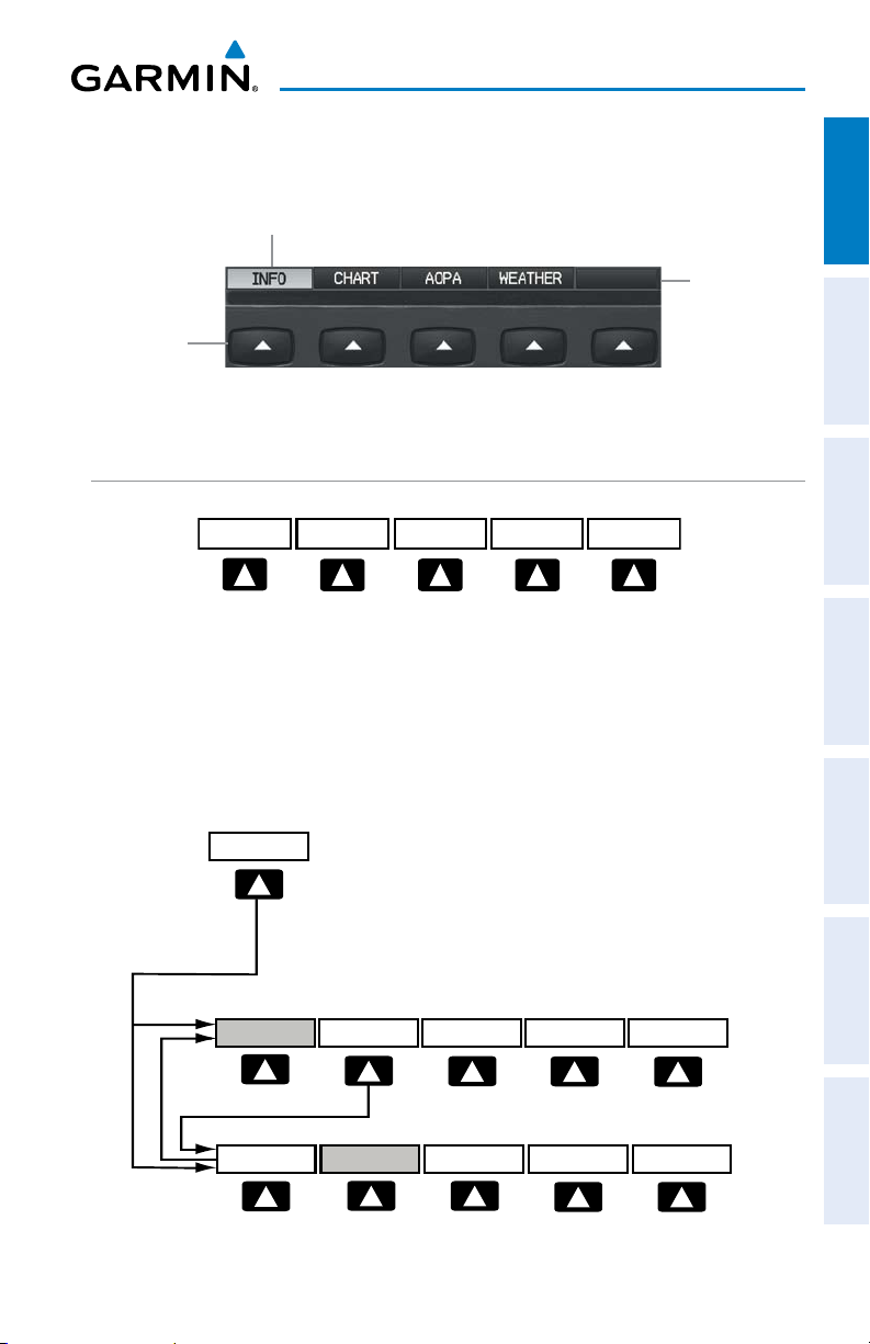
WAYPOINT PAGE SOFTKEYS
(DIRECTORY)
INFO
CHART AOPA WEATHER
Waypoint (WPT) Page Softkeys
INFO Displays waypoint information
CHART Displays chart data (i.e., FliteCharts® or ChartView)
AOPA or DIRECTORY Displays airport directory information
WEATHER Displays METAR and TAF text (optional)
WEATHER PAGE SOFTKEYS (XM 696 ONLY, GDL 695/696)
INFO
PAN MAP
ANIMATE
PAN MAP Activates the map pointer for panning the map
ANIMATE Animates NEXRAD Radar and Satellite Mosaic weather
INFO Displays weather source information
LEGEND Displays weather legends
4
Garmin GPSMAP 695/696 Quick Reference Guide
LEGEND
190-00959-00 Rev. E

VOL +
BACK VOL -
MUTE
VOLUME
Press the BACK Softkey to
return to the top-level softkeys.
INFO
CHANNEL
VOLUME CATEGORY
PRESETS
PAN MAP
ANIMATE
LEGEND
INFO
CHART
APPRCH
AOPA WEATHER
MAP
VFR MAP
BACK
IFR MAP TOPO
BACK
Press the BACK Softkey to
return to the top-level softkeys.
SAT VIEW
HIGH AWYLOW AWYIFR MAPVFR MAP
MAP
TERRAIN
WEATHER
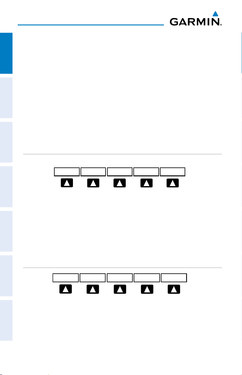
TRAFFIC PAGE SOFTKEYS (OPTIONAL GDL 39)
INFO
ALT MODE
DISABLEFLT ID
Overview
Overview GPS Navigation Flight Planning Hazard Avoidance Additional Features Messages & Alerts Utilities
INFO Select to view Data Link and Weather info
INFO
STATIONS
SETUP
BACKUNRESTABOVEBELOW NORMAL
EXIT
FLT ID Displays FLT ID information.
ALT MODE Select to set altitude mode.
DISABLE Temporally disables traffic alerts
ALT MODE Softkey selected
BELOW Displays non-threat and proximity traffic from 2700 feet
NORMAL Displays non-threat and proximity traffic from 2700 feet
ABOVE Displays non-threat and proximity traffic from 9000 feet
UNREST (Unrestricted): All traffic is displayed from 9900 feet
above the aircraft to 9000 feet below the aircraft.
Typically used during descent phase of flight.
above the aircraft to 2700 feet below the aircraft.
Typically used during enroute phase of flight.
above the aircraft to 2700 feet above the aircraft.
Typically used during enroute phase of flight.
above and 9900 feet below the aircraft.
INFO Softkey selected
Stations Displays ADS-B ground station(s) information.
SETUP Select to set pressure altitude sensor on or off in the
GDL 39.
EXIT Returns to the Traffic Page.
190-00959-00 Rev. E
Garmin GPSMAP 695/696 Quick Reference Guide
5
Overview
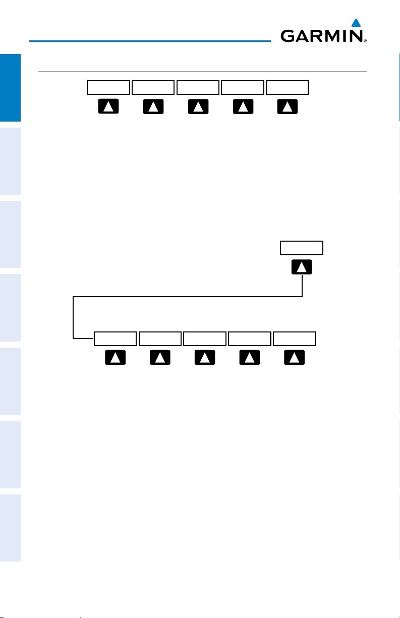
SIRIUSXM AUDIO PAGE SOFTKEYS (GPSMAP 696 ONLY)
OverviewGPS NavigationFlight PlanningHazard AvoidanceAdditional FeaturesMessages & AlertsUtilities
INFO
CATEGORYFAVORITE
CHANNEL
INFO Displays SiriusXM Information
CATEGORY Highlights the Category field
CHANNEL Highlights the Channels field
FAVORITE Displays a list of favorite channels
VOLUME Enables second-level VOLUME softkeys.
Press and hold to toggle Mute on and off.
Press the BACK Softkey to
return to the top-level softkeys.
VOL +
BACK VOL -
MUTE
VOLUME
VOLUME
VOL - Decreases SiriusXM audio volume
VOL + Increases SiriusXM audio volume
MUTE Toggles SiriusXM audio on/off
BACK Returns to top-level softkeys
6
Garmin GPSMAP 695/696 Quick Reference Guide
190-00959-00 Rev. E
 Loading...