

Page 1
Add-on for Microsoft
MadeiraMadeira
Handbuch/Manual
Page 2

Scenery Madeira
Developed by: Aerosoft GmbH
Scenery design: Peter Werlitz
Autogen Madeira: Renate Werlitz
Aerial images: Secretaria Regional Do Equipamento Social
da Madeira
Geo reference: GeoContent GmbH
AI-Traffic: Burkhard Renk
Manual: Günter Zehnel
Installation: Andreas Mügge
Many thanks to the authorities of Aeroporto da Madeira give us
permission to make photos of the airport facilities.
Many thanks to all beta testers of this scenery
Copyright: © 2008/ Aerosoft GmbH
Flughafen Paderborn/Lippstadt
D-33142 Büren, Germany
Tel: +49 (0) 29 55 / 76 03-10
Fax: +49 (0) 29 55 / 76 03-33
E-Mail: info@aerosoft.de
Internet: www.aerosoft.de
www.aerosoft.com
All trademarks and brand names are trademarks or registered of their
respective owners. All rights reserved. /
namen sind Warenzeichen oder eingetragene Warenzeichen ihrer jeweiligen
Eigentümer. Alle Urheber- und Leistungsschutzrechte vorbehalten
Aerosoft GmbH 2008
Alle Warenzeichen und Marken-
2
.
Page 3
Scenery
Madeira
Handbuch
Manual
Erweiterung zum /
Add-on for
Microsoft Flight Simulator X
3
Page 4

Scenery Madeira
Inhalt
Willkommen zuScenery Madeira ..............................6
Systemvoraussetzungen ..................................................... 7
Installation ........................................................................... 7
Deinstallation .............................................................. 8
Support ................................................................................. 9
Die Inseln Madeiras .................................................10
Die Geschichte Madeiras ................................................... 10
Die Flughäfen ...........................................................12
Madeira Airport ................................................................. 12
Technische Angaben ................................................. 13
Statistische Angaben ................................................. 13
Porto Santo Airport ........................................................... 14
Technische Angaben ................................................. 14
Statistische Angaben ................................................. 15
Anhang .....................................................................16
Häufige Fragen .................................................................. 16
Empfohlene Einstellungen ................................................ 20
Aerosoft GmbH 2008
4
Page 5
Content
Welcome to „Scenery Madeira“ .............................23
System requirements ......................................................... 24
Installation ......................................................................... 24
Removing “Scenery Madeira“ ................................... 25
Technical Support .............................................................. 25
The Madeira Islands ................................................26
Brief history of Madeira .................................................... 26
The Airports .............................................................27
Madeira airport ................................................................. 27
Technical Information ................................................ 27
Statistics .................................................................... 28
Porto Santo Airport ........................................................... 28
Technical information ................................................ 29
Statistics .................................................................... 29
Appendix ..................................................................30
FAQ ..................................................................................... 30
Recommended Settings .................................................... 33
5
Page 6

Scenery Madeira
Willkommen zu Scenery Madeira
Die portugiesische Inselgruppe Madeira liegt im Atlantischen Ozean,
etwa 700 km westlich der marokkanischen Küste. Die Inselgruppe besteht
aus der Hauptinsel Madeira, der kleineren Insel Porto Santo und zwei
unbewohnten Inselgruppen, den Ilhas Desertas und den Ilhas Selvagens.
Die Landschaft Madeiras besitzt einen ausgeprägten Mittel- bis
Hochgebirgscharakter. Die Küsten fallen steil ins Meer und gehören
mit 580 Metern zu den höchsten Steilküsten Europas. Der höchste
Gipfel ist der Pico Ruivo mit 1862 m.
Madeira ist Teil Portugals und gehört zum Gebiet der Europäischen Union.
94,5 % der Bevölkerung Madeiras gehören der römisch-katholischen
Kirche an. Madeira hat ein Fläche von 794 km². Davon entfallen 741
km² auf die Hauptinsel Madeira und 45 km² auf die kleinere Insel
Porto Santo. Die Hauptstadt der Inselgruppe ist Funchal
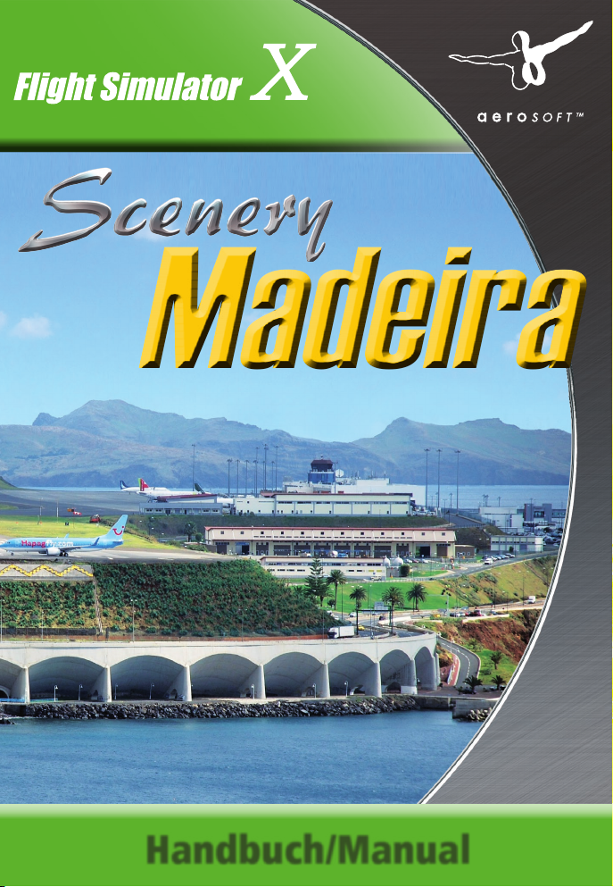
Unsere Szenerie umfasst die Hauptinsel Madeira mit dem Flughafen
Madeira sowie die Insel Porto Santo mit dem dort gelegenen Flughafen.
Beide Inseln besitzen aktuelle Luftbildern mit einer Auflösung von 0,5 m/
Px und einem hochaufgelösten Elevated Mesh Terrain welches eine
Auflösung von 9,5 m (LOD12) hat.
Der Airport Madeira (früher Funchal) gehört aufgrund seiner geografischen
Besonderheiten zu den anspruchsvollsten Flugplätzen. Der visuelle
Anflug ist eine Herausforderung für alle Piloten, die deshalb auch eine
spezielle Lizenz für Landungen auf Madeira besitzen müssen.
Nicht nur die häufig vorhandenen starken Seitenwinde, sondern auch
die, trotz Verlängerung, nur 2.481 m lange Runway erfordern vom
Piloten höchste Aufmerksamkeit und bieten kaum Reserven bei Notfällen.
Auf ca. 50 m Höhe liegt die Landebahn direkt am Meer.
Etwa 900 m der Landebahn liegen auf einer durch Säulen getragenen
Plattform.
Aerosoft GmbH 2008
6
Page 7

Systemvoraussetzungen
Um unsere „Scenery Madeira“ möglichst störungsfrei nutzen zu
können sollte Ihr PC über folgende Mindestausstattung verfügen:
Flight Simulator X mit Service Pack 2 •
DVD-ROM-Laufwerk•
Prozessor 3 GHz, empfohlen Core 2 Duo •
Grafikkarte: 256 MB (512 empfohlen) •
1 GB RAM (2 GB empfohlen)•
1,5 GB freier Festplattenspeicherplatz•
Soundkarte•
Windows XP, Windows Vista•
Installation
Sie müssen als System administrator angemeldet sein, bevor Sie mit der
Installation von „Scenery Madeira“ beginnen können. In der Regel wird
das Setupprogramm automatisch gestartet. Das Setupprogramm
installiert „Scenery Madeira“ für den Microsoft Flugsimulator X.
Sollte das Setupprogramm nach dem Einlegen der DVD-ROM nicht
automatisch gestartet werden, klicken Sie auf „START / AUSFÜHREN“
und geben Sie „D:\setup.exe“ ein (D steht hier symbolisch für den
Buchstaben Ihres DVD-Laufwerks). Bitte beachten Sie, dass Sie für die
Installation von „Scenery Madeira“ eine gültige Seriennummer benötigen.
Sie finden diese Seriennummer auf der DVD-Hülle.
Nach der Sprachauswahl werden Sie von der Installationsroutine
begrüßt und erhalten einige Informationen zu „Scenery Madeira“.
Anschließend erscheinen die Lizenzbestimmungen zur Nutzung von
„Scenery Madeira“. Sie müssen diesen Lizenzbestimmungen zustimmen,
um „Scenery Madeira“ installieren zu können. Klicken Sie anschließend
auf „Weiter“.
7
Deutsch
Page 8

Scenery Madeira
Sie werden jetzt zur Eingabe der Seriennummer aufgefordert. Sie finden
die Seriennummer auf der DVD-Hülle. Geben Sie die Seriennummer so
ein, wie sie auf dem Etikett aufgedruckt ist, beachten Sie dabei die
Groß- und Kleinschreibung. Klicken Sie anschließend auf „Weiter“.
Nun wird das Installationsverzeichnis (Verzeichnis des Microsoft
Flugsimulator) automatisch gesucht und geprüft. Sollte die Installationsroutine das Microsoft Flugsimulator Verzeichnis nicht finden oder Sie
möchten ein anderes Verzeichnis vorgeben, so können Sie dieses über
den „Durchsuchen“-Button festlegen. Klicken Sie auch hier auf „Weiter“.
Bevor nun der eigentliche Installationsvorgang beginnt, werden die
wichtigsten Daten noch einmal zusammengefasst angezeigt. Die
Installationsroutine von „Scenery Madeira“ kopiert nun im Einzelnen
die Daten in das FSX-Verzeichnis.
Die Szenerie wird automatisch in der Szeneriebibliothek angemeldet.
Zuvor werden automatisch Sicherungskopien dieser Dateien erstellt.
Deinstallation
Um „Scenery Madeira“ zu deinstallieren, klicken Sie auf den „Start“-Button
in der Taskleiste von Windows. Hier wählen Sie dann „Einstellungen“
dort „Systemsteuerung“. In der Systemsteuerung wählen Sie den
Punkt „Programme und Funktionen“ (Windows Vista) bzw. „Software“
(Windows XP).
Sie erhalten eine Liste der installierten Programme. Markieren Sie in
dieser Liste den Eintrag „aerosoft‘s -Scenery Madeira“ mit einem
Mausklick. Klicken Sie anschließend auf „Deinstallieren“ (Windows
Vista) bzw. „Entfernen“ (Windows XP). Nun meldet sich das Deinstallationsprogramm und entfernt alle Szenerie-Dateien von Ihrer Festplatte. Die
Anmeldung in der Szenerieblibliothek wird ebenfalls durch die
Deinstallationsroutine entfernt.
und
Aerosoft GmbH 2008
8
Page 9
Support
Aerosoft bietet Ihnen bei Fragen zu diesem Produkt natürlich auch
einen Support an. Am besten ist es, wenn Sie Ihre Fragen direkt im
AerosoftForum antworten wir Ihnen in der Regel am schnellsten, da die meisten
Mitarbeiter,
regelmäßig online sind. Des Weiteren helfen Ihnen eventuell schon
andere Kunden weiter, während wir noch schlafen.
Aerosoft Forum: http://forum.aerosoft.com
Updates, sofern verfügbar, finden Sie auf der Aerosoft-Webseite
(www.aerosoft.de) unter Flugsimulation -> FAQ’s / Updates
(Produktregistrierung erforderlich).
Kunden, welche dieses Produkt als Download erworben haben, finden
eventuell vorhandene Updates in Ihrem Kundenkonto.
Forum stellen. Dies aus einem ganz einfachen Grund: Im
welche an diesem Produkt mitgearbeitet haben, dort
Deutsch
9
Page 10

Scenery Madeira
Die Inseln Madeiras
Das Madeira Archipel liegt etwa 310 Meilen westlich der Afrikanischen
Küste und 620 Meilen südwestlich des Europäischen Kontinents zwischen
den Breitengraden N32°22´20“ und N33°7´50“ sowie den Längengraden W16°16´30“ und W17°16´38“. Diese Entfernung entspricht
ungefähr einer Flugdauer von 1 Std. und 30 Min. bis Lissabon. Das
Archipel umfasst die Inseln von Madeira, Porto Santo und den
unbewohnten Inseln von Selvagens und Desertas mit einer Gesamtfläche
von cirka 741 km². Es wurde 1418 von den Portugiesen entdeckt.
Die Geschichte Madeiras
Anfang des 15. Jahrhunderts versammelte Infante D. Henrique, auch
bekannt als Heinrich der Seefahrer, die besten Kartographen und
Navigatoren Portugals um sich. Das Ziel war es, die Küste West-Afrikas
zu erforschen. Mit einfachen Schiffen, Kompass, Stundenglas und
Sextant, waren die früheren Seekapitäne doch sehr eingeschränkt was
ihre Ausrüstung betraf. Dennoch schafften Sie es, wenn auch mit
einigem Glück, uns ihre wertvollen Erkenntnisse zu hinterlassen.
1419 wurden zwei sehr junge Kapitäne, Joao Goncalves Zarco und
Tristao Vaz Teixeira, beim Versuch die Afrikanische Küste zu erreichen
mit ihren Schiffen weit von ihrem Kurs, auf den Atlantik abgetrieben.
Nach vielen Tagen auf See entdeckte man schließlich Land in Form
einer Insel, die man Porto Santo nannte. Dies war eine der ersten
Entdeckungen der Navigationsschule von Henry. Nach der Rückkehr
und Meldung wurden Sie zur Insel zurückbeordert um sie zu kolonisieren.
Die Kapitäne berichteten außerdem von einer großen Wolkenmasse
am südlichen Horizont. Sie wurden beauftragt auch in dieser Richtung
nach Land zu suchen. Zu dieser Zeit war man noch der Meinung, dass
die Erde eine Scheibe sei. So gehörte eine große Portion Mut dazu
noch ein Stück weiter dem Horizont entgegen zu segeln.
Der Anblick der grossen Brecher des aufgewühlten Atlantiks und der
wilden Strömungen an der Ponta São Lourenço ließ die Bedenken der
recht abergläubischen Seefahrer sicherlich nicht geringer werden.
Aerosoft GmbH 2008
10
Page 11

Letztlich gelang es ihnen aber die Ostspitze zu umsegeln und sie
gelangten in die Bucht von Machico. Hier öffnete sich ihnen der Blick
auf eine reich bewaldete Insel, der sie den Namen Madeira (Holz) gaben.
Nach ihrer Rückkehr befahl Prinz Heinrich die sofortige Besiedlung
auch dieser Insel und so trafen die ersten Siedler, hauptsächlich aus der
Algarve, auf Madeira ein.
Heute steht im Zentrum der Hauptstadt Funchal, auf dem Platz vor der
Bank von Portugal, die Statue Zarco‘s und blickt auf die Nachfahren
der damaligen Siedler.
Deutsch
11
Page 12

Scenery Madeira
Die Flughäfen
Madeira Airport
Madeira Airport wurde am 8 Juli 1964 unter dem Namen Funchal
Airport eröffnet. Die Landebahn war nur 1600 m lang. Das erste
Flugzeug, das dort landete war eine Lockheed Super Constellation der
Airline TAP mit 80 Passagieren plus Fracht und Post an Bord. Der
Rückflug wurde mit 66 Passagieren und noch mehr Post angetreten.
Um die Sicherheit des Airports zu erhöhen, verlängerte man die
Landebahn zwischen 1982 und 1986 auf 1800 Meter.
Im Februar 1995 begann man mit den Erweiterungsarbeiten, die zu
dem heutigen Aussehen des Airports führten. Der Airport hieß von
nun an Madeira Airport. Die Landebahn bekam eine neue Ausrichtung
und wurde auf 2781 Meter verlängert. Diese Arbeiten kennzeichnen
die kompliziertesten Bauarbeiten die jemals auf der Insel ausgeführt
wurden. Die Runway wurde zum Teil auf einer Plattform über dem
Meer gebaut und steht dort auf 180 Säulen. Hinzu kam auch ein
neues Vorfeld auf dem nun 15 Flugzeuge gleichzeitig Platz haben. Im
Zuge dessen wurde dann auch ein neues Terminal und komplett neue
Zufahrtswege gebaut.
Madeira Airport hat eine in der Welt einzigartige Charakteristika. Die
geografischen und meteorologischen Eigenheiten stellen besonders
hohe Anforderungen an die Flugzeugbesatzungen. Der Wind und die
umliegenden Berge machen einen Landeanflug auch für erfahrene
Piloten zu einer Herausforderung.
Testen Sie Ihr Können indem Sie die verschiedenen Landeanflüge
einmal durchführen, wie z.B. den Nachtanflug auf Landebahn 05.
Folgen Sie den 17 Lichtern des „lead-in-ligthning“ Systems, die in
einer Kurve entlang der Küste positioniert sind, beginnend mit „Gelo“
bis hin zu „Rosario“.
Aerosoft GmbH 2008
12
Page 13

Technische Angaben
Flughafen: Madeira
ICAO-Code: LPMA
Lage: 7,1 NM ONO Funchal
Koordinaten: N32° 41,7 / W016° 46,7
Flughafenhöhe: 192‘ / 59 m
Start- und Landebahn:
RWY 05 / 23: 2.781 x 45 m, Asphalt
Navigationseinrichtungen:
VOR/DME: 112,20 FUN
NDB: 318 MAD
Funkfrequenzen:
Madeira Tower: 118,35 MHz
Madeira Approach: 119,20 MHz
Statistische Angaben
Jahr 2007 2006
Flugbewegungen 25.616 25.828
Passagiere 2.419.679 2.362.398
Fracht (in t) 6.796 7.210
Post (in t) 2.214 2.157
Deutsch
13
Page 14

Scenery Madeira
Porto Santo Airport
Porto Santo bekam schon vor Madeira einen eigenen Airport. Man
begann bereits 1959 mit den ersten Bauarbeiten. Die damalige
Landebahn hatte eine grobe Nord/Süd Ausrichtung und eine Länge
von 2000 Metern. Zu dieser Zeit wurde auch ein kleines Vorfeld und
ein kleines provisorisches Terminal gebaut. Das erste Flugzeug hier war
eine DC-4 von TAP am 20. Juli 1960.
Seit seiner Erbauung gab es mehrere Phasen der Modernisierung.
Zuerst wurde die Landebahn auf 2440 Meter verlängert und das
Vorfeld vergrößert.
Anfang der 80er begann man abermals mit der Modernisierung, die
schließlich im August 1995 beendet wurde. Es enstand ein neues
Passagier Terminal, ein neues Vorfeld und die Landebahn wurde auf
3000 Meter verlängert, so dass nun die meisten Flugzeugtypen, groß
oder klein, hier starten und landen können.
Versäumen Sie also nicht dieser wunderschönen atlantischen Insel
einen Besuch abzustatten. Der Sandstrand ist nur 1 km vom Flughafen
entfernt und das ruhige Küstengewässer ist wirklich ideal zum
Schwimmen.
Technische Angaben
Flughafen: Porto Santo
ICAO-Code: LPPS
Lage: 1 NM NNW Porto Santo
Koordinaten: N3° 04,3 / W016° 21,0
Flughafenhöhe: 341‘ / 104 m
Start- und Landebahn:
RWY 18 / 36: 3.000 x 45 m, Asphalt
Navigationseinrichtungen:
DVOR/DME: 114,90 SNT
NDB: 338 PST
Aerosoft GmbH 2008
14
Page 15

Funkfrequenzen:
Porto Santo Tower: 118,40 MHz
Madeira Approach: 119,20 MHz
Statistische Angaben
Jahr 2007 2006
Flugbewegungen 4.534 6.300
Passagiere 146.652 154.200
Fracht (in t) 242 232
Post (in t) 114 110
Deutsch
15
Page 16

Scenery Madeira
Anhang
Häufige Fragen
Frage: Warum sind die Wände der Gebäude um die Mittagszeit so
dunkel?
Antwort: Um die Mittagszeit steht die Sonne im Sommer auf
Madeira sehr hoch. Da der Simulator die Schattierung der
Gebäude und Objekte selbst regelt, sind dann selbst
schneeweiße Wände leider nur grau. Vor- und nachmittags
sind die Wände heller.
Frage: Im Versetzenmodus gelange ich unter die Szenerieoberfläche.
Antwort: Leider war es nicht möglich, ein feines festes Meshterrain
im Flugplatzbereich Madeira herzustellen. Daher wurde das
Terrain als 3D-Modell erstellt - mit dem Vorteil, dass man
eine sehr passgenaue Landschaftsmodellierung vornehmen
kann. Das Flugfeld besitzt eine landbare Oberfläche durch
die man im Versetzenmodus leider hindurch fällt. Dies ist
leider nicht anders lösbar.
Frage: Warum verschwinden oder erscheinen plötzlich Fahrzeuge
auf der Autobahn? Und warum sehen manche Fahrzeuge
so einfach aus?
Antwort: Der Flugsimulator bestimmt selbstständig, wie die Fahrzeuge
auf der Autobahn fahren. Wir können nur den Weg
vorgeben. Auch die Abstufung der Detailtiefe der Fahrzeuge
(LOD) wird vom Simulator selbst vorgenommen.
Frage: Die Framerate ist auf meinem Rechner sehr gering.
Antwort: Die Szenerie Madeira ist sehr hochauflösend. Das schafft
nicht jeder Rechner gleich gut. CPU, Grafikkarte und
Speicher beeinflussen die Rechnerleistung sehr. Besonders
die Darstellung von spiegelndem Wasser, von 3D-Wolken
und von vielen Autogen-Objekten ist sehr rechnerintensiv.
Aerosoft GmbH 2008
16
Page 17

Stellen Sie die genannten Effekte niedriger ein bis Sie
wenigstens eine Framerate von durchschnittlich 20 F/s
erreichen. Auch der Flughafen-, Schiffs- und Straßenverkehr
sollte wenigestens auf nur 40 - 50% eingestellt werden, da
auch dieser viele Ressourcen schluckt.
Frage: Die Windsäcke drehen sich nicht in den Wind und bewegen
sich nicht.
Antwort: Die Standard-Windsäcke sind äußerst hässlich. Wir haben
uns zu einer besseren Darstellung entschieden. Aber leider
ist eine Drehung in Windrichtung mit FSX-Mitteln leider
nicht möglich. Wir haben hier auf eine alte Technik bewusst
verzichtet, da sie im FSX nicht richtig funktioniert. Ebenfalls
haben wir auf eine Animation verzichtet um die Ressourcen
zu schonen, was sich positiv auf die Framerate auswirkt. Da
der Wind meistens aus nördlicher Richtung bläst, haben wir
die Windsäcke entsprechend ausgerichtet.
Frage: Die Fahrzeuge auf dem Flugfeld fahren einfach auf dem
Taxiway, obwohl das in der Realität nicht erlaubt ist.
Antwort: Die Animation der Fahrzeuge können wir leider nicht
beeinflussen. Der Simulator bestimmt selber, wo die
Servicefahrzeuge entlang fahren. Sobald das AES für den
FSX verfügbar ist, können wir das ändern.
Frage: Fluggasttreppen und Busse fahren nicht zu den Flugzeugen.
Außerdem steht das Follow-Me Fahrzeug und holt mich
nicht ab.
Antwort: Leider ist im FSX eine genau geplante Bewegung der
Servicefahrzeuge „noch“ nicht möglich. Sobald es AES für
den FSX gibt, können wir auch das ändern.
Deutsch
17
Page 18

Scenery Madeira
Frage: Warum kann ich unter der Runwaybrücke bei LPMA
- Madeira nicht hindurchsehen?
Antwort: Ursprünglich hatten wir eine Durchsicht möglich gemacht.
Dies führte allerdings dazu, dass eine Landebahnbefeuerung
nicht möglich war. Madeira ist auch in diesem Punkt etwas
besonderes und erforderte besondere Maßnahmen, damit
die Runwaybefeuerung realistisch darstellbar wurde. Wir
haben hier das Augenmerk auf eine realistische Befeuerung
gelegt und mussten dafür in Kauf nehmen, dass man nicht
mehr unter der Runwaybrücke hindurch sehen kann.
Frage: Einige Autogen-Objekte (z.B. Gebäude) hängen in der Luft!
Antwort: Durch das hochaufgelöste Elevated Mesh Terrain kann dies
passieren, wenn man sich schnell (z.B. mit dem VersetzenModus) von einem Ort zum anderen bewegt. Wenn man
sich mit dem Flugzeug mit realer Geschwindigkeit bewegt,
tritt das Problem normalerweise nicht auf.
Frage: Die Airports LPMA und LPPS liegen auf ca. 180 m = 590 ft
Höhe und das sieht ganz merkwürdig aus!
Antwort: Bei korrekt ablaufender Installation wird dies nicht geschehen.
Der Installer konnte wohl bestimmte Dateien nicht umbenennen. Bitte melden Sie dies unserem Support!
Abhilfe: Sie können dieses Problem schnell selbst lösen: Beenden Sie
den Simulator und benennen im FSX-Ordner „\Scenery\ 0502\
scenery“ die folgenden Dateien um:
APX43200.bgl in APX43200.madeira
und
cvx4320.bgl in cvx4320.madeira
Außerdem sind bei vorhandenem „MyTraffic X“ die
folgenden Dateien im MyTraffic-Ordner „Scenery“
umzubenennen:
BR2_LPMA.bgl in BR2_LPMA.madeira
und
BR2_LPPS.bgl in BR2_LPPS.madeira
Aerosoft GmbH 2008
18
Page 19

Frage: Das Elevated-Mesh-Terrain baut sich bei mir anscheinend
nicht voll auf.
Antwort: Das Mesh-Terrain hat eine Auflösung von LOD12 = 9,5 m
und damit das auch dargestellt wird, sind die Einstellungen,
wie im Handbuch aufgezeigt vorzunehmen (siehe auch
unten „Abhilfe“). Außerdem wird das Meshterrain
langsamer aufgebaut, wenn man im „Versetzenmodus“ die
Position schnell wechselt.
Abhilfe: Bitte befolgen Sie die Einstellungen im Handbuch: Anhang
- Empfohlene Einstellungen.
Auf etwas schwächeren Systemen kann es erforderlich sein,
die Wassereffekte zu vermindern, Bodenszenerieschatten
auszustellen und auf 3D-Wolken zu verzichten!
Frage: Ich habe große Lücken im Autogen und es fehlen scheinbar
Details auf den Airports, sowie VFR-Objekte: wie Sendeanlagen
und Windräder.
Antwort: Wahrscheinlich ist die Szenerie- und Autogendichte nicht
auf Maximum eingestellt. Wenn die Systemleistung
ausreicht sollten diese Regler auf Maximum eingestellt
werden.
Bei schwächeren Systemen wird das Autogen auch bei
maximaler Einstellung nicht immer komplett dargestellt!
Deutsch
19
Page 20

Scenery Madeira
Empfohlene Einstellungen
Die Ablaufgeschwindigkeit und die Darstellung der verschiedenen Szenerieelemente im Flugsimulator hängt sehr stark von den gewählten
Einstellungen ab. Um eine möglichst hohe Ablaufgeschwindigkeit und
die richtige Darstellung aller Szenerieobjekte und der Landschaft zu
gewährleisten, empfehlen wir die folgenden Einstellungen im Flugsimulator vorzunehmen.
Grafik-Einstellungen:
Hier empfehlen wir unbedingt, die Ziel-Bildwiederholrate auf 22 zu
stellen.
Aerosoft GmbH 2008
20
Page 21

Luftfahrzeug-Einstellungen:
Szenerie-Einstellungen:
Deutsch
Achten Sie hier besonders auf die Einstellung der Musterauflösung.
Diese sollte unbedingt bei 5m liegen, das es sonst zu Fehlern bei der
Darstellung des Flughafengeländes von Madeira kommen kann.
21
Page 22

Scenery Madeira
Wetter-Einstellungen:
Verkehr-Einstellungen:
Aerosoft GmbH 2008
22
Page 23

Welcome to „Scenery Madeira“
The portuguese archipelago of Madeira is located in the Atlantic ocean
approx. 700 km to the west of Marocco. The archipelago consists of
the main island of Madeira, the smaller island of Porto Santo and two
uninhabited islands, the Ilhas Desertas and the Ilhas Selvagens.
The landscape of Madeira is a very mountainous one. The coastline is
very steep and with 500 in height counts as one of the steepest in
Europe. The highest mountain peak is the Pico Ruivo with1862 m.
Madeira is a part of Portugal and a member of the European Union.
94,5 % of Madeira´s inhabitants are roman catholic. Madeira has an
areal of 794 km². Whereas 741 km² are counted to the main island
Madeira and 45 km² to the island of Porto Santo. The capital city of
the archipelago is Funchal.
Our scenery features the main island of Madeira including the airport
and the island of Porto Santo with its airport.
The airport of Madeira (aka Funchal) is one of the most demanding
airports due to the geographical location. The visual approach is a very
challenging one for every. Having said that, one needs a special license
to land here.
Not only very strong crosswinds but the already extended but still only
2.481 m long runway require the utmost concentration and skills. The
runway has an elevation of 50 m and is directly next to the Atlantic.
900 m of runway are built on a platform carried by stilts.
English
23
Page 24

Scenery Madeira
System requirements
In order to run “Scenery Madeira“ without any problems your system
will have to meet the following minimum requirements:
Flight Simulator X with Service Pack 2 •
DVD drive•
Processor with 3 GHz, recommended Dual Core •
3D graphic card with 256 MB (512 recommended) •
1 GB RAM (2 GB recommended)•
1.5 GB free space on your hard disk•
Windows XP, Windows Vista•
Installation
You have to be logged in with administrator rights before you start the
installation of „Scenery Madeira“.
Insert the CD-ROM „Scenery Madeira“ into your CD drive. On most
systems this will start the setup automatically. If it does not, navigate to
your CD and double click ’Setup.exe’. After selecting the language and
the license agreement (you will have to accept those to continue) you
will be asked to enter the serial number. You will find this number on the
DVD box. The code needs to be entered EXACTLY as it is given.
Please keep this serial number at a safe place. You will need it if you
want to install the program again.
After you have selected your preferred installation language, the
welcome screen appears and you will be presented with some important
information and the license agreement. Please read it carefully.
The installation program will attempt to locate the correct path of
Microsoft Flight Simulator. If this path cannot be successfully located,
or if you wish to install to another location you will have to enter the
Aerosoft GmbH 2008
24
Page 25

correct path for installation manually. In order to do this, click on
“Browse“ and navigate to the correct path. Before the installation
program starts to copy the files onto your hard disc, you will be
presented with all the installation details.
The installation program will now copy all of the „Scenery Madeira“
files onto your hard disc and subsequently register the scenery in the
scenery library. A backup copy of the original Scenery.cfg will also be
made (Scenery_CFG_Before_Wonderful_Madeira_was_installed.cfg). The
necessary adjustments for the AI Traffic in Microsoft Flight Simulator
will be automatically carried out by the installation program.
Removing “Scenery Madeira“
In order to fully remove „Scenery Madeira“ click on the “Start” Button
in the Windows task bar, choose “Settings” and then “Control
Here you will see an icon named “Add and Remove programs”.
click on this icon to open it and you will see a list of all installed
programs. Locate “aerosoft’s - Scenery Madeira“, click once with the
left mouse button and then click on the “add-remove”-button.
The deinstallation program will now begin to remove the „Scenery
Madeira“- files from your hard disc.
Entries in the FS scenery library will also be removed.
Panel”.
Double
Technical Support
Support for this product is offered by Aerosoft. We prefer to have a
support forum for the simple reason that it is fast and efficient because
customers help customers when we are sleeping.
Aerosoft forums: http://forum.aerosoft-shop.com
We feel strongly about support. Buying one of our products gives you
the right to waste our time with questions you feel might be silly. They
are not.
25
English
Page 26

Scenery Madeira
The Madeira Islands
The Madeira Archipelago is situated between latitude N32º22’20“ and
N33º7’50“ with its longitude between W16º16’30 and W17º16’38“.
The island of Madeira has a surface area of 459 square miles (741
km2), (35 miles long and 13 miles wide). The island is 310 miles west
of the African coast and 620 miles southwest of the European
continent, which is the equivalent of a 1 hour 30 minutes flight from
Lisbon in Portugal. The archipelago, discovered by the Portuguese in
1418, is made up of the islands of Madeira, Porto Santo and the
uninhabited islands of Selvagens and Desertas.
Brief history of Madeira
In the beginning of the 15th century, Infante D. Henrique, also known
as Henry the Navigator, gathered the finest cartographers and
navigators of Portugal with the aim of expanding the knowledge of
the coast of West Africa. Equipped with rudimentary ships, compass,
hourglass, and astrolabe, the early sea captains were severely handicapped
in their endeavours. Despite this fact and defying both science and
logic, luck struck these sailors and the result became one of the finest
accounts of Portuguese maritime history.
In 1419, two young sea captains, João Gonçalves Zarco and Tristão
Vaz Teixeira, were blown off course on their journey around the
African coast, and after many days at sea, found land on a small island
that they named Porto Santo - the very first of the many discoveries
made by Henry’s school of navigation. On reporting to Henry they
were promptly ordered to return and colonise the island. The captains
had also reported a dark mass of clouds visible on the southern
horizon. They were now encouraged to explore this far hoping to find
land. As theories to whether the world was flat had yet to be completely
disproved, it took an enormous leap of faith to cross this further bit of
the unknown. It took another year before the next discovery was
made. As they approached Madeira, the huge Atlantic rollers breaking
along the north coast and the boiling turbulence of the cross currents
at “Ponta São Lourenço” could have eased the concerns of the
superstitious sailors.
26
Aerosoft GmbH 2008
Page 27

The Airports
Madeira airport
The Madeira airport was first opened on the 8th July 1964 and at that
time was named as Funchal airport. The runway had only 1600 metres.
The TAP’s Lockheed Super Constellation was the first plane to land
there with 80 passengers plus cargo and post on board. On that same
day, it left with 66 passengers and more post. In order to improve the
safety of the airport, the runway was extended to a total of 1800
metres. This work was carried out between 1982 and 1986. Later in
February 1995 a major overhaul to the airport led to what it looks
today, now renamed as Madeira airport. The runway has been
re-oriented and extended to 2781 metres. This work constitutes the
greatest civil engineering work ever carried out in Madeira. The
runway was partially constructed over a platform supported by 180
pillars. A new apron was also constructed with an increased capacity
to 10 simultaneous aircraft. A new passenger terminal as well as
access to the airports have been built.
The airport of Funchal has unique characteristics. Wind conditions and
the surrounding mountains, make it a real challenge, even for
experimented pilots. You can test several operational procedures using
Madeira Islands scenery and access your ability in, for example, making
a night approach to runway 05 following a sequence of 17 flashing
lights curved along the shore, starting at “Gelo” and ending at
“Rosário”!
English
Technical Information
Airport: Madeira
ICAO-Code: LPMA
Location: 7.1 NM ENE Funchal
Coordinates: N32° 41.7 / W016° 46.7
Elevation: 192‘ / 59 m
27
Page 28

Scenery Madeira
Runway:
RWY 05 / 23: 2.781 x 45 m, asphalt
Navaids:
VOR/DME: 112.20 FUN
NDB: 318 MAD
Frequencies:
Madeira Tower: 118.35 MHz
Madeira Approach: 119.20 MHz
Statistics
year 2007 2006
movements 25,616 25,828
passengers 2,419,679 2,362,398
cargo (in t) 6,796 7,210
mail (in t) 2,214 2,157
Porto Santo Airport
Porto Santo got its airport before Madeira island did. The first phase
of the construction works started in 1959. The asphalt runway
oriented roughly in northerly / southerly direction had 2000 metres in
length. An apron area and a small and provisory passenger terminal
was also built at that time.
Since its construction, the airport was subjected to several improvements.
First the runway was extended to 2440 metres and the apron capacity
increased. In the early eighties, a much larger refurbishment project
started which culminated in August 1995 with a new passenger
terminal, an upgraded apron area and an extended runway to the
actual length of 3000 metres.
Aerosoft GmbH 2008
28
Page 29

Porto Santo and its modern installations is prepared to receive most
type of aircraft, small or large. Therefore, you can not miss the
opportunity of paying a visit to this beautiful Atlantic island if it is the
case that you have never been there. The sandy beach is within 1 km
of the airport and its calm waters really invite you to make a swim.
Technical information
Airport: Porto Santo
ICAO-Code: LPPS
Location: 1 NM NNW Porto Santo
Koordinaten: N3° 04.3 / W016° 21.0
Elevation: 341‘ / 104 m
Runway:
RWY 18 / 36: 3.000 x 45 m, asphalt
Navaids:
DVOR/DME: 114.90 SNT
NDB: 338 PST
Funkfrequenzen:
Porto Santo Tower: 118.40 MHz
Madeira Approach: 119.20 MHz
Statistics
English
year 2007 2006
movements 4,534 6,300
passengers 146,652 154,200
cargo (in t) 242 232
mail (in t) 114 110
29
Page 30

Scenery Madeira
Appendix
FAQ
Q: Why are the walls of the buildings so dark during noon?
A: At noon the sun above Madeira peaks very high and as
the simulator controls the contrast and shadows of objects
and buildings through its own logic, it turns even snow
white
textures to grey. This changes during the morning and
afternoon.
Q: Slew mode gets me below the scenery surface.
A: We found it impossible to integrate a very small but hard
mesh terrain in the surroundings of the airport of Madeira.
The terrain was made as a 3D-Modell - with the advantage, of being able to design an original landscape. The
airport though uses a landable surface on which you fall
througwhile in slew mode. This was the only way we could
program this part of the scenery.
Q: Why do vehicles on the motorway suddenly appear or dis-
sapear?
Why do vehicles have simple visuals?
A: The Flight Simulator internally decides how vehicles move
on streets, motorways. We can only tell them which path to
move on. Detail depth (LOD) again, is dertermined by FS.
Q: The frame rates on my system are very low.
A: The scenery of Madeira has a very high resolution. Not eve-
ry system copes well with the requirements. CPU, graphics
card and memory take effect on the systems performance.
Especially the mirror effects on water, 3D-clouds and the
display of many autogen objects are very demanding on
the system. Lower the mentioned effects a little until you
reach an average frame rate of 20fps. AI Traffic, ship and
road traffic should not exceed more than 50%.
Aerosoft GmbH 2008
30
Page 31

Q: Windsocks do not move in the wind.
A: The standard windsocks used are not very pretty. We
have decided to replace them though we are sorry to say
that it is not possible to display movement implying FSX
techniques. We have decided not to use old techniques to
display this as it does not always work satisfactory. We have
also decided against using animations for this as it would
have had a negative effect on frame rates. As the main
wind direction is north we have placed the windsocks for
this direction.
Q: Airport vehicles drive on taxiways which is not allowed in real-
ity.
A: We have no control over the animation of the vehicles The
simulator determines their path. As soon as AES is available
for FSX we will change this.
Q: Buses and stairs do not move to aircraft. The Follow-Me car
does not show me the way.
A: Its a fact that up till now it is not possible to determine the
path of service vehicles in FSX. As soon as AES is available
for FSX we will change this.
Q: Why can´t I look through the runway bridge at LPMA - Ma-
deira?
A: It was possible at one time. But... because of this the
runway/approach lighting would not show. As Madeira has
a special approach we just had to give the priority to the
lighting system.
Q: Some autogen objects (e.g. buildings) hang in the air!
A: As we are using a high resolution Elevated Mesh Terrain
this can happen when moving very quickly (slew) from one
place to another. This problem should not occur while moving at normal aircraft speed.
English
31
Page 32

Scenery Madeira
Q: The airports LPMA and LPPS are at 180 m = 590 ft eleva-
tion which looks weird!
A: If installation was correct this won’t happen. If you see
this then the installer was unable to rename some objects.
Please report this to our support!
Solution: Here’s a solution to the problem: Close the simulator and
open the FSX-folder „\Scenery\0502\scenery“ and rename
the following files:
APX43200.bgl in APX43200.madeira
and
cvx4320.bgl in cvx4320.madeira
When using „MyTraffic X“ rename the following files in the
MyTraffic-folder „Scenery“ :
BR2_LPMA.bgl in BR2_LPMA.madeira
and
BR2_LPPS.bgl in BR2_LPPS.madeira
Q: The Elevated-Mesh-Terrain does not show fully on my sys-
tem.
A: The Mesh-Terrain has a resolution of LOD12 = 9,5 m and
to ensure that this is being displayed you will have to make
the settings as described in the manual.
Solution: Please follow the instructions in the manual: appendix -
Recommended settings.
Q: Somehow I am missing details from the airport as well as
VFR objects such as masts and wind turbines.
A: Check your scenery and autogen settings. Are they set to
maximum? If your system allows, set to maximum.
Aerosoft GmbH 2008
32
Page 33

Recommended Settings
Performance in FSX very depends from the settings you choose in the
FSX options menu. To ensure the highest possible frame rate and to
display this scenery without any problems we recommend the following settings.
Graphics settings:
We strictly recommend to set the target frame rate to 22 in this menu
English
33
Page 34

Scenery Madeira
Aircraft settings:
Scenery settings:
Please ensure to set the mesh resolution to 5m. Otherwise the terrain
of the Madeira airport will not be displayed correctly.
Aerosoft GmbH 2008
34
Page 35

Weather settings:
Traffic settings:
English
35
Page 36

Add-ons
for Microsoft FSX
Carenado M20J
Fly the „Porsche of the skies“!
Experience a new feel for ying with the Mooney M20-J
by the famous Carenado development team. Set new
speed records. This FSX version includes a highly detailed
interior and exterior model, full moving and animated
rudder and aps, light effects and als a brilliant interactive
virtual cockpit. The Mooney is the perfect aircraft for VFR
and IFR ights!
Carenado M20J
€ 29.99
Mega Airport
Sweden‘s major airport for MS Flight Simulator!
The hub of the capital of Sweden developed by the DesignTeam DreamFactorystudio. This scenery represents an
absolute realistic recreation of the complete real airport.
Features: • high resolution day- and night textures •
AI compatible • complete apron markings • all important
buildings created with the aid of real photographs of the
airport • docking systems
Stockholm Arlanda X
Mega Airport Stockholm Arlanda
€ 25.99
www.aerosoft.com
Aerosoft GmbH • Germany
E-Mail: info@aerosoft.de
 Loading...