

Page 1
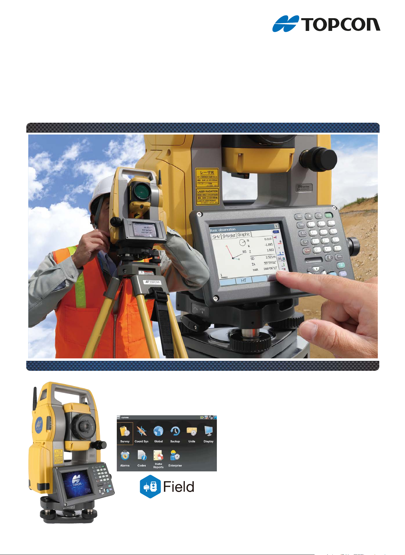
OS
OS-200
Onboard Station
series
For professionals like you
•
High performance EDM for rapid, repeatable measurements
• Modern, intuitive onboard MAGNET® Field software
• Convenient EDM trigger key
• Reflectorless laser measurement
Page 2
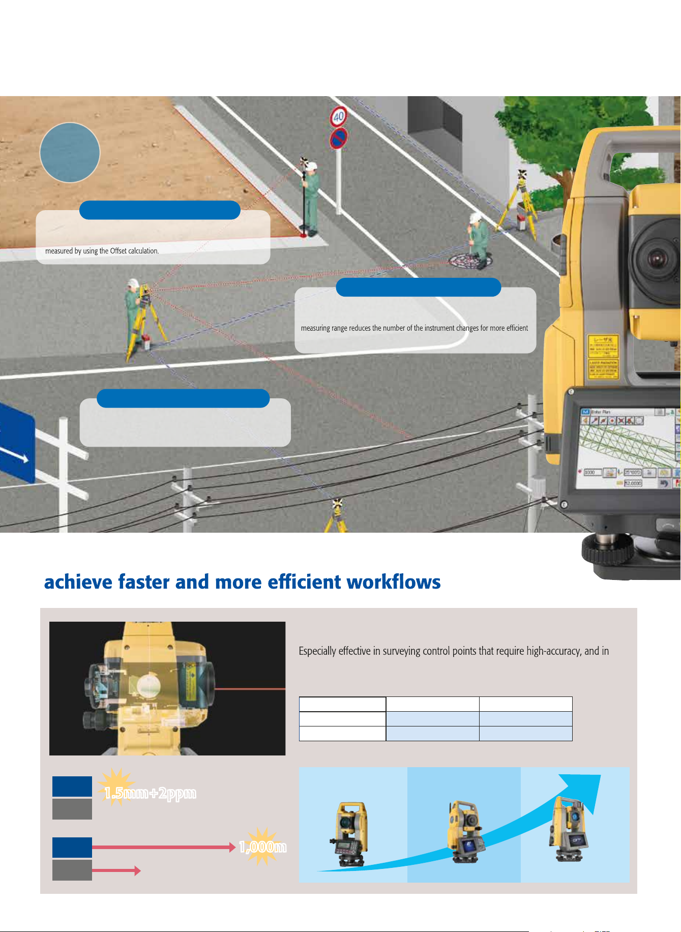
GM
Previous
Model
Previous
Model
1,000m1,000m
1.5mm+2ppm
1.5mm+2ppm
2.0mm+2ppm
500m
GM
Distance Measurement Accuracy (Prism Mode)
Measuring Range(Reflectorless Mode)
Accuracy
Distance
Professional results from basic to advanced applications
Survey
The trigger key, or measuring distance key, helps you perform topography quickly
while continuously viewing through the telescope. Also, the long distance
working time.
Topographic Survey
Adjust and correct closure errors for latitudes, departures, angles
and/or elevations directly from the MAGNET Field onboard software.
Traverse Adjustment
Quickly and easily calculate areas with the Area function. Determine the center
point for objects such as a columns or electrical poles which cannot be directly
Boundary and Cadastral Survey
T3
K1
T2
T4
Improve topography and stake out with features to
Distance Measurement Accuracy (Prism Mode)
OS-200
Previous
Measuring Range(Reflectorless Mode)
OS-200
Previous
Accuracy
1.5mm+2ppm1.5mm+2ppm
Model
Model
2.0mm+2ppm
500m
Distance
1,000m1,000m
Newly Designed High-Performance Class EDM
cross sectional surveying in large areas with reflectorless measurement mode.
All Features are at Top Class
Prism-Mode 1.5mm+2ppm 6,000m*
Reflectorless 2.0mm+2ppm 1,000m*
Accuracy
Measuring Range
* Good atmospheric condition
Total station Line up
Entry Model Onboard Model High-end Model
GM-100 OS-200 GT Series
Automatic collimation / tracking
Page 3

Construction
All the road stakeout information can be seen on one screen as you stake
anywhere along the road design in real-time. Be more productive with real-time
roads information.
Road/Cross-Sectional Survey
Collect points, lines, areas, cross sections, and surfaces including automatic topo
while within Topo Survey.
Topographic Survey
A complete solution for every type of layout and stakeout is included in the software.
Stake Points
IP.2
KA 2-1
No.10
KE 2-1
KE 2-2
KA 2-2
Guide Light System
Anybody can move to Stake Out Line easily.
Green and Red colored lights will show you
the direction to move.
Discover MAGNET Field features and benefits.
• Intuitive user interface
• Advanced roading tool set
• Vast library of Import / Export file formats
• Calculate, contour, and compare surfaces
• Surface staking with automatic Digital Terrain Model creation
• Colorized cut and fill indicators, as well as volume calculations
• Direct connectivity to your private Company Account for easy data
exchange and quick chat
• Microsoft Bing Maps
®
for real-time images behind your points,
lines, and imported design files
Move to right on
Green light
Target Key & Screw System
By using tangent screws for sighting,
you can measure a distance with a single-
productivity for sighting task such as Stake
Out, Topography, and Elevation Stakes.
Layout line
Move to left on
Red light
Page 4

OS
- Bluetooth® word mark and logos are registered trademarks owned by Bluetooth SIG, Inc. and any use of such marks by Topcon is under license.
- Other trademarks and trade names are those of their respective owners.
- Specifications may vary by region and are subject to change without notice.
- Bluetooth
®
word mark and logos are registered trademarks owned by Bluetooth SIG, Inc. and any use of such marks by Topcon is under license.
- Other trademarks and trade names are those of their respective owners.
- Specifications may vary by region and are subject to change without notice.
TOPCON CORPORATION
75-1 Hasunuma-cho, Itabashi-ku, Tokyo 174-8580, Japan
www.topcon.co.jp
<Contact to>
Topcon Singapore Positioning Pte. Ltd.
1 Jalan Kilang Timor,
#09-01 Pacific Tech Centre, Singapore 159303
Phone: (+65)6778-3456 Fax : (+65)6773-6550
Email : svy.regional@topcon.com.sg
Web : www.topcon.com.sg
TOPCON CORPORATION
75-1 Hasunuma-cho, Itabashi-ku, Tokyo 174-8580, Japan
Phone: (+81)3-3558-2993 Fax: (+81)3-3960-4214
www.topcon.co.jp
Your Local Authorized Dealer is:
Your Local Authorized Dealer is:
Standard Package Components
• OS main unit
• Battery (BDC72)
• Battery charger (CDC77)
• Power Cable
• Lens cap
• Lens hood
• Tool pouch
• Precision screwdriver
• Lens brush
• Adjusting pin×2
• Silicon cloth
• Quick manual
• USB flash drive(Manual)
• Laser caution sign-board
• Carrying case
• Carrying strap
SPECIFICATIONS
OS-201 OS-202
Telescope
Magnification / Resolving power 30x / 2.5"
Others Length: 171mm (6.7in.), Objective aperture: 45mm (1.8in.) (48mm
(1.9in.) for EDM), Image: Erect, Field of view: 1°30' (26m/1,000m),
Minimum focus: 1.3m (4.3ft.), Reticle illumination: 5 brightness levels
Angle measurement
Display resolution 0.5" / 1" (0.0001 / 0.0002gon, 0.002 / 0.005mil)
Accuracy (ISO 17123-3:2001) 1" 2"
Dual-axis compensator / Collimation compensation Dual-axis liquid tilt sensor, working range: ±6' (±111mgon) /
Collimation compensation available
Distance measurement
Laser output
Measuring range Reflectorless
(under average conditions
*1
*3
*2
) Reflective sheet
*4 *5
Reflectorless mode: Class 3R / Prism/sheet mode: Class 1
0.3 to 800m (2,620 ft.) / Under good conditions*6 : 1,000m (3,280ft.)
RS90N-K: 1.3〜500m、 RS50N-K: 1.3〜300m 、 RS10N- K: 1.3〜100m
Mini prism 1.3 to 500m (1,640ft.)
One prism
1.3 to 5,0 00m (4.3 to 16,400ft.) / Under good conditions *6: 1.3 to 6,000m (19,680 ft.)
Display resolution Fine/Rapid measurement 0.0001m(0.001ft. / 1/16in.) / 0.001m (0.005ft. / 1/8in.) (selectable)
*2
Accuracy
(ISO 17123-4:2001)
(D=measuring distance in mm)
Measuring time
OS, Interface and Data management
Operating system Windows Embedded Compact7
Display / Keyboard
Control panel location
Trigger key On right instrument support
*8
*9
Tracking/Road measurement
Reflectorless
Reflective sheet
*3
*4
Prism (1.5 + 2ppm x D) mm
0.001m (0.005f t. / 1/8in.) / 0.01m (0.1ft. / 1/2in.) (selectable)
(2 + 2ppm x D) mm
(2 + 2ppm x D) mm
Fine: 0.9s (initial 1.5s), Rapid: 0.6s (initial 1.3s), Tracking: 0.4s (initial 1.3s)
3.5inch, Transmissive TFT QVGA color LCD with LED backlight,
Touch screen, Automatic brightness control / 29 keys with backlight
On both faces (Face 2 is only touch screen display )
Data storage Internal memory 1GB internal memory (includes memory for program files)
Plug-in memory device USB flash memory
Interface Serial RS-232C, USB2.0 (Type A / mini B)
Bluetooth modem (Factory Option)
General
Guide light
Laser-pointer
*11
*11
*9
Bluetooth Class 1, Operating range: up to 10m
Green LED (524nm) and Red LED (626nm),
Operating range: 1.3 to 150m (4.3 to 490ft.)
Coaxial red laser using EDM beam
Calendar / clock function Yes
Levels
Graphic
6’(inner circle)
Circular level 10' / 2mm
Optical plummet Magnification: 3x, Minimum focus: 0.3m (11.8in.) from tribrach bot tom
Laser plummet (option)
Tribrach Detachable
Dust and water protection IP65 (IEC 60529:20 01)
Operating temperature
*11
Red laser diode (635nm±10nm), Beam accuracy: <=1.0mm@1.3m, Class 2 laser product
-20 to 60
Size (with handle) 191(W)x190(D)x348(H)mm
Instrument height 192.5mm from tribrach mounting surface
236mm +5/-3mm from tibrach bottom
Weight with battery & tribrach Approx. 5.7kg (12.3 lb.)
Power supply
Battery BDC72 Li-ion rechargeable bat ter y
Operating time(20
*1 IEC60825-1:Ed.2.0:2007 / FDA CDRH 21 CFR Part 1040.10 and 11
*2 Average conditions: Slight haze, visibility about 20km (12 miles), sunny periods, weak scintillation.
measuring objects, observation situations and environmental conditions.
*4 When the measuring beam's incidence angle is within 30° in relation to the reflective sheet target.
*5 Measuring range in temperatures of -30 to -20°C (-22 to -4°F) with Low Temperature models and 50 to 60°C (122 to 140°F) with High Temperature models: RS90N-K: 1.3 to
300m (4.3 to 980ft.), RS50N-K: 1.3 to 180m (4.3 to 590ft.), RS10N-K: 1.3 to 60m (4.3 to 190ft.)
*6 Good conditions: No haze, visibility about 40km (25 miles), overcast, no scintillation.
*7 Measuring range:0.3 to 200m
*8 Typical, under good conditions. Reflectorless measurement time may vary according to measuring objects, observation situations and environmental conditions.
*9 Usage approval of Bluetooth wireless technology varies according to country. Please consult your local oce or representative in advance.
*10 No obstacles, few vehicles or sources of radio emissions/interference in the near vicinity of the instrument, no rain.
*11 The laser-pointer and the guide light do not work simultaneously.
*12 Low Temperature models:-30 to 50 °C (-22 to 122°F) is available on built-to-order basis.
)
BDC72 Approx. 20hours (single distance measurement every 30 seconds)
*7
*10
*2
)F°041 ot 4-( C °
ot gnidrocca yrav yam ycarucca/egnar sselrotcelfeR .ssel ro .xl 000,03 si ecafrus derusaem no ssenthgirb nehW .)evitcelfer %09( ediS etihW draC yarG kadoK htiW .edom eniF 3*
Topcon Positioning Middle East and Africa FZE
P.O.Box 371028, LIU J-11, Dubai Airport Free Zone, Dubai, UAE
Phone : (+971)4-299-0203 Fax : (+971)4-299-0403
Email: marketing@topconpositioningmea.com
Website: www.topconpositioningmea.com
©2020 Topcon Corporation All rights reserved. TPMA-5082.ME.0221.E1
- Specifications may vary by region and are subject to change without notice.
- Bluetooth® word mark and logos are registered trademarks owned by Bluetooth SIG, Inc. and any use of such marks by Topcon is under license.
- Other trademarks and trade names are those of their respective owners.
Your Local Authorized Dealer is:
 Loading...