

Raymarine RAYCHART 420, RAYCHART 420D User Manual
Quick Reference Card - RayChart 420/420D Chartplotter
86051_1.p65 09/11/99, 10:451
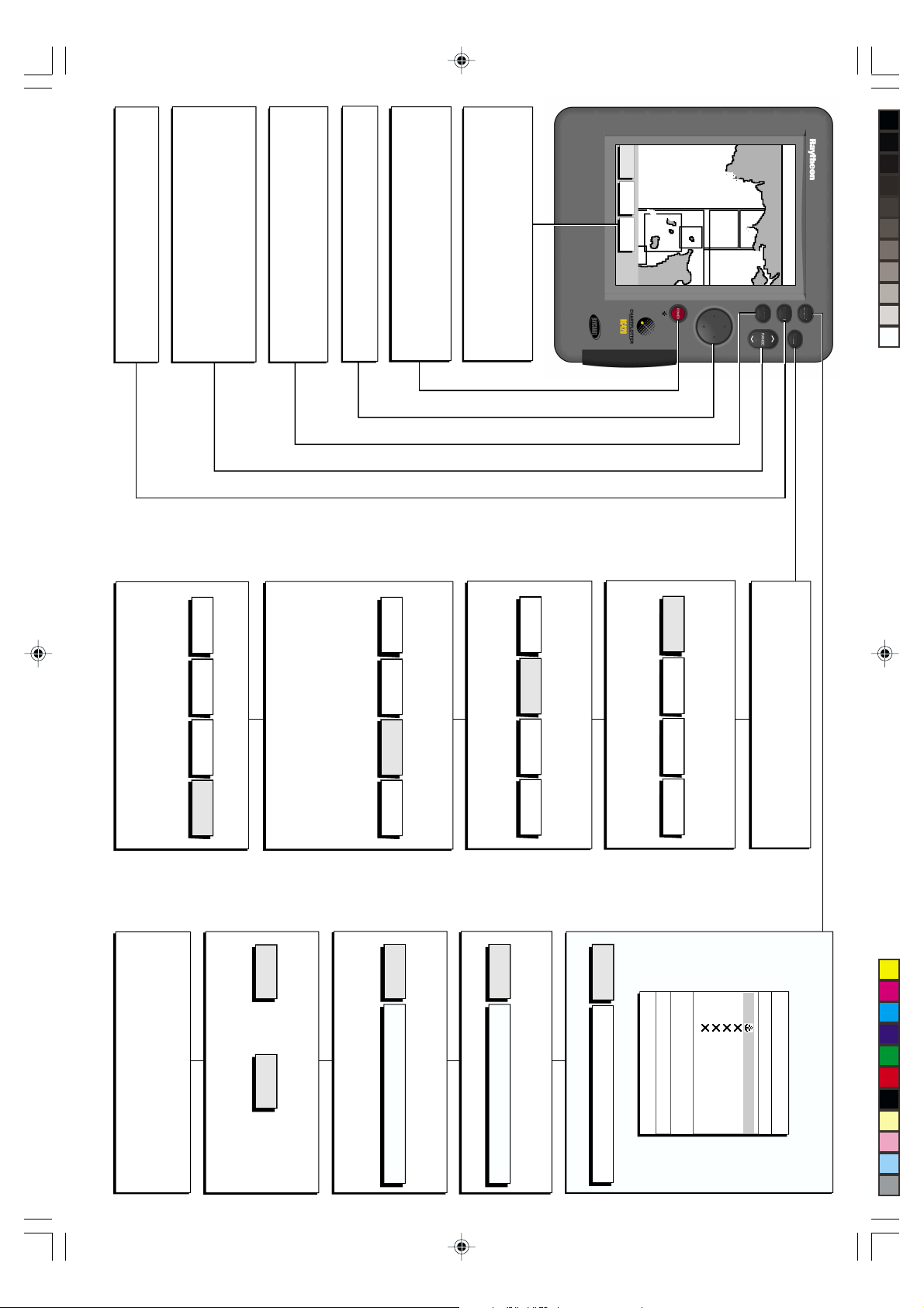
CLEAR
Cancels operation in progress and returns to previous display
Deletes a highlighted item
- Press bottom of key to decrease the chart range
- Press and hold to change the scale rapidly
RANGE
Adjusts chart scale
Displayed vertical distances shown in Status Bar (top of screen)
- Press top of key to increase the chart range
ENTER
Confirms selection and (if appropriate) clears current
functions. It either performs the selected task and
accepts changes, or confirms selection of more options
Trackpad
Controls cursor position on screen and highlights functions
Press once to adjust lighting & contrast.
Press and hold for 3 seconds to turn off display
by highlighting then pressing ENTER
POWER
Press and hold until unit beeps to turn on display
Function Bar
Press ENTER to display primary Function Bar (as shown here)
Use trackpad to highlight function then ENTER to select
Elipses (...) after the text indicate further options available
FIND SHIP ROUTES WAYPOINTS
GUERNSEY
JERSEY
PORTB
ALDERNEY
LA HAGUE
SALCOMBE
CAP DE
ENPORT
PLYMOUTH
TORQUAY
DARTMOUTH
EXMOUTH
PORTLAND
HARBOUR
ISLE O
128 nm
TEIGNMOUTH
EXETER
TOPSHAM
POS 1°35.636'W
RNG 40.91nm
CLEAR
ENTER
CSR 48°30.367'N
BRG 231°T
GOTO
MOB
PAGE
GPS SET UP and Status
Press ENTER to implement change
SYSTEM
SET UP
SET UP
CHART
SET UP
TRACK
SET UP
GPS
Man OverBoard (MOB)
Press and hold GOTO for at least two seconds
- Waypoint 0999 is created and marked with MOB symbol
- Status Bar shows bearing and range to the MOB position,
elapsed time since initiated and Course Over Ground data
Press ENTER to stop the GOTO
- The dotted line from your vessel to the target disappears
Press ENTER to convert to a (reversed) route
Select STOP GOTO or STOP FOLLOW (as appropriate)
STOP
GOTO
Use horizontal trackpad movements to highlight GPS SET UP
Press ENTER to display the GPS Status page
Press ENTER to display the Differential GPS Set Up page (RC420D)
Use vertical trackpad movements to select parameter
Use horizontal trackpad movements to change setting
Use horizontal trackpad movements to highlight TRACK OFF
Press ENTER to start track - text indicates TRACK ON
SMARTROUTE
To convert a track to a route, select MAKE INTO ROUTE
To stop a GOTO
Press GOTO to display Function Bar (or move cursor over any
waypoint in the current route)
or
Use horizontal trackpad movements to select INTERVAL
Use vertical trackpad movements to change setting
Press ENTER to save value
- The Port List is displayed
Use trackpad to highlight required port
Press ENTER to start the GOTO
Press ENTER to select
SYSTEM
SET UP
SET UP
CHART
SET UP
TRACK
SET UP
GPS
GOTO PORT
Press GOTO to display Function Bar
Select GOTO PORT function
GOTO
PORT
TRACKPAD SELECTS PORT, "ENTER"
STARTS GOTO, "CLEAR" TO QUIT
Press ENTER to place a temporary waypoint and start the GOTO
CURSOR
GOTO
MOVE CURSOR, "ENTER" TO START
GOTO CURSOR, "CLEAR" TO QUIT
Use horizontal trackpad movements to change setting
Press ENTER to implement change
TRACK SET UP
Use horizontal trackpad movements to highlight TRACK SET UP
Use vertical trackpad movements to select parameter
Press ENTER to select
SYSTEM
SET UP
SET UP
CHART
SET UP
TRACK
SET UP
GPS
Press ENTER to implement GOTO WAYPOINT function
GOTO CURSOR
Press GOTO to display Function Bar
Select GOTO CURSOR function
SYSTEM
SET UP
SET UP
CHART
SET UP
TRACK
SET UP
GPS
Use trackpad to highlight required waypoint
WAYPOINT
GOTO
DATE
POSITION
TRACKPAD SELECTS WPT, "ENTER"
STARTS GOTO, "CLEAR" TO QUIT
BRG _186°T RNG _21.0NM
----
Use vertical trackpad movements to select parameter
Use horizontal trackpad movements to change setting
Press ENTER to implement change
CHART SET UP
Use horizontal trackpad movements to highlight CHART SET UP
SYSTEM SET UP
Use horizontal trackpad movements to highlight SYSTEM SET UP
Press ENTER to select
PAGE - Selects Setup options and display mode.
Press to display Setup Function Bar and use horizontal trackpad
movements to highlight required option. Press ENTER to select
Press PAGE again repeatedly to cycle through display modes
GOTO WAYPOINT
Press GOTO to display Function Bar
Select GOTO WAYPOINT function to display Waypoint List
SYMBOL NAME
WAYPOINT LIST
86051_1A
FOLLOW
STOP
TIME
--:--
WAYPOINT 004
WAYPOINT 005
50°21,966'N
001°20,368'W
WAYPOINT 001
WAYPOINT 002
WAYPOINT 003
86051_1.p65 09/11/99, 10:452
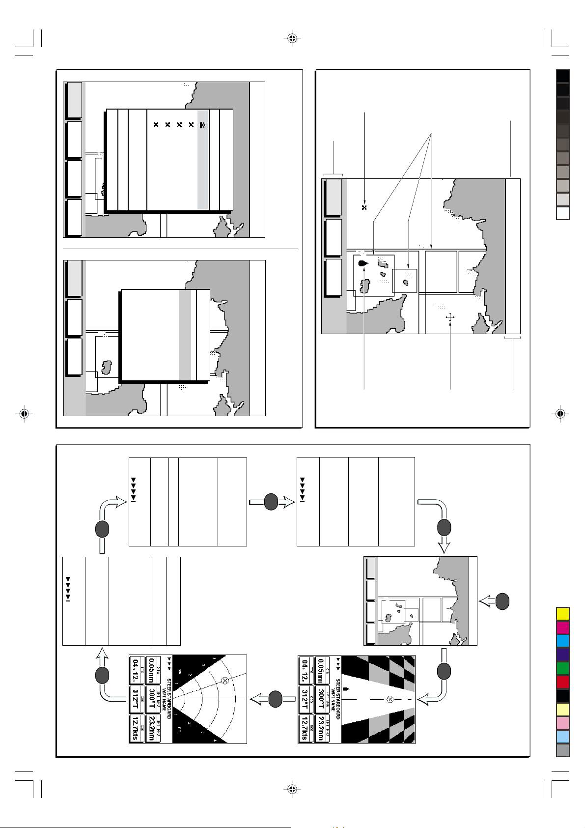
Chart Range
WAYPOINT
GOTO
WAYPOINT
EDIT
MAKE NEW
WAYPOINT
WPT/ROUTE
TRANSFER
ENPORT
PLYMOUTH
SALCOMBE
POSITION 50°21.966'N
001°20.368'W
BRG 186° T RNG 21.0 nm
DATE 13/10/99 TIME 15:30
TORQUAY
DARTMOUTH
WPT 001
WPT 002
WPT 003
WPT 004
WPT 005
GUERNSEY
JERSEY
PORTB
ALDERNEY
LA HAGUE
CAP DE
PORTLAND
HARBOUR
ISLE O
TEIGNMOUTH
128 nm
EXETER
SYMBOL NAME
TOPSHAM
EXMOUTH
POS 1°35.636'W
WAYPOINT LIST
RNG 40.91nm
Waypoint List Route List
Press ENTER to display Primary Function Bar
Select WAYPOINTS
Select WAYPOINT LIST
CSR 48°30.367'N
BRG 231°T
Waypoint
Primary Function Bar
Press ENTER to display
Press CLEAR to remove
FIND SHIP ROUTES WAYPOINTS
Chart Boundary -
Indicates further
detail is available inside.
Shown when using
Navionics
fi
Microchart card.
ENPORT
PLYMOUTH
SALCOMBE
TORQUAY
DARTMOUTH
TEIGNMOUTH
TOPSHAM
EXMOUTH
Chart Display
128 nm
EXETER
CSR 48°30.367'N
POS 1°35.636'W
GUERNSEY
Press ENTER to display Primary Function Bar
Select ROUTES, then select MORE and press ENTER
ROUTE
SHOW
ERASE
ROUTE
5 -
4 -
3 -
SALCOMBE
1 ROUTE 01
2 -
ENPORT
TEIGNMOUTH
PLYMOUTH
TORQUAY
DARTMOUTH
EXMOUTH
ROUTE LIST
EXETER
TOPSHAM
Select ROUTE LIST and press ENTER
128 nm
CSR 48°30.367'N
POS 1°35.636'W
JERSEY
PORTB
ALDERNEY
CAP DE
LA HAGUE
PORTLAND
HARBOUR
ISLE O
BRG 231°T
RNG 40.91nm
GUERNSEY
ROUTE
NAME
JERSEY
PORTB
Navigation Data
to display
Press
COG 230° T TIME 13:29 12/12/99
SOG 6.8 Kts TTG 01:03
XTE 0.5 nm ETA 14:32 12/12/99
STEER STARBOARD
RNG 12.4 nm
ALDERNEY
HARBOUR
CAP DE
LA HAGUE
WAYPOINT 001
BRG 234° T GPS FIX
RNG 2.4 nm TIME 14:32 12/12/99
STEER STARBOARD
SOG 6.8 Kts
ROUTE
WAYPOINT
BRG 234° T
WPT 001 TO WPT 002
ROUTE 01
PORTLAND
RNG 40.91nm
ISLE O
COG 230° T
POSITION
50°45 .000 N
001°06 .000 W (c)
BRG 231°T
Press to display
Time/Date
information
PAGE
Note: In any display mode,
press GOTO to return
to chart display
Vessel's
Position
ETA (WAYPOINT) 13:37 26/01/99
TTG (WAYPOINT) 01:03
ETA (ROUTE) 14:32 27/01/99
TTG (ROUTE) 34:03
STEER STARBOARD
TIME 12:34
DATE 26/01/99
SETUP
SETUP
SETUP
SETUP
SUNSET 21.34 TODAY
AT POSITION (USER SELECTED)
50°45 .000 N
001°06 .000 W (c)
SYSTEM
CHART
GUERNSEY
JERSEY
PORTB
ALDERNEY
TRACK
GPS
SUNRISE 06.23
Set Up functions
to return to
PLYMOUTH
SALCOMBE
DARTMOUTH
HARBOUR
CAP DE
LA HAGUE
Cursor
Press
PAGE
ENPORT
TORQUAY
EXMOUTH
PORTLAND
ISLE O
128 nm
TEIGNMOUTH
EXETER
TOPSHAM
POS 1°35.636'W
RNG 40.91nm
CSR 48°30.367'N
BRG 231°T
Status Bar
Display Modes
Press PAGE to display Set Up functions
From Chart Display
PAGE
D86051_1b
Waypoint Data
to display
PAGEPAGE
Press
Press to display
BDI
PAGE
to display CDI
Press
PAGE
 Loading...