

Page 1

2017 NAVIGATION
SYSTEM
OWNER’S MANUAL
For your safety, read carefully and keep in this vehicle.
Page 2

NISSAN CONSUMER AFFAIRS DEPARTMENT
For assistance or inquiries about the NISSAN
warranty, service or general questions, contact
the NISSAN Consumer Affairs Department at:
For U.S. customers
Nissan North America, Inc.
Consumer Affairs Department
P.O. Box 685003
Franklin, TN 37068-5003
1-800-NISSAN-1
(1-800-647-7261)
For Canadian customers
Nissan Canada Inc.
5290 Orbitor Drive
Mississauga, Ontario L4W 4Z5
1-800-387-0122
NISSANCONNECTSMHELPDESK
CONTACT INFORMATION
For assistance or inquiries about the NissanConnect
SM
, or to order updated map data,
contact the NISSAN NAVIGATION SYSTEM
HELPDESK at:
For U.S customers
. E-MAIL: nissan-navi-info@here.com
. WEB SITE:http://www.NissanNavigation.
com
. PHONE: 1-888-661-9995
For Canadian customers
. WEB SITE: www.nissan.ca
. PHONE: 1-800-387-0122 (option 4)
FOREWORD
Thank you for purchasing a NISSAN vehicle.
This user’s manual is for NissanConnect
SM
and
the systems linked to NissanConnect
SM
offered
in your NISSAN vehicle.
Please read this manual carefully to ensure safe
operation of NissanConnect
SM
.
. Because of possible specification changes
and optional equipment, some sections of
this manual may not apply to your vehicle.
. All information, specifications and illustra-
tions in this manual are those in effect at the
time of printing. NISSAN reserves the right to
change specifications or design at any time
without notice.
. Do not remove this manual from the vehicle
when selling this vehicle. The next user of the
system may need the manual.
Page 3

Table of Contents
Control buttons
and functions ............................. 2-2
Starting system ......................... 2-5
Touch panel operation ............ 2-5
Navigation system
status screen ............................. 2-7
Shortcut menu........................... 2-7
Map menu .................................. 2-8
Display View Bar ...................... 2-8
How to input letters
and numbers ............................ 2-10
Functions disabled
while driving ............................. 2-11
Map types................................... 3-2
Displaying current
vehicle location ......................... 3-4
Moving map ............................... 3-5
Changing scale of map .......... 3-6
Change map .............................. 3-7
Setting split screen .................. 3-8
Map view settings .................... 3-8
Setting information
on map ...................................... 3-11
Traffic information on map.... 3-12
Changing region ....................... 4-2
Destination screen ................... 4-3
Finding address ........................ 4-7
Finding points of interest........ 4-8
Setting home
as destination .......................... 4-10
Finding nearby place ............. 4-11
Searching from
Stored Locations .................... 4-11
Searching from history .......... 4-12
Using Journey Planner .......... 4-12
Setting intersection ................ 4-13
Setting
freeway entrance/exit............. 4-14
Setting city center .................. 4-14
Setting by phone number .... 4-15
Setting from stored routes.... 4-15
Searching by connecting
Data Center ............................. 4-16
Setting by NissanConnect
1 Introduction
How to use this manual.......... 1-2
Safety information..................... 1-3
Laser product ............................ 1-4
Customer assistance ............... 1-5
2 Getting Started
3 Map operation
4 Setting destination
Services .................................... 4-17
Setting point on map............. 4-18
Procedures after
setting route............................. 4-18
SM
5 Route guidance
About route guidance ............. 5-2
Guidance screen settings ...... 5-7
Canceling Route ....................... 5-7
Page 4

Route menu screen ................. 5-7
Storing location......................... 6-2
Storing route.............................. 6-3
Storing avoid area .................... 6-4
Editing stored information ...... 6-5
Deleting stored item ................ 6-9
Transferring information to/
from address book ................. 6-11
Voice recognition ...................... 8-2
Editing route .............................. 5-8
Recalculating route ................ 5-11
Searching for detour route
using traffic information ........ 5-11
Displaying Turn List................ 5-13
Route guidance settings ...... 5-13
NissanConnect
Services .................................... 7-14
Settings screen ....................... 7-24
Navigation settings................. 7-30
SM
8 Voice recognition
6 Storing a location/route
9 General information
7 Information and settings
Information screen.................... 7-2
SiriusXM Traffic information ... 7-4
SiriusXM Travel Link
.............. 7-7
Current vehicle location .......... 9-2
Route calculation ...................... 9-6
Route guidance......................... 9-8
Map data .................................. 9-10
How to handle the
SD card .................................... 9-14
10 Troubleshooting guide
System unit .............................. 10-2
Navigation................................. 10-3
Voice recognition ................. 10-11
Page 5

1 Introduction
How to use this manual ........................................................... 1-2
For safe operation ............................................................... 1-2
Reference symbols ............................................................. 1-2
Screen illustrations .............................................................. 1-2
Safety information ..................................................................... 1-3
Laser product ............................................................................ 1-4
Trademarks ......................................................................... 1-4
Customer assistance ............................................................... 1-5
Page 6
1. Introduction
HOW TO USE THIS MANUAL
This manual uses special words, symbols, icons
and illustrations organized by function.
Please refer to the following items and familiarize
yourself with them.
FOR SAFE OPERATION
WARNING
This is used to indicate the presence of a
hazard that could cause death or serious
personal injury. To avoid or reduce the
risk, the procedures must be followed
precisely.
CAUTION
This is used to indicate the presence of a
hazard that could cause minor or moderate personal injury or damage to your
vehicle. To avoid or reduce the risk, the
procedures must be followed carefully.
NOTE:
Indicates items that help you understand
and maximize the performance of your
vehicle. If ignored, they may lead to a
malfunction or poor performance.
REFERENCE SYMBOLS
INFO:
This indicates information that is necessary for
efficient use of your vehicle or accessories.
Reference page:
This indicates the title and page that you should
refer to.
[]:
This indicates a key/item displayed on the
screen.
Voice Command:
This indicates an operation by voice command.
SCREEN ILLUSTRATIONS
Icons and menu items displayed on the screen
may be abbreviated or omitted from the screen
illustrations when appropriate. The omitted icons
and menu items are described as dotted lines as
illustrated.
1-2
Page 7
. To operate the system, first park the
vehicle in a safe location and set the
parking brake. Operating the system
while driving can distract the driver
and may result in a serious accident.
. Exercise extreme caution at all times
so full attention may be given to
vehicle operation. If the system
doesn’t respond immediately, please
be patient and keep your eyes on the
road. Inattentive driving may lead to a
crash resulting in serious injuries or
death.
. Do not disassemble or modify this
system. If you do, it may result in
accidents, fire or electrical shock.
. If you notice any foreign objects in
the system hardware, spill liquid on
the system or notice smoke or a smell
coming from it, stop using the system
immediately and contact a NISSAN
dealer. Ignoring such conditions may
lead to accidents, fire or electrical
shock.
. Do not rely on route guidance alone.
Always be sure that all driving maneuvers are legal and safe in order to
avoid accidents.
1. Introduction
SAFETY INFORMATION
The navigation system is primarily designed to
help you support your pleasant driving as
outlined in this manual. However, you, the driver,
must use the system safely and properly.
Information and the availability of services may
not always be up to date. The system is not a
substitute for safe, proper and legal driving.
Before using the system, please read the
following safety information. Always use the
system as outlined in this manual.
WARNING
CAUTION
. Some jurisdictions may have laws
limiting the use of video screens
while driving. Use this system only
where it is legal to do so.
. Extreme temperature conditions [be-
low í48F(í208C) and above 1588F
(708C)] could affect the performance
of the system.
. The display screen may break if it is
hit with a hard or sharp object. If the
display screen breaks, do not touch
it. Doing so could result in an injury.
NOTE:
Do not keep the system running with the
engine stopped. Doing so may discharge
the vehicle battery. When you use the
system, always keep the engine running.
1-3
Page 8

1. Introduction
LASER PRODUCT
This NissanConnectSMis certified as a Class 1
laser product.
The system complies with DHHS Rules 21 CFR
Chapter 1, Subchapter J.
WARNING
. Do not disassemble or modify this
system. There are no user serviceable
parts in the system.
. If maintenance, adjustments and op-
erations other than those specified in
this manual are attempted, injury due
to laser radiation and exposure could
occur.
TRADEMARKS
Required SiriusXM Satellite Radio and SiriusXM
Traffic monthly subscriptions are sold separately.
SiriusXM Traffic are only available in select
markets. For more information,
see www.siriusxm.com/siriusxmtraffic
Required SiriusXM Satellite Radio and SiriusXM
Travel Link monthly subscriptions are sold
separately. SiriusXM Travel Link is only available
in select markets. For more information,
see www.siriusxm.com/travellink
Google
C
*
2012 Google Inc. All rights reserved. Google
Calendar
mark of Google Inc.
TM
calendaring application is a trade-
1-4
Page 9

CUSTOMER ASSISTANCE
For assistance or inquiries about the NISSAN
Navigation System, or to order updated map
data, contact the NISSAN NAVIGATION SYSTEM HELPDESK. See the contact information
on the inside front cover of this manual.
1. Introduction
1-5
Page 10

1. Introduction
MEMO
1-6
Page 11

MEMO
1. Introduction
1-7
Page 12

1. Introduction
MEMO
1-8
Page 13

2 Getting Started
Control buttons and functions ............................................... 2-2
How to handle display ........................................................ 2-2
Control panel ........................................................................ 2-3
Multi-function controller ..................................................... 2-4
Steering-wheel switches ................................................... 2-4
Starting system .......................................................................... 2-5
Start-up screen .................................................................... 2-5
Touch panel operation ............................................................. 2-5
Operating menu screen ..................................................... 2-6
Scrolling message or list ................................................... 2-6
Selecting item ...................................................................... 2-7
Adjusting volume and settings ....................................... 2-7
Navigation system status screen .......................................... 2-7
Shortcut menu ........................................................................... 2-7
Edit shortcut menu ............................................................ 2-8
Map menu .................................................................................. 2-8
Display View Bar ...................................................................... 2-8
Customizing the Display View Bar ............................. 2-10
How to input letters and numbers ..................................... 2-10
Character (letters and numbers) input screen ........ 2-10
Functions disabled while driving ........................................ 2-11
Page 14
. To clean the display, stop the vehicle
in a safe location.
. Clean the display with the ignition
switch in the OFF position. If the
display is cleaned while the ignition
switch is in the ON position, unintentional operation may occur.
. When cleaning the display, never use
a rough cloth, alcohol, benzine, thinner or any kind of solvent or paper
towel with a chemical cleaning agent.
Doing so will cause scratches or
deterioration of the panel.
. Do not splash any liquid such as
water or car fragrance on the display.
Contact with liquid will cause the
system to malfunction.
To clean the display screen, use a dry, soft cloth.
If additional cleaning is necessary, use a small
amount of neutral detergent with a soft cloth.
Never spray the screen with water or detergent.
Dampen the cloth first, then wipe the screen.
2. Getting Started
CONTROL BUTTONS AND
FUNCTIONS
Designs and button layout may vary depending
on the specifications and the model.
HOW TO HANDLE DISPLAY
The display is a liquid crystal display and should
be handled with care.
WARNING
Never disassemble the display. Some
parts utilize extremely high voltage.
Touching them may result in serious
personal injury.
Characteristics of liquid crystal display
. If the temperature inside the vehicle is
especially low, the display will stay relatively
dim or the movement of the images may be
slow. These conditions are normal. The
display will function normally when the
interior of the vehicle has warmed up.
. Some pixels in the display are darker or
brighter than others. This condition is an
inherent characteristic of liquid crystal display, and it is not a malfunction.
2-2
. A remnant of the previous display image may
remain on the screen. This screen burn is
inherent in display, and it is not a malfunction.
Maintenance of display
CAUTION
Page 15
CONTROL PANEL
1
<CLIMATE>:
*
Push to display the screen for air conditioner operations.
Refer to the vehicle Owner’s Manual.
2
<CAMERA> (models with Around View
*
Monitor):
Push to operate the Around View Monitor.
Refer to the vehicle Owner’s Manual.
<
> (models without Around View
Monitor):
Push to operate hands-free phone.
Refer to the vehicle Owner’s Manual.
3
<APPS>:
*
Push to display the available Apps.
Refer to the vehicle Owner’s Manual.
4
<NAVI>:
*
Push to display the navigation menu.
“Destination screen” (page 4-3)
5
Multi-function controller:
*
Push to select an item on the screen, select
the highlighted item, or scroll the map on the
screen, etc.
“Multi-function controller” (page 2-4)
6
<STATUS>:
*
Push to display the current setting of the
vehicle information, air conditioner, audio
and navigation route information.
7
<INFO>:
*
Push to display the information menu.
“Information screen” (page 7-2)
2. Getting Started
8
< >, <+>/<->:
*
Push <
ness to the daytime mode or the nighttime
mode, and to adjust the display brightness
level using the multi-function controller
while the indicator is displayed at the
bottom of the screen. Push and hold
<
The display brightness can also be adjusted
using <+> or <í>.
9
<AUDIO>:
*
Push to operate the audio system.
Refer to the vehicle Owner’s Manual.
10
< BACK>:
*
Push to return to the previous screen. In a
settings screen, this button is also used to
apply the setting.
11
<MAP>:
*
Push to display the current location map
screen.
12
<SETTING>:
*
Push to access the system settings.
13
<VOICE>:
*
Push to repeat the voice guidance for a
guide point.
> to switch the display bright-
> to turn the display on and off.
2-3
Page 16

2. Getting Started
MULTI-FUNCTION CONTROLLER
4
Center dial:
*
Turn to highlight an item on the screen or
adjust a setting.
The center dial can also be used to adjust
the map scale.
STEERING-WHEEL SWITCHES
1
<ENTER>:
*
Push to select the highlighted item on the
screen.
If this button is pushed while a map is
displayed, the map menu screen is displayed.
“Map menu” (page 2-8)
2
Main directional buttons:
*
Use to move across the map, select an item
on the screen or adjust a setting (volume,
brightness, etc.) .
3
Additional directional buttons:
*
Use to move across the map or select an
item on the character input screen.
2-4
1
<ENTER>:
*
Tilt to highlight an item on the screen or
adjust a setting. Push to select the highlighted item.
If this button is tilted up while the audio
function is activated and the map or status
screen is displayed, the audio system can
be operated.
If this button is pushed while a map is
displayed, the map menu screen is displayed.
“Map menu” (page 2-8)
2
< >:
*
Push to return to the previous screen.
This button is used for the vehicle informa-
tion display operation, also.
Page 17
2. Getting Started
Refer to the vehicle Owner’s Manual.
3
<+ í>:
*
Use to adjust the volume. These buttons
have the same function as that of <VOL>
on the audio system.
Refer to the vehicle Owner’s Manual.
4
<SOURCE> :
*
Use to switch the audio mode (source).
Refer to the vehicle Owner’s Manual.
5
< > (TALK):
*
Push to start a voice recognition session.
During a voice recognition session, pushing
this button cancels the voice guidance and
you can speak a voice command immediately.
Push and hold this button to end a voice
recognition session.
6
< >:
*
Push to display the phone mode screen.
Refer to the vehicle Owner’s Manual.
7
< >:
*
This button is used for the vehicle information display operation.
Refer to the vehicle Owner’s Manual.
STARTING SYSTEM
The system starts when the ignition switch is
pushed to the “ACC” or “ON” position.
START-UP SCREEN
For this system, when the ignition switch is
pushed to the “ACC” or “ON” position, the startup screen is displayed.
Touch [OK] after reading and agreeing to the
message. If you do not agree to the message,
some of the functions will be disabled.
NOTE:
Do not keep the navigation system on with
the engine stopped. Doing so may discharge the vehicle battery. When you use
the navigation system, always keep the
engine running.
INFO:
Once you select [Decline] on the start-up screen,
the [OK]/[Decline] screen will not be displayed
for 30 days.
TOUCH PANEL OPERATION
Basic touch panel operation methods are
explained here.
. Touch
Select and execute the selected key on the
screen.
2-5
Page 18
2. Getting Started
. Swipe
Menu screen pages will skip to the next
page.
. Drag
Drag up or down to scroll. You can scroll up
and down a list screen.
Various further operations are possible for a map
screen. For detailed operations of the map
screen, refer to the map operation section.
“Operating with touch panel operation”
(page 3-4)
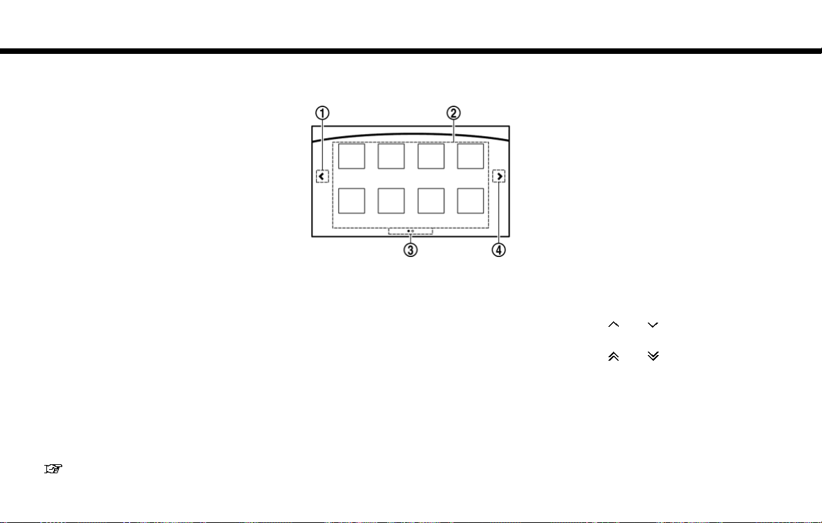
OPERATING MENU SCREEN
1
Touch [<] to scroll to the previous page.
*
2
Touch a preferred icon to execute a function
*
and display the next screen.
3
Indicates the position of the currently
*
displayed page out of the total number of
available pages.
4
Touch [>] to scroll to the next page.
*
A swipe gesture can also be used to move
quickly between screens.
SCROLLING MESSAGE OR LIST
1
Drag the scroll bar up or down to scroll the
*
message or list up or down.
2
Touch a preferred item.
*
3
If a listed item name is not completely
*
displayed (due to length), touch [>]to
display the hidden part of the name.
4
Touch [ ]or[ ] to scroll the message or
*
list one item at a time.
Touch [
]or[ ] to skip to the next page.
2-6
Page 19
2. Getting Started
SELECTING ITEM
When the item is touched, it is executed and the
next screen is displayed.
Touch [
] to return to the previous screen.
ADJUSTING VOLUME AND SETTINGS
Set the volume and brightness.
Touch adjustment keys, such as [+]/[-], [L]/[R],
etc., to adjust each item. Each time a key is
touched, the indicator moves along the bar.
NAVIGATION SYSTEM STATUS
SCREEN
By pushing <STATUS>, the current status of
the system can be displayed.
INFO:
There are different status screens displayed
depending on various factors, such as the
currently active mode, whether a destination
has been set or not, etc.
When a route to the destination is set and the
audio system is on, a screen similar to the one
above appears.
Touching [<]/[>] can switch air conditioner
status screen, navigation route information
screen and fuel economy information screen.
When no route is set, a compass and the current
location is displayed instead of the route
information.
SHORTCUT MENU
Push <ENTER> or touch [ ] while the current
location map screen is displayed to display the
shortcut menu screen.
The items on the shortcut menu can be
customized to your preference.
Available items:
. Audio Source
. Audio List
. Call History
. Phonebook
. Cancel Route
. Nearby Places
. Store Location
. View Settings
2-7
Page 20
2. Getting Started
. Select Add/Edit
. (Blank)
EDIT SHORTCUT MENU
The following procedure can edit or sort the
shortcut menu.
1. Select [Select Add/Edit] to register a new
item to the menu, or to change an existing
menu item.
2. Select preferred setting.
. [Change Order]
Change the order in which shortcut menu
items are shown. Touch and hold the [
displayed next to the item you wish to
relocate. Drag the icon to the position in
the list where you wish to insert the item.
. [Edit Shortcut Items]
Edit items to be displayed in the shortcut
menu.
MAP MENU
While scrolling the map screen, push <ENTER>
or touch [
Available items:
]
. New Destination
. Show Current Location
. Store Location
. Nearby Places
. Delete Stored Location
] to display the Map Menu.
DISPLAY VIEW BAR
Various map information screens can be shown
by selecting from the Display View Bar.
When the screen displays the map, push
<MAP> to show the Display View Bar.
Select an icon in the Display View Bar. The
current view will changed and the Display View
Bar will be closed.
The following display views are available.
Viewing Split Map:
2-8
Page 21
2. Getting Started
The map can be displayed on a split screen.
Each screen can be adjusted independently.
Viewing Intersection:
The next intersection is always displayed.
INFO:
When no route is set, the intersection screen is
not displayed and the map is displayed on the full
screen.
Viewing Turn List:
This displays the turn list on the left screen.
When approaching a guide point, the left screen
automatically switches to an enlarged view of the
intersection.
INFO:
When no route is set, the turn list screen is not
displayed and the map is displayed in the full
screen.
Viewing Where am I ?:
This displays the information about the current
vehicle location.
Viewing Turn by Turn:
This displays a turn point when driving according
to route guidance.
INFO:
When no route is set, a turn point screen is not
displayed and the map is displayed in the full
screen.
Viewing Fuel Economy
Fuel economy information can be checked while
driving.
2-9
Page 22

2. Getting Started
Viewing Eco Drive Report:
Your driving score will be displayed in real time,
with 100 points designated as the score for ideal
eco-driving.
For improving your score:
. When starting off, depress the accelerator
gently.
. When cruising, accelerate and decelerate as
little as possible.
. When decelerating, releasing the accelera-
tor early.
CUSTOMIZING THE DISPLAY VIEW
BAR
The menu icons on the Display View Bar can be
customized to your preference.
1. Push <SETTING> and touch [Navigation] to
display the navigation setting screen.
2. Touch [Map & Display View] and touch
[Change Order].
3. Change the order of the icons to be
displayed on the Display View Bar. Touch
and hold the [
you wish to relocate. Drag the icon to the
position in the list where you wish to insert
the item.
] displayed next to the item
HOW TO INPUT LETTERS AND
NUMBERS
CHARACTER (letters and numbers)
INPUT SCREEN
Alphanumeric characters are entered using the
keyboard screen.
1
Touch a character on the displayed key-
*
board. The selected character is entered.
2
Entered characters are displayed here.
*
3
Touch [Delete] to delete the last character
*
entered.
Touch and hold [Delete] to delete all the
characters entered.
2-10
Page 23

4
The symbol keys are displayed by touching
*
[Symbols]. The alphabet keys are displayed
by touching [A-Z].
5
Touch [Space] to enter a space.
*
6
Touch [OK] or [List] to finalize your input.
*
INFO:
. Touch [CAPS] to toggle uppercase and
lowercase characters on the keyboard
screen.
. Touch [
input position.
]or[ ] to move the character
2. Getting Started
FUNCTIONS DISABLED WHILE
DRIVING
Example
2-11
Page 24

2. Getting Started
To help ensure safe driving, some functions
cannot be operated or have limited operation
while the vehicle is in motion.
The on-screen text and keys for these restricted
functions will be “grayed-out” or muted and
cannot be selected while driving. In some cases,
a screen message will appear indicating a
restricted function.
Restricted functions while driving include:
. Character (letter and number) input screen.
. Scrolling and viewing of certain list screens
. Displaying detail information and touching
item on the information screen
. Adding/editing home location, address book
entries and current route
. Making a call by dial number and handset
phonebook
. Setting phone, NissanConnect
and Bluetooth
These functions will become available again
when the vehicle is not in motion.
Some of the destination setting functions that
become unavailable while driving can be operated by voice recognition system. Available voice
commands may differ depending on the language setting.
functions
SM
Services
2-12
Page 25

3 Map operation
(3D) map .......................................................... 3-5
Changing scale of map ............................................................ 3-6
Touch panel operation ........................................................ 3-6
Multi-function controller operation ................................ 3-6
Map scale ............................................................................ 3-6
Change map .............................................................................. 3-7
Setting split screen .................................................................. 3-8
Map view settings .................................................................... 3-8
Setting information on map ................................................. 3-11
Displaying facility icons ................................................. 3-11
Displaying map scrolling information ......................... 3-11
Road color ....................................................................... 3-11
Traffic information on map ................................................... 3-12
Map types ................................................................................... 3-2
2D map .................................................................................. 3-2
Birdview
Building graphics ................................................................. 3-4
Displaying current vehicle location ....................................... 3-4
Operating with control panel ............................................ 3-4
Operating with touch panel operation ........................... 3-4
Moving map ................................................................................ 3-5
2D map .................................................................................. 3-5
Birdview
TM
(3D) map .......................................................... 3-3
TM
Page 26
3. Map operation
MAP TYPES
Two types of map views are available: 2D map
and Birdview
TM
(3D) map.
2D MAP
The 2D map displays the map in a twodimensional environment similar to a road map.
Screen information:
1
*
2
*
Arrow:
Indicates the turning direction of the next
guide point. Distance to the guide point is
also indicated above the arrow.
Traffic indicator:
Displays the reception condition of traffic
information transmitted from the traffic
information provider.
When the reception condition of traffic
information transmitted from the provider is
not detected, the traffic indicator will be
3-2
“grayed-out”.
3
Waypoint:
*
Displays the set locations between the
starting point and the destination. A maximum of five waypoints can be set.
4
Guide point:
*
Indicates a guide point on the route.
5
Vehicle icon:
*
Indicates the current vehicle location and
the direction of travel.
Page 27
6
Starting point:
*
Displays the vehicle location, with which the
route is set, as the starting point.
7
*
*
*
*
*
Speed limit icon:
Displays the speed limit of the current
driving road.
8
NissanConnectSMServices antenna
icon
When the system connects to the Nissan-
Connect
tenna icon will appear on the screen.
9
Clock
Display current time.
10
destination:
Indicates the approximate remaining time
and distance to the destination or waypoint.
This indicator will appear when a destination
or waypoint is set and route guidance is
started.
11
IVR soft button:
Touch the icon to connect to the Nissan-
Connect
Menu.
SM
Services Data Center, an an-
“NissanConnectSMServices features”
(page 7-14)
“Clock settings” (page 7-26)
Remaining time and distance to the
SM
Services Interactive Voice
“Connecting to Interactive Voice
Menu” (page 7-18)
12
*
*
*
*
*
Map menu icon:
Touch the icon to display the shortcut menu
or map menu.
“Shortcut menu” (page 2-7)
“Map menu” (page 2-8)
13
Scale indicator:
Indicates the scale of the map.
Touch the icon to display the scale bar. The
map scale can be adjusted using the scale
bar.
“Changing scale of map” (page 3-6)
14
15
16
/ Direction indicator:
Indicates the directional setting of the map.
Touch the icon to change the setting.
: North always pointing up.
: Direction of the vehicle always pointing
up.
Avoid area (green or blue):
Displays the areas to avoid that are stored in
the Address Book. During the route search,
the route guidance is performed by searching for a route that avoids those areas.
Street name:
Displays the name of the street that the
3. Map operation
vehicle is currently driving on.
17
Suggested route:
*
Appears in bold blue during route guidance.
18
*
19
*
BirdviewTM(3D) MAP
BirdviewTMdisplays the map from an elevated
perspective. In Birdview
an image of the route because it provides a
panoramic view over a long distance.
Stored location (yellow):
Displays the locations that are stored in the
Address Book. The icons can be changed
according to your preferences.
Destination:
Indicates the destination location of the
route guidance.
Upon reaching the destination, the address
will be displayed on the map screen.
TM
, it is easy to recognize
3-3
Page 28
3. Map operation
INFO:
Note the following items about the Birdview
display.
. “Birdview
Clarion Co., Ltd.
. The map in Birdview
the current forward direction facing up.
TM
” is a registered trademark of
TM
always appears with
TM
BUILDING GRAPHICS
In an area where the building graphics are stored
in the map data, the building graphics are
displayed when the map is zoomed in. On the
2D map display, these are called “Building
footprint graphics”, and on the Birdview
play, these are called “3D building graphics”.
The way of looking at the map is the same for the
2D and Birdview
Building footprint graphics (2D map)
TM
maps.
TM
dis-
3D building graphics (BirdviewTMmap)
INFO:
In an area where the building graphics are not
stored in the map data, the normal map is
displayed even when the map is zoomed in.
DISPLAYING CURRENT VEHICLE
LOCATION
OPERATING WITH CONTROL PANEL
The basic map screen displays the current
location (the position where the vehicle mark is
located). Push <MAP> to display the current
location on the map when another screen is
displayed.
After moving the map, push <BACK> on the
map screen to display the current location map
screen.
OPERATING WITH TOUCH PANEL
OPERATION
After moving the map, touch [ ] on the map
screen to display the current location map
screen.
3-4
Page 29

The following touch panel operations are available to move map.
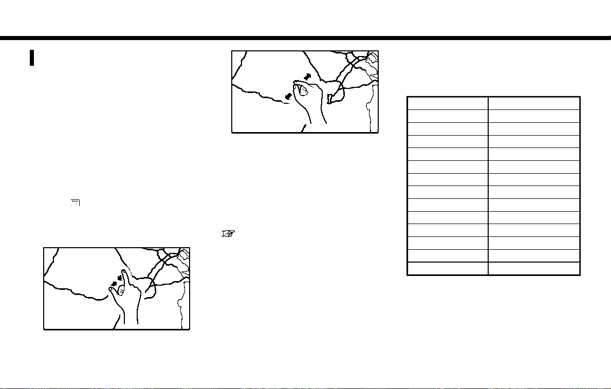
. Touch
Touch the screen. The cross pointer is
displayed at the center of the map. Touching
the screen again will scroll the map toward
the touched location.
. Long touch
Touch the direction to move to. The map
continues to scroll while the screen is
touched.
While driving, one-touch continuous scrolling is disabled.
. Drag
Drags the map while the screen is touched.
. Swipe
Swipe to scroll the map.
Multi-function controller operation:
Push and hold the main directional buttons and
the additional directional buttons to scroll the
map in the corresponding direction. The cross
pointer is displayed at the center of the map.
3. Map operation
MOVING MAP
The operations for moving across the map are
different between the 2D and Birdview
Map scrolling operations are limited and not fully
available while driving. When detailed map
screen is displayed while driving, the map cannot
be scrolled.
TM
maps.
2D MAP
BirdviewTM(3D) MAP
The following touch panel operations are available to move map.
. Touch
Touch the screen. The cross pointer is
displayed at the center of the map. Touching
the screen again will scroll the map toward
the touched location.
Touch [
the map.
. Long touch
Touch the direction to move to. The map
continues to scroll while the screen is
touched.
While driving, one-touch continuous scrolling is disabled.
. Drag
Drags the map while the screen is touched.
. Swipe
Swipe the touch panel to scroll the map
screen quickly.
]or[ ] to change the direction of
Multi-function controller operation:
Push and hold the left and right main directional
buttons to rotate the map counterclockwise or
clockwise.
Push and hold the rest of the main directional
buttons or additional directional buttons to scroll
the map in the corresponding direction. The
cross pointer is displayed at the center of the
map.
3-5
Page 30
3. Map operation
CHANGING SCALE OF MAP
There are several methods for changing the map
scale.
TOUCH PANEL OPERATION
Pinch-out
To view the map in detail, pinch-out the map
screen.
Free zoom:
Depending on the setting, using the center dial to
1. Touch .
The scale bar is displayed.
2. Touch [Zoom In] or [Zoom Out] to change
the scale.
change the map scale may adjust the scale
normally, or it may engage the free zoom (finer
scale adjustment in smaller steps).
“Settings screen” (page 7-24)
MULTI-FUNCTION CONTROLLER
OPERATION
Turn the center dial clockwise or counterclockwise to change the map scale.
Clockwise: Zoom in
Counterclockwise: Zoom out
Pinch-in
To view a wider area, pinch-in the map screen.
3-6
MAP SCALE
Any required map scale (map coverage) between 320 miles (640 km) and 1/32 mile (25 m)
can be selected.
US Units Metric Units
320 miles 640 km
80 miles 160 km
32 miles 64 km
8 miles 16 km
5 miles 10 km
2 miles 4 km
1 mile 2 km
1/2 mile 1 km
1/4 mile 500 m
1/8 mile 200 m
1/16 mile 100 m
1/32 mile 50 m
1/64 mile 25 m
Page 31

3. Map operation
INFO:
The traffic information icons are not displayed on
the map screen when the map scale is set to 8
miles (16 km) or higher.
“Traffic information on map” (page 7-6)
CHANGE MAP
The map view type can be changed by touching
[
]/[ ] on the map screen.
The screen will change to North Up, Heading Up
and Birdview
touched.
TM
each time [ ]/[ ]is
North Up
Heading Up
TM
Birdview
You can also set the map view by pushing
<SETTING> and touch [Navigation].
“Map view settings” (page 3-8)
3-7
Page 32

3. Map operation
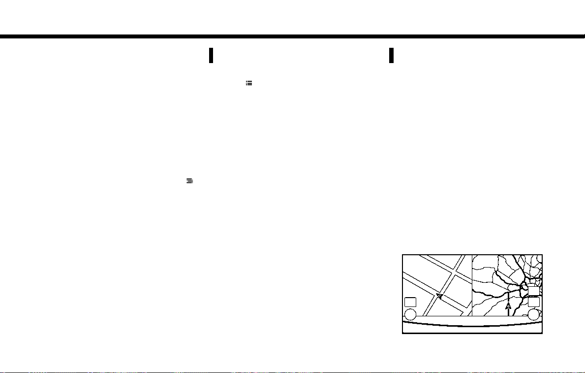
SETTING SPLIT SCREEN
It is possible to view the two types of map view or
the map view, and other information at the same
time. The right screen displays the map screen,
and the left screen displays a turn list or an
information screen.
1. Push <MAP> while the current location
map screen is displayed, the Display View
Bar is displayed.
2. Select the screen you would like to set.
“Display View Bar” (page 2-8)
MAP VIEW SETTINGS
The setup for the map view is performed from the
Settings menu.
1. Push <SETTING>.
2. Touch [Navigation].
The following settings are available.
3-8
Page 33

Menu item
Action
[Map & Display View] [Change Order] Sort the icon on the Display View Bar.
[Full Map] Display full map screen.
[Split Map] Select one of the settings to be applied to the display.
3. Map operation
[Intersection]
[Turn List]
[Where am I?]
[Turn by Turn]
[Fuel Economy]
[ECO Drive Report]
Menu item Action
[Map Preferences]
[Map View ] [North Up] Select one of the map views to be applied to the map screen.
[Heading Up]
[Birdview (3D)]
[Long Range Heading Up] The position of the vehicle icon can be changed to view a wider area in the
[Map Color] Select a preferred map color.
[Map Text Size] [Large] Sets the font size.
[Medium]
[Small]
“Display View Bar” (page 2-8)
traveling direction. The vehicle icon is located slightly lower than the center of the
screen.
Long Range Map View is available only when the map view is “Heading Up”.
3-9
Page 34

angle.
[Auto North Up] Sets the top of the map to remain oriented to the north.
[Show FWY Exit] Sets the display of the freeway exit information icon on/off.
[Automatic Display in Fwy Mode] The turn list can be set to on or off to be displayed automatically while driving on
a freeway.
[Names Displayed on Map] [Place Names] Allows place names to be displayed on the map screen.
[POI Names] Allows facilities names to be displayed on the map screen.
[Road Names] Allows road names to be displayed on the map screen.
[Left Split Map Settings] [Left Side Map Orientation] The map view for the left side of split screen can be selected from North Up or
Heading Up.
[Long-Range Driving Direction]
Allows the map view for the left side of the split screen to change the position of
the vehicle icon so that a wider area in the traveling direction can be viewed. The
vehicle icon is located slightly lower than the center of the screen.
3. Map operation
Menu item Action
[Birdview Angle] Adjusts the Birdview
TM
3-10
Page 35

SETTING INFORMATION ON
MAP
Some information on the map can be displayed
or hidden.
DISPLAYING FACILITY ICONS
The facility icons can be displayed or hidden by
type.
1. Push <SETTING>.
2. Touch [Navigation].
3. Touch [POI Icons Displayed on Map].
4. Touch the preferred icon. The indicator of the
selected icon illuminates.
INFO:
. The map icons are not displayed on the
map screen when the map scale is set
to 1/4 mile (500 m) or higher in the 2D
and Birdview
. If brand icons are registered in the map data,
the brand they will be displayed on the map
instead of the general map icons listed.
Available setting icon
.
: Restaurant
TM
map.
.
: Gas Station
.
: Hotel
.
:ATM
.
: Rest Area
DISPLAYING MAP SCROLLING INFORMATION
Information about the location, on which the
center of the cross pointer is placed by scrolling
on the map, can be set to be displayed.
1. Push <SETTING>.
2. Touch [Navigation] and touch [Other Settings].
3. Touch [Map Scrolling Information].
4. Touch the preferred information item.
The following information items are available.
. [Stored Location Icon Info]
3. Map operation
. [Destination/Waypoint Icon Info]
. [Latitude/Longitude Info]
ROAD COLOR
The road types are differentiated by color.
Freeway: Red or light red (zoomed in)
Main road: Brown or dark yellow
Narrow street: Gray
Road with incomplete map data: Dark green
3-11
Page 36

3. Map operation
TRAFFIC INFORMATION ON
MAP
With a subscription to the SiriusXM Traffic, traffic
information is displayed.
“Traffic information on map” (page 7-6)
Free Flow: Green arrow
Moderate traffic: Yellow arrow
Heavy traffic: Red
Section affected by serious traffic event: Purple
The following traffic information icons may be
displayed
: Accident
: Closed road
: Information
: Road work
: Slippery road
: Weather
: Incident
3-12
Page 37

4 Setting destination
Changing region ........................................................................ 4-2
Specifying state/province .................................................. 4-2
Specifying city ...................................................................... 4-2
Destination screen .................................................................... 4-3
Finding address ......................................................................... 4-7
Finding points of interest ......................................................... 4-8
Searching by a landmark name ........................................ 4-8
Searching from the landmark category .......................... 4-9
Setting home as destination ................................................ 4-10
Finding nearby place ............................................................. 4-11
Searching from Stored Locations ...................................... 4-11
Searching from history .......................................................... 4-12
Using Journey Planner .......................................................... 4-12
Setting intersection ................................................................ 4-13
Setting freeway entrance/exit ............................................. 4-14
Setting city center ................................................................. 4-14
Setting by phone number .................................................... 4-15
Setting from stored routes .................................................. 4-15
Searching by connecting Data Center ............................. 4-16
Setting by NissanConnect
Services ............................ 4-17
Searching by using IVR soft button on map ........... 4-17
Using Google send-to-car ........................................... 4-17
Using Destination Send to Car ................................... 4-17
Setting point on map ............................................................ 4-18
Procedures after setting route ........................................... 4-18
Moving location of destination .................................... 4-19
SM
Page 38

4. Setting destination
CHANGING REGION
When setting a destination, the location can be
narrowed down by specifying the region or city.
SPECIFYING STATE/PROVINCE
The state to be searched will be changed when
searching for a destination by entering an
address: [Street Address], [Points of Interest]
or [Intersection], etc.
INFO:
. It is not possible to search for a route from
the continental United States to Hawaii.
. When the system is restarted, it sets the
state to that automatically detected by the
GPS.
. When display State/Province input screen,
touch [Country] to change the country.
SPECIFYING CITY
When searching for a destination, the search can
be narrowed down by specifying the city.
1. Push <NAVI>.
2. Touch [Destination Menu].
3. Touch the key of the desired search method
to be set.
4. Touch [State/Province:].
5. Enter the name of the state and then touch
[List]. A list screen is displayed.
6. Touch the preferred region from the list. After
setting, the display automatically returns to
the Destination screen.
1. Touch [City]. A character input screen is
displayed.
2. Enter the name of the city and then touch
[List]. A list screen is displayed.
4-2
INFO:
. The same screen will be displayed when a
location is searched from a street.
. Touch [Last 5 Cities] to display the last
five cities set as destinations.
. Touch [All Cities] to display the all cities in
the current state/province.
3. Touch the city of the destination from the list.
INFO:
The number of matches are displayed to the left
of the entry results. In some cases, the number of
matches displayed on the screen and in the list
may differ. If this occurs, enter more characters
to further reduce the number of matches.
Page 39

4. Setting destination
DESTINATION SCREEN
There are several methods that can be used to set a destination. Understand the advantages of each method and select the best method for finding and
setting a preferred destination.
Step Setting item Action
Push <NAVI>. [Street Address] Searches for a destination by address.
[Points of Interest] Searches for a destination from various categories of businesses or
[Home] Searches for a route from the current location to the previously stored
[Destination Menu] [Street Address] Searches for a destination by address.
[Points of Interest] Searches for a destination from various categories of businesses or
“Finding address” (page 4-7)
locations.
“Finding points of interest” (page 4-8)
home destination.
“Setting home as destination” (page 4-10)
“Finding address” (page 4-7)
locations.
“Finding points of interest” (page 4-8)
4-3
Page 40

4. Setting destination
Step Setting item Action
[Home] Searches for a route from the current location to the previously stored
[Nearby Places] Searches for points of interest near the current vehicle location, such
[Stored Locations] Searches for a destination from the list of the stored locations.
[Previous Destinations] Sets the previous starting point as the destination. Searches for the
[Journey Planner] Sets a route plan downloaded from the NISSAN Owner’s Portal
[Intersection] Searches for a destination from an intersection.
[Freeway Entrance/Exit] Searches for a destination from a freeway entrance/exit.
[City Center] Sets the center of a city as the destination.
[Phone Numbers] Searches for a point of interest by a telephone number.
[Stored Routes] Selects a stored route.
[Connected Search] Input a keyword of a point of interest and connect and search the
4-4
home destination.
“Setting home as destination” (page 4-10)
as restaurants and charging stations, etc.
“Finding nearby place” (page 4-11)
“Searching from Stored Locations” (page 4-11)
destination from the previous destinations.
“Searching from history” (page 4-12)
Website.
“Using Journey Planner” (page 4-12)
“Setting intersection” (page 4-13)
“Setting freeway entrance/exit” (page 4-14)
“Setting city center” (page 4-14)
“Setting by phone number” (page 4-15)
“Setting from stored routes” (page 4-15)
NissanConnect
“Searching by connecting Data Center” (page 4-16)
SM
Services Data Center.
Page 41

Step Setting item Action
Scroll map and touch [
Push <INFO>. [NissanConnect Ser-
]. [New Destination] Set a location scrolled to on the map as the destination
[Connect to Voice Menu] Connects to the NissanConnect
vices]
[Sync All Feeds] Updates information list by connecting to the NissanConnect
Services Data Center.
[Connected Search] Input a keyword of a point of interest and connect and search the
NissanConnect
[Send to Car] Search for a location using Google maps, and download the
information to set the destination via the NissanConnect
Data Center.
[Destination Send to Car] Search for destinations from a point of interest (POI) database
accessed within the NissanConnect
[Journey Planner] Sets a route plan downloaded from the NISSAN Owner’s Portal
Website.
[History] The information feeds that were previously referred to are displayed.
4. Setting destination
SM
Services Interactive Voice Menu.
SM
“Searching by connecting Data Center” (page 4-16)
“Using Google send-to-car” (page 4-17)
“Using Destination Send to Car” (page 4-17)
“Using Journey Planner” (page 4-12)
Services Data Center.
SM
portal website.
SM
SM
Services
Push IVR soft button.
Speak your choice, or ask the NissanConnect
search for your destination.
SM
Services Response Specialists directly to
Set the destination with the assistance of a NissanConnect
Services Response Specialist.
SM
4-5
Page 42

4. Setting destination
INFO:
. If the route is already set, the selected location becomes a waypoint.
. After setting a destination, the location of the destination can be adjusted and the location can be stored in the Address Book, etc.
. The destination can be deleted.
“Procedures after setting route” (page 4-18)
“Canceling Route” (page 5-7)
4-6
Page 43

4. Setting destination
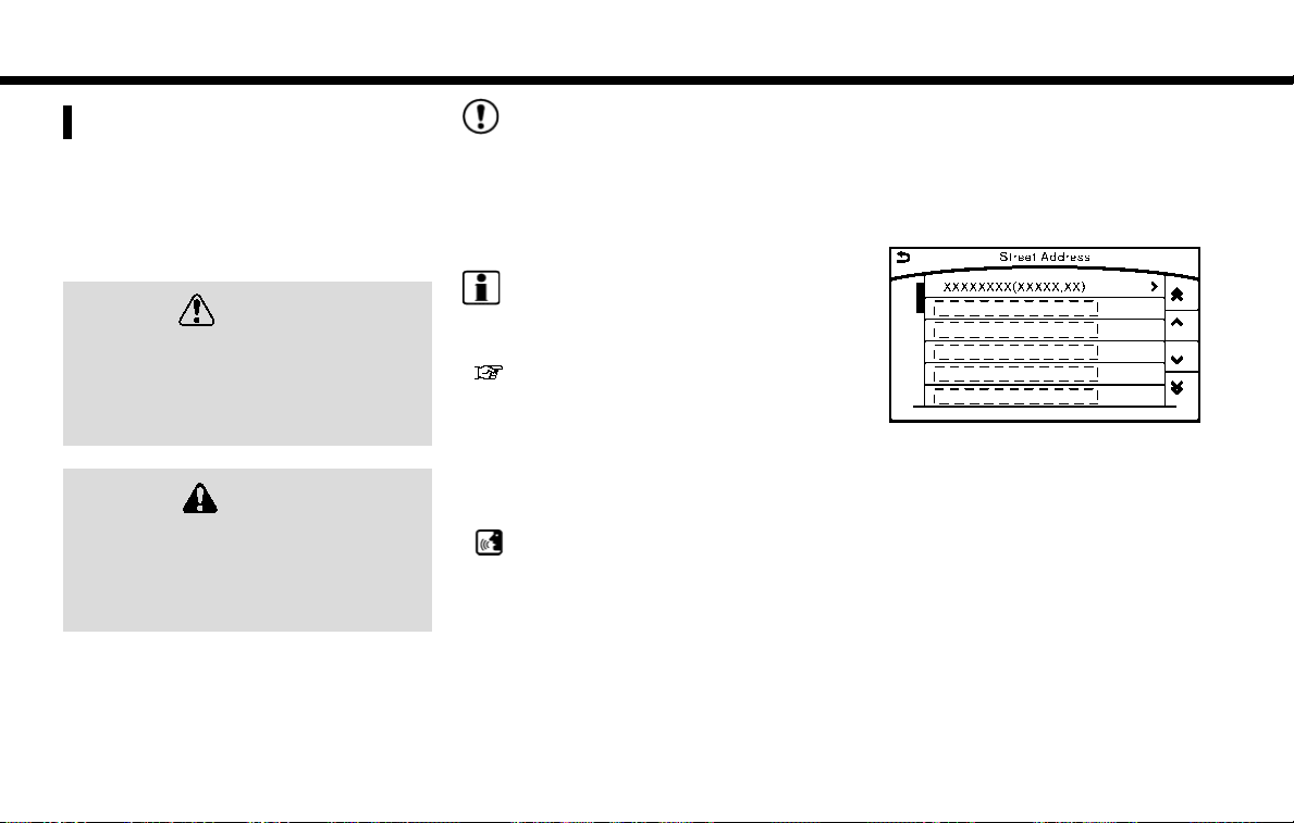
FINDING ADDRESS
Searches for a destination by address.
1. Push <NAVI>.
2. Touch [Street Address]. A number input
screen is displayed.
3. Input the street address.
. When [City] is selected , a city can be
specified by typing the city name.
. When [City Center] is touched while a city
is selected, the center of the city
becomes the target of the search.
. Touch [Intersection] to enter the intersec-
tion.
. If the house number is not available, touch
[No House #].
4. When information about house number,
street, city, and state are entered, the
destination is proposed on the display.
Touch [OK].
INFO:
. Touch [State/Province:] or [City] to nar-
row down the specified region and city.
“Changing region” (page 4-2)
5. Enter the name of the street. After finishing
the entry, touch [List]. A list of streets is
displayed.
6. Touch the street of the destination from the
list.
INFO:
Touch [
] to return to the previous screen.
7. Touch [Start] to start route guidance.
INFO:
. The [Street Address] can also be set by
pushing <NAVI> and then touching
[Destination Menu].
. After setting a destination, the location of
the destination can be adjusted and the
location can be stored in the Address
Book, etc.
“Procedures after setting route”
(page 4-18)
Voice command
1. Push <
> located on the steering-wheel.
2. After the tone sounds, speak a command.
To searches for a destination by address:
“Navigation”, "Street Address”
4-7
Page 44

4. Setting destination
FINDING POINTS OF INTEREST
This allows you to find a facility by name or by
category. Specify the region and city of the
destination to find it more quickly.
NOTE:
Locations and business hours of facilities
are subject to change, which may not be
reflected in the map data. Double-check
this information before you go to an
emergency facility to ensure that you can
receive the proper support. Otherwise, you
may not receive emergency help when you
arrive at the destination.
A confirmation message also appears on
the navigation screen. Follow the displayed
instructions and check the items required.
SEARCHING BY A LANDMARK
NAME
1. Push <NAVI>.
2. Touch [Points of Interest].
3. Touch [Spell Name]. A character input
screen is displayed.
INFO:
Touch [City] and touch [Last 5 Cities] to
display the last five cities recently set as
destinations.
4. Enter the name of the destination facility.
After finishing the entry, touch [List]. A list
screen is displayed.
5. Touch the preferred destination facility from
the list.
Narrow down conditions:
. [Sort]:
— [By Distance]:
Shows a list of facilities that are near the
current vehicle location.
— [By Name]:
Shows a list of facilities sorted alphabetically by name order.
. [By Category]:
Display the list that summarizes the
entered names into categories. Select
the category to narrow down the search.
Touch [Show Related] to display the
related facility on the narrowed down
category list.
. [City/Area]:
— [Within a City]:
Input the city to narrow down the target
city.
— [Near Destination]:
When the destination is set, this indicates
a list of facilities around the destination.
— [Show Along Route]:
The system displays the facilities located
along the route.
4-8
Page 45

4. Setting destination
INFO:
. Touch [ ] in the list screen to display
the detailed information about the POI
that is selected. Touch [Call] to make a
call to the facility.
6. Whole route map is displayed. Touch [Start]
to start route guidance.
INFO:
. The [Points of Interest] can also be set by
pushing <NAVI> and then touching [Destination Menu].
. If [Space] is touched and a keyword is
inputted, a search will be possible after
entering two or more words.
. After setting a destination, the location of the
destination can be adjusted and the location
can be stored in the Stored Locations, etc.
“Procedures after setting route”
(page 4-18)
SEARCHING FROM THE LANDMARK
CATEGORY
1. Push <NAVI>.
2. Touch [Points of Interest]. The main category
menu is displayed.
3. Touch the main category. The subcategory
list is displayed.
4. Touch the subcategory. A list screen is
displayed.
Narrow down conditions:
. [Sort]:
— [By Distance]:
Shows a list of facilities that are near the
current vehicle location.
— [By Name]:
Shows a list of facilities sorted alphabetically by name order.
. [Spell Name]:
Enter the facilities name to narrow down
the search.
. [City/Area]:
— [Within a City]:
Input the city to narrow down the target
city.
— [Near Destination]:
When the destination is set, this indicates
a list of facilities around the destination.
— [Show Along Route]:
The system displays the facilities located
along the route.
5. Touch the preferred destination facility from
the list.
Touch [Start] to start route guidance.
INFO:
. After setting a destination, the location of the
destination can be adjusted.
“Procedures after setting route”
(page 4-18)
. If the nearest POI cannot be searched, a
message asking whether to search from an
extended area will be displayed. When [Yes]
is selected, the system starts to search for
4-9
Page 46

4. Setting destination
POI in a wider area.
SETTING HOME AS DESTINATION
The home location can be set as the destination
if the home location is stored in advance. This
function is especially useful when searching for a
route to return to the home location.
1. Push <NAVI>.
2. Touch [Home].
3. The home location is displayed, and the
system sets the home location as the
destination.
INFO:
If the home location is not stored yet, the
system will automatically display a screen for
storing it.
“Storing home location” (page 6-2)
4. Touch [Start] to start route guidance.
INFO:
The [Home] can also be set by pushing <NAVI>
and then touching [Destination Menu].
Voice command
1. Push <
2. After the tone sounds, speak a command.
To set the home location as the destination:
“Home”
> located on the steering-wheel.
4-10
Page 47

4. Setting destination
FINDING NEARBY PLACE
A facility located near the current vehicle location
or another location that you move to by scrolling
the map can be set as the destination. This
allows you to set the destination to a facility
located near the current vehicle location or
another location that you move to by scrolling
the map.
1. Push <NAVI>.
2. Touch [Destination Menu].
3. Touch [Nearby Places]. The category list is
displayed.
4. Select [RESTAURANT] for example.
5. Select preferred category from the sub
category list.
6. Touch the preferred destination from the list.
The position of the selected location is
displayed in the preview.
INFO:
. If the suggested route is already set, by
touching [Show Along Route], the system
displays only the facilities located along
the route.
. A maximum of 100 facilities can be
displayed on the list screen.
7. Touch [Start] to start route guidance.
INFO:
You can also set the destination by touching
[
] when scrolling the map and selecting
[Nearby Places] from the shortcut menu.
SEARCHING FROM STORED
LOCATIONS
Storing frequently used destinations in the
Address Book makes it easy to set a destination.
Locations should be stored in the Address Book
before using this function.
“Storing location” (page 6-2)
1. Push <NAVI>.
2. Touch [Destination Menu].
3. Touch [Stored Locations].
4. Touch the preferred location from the list.
INFO:
. Selecting [Sort] displays a list of various
sort functions.
— [By Number]:
The Address Book entries are displayed
in ascending numerical order.
4-11
Page 48

4. Setting destination
— [By Name]:
The Address Book entries are displayed
in alphabetic order.
— [By Icon]:
By selecting a particular icon, a list that
contains only the Address Book entries
associated with that icon is displayed.
— [By Group]:
By selecting a particular group (family,
friends, leisure, etc.), the selected group
is displayed at the top of the list.
. When [Store] is touched, a new location
can be stored.
5. Touch [Start] to start route guidance.
Voice command
1. Push <
2. After the tone sounds, speak a command.
To set the destination from the Stored Locations:
“ Stored Locations”
> located on the steering-wheel.
SEARCHING FROM HISTORY
A previous destination can be set as the
destination.
Up to 100 previous destinations will be
automatically stored. If the number of previous
destinations exceeds 100, the oldest one will be
replaced by the newest one.
1. Push <NAVI>.
2. Touch [Destination Menu].
3. Touch [Previous Destinations]. A list screen
is displayed.
4. Touch the previous start point or the previous
destination from the list.
5. Touch [Start] to start route guidance.
Voice command
1. Push <
2. After the tone sounds, speak a command.
To display the previous destinations list:
“Previous Destinations”
> located on the steering-wheel.
USING JOURNEY PLANNER
It is possible to set the route according to the
route plan created in advance by the NISSAN
Owner’s Portal Website.
INFO:
SM
Use of NissanConnect
dependent upon a valid subscription and the
telematics device being in operative condition, as
well as cellular connectivity, navigation map data
and GPS satellite signal reception being available.
1. Push <NAVI>.
2. Touch [Destination Menu].
3. Touch [Journey Planner]. The system will
connect to the NissanConnect
Data Center and display the Journey Planner
list screen.
Services features is
SM
Services
4-12
Page 49

4. Setting destination
4. Select the preferred route plan from the list.
INFO:
. Touch [Update List] to update the list
information.
. Touch [Details] to preview the route.
. Touch to display facility information.
5. The selected route plan is displayed. Touch
[Start] after confirming the location of the
displayed destination.
INFO:
. The Journey Planner can also be set by
pushing <INFO> and then touching [NissanConnect Services].
. Journey Planner is a NissanConnect
Services feature. Subscription is required
to use the NissanConnect
SM
Services.
SM
. Journey Planner cannot be used if [Decline]
is touched on the Start-up Screen.
. Refer to the NISSAN Owner’s Portal Web-
site for how to set the destination using
Journey Planner.
SETTING INTERSECTION
It is possible to set an intersection of any two
streets as the destination and have the system
calculate a route.
1. Push <NAVI>.
2. Touch [Destination Menu] and touch [Intersection].
3. The first street input screen is displayed.
INFO:
Touch [State/Province], [Country] or [City] to
narrow down the specified country and city.
4. Enter the name of the first street. After
finishing the entry, touch [List]. A list screen
is displayed.
INFO:
If the country or city is changed after
selecting the first street, the first street that
was selected will be canceled.
5. Touch a street as the first street from the list.
6. The second street input screen is displayed.
7. Enter the name of the second street. After
finishing the entry, touch [List]. A list screen
is displayed.
INFO:
Touch [Map] on the list to preview the
location of the selected junction.
8. Touch a street as the second street from the
list.
9. Whole route map is displayed. Touch [Start]
to start route guidance.
4-13
Page 50

4. Setting destination
SETTING FREEWAY ENTRANCE/
EXIT
It is possible to set the destination to an entrance
or exit of a freeway.
1. Push <NAVI>.
2. Touch [Destination Menu].
3. Touch [Freeway Entrance/Exit]. A character
input screen is displayed.
4. Enter the name of the freeway. After finishing
entry, touch [List].
5. Touch the preferred freeway.
6. Touch [Entrance] /[Exit]. A list screen is
displayed.
7. Touch the preferred destination from the list.
The selected location is displayed in the
preview.
INFO:
Touch [Sort] and touch [By Distance] to sort
the list by the nearest distance. Touch [By
Road No.] to sort by the road no.
8. Touch [Start] to start route guidance.
SETTING CITY CENTER
It is possible to set the center of a specified city
as a destination.
1. Push <NAVI>.
2. Touch [Destination Menu].
3. Touch [City Center]. A character input
screen is displayed.
4. Enter the name of the city and touch [List]. A
list screen is displayed.
INFO:
Touch [Last 5 Cities] to display the last five
cities recently set as destinations.
5. Touch the preferred destination from the list.
INFO:
Touch [Map] to preview on the display.
6. The selected destination is displayed. Touch
[Start] after confirming the location of the
displayed destination.
4-14
Page 51

4. Setting destination
SETTING BY PHONE NUMBER
If the phone number of a facility is known, it is
possible to search for a facility by entering the
phone number.
INFO:
. If the area code of the specified telephone
number does not exist in the map data, the
system cannot search for the location.
. Only the locations included in the database
in the map data can be searched for by
phone number. Residential phone numbers
cannot be used to search for a location.
1. Push <NAVI>.
2. Touch [Destination Menu].
3. Touch [Phone Numbers]. The telephone
number input screen is displayed.
4. Enter the telephone number including the
area code. After finishing entry, touch [OK].
INFO:
A list screen is displayed if there are two or
more search results. Touch the preferred
destination from the list.
5. The selected destination is displayed. Touch
[Start] after confirming the location of the
displayed destination.
SETTING FROM STORED
ROUTES
It is possible to select a preferred route from the
stored routes.
1. Push <NAVI>.
2. Touch [Destination Menu].
3. Touch [Stored Routes]. A list screen is
displayed.
4. Touch the preferred route from the list.
5. The stored route is displayed, touch [New
Dest.].
6. The entire route is shown on the map. Touch
[Start] to start route guidance.
4-15
Page 52

4. Setting destination
INFO:
. The stored route only includes locations
(destination and waypoints) and route calculation conditions, not the route itself.
Therefore, when the destination is set using
a stored route, a different route may be
suggested if the current vehicle location is
different from the one when the route was
stored.
SEARCHING BY CONNECTING
DATA CENTER
It is possible to find a point of interest by
inputting a keyword and connecting to the
NissanConnect
searched location can be set as a destination.
INFO:
Use of NissanConnect
dependent upon a valid subscription and the
telematics device being in operative condition, as
well as cellular connectivity, navigation map data
and GPS satellite signal reception being available.
1. Push <NAVI>.
2. Touch [Destination Menu].
3. Touch [Connected Search].
4. Enter the keyword and touch [Search]. The
system will connect to the NissanConnect
Services Data Center and the search results
will be displayed.
5. Touch the preferred destination from the list.
SM
Services Data Center. The
SM
Services features is
SM
INFO:
. Touch [info] to display the facility informa-
tion.
. Touch [Details] to display the information
feeds screen.
“Screen information” (page 7-20)
6. The entire destination is shown. Touch [Start]
to start route guidance.
INFO:
The Connected Search can also be set by
pushing <INFO> and then touching [NissanConnect Services].
4-16
Page 53

4. Setting destination
SETTING BY NISSANCON-
SM
NECT
It is possible to set the destination using the
NissanConnect
SERVICES
SM
Services features.
“NissanConnectSMServices” (page 7-14)
INFO:
SM
Use of NissanConnect
Services features is
dependent upon a valid subscription and the
telematics device being in operative condition, as
well as cellular connectivity, navigation map data
and GPS satellite signal reception being available.
SEARCHING BY USING IVR SOFT
BUTTON ON MAP
It is possible to set a destination by touching the
IVR (Interactive Voice Response) soft button
on the map. You can choose from the options
provided by the voice guidance and speak your
*
choice, or ask the NissanConnect
Response Specialists directly to search for your
destination.
“Connecting to Interactive Voice Menu”
(page 7-18)
USING GOOGLE SEND-TO-CAR
It is possible to search for a location using
Google maps, and to download the information
to set the destination via the NissanConnect
Services Data Center.
1. Push <INFO>.
2. Touch [NissanConnect Services].
3. Touch [Send to Car].
The system connects to the NissanCon-
SM
nect
destination list is downloaded.
4. Select the preferred destinations from the
1
list. The position of the selected location is
displayed in the preview.
Services Data Center and the
SM
Services
SM
INFO:
Select [Update List] to update the list
information.
5. Touch [Start] to start route guidance.
INFO:
Refer to the NISSAN Owner’s Portal Website for
the destination setting using Google send to car.
USING DESTINATION SEND TO CAR
Destination Send to Car enables you to search
for destinations from a point of interest (POI)
database accessed within the NissanConnect
SM
portal website.
1. Push <INFO>.
2. Touch [NissanConnect Services].
3. Touch [Destination Send to Car].
4. Select preferred folder.
5. Select preferred channel. The list of destinations which you set at the NissanConnect
SM
portal website is displayed.
6. Select preferred destination from the list.
4-17
Page 54

4. Setting destination
INFO:
Select [Update List] to update the list of point of
interest.
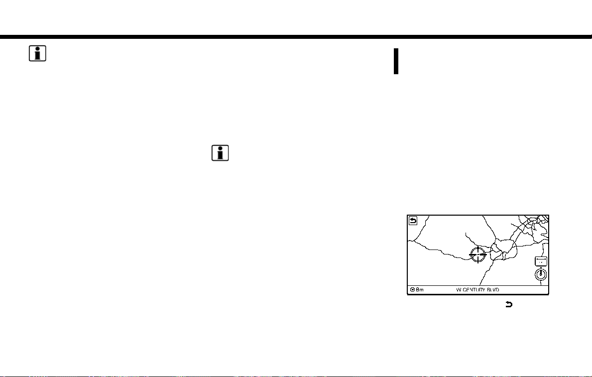
SETTING POINT ON MAP
It is possible to set a location scrolled to on the
map as the destination and have the system
calculate a route.
1. Scroll the map, place the cross pointer over
the preferred location, and touch [
INFO:
. The point on the blinking road where the
center of the cross pointer is located can
be set as a destination.
2. Touch [New Destination].
3. The entire route is shown. Touch [Start] to
start route guidance.
].
PROCEDURES AFTER SETTING
ROUTE
The system sets the destination to the selected
location and starts calculating a route. After
performing a route search, route guidance can
be started. Also, it is possible to confirm or
change a route.
Available items after setting route
. [Start]:
Starts route guidance to the selected destination.
INFO:
If no operations have been performed on the
system for several seconds, [Start] is automatically selected, and the system starts route
guidance. When the vehicle is being driven,
[Start] is automatically selected and the system
4-18
Page 55

4. Setting destination
will start the route guidance function.
. [More Routes]:
Route conditions for route calculation can be
changed.
The routes may not always be different.
— [Fastest Route] :
Prioritizes the shortest time.
— [Energy-Saving] :
Energy-Saving route.
— [Shortest Distance] :
Prioritizes the shortest distance.
. [Turn List]:
Display the turn list.
. [Add Waypoint]:
Allows you to edit the route by adding a
destination or waypoint.
— If a waypoint is added, three alternative
routes cannot be selected.
— If a destination is added, the prior
destination becomes a waypoint.
— It is possible to edit or add a destination or
waypoints to the route that is already set.
“Editing route” (page 5-8)
. [Move Loc.]
The location of the destination or waypoint
can be adjusted by moving the cross pointer
across the map.
“Moving location of destination”
(page 4-19)
. [Information]:
Allows you to store the destination. If there is
information about the destination (street
address and phone number) stored in the
map data, it can also be displayed.
MOVING LOCATION OF DESTINATION
The location of the destination can be adjusted
by moving the cross pointer across the map.
1. After setting destination, touch [Move Loc.].
2. Touch map screen. A map screen with the
destination located on the map center is
displayed.
3. Adjust the location by moving the cross
pointer across the map and touch [OK]. The
location of the destination is modified.
INFO:
. The screen for adjusting the location also
changes when the map screen displayed on
the right side of the screen is touched.
. The map scale can be changed.
“Changing scale of map” (page 3-6)
4-19
Page 56

4. Setting destination
MEMO
4-20
Page 57

5 Route guidance
About route guidance .............................................................. 5-2
Voice guidance during route guidance .......................... 5-2
Route guidance screens .................................................... 5-4
Guidance screen settings ....................................................... 5-7
Canceling Route ........................................................................ 5-7
Route menu screen .................................................................. 5-7
Editing route ............................................................................... 5-8
Setting destination or waypoint ....................................... 5-9
Editing/deleting destination or waypoint ....................... 5-9
Changing route calculation conditions ....................... 5-10
Changing order of destination and waypoints ........ 5-10
Recalculating route ............................................................... 5-11
Searching for detour route using traffic information ..... 5-11
Traffic information based detour ................................. 5-11
Specified distance based detour ............................... 5-12
Automatic detour guidance ......................................... 5-12
Displaying Turn List ............................................................... 5-13
Route guidance settings ...................................................... 5-13
Guidance settings .......................................................... 5-14
Route Settings ................................................................ 5-16
Page 58

5. Route guidance
ABOUT ROUTE GUIDANCE
After setting the route, select [Start] to start route
guidance.
Throughout route guidance, the system navigates you through the guide points using visual
and voice guidance.
CAUTION
. The navigation system’s visual and
voice guidance is for reference purposes only. The contents of the
guidance may be inappropriate depending on the situation.
. Follow all traffic regulations when
driving along the suggested route
(e.g., one-way traffic).
“Route guidance” (page 9-8)
VOICE GUIDANCE DURING ROUTE
GUIDANCE
Basics of voice guidance
Voice guidance announces which direction to
turn when approaching an intersection for which
a turn is necessary.
Example of voice guidance
1
“In about one quarter mile (400 meters),
*
right (left) turn.”
“Right (left) turn ahead.”
5-2
2
“In about one quarter mile (400 meters)
*
freeway entrance on your right onto (road
number and direction).”
“Freeway entrance on your right onto (road
Page 59

INFO:
. Distances may vary, depending on the
vehicle speed.
. There may be some cases in which voice
guidance and actual road conditions do not
correspond. This may occur because of
discrepancies between the actual road and
the information on the map data, or may also
be due to the vehicle’s speed.
. In case voice guidance does not correspond
to the actual road conditions, follow the
information obtained from traffic signs or
notices on the road.
. Route guidance provided by the navigation
system does not take carpool lane driving
into consideration, especially when carpool
lanes are separated from other road lanes.
. The system will only announce street names
when the system language is set to English.
Street names are not announced when the
system is set to French or Spanish.
. When approaching a guide point (intersec-
tion or corner), destination, etc. during route
guidance, voice guidance announces the
remaining distance and/or turning direction.
5. Route guidance
number and direction).”
3
“In about one mile (two kilometers), exit on
*
your right.”
“Exit on your right.”
4
“You have arrived at your destination. End-
*
ing route guidance.”
Directions will differ, depending on the road type.
Repeating voice guidance
This function is available throughout route
guidance, from the time after the route calculation is completed until the vehicle arrives at the
destination. Push <VOICE>. Voice guidance
will be repeated.
INFO:
. If <VOICE> is pushed when the vehicle is
deviating from the suggested route and
when the automatic reroute function is off,
voice guidance will announce, “Proceed to
the highlighted route.”
. If <VOICE> is pushed when the vehicle is
going in the wrong direction, the system will
announce a route to allow you to resume the
route set with voice guidance.
Notification when approaching destination
Ordinary road:
When approaching the destination, voice gui-
dance will announce, “You have arrived at your
destination. Ending route guidance.” To reach
your final destination, refer to the map screen.
Dark green road:
After passing the last turning point on a
suggested route, voice guidance will announce,
“The route to your destination includes roads
through incomplete map areas. Voice guidance
will not be provided in these areas.” When
approaching the endpoint of the suggested road,
voice guidance will announce, “Entering the road
with incomplete map data. Please use the
direction arrow and distance information to
proceed to your destination.”
Notes on voice guidance
. Voice guidance in this system should be
regarded as a supplementary function.
When driving the vehicle, check the route
on the map and follow the actual roads and
traffic regulations.
. Voice guidance is activated only for inter-
sections with certain conditions. There may
be cases where the vehicle has to turn, but
5-3
Page 60

“Volume settings” (page 7-28)
. Voice guidance will start when the vehicle
enters the suggested route. Refer to the map
for directions to the starting point of the
route.
. When approaching a waypoint, voice gui-
dance will announce, “You have arrived at
waypoint 1 (2, 3, 4,...).” Voice guidance will
switch to the next section of the route. When
voice guidance is not available, refer to the
map for directions.
. In some cases, voice guidance ends before
arrival at the destination. Refer to the
destination icon on the map to reach the
destination.
. If the system recognizes on which side the
destination (waypoint) is located, voice
guidance will announce “on the right/left”
after announcing the arrival at the destination.
. Voice guidance may be partially operational
or inoperative due to the angle of roads at an
intersection.
. Because freeway lane information is avail-
able only for approximately 7,000 major
freeways in North America, it is not possible
to display information for all junctions and
exits.
. Freeway exit information may differ from the
information on the actual exit signs.
. Because it is not possible to consider data
concerning roads that are seasonally avail-
able or unavailable, a route may be displayed
that does not match the actual traffic
restrictions. Be sure to follow the actual
traffic restrictions while driving.
. Canada and Alaska contain many roads with
incomplete map data. As a result, when
searching for a route, the route may include
roads with incomplete data. In regions where
road data is not complete, voice guidance
may stop for long periods of time. Be sure to
follow the actual traffic restrictions while
driving.
5. Route guidance
voice guidance is not provided.
. Voice guidance contents may vary, depend-
ing on the direction of the turn and the type of
intersection.
. The voice guidance timing will vary depend-
ing on the situation.
. When the vehicle has deviated from the
suggested route, voice guidance is not
available. The system will not announce this.
Refer to the map and recalculate the route.
“Recalculating route” (page 5-11)
. Voice guidance may not accurately corre-
spond with road numbers and directions at
freeway junctions.
. Voice guidance may not accurately corre-
spond to street names at freeway exits.
. The displayed street names may sometimes
differ from the actual names, or “UNKNOWN
STREET NAME” may be displayed.
. Voice guidance is not available when the
[Voice Guidance] is turned off.
5-4
ROUTE GUIDANCE SCREENS
Various guidance screens are displayed during
route guidance.
Page 61

5. Route guidance
Route guidance on map screen
When route guidance starts, the small turn arrow
on map is displayed in the upper left corner of the
map screen. This arrow indicates the turning
direction at the next guide point (corner or
intersection). The distance is also displayed. At
the top of the screen, the distance to the next
guide point and the name of the next street to
turn on to are displayed. Also, there may be
cases where next street names are announced.
Enlarged intersection view
When approaching a guide point, the system
automatically changes to the split screen and
shows an enlarged view of the intersection on
the left screen. To switch to the previous screen
while the enlarged intersection view is displayed,
push <MAP>.
Depending on the setting, the system can
constantly display the split screen as the display
view screen.
Junction guidance
While driving on a freeway, when the vehicle is
approximately one mile (approximately two km)
from a junction, the system automatically
switches to the split screen and displays an
enlarged view of the junction on the left screen.
After passing the junction, the system automatically returns to the full screen mode. To switch
to the previous screen while the enlarged
junction view is displayed, push <MAP>.
5-5
Page 62

5. Route guidance
Turn list
When approaching a guide point, the left screen
automatically switches to an enlarged view of the
intersection. To switch to the previous screen
push <MAP>.
Depending on the setting, the system can
constantly display the split screen as the display
view screen.
Showing freeway exit information
When [Show FWY Exit] is set to ON and the
route includes a freeway or toll road, all exits
along the route which have exit information will
be shown in the turn list. The exit information is
shown as icons.
Selecting a waypoint from the exit
information list
When exit information is displayed on the turn
list, a waypoint to a facility located near the
freeway exit can be set as a waypoint. The facility
categories that are not shown with an icon
cannot be selected.
1. Touch the exit where the exit information icon
is displayed. The category list screen is
displayed.
2. Touch the landmark category. The list screen
for showing facilities located near the freeway exit is displayed.
INFO:
The facility categories that are not shown
with an icon cannot be selected.
3. Touch the preferred facility for the waypoint.
4. The waypoint is set, and the route search is
performed.
“Procedures after setting route”
(page 4-18)
5-6
Page 63

5. Route guidance
GUIDANCE SCREEN SETTINGS
The guidance screen can be displayed at all
times even when the vehicle is located away from
the guide point. Various types of screens can be
set.
“Display View Bar” (page 2-8)
CANCELING ROUTE
It is possible to delete a destination and all
waypoints that have already been set.
1. Push <NAVI>.
2. Touch [Cancel Route].
3. A confirmation message is displayed.
The destination and the waypoints are
deleted.
INFO:
. The [Cancel Route] can also be set by
pushing <NAVI> and then touching [Route
Menu].
. The deleted destination and waypoints
cannot be reactivated.
ROUTE MENU SCREEN
WARNING
Always stop the vehicle in a safe location
before modifying the route conditions.
Modifying the route conditions while
driving may cause an accident.
During route guidance, the route conditions can
be modified and the route information can be
confirmed. Set route conditions according to
your personal preference.
Route menu screen display only when a
destination is already set.
1. Push <NAVI>.
2. Touch [Route Menu].
3. The following items are available.
5-7
Page 64

5. Route guidance
Available settings
. [Edit Route]:
Edit or add a destination or waypoint to the
route that is already set.
“Editing route” (page 5-8)
. [Search Criteria Settings]:
Change the route calculation conditions
anywhere along the route.
“Route Settings” (page 5-16)
. [Recalculate]
Manually search for the route again after
changing the search conditions and have the
system calculate a route.
“Recalculating route” (page 5-11)
. [Show Destination]:
The destination is displayed on the map
screen.
. [Detour]:
A detour of a specified distance can be
calculated.
“Specified distance based detour”
(page 5-12)
. [Cancel Route]:
The destination and the waypoints on the
route are deleted.
. [Turn List]:
Display the turn list.
“Displaying Turn List” (page 5-13)
INFO:
The [Cancel Route], [Turn List] and [Edit Route]
can be set only by pushing <NAVI>.
EDITING ROUTE
1. Push <NAVI>.
2. Touch [Edit Route].
3. Set the preferred conditions.
Available settings
1
[Add Destination]
*
Touch to add a destination.
“Setting destination or waypoint”
(page 5-9)
2
Current destination:
*
Changes or deletes the destination.
“Editing/deleting destination or waypoint” (page 5-9)
3
Condition for calculating a route to the
*
destination:
Changes the conditions for calculating a
route to the destination.
5-8
Page 65

5. Route guidance
“Changing route calculation conditions” (page 5-10)
4
[Add Waypoint]
*
*
*
*
*
5
6
7
8
“Setting destination or waypoint”
(page 5-9)
Current waypoint:
Changes or deletes the waypoint.
“Editing/deleting destination or way-
point” (page 5-9)
Condition for calculating a route to a
waypoint:
Changes the conditions for calculating a
route to a waypoint.
“Changing route calculation condi-
tions” (page 5-10)
[Sort]:
Sorts the waypoint and the destination.
[Store Route]:
Stores route include a destination, way-
points, and route condition. A maximum of
five routes can be stored. Stored routes can
be easily retrieved and set as the suggested
route.
INFO:
The [Edit Route] can also be set by pushing
<NAVI> and then touching [Route Menu].
SETTING DESTINATION OR WAYPOINT
A destination or waypoint can be added to a
route that has already been set. A total of six
destinations or waypoints can be set.
1. Push <NAVI>.
2. Touch [Edit Route].
3. Touch [Add Destination] or [Add Waypoint].
INFO:
If [Add Destination] is selected, the current
destination changes to a waypoint.
4. Set a destination or waypoint. The method of
searching for a destination or waypoint is the
same as the one for a destination.
“Destination screen” (page 4-3)
5. The system will recalculate the routes.
INFO:
The prior route is automatically deleted.
EDITING/DELETING DESTINATION
OR WAYPOINT
A destination or waypoint that has already been
set can be modified or deleted. If a location is
modified or deleted when a suggested route is
already set, the prior suggested route will be
recalculated accordingly.
1. Touch a destination or waypoint that is
already set.
2. Touch the item you would like to set.
Available settings
. [Move Loc.]:
The location of the destination or way-
5-9
Page 66

5. Route guidance
point can be adjusted by moving the
cross pointer across the map.
. [Delete]:
A destination or waypoint that has already
been set can be deleted.
INFO:
If the destination is deleted, the final waypoint of
the route becomes the destination.
CHANGING ROUTE CALCULATION
CONDITIONS
Each section of the route between waypoints
can have different route calculation conditions.
After setting these conditions, the entire route
can be recalculated.
1. Touch the preferred section of the route to
the destination or waypoint.
2. Touch the preferred condition.
3. The conditions are changed and the display
returns to the Edit Route screen.
INFO:
. The recalculated route may not be the
shortest route because the system prioritizes
roads that are easy to drive on for safety
reasons.
CHANGING ORDER OF DESTINATION AND WAYPOINTS
The order of a destination and waypoints that are
already set can be changed.
1. Touch [Sort]. A list of the destination and
waypoints is displayed.
2. When [
touching the icon, slide it to the place where
you would like to move it.
] is touched, a chime will sound. Still
3. Touch [
] to apply the change.
5-10
Page 67

5. Route guidance
RECALCULATING ROUTE
A route can be manually searched again after
changing the search conditions.
1. Push <NAVI>.
2. Touch [Route Menu].
3. Touch [Recalculate]. A message is displayed
and the route is recalculated.
INFO:
. When a waypoint has been set on the route,
the system will search for only one route,
even if route recalculation is performed.
. When the vehicle deviates from the sug-
gested route, the route from the current
location to the destination is automatically
searched again by the Auto Reroute function.
“Route Settings” (page 5-16)
SEARCHING FOR DETOUR
ROUTE USING TRAFFIC INFORMATION
There are two methods for setting a detour route:
A detour route setting taking traffic information
into consideration and a detour route setting
specifying the distance
TRAFFIC INFORMATION BASED DETOUR
When a serious traffic event occurs on the route,
or if the system finds a faster route, a detour alert
will display automatically. If the automatic alert is
not noticed, a detour can also be searched for
manually.
1. Push <NAVI>.
2. Touch [Route Menu].
3. Touch [Detour].
4. Touch [Traffic Detour].
5. When the detour search is successful,
detailed information about the detour route
and the comparison screen of the two routes
are displayed.
1
Original route (blue)
*
2
Detour route (purple)
*
3
The change of distance and estimated
*
travel time to destination when the
detour route is taken.
6. To accept the suggested detour route, touch
[Yes].
INFO:
. If no route is set, or [Use Traffic Info] is turned
off, this function cannot be operated.
. If a detour route is not selected and no
further action is performed, the detour route
will be automatically canceled.
. The detour suggestion can be retrieved even
after the message disappears by manually
selecting [Traffic Detour]. The system will
then search for the detour again and will
suggest a detour if one is available at that
time.
. Without a subscription to SiriusXM Traffic, it
will not be possible to receive traffic detour
5-11
Page 68

5. Route guidance
information or apply settings for functions
related to traffic information. A message
appears when a related menu item is
selected.
SPECIFIED DISTANCE BASED DETOUR
To detour from the suggested route, a route
detouring for a specified distance can be
calculated.
1. Push <NAVI>.
2. Touch [Route Menu].
3. Touch [Detour].
4. Touch a detour distance select from 1/2 mile,
1 mile, 3 miles or 5 miles. After calculating
the detour, the system displays the detour
route on the map.
INFO:
. When the vehicle has deviated from the
suggested route, [Detour] cannot be selected.
. If the system cannot calculate a detour with
the specified conditions the previous suggested route is displayed.
. If the vehicle is traveling very fast, the detour
route may start from a location that the
vehicle has already passed.
AUTOMATIC DETOUR GUIDANCE
When [Auto Reroute] and [Use Traffic Info] are
turned on in the detailed route settings, a
message will be displayed automatically when
the system finds a detour.
“Route Settings” (page 5-16)
To accept the suggested detour route, touch
[Yes].
INFO:
. If no operation is performed for one minute
after the message is displayed, the message
disappears. The detour will not be accepted,
and the current suggested route will remain
unchanged.
. When [Traffic Announcements] is turned on
in the guidance settings, the system will
announce voice guidance at the same time
5-12
that the message appears on the screen.
“Guidance settings” (page 5-14)
Page 69

5. Route guidance
DISPLAYING TURN LIST
When approaching a guide point, the left screen
automatically switches to an enlarged view of the
intersection.
1. Push <NAVI>.
2. Touch [Turn List].
INFO:
The [Turn List] can also be set by pushing
<NAVI> and then touching [Route Menu].
ROUTE GUIDANCE SETTINGS
The route search conditions and route guidance
can be set.
5-13
Page 70

5. Route guidance
GUIDANCE SETTINGS
Various guidance information can be set to be played during route guidance and the route and/or voice guidance can be activated or deactivated.
1. Push <SETTING>.
2. Touch [Navigation].
Setting item Action
[Guidance Preferences] [Voice Guidance] Activates or deactivates voice guidance.
[Guidance Volume] Adjusts the volume level of voice guidance.
[Voice Guidance Settings]
[Turn Point] Turns on the sound that chimes when a maneuver should be performed.
[Simple Guide] The system announces voice guidance twice: “Simple Guidance 1” and “Simple
[Normal Guide] The system announces voice guidance three times : “Simple Guidance 1”,
[Full Guide] The system announces voice guidance at all times.
Sets advanced settings for the voice guidance announced or chime at guide
points.
Guidance 2”.
“Simple Guidance 2” and “Turn Point”.
5-14
Page 71

Setting item Action
[Traffic Announcement] Activate/deactivate the traffic announcement. When this item is activated, the
system provides an announcement of a traffic information event on the route. The
indicator illuminates if traffic announcement is activated.
[Arrival Time Format] [Estimated Time of Arri-
val]
Displays the estimated arrival time.
[Trip Time Remaining] Displays the time required to travel to the destination.
[Estimated Time] [Destination] Switches the display of the estimated travel time to the destination or waypoint
that is displayed on the map screen. Display
[Waypoints] Display
[Set Average Speeds] [Auto] If set to ON, the system automatically calculates the time required to travel to the
[Freeway] Adjust the average vehicle speed on a freeway.
[Main Road] Adjust the average vehicle speed on a main road.
[Town Road] Adjust the average vehicle speed on a town road.
[Residential] Adjust the average vehicle speed in a residential area.
[Reset Settings] Sets the average vehicle speeds to the default values.
[Auto Reroute] If the vehicle deviates from the suggested route, the system automatically
destination.
destination.
recalculates a route that guides the vehicle to the suggested route.
5. Route guidance
of the travel time to the
of the travel time to the waypoint.
5-15
Page 72

5. Route guidance
INFO:
The guidance volume can also be adjusted by turning the audio system volume control button or pushing <+>/<í> on the steering-wheel while voice
guidance is being announced.
ROUTE SETTINGS
It is possible to set the conditions of the route search.
1. Push <SETTING>.
2. Touch [Navigation].
Setting Item Action
[Route Search
Criteria]
[Search Criteria]
[Route Preferences]
[Fastest Route] Prioritizes using freeway.
[Energy-Saving] Prioritizes the route with the lowest fuel consumption.
[Shortest Distance] Prioritizes the shortest route.
[Minimize Toll Roads] Minimizes the use of toll roads.
[Use Time Restricted
Roads]
[Use Real Time Traffic Info] Uses the latest traffic information received via the SiriusXM Traffic
[Use Avoid Area Settings] Enables the avoid area setting.
[Use Restricted
Roads (Recommended)]
[Ignore Restrictions] Does not use any roads subject to restrictions.
[Avoid Restricted
Roads]
Uses any roads subject to time restrictions.
Uses roads subject to restrictions sparingly.
broadcast.
“Storing avoid area” (page 6-4)
5-16
Page 73

Setting Item Action
INFO:
. Only one of these route condition can be
utilized at a time.
. The recalculated route may not be the
shortest route because the system prioritizes
roads that are easy to drive on for safety
reasons.
. If route conditions are set from [Search
Criteria], all sections in the route are subject
to the same route conditions even though
different route conditions have been set for
different sections in [Edit Route].
. If [Use Time Restricted Roads] is deacti-
vated, the system calculates a route without
any consideration of the regulations concerning the time or day of the week. Therefore, the suggested route may include a road
subject to traffic regulations concerning the
time or day of the week. When driving along
the route, always follow all traffic regulations
regardless of whether [Use Time Restricted
Roads] is set to be considered or not.
. If the system cannot calculate any alternative
routes, the previous route is displayed.
. If the vehicle greatly deviates from the
suggested route, the system calculates a
new route.
. Traffic jam information displayed on the map
screen is not statistical traffic information.
. Even when [Use Real Time Traffic Info] is
turned on, if traffic information has not been
provided for the area, a detour may not
always be indicated in a location where a
traffic jam occurs.
. The system may not lead to a detour if traffic
closure or a traffic jam occurs far from the
present location.
. The system calculates to reduce the time
required for the entire route from the start to
the destination. If there are no appropriate
routes, the system may lead to a route where
a traffic jam occurs instead of leading to a
detour.
[Use Ferries] Includes the use of ferries.
[Use Learned Routes] Uses the roads that are most frequently traveled with the help of self-
learning technology.
[Use HOV Lanes] Uses the HOV lanes.
[Auto Reroute] If the vehicle deviates from the suggested route, the system automatically
recalculates a route that leads the vehicle to the suggested route.
5. Route guidance
5-17
Page 74

5. Route guidance
MEMO
5-18
Page 75

6 Storing a location/route
Storing location ......................................................................... 6-2
Storing home location ........................................................ 6-2
Storing location by searching ........................................... 6-2
Storing location by moving map ...................................... 6-3
Storing route .............................................................................. 6-3
Storing avoid area ..................................................................... 6-4
Editing stored information ....................................................... 6-5
Editing stored home and location ................................... 6-5
Editing avoid area .............................................................. 6-8
Editing stored route .......................................................... 6-9
Deleting stored item ................................................................ 6-9
Deleting stored item individually ................................. 6-10
Deleting individual item on map .................................. 6-11
Transferring information to/from address book .............. 6-11
Page 76

6. Storing a location/route
STORING LOCATION
Often visited locations can be stored in the
Stored Locations. The stored addresses can be
easily retrieved to set them as a destination or
waypoint. The Stored Locations can store up to
200 locations.
STORING HOME LOCATION
1. Push <NAVI>.
2. Touch [Home].
3. If the home location is not registered, the
system asks to store it.
4. Set the Home location using the same
procedure as setting a destination.
“Destination screen” (page 4-3)
5. A message is displayed and the home
location is stored.
Other Settings
1. Push <SETTING>.
2. Touch [Navigation] and touch [Edit/Delete
Stored Locations].
3. Touch [Stored Locations] and touch [Home
Location (None)].
4. Touch the appropriate method to set a
location. The search methods are the same
as for setting a destination.
“Destination screen” (page 4-3)
5. Adjust the location of the stored item and
edit the contents of the stored item as
necessary. After finishing the setting, touch
[
].
STORING LOCATION BY SEARCHING
It is possible to store a location by searching in
various ways.
1. Push <SETTING>.
2. Touch [Navigation].
3. Touch [Edit/Delete Stored Locations].
4. Touch [Stored Locations].
5. Touch [Add New].
6. Touch the appropriate method to set a
location. The search methods are the same
as for setting a destination.
“Destination screen” (page 4-3)
7. A message is displayed, and the address of
the location is stored in the Stored Locations.
8. Adjust the location of the stored item and
edit the contents of the stored item as
necessary.
“Editing stored home and location”
(page 6-5)
9. After finishing the setting, touch [
INFO:
. When the location is stored in the Stored
Locations, [Stored Locations] can be used to
search for the location.
. When 200 store locations are already
stored, a new store location cannot be
stored until a currently stored store location
].
6-2
Page 77

6. Storing a location/route
is deleted.
STORING LOCATION BY MOVING
MAP
1. Move to the preferred location on the map
and touch [
2. Touch [Store Location]. Confirm the contents
of the message then touch [Yes].
3. The icon representing the stored location is
displayed on the map.
INFO:
The address is stored in the first available
position number in the Store Location list.
].
STORING ROUTE
A maximum of five calculated routes can be
stored. Stored routes can be easily retrieved and
set as the suggested route.
If any waypoints are not set on the route, the
route cannot be stored.
1. Push <NAVI> and touch [Edit Route].
2. Touch [Store Route]. A confirmation message is displayed. Select [Yes] to store the
current route.
Other settings
A route can also be stored using the following
procedure.
1. Push <SETTING>.
2. Touch [Navigation] and touch [Edit/Delete
Stored Locations].
3. Touch [Stored Route Plans].
4. Touch [Store Current Route]. A confirmation
message is displayed.
5. Confirm the contents of the message then
touch [Yes]. The current route is stored.
INFO:
. A stored route includes only locations
(destination and waypoints) and route calculation conditions, not the route itself.
. The route is stored in the first available
position number in the store current route
list.
. When five routes are already stored in the
address book, a new route cannot be stored
until a route is deleted.
“Deleting stored item” (page 6-9)
6-3
Page 78

6. Storing a location/route
STORING AVOID AREA
An Avoid Area can be stored. The Avoid Area is
an area that can be excluded from a route, such
as a road that is always congested. Once Avoid
Areas are stored, the system avoids those areas
when calculating a route. Up to 10 Avoid Areas
can be stored.
1. Push <SETTING>.
2. Touch [Navigation] and touch [Edit/Delete
Stored Locations].
3. Touch [Avoid Areas].
4. Touch [Add New].
Touch the appropriate method to search for a
location.
“Destination screen” (page 4-3)
5. Adjust the location edit the contents of the
Avoid area as necessary.
“Editing avoid area” (page 6-8)
6. After finishing the setting, touch [
INFO:
. A maximum of 10 Avoid Areas can be stored.
When 10 Avoid Areas are already stored, a
new Avoid Area cannot be stored until a
currently stored Avoid Area is deleted.
“Deleting stored item” (page 6-9)
].
6-4
Page 79

6. Storing a location/route
EDITING STORED INFORMATION
Items stored in the system can be modified. These settings can be edited to make the navigation system more useful.
EDITING STORED HOME AND LOCATION
Step 1 Step 2 Step 3 Step 4 Action
1. Push <SETTING>.
2. Touch [Navigation].
3. Touch [Edit/Delete
Stored Locations].
4. Touch [Stored Locations].
[Sort] Sort the stored locations.
[Add New]
“Storing location by searching” (page 6-2)
[Home Location] [Edit] [Move Location] Adjust the location of the stored location.
[Phone No.] Stores the telephone number of the home location.
[Icon] Changes the icon of the home to the preferred one.
[Show Icon on Map] Displays the home icon on the map.
[Alarm Sounds] Sets the tone of the alarm that sounds when the vehicle
approaches the home.
[Alarm Direction] Sets the alarm to sound when approaching from a specific
direction.
6-5
Page 80

Step 1 Step 2 Step 3 Step 4 Action
[Alarm Distance] Sets the alarm to sound when reaching a specific distance
to the home.
[Delete] Delete the stored home location.
Touch the preferred
stored address from the
list.
[Edit] [Move Location] Adjust the location of the stored location.
[Name] Changes the name of a stored location.
[Phone No.] Stores the telephone number of a stored location.
[Icon] Changes the icon of a stored location to the preferred one.
[Show Icon on Map] Displays the icon on the map of a stored location.
[Group] Groups the stored locations.
[Alarm Sounds] Sets the tone of the alarm that sounds when the vehicle
approaches a stored location.
[Alarm Direction] Sets the alarm to sound when approaching from a specific
location.
[Alarm Distance] Sets the alarm to sound when reaching a specific distance
to a stored location.
[Delete] Delete the stored location.
6. Storing a location/route
6-6
Page 81

6. Storing a location/route
INFO:
. By changing the icons, the usage of the [By Icon] option of the sort function can be optimized more effectively.
. By grouping the stored addresses, the [By Group] option of the sort function can be used more effectively in the [Sort] mode.
. Once the direction and the distance to sound an alarm are set, the system will sound the alarm when the vehicle enters the triggering zone.
6-7
Page 82

6. Storing a location/route
EDITING AVOID AREA
Step 1 Step 2 Step 3 Action
1. Push <SETTING>.
2. Touch [Navigation].
3. Touch [Edit/Delete Stored Loca-
tions].
4. Touch [Avoid Areas].
5. Touch the preferred Avoid Area
from the list.
INFO:
. Touch [Add New] on the list screen to add a new avoid area.
. Touch [Map] on the list screen to display the avoid area location.
. The Avoid Area is displayed in green if it includes a freeway or in blue if it does not include a freeway.
. If the current vehicle location is set to an Avoid Area, the system will not provide route guidance.
[Edit] [Move Location] Display the Avoid Area, and adjusts the location of the Avoid Area.
[Rename] Changes the name of an Avoid Area.
[Resize Area] Adjusts the range of the Avoid Area.
[Minimize Toll Roads] Sets the route to include or not include freeways.
[Delete] Delete an Avoid Area.
6-8
Page 83

6. Storing a location/route
EDITING STORED ROUTE
1. Push <SETTING>.
2. Touch [Navigation] and touch [Edit/Delete
Stored Locations].
3. Touch [Stored Route Plans].
4. Touch the preferred stored route from the
list.
Available setting items
. [Rename]:
Changes the stored route name.
. [Delete]:
Delete the stored route.
INFO:
Touch [Store Current Route] to store the current
route.
DELETING STORED ITEM
The locations and routes in the Address Book
can be deleted. Two deletion methods are
available: deleting an individual item and deleting
all stored items.
INFO:
. Deleted items cannot be restored. Before
deleting an item, always make sure that the
item is no longer needed.
6-9
Page 84

6. Storing a location/route
DELETING STORED ITEM INDIVIDUALLY
1. Push <SETTING>.
2. Touch [Navigation] and touch [Edit/Delete
Stored Locations].
Step 1 Step 2 Step3 Action
[Delete Stored Items] [Delete Stored Loca-
tions]
[Delete Stored Route
Plans]
[Delete Avoid Areas] [Delete All] Delete all Avoid Areas.
[Reset Learned Routes] Delete the learned routes.
[Sort] Sort stored locations in [By Number]/[By Name]/[By Icon]/[By Group].
[Delete All] Delete all stored locations.
[Multi Select] Delete the selected stored locations.
Touch [Select All] to select all stored locations. Touch [Clear All] to reset
the selected stored location.
Stored location list Touch the preferred item from the list, delete the selected stored location
individually.
[Delete All] Delete all stored routes.
Touch the preferred item from the list. Delete the selected stored routes.
Touch the preferred item from the list. Delete the selected Avoid Area.
6-10
Page 85

6. Storing a location/route
DELETING INDIVIDUAL ITEM ON
MAP
1. Align the cross pointer over the preferred
stored location for deletion by moving on the
map, and then touch [
2. Touch [Delete Stored Location]. A confirmation message is displayed.
3. Touch [Yes]. The stored location is deleted
from the Stored Locations.
4. Touch [
] to return to the current location.
].
TRANSFERRING INFORMATION
TO/FROM ADDRESS BOOK
The information of the stored home and addresses can be exported and imported using a
USB memory device.
INFO:
A USB memory device can be used to transfer
data but it is not possible to edit the data using a
personal computer, etc.
Two USB ports are located in the center console
box. Refer to the vehicle Owner’s Manual for
details.
1. Insert a USB memory device and push
<SETTING> and touch [Navigation].
2. Touch [Edit/Delete Stored Locations] and
touch [Transfer Address Book].
3. Touch [Transfer Address Book to USB] or
[Transfer Address Book from USB].
4. Touch [All], [Home Location] or [Stored
Locations].
NOTE:
Do not remove the USB memory until the
system completely imports or exports the
data.
INFO:
. If the USB memory already has the data for a
stored address, a confirmation message is
displayed. Once overwritten, the original
data cannot be recovered.
6-11
Page 86

6. Storing a location/route
MEMO
6-12
Page 87

7 Information and settings
Services ................................................. 7-14
Subscription to NissanConnect
Services settings ......................... 7-23
Settings screen ...................................................................... 7-24
Clock settings ................................................................. 7-26
Language setting ............................................................ 7-27
Volume settings .............................................................. 7-28
Screen Settings .............................................................. 7-29
Navigation settings ................................................................ 7-30
Information screen .................................................................... 7-2
SiriusXM Traffic information .................................................... 7-4
Viewing traffic information ................................................. 7-4
Viewing available traffic information ................................ 7-4
Display urgent traffic information ..................................... 7-5
Traffic Information Settings ............................................... 7-6
Traffic information on map ................................................. 7-6
SiriusXM Travel Link
Viewing SiriusXM Travel Link
NissanConnect
Important information regarding access to
NissanConnect
............................................................... 7-7
SM
SM
Services ........................................... 7-14
......................................... 7-8
SM
Services ............. 7-14
SM
NissanConnect
Services features ......................... 7-14
Connecting to Interactive Voice Menu ...................... 7-18
Setting route to a searched destination ................... 7-19
Viewing information feeds ............................................ 7-19
Emergency support ....................................................... 7-21
NissanConnect
SM
Page 88

Menu item Result
[Fuel Economy] Display the Fuel Economy screen.
The current and average fuel economy, the distance to empty [Range] can be confirmed.
[History] The Fuel Economy history screen can be scrolled.
Display Fuel Economy history screen. Touch [<]/[>] will display an older history or the newest
history.
[Reset] Reset the average Fuel Economy.
The average for the Reset-to-Reset period is stored as a fuel economy history.
When reset average Fuel Economy on the screen, the average fuel consumption on the trip
computer is also reset at the same time.
[Eco Drive Report] Displays the Eco Drive Report for “Start”/“Cruise”/“Deceleration”.
[History] The Eco Drive Report History screen can be scrolled.
Display the Eco Drive Report History screen. Touch [<]/[>] to display an older history or the newest
history.
[Reset] Reset the Eco Drive Report screen.
The average for the Reset-to-Reset period is stored as an Eco Drive Report history.
[Traffic Information] Allows traffic information setup.
7. Information and settings
INFORMATION SCREEN
The information screen sets or displays various information that is helpful for using the vehicle. Available items include the vehicle information, traffic
information, current location information and navigation software version.
Push <INFO> to display the information menu.
The displayed items vary depending on the vehicle model.
[Map Information] Display the map version, software version and Navi ID.
“Viewing traffic information” (page 7-4)
7-2
Page 89

7. Information and settings
[NissanConnect Services] Display the NissanConnectSMServices menu.
[SXM Info] Display the SiriusXM Travel Link information menu.
“NissanConnectSMServices” (page 7-14)
“Viewing SiriusXM Travel Link
” (page 7-8)
INFO:
. A SiriusXM Travel Link or SiriusXM Traffic subscription is necessary to receive SiriusXM information services.
SM
. Use of NissanConnect
Services features is dependent upon a valid subscription and the telematics device being in operative condition, as well as
cellular connectivity, navigation map data and GPS satellite signal reception being available.
7-3
Page 90

7. Information and settings
SiriusXM TRAFFIC INFORMATION
VIEWING TRAFFIC INFORMATION
SiriusXM Traffic information is a subscription
service offered by SiriusXM Satellite Radio.
This service provides real-time information regarding traffic flow, accidents, road construction
and other incidents, where available.
SiriusXM Traffic combines information from
commercial and public traffic data providers
including government departments of transportation, police, emergency services, road sensors,
cameras and aircraft reports. The traffic information is broadcast to the vehicle by the SiriusXM
satellites. Traffic information available for the
route you selected is shown on the navigation
screen so traffic conditions between your vehicle
and the destination are known. Three types of
real-time traffic information for major roadways
are shown on the navigation system:
. Unscheduled traffic data for example, acci-
dents and disabled vehicles.
. Scheduled traffic data, for example road
construction and road closures.
. Traffic flow information (rate of speed data).
WARNING
SiriusXM Traffic information is not a
substitute for attentive driving. Traffic
conditions change constantly and emergency situations can arise without warning. Relying only on SiriusXM Traffic
information may lead to a collision and
could result in serious personal injury.
NOTE:
Flow information is provided only for roads
equipped with traffic sensors and is not
available in all markets covered by the
service. Flow data may not be available on
portions of a road that is under construction.
SiriusXM Traffic information is available in for a
limited number of markets. To subscribe or to
check if this service is available in your area:
call 1-866-635-2349 or see www.siriusxm.com/
siriusxmtraffic
INFO:
If you do not have a contract for SiriusXM Traffic
information service, a message appears, and it
will not be possible to check the information on
the traffic information system.
VIEWING AVAILABLE TRAFFIC INFORMATION
1. Push <INFO>.
2. Touch [Traffic Information].
3. Touch the preferred information.
7-4
Page 91

7. Information and settings
Available
item
[Nearby
Traffic Info]
[Info on
Route]
The list of available traffic information
around the current vehicle location is
displayed.
This is only available when a route is
set. The list of traffic information
found on the recommended route
from the current vehicle location to
the destination is displayed. The
detailed information about displayed
events can also be checked.
Action
Viewing traffic information list
The list of traffic information found on the
recommended route from the current vehicle
location to the destination is displayed. The
detailed information about displayed events can
also be checked.
1. Push <INFO>.
2. Touch [Traffic Information].
3. Touch [Nearby Traffic Info] or [Info on Route].
4. Touch the preferred information from Traffic
info screen.
5. Touch the event to check the detailed
information. Touch [Map] to display traffic
information location.
6. The map screen centered around the selected event is displayed. On the display, the
detailed information about the event is
displayed.
The message can be scrolled.
7. Touch [
] to return to the previous screen.
DISPLAY URGENT TRAFFIC INFORMATION
When an urgent event is found around the
current vehicle location, a message pops up
automatically with a voice announcement.
The message includes the icon, event type, event
information and the direct distance from the
current location to the event.
INFO:
. Urgent traffic information is displayed re-
gardless of whether the traffic information
system is on or off.
. When there are multiple urgent events, the
event with the shortest direct distance from
the current location is displayed.
. If the urgent event is on the recommended
route, and if a detour is found, the detour
route notification screen is displayed when
the vehicle approaches the detour point.
7-5
Page 92

7. Information and settings
TRAFFIC INFORMATION SETTINGS
This displays or changes the settings for the
traffic information related functions.
1. Push <SETTING>.
2. Touch [Navigation].
3. Touch [Traffic Info Settings].
4. Touch the preferred setting. The indicator for
the selected setting illuminates.
Available setting items
. [Use Traffic Info]:
Enables all traffic information related functions.
. [Show Incidents on Map]:
Displays the traffic incidents (e.g., accident)
on the map screen.
. [Show Traffic Info]:
Displays the traffic flow with an arrow on the
map screen.
. [Traffic Announcements]:
Announces the traffic information event on
the route.
INFO:
. Even when [Show Traffic Info] and [Show
Incidents on Map] are set to off, the list
display of [Info on Route] and [Nearby Traffic
Info] will not be affected.
. Even when [Traffic Announcement] is set to
off, the route guidance will not be affected.
Also, the announcement of emergency information and weather information will not be
turned off.
Voice command
1. Push <
2. After the tone sounds, speak a command.
To turn the traffic information system on or
off:
“Traffic Information”
> located on the steering-wheel.
7-6
TRAFFIC INFORMATION ON MAP
With a subscription to SiriusXM Traffic service,
traffic information is displayed on both 2D map
and Birdview
Screen information
TM
map screen.
“Notes on SiriusXM Traffic information”
(page 7-13)
Page 93

7. Information and settings
1
Traffic indicator:
*
Displays the reception condition of traffic
information transmitted from the provider.
When reception condition of traffic
information transmitted from the provider is
not detected, the traffic indicator will be
“grayed-out”.
2
Estimated travel time to destination calcu-
*
lated with consideration of traffic information on route.
3
Road conditions
*
Free Flow: Green arrow
Moderate traffic: Yellow arrow
Heavy traffic: Red arrow
Section affected by serious traffic event:
Purple arrow
4
Traffic information icon:
*
If a route is not already set, all of the traffic
information icons on the map screen are
displayed in color. When a route is already
set, the icons on the route are displayed in
color, and the icons outside the route are
displayed in gray.
: Accident
: Closed road
: Information
: Road work
: Slippery road
: Weather
: Incident
Traffic information display and scale levels
2D map and Birdview Map
5 miles
2 miles 4 km
1 mile 2 km
1/2 mile 1 km
1/4 mile 400 m
1/8 mile 200 m
1/16 mile 100 m
1/32 mile 50 m
1/64 mile 25 m
10 km
SiriusXM TRAVEL LINK
SiriusXM Travel Link information is a subscription
service offered by SiriusXM Satellite Radio. It is
necessary to subscribe to use the SiriusXM
Travel Link information.
This service provides real-time information regarding current weather, fuel prices, sports
scores, stock tickers and movie times where
available. The SiriusXM Travel Link is broadcast
to the vehicle by SiriusXM Satellite Radio.
The service enables you to view the following
information on the navigation system:
*Current information around the destination
*Detailed information and forecasts of an area of
interest
*Countrywide and local maps with the current
weather, temperature, warnings and road condition information
*List of warning/watches events detected
around the current location
*Pop-up messages on the navigation screen with
voice announcements when warnings and
watches are detected around the current location
7-7
Page 94

7. Information and settings
WARNING
SiriusXM Travel Link information is not a
substitute for attentive driving. Weather
conditions change constantly and emergency situations can arise without warning. Relying only on SiriusXM Travel Link
information could result in serious personal injury.
VIEWING SiriusXM TRAVEL LINK
SiriusXM Travel Link information is available in
limited markets. To subscribe to or check if this
service is available in the area, call 1-866-6352349 or access http://www.siriusxm.com/
travellink.
INFO:
. If a contract is not completed for the
SiriusXM Travel Link information service, a
message appears and it will not be possible
to check the information on the traffic
information system.
. The weather information is available only for
areas that provide weather information to
SiriusXM Travel Link.
example
7-8
Page 95

Automotive Weather information
Step 1 Step 2 Menu item Action
Push <INFO>. [SXM Info] [Automotive
Weather]
[Current Weather] Display current weather condition information. Touch [Near Destination] to
display the current weather condition for the area near the destination, touch
[Near Current Loc.] to display the current weather conditions near the
vehicles current location. Touch [Selected City] to change the city.
[5-DAY Forecast] Display the current five-day weather forecast. Touch [Near Destination] to
display the five-day weather forecast for area near the destination, touch
[Near Current Loc.] to display the five-day weather forecast for the area near
the vehicle’s current location. Touch [Selected City] to change the city.
[Graphical Map] Display a graphical map of the weather information. Touch [+]/[-] to change
the map scale to 320 miles (640 km) (U.S), 32 miles (64 km) (Middle scale)
or 5 miles (10 km) (Detail scale). Touch [Radar] to display the weather radar
map. Touch [Chart] to display weather surface features and pressure, when
the map scale is U.S. (320 miles (640 km)). Touch [Storm] to display Storm
information, when the map scale is U.S. (320 miles (640 km)) or Middle
scale (32 miles (64 km)). Touch [Winds] to display wind information, when
map scale is Detail scale (5 miles (10 km)).
7. Information and settings
7-9
Page 96

7. Information and settings
Fuel Prices information
Step 1 Step 2 Menu item Action
Push <INFO>. [SXM Info] [Fuel Prices] Display fuel prices. Select gas station from the fuel prices list to display
Sports Score information
Step 1 Step 2 Menu item Action
Push <INFO>. [SXM Info] [Sports Scores] Select from list. Display current event state (scheduled
[Select League] [Add League] Add favorite sports genre for the list. When
detail information or a call a selected gas station from the list.
Touch [Select Fuel] to select fuel type information, touch [Prices] to display
the fuel price list.
Touch [Near Current Loc.]/[Near Destination]/[Select Fuel] to sort by
distance or sort by prices from the list.
Set destination selected gas station from the list.
game, during the game, match results)
XM channels to display information
[Delete League] [Multi Select] Delete multiple selected sports scores.
[Delete All] Delete all sports scores.
Select from
list.
Select from list. Display the detail of a score.
Select to listen to the radio.
the number of registration is 10, it will be
grayed out.
Delete a selected sports score.
7-10
Page 97

7. Information and settings
Stock Tickers information
Step 1 Step 2 Menu item Action
Push <INFO>. [SXM Info] [Stock Tickers] Display stock names, stock prices, fluctuation
[Add Stock] Add displaying stock.
[Delete Stock] [Delete All] Delete all stocks.
[Multi Select] Delete multiple selected stock.
Select from list. Delete a selected stock.
Movie Times information
Step 1 Step 2 Menu item Action
Push <INFO>. [SXM Info] [Movie Listings] [Select City] Select from list. Select the city.
[Theater] [Movies] Select from list. Display detailed movie information.
[Theater Info] Display theater information.
[GO] Set a destination selected from the list of
[Near Destination] Display the theater near the vehicle’s destina-
[Near Current Loc.] Display the theater near the vehicle’s current
[Selected City] Change the city.
contents, variable stock prices, and the receiving
date/time.
theaters.
tion.
location.
7-11
Page 98

7. Information and settings
Step 1 Step 2 Menu item Action
[Movie] Select from list. Display information for the movie theater se-
[Details] Display movie title, rating and run time.
lected from the list.
7-12
Page 99

. The SiriusXM Traffic information service is
not provided for some cities. In addition, the
cities for which the traffic information service
is provided may be changed.
. In some cases, infrastructure problems may
prevent the complete display of the traffic
information. This is not a malfunction.
. Due to infrastructure problems, or due to the
time when the traffic information service
broadcast is received, the displayed information may differ from the actual traffic conditions.
. Depending on the traffic information, a
detour route may be slower than the original
route.
. SiriusXM Traffic is a service of Sirius XM
Radio. SiriusXM Traffic is only available in
select markets and is subject to data
availability. Reception of the XM signal may
vary depending on location. It requires a
monthly premium subscription. The service
provider is solely responsible for the quality
and accuracy of the information provided. All
fees and programming are subject to
change. For more details on the SiriusXM
Traffic service, terms and conditions, please
visit www.siriusxm.com.
You can also contact SiriusXM at
1-866-635-2349.
. SiriusXM Traffic is available in over 130
metropolitan markets. For the most current
list of markets covered, please refer to
www.siriusxm.com/siriusxmtraffic, or call
SiriusXM Listener Care at 1-866-635-2349.
. Due to road maintenance, infrastructure
problems (e.g. malfunction of road sensors,
outage of central computer of infrastructure)
or natural disasters, there are times when
some or all traffic information may not be
available.
. Incident information is based on human
collection. Not all incidents that have happened are collected and provided.
. Due to infrastructure problems, or transmis-
sion delay, there are times when the information may differ from the actual condition.
Always observe safe driving practices and
follow all traffic regulations.
. Due to the coverage and quality of traffic
information and road conditions, it is not
always possible for the system to provide the
shortest time route even when traffic information is considered.
. Traffic information that is displayed may differ
from information from other media (e.g.,
radio), as other media may use different
information sources.
7. Information and settings
Notes on SiriusXM Traffic information
7-13
Page 100

7. Information and settings
NISSANCONNECTSMSERVICES
SUBSCRIPTION TO NISSANCON-
SM
NECT
A subscription is required to use the NissanConnect
subscription, visit the NISSAN Owner’s Portal
Website or contact a NISSAN dealer.
SERVICES
SM
Services. For the details about the
IMPORTANT INFORMATION REGARDING ACCESS TO NISSANCONNECT
Only use NissanConnectSMServices powered
by SiriusXM
for some features. Services require an operating
vehicle device and cellular and GPS coverage.
Cellular network and GPS signals not available in
all areas and/or at all times. Neither Nissan nor
Sirius XM are responsible for associate costs, if
any, for continued operation due to cellular
network termination/changes. Cellular provider
may terminate/restrict service without notice.
Certain services require a PIN for activation.
Enrollment and Subscription Agreement required. See www.nissanusa.com/connect (for
US), www.nissan.ca/nissanconnect (Canada/
English) or www.nissan.ca/nissanconnect/fr
(Canada/French) for details and service
limitations. Enrollment is required to receive full
SM
SERVICES
when safe to do so. Late availability
suite of services. Text rates and/or data usage
may apply.
Google Calendar
TM
is a trademark of Google Inc.
NISSANCONNECTSMSERVICES
FEATURES
NissanConnectSMServices provides various
types of information and services by connecting
your vehicle to the NissanConnect
Data Center and NissanConnect
Response Center using the TCU (Telematics
Control Unit) installed in your vehicle.
WARNING
. Radio waves could adversely affect
electric medical equipment. Individuals who use a pacemaker should
contact the device manufacturer regarding any possible effects before
using the system.
. The TCU antenna is installed inside
the upper central part of the instrument panel. An occupant should not
get any closer to the antenna than
specified by the pacemaker manufacturer. The radio waves from the
TCU antenna may adversely affect the
operation of the pacemaker while
using the NissanConnect
7-14
SM
SM
SM
Services.
Services
Services
. Please note that the Automatic Colli-
sion Notification service and Emergency Call function cannot be used in
the following conditions:
— NissanConnect
scription has expired or was canceled.
— The vehicle is outside the area
where the cellular network service
is receivable.
— The vehicle is in a location with
poor signal reception such as a
tunnel, underground parking garage, behind a building or in a
mountainous area.
— The line is busy.
— The TCU (Telematics Control Unit)
or other systems of your vehicle
are not working properly.
— The NissanConnect
network or call center is disabled.
— It may not be possible to make an
emergency call in all accidents or
emergencies, or if you are in a
location without reception.
SM
Services sub-
SM
Services
 Loading...