

Page 1

G1000H
Cockpit Reference Guide for the AgustaWestland AW119Kx
Integrated Flight Deck
Page 2

Page 3

FLIGHT INSTRUMENTS
ENGINE INDICATION SYSTEM
COM/NAV/TRANSPONDER
GPS NAVIGATION
FLIGHT PLANNING
PROCEDURES
HAZARD AVOIDANCE
ADDITIONAL FEATURES
ABNORMAL OPERATION
ANNUNCIATIONS & ALERTS
APPENDIX
INDEX
Page 4

Page 5

Copyright © 2013 Garmin Ltd. or its subsidiaries. All rights reserved.
This manual reflects the operation of System Software 1705.00 or later for the AgustaWestland
AW119Kx. Some differences in operation may be observed when comparing the information in
this manual to earlier or later software versions.
Garmin International, Inc., 1200 East 151st Street, Olathe, Kansas 66062, U.S.A.
Tel: 913/397.8200 Fax: 913/397.8282
Garmin AT, Inc., 2345 Turner Road SE, Salem, OR 97302, U.S.A.
Tel: 503/391.3411 Fax 503/364.2138
Garmin (Europe) Ltd, Liberty House, Bulls Copse Road, Hounsdown Business Park,
Southampton, SO40 9RB, U.K.
Tel: 44/0870.8501241 Fax: 44/0870.8501251
Garmin Corporation, No. 68, Jangshu 2nd Road, Shijr, Taipei County, Taiwan
Tel: 886/02.2642.9199 Fax: 886/02.2642.9099
For after-hours emergency, aircraft on ground (AOG) technical support for Garmin panel mount
and integrated avionics systems, please contact Garmin’s AOG Hotline at 913.397.0836.
Web Site Address: www.garmin.com
Except as expressly provided herein, no part of this manual may be reproduced, copied,
transmitted, disseminated, downloaded or stored in any storage medium, for any purpose
without the express written permission of Garmin. Garmin hereby grants permission to
download a single copy of this manual and of any revision to this manual onto a hard drive or
other electronic storage medium to be viewed for personal use, provided that such electronic
or printed copy of this manual or revision must contain the complete text of this copyright
notice and provided further that any unauthorized commercial distribution of this manual or any
revision hereto is strictly prohibited.
Garmin® and G1000H™ are registered trademarks of Garmin Ltd. or its subsidiaries., FliteCharts®,
and SafeTaxi® are trademarks of Garmin Ltd. or its subsidiaries. These trademarks may not be
used without the express permission of Garmin.
Bendix/King® and Honeywell® are registered trademarks of Honeywell International, Inc.;
NavData® is a registered trademark of Jeppesen, Inc.
SiriusXM Weather and SiriusXM Satellite Radio are provided by SiriusXM Satellite Radio, Inc.
AC-U-KWIK® is a registered trademark of Penton Business Media Inc.
Page 6

AOPA Membership Publications, Inc. and its related organizations (hereinafter collectively “AOPA”)
expressly disclaim all warranties, with respect to the AOPA information included in this data, express
or implied, including, but not limited to, the implied warranties of merchantability and fitness for
a particular purpose. The information is provided “as is” and AOPA does not warrant or make any
representations regarding its accuracy, reliability, or otherwise. Under no circumstances including
negligence, shall AOPA be liable for any incidental, special or consequential damages that result
from the use or inability to use the software or related documentation, even if AOPA or an AOPA
authorized representative has been advised of the possibility of such damages. User agrees not to
sue AOPA and, to the maximum extent allowed by law, to release and hold harmless AOPA from any
causes of action, claims or losses related to any actual or alleged inaccuracies in the information.
Some jurisdictions do not allow the limitation or exclusion of implied warranties or liability for
incidental or consequential damages so the above limitations or exclusions may not apply to you.
AC-U-KWIK and its related organizations (hereafter collectively “AC-U-KWIK Organizations”)
expressly disclaim all warranties with respect to the AC-U-KWIK information included in this data,
express or implied, including, but not limited to, the implied warranties of merchantability and fitness
for a particular purpose. The information is provided “as is” and AC-U-KWIK Organizations do not
warrant or make any representations regarding its accuracy, reliability, or otherwise. Licensee
agrees not to sue AC-U-KWIK Organizations and, to the maximum extent allowed by law, to release
and hold harmless AC-U-KWIK Organizations from any cause of action, claims or losses related to
any actual or alleged inaccuracies in the information arising out of Garmin’s use of the information
in the datasets. Some jurisdictions do not allow the limitation or exclusion of implied warranties
or liability for incidental or consequential damages so the above limitations or exclusions may not
apply to licensee.
March, 2013 190-01515-00 Rev. B Printed in the U.S.A.
Page 7

Warnings, Cautions & Notes
WARNING: Navigation and terrain separation must NOT be predicated upon
the use of the terrain avoidance feature. The terrain avoidance feature is NOT
intended to be used as a primary reference for terrain avoidance and does
not relieve the pilot from the responsibility of being aware of surroundings
during flight. The terrain avoidance feature is only to be used as an aid for
terrain avoidance. Terrain data is obtained from third party sources. Garmin
is not able to independently verify the accuracy of the terrain data.
WARNING: The displayed minimum safe altitudes (MSAs) are only advisory
in nature and should not be relied upon as the sole source of obstacle and
terrain avoidance information. Always refer to current aeronautical charts
for appropriate minimum clearance altitudes.
WARNING: The altitude calculated by G1000H GPS receivers is geometric
height above Mean Sea Level and could vary significantly from the altitude
displayed by pressure altimeters, such as the GDC 74H Air Data Computer, or
other altimeters in the aircraft. GPS altitude should never be used for vertical
navigation. Always use pressure altitude displayed by the G1000H PFD or
other pressure altimeters in aircraft.
WARNING: Do not use outdated database information. Databases used in
the G1000H system must be updated regularly in order to ensure that the
information remains current. Pilots using any outdated database do so entirely
at their own risk.
WARNING: Do not use basemap (land and water data) information for
primary navigation. Basemap data is intended only to supplement other
approved navigation data sources and should be considered as an aid to
enhance situational awareness.
WARNING: Do not rely solely upon the display of traffic information for
collision avoidance maneuvering. The traffic display does not provide collision
avoidance resolution advisories and does not under any circumstances or
conditions relieve the pilot’s responsibility to see and avoid other aircraft.
190-01515-00 Rev. B
Garmin G1000H Cockpit Reference Guide for the AgustaWestland AW119Kx
Page 8

Warnings, Cautions & Notes
WARNING: Do not rely solely upon the display of traffic information to
accurately depict all of the traffic within range of the aircraft. Due to lack
of equipment, poor signal reception, and/or inaccurate information from
aircraft or ground stations, traffic may be present that is not represented on
the display.
WARNING: Do not use data link weather information for maneuvering in, near,
or around areas of hazardous weather. Information contained within data
link weather products may not accurately depict current weather conditions.
WARNING: Do not use the indicated data link weather product age to
determine the age of the weather information shown by the data link weather
product. Due to time delays inherent in gathering and processing weather
data for data link transmission, the weather information shown by the data
link weather product may be significantly older than the indicated weather
product age.
WARNING: The Garmin G1000H, as installed in the AgustaWestland AW119
rotorcraft, has a very high degree of functional integrity. However, the pilot
must recognize that providing monitoring and/or self-test capability for all
conceivable system failures is not practical. Although unlikely, it may be
possible for erroneous operation to occur without a fault indication shown
by the G1000H. It is thus the responsibility of the pilot to detect such an
occurrence by means of cross-checking with all redundant or correlated
information available in the cockpit.
WARNING: For safety reasons, G1000H operational procedures must be
learned on the ground.
WARNING: The United States government operates the Global Positioning
System and is solely responsible for its accuracy and maintenance. The GPS
system is subject to changes which could affect the accuracy and performance
of all GPS equipment. Portions of the Garmin G1000H utilize GPS as a
precision electronic NAVigation AID (NAVAID). Therefore, as with all NAVAIDs,
information presented by the G1000H can be misused or misinterpreted and,
therefore, become unsafe.
Garmin G1000H Cockpit Reference Guide for the AgustaWestland AW119Kx
190-01515-00 Rev. B
Page 9

Warnings, Cautions & Notes
WARNING: To reduce the risk of unsafe operation, carefully review and
understand all aspects of the G1000H Pilot’s Guide documentation and the
AgustaWestland AW119 Rotorcraft Flight Manual (RFM). Thoroughly practice
basic operation prior to actual use. During flight operations, carefully compare
indications from the G1000H to all available navigation sources, including
the information from other NAVAIDs, visual sightings, charts, etc. For safety
purposes, always resolve any discrepancies before continuing navigation.
WARNING: The illustrations in this guide are only examples. Never use the
G1000H to attempt to penetrate a thunderstorm. Both the FAA Advisory
Circular, Subject: Thunderstorms, and the Aeronautical Information Manual
(AIM) recommend avoiding “by at least 20 miles any thunderstorm identified
as severe or giving an intense radar echo.”
WARNING: Lamp(s) inside this product may contain mercury (HG) and must
be recycled or disposed of according to local, state, or federal laws. For
more information, refer to our website at www.garmin.com/aboutGarmin/
environment/disposal.jsp.
WARNING: Because of variation in the earth’s magnetic field, operating the
system within the following areas could result in loss of reliable attitude and
heading indications. North of 72° North latitude at all longitudes. South of
70° South latitude at all longitudes. North of 65° North latitude between
longitude 75° W and 120° W. (Northern Canada). North of 70° North latitude
between longitude 70° W and 128° W. (Northern Canada). North of 70° North
latitude between longitude 85° E and 114° E. (Northern Russia). South of
55° South latitude between longitude 120° E and 165° E. (Region south of
Australia and New Zealand).
WARNING: Do not use GPS to navigate to any active waypoint identified as
a ‘NON WGS84 WPT’ by a system message. ‘NON WGS84 WPT’ waypoints are
derived from an unknown map reference datum that may be incompatible
with the map reference datum used by GPS (known as WGS84) and may be
positioned in error as displayed.
190-01515-00 Rev. B
Garmin G1000H Cockpit Reference Guide for the AgustaWestland AW119Kx
Page 10

Warnings, Cautions & Notes
CAUTION: The PFD and MFD displays use a lens coated with a special
anti-reflective coating that is very sensitive to skin oils, waxes, and abrasive
cleaners. CLEANERS CONTAINING AMMONIA WILL HARM THE ANTIREFLECTIVE COATING. It is very important to clean the lens using a clean,
lint-free cloth and an eyeglass lens cleaner that is specified as safe for antireflective coatings.
CAUTION: The Garmin G1000H does not contain any user-serviceable
parts. Repairs should only be made by an authorized Garmin service center.
Unauthorized repairs or modifications could void both the warranty and the
pilot’s authority to operate this device under FAA/FCC regulations.
NOTE: All visual depictions contained within this document, including screen
images of the G1000H panel and displays, are subject to change and may not
reflect the most current G1000H system and aviation databases. Depictions
of equipment may differ slightly from the actual equipment.
NOTE: This device complies with part 15 of the FCC Rules. Operation is
subject to the following two conditions: (1) this device may not cause harmful
interference, and (2) this device must accept any interference received,
including interference that may cause undesired operation.
NOTE: The data contained in the terrain and obstacle databases comes from
government agencies. Garmin accurately processes and cross-validates the
data, but cannot guarantee the accuracy and completeness of the data.
NOTE: Do not rely solely upon data link services to provide Temporary Flight
Restriction (TFR) information. Always confirm TFR information through official
sources such as Flight Service Stations or Air Traffic Control.
NOTE: This product, its packaging, and its components contain chemicals
known to the State of California to cause cancer, birth defects, or reproductive
harm. This notice is being provided in accordance with California’s Proposition
65. If you have any questions or would like additional information, please
refer to our web site at www.garmin.com/prop65.
Garmin G1000H Cockpit Reference Guide for the AgustaWestland AW119Kx
190-01515-00 Rev. B
Page 11

Warnings, Cautions & Notes
NOTE: Interference from GPS repeaters operating inside nearby hangars can
cause an intermittent loss of attitude and heading displays while the aircraft
is on the ground. Moving the aircraft more than 100 yards away from the
source of the interference should alleviate the condition.
NOTE: Use of polarized eyewear may cause the flight displays to appear dim
or blank.
NOTE: The purpose of this Cockpit Reference Guide is to provide the pilot a
resource with which to find operating instructions on the major features of
the G1000H system more easily. It is not intended to be a comprehensive
operating guide. Complete operating procedures for the system are found
in the G1000H Pilot’s Guide for this aircraft.
190-01515-00 Rev. B
Garmin G1000H Cockpit Reference Guide for the AgustaWestland AW119Kx
Page 12

Warnings, Cautions & Notes
Blank Page
Garmin G1000H Cockpit Reference Guide for the AgustaWestland AW119Kx
190-01515-00 Rev. B
Page 13

Record of Revisions
Part Number Change Summary
190-01515-00 Initial Release
Revision Date of Revision Affected Pages Description
A March, 2013 All Initial Release
B March, 2013 All Updated CAS messages
Clerical corrections
190-01515-00 Rev. B
Garmin G1000H Cockpit Reference Guide for the AgustaWestland AW119Kx
RR-1
Page 14

Record of Revisions
Blank Page
RR-2
Garmin G1000H Cockpit Reference Guide for the AgustaWestland AW119Kx
190-01515-00 Rev. B
Page 15

Table of Contents
FLIGHT INSTRUMENTS ................................................................................................................ 1
Selecting the Altimeter Barometric Pressure Setting ...................................................... 1
Selecting Standard Barometric Pressure (29.92 in Hg) ....................................................1
Change Altimeter Barometric Pressure Setting Units ...................................................... 1
Change Navigation Sources ................................................................................................... 1
Enable/Disable OBS Mode While Navigating with GPS .................................................... 2
Generic Timer ............................................................................................................................. 2
Set Barometric/Radar Altimeter (Optional) Minimum Descent Altitude ..................... 2
Displaying Wind Data .............................................................................................................. 3
Changing HSI Format ............................................................................................................... 3
Enable heading Preset Mode ................................................................................................. 3
Disable heading Preset Mode ................................................................................................ 4
ENGINE INDICATION SYSTEM ................................................................................................. 5
Engine Page................................................................................................................................ 8
COM/NAV/TRANSPONDER ...................................................................................................... 11
COM/NAV Tuning ..................................................................................................................... 11
Selecting a NAV Radio ........................................................................................................... 11
Enter a Transponder Code..................................................................................................... 12
GPS NAVIGATION ........................................................................................................................ 13
Direct-to Navigation .............................................................................................................. 13
Activate a Stored Flight Plan ............................................................................................... 14
Activate a Flight Plan Leg ..................................................................................................... 14
Stop Navigating a Flight Plan .............................................................................................. 15
Vertical Navigation (VNAV)................................................................................................... 15
FLIGHT PLANNING ...................................................................................................................... 19
Trip Planning ............................................................................................................................ 19
Create a User Waypoint Defined by Latitude & Longitude ........................................... 21
Create a User Waypoint Defined by Radials from Other Waypoints ........................... 21
Create a User Waypoint Defined by a Radial & Distance from Another Waypoint ..23
Delete a User Waypoint ......................................................................................................... 25
Create a Flight Plan ................................................................................................................ 25
Import a Flight Plan from an SD Card ................................................................................ 26
Insert a Waypoint in the Active Flight Plan ...................................................................... 27
Enter an Airway in a Flight Plan .......................................................................................... 28
Creating a User-Defined Hold at an Active Flight Plan Waypoint ................................ 28
Creating a User-Defined Hold at the Aircraft Present Position .................................... 29
Creating a User-Defined Hold at a Direct-To Waypoint: ................................................ 29
Removing a User-Defined Hold (Created at the Aircraft P.POS) .................................. 30
Removing a User-Defined Hold (Created at an Active Waypoint) ............................... 30
190-01515-00 Rev. B
Garmin G1000H Cockpit Reference Guide for the AgustaWestland AW119Kx
i
Page 16

Table of Contents
Invert An Active Flight Plan .................................................................................................. 30
Remove a Departure, Arrival, Approach, or Airway from a Flight Plan ..................... 31
Store a Flight Plan .................................................................................................................. 31
Edit a Stored Flight Plan ....................................................................................................... 31
Delete a Waypoint from the Flight Plan ............................................................................ 32
Invert and Activate a Stored Flight Plan ........................................................................... 32
Copy a Flight Plan ................................................................................................................... 33
Delete a Flight Plan ................................................................................................................ 33
Graphical Flight Plan Creation ............................................................................................. 33
Export a Flight Plan to an SD Card ..................................................................................... 34
PROCEDURES ................................................................................................................................. 35
Load and Activate a Departure Procedure ....................................................................... 35
Activate A Departure Leg ..................................................................................................... 35
Load An Arrival Procedure .................................................................................................... 35
Activate An Arrival Leg ......................................................................................................... 36
Load and/or Activate an Approach Procedure ................................................................. 37
Activate An Approach in the Active Flight Plan ............................................................... 38
Activate a Vector to Final Approach Fix ............................................................................ 38
Activate A Missed Approach in the Active Flight Plan ................................................... 38
Temperature Compensated Altitude .................................................................................. 38
HAZARD AVOIDANCE ................................................................................................................ 41
Customizing the Hazard Displays on the Navigation Map ............................................ 41
SiriusXM Weather (Optional) ............................................................................................... 41
Traffic Systems ........................................................................................................................ 44
HTerrain And Obstacle Proximity ........................................................................................ 46
HTerrain-SVS (Optional) ........................................................................................................ 47
Terrain Awareness & Warning System (HTAWS) Display ................................................ 49
ADDITIONAL FEATURES ........................................................................................................... 53
Synthetic Vision ....................................................................................................................... 53
Terminal Procedure Charts ................................................................................................... 54
Airport Directory .................................................................................................................... 56
Pilot Profiles............................................................................................................................. 57
ABNORMAL OPERATION..........................................................................................................61
Reversionary Mode ................................................................................................................ 61
Abnormal COM Operation .................................................................................................... 61
Hazard Displays with Loss of GPS Position ....................................................................... 61
Unusual Attitudes ................................................................................................................... 62
Dead Reckoning ...................................................................................................................... 63
ii
Garmin G1000H Cockpit Reference Guide for the AgustaWestland AW119Kx
190-01515-00 Rev. B
Page 17

Table of Contents
ANNUNCIATIONS & ALERTS ................................................................................................... 65
G1000H System Annunciations ............................................................................................ 65
Crew Alerting System (CAS) ................................................................................................. 67
CAS Message Prioritization .................................................................................................. 67
HTAWS Alerts ........................................................................................................................... 72
HTAWS System Status Annunciations................................................................................. 73
HTerrain-SVT Alerts ................................................................................................................ 74
HTerrain-SVT System Status Annunciations ...................................................................... 75
Voice Alerts .............................................................................................................................. 76
MFD & PFD Message Advisories .......................................................................................... 77
Database Message Advisories ............................................................................................. 78
GIA 63H Message Advisories ................................................................................................ 80
GEA 71H Message Advisories ............................................................................................... 83
GTX 33H Message Advisories ............................................................................................... 83
GRS 77H Message Advisories ............................................................................................... 84
GMU 44 Message Advisories ................................................................................................ 84
GDL 69AH Message Advisories ............................................................................................ 85
GDC 74H Message Advisories ............................................................................................... 85
GTS 800 Message Advisories ................................................................................................ 85
Miscellaneous Message Advisories ..................................................................................... 86
Flight Plan Import/Export Messages .................................................................................. 90
Pilot Profile Import/Export Messages ................................................................................ 92
APPENDIX ....................................................................................................................................... 93
PFD Softkey Map .................................................................................................................... 93
MFD Softkey Map ................................................................................................................... 97
Loading Updated Databases ................................................................................................ 99
INDEX .........................................................................................................................................Index-1
190-01515-00 Rev. B
Garmin G1000H Cockpit Reference Guide for the AgustaWestland AW119Kx
iii
Page 18

Table of Contents
Blank Page
iv
Garmin G1000H Cockpit Reference Guide for the AgustaWestland AW119Kx
190-01515-00 Rev. B
Page 19

Flight Instruments
FLIGHT INSTRUMENTS
SELECTING THE ALTIMETER BAROMETRIC PRESSURE SETTING
Turn the BARO Knob to select the desired setting.
Instruments EIS
Flight
SELECTING STANDARD BAROMETRIC PRESSURE (29.92 IN HG)
1)
Press the PFD Softkey.
2)
Press the STD BARO Softkey to set standard barometric pressure.
CHANGE ALTIMETER BAROMETRIC PRESSURE SETTING UNITS
1)
Press the PFD Softkey to display the second-level softkeys.
2)
Press the ALT UNIT Softkey.
3)
Press the IN Softkey to display the barometric pressure setting in inches of
mercury (in Hg).
Or
:
Press the HPA Softkey to display the barometric pressure setting in
hectopascals.
4)
Press the BACK Softkey to return to the top-level softkeys.
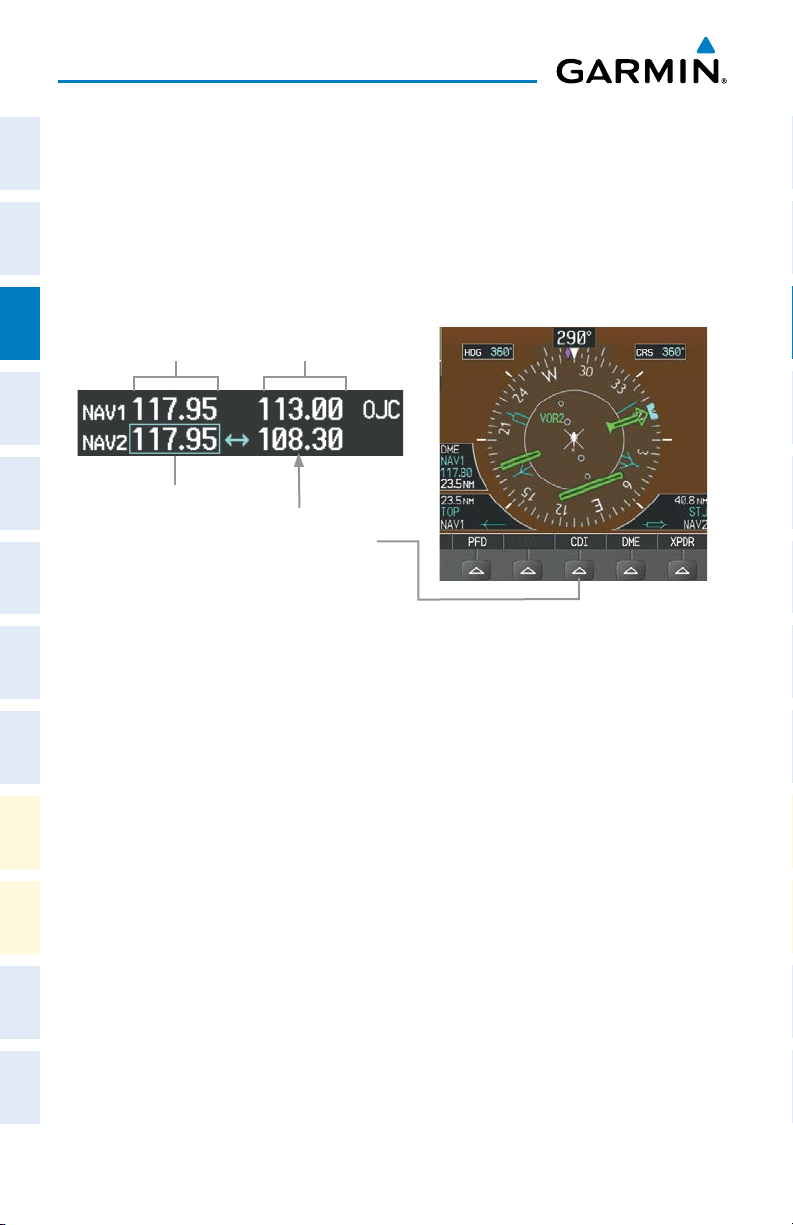
CHANGE NAVIGATION SOURCES
1)
Press the CDI Softkey to change from GPS to VOR1 or LOC1. This places
the light blue tuning box over the NAV1 standby frequency in the upper left
corner of the PFD.
2)
Press the CDI Softkey again to change from VOR1 or LOC1 to VOR2
or LOC2. This places the light blue tuning box over the NAV2 standby
frequency.
3)
Press the CDI Softkey a third time to return to GPS.
Com/Nav/
XPDR GPS Nav
Planning Procedures
Flight
Avoidance
Hazard
Additional
Features
Operation Annun/Alerts Appendix Index
Abnormal
190-01515-00 Rev. B
Garmin G1000H Cockpit Reference Guide for the AgustaWestland AW119Kx
1
Page 20

Flight Instruments
ENABLE/DISABLE OBS MODE WHILE NAVIGATING WITH GPS
Flight
1)
InstrumentsEIS
Press the OBS Softkey to select OBS Mode.
2)
Turn a CRS Knob to select the desired course to/from the waypoint. Press a
CRS Knob to synchronize the Selected Course with the bearing to the next
waypoint.
3)
Press the OBS Softkey again to disable OBS Mode.
XPDRGPS Nav
Com/Nav/
GENERIC TIMER
1)
Press the TMR/REF Softkey, then turn the large FMS Knob to select the
time field (hh/mm/ss). Turn the FMS Knobs to set the desired time, then
press the ENT Key. The UP/DOWN field is now highlighted.
2)
Turn the small FMS Knob to display the UP/DOWN window. Turn the FMS
Flight
PlanningProcedures
Knob to select ‘UP’ or ‘DOWN’, then press the ENT Key. ‘START?’ is now
highlighted.
3)
Press the ENT Key to START, STOP, or RESET the timer (if the timer is
counting DOWN, it starts counting UP after reaching zero). Press the CLR
Key or the TMR/REF Softkey to remove the window.
SET BAROMETRIC/RADAR ALTIMETER (OPTIONAL) MINIMUM DESCENT
Hazard
Avoidance
ALTITUDE
Features
Additional
Abnormal
OperationAnnun/AlertsAppendixIndex
1)
Press the
2)
Turn the large FMS Knob to highlight the Minimums field.
3)
Turn the small FMS Knob to select the barometric (BARO), TEMP COMP
TMR/REF
Softkey.
baro or radar altimeter (RAD ALT) altitude source. OFF is selected by
default. Press the ENT Key or turn the large FMS Knob to highlight the
next field.
4)
Use the small FMS Knob to enter the desired altitude (BARO or TEMP
COMP from zero to 16,000 feet, RAD ALT from zero to 2,500 feet ). If
TEMP COMP was selected, a field for entering the airport temperature and
altitude will appear. Press the ENT Key or turn the large FMS Knob to
highlight this field, and use the small FMS Knob to enter the temperature.
5)
To remove the window, press the
2
Garmin G1000H Cockpit Reference Guide for the AgustaWestland AW119Kx
CLR
Key or press the
TMR/REF
190-01515-00 Rev. B
Softkey.
Page 21

Flight Instruments
DISPLAYING WIND DATA
1)
Press the PFD Softkey.
2)
Press the WIND Softkey to display wind data to the left of the HSI.
3)
Press one of the OPTN softkeys to change how wind data is displayed.
4)
To remove the Wind Data Window, press the OFF Softkey.
CHANGING HSI FORMAT
1)
Press the PFD Softkey.
2)
Press the HSI FRMT Softkey.
3)
Press the 360 HSI Softkey to display the full size HSI.
Or
:
Press the ARC HSI Softkey to display the arc style HSI.
ENABLE HEADING PRESET MODE
1)
Press the SET HDG Softkey on the PFD. The system is in Heading Preset
Mode (HPM) as indicated by displaying ‘SET’ to the left of the heading
value.
2)
Press the HDG + and/or HDG - Softkeys to slew the heading value to the
desired setting.
Or
:
Set the Selected Heading Bug to the desired heading value, then press the
HDG SYNC Softkey.
Instruments EIS
Flight
Com/Nav/
XPDR GPS Nav
Planning Procedures
Flight
Avoidance
Hazard
Additional
Features
Operation Annun/Alerts Appendix Index
Abnormal
190-01515-00 Rev. B
Garmin G1000H Cockpit Reference Guide for the AgustaWestland AW119Kx
3
Page 22

Flight Instruments
DISABLE HEADING PRESET MODE
Flight
InstrumentsEIS
Press the HPM OFF Softkey on the PFD to manually disable Heading Preset
Mode.
Or
:
Heading Preset Mode automatically disables after eight minutes.
If there is more than 10° difference between the Heading Preset value and the
XPDRGPS Nav
magnetic heading when Heading Preset Mode is disabled, the heading value is
Com/Nav/
displayed in yellow and ‘ALN’ will be displayed to the left of the heading. When the
magnetic heading has properly aligned, the heading value will be displayed in white
and ‘ALN’ will no longer be displayed.
Flight
PlanningProcedures
Hazard
Avoidance
Features
Additional
Abnormal
OperationAnnun/AlertsAppendixIndex
4
Garmin G1000H Cockpit Reference Guide for the AgustaWestland AW119Kx
190-01515-00 Rev. B
Page 23
Engine Indication System
ENGINE INDICATION SYSTEM
NOTE: Refer to the Rotorcraft Flight Manual (RFM) for limitations.
Instruments EIS
Flight
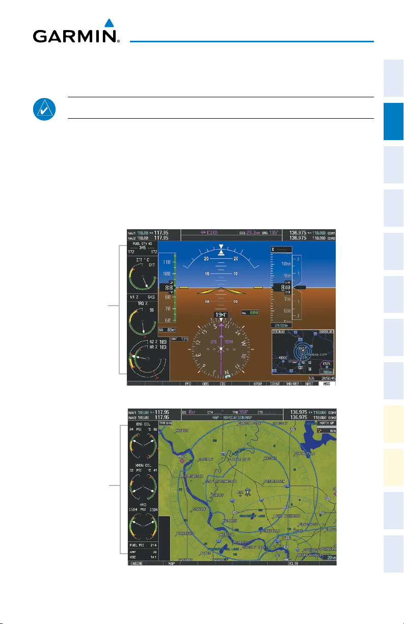
The G1000H Engine Indication System (EIS) displays critical engine, electrical,
fuel, and other system parameters on the left side of the Primary Flight Display (PFD)
Com/Nav/
XPDR GPS Nav
and Multi Function Display (MFD) during normal operations (Figure 3-1). EIS
information can be fully expanded to an entire page (EIS - Engine Page) using the
ENGINE Softkey on the MFD or using the START/AUTOROT pushbutton on the
Cyclic.
PFD
Planning Procedures
Flight
EIS Strip
Avoidance
Hazard
Additional
Features
MFD
Operation Annun/Alerts Appendix Index
Abnormal
EIS Strip
190-01515-00 Rev. B
EIS (Normal)
Garmin G1000H Cockpit Reference Guide for the AgustaWestland AW119Kx
5
Page 24

Engine Indication System
Flight
InstrumentsEIS
XPDRGPS Nav
Com/Nav/
Flight
PlanningProcedures
Hazard
Avoidance
Features
Additional
Abnormal
OperationAnnun/AlertsAppendixIndex
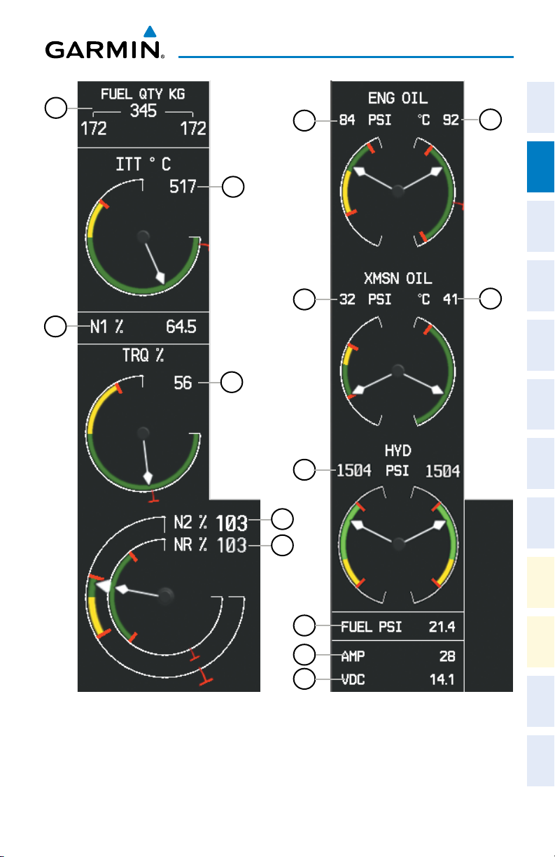
Fuel Quantity Indicator
1
(FUEL QTY KG)
2
Inter Turbine Temperature
(ITT)
3
Gas Generator Speed (N1)
4
Torque (TRQ)
5
Power Turbine Speed (N2)
6
Rotor Speed (NR)
Oil Pressure Indicator
7
(ENG OIL PSI)
8
Oil Temperature Indicator
(ENG OIL ºC)
9
Transmission Oil Pressure
(XMSN OIL PSI)
10
Transmission Oil
Temperature (XMSN
OIL ºC)
Hydraulic Pressure
11
(HYD PSI)
12
Fuel PSI
Displays the quantity of fuel in each fuel tank
as well as the total fuel.
Displays the current Inter Turbine Air
Temperature (˚ Celsius).
Displays a digital readout of the Gas Generator
Compressor Speed as a percentage.
Displays current fuel engine Torque as a
percentage.
Displays current Power Turbine Speed as a
percentage on a round dial, a digital readout
is shown to the side.
Displays Rotor Speed as a percentage, a digital
readout is shown to the side.
Displays the oil pressure supplied to the engine
in pounds per square inch
Displays engine oil temperature (˚ Celsius).
Display the pressure of oil supplied to the
transmission in pounds per square inch.
Displays the transmission oil temperature (˚
Celsius).
Displays the current Hydraulic Pressure for
both hydraulic systems (1 and 2) in pounds
per square inch.
Displays the current Fuel Pressure in pounds
per square inch
Generator Ammeter
13
(AMP)
14
Generator Voltmeter
(VDC)
6
Garmin G1000H Cockpit Reference Guide for the AgustaWestland AW119Kx
Displays the generator load in amperes
Displays the generator voltage.
190-01515-00 Rev. B
Page 25
Engine Indication System
Instruments EIS
Flight
1
7
2
8
Com/Nav/
XPDR GPS Nav
9
3
10
Planning Procedures
Flight
4
Avoidance
Hazard
11
Additional
Features
5
6
Operation Annun/Alerts Appendix Index
Abnormal
12
13
14
190-01515-00 Rev. B
EIS Display (PFD)
Garmin G1000H Cockpit Reference Guide for the AgustaWestland AW119Kx
EIS Display (MFD)
7
Page 26

Engine Indication System
ENGINE PAGE
Flight
Pressing the ENGINE Softkey or the START/AUTOROT pushbutton on the
InstrumentsEIS
Cyclic, displays the EIS - ENGINE Page which provides a full screen view of all
engine instruments. The EIS-Engine Page is automatically displayed when N1 <
51%.
Engine Parameters
1
XPDRGPS Nav
Com/Nav/
2
3
Flight
PlanningProcedures
4
5
Fuel System
Hazard
Avoidance
6
Features
Additional
7
Power Turbine Speed
(N2)
Rotor Speed (NR)
Torque (TRQ)
Gas Generator Speed
(N1)
Inter Turbine
Temperature (ITT)
Fuel Quantity
Indicator
(FUEL QTY KG)
Fuel PSI
Displays current Power Turbine Speed as a
percentage on a round dial, a digital readout is
shown to the side.
Displays Rotor Speed as a percentage, a digital
readout is shown to the side.
Displays current fuel engine Torque as a
percentage.
Displays a digital readout of the Gas Generator
Compressor Speed as a percentage.
Displays the current Inter Turbine Air Temperature
(˚ Celsius).
Displays the quantity of fuel in each fuel tank as
well as the total fuel in KG.
Displays the current Fuel Pressure in pounds per
square inch
Electrical System
Abnormal
OperationAnnun/AlertsAppendixIndex
Generator Voltmeter
8
9
Generator Ammeter
Hydraulic System
10
Hydraulic Pressure
8
Garmin G1000H Cockpit Reference Guide for the AgustaWestland AW119Kx
(VOLT)
(AMP)
(HYD PSI)
Displays the primary generator voltage.
Displays the generator load in amperes
Displays the current Hydraulic Pressure for both
hydraulic systems in pounds per square inch.
190-01515-00 Rev. B
Page 27
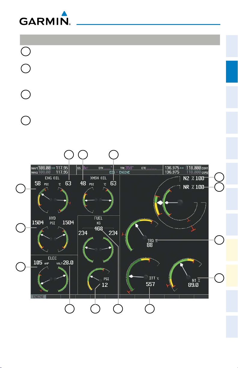
Engine/Transmission Oil
Oil Pressure Indicator
11
(ENG OIL PSI)
12
Oil Temperature
Indicator
(ENG OIL ºC)
13
Transmission Oil
Pressure (XMSN
OIL PSI)
14
Transmission Oil
Temperature (XMSN
OIL ºC)
12
11
13
Engine Indication System
Displays the oil pressure supplied to the engine in
pounds per square inch
Displays engine oil temperature (˚ Celsius).
Display the pressure of oil supplied to the
transmission in pounds per square inch.
Displays the transmission oil temperature
(˚ Celsius).
14
1
2
Instruments EIS
Flight
Com/Nav/
XPDR GPS Nav
Planning Procedures
Flight
Avoidance
Hazard
10
9
190-01515-00 Rev. B
78
6 5
Engine Page Display (MFD)
Garmin G1000H Cockpit Reference Guide for the AgustaWestland AW119Kx
Additional
Features
3
Operation Annun/Alerts Appendix Index
Abnormal
4
9
Page 28

Engine Indication System
Flight
InstrumentsEIS
XPDRGPS Nav
Com/Nav/
Flight
PlanningProcedures
Blank Page
Hazard
Avoidance
Features
Additional
Abnormal
OperationAnnun/AlertsAppendixIndex
10
Garmin G1000H Cockpit Reference Guide for the AgustaWestland AW119Kx
190-01515-00 Rev. B
Page 29
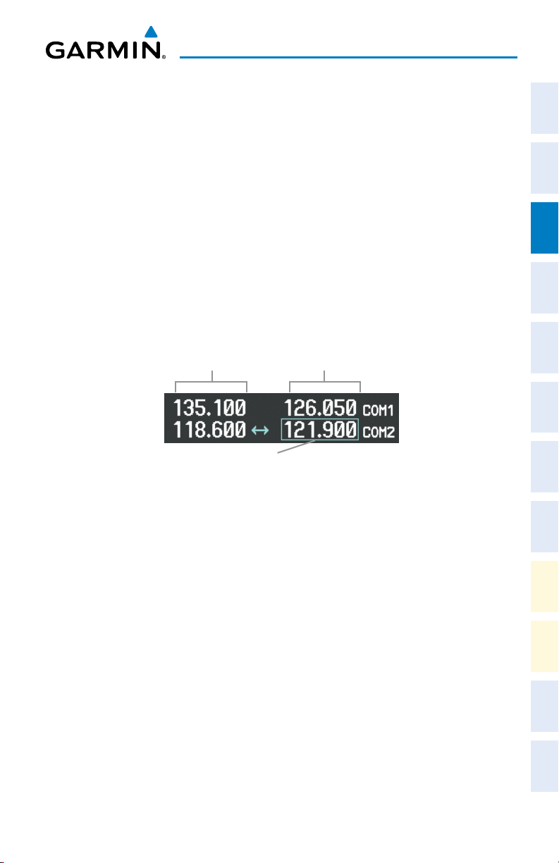
COM/NAV TUNING
1)
Press the small tuning knob to select the desired radio for tuning. A light
blue box highlights the radio frequency to be tuned.
2)
Turn the respective tuning knobs to enter the desired frequency into the
standby frequency field. The large knob enters MHz and the small knob
enters kHz.
3)
Press the Frequency Transfer Key to place the frequency into the active
frequency field.
Com/Nav/Transponder
COM/NAV/TRANSPONDER
Active
Fields
Tuning Box
Standby
Fields
Instruments EIS
Flight
Com/Nav/
XPDR GPS Nav
Planning Procedures
Flight
Avoidance
Hazard
Selecting a COM Radio for Transmit
Features
SELECTING A NAV RADIO
A NAV radio is selected for navigation by pressing the CDI Softkey located on the
Operation Annun/Alerts Appendix Index
PFD. Pressing the CDI Softkey once selects NAV1 as the navigation radio. Pressing
the CDI Softkey a second time selects NAV2 as the navigation radio. Pressing the CDI
Softkey a third time activates GPS mode. Pressing the CDI Softkey again cycles back
to NAV1.
While cycling through the CDI Softkey selections, the NAV Tuning Box and the
Frequency Transfer Arrow are placed in the active NAV Frequency Field.
190-01515-00 Rev. B
Garmin G1000H Cockpit Reference Guide for the AgustaWestland AW119Kx
11
Additional
Abnormal
Page 30
Com/Nav/Transponder
The three navigation modes that can be cycled through are:
Flight
• VOR1 (or LOC1) – If NAV1 is selected, a green single line arrow (not shown)
InstrumentsEIS
labeled either VOR1 or LOC1 is displayed on the HSI.
• VOR2 (or LOC2) – If NAV2 is selected, a green double line arrow (shown) labeled
either VOR2 or LOC2 is displayed on the HSI.
• GPS – If GPS Mode is selected, a magenta single line arrow (not shown) appears
on the HSI and neither NAV radio is selected.
XPDRGPS Nav
Com/Nav/
Flight
PlanningProcedures
Standby
Fields
Tuning Box
The NAV Radio is Selected
Active
Fields
by Pressing the
CDI
Softkey
Selecting a NAV Radio for Navigation
Hazard
Avoidance
NAV radios are selected for listening by switching the corresponding knob on the
remote Audio Panel to the “IN” position and by pressing the NAV VOL/ID Knob on
the PFD or MFD.
Features
Additional
ENTER A TRANSPONDER CODE
1)
Abnormal
OperationAnnun/AlertsAppendixIndex
Press the XPDR Softkey to display the transponder mode selection softkeys.
2)
Press the CODE Softkey to display the transponder code selection softkeys,
for digit entry.
3)
Press the digit softkeys to enter the code in the code field. When entering
the code, the next key in sequence must be pressed within 10 seconds, or
the entry is cancelled and restored to the previous code. Five seconds after
the fourth digit has been entered, the transponder code becomes active.
12
Garmin G1000H Cockpit Reference Guide for the AgustaWestland AW119Kx
190-01515-00 Rev. B
Page 31

GPS NAVIGATION
DIRECT-TO NAVIGATION
Direct-to Navigation from the MFD
1)
Press the Direct-to
2)
Enter the waypoint identifier.
3)
Press the ENT Key to confirm the identifier. The ‘Activate?’ field is
highlighted.
4)
If no altitude constraint or course is desired, press the ENT Key to activate.
To enter an altitude constraint, proceed to step 5.
5)
Turn the large FMS Knob to place the cursor over the ‘VNV’ altitude field.
6)
Enter the desired altitude.
7)
Press the ENT Key. If the waypoint entered is an airport, the option to
select MSL or AGL is now displayed. If the waypoint is not an airport,
proceed to step 9.
8)
Turn the small FMS Knob to select ‘MSL’ or ‘AGL’.
9)
Press the ENT Key. The cursor is now flashing in the VNV offset distance
field.
10)
Enter the desired offset distance before (-) the waypoint.
11)
Press the ENT Key. The ‘Activate?’ field is highlighted.
12)
Press the ENT Key to activate.
Direct-to Navigation from the PFD
( )
Key.
GPS Navigation
Instruments EIS
Flight
Com/Nav/
XPDR GPS Nav
Planning Procedures
Flight
Avoidance
Hazard
Additional
Features
Operation Annun/Alerts Appendix Index
Abnormal
1)
Press the Direct-to Key
2)
Turn the large FMS Knob to place the cursor in the desired selection field.
3)
Turn the small FMS Knob to begin selecting the desired identifier, location,
etc.
4)
Press the ENT Key.
5)
The cursor is now flashing on ‘ACTIVATE?’. If no altitude constraint or
course is desired, press the ENT Key to activate. To enter an altitude
constraint, proceed to step 6.
6)
Turn the large FMS Knob to place the cursor over the ‘ALT’ altitude field.
190-01515-00 Rev. B
( )
.
Garmin G1000H Cockpit Reference Guide for the AgustaWestland AW119Kx
13
Page 32

GPS Navigation
7)
Turn the small FMS Knob to enter the desired altitude.
8)
Flight
InstrumentsEIS
Press the ENT Key. If the waypoint entered is an airport, the option to
select MSL or AGL is now displayed. If the waypoint is not an airport,
proceed to step 10.
9)
Turn the small FMS Knob to select ‘MSL’ or ‘AGL’.
10)
Press the ENT Key. The cursor is placed in the OFFSET distance field.
11)
XPDRGPS Nav
Com/Nav/
Turn the small FMS Knob to enter the desired target altitude offset from
the selected Direct-to.
12)
Press the ENT Key to highlight ‘Activate?’ or turn the large FMS Knob to
highlight the ‘CRS’ field.
13)
Turn the small FMS Knob to enter the desired course to the waypoint.
14)
Press the ENT Key to highlight ‘ACTIVATE?’.
15)
Flight
PlanningProcedures
Press the ENT again to activate the Direct-to.
ACTIVATE A STORED FLIGHT PLAN
1)
Press the FPL Key on the MFD and turn the small FMS Knob to display the
Flight Plan Catalog Page.
2)
Hazard
Avoidance
Features
Additional
Press the FMS Knob to activate the cursor.
3)
Turn the large FMS Knob to highlight the desired flight plan
4)
Press the ACTIVE Softkey. The confirmation window is now displayed.
5)
With ‘OK’ highlighted, press the ENT Key to activate the flight plan. To cancel
the flight plan activation, turn the large FMS Knob to highlight ‘CANCEL’ and
press the ENT Key.
Abnormal
OperationAnnun/AlertsAppendixIndex
ACTIVATE A FLIGHT PLAN LEG
1)
From the Active Flight Plan Page, press the FMS Knob to activate the cursor
and turn the large FMS Knob to highlight the desired waypoint.
2)
Press the ACT LEG Softkey on the MFD.
OR
3)
Press the MENU Key, select the ‘Activate Leg’ option from the page menu
and press the ENT Key. This step must be used when activating a leg from
the PFD.
4)
With ‘Activate’ highlighted, press the ENT Key.
14
Garmin G1000H Cockpit Reference Guide for the AgustaWestland AW119Kx
190-01515-00 Rev. B
Page 33

GPS Navigation
STOP NAVIGATING A FLIGHT PLAN
1)
Press the FPL Key to display the Active Flight Plan Page.
2)
Press the MENU Key to display the Page Menu Window.
3)
Turn the large FMS Knob to highlight ‘Delete Flight Plan’ and press the ENT
Instruments EIS
Flight
Key. With ‘OK’ highlighted, press the ENT Key to deactivate the flight plan.
This does not delete the stored flight plan, only the active flight plan.
Com/Nav/
XPDR GPS Nav
VERTICAL NAVIGATION (VNAV)
The navigation database only contains altitudes for procedures that call for “Cross
at” altitudes. If the procedure states “Expect to cross at,” the altitude is not in the
database. In this case the altitude may be entered manually.
Planning Procedures
NOTE: Temperature Compensated (TEMP COMP) altitudes are depicted as
slanted text.
Large White
Text
Large Light
Blue Text
Flight
Avoidance
Hazard
Additional
Features
190-01515-00 Rev. B
Small Light
Blue Text
Small Light
Blue Subdued
Text
Small White Text
with Altitude
Restriction Bar
Cross AT or ABOVE 5,000 ft
Cross AT 2,300 ft
Cross AT or BELOW 3,000 ft
Garmin G1000H Cockpit Reference Guide for the AgustaWestland AW119Kx
15
Operation Annun/Alerts Appendix Index
Abnormal
Page 34

GPS Navigation
Altitudes associated with approach procedures are “auto-designated”. This means
the system automatically uses the altitudes loaded with the approach for giving vertical
Flight
InstrumentsEIS
flight path guidance outside the FAF. Note these altitudes are displayed as small light
blue text.
Altitudes associated with arrival procedures are “manually-designated”. This means
the system does not use the altitudes loaded with the arrival for giving vertical flight
path guidance until designated to do so by the pilot. Note that these altitudes are
initially displayed as white text. These altitudes may be “designated” by placing the
XPDRGPS Nav
Com/Nav/
cursor over the desired altitude and pressing the ENT Key. After designation, the text
changes to light blue.
Altitudes that have been designated for use in vertical navigation may also be
made “non-designated” by placing the cursor over the desired altitude and pressing
the CLR Key. The altitude is now displayed only as a reference. It will not be used
to give vertical flight path guidance. Other displayed altitudes may change due to
Flight
PlanningProcedures
re-calculations or rendered invalid as a result of manually changing an altitude to a
non-designated altitude.
White Text Light Blue Text Light Blue
Subdued Text
Hazard
Avoidance
Features
Additional
Abnormal
OperationAnnun/AlertsAppendixIndex
Large Text
Small Text
16
Altitude calculated by the
system estimating the
altitude of the aircraft as it
passes over the navigation
point. This altitude is
provided as a reference
and is not designated to
be used in determining
vertical flight path
Altitude has been entered
by the pilot. Altitude is
designated for use in
giving vertical flight path
guidance. Altitude does
not match the published
altitude in navigation
database or no published
altitude exists.
The system cannot
use this altitude in
determining vertical
flight path guidance.
guidance.
Altitude is not designated
to be used in determining
vertical flight path
guidance. Altitude has
been retrieved from the
navigation database and
is provided as a reference.
Altitude is designated for
use in giving vertical flight
path guidance. Altitude
has been retrieved from
the navigation database
or has been entered by
the pilot and matches a
The system cannot
use this altitude in
determining vertical
flight path guidance.
published altitude in the
navigation database.
Garmin G1000H Cockpit Reference Guide for the AgustaWestland AW119Kx
190-01515-00 Rev. B
Page 35

GPS Navigation
Instruments EIS
Flight
NOTE: Making course changes greater than 90° during a descent with vertical
guidance may cause excessive and rapid movement of the vertical deviation
indicator, and SVS Pathways.
The system updates vertical path guidance continuously using ground speed and
the calculated distance to the Bottom of Descent (BOD). Due to turn anticipation
Com/Nav/
guidance (turn-smoothing), distance to the BOD can be affected by course changes
XPDR GPS Nav
greater than approximately 5 degrees. Ground speed can be affected by factors such as
shifts in wind direction, aircraft power management, pitch angle, and course changes.
Abrupt and/or substantial changes to either the distance to the BOD, ground speed, or
both can cause similarly abrupt/substantial changes in vertical path guidance.
Because of turn-smoothing, changes to both distance to the BOD and ground speed
tend to be more extreme when the BOD is also a waypoint that marks a large course
Planning Procedures
Flight
change. These speed and distance changes will be accounted for in the computed
required vertical path and reflected in the vertical guidance indications.
Avoidance
Hazard
190-01515-00 Rev. B
Garmin G1000H Cockpit Reference Guide for the AgustaWestland AW119Kx
17
Additional
Features
Operation Annun/Alerts Appendix Index
Abnormal
Page 36

GPS Navigation
Flight
InstrumentsEIS
XPDRGPS Nav
Com/Nav/
Flight
PlanningProcedures
Blank Page
Hazard
Avoidance
Features
Additional
Abnormal
OperationAnnun/AlertsAppendixIndex
18
Garmin G1000H Cockpit Reference Guide for the AgustaWestland AW119Kx
190-01515-00 Rev. B
Page 37

FLIGHT PLANNING
TRIP PLANNING
All procedures apply to the MFD unless otherwise stated.
1)
Turn the large FMS Knob to select the ‘AUX’ page group.
2)
Turn the small FMS Knob to select the Trip Planning Page.
3)
The current ‘PAGE MODE’ is displayed at the top of the page: ‘AUTOMATIC’
or ‘MANUAL’. To change the page mode, press the AUTO or MANUAL
Softkey.
4)
For Direct-to planning:
a)
Press the WPTS Softkey and verify that the starting waypoint field
indicates ‘P.POS’ (present position).
b)
If necessary, press the MENU Key and select ‘Set WPT to Present
Position’ to display ‘P.POS’.
c)
Press the ENT Key and the flashing cursor moves to the ending
waypoint field.
d)
Enter the identifier of the ending waypoint and press the ENT Key to
accept the waypoint.
Or:
For point-to-point planning:
a)
Enter the identifier of the starting waypoint.
b)
Once the waypoint’s identifier is entered, press the ENT Key to accept
the waypoint. The flashing cursor moves to the ending waypoint.
c)
Again, enter the identifier of the ending waypoint.
d)
Press the ENT Key to accept the waypoint.
Or:
For flight plan leg planning:
a)
Press the FPL Softkey (at the bottom of the display).
b)
Turn the small FMS Knob to select the desired flight plan (already
stored in memory), by number.
c)
Turn the large FMS Knob to highlight the ‘LEG’ field.
Flight Planning
Instruments EIS
Flight
Com/Nav/
XPDR GPS Nav
Planning Procedures
Flight
Avoidance
Hazard
Additional
Features
Operation Annun/Alerts Appendix Index
Abnormal
190-01515-00 Rev. B
Garmin G1000H Cockpit Reference Guide for the AgustaWestland AW119Kx
19
Page 38

Flight Planning
d)
Flight
InstrumentsEIS
XPDRGPS Nav
Com/Nav/
Flight
PlanningProcedures
Hazard
Avoidance
Features
Additional
Abnormal
OperationAnnun/AlertsAppendixIndex
5)
Turn the large FMS Knob to highlight the departure time (DEP TIME) field.
6)
Enter the departure time. Press the ENT Key when finished. Departure time
may be entered in local or UTC time, depending upon system settings.
7)
The flashing cursor moves to the ground speed (GS) field. Enter the ground
speed. Press the
mode, ground speed is provided by the system.
8)
The flashing cursor moves to the fuel flow field. Enter the fuel flow. Press
the ENT Key when finished. Note that in ‘AUTOMATIC’ page mode, fuel flow
is provided by the system.
9)
The flashing cursor moves to the fuel onboard field. Enter the fuel onboard.
Press the ENT Key when finished. Note that in ‘AUTOMATIC’ page mode, fuel
onboard is provided by the fuel totalizer.
10)
The flashing cursor moves to the calibrated airspeed (CALIBRATED AS) field.
Enter the calibrated airspeed. Press the ENT Key when finished. Note that
in ‘AUTOMATIC’ page mode, calibrated airspeed is provided by the system.
11)
The flashing cursor moves to the altitude (IND ALTITUDE) field. Enter the
altitude. Press the ENT Key when finished. Note that in ‘AUTOMATIC’ page
mode, altitude is provided by the system.
12)
The flashing cursor moves to the barometric setting (PRESSURE) field. Enter
the desired baro setting. Press the ENT Key when finished. Note that in
‘AUTOMATIC’ page mode, the baro setting is provided by the setting entered
on the PFD.
13)
The flashing cursor moves to the air temperature (TOTAL AIR TEMP) field. Enter
the desired air temperature. Press the ENT Key when finished. Note that in
‘AUTOMATIC’ page mode, air temperature is provided by the system outside
air temperature.
Turn the small FMS Knob to select the desired leg of the flight plan, or
select ‘CUM’ to apply trip planning calculations to the entire flight plan.
Selecting ‘FPL 00’ displays the active flight plan. If an active flight plan
is selected, ‘REM’ is an available option to display planning data for the
remainder of the flight plan.
NOTE:
The page mode must be set to ‘MANUAL’ to perform the following steps.
NOTE: The departure time on the Trip Planning Page is used for preflight
planning. Refer to the Utility Page for the actual flight departure time.
ENT
Key when finished. Note that in ‘automatic’ page
20
Garmin G1000H Cockpit Reference Guide for the AgustaWestland AW119Kx
190-01515-00 Rev. B
Page 39

Flight Planning
CREATE A USER WAYPOINT DEFINED BY LATITUDE & LONGITUDE
1)
Turn the large FMS Knob on the MFD to select the ‘WPT’ page group.
2)
Turn the small FMS Knob to select the User WPT Information Page.
3)
Press the NEW Softkey. A waypoint is created at the current aircraft
position.
4)
Enter the desired waypoint name.
5)
Press the ENT Key.
6)
The cursor is now in the ‘WAYPOINT TYPE’ field. If desired, the waypoint
can be made temporary (deleted automatically when the system is turned
off). If the waypoint is to remain in the system, proceed to step 7.
a)
Turn the large FMS Knob one click to the left to highlight
‘TEMPORARY’.
b)
Press the ENT Key to place a check-mark in the box. Turn the large
FMS Knob to place the cursor back in the ‘WAYPOINT TYPE’ field.
7)
With the cursor in the ‘WAYPOINT TYPE’ field, turn the small FMS Knob to
display a list of waypoint types.
8)
Turn the small FMS Knob to select LAT/LON (latitude and longitude).
9)
Press the ENT Key.
Instruments EIS
Flight
Com/Nav/
XPDR GPS Nav
Planning Procedures
Flight
Avoidance
Hazard
CREATE A USER WAYPOINT DEFINED BY RADIALS FROM OTHER WAYPOINTS
1)
Turn the large FMS Knob on the MFD to select the ‘WPT’ page group.
2)
Turn the small FMS Knob to select the User WPT Information Page.
3)
Press the NEW Softkey. A waypoint is created at the current aircraft
position.
4)
Enter the desired waypoint name.
5)
Press the ENT Key.
6)
The cursor is now in the ‘WAYPOINT TYPE’ field. If desired, the waypoint
can be made temporary (deleted automatically when the system is turned
off). If the waypoint is to remain in the system, proceed to step 7.
a)
Turn the large FMS Knob one click to the left to highlight
‘TEMPORARY’.
b)
Press the ENT Key to place a check-mark in the box. Turn the large
FMS Knob to place the cursor back in the ‘WAYPOINT TYPE’ field.
190-01515-00 Rev. B
Garmin G1000H Cockpit Reference Guide for the AgustaWestland AW119Kx
21
Additional
Features
Operation Annun/Alerts Appendix Index
Abnormal
Page 40

Flight Planning
7)
With the cursor in the ‘WAYPOINT TYPE’ field, turn the small FMS Knob to
Flight
InstrumentsEIS
XPDRGPS Nav
Com/Nav/
Flight
PlanningProcedures
Hazard
Avoidance
Features
Additional
Abnormal
OperationAnnun/AlertsAppendixIndex
display a list of waypoint types.
8)
Turn the small FMS Knob to select RAD/RAD (radial/radial).
9)
Press the ENT Key.
10)
The cursor moves to the ‘REFERENCE WAYPOINTS’ field. With the first
waypoint name highlighted, use the FMS Knobs to enter the desired
waypoint name. Waypoints may also be selected as follows:
a)
b)
c)
Or:
a)
b)
c)
d)
Or:
a)
b)
c)
d)
Or:
a)
b)
c)
d)
When a flight plan is active, turning the small FMS Knob to the left will
display a list of the flight plan waypoints.
Turn the large FMS Knob to select the desired waypoint.
Press the ENT Key.
Turn the small FMS Knob to the left. Initially, a flight plan waypoint list
is displayed.
Turn the small FMS Knob to the right to display the ‘NRST’ airports to
the aircraft’s current position.
Turn the large FMS Knob to select the desired waypoint.
Press the ENT Key.
Turn the small FMS Knob to the left. Initially, a flight plan waypoint list
is displayed.
Turn the small FMS Knob to the right to display the ‘RECENT’
waypoints.
Turn the large FMS Knob to select the desired waypoint.
Press the ENT Key.
Turn the small FMS Knob to the left. Initially, a flight plan waypoint list
is displayed.
Turn the small FMS Knob to the right to display the ‘USER’ waypoints.
Turn the large FMS Knob to select the desired waypoint.
Press the ENT Key.
22
Garmin G1000H Cockpit Reference Guide for the AgustaWestland AW119Kx
190-01515-00 Rev. B
Page 41

Flight Planning
11)
Press the ENT Key. The cursor is displayed in the ‘RAD’ (radial) field. Enter
the desired radial from the reference waypoint.
12)
Press the ENT Key.
13)
Repeat step 10 to enter the next waypoint name.
14)
Press the ENT Key. The cursor is displayed in the ‘RAD’ (radial) field for the
second waypoint. Enter the desired radial from the reference waypoint.
15)
Press the ENT Key.
16)
Press the FMS Knob to remove the flashing cursor.
CREATE A USER WAYPOINT DEFINED BY A RADIAL & DISTANCE FROM
ANOTHER WAYPOINT
1)
Turn the large FMS Knob on the MFD to select the ‘WPT’ page group.
2)
Turn the small FMS Knob to select the User WPT Information Page.
3)
Press the NEW Softkey. A waypoint is created at the current aircraft
position.
4)
Enter the desired waypoint name.
5)
Press the ENT Key.
6)
The cursor is now in the ‘WAYPOINT TYPE’ field. If desired, the waypoint
can be made temporary (deleted automatically when the system is turned
off). If the waypoint is to remain in the system, proceed to step 7.
a)
Turn the large FMS Knob one click to the left to highlight
‘TEMPORARY’.
b)
Press the ENT Key to place a check-mark in the box. Turn the large
FMS Knob to place the cursor back in the ‘WAYPOINT TYPE’ field.
7)
With the cursor in the ‘WAYPOINT TYPE’ field, turn the small FMS Knob to
display a list of waypoint types.
8)
Turn the small FMS Knob to select RAD/DIS (radial/distance).
9)
Press the ENT Key.
10)
The cursor moves to the ‘REFERENCE WAYPOINTS’ field. With the first
waypoint name highlighted, use the FMS Knobs to enter the desired
waypoint name. Waypoints may also be selected as follows:
Instruments EIS
Flight
Com/Nav/
XPDR GPS Nav
Planning Procedures
Flight
Avoidance
Hazard
Additional
Features
Operation Annun/Alerts Appendix Index
Abnormal
190-01515-00 Rev. B
Garmin G1000H Cockpit Reference Guide for the AgustaWestland AW119Kx
23
Page 42

Flight Planning
a)
Flight
InstrumentsEIS
b)
c)
Or:
a)
XPDRGPS Nav
Com/Nav/
Flight
PlanningProcedures
Hazard
Avoidance
Features
Additional
Abnormal
OperationAnnun/AlertsAppendixIndex
b)
c)
d)
Or:
a)
b)
c)
d)
Or:
a)
b)
c)
d)
11)
Press the ENT Key. The cursor is displayed in the ‘RAD’ (radial) field. Enter
the desired radial from the reference waypoint.
12)
Press the ENT Key.
13)
The cursor is now displayed in the ‘DIS’ (distance) field. Enter the desired
distance from the reference waypoint.
14)
Press the ENT Key.
When a flight plan is active, turning the small FMS Knob to the left will
display a list of the flight plan waypoints.
Turn the large FMS Knob to select the desired waypoint.
Press the ENT Key.
Turn the small FMS Knob to the left. Initially, a flight plan waypoint list
is displayed.
Turn the small FMS Knob to the right to display the ‘NRST’ airports to
the aircraft’s current position.
Turn the large FMS Knob to select the desired waypoint.
Press the ENT Key.
Turn the small FMS Knob to the left. Initially, a flight plan waypoint list
is displayed.
Turn the small FMS Knob to the right to display the ‘RECENT’
waypoints.
Turn the large FMS Knob to select the desired waypoint.
Press the ENT Key.
Turn the small FMS Knob to the left. Initially, a flight plan waypoint list
is displayed.
Turn the small FMS Knob to the right to display the ‘USER’ waypoints.
Turn the large FMS Knob to select the desired waypoint.
Press the ENT Key.
15)
Press the FMS Knob to remove the flashing cursor.
24
Garmin G1000H Cockpit Reference Guide for the AgustaWestland AW119Kx
190-01515-00 Rev. B
Page 43

DELETE A USER WAYPOINT
1)
Turn the large FMS Knob to select the ‘WPT’ page group.
2)
Turn the small FMS Knob to select the User WPT Information Page.
3)
Press the FMS Knob to activate the cursor.
4)
Turn the large FMS Knob to the place the cursor in the ‘USER WAYPOINT LIST’
field.
5)
Turn the small FMS Knob to highlight the desired waypoint.
6)
Press the DELETE Softkey.
7)
The message ‘Would you like to delete the user waypoint?’ is displayed. With
‘YES’ highlighted, press the ENT Key.
CREATE A FLIGHT PLAN
NOTE: When creating a flight plan in the Active Flight Plan Window, the first
leg is activated automatically after it is created.
Flight Planning
Instruments EIS
Flight
Com/Nav/
XPDR GPS Nav
Planning Procedures
Flight
Creating an active flight plan:
1)
Press the FPL Key.
2)
Press the FMS Knob to activate the cursor (only on MFD).
3)
Turn the small FMS Knob to display the Waypoint Information Window.
(Turning it clockwise displays a blank Waypoint Information Window,
turning it counter-clockwise displays the Waypoint Information Window
with a waypoint selection submenu allowing selection of active flight plan,
nearest, recent, user, or airway waypoints).
4)
Enter the identifier, facility, or city name of the departure waypoint or select
a waypoint from the submenu of waypoints and press the ENT Key. The
active flight plan is modified as each waypoint is entered.
5)
Repeat step numbers 3 and 4 to enter each additional flight plan waypoint.
6)
When all waypoints have been entered, press the FMS Knob to remove the
cursor.
190-01515-00 Rev. B
Garmin G1000H Cockpit Reference Guide for the AgustaWestland AW119Kx
25
Avoidance
Hazard
Additional
Features
Operation Annun/Alerts Appendix Index
Abnormal
Page 44

Flight Planning
Creating a stored flight plan:
Flight
1)
InstrumentsEIS
Press the FPL Key.
2)
Turn the small FMS Knob clockwise to display the Flight Plan Catalog Page.
3)
Press the NEW Softkey; or press the MENU Key, highlight ‘Create New
Flight Plan’, and press the ENT Key to display a blank flight plan for the
first empty storage location.
4)
XPDRGPS Nav
Com/Nav/
Turn the small FMS Knob to display the Waypoint Information Window.
(Turning it clockwise displays a blank Waypoint Information Window,
turning it counter-clockwise displays the Waypoint Information Window
with a waypoint selection submenu allowing selection of active flight plan,
nearest, recent, user, or airway waypoints).
5)
Enter the identifier, facility, or city name of the departure waypoint or select
Flight
PlanningProcedures
a waypoint from the submenu of waypoints and press the ENT Key.
6)
Repeat step numbers 4 and 5 to enter each additional flight plan waypoint.
7)
When all waypoints have been entered, press the FMS Knob to return to
the Flight Plan Catalog Page. The new flight plan is now in the list.
IMPORT A FLIGHT PLAN FROM AN SD CARD
Hazard
Avoidance
Features
Additional
Abnormal
OperationAnnun/AlertsAppendixIndex
26
NOTE: See the Annunciations & Alerts section for flight plan import message
descriptions.
1)
Insert the SD card containing the flight plan in the top card slot on the
MFD.
2)
Press the FPL Key on the MFD to display the Active Flight Plan Page.
3)
Turn the small FMS Knob to select the Flight Plan Catalog Page.
4)
Press the FMS Knob to activate the cursor.
5)
Turn either FMS Knob to highlight an empty or existing flight plan.
6)
Press the IMPORT Softkey.
If an empty flight plan is selected, a list of the available flight plans on
the SD card will be displayed.
Garmin G1000H Cockpit Reference Guide for the AgustaWestland AW119Kx
190-01515-00 Rev. B
Page 45

Flight Planning
Or:
If an existing flight plan is selected, an ‘Overwrite existing flight plan?
OK or CANCEL’ prompt is displayed. Press the ENT Key to choose to
overwrite the selected flight plan and see a list of the available flight
plans on the SD card. If overwriting the existing flight plan is not
desired, select ‘CANCEL’ using the FMS Knob, press the ENT Key, select
another existing or empty flight plan, and again press the IMPORT
Softkey.
7)
Turn the small FMS Knob to highlight the desired flight plan for importing.
8)
Press the ENT Key.
Instruments EIS
Flight
Com/Nav/
XPDR GPS Nav
INSERT A WAYPOINT IN THE ACTIVE FLIGHT PLAN
1)
Press the FPL Key to display the active flight plan.
2)
If required, press the FMS Knob to activate the cursor.
3)
Turn the large FMS Knob to highlight the desired flight plan waypoint. The
new waypoint is inserted before the highlighted waypoint.
4)
Turn the small FMS Knob. The Waypoint Information Window is now
displayed.
5)
Enter the new flight plan waypoint by one of the following:
a)
Enter the user waypoint identifier, facility, or city.
b)
Press the ENT Key.
Or:
a)
Turn the small FMS Knob to the left. Initially, a flight plan waypoint list
is displayed.
b)
Turn the small FMS Knob to the right to display the ‘NRST’ airport
waypoints to the aircraft’s current position.
c)
Turn the large FMS Knob to select the desired waypoint.
d)
Press the ENT Key.
Or:
a)
Turn the small FMS Knob to the left. Initially, a flight plan waypoint list
is displayed.
b)
Turn the small FMS Knob to the right to display the ‘RECENT’
waypoints.
Planning Procedures
Flight
Avoidance
Hazard
Additional
Features
Operation Annun/Alerts Appendix Index
Abnormal
190-01515-00 Rev. B
Garmin G1000H Cockpit Reference Guide for the AgustaWestland AW119Kx
27
Page 46

Flight Planning
c)
Turn the large FMS Knob to select the desired waypoint.
Flight
InstrumentsEIS
d)
Press the ENT Key.
e)
Press the ENT Key again to accept the waypoint.
ENTER AN AIRWAY IN A FLIGHT PLAN
1)
Press the FPL Key.
XPDRGPS Nav
2)
Com/Nav/
Flight
PlanningProcedures
Hazard
Avoidance
Features
Additional
Press the FMS Knob to activate the cursor (not required on the PFD).
3)
Turn the large FMS Knob to highlight the waypoint after the desired airway
entry point. If this waypoint is not a valid airway entry point, a valid entry
point should be entered at this time.
4)
Turn the small FMS Knob one click clockwise and press the LD AIRWY
Softkey, or press the MENU Key and select “Load Airway”. The Select
Airway Page is displayed. The LD AIRWY Softkey or the “Load Airway”
menu item is available only when an acceptable airway entry waypoint has
been chosen (the waypoint ahead of the cursor position).
5)
Turn the FMS Knob to select the desired airway from the list, and press the
ENT Key. Low altitude airways are shown first in the list, followed by “all”
altitude airways, and then high altitude airways.
6)
Turn the FMS Knob to select the desired airway exit point from the list, and
press the ENT Key. ‘LOAD?’ is highlighted.
7)
Press the ENT Key. The system returns to editing the flight plan with the
new airway inserted.
CREATING A USER-DEFINED HOLD AT AN ACTIVE FLIGHT PLAN WAYPOINT
Abnormal
OperationAnnun/AlertsAppendixIndex
1)
Press the FPL Key to display the Active Flight Plan Page (MFD) or the Active
Flight Plan Window (PFD).
2)
Press the FMS Knob to activate the cursor (not required on the PFD) and
turn the large FMS Knob to highlight the waypoint for the hold.
3)
Press the MENU Key, highlight ‘Hold At Wpt’, and press the ENT Key. The
HOLD AT window appears with the course field highlighted.
4)
Use the FMS Knobs to edit the entry course, and press the ENT Key.
5)
Use the small FMS Knob to select ‘INBOUND’ or ‘OUTBOUND’ course
direction, and press the ENT Key.
28
Garmin G1000H Cockpit Reference Guide for the AgustaWestland AW119Kx
190-01515-00 Rev. B
Page 47

Flight Planning
6)
Use the small FMS Knob to select ‘TIME’ or ‘DIST’ length mode, and press
the ENT Key.
7)
Use the FMS Knobs to edit the length, and press the ENT Key.
8)
Use the small FMS Knob to select ‘RIGHT’ or ‘LEFT’ turn direction, and
press the ENT Key.
9)
Use the FMS Knobs to edit the Expect Further Clearance Time (EFC TIME),
and press the ENT Key.
10)
Press the ENT Key while ‘LOAD?’ is highlighted to add the hold into the
flight plan.
CREATING A USER-DEFINED HOLD AT THE AIRCRAFT PRESENT POSITION
1)
Press the FPL Key to display the Active Flight Plan Page (MFD) or the Active
Flight Plan Window (PFD).
2)
Press the MENU Key, highlight ‘Hold At Present Position’, and press the
ENT Key. The HOLD AT window appears with the Length mode highlighted.
3)
Use the small FMS Knob to select ‘TIME’ or ‘DIST’ length mode, and press
the ENT Key.
4)
Use the FMS Knobs to edit the length, and press the ENT Key.
5)
Use the small FMS Knob to select ‘RIGHT’ or ‘LEFT’ turn direction, and
press the ENT Key.
6)
Use the FMS Knobs to edit the Expect Further Clearance Time (EFC TIME),
and press the ENT Key.
7)
Press the ENT Key while ‘ACTIVATE?’ is highlighted to immediately activate
the hold.
Instruments EIS
Flight
Com/Nav/
XPDR GPS Nav
Planning Procedures
Flight
Avoidance
Hazard
Additional
Features
Operation Annun/Alerts Appendix Index
Abnormal
CREATING A USER-DEFINED HOLD AT A DIRECT-TO WAYPOINT:
1)
Press a Direct-to Key and set up the Direct To waypoint as desired, but
select ‘HOLD?’ instead of ‘ACTIVATE?’ when finished.
2)
Use the FMS Knobs to edit the entry course, and press the ENT Key.
3)
Use the small FMS Knob to select ‘INBOUND’ or ‘OUTBOUND’ course
direction, and press the ENT Key.
4)
Use the small FMS Knob to select ‘TIME’ or ‘DIST’ length mode, and press
the ENT Key.
5)
Use the FMS Knobs to edit the length, and press the ENT Key.
190-01515-00 Rev. B
Garmin G1000H Cockpit Reference Guide for the AgustaWestland AW119Kx
29
Page 48

Flight Planning
6)
Use the small FMS Knob to select ‘RIGHT’ or ‘LEFT’ turn direction, and
Flight
InstrumentsEIS
press the ENT Key.
7)
Use the FMS Knobs to edit the Expect Further Clearance Time (EFC TIME),
and press the ENT Key.
8)
Press the ENT Key while ‘ACTIVATE?’ is highlighted to activate the Direct To
with the user-defined hold defined at the Direct To waypoint.
REMOVING A USER-DEFINED HOLD (CREATED AT THE AIRCRAFT P.POS)
XPDRGPS Nav
Com/Nav/
1)
Press the FPL Key to display the Active Flight Plan Page (MFD) or the Active
Flight Plan Window (PFD).
2)
Press the FMS Knob to activate the cursor (not required on the PFD) and
turn the large FMS Knob to highlight the PPOS-H waypoint.
3)
Flight
PlanningProcedures
Press the CLR Key. A “Remove Holding Pattern?” confirmation window is
displayed.
4)
Select ‘OK’ and press the ENT Key. The holding pattern is removed from
the active flight plan. Select ‘CANCEL’ and press the ENT Key to cancel the
removal of the holding pattern.
REMOVING A USER-DEFINED HOLD (CREATED AT AN ACTIVE WAYPOINT)
Hazard
Avoidance
1)
Press the FPL Key to display the Active Flight Plan Page (MFD) or the Active
Flight Plan Window (PFD).
2)
Features
Additional
Abnormal
OperationAnnun/AlertsAppendixIndex
Press the FMS Knob to activate the cursor (not required on the PFD) and
turn the large FMS Knob to highlight the HOLD waypoint.
3)
Press the CLR Key. A ‘Remove Holding Pattern?’ confirmation window is
displayed.
4)
Select ‘OK’ and press the ENT Key. The holding pattern is removed from
the active flight plan. Select ‘CANCEL’ and press the ENT Key to cancel the
removal of the holding pattern.
INVERT AN ACTIVE FLIGHT PLAN
1)
Press the FPL Key to display the active flight plan.
2)
Press the MENU Key to display the Page Menu.
3)
Turn the large FMS Knob to highlight ‘Invert Flight Plan’.
30
Garmin G1000H Cockpit Reference Guide for the AgustaWestland AW119Kx
190-01515-00 Rev. B
Page 49

Flight Planning
4)
Press the ENT Key. The original flight plan remains intact in its flight plan
catalog storage location.
5)
With ‘OK’ highlighted, press the ENT Key to invert the flight plan.
REMOVE A DEPARTURE, ARRIVAL, APPROACH, OR AIRWAY FROM A FLIGHT
PLAN
1)
Press the FPL Key to display the active flight plan. Press the FMS Knob to
activate the cursor.
Or, for a stored flight plan:
a)
Press the FPL Key on the MFD.
b)
Turn the small FMS Knob to select the Flight Plan Catalog Page.
c)
Press the FMS Knob to activate the cursor.
d)
Turn the large FMS Knob to highlight the desired flight plan.
e)
Press the EDIT Softkey.
2)
Turn the large FMS Knob to highlight the title for the approach, departure,
arrival, or airway to be deleted. Titles appear in white directly above the
procedure’s waypoints.
3)
Press the CLR Key to display a confirmation window.
4)
With ‘OK’ highlighted, press the ENT Key to remove the selected procedure
or airway.
Instruments EIS
Flight
Com/Nav/
XPDR GPS Nav
Planning Procedures
Flight
Avoidance
Hazard
Additional
Features
STORE A FLIGHT PLAN
1)
After creating a flight plan on either the PFD or MFD, it may be saved by
pressing the MENU Key.
2)
Turn the large FMS Knob to highlight ‘Store Flight Plan’ and press the ENT Key.
3)
With ‘OK’ highlighted, press the ENT Key to store the flight plan.
EDIT A STORED FLIGHT PLAN
1)
Press the FPL Key on the MFD, then turn the small FMS Knob to display the
Flight Plan Catalog Page.
2)
Press the FMS Knob to activate the cursor.
3)
Turn the large FMS Knob to highlight the desired flight plan.
4)
Press the EDIT Softkey.
190-01515-00 Rev. B
Garmin G1000H Cockpit Reference Guide for the AgustaWestland AW119Kx
31
Operation Annun/Alerts Appendix Index
Abnormal
Page 50

Flight Planning
5)
Turn the large FMS Knob to place the cursor in the desired location.
Flight
6)
InstrumentsEIS
Enter the changes, then press the ENT Key.
7)
Press the FMS Knob to return to the Flight Plan Catalog Page.
DELETE A WAYPOINT FROM THE FLIGHT PLAN
1)
Press the FPL Key to display the active flight plan. Press the FMS Knob to
XPDRGPS Nav
Com/Nav/
Flight
PlanningProcedures
Hazard
Avoidance
activate the cursor.
Or, for a stored flight plan:
a)
Press the FPL Key on the MFD.
b)
Turn the small FMS Knob to select the Flight Plan Catalog Page.
c)
Press the FMS Knob to activate the cursor.
d)
Turn the large FMS Knob to highlight the desired flight plan.
e)
Press the EDIT Softkey.
2)
Turn the large FMS Knob to highlight the waypoint to be deleted.
3)
Press the CLR Key to display a ‘REMOVE (Wpt Name)?’ confirmation
window.
4)
With ‘OK’ highlighted, press the ENT Key to remove the waypoint. To cancel
the delete request, turn the large FMS Knob to highlight ‘CANCEL’ and press
the ENT Key.
5)
Once all changes have been made, press the FMS Knob to remove the
Features
Additional
cursor.
INVERT AND ACTIVATE A STORED FLIGHT PLAN
Abnormal
OperationAnnun/AlertsAppendixIndex
1)
Press the FPL Key on the MFD.
2)
Turn the small FMS Knob to select the Flight Plan Catalog Page.
3)
Press the FMS Knob to activate the cursor.
4)
Turn the large FMS Knob to highlight the desired flight plan.
5)
Press the INVERT Softkey. ‘Invert and activate stored flight plan?’ is
displayed.
6)
With ‘OK’ highlighted, press the ENT Key. The selected flight plan is now
inverted and activated. The original flight plan remains intact in its flight plan
catalog storage location.
32
Garmin G1000H Cockpit Reference Guide for the AgustaWestland AW119Kx
190-01515-00 Rev. B
Page 51

COPY A FLIGHT PLAN
1)
Press the FPL Key on the MFD.
2)
Turn the small FMS Knob to select the Flight Plan Catalog Page.
3)
Press the FMS Knob to activate the cursor.
4)
Turn the large FMS Knob to highlight the flight plan to be copied.
5)
Press the COPY Softkey. A ‘Copy to flight plan #?’ confirmation window is
displayed.
6)
With ‘OK’ highlighted, press the ENT Key to copy the flight plan. To cancel,
turn the large FMS Knob to highlight ‘CANCEL’ and press the ENT Key.
Flight Planning
Instruments EIS
Flight
Com/Nav/
XPDR GPS Nav
DELETE A FLIGHT PLAN
1)
Press the FPL Key on the MFD.
2)
Turn the small FMS Knob to select the Flight Plan Catalog Page.
3)
Press the FMS Knob to activate the cursor.
4)
Turn the large FMS Knob to highlight the flight plan to be deleted.
5)
Press the DELETE Softkey. A ‘Delete flight plan #?’ confirmation window is
displayed.
6)
With ‘OK’ highlighted, press the ENT Key to delete the flight plan. To cancel,
turn the large FMS Knob to highlight ‘CANCEL’ and press the ENT Key.
GRAPHICAL FLIGHT PLAN CREATION
1)
Press the FPL Key on the MFD to display the Active Flight Plan Page.
2)
Press the Joystick to activate the map pointer. Use the Joystick to move
the pointer to the desired point on the map to be inserted as a waypoint in
the flight plan.
3)
The default insertion point is at the end of the flight plan. If the selected
waypoint is to be placed anywhere other than the end of the flight plan,
press the FMS Knob to activate the cursor. Waypoints are inserted
the cursor. Turn the large FMS Knob to select the desired insertion point.
4)
Press the LD WPT Softkey. The selected waypoint is inserted at the selected
point. The default user waypoint naming is USR000, USR001, USR002, and
so on.
5)
To change the user waypoint name, follow the procedure for modifying a user
waypoint.
190-01515-00 Rev. B
Garmin G1000H Cockpit Reference Guide for the AgustaWestland AW119Kx
ABOVE
33
Planning Procedures
Flight
Avoidance
Hazard
Additional
Features
Operation Annun/Alerts Appendix Index
Abnormal
Page 52

Flight Planning
EXPORT A FLIGHT PLAN TO AN SD CARD
Flight
InstrumentsEIS
NOTE: See the Annunciations & Alerts section for flight plan export message
descriptions.
1)
Insert the SD card into the top card slot on the MFD.
2)
XPDRGPS Nav
Com/Nav/
Flight
PlanningProcedures
Press the FPL Key to display the Active Flight Plan Page on the MFD.
3)
Turn the small FMS Knob to select the Flight Plan Catalog Page.
4)
Press the FMS Knob to activate the cursor.
5)
Turn the large FMS Knob to highlight the flight plan to be exported.
6)
Press the EXPORT Softkey.
7)
Press the ENT Key to confirm the export.
Hazard
Avoidance
Features
Additional
Abnormal
OperationAnnun/AlertsAppendixIndex
34
Garmin G1000H Cockpit Reference Guide for the AgustaWestland AW119Kx
190-01515-00 Rev. B
Page 53

PROCEDURES
LOAD AND ACTIVATE A DEPARTURE PROCEDURE
1)
Press the PROC Key.
2)
Turn the large FMS Knob to highlight ‘SELECT DEPARTURE’.
3)
Press the ENT Key. The cursor is displayed in the ‘DEPARTURE’ field with a
list of available departures.
4)
Turn the large FMS Knob to highlight the desired departure.
5)
Press the ENT Key. A list of runways may be displayed for the departure. If
so, turn either FMS Knob to select the desired runway.
6)
Press the ENT Key. The cursor is displayed in the ‘TRANSITION’ field with a
list of available transitions.
7)
Turn the large FMS Knob to highlight the desired transition.
8)
Press the ENT Key.
9)
With ‘LOAD?’ highlighted, press the ENT Key. The departure is active when
the flight plan is active.
Procedures
Instruments EIS
Flight
Com/Nav/
XPDR GPS Nav
Planning Procedures
Flight
Avoidance
Hazard
ACTIVATE A DEPARTURE LEG
1)
Press the FPL Key on the MFD to display the active flight plan.
2)
Press the FMS Knob to activate the cursor.
3)
Turn the large FMS Knob to highlight the desired waypoint within the
departure.
4)
Press the ACT LEG Softkey. A confirmation window showing the selected
leg is displayed.
5)
With ‘ACTIVATE’ highlighted, press the ENT Key.
LOAD AN ARRIVAL PROCEDURE
1)
Press the PROC Key.
2)
Turn the large FMS Knob to highlight ‘SELECT ARRIVAL’.
3)
Press the ENT Key. The cursor is displayed in the ‘ARRIVAL’ field with a list
of available arrivals.
190-01515-00 Rev. B
Garmin G1000H Cockpit Reference Guide for the AgustaWestland AW119Kx
35
Additional
Features
Operation Annun/Alerts Appendix Index
Abnormal
Page 54

Procedures
4)
Turn the large FMS Knob to highlight the desired arrival.
Flight
5)
InstrumentsEIS
Press the ENT Key. A list of transitions is displayed for the selected arrival.
6)
Turn either FMS Knob to select the desired transition.
7)
Press the ENT Key. A list of runways may be displayed for the selected
arrival.
8)
Turn the large FMS Knob to highlight the desired runway.
XPDRGPS Nav
9)
Com/Nav/
Press the ENT Key.
10)
With ‘LOAD?’ highlighted, press the ENT Key.
11)
The arrival becomes part of the active flight plan.
12)
If an altitude associated with a waypoint in an arrival procedure is to be
used to calculate vertical guidance perform the following steps:
a)
Flight
PlanningProcedures
Press the FMS Knob to activate the cursor.
b)
Turn the large FMS Knob to highlight the desired waypoint altitude.
c)
Press the ENT Key to designate the altitude for use in giving vertical
guidance.
ACTIVATE AN ARRIVAL LEG
Hazard
Avoidance
Features
Additional
Abnormal
OperationAnnun/AlertsAppendixIndex
36
1)
Press the FPL Key to display the active flight plan.
2)
Press the FMS Knob to activate the cursor.
3)
Turn the large FMS Knob to highlight the desired waypoint within the
arrival.
4)
Press the ACT LEG Softkey. A confirmation window showing the selected
leg is displayed.
5)
With ‘ACTIVATE’ highlighted, press the ENT Key.
Garmin G1000H Cockpit Reference Guide for the AgustaWestland AW119Kx
190-01515-00 Rev. B
Page 55

LOAD AND/OR ACTIVATE AN APPROACH PROCEDURE
NOTE: If certain GPS parameters (SBAS, RAIM, etc.) are not available, some
published approach procedures for the desired airport may not be displayed
in the list of available approaches.
Procedures
Instruments EIS
Flight
1)
Press the PROC Key.
2)
Turn the large FMS Knob to highlight ‘SELECT APPROACH’.
3)
Press the ENT Key. A list of available approaches for the destination airport
is displayed.
4)
Turn either FMS Knob to highlight the desired approach.
5)
Press the ENT Key. A list of available transitions for the selected approach
procedure is now displayed.
6)
Turn either FMS Knob to select the desired transition. The “Vectors”
option assumes vectors will be received to the final course segment of
the approach and will provide navigation guidance relative to the final
approach course.
7)
Press the ENT Key. The cursor moves to the MINIMUMS field.
8)
If desired, the DA/MDA for the selected approach procedure may be
entered and displayed on the PFD. Turn the small
FMS
Knob in the
direction of the green arrow to change the display from OFF to BARO.
9)
Press the
FMS
ENT
Key. The cursor moves to the altitude field. Turn the small
Knob to enter the published DA/MDA for the selected approach
procedure.
10)
Press the ENT Key. ‘LOAD? or ACTIVATE?’ is now displayed with ‘LOAD?’
highlighted.
11)
Turn the large FMS Knob to select either ‘LOAD?’ or ‘ACTIVATE?’.
Selecting ‘LOAD?’ enters the selected approach procedure into the active
flight plan, but is not currently active. Selecting ‘ACTIVATE?’ enters the
selected approach procedure into the active flight plan and activates the
first leg of the approach.
12)
Press the ENT Key.
Com/Nav/
XPDR GPS Nav
Planning Procedures
Flight
Avoidance
Hazard
Additional
Features
Operation Annun/Alerts Appendix Index
Abnormal
190-01515-00 Rev. B
Garmin G1000H Cockpit Reference Guide for the AgustaWestland AW119Kx
37
Page 56

Procedures
ACTIVATE AN APPROACH IN THE ACTIVE FLIGHT PLAN
Flight
InstrumentsEIS
1)
Press the PROC Key.
2)
Turn the large FMS Knob to highlight ‘ACTIVATE APPROACH’.
3)
Press the ENT Key.
ACTIVATE A VECTOR TO FINAL APPROACH FIX
XPDRGPS Nav
Com/Nav/
Flight
Hazard
1)
Press the PROC Key.
2)
Turn the large FMS Knob to highlight ‘ACTIVATE VECTOR-TO-FINAL’.
3)
Press the ENT Key.
4)
The final approach course becomes the active leg.
ACTIVATE A MISSED APPROACH IN THE ACTIVE FLIGHT PLAN
PlanningProcedures
1)
Press the PROC Key.
2)
Turn the large FMS Knob to highlight ‘ACTIVATE MISSED APPROACH’.
3)
Press the ENT Key. A confirmation window is displayed.
4)
With ‘ACTIVATE’ highlighted, press the ENT Key.
Avoidance
TEMPERATURE COMPENSATED ALTITUDE
A temperature compensated altitude can be computed and used at the FAF of a
Features
Additional
loaded approach. A temperature compensated altitude is displayed in slanted text.
Enabling temperature compensated altitude:
1)
Abnormal
OperationAnnun/AlertsAppendixIndex
From the Active Flight Plan Page, press the MENU Key. The Page Menu is
displayed.
2)
Turn the FMS Knob to highlight ‘Temperature Compensation’.
3)
Press the ENT Key. The TEMPERATURE COMPENSATION Window is
displayed.
4)
Use the small FMS Knob to select the temperature at the <airport>. The
compensated altitude is computed as the temperature is selected.
5)
Press the ENT Key. ‘ACTIVATE COMPENSATION?’ is highlighted.
6)
Press the ENT Key. The compensated altitudes for the approach are
shown in the flight plan.
38
Garmin G1000H Cockpit Reference Guide for the AgustaWestland AW119Kx
190-01515-00 Rev. B
Page 57

Procedures
Disabling temperature compensated altitude:
1)
From the Active Flight Plan Page, press the MENU Key. The Page Menu is
displayed.
2)
Turn the FMS Knob to highlight ‘Temperature Compensation’.
3)
Press the ENT Key. The TEMPERATURE COMPENSATION Window is
displayed.
4)
Press the ENT Key. ‘CANCEL COMPENSATION?’ is highlighted.
5)
Press the ENT Key. The temperature compensated altitude at the FAF
is cancelled.
Instruments EIS
Flight
Com/Nav/
XPDR GPS Nav
Planning Procedures
Flight
Avoidance
Hazard
190-01515-00 Rev. B
Garmin G1000H Cockpit Reference Guide for the AgustaWestland AW119Kx
39
Additional
Features
Operation Annun/Alerts Appendix Index
Abnormal
Page 58

Procedures
Flight
InstrumentsEIS
XPDRGPS Nav
Com/Nav/
Flight
PlanningProcedures
Blank Page
Hazard
Avoidance
Features
Additional
Abnormal
OperationAnnun/AlertsAppendixIndex
40
Garmin G1000H Cockpit Reference Guide for the AgustaWestland AW119Kx
190-01515-00 Rev. B
Page 59

Hazard Avoidance
HAZARD AVOIDANCE
CUSTOMIZING THE HAZARD DISPLAYS ON THE NAVIGATION MAP
1)
With the Navigation Map Page displayed, press the MENU Key to display
the Navigation Map Page Menu. The cursor flashes on the ‘Map Setup’
option.
2)
Press the ENT Key. The Map Setup Menu is displayed. Turn the small FMS
Knob to select ‘Weather’ to customize the display of weather features.
Select ‘Traffic’ to customize the display of traffic.
3)
Press the small FMS Knob to return to the Navigation Map Page.
Instruments EIS
Flight
Com/Nav/
XPDR GPS Nav
SIRIUSXM WEATHER (OPTIONAL)
WARNING: Do not use data link weather information for maneuvering in, near,
or around areas of hazardous weather. Information contained within data
link weather products may not accurately depict current weather conditions.
WARNING: Do not use the indicated data link weather product age to
determine the age of the weather information shown by the data link weather
product. Due to time delays inherent in gathering and processing weather
data for data link transmission, the weather information shown by the data
link weather product may be significantly older than the indicated weather
product age.
Displaying SiriusXM Weather on the Navigation Map Page
1)
Press the MAP Softkey.
2)
Press the NEXRAD Softkey to display the desired weather. Press the
applicable softkey again to remove weather data from the Navigation Map
Page.
Display METAR and TAF information on the Airport Information Page
1)
Turn the large FMS Knob to select the WPT Page Group.
2)
Turn the small FMS Knob to select the Airport Information Page.
3)
Press the WX Softkey to display METAR and TAF text (METAR and TAF
information is updated every 12 minutes).
Planning Procedures
Flight
Avoidance
Hazard
Additional
Features
Operation Annun/Alerts Appendix Index
Abnormal
190-01515-00 Rev. B
Garmin G1000H Cockpit Reference Guide for the AgustaWestland AW119Kx
41
Page 60

Hazard Avoidance
Displaying Weather on the Weather Data Link Page
Flight
Com/Nav/
InstrumentsEIS
XPDRGPS Nav
1)
Turn the large FMS Knob to select the Map Page Group.
2)
Turn the small FMS Knob to select the Weather Data Link Page.
3)
Press the available softkeys to select the desired XM weather product.
4)
Press the LEGEND Softkey to view the legends for the selected products. If
necessary, turn either FMS Knob to scroll through the list. Press the small
FMS Knob or the ENT Key to return to the map.
Map Panning Information – Weather Data Link Page
1)
Push in the Joystick to display the panning arrow.
2)
Move the Joystick to place the panning arrow on AIRMETs, TFRs, METARs,
or SIGMETs.
3)
Flight
PlanningProcedures
Press the ENT Key to display pertinent information for the selected product.
Note that pressing the ENT Key when panning over an AIRMET or a
SIGMET displays an information box that shows the text of the report.
Panning over an airport with METAR information does not display more
information but allows the user to press the ENT Key and select that
Airport’s Information Page to display the text of the report. Pressing the
Hazard
Avoidance
ENT Key when panning over a TFR displays TFR specific information.
Weather Products and Symbols
Features
Additional
Abnormal
OperationAnnun/AlertsAppendixIndex
Wx Product
Status Icons
42
Garmin G1000H Cockpit Reference Guide for the AgustaWestland AW119Kx
Description
NEXRAD - Available for the US and Canada. The age of the displayed data
for each is shown at the right.
ECHO TOP - The age of the displayed data is shown at the right. Not
displayed when CLOUD TOP is displayed.
CLOUD TOP - The age of the displayed data is shown at the right. Not
displayed when ECHO TOP is displayed.
XM LIGHTNING - The age of the displayed data is shown at the right.
CELL MOVEMENT - The age of the displayed data is shown at the right.
190-01515-00 Rev. B
Page 61

Wx Product
Status Icons
Hazard Avoidance
Description
SIGMET & AIRMET - The age of the displayed data for each is shown at the
right.
Instruments EIS
Flight
METAR - Available for the US and Canada. The age of the displayed data for
each is shown at the right.
SURFACE ANALYSIS with CITY FORECAST - The upper symbol depicts
Surface Analysis. The lower symbol depicts City Forecast. The age of the
displayed data for each is shown at the right. The selected forecast period is
shown at the bottom.
FREEZING LEVEL - The age of the displayed data is shown at the right.
WINDS ALOFT - Available for the US and Canada. The age of the displayed
data for each is shown at the right. The altitude selection is shown at the
bottom.
COUNTY WARNING - The age of the displayed data is shown at the right.
CYCLONE WARNING - The age of the displayed data is shown at the right.
AIREP - The age of the displayed data is shown at the right.
PIREP - The age of the displayed data is shown at the right. Urgent Pireps
are displayed in yellow.
TURBULENCE - The age of the displayed data is shown at the right. The
altitude selection is shown at the bottom.
Com/Nav/
XPDR GPS Nav
Planning Procedures
Flight
Avoidance
Hazard
Additional
Features
Operation Annun/Alerts Appendix Index
Abnormal
190-01515-00 Rev. B
ICING POTENTIAL - The age of the displayed data is shown at the right.
The altitude selection is shown at the bottom.
Garmin G1000H Cockpit Reference Guide for the AgustaWestland AW119Kx
43
Page 62

Hazard Avoidance
TRAFFIC SYSTEMS
Flight
InstrumentsEIS
WARNING: Do not rely solely upon the display of traffic information for
collision avoidance maneuvering. The traffic display does not provide collision avoidance resolution advisories and does not under any circumstances
or conditions relieve the pilot’s responsibility to see and avoid other aircraft.
XPDRGPS Nav
Com/Nav/
WARNING: Do not rely solely upon the display of traffic information to
accurately depict all of the traffic within range of the aircraft. Due to lack
of equipment, poor signal reception, and/or inaccurate information from
aircraft or ground stations, traffic may be present that is not represented on
the display.
• If Traffic information Service (TIS) is configured, STANDBY, OPERATE, and
Flight
PlanningProcedures
TNA MUTE softkeys are displayed.
• If a Traffic Advisory System (TAS) is configured, STANDBY, NORMAL, TEST,
and ALT MODE softkeys are displayed.
Traffic Symbol Description
(intruder is beyond 5 nm and greater than 1200’ vertical separation)
Hazard
Avoidance
Proximity Advisory (PA) (Not available with TIS system)
(intruder is within 5 nm and less than 1200’ vertical separation)
Traffic Advisory (TA)
Features
Additional
(closing rate, distance, and vertical separation meet TA criteria)
Traffic Advisory Off Scale
Abnormal
OperationAnnun/AlertsAppendixIndex
Traffic Advisory (TA) arrow with ADS-B directional information. Points in
the direction of the intruder aircraft track (GTS 800 only).
Non-Threat Traffic
44
Proximity Advisory (PA) arrow with ADS-B directional information. Points in
the direction of the aircraft track (GTS 800 only).
Non-threat traffic arrow with ADS-B directional information. Points in the
direction of the intruder aircraft track (GTS 800 only).
PA or Non-threat traffic arrow with ADS-B directional information, but
positional accuracy is degraded. Points in the direction of the aircraft track
(GTS 800 only).
Traffic Symbol Description
Garmin G1000H Cockpit Reference Guide for the AgustaWestland AW119Kx
190-01515-00 Rev. B
Page 63

Hazard Avoidance
Traffic Information Service (TIS)
NOTE: If the G1000H is configured to use a Traffic Advisory System (TAS), TIS
is not available for use.
Instruments EIS
Flight
NOTE: Traffic Information Service (TIS) is only available when the aircraft is
within the service volume of a TIS capable terminal radar site.
Displaying Traffic on the Traffic Map Page
1)
Turn the large FMS Knob to select the Map Page Group.
2)
Turn the small FMS Knob to select the Traffic Map Page.
3)
Press the OPERATE Softkey to begin displaying traffic. ‘OPERATING’ is
displayed in the Traffic Mode field.
4)
Press the STANDBY Softkey to place the system in the Standby Mode.
‘STANDBY’ is displayed in the Traffic Mode field.
5)
Rotate the Joystick clockwise to display a larger area or rotate counterclockwise to display a smaller area.
6)
Press the TNA MUTE Softkey to mute the “Traffic Not Available” aural
alert.
Displaying Traffic on the Navigation Map
1)
Ensure TIS is operating. With the Navigation Map displayed, press the
MAP Softkey.
2)
Press the TRAFFIC Softkey. Traffic is now displayed on the map.
Com/Nav/
XPDR GPS Nav
Planning Procedures
Flight
Avoidance
Hazard
Additional
Features
Operation Annun/Alerts Appendix Index
Abnormal
Traffic Advisory System (TAS)(Optional)
Displaying Traffic on the Traffic Map Page
1)
Turn the large FMS Knob to select the Map Page Group.
2)
Turn the small FMS Knob to select the Traffic Map Page.
3)
Press the OPERATE or NORMAL Softkey to begin displaying traffic.
‘OPERATING’ is displayed in the Traffic Mode field.
190-01515-00 Rev. B
Garmin G1000H Cockpit Reference Guide for the AgustaWestland AW119Kx
45
Page 64

Hazard Avoidance
4)
Press the ALT MODE Softkey to change the altitude volume. Select the
Flight
InstrumentsEIS
desired altitude volume by pressing the BELOW, NORMAL, ABOVE, or
UNREST (unrestricted) Softkey. The selection is displayed in the Altitude
Mode field.
5)
Press the STANDBY Softkey to place the system in the Standby Mode.
‘STANDBY’ is displayed in the Traffic Mode field.
6)
XPDRGPS Nav
Com/Nav/
Rotate the Joystick clockwise to display a larger area or rotate counterclockwise to display a smaller area.
7)
Press the
intruder information.
System Self Test
1)
Flight
PlanningProcedures
With the Traffic Map Page displayed, set the range to 2/6 nm.
2)
Press the STANDBY Softkey.
3)
Press the TEST Softkey.
4)
Self test takes approximately eight seconds to complete. When completed
successfully, traffic symbols are displayed and a voice alert is heard (see
Alerts and Annunciations section). If the self test fails, the system reverts to
Hazard
Avoidance
Standby Mode and a voice alert is heard.
Displaying Traffic on the Navigation Map
FLT ID
Softkey to enable or disable Flight ID displayed with the
1)
Features
Additional
Abnormal
OperationAnnun/AlertsAppendixIndex
HTERRAIN AND OBSTACLE PROXIMITY
Ensure TAS is operating.
2)
With the Navigation Map displayed, press the MAP Softkey.
3)
Press the TRAFFIC Softkey. Traffic is now displayed on the map.
NOTE: Terrain data is not displayed when the aircraft is outside the installed
terrain database coverage area.
Displaying HTerrain and Obstacles on the Terrain Proximity Page
1)
46
Turn the large
2)
Turn the small
Garmin G1000H Cockpit Reference Guide for the AgustaWestland AW119Kx
FMS
Knob to select the Map Page Group.
FMS
Knob to select the Terrain Proximity Page.
190-01515-00 Rev. B
Page 65

Hazard Avoidance
3)
If desired, press the
When the
the
360
Softkey to return to the 360° default display.
4)
Rotate the
ARC
Joystick
VIEW
Softkey to access the
ARC
and
360
Softkeys.
Softkey is pressed, a radar-like 120° view is displayed. Press
clockwise to display a larger area or rotate counter-
clockwise to display a smaller area.
Color Terrain/Obstacle Location
Red
Yellow
Black
Terrain/Obstacle above or within 100’
below current aircraft altitude.
Terrain/Obstacle between 100’ and
1000’ below current aircraft altitude.
Terrain/Obstacle is more than 1000’
below aircraft altitude.
Displaying HTerrain and Obstacles on the Navigation Map
1)
With the Navigation Map displayed, press the
2)
Press the
TERRAIN
Softkey. Terrain and obstacle proximity will now be
MAP
Softkey.
displayed on the map.
3)
Terrain and obstacles may be displayed in the Profile View by pressing the
PROFILE Softkey.
HTERRAIN-SVS (OPTIONAL)
Instruments EIS
Flight
Com/Nav/
XPDR GPS Nav
Planning Procedures
Flight
Avoidance
Hazard
Additional
Features
NOTE: HTerrain-SVS is only available when the Synthetic Vision System (SVS)
option is installed and the HTAWS option has not been installed.
NOTE: Terrain data is not displayed when the aircraft is outside the installed
terrain database coverage area.
Display Terrain on the HTERRAIN-SVS Page
1)
Turn the large FMS Knob to select the Map Page Group.
2)
Turn the small FMS Knob to select the Terrain-SVS Page.
3)
If desired, press the VIEW Softkey to access the ARC and 360 softkeys.
When the ARC Softkey is selected, a radar-like 120° view is displayed.
Press the 360 Softkey to return to the 360° default display.
190-01515-00 Rev. B
Garmin G1000H Cockpit Reference Guide for the AgustaWestland AW119Kx
47
Operation Annun/Alerts Appendix Index
Abnormal
Page 66

Hazard Avoidance
4)
Rotate the Joystick clockwise to display a larger area or rotate counter-
Flight
InstrumentsEIS
XPDRGPS Nav
Com/Nav/
clockwise to display a smaller area.
Enable/Disable Aviation Data
1)
While the HTerrain-SVS Page is displayed, press the MENU Key.
2)
Flight
PlanningProcedures
Turn the small FMS Knob to select “Show (or Hide) Aviation Data”.
3)
Press the ENT Key.
HTerrain-SVS Inhibit
Inhibit Terrain Alerting
Hazard
Avoidance
Features
Additional
While the HTerrain-SVS Page is displayed, press the INHIBIT Softkey.
Or
:
1)
Press the MENU Key.
2)
Turn the small FMS Knob to select ‘Inhibit Terrain’.
3)
Press the ENT Key.
Color Terrain/Obstacle Location
Red
Yellow
Black
Terrain/Obstacle above or within 100’
below current aircraft altitude.
Terrain/Obstacle between 100’ and
1000’ below current aircraft altitude.
Terrain/Obstacle is more than 1000’
below aircraft altitude.
Abnormal
OperationAnnun/AlertsAppendixIndex
Enable Terrain Alerting
While the HTerrain-SVS Page is displayed, press the INHIBIT Softkey.
Or
:
1)
While the HTerrain-SVS Page is displayed, press the MENU Key.
2)
Turn the small FMS Knob to select ‘Enable Terrain’.
3)
Press the ENT Key.
48
Garmin G1000H Cockpit Reference Guide for the AgustaWestland AW119Kx
190-01515-00 Rev. B
Page 67

Hazard Avoidance
NOTE: If HTerrain-SVS alerts are inhibited when the Final Approach Fix is
the active waypoint in a GPS SBAS approach, a LOW ALT annunciation may
appear on the PFD next to the altimeter if the current aircraft altitude is at
least 164 feet below the prescribed altitude at the Final Approach Fix.
Displaying Terrain and Obstacles on the Navigation Map
1)
With the Navigation Map displayed, press the
2)
Press the
TERRAIN
Softkey. Terrain and obstacle proximity will now be
MAP
Softkey.
displayed on the map.
3)
Terrain and obstacles may be displayed in the Profile View by pressing the
PROFILE Softkey.
TERRAIN AWARENESS & WARNING SYSTEM (HTAWS) DISPLAY
WARNING: Do not use HTAWS information for primary terrain avoidance.
HTAWS is intended only to enhance situational awareness.
NOTE: The data contained in the HTAWS databases comes from government
agencies. Garmin accurately processes and cross-validates the data but cannot
guarantee the accuracy and completeness of the data.
Instruments EIS
Flight
Com/Nav/
XPDR GPS Nav
Planning Procedures
Flight
Avoidance
Hazard
Additional
Features
NOTE: Terrain data is not displayed when the aircraft is outside the installed
terrain database coverage area.
Displaying the HTAWS Page:
1)
Turn the large
2)
Turn the small
FMS
Knob to select the Map Page Group.
FMS
Knob to select HTAWS Page.
Changing the HTAWS Page view:
1)
Press the
2)
Press the 360 or ARC Softkey to select the desired view.
Or:
1)
Press the MENU Key.
2)
Select ‘View Arc’ or ‘View 360º’ and press the ENT Key to change the view.
190-01515-00 Rev. B
VIEW
Softkey.
Garmin G1000H Cockpit Reference Guide for the AgustaWestland AW119Kx
49
Operation Annun/Alerts Appendix Index
Abnormal
Page 68

Hazard Avoidance
Flight
InstrumentsEIS
XPDRGPS Nav
Com/Nav/
Terrain Altitude/Color Correlation for HTAWS
Flight
PlanningProcedures
Hazard
Avoidance
Features
Additional
Abnormal
OperationAnnun/AlertsAppendixIndex
Unlighted Obstacle Lighted Obstacle
< 1000’ AGL > 1000’ AGL < 1000’ AGL > 1000’ AGL
HTAWS Obstacle Colors and Symbology
Potential Impact
Point Symbol
Alert Type
Example
Annunciation
Obstacle
Location
Red obstacle
is at or above
current aircraft
altitude
Yellow
obstacle is
between 0’
and 250’
below current
aircraft
altitude
Gray obstacle
is 250’ or
more below
current aircraft
altitude
50
Warning
Caution
HTAWS Potential Impact Point Symbols with Alert Types
Garmin G1000H Cockpit Reference Guide for the AgustaWestland AW119Kx
190-01515-00 Rev. B
Page 69

Hazard Avoidance
Showing/hiding aviation information on the HTAWS Page:
1)
Press the MENU Key.
2)
Select ‘Show Aviation Data’ or ‘Hide Aviation Data’ (choice dependent on
current state) and press the ENT Key.
Instruments EIS
Flight
Manually testing the HTAWS System:
1)
Select the HTAWS Page.
2)
Press the MENU Key.
3)
Select ‘Test HTAWS System’ and press the ENT Key to confirm the selection.
Muting/Unmuting Caution Alerts:
1)
Turn the large FMS Knob to select the HTAWS Page on the MFD.
2)
Press the MUTE CTN Softkey.
Or:
1)
Press the
2)
Select ‘Mute Active Caution’ or ‘Unmute Active Caution’ (choice dependent
MENU
Key.
on current state) and press the ENT Key.
Inhibiting/enabling PDA and FLTA alerting:
1)
Select the HTAWS Page.
2)
Press the INHIBIT Softkey to inhibit or enable HTAWS (choice dependent
on current state).
Or
:
1)
Press the MENU Key.
2)
Select ‘Inhibit HTAWS’ or ‘Enable HTAWS’ (choice dependent on current
state) and press the ENT Key.
Com/Nav/
XPDR GPS Nav
Planning Procedures
Flight
Avoidance
Hazard
Additional
Features
Operation Annun/Alerts Appendix Index
Abnormal
190-01515-00 Rev. B
Garmin G1000H Cockpit Reference Guide for the AgustaWestland AW119Kx
51
Page 70

Hazard Avoidance
Configuring VCO alerting altitudes:
Flight
1)
InstrumentsEIS
Turn the large FMS knob to select the AUX - System Setup Page.
2)
If the Aux - System Setup 2 Page is not already displayed, press the SETUP
2 Softkey.
3)
Press the FMS Knob to activate the cursor.
4)
Turn the large FMS Knob to highlight the altitude shown in the MAX
XPDRGPS Nav
Com/Nav/
SELECTED field.
5)
Turn the small FMS Knob to select the maximum altitude at which VCO
alerts will be enabled from (from 50 to 500 feet), or select NONE to disable
all VCO alerts.
6)
When finished, press the FMS Knob.
Flight
PlanningProcedures
Hazard
Avoidance
Features
Additional
Abnormal
OperationAnnun/AlertsAppendixIndex
52
Garmin G1000H Cockpit Reference Guide for the AgustaWestland AW119Kx
190-01515-00 Rev. B
Page 71

Additional Features
ADDITIONAL FEATURES
SYNTHETIC VISION
WARNING: Use appropriate primary systems for navigation, and for terrain,
obstacle, and traffic avoidance. SVT is intended as an aid to situational
awareness only and may not provide the accuracy and/or fidelity upon which
to solely base decisions and/or plan maneuvers to avoid terrain, obstacles, or
traffic.
WARNING: Do not use SVT runway depiction as the sole means for
determining the proximity of the aircraft to the runway or for maintaining
the proper approach path angle during landing.
Synthetic Vision Technology (SVT) functionality is offered as an enhancement to
the G1000H Integrated Flight Deck System.
SVT is primarily comprised of a computer-generated forward-looking, attitude
aligned view of the topography immediately in front of the aircraft from the pilot’s
perspective. SVT information is shown on the primary flight display (PFD).
SVT offers a three-dimensional view of terrain and obstacles. Terrain and
obstacles that pose a threat to the aircraft in flight are shaded yellow or red.
In addition to SVT enhancement to the PFD, the following feature enhancements
have been added to the PFD:
Instruments EIS
Flight
Com/Nav/
XPDR GPS Nav
Planning Procedures
Flight
Avoidance
Hazard
Additional
Features
• Pathways
• Flight Path Marker
• Horizon Heading Marks
• Terrain and Obstacle Alerting
• Three-dimensional Traffic
• Airport Signs
• Runway Display
Displaying SVT Terrain
1)
Press the PFD Softkey.
2)
Press the SYN VIS Softkey.
3)
Press the SYN TERR Softkey.
4)
Press the BACK Softkey to return to the previous page.
190-01515-00 Rev. B
Garmin G1000H Cockpit Reference Guide for the AgustaWestland AW119Kx
53
Operation Annun/Alerts Appendix Index
Abnormal
Page 72

Additional Features
Displaying Pathways
Flight
InstrumentsEIS
1)
Press the PFD Softkey.
2)
Press the SYN VIS Softkey.
3)
If not already enabled, press the SYN TERR Softkey.
4)
Press the PATHWAY Softkey.
5)
XPDRGPS Nav
Com/Nav/
Flight
PlanningProcedures
Press the BACK Softkey to return to the previous page.
Displaying Heading on the Horizon
1)
Press the PFD Softkey.
2)
Press the SYN VIS Softkey.
3)
If not already enabled, press the SYN TERR Softkey.
4)
Press the HRZN HDG Softkey.
5)
Press the BACK Softkey to return to the previous page.
Displaying Airport Signs
1)
Press the PFD Softkey.
2)
Press the SYN VIS Softkey.
3)
Hazard
Avoidance
Features
Additional
If not already enabled, press the SYN TERR Softkey.
4)
Press the APTSIGNS Softkey.
5)
Press the BACK Softkey to return to the previous page.
TERMINAL PROCEDURE CHARTS
Abnormal
OperationAnnun/AlertsAppendixIndex
NOTE: With the availability of SafeTaxi®, ChartView, or FliteCharts®, it may
be necessary to carry another source of charts on-board the aircraft.
SafeTaxi® (Optional)
SafeTaxi® gives greater map detail as the map range is adjusted in on the airport.
The airport display on the map reveals runways with numbers, taxiways identifiers, and
airport landmarks including ramps, buildings, control towers, and other prominent
features. Resolution is greater at lower map ranges. The aircraft symbol provides
situational awareness while taxiing.
Pressing the DCLTR Softkey cycles through the different declutter levels. DCLTR
shows all map detail. DCLTR-1 removes taxiway markings and airport identification
54
Garmin G1000H Cockpit Reference Guide for the AgustaWestland AW119Kx
190-01515-00 Rev. B
Page 73

Additional Features
Instruments EIS
labels. DCLTR-2 removes VOR station ID, the VOR symbol, and intersection names
Flight
if within the airport plan view. DCLTR-3 removes the airport runway layout, unless
the airport in view is part of an active flight plan.
The SafeTaxi database contains detailed airport diagrams for selected airports.
These diagrams provide the pilot with situational awareness by displaying the aircraft
position in relation to taxiways, ramps, runways, terminals, and services. This
information should not be used by the pilot as the basis for maneuvering the aircraft
Com/Nav/
XPDR GPS Nav
on the ground. This database is updated on a 56-day cycle.
ChartView (Optional)
ChartView resembles the paper version of Jeppesen terminal procedures charts.
The charts are displayed in full color with high-resolution. The MFD depiction shows
the aircraft position on the moving map in the plan view of most approach charts and
Planning Procedures
Flight
on airport diagrams.
The ChartView database is updated on a 14-day cycle. If the ChartView database
is not updated within 70 days of the expiration date, ChartView will no longer
function.
FliteCharts® (Optional)
Avoidance
Hazard
FliteCharts® resemble the paper version of AeroNav Services terminal procedures
charts. The charts are displayed with high-resolution and in color for applicable
charts. Current aircraft position is not displayed on FliteCharts.
Additional
Features
The FliteCharts database contains procedure charts for the United States only.
This database is updated on a 28-day cycle. If not updated within 180 days of the
expiration date, FliteCharts will no longer function.
Operation Annun/Alerts Appendix Index
Abnormal
View Charts from the Navigation Map Page
1)
Press the SHW CHRT Softkey when displayed.
Or
:
Move the map pointer to point to a desired point on the map and press the
SHW CHRT Softkey.
2)
Press the DP, STAR, APR, WX, and NOTAM softkeys to access charts for
departures, arrivals, approaches, weather and NOTAMs Note that NOTAMS
are only available with ChartView.
3)
Press the GO BACK Softkey to return to the previous page.
190-01515-00 Rev. B
Garmin G1000H Cockpit Reference Guide for the AgustaWestland AW119Kx
55
Page 74

Additional Features
View Charts from the Active Flight Plan Page
Flight
InstrumentsEIS
1)
While viewing the Active Flight Plan Page, press the FMS Knob to activate
the cursor.
2)
Turn the large FMS Knob to select the departure airport, destination
airport, departure, arrival, or approach.
3)
Press the SHW CHRT Softkey. The appropriate chart is displayed, if
XPDRGPS Nav
Com/Nav/
available for the item selected.
4)
Press the GO BACK Softkey to return to the previous page.
Change Day/Night View
1)
While viewing a chart press the MENU Key to display the Page Menu
OPTIONS.
Flight
2)
PlanningProcedures
Turn the large FMS Knob to highlight the ‘Chart Setup’ Menu Option and
press the ENT Key.
3)
Turn the large FMS Knob to move between the ‘FULL SCREEN’ and ‘COLOR
SCHEME’ Options.
4)
Turn the small FMS Knob to choose between the ‘On’ and ‘Off’ Full Screen
Options.
Hazard
Avoidance
5)
Turn the small FMS Knob to choose between ‘Day’, ‘Auto’, and ‘Night’
Options.
6)
Features
Additional
In Auto Mode, turn the large FMS Knob to select the percentage field and
change percentage with the small FMS Knob. The percentage of change is
the day/night crossover point based on backlighting intensity.
7)
Press the FMS Knob when finished to remove the Chart Setup Menu.
Abnormal
OperationAnnun/AlertsAppendixIndex
AIRPORT DIRECTORY
The AOPA or AC-U-KWIK Airport Directory adds enhanced airport information
when viewing airports on the WPT-Airport Information Page.
The Airport Directory databases are revised every 56 days
. Check fly.garmin.
com for the current database.
View Airport Directory Information
While viewing the WPT-Airport Information Page, if necessary, select the
INFO-1 Softkey to change the softkey label to display INFO-2. Airport
Directory information is displayed on the right half of the display.
56
Garmin G1000H Cockpit Reference Guide for the AgustaWestland AW119Kx
190-01515-00 Rev. B
Page 75

PILOT PROFILES
Creating a profile:
1)
Use the FMS Knob to select the AUX - System Setup Page.
2)
Press the FMS Knob momentarily to activate the flashing cursor.
3)
Turn the large FMS Knob to highlight ‘CREATE’ in the Pilot Profile Box.
4)
Press the ENT Key. A ‘Create Profile’ window is displayed.
5)
Use the FMS Knob to enter a profile name up to 16 characters long and
press the ENT Key. Pilot profile names cannot begin with a blank as the
first letter.
6)
In the next field, use the small FMS Knob to select the desired settings
upon which to base the new profile. Profiles can be created based on
Garmin factory defaults, default profile settings (initially based on Garmin
factory defaults unless edited by the pilot), or current system settings.
7)
Press the ENT Key.
8)
With ‘CREATE’ highlighted, press the ENT Key to create the profile
Or
:
Use the large FMS Knob to select ‘CREATE and ACTIVATE’ and press the
ENT Key to activate the new profile.
9)
To cancel the process, select ‘CANCEL’ with the large FMS Knob and press
the ENT Key.
Selecting an active profile:
Additional Features
Instruments EIS
Flight
Com/Nav/
XPDR GPS Nav
Planning Procedures
Flight
Avoidance
Hazard
Additional
Features
Operation Annun/Alerts Appendix Index
Abnormal
1)
Use the FMS Knob to select the AUX - System Setup Page.
2)
Press the FMS Knob momentarily to activate the flashing cursor.
3)
Turn the large FMS Knob to highlight the active profile field in the Pilot
Profile Box.
4)
Turn the small FMS Knob to display the pilot profile list and highlight the
desired profile.
5)
Press the ENT Key. The system loads and displays the system settings for
the selected profile.
190-01515-00 Rev. B
Garmin G1000H Cockpit Reference Guide for the AgustaWestland AW119Kx
57
Page 76

Additional Features
Renaming a profile:
Flight
InstrumentsEIS
1)
Use the FMS Knob to select the AUX - System Setup Page.
2)
Press the FMS Knob momentarily to activate the flashing cursor.
3)
Turn the large FMS Knob to highlight ‘RENAME’ in the Pilot Profile Box.
4)
Press the ENT Key.
5)
XPDRGPS Nav
Com/Nav/
In the ‘Rename Profile’ window, turn the FMS Knob to select the profile to
rename.
6)
Press the ENT Key.
7)
Use the FMS Knob to enter a new profile name up to 16 characters long
and press the ENT Key.
8)
Flight
PlanningProcedures
With ‘RENAME’ highlighted, press the ENT Key.
9)
To cancel the process, use the large FMS Knob to select ‘CANCEL’ and
press the ENT Key.
Deleting a profile:
1)
Use the FMS Knob to select the AUX - System Setup Page.
2)
Hazard
Avoidance
Features
Additional
Abnormal
OperationAnnun/AlertsAppendixIndex
Press the FMS Knob momentarily to activate the flashing cursor.
3)
Turn the large FMS Knob to highlight ‘DELETE’ in the Pilot Profile Box.
4)
Press the ENT Key.
5)
In the ‘Delete Profile’ window, turn the FMS Knob to select the profile to
delete.
6)
Press the ENT Key.
7)
With ‘DELETE’ highlighted, press the ENT Key.
8)
To cancel the process, use the large FMS Knob to select ‘CANCEL’ and
press the ENT Key.
58
Garmin G1000H Cockpit Reference Guide for the AgustaWestland AW119Kx
190-01515-00 Rev. B
Page 77

Additional Features
Importing a profile:
1)
Insert the SD card containing the Pilot Profile into the top card slot on the
MFD.
2)
Use the FMS Knob to select the AUX - System Setup Page.
3)
Press the IMPORT softkey. If the correct Pilot Profile file is selected; with
‘IMPORT’ highlighted press the ENT Key.
Or:
If the SD card contains more than one Pilot Profile:
a)
Turn the large FMS Knob to highlight the select file field in the Pilot
Profile Importing Box.
b)
Turn the small FMS Knob to display the pilot profile list and highlight
the desired profile to import and press the ENT Key.
c)
With ‘IMPORT’ highlighted, press the ENT Key.
4)
“Pilot profile import succeeded.” is shown in the import results box. Press
the ENT Key. The imported profile becomes the active Pilot Profile.
Exporting a profile:
Instruments EIS
Flight
Com/Nav/
XPDR GPS Nav
Planning Procedures
Flight
Avoidance
Hazard
1)
Insert the SD card for storing the Pilot Profile into the top card slot on the
MFD.
2)
Use the FMS Knob to select the AUX - System Setup Page.
3)
Activate the desired Pilot Profile to export. Only the active Pilot Profile can
be exported.
4)
Press the EXPORT softkey.
5)
With ‘EXPORT’ highlighted press the ENT Key.
6)
“Pilot profile export succeeded.” is shown in the export results box. Press
the ENT Key to exit the Pilot Profile Exporting Box.
190-01515-00 Rev. B
Garmin G1000H Cockpit Reference Guide for the AgustaWestland AW119Kx
59
Additional
Features
Operation Annun/Alerts Appendix Index
Abnormal
Page 78

Additional Features
Flight
InstrumentsEIS
XPDRGPS Nav
Com/Nav/
Flight
PlanningProcedures
Blank Page
Hazard
Avoidance
Features
Additional
Abnormal
OperationAnnun/AlertsAppendixIndex
60
Garmin G1000H Cockpit Reference Guide for the AgustaWestland AW119Kx
190-01515-00 Rev. B
Page 79

Abnormal Operation
Instruments EIS
ABNORMAL OPERATION
Flight
REVERSIONARY MODE
In the event of a display failure, the G1000H System automatically switches to
reversionary (backup) mode. In reversionary mode, flight information is presented on
Com/Nav/
XPDR GPS Nav
the remaining display in the same format as the PFD operating in normal mode. The
secondary EIS indications normally presented on the MFD are no longer available in
reversionary mode. However, a CAS message is displayed on the remaining display in
the event a secondary EIS indication is out-of-range.
Reversionary display mode can be manually activated by switching TRNG MODE
switch to the ‘ON’ position on the overhead switch panel.
NOTE: The AgustaWestland AW119 Rotorcraft Flight Manual (RFM) always
takes precedence over the information found in this section.
Planning Procedures
Flight
ABNORMAL COM OPERATION
Avoidance
When a COM tuning failure is detected by the system, the emergency frequency
Hazard
(121.500 MHz) is automatically loaded into the active frequency field of the COM
radio for which the tuning failure was detected. In the event of a failure of both PFDs,
the emergency frequency (121.500 MHz) automatically becomes the active frequency
Additional
Features
on both COM radios.
HAZARD DISPLAYS WITH LOSS OF GPS POSITION
If GPS position is lost, or becomes invalid, selected hazards being displayed on the
Navigation Map Page are removed until GPS position is again established.
Loss of Hazard Functions with Loss of GPS
Position
190-01515-00 Rev. B
Garmin G1000H Cockpit Reference Guide for the AgustaWestland AW119Kx
61
Operation Annun/Alerts Appendix Index
Abnormal
Page 80

Abnormal Operation
UNUSUAL ATTITUDES
Flight
InstrumentsEIS
The PFD ‘declutters’ when the aircraft enters an unusual attitude. Only the primary
functions are displayed in these situations.
The following information is removed from the PFD (and corresponding softkeys
are disabled) when the aircraft experiences unusual attitudes:
• Traffic Annunciations
• AFCS Annunciations
XPDRGPS Nav
Com/Nav/
• Flight director
Command Bars
• Inset Map
• Temperatures
• DME Information
Flight
Window
PlanningProcedures
• Wind Data
• Selected Heading Box
• Selected Course Box
• Transponder Status
Box
Hazard
Avoidance
Features
Additional
Abnormal
OperationAnnun/AlertsAppendixIndex
• System Time
• PFD Setup Menu
• Windows displayed in
the lower right corner
of the PFD:
– Timer/References
– Nearest Airports
– Flight Plan
– Messages
– Procedures
– DME Tuning
• Barometric Minimum
Descent Altitude Box
Extreme Pitch Indication
• Glideslope, Glidepath,
and Vertical Deviation
Indicators
• Altimeter Barometric
Setting
• Selected Altitude
• VNV Target Altitude
62
Garmin G1000H Cockpit Reference Guide for the AgustaWestland AW119Kx
190-01515-00 Rev. B
Page 81

Abnormal Operation
Instruments EIS
DEAD RECKONING
Flight
While in Enroute or Oceanic phase of flight, if the G1000H detects an invalid GPS
solution or is unable to calculate a GPS position, the system automatically reverts to
Dead Reckoning (DR) Mode. In DR Mode, the G1000H uses its last-known position
combined with continuously updated airspeed and heading data (when available) to
calculate and display the aircraft’s current estimated position.
NOTE: Dead Reckoning Mode only functions in Enroute (ENR) or Oceanic
(OCN) phase of flight. In all other phases, an invalid GPS solution produces
a “NO GPS POSITION” annunciation on the map and the G1000H stops
navigating in GPS Mode.
Com/Nav/
XPDR GPS Nav
DR Mode is indicated on the G1000H by the appearance of the letters ‘DR’
Planning Procedures
Flight
superimposed in yellow over the ‘own aircraft’ symbol as shown in the following
figure. In addition, ‘DR’ is prominently displayed, also in yellow, on the HSI slightly
above and to the right of the aircraft symbol on the CDI as shown in the following
figure. Also, the CDI deviation bar is removed from the display. Lastly, but at the same
time, a ‘GPS NAV LOST’ alert message appears on the PFD.
Normal navigation using GPS/SBAS source data resumes automatically once a valid
Avoidance
Hazard
GPS solution is restored.
It is important to note that estimated navigation data supplied by the G1000H in
DR Mode may become increasingly unreliable and must not be used as a sole means
Additional
Features
of navigation. If, while in DR Mode, airspeed and/or heading data is also lost or
not available, the DR function may not be capable of estimating your position and,
Operation Annun/Alerts Appendix Index
consequently, the system may display a path that is different than the actual movement
Abnormal
of the aircraft. Estimated position information displayed by the G1000H through
DR while there is no heading and/or airspeed data available should not be used for
navigation.
DR Mode is inherently less accurate than the standard GPS/SBAS Mode due to the
lack of satellite measurements needed to determine a position. Changes in wind speed
and/or wind direction compounds the relative inaccuracy of DR Mode. Because of this
degraded accuracy, the crew must maintain position awareness using other navigation
equipment until GPS-derived position data is restored.
190-01515-00 Rev. B
Garmin G1000H Cockpit Reference Guide for the AgustaWestland AW119Kx
63
Page 82

Abnormal Operation
Flight
InstrumentsEIS
Symbolic Aircraft
(Map pages and Inset Map)
XPDRGPS Nav
Com/Nav/
CDI ‘DR’ Indication on PFD
Dead Reckoning Indications
As a result of operating in DR Mode, all GPS-derived data is computed based upon
an estimated position and is displayed as yellow text on the display to denote degraded
navigation source information. This data includes the following:
Flight
• Navigation Status Box fields except Active Leg, TAS, and DTK
PlanningProcedures
• GPS Bearing Pointer
• Wind data and pointers in the Wind Data Box on the PFD
• Current Track Indicator
• All Bearing Pointer Distances
• Active Flight Plan distances, bearings, and ETE values
Hazard
Also, while the G1000H is in DR Mode, HTAWS is disabled. Additionally, the
Avoidance
accuracy of all nearest information (airports, airspaces, and waypoints) is questionable.
Finally, airspace alerts continue to function, but with degraded accuracy.
Features
Additional
Abnormal
OperationAnnun/AlertsAppendixIndex
64
Garmin G1000H Cockpit Reference Guide for the AgustaWestland AW119Kx
190-01515-00 Rev. B
Page 83

Annunciations & Alerts
ANNUNCIATIONS & ALERTS
G1000H SYSTEM ANNUNCIATIONS
When an LRU or an LRU function fails, a large red “X” is typically displayed on
windows associated with the failed data. Refer to the RFM for additional information
regarding pilot responses to these annunciations
System Annunciation Comment
Attitude and Heading Reference System is aligning.
Display system is not receiving attitude information from the
AHRS.
Instruments EIS
Flight
Com/Nav/
XPDR GPS Nav
Planning Procedures
Flight
Avoidance
Hazard
190-01515-00 Rev. B
GPS information is either not present or is invalid for
navigation use.
Note that AHRS utilizes GPS inputs during normal operation.
AHRS operation may be degraded if GPS signals are not
present (see RFM).
Display system is not receiving valid heading input from
AHRS.
Display system is not receiving valid transponder information.
Garmin G1000H Cockpit Reference Guide for the AgustaWestland AW119Kx
65
Additional
Features
Operation Annun/Alerts Appendix Index
Abnormal
Page 84

Annunciations & Alerts
G1000H SYSTEM ANNUNCIATIONS (CONT.)
Flight
InstrumentsEIS
System Annunciation Comment
Display system is not receiving airspeed input from air data
computer.
XPDRGPS Nav
Com/Nav/
Display system is not receiving altitude input from the air
data computer.
Flight
PlanningProcedures
Display system is not receiving vertical speed input from the
Hazard
Avoidance
air data computer.
Features
Additional
Abnormal
OperationAnnun/AlertsAppendixIndex
Other Various Red X
Indications
66
Garmin G1000H Cockpit Reference Guide for the AgustaWestland AW119Kx
A red ‘X’ through any other display field (such as engine
instrumentation display) indicates that the field is not
receiving valid data.
190-01515-00 Rev. B
Page 85

Annunciations & Alerts
Instruments EIS
CREW ALERTING SYSTEM (CAS)
When Crew Alerting System (CAS) messages are generated, a CAS window
containing messages appears to the right of the vertical speed indicator on the PFD.
Pressing the CAS Softkey displays softkeys for scrolling up and down through the
messages in the PFD CAS Window. Up to 10 messages can be shown; when more
than 10 messages accumulate, the CAS and CAS Softkeys will become available as
needed to permit scrolling up and down through the messages on this page.
PFD CAS
Window
CAS Scrolling
Softkeys (Disabled
Until More Than
10 Messages are
Displayed)
CAS Display (PFD)
XPDR GPS Nav
Planning Procedures
Avoidance
Features
Flight
Com/Nav/
Flight
Hazard
Additional
Operation Annun/Alerts Appendix Index
Abnormal
CAS MESSAGE PRIORITIZATION
NOTE: Information on CAS messages in this pilot’s guide is always superseded
by the RFM. Refer to the RFM for recommended pilot actions.
CAS messages are grouped by criticality (warning, caution, safe operating advisory)
and sorted by order of appearance (most recent messages on top). The color of the
message is based on its urgency and on required action.
190-01515-00 Rev. B
Garmin G1000H Cockpit Reference Guide for the AgustaWestland AW119Kx
67
Page 86

Annunciations & Alerts
• Warning (red) – Immediate crew awareness and immediate crew action
Flight
InstrumentsEIS
required; accompanied by one or more aural tones; and a flashing
“WARNING” Master Warning Lamp illuminated to the right of the PFD.
• Caution (yellow) – Immediate crew awareness and subsequent corrective
action required; accompanied by one or more aural tones and a flashing
“CAUTION” Master Caution Lamp illuminated to the right of the PFD.
• Safe Operating Advisory (green) – Crew awareness required.
XPDRGPS Nav
Com/Nav/
A CAS message does not appear more than once at a given time. Warning and
caution CAS messages flash when they are generated, and continue to flash until
acknowledged, or until the triggered condition is inactive for more than 3 seconds.
After the acknowledgment, a message remains displayed at the top of its respective
priority group in the CAS Window until either a newer message of the same priority
appears or the condition(s) that caused the alert to display no longer exist.
Flight
PlanningProcedures
Warning Messages
See the Rotorcraft Flight Manual (RFM) for recommended pilot actions.
Annunciation Text Audio Alert
Hazard
Avoidance
Features
Additional
Abnormal
OperationAnnun/AlertsAppendixIndex
BATT HOT 900Hz Tone + “Warning”
BATT OFF
ENG FIRE
ENG OIL HOT
ENG OIL PRESS
900Hz Tone + “Warning”
2700Hz - 900Hz Tone + “Engine Fire”
900Hz Tone + “Warning”
900Hz Tone + “Warning”
ENG OUT 700Hz-1700Hz + “Engine Out”
ROTOR HIGH 900Hz + “Rotor High”
ROTOR LOW 2700Hz + “Rotor Low”
RTR BRK ON 900Hz Tone + “Warning”
XMS OIL HOT 900Hz Tone + “Warning”
XMS OIL PRESS 900Hz Tone + “Warning”
68
Garmin G1000H Cockpit Reference Guide for the AgustaWestland AW119Kx
190-01515-00 Rev. B
Page 87

Annunciations & Alerts
Caution Messages
See the Rotorcraft Flight Manual (RFM) for recommended pilot actions.
Annunciation Text Audio Alert
ATT OFF
AWG FAIL
BATT DISCH
CARGO HOOK ARM
CARGO HOOK OPEN
DC GEN
DOORS OPEN
EAPS PRES
EEC DEGRADED
EEC FAIL
ENG AGB CHIPS
ENG OIL PRESS
ENG RGB CHIPS
EXT PWR ON
F LOW FAIL
Single Chime
FIRE DET
FLOATS ARMED
FUEL DRAIN 1
FUEL DRAIN 2
FUEL FILTER
FUEL LOW
FUEL PRESS
FUEL PUMP 1
FUEL PUMP 2
FUEL PUMP 1-2
GEN CONTR
HOIST CABLE LKD
HOIST CUT ARMD
Instruments EIS
Flight
Com/Nav/
XPDR GPS Nav
Planning Procedures
Flight
Avoidance
Hazard
Additional
Features
Operation Annun/Alerts Appendix Index
Abnormal
190-01515-00 Rev. B
Garmin G1000H Cockpit Reference Guide for the AgustaWestland AW119Kx
69
Page 88

Annunciations & Alerts
Flight
InstrumentsEIS
XPDRGPS Nav
Com/Nav/
Flight
PlanningProcedures
Hazard
Avoidance
Features
Additional
Abnormal
OperationAnnun/AlertsAppendixIndex
Annunciation Text Audio Alert
HOOK UTIL
HYD PRESS 1
HYD PRESS 2
HYD PRESS 1-2
INV 1 OFF
INV 2 OFF
INV 1-2 OFF
MEC OPN
MISCMP-P
PLA POS
PITOT HTR FAIL
ROTOR BRK
SAS 1
SAS 2
SAS 1-2
Single Chime
SERVO 1
SERVO 2
SERVO 1-2
SFTY HOOK ARM
SFTY HOOK OPEN
T/R BOX CHIPS
UTIL DOOR
VG 1
VG 2
VG 1-2
XFER PUMP
XMS OIL PRESS
XMS OIL CHIPS
70
Garmin G1000H Cockpit Reference Guide for the AgustaWestland AW119Kx
190-01515-00 Rev. B
Page 89

Safe Operating Annunciation
Annunciation Text Audio Alert
ECS ON
Annunciations & Alerts
Instruments EIS
Flight
HEATER ON
EAPS ON
ENG START
PITOT HEAT
EEC OPN
IGNITER ON
None
LANDING LT ON
FT OFF
HOIST ON
OXYGEN OPEN
VENT ON
Message Advisory Alerts
Alerts Window Message Audio Alert
AVN FAN FAIL
– Avionics Fan Fail. NONE
Com/Nav/
XPDR GPS Nav
Planning Procedures
Flight
Avoidance
Hazard
Additional
Features
Operation Annun/Alerts Appendix Index
Abnormal
190-01515-00 Rev. B
Garmin G1000H Cockpit Reference Guide for the AgustaWestland AW119Kx
71
Page 90

Annunciations & Alerts
HTAWS ALERTS
Flight
InstrumentsEIS
PFD/HTAWS
Alert Type
Page Alert
Annunciation
Reduced Required
XPDRGPS Nav
Com/Nav/
Terrain Clearance
Warning (RTC)
Imminent Terrain
Impact Warning (ITI)
Reduced Required
Obstacle Clearance
Flight
Warning (ROC)
PlanningProcedures
Imminent Obstacle
Impact Warning (IOI)
Reduced Required
Terrain Clearance
Caution (RTC)
Imminent Terrain
Hazard
Avoidance
Impact Caution (ITI)
Reduced Required
Obstacle Clearance
Features
Additional
Caution (ROC)
Imminent Obstacle
Impact Caution (IOI)
Abnormal
OperationAnnun/AlertsAppendixIndex
Voice Callout (VCO) None None “Five Hundred”
MFD
Pop-Up Alert
(except HTAWS
Page)
“Four Fifty”
“Four Hundred”
“Three Fifty”
“Three Hundred”
“Two Fifty”,
“Two Hundred”
“One Fifty”
“One Hundred”
“Fifty”
Aural Message
“Warning; Terrain, Terrain”
“Warning; Terrain, Terrain”
“Warning; Obstacle,
Obstacle”
“Warning; Obstacle,
Obstacle”
“Caution; Terrain, Terrain”
“Caution; Terrain, Terrain”
“Caution; Obstacle,
Obstacle”
“Caution; Obstacle,
Obstacle”
72
Garmin G1000H Cockpit Reference Guide for the AgustaWestland AW119Kx
190-01515-00 Rev. B
Page 91

HTAWS SYSTEM STATUS ANNUNCIATIONS
Annunciations & Alerts
Instruments EIS
Flight
Alert Type
System Test in
Progress
PFD/HTAWS
Page Status
Annunciation
HTAWS Page Center
Banner Annunciation
HTAWS TEST None
Aural
Message
System Test Pass None None “HTAWS Test OK”
HTAWS System
Failure
HTAWS Not
Available
HTAWS FLTA
Alerting Inhibited
HTAWS Availability
Restored
Reduced Protection
Mode Enabled
MFD Terrain or
Obstacle database
None None
None
TERRAIN DATABASE FAILURE
HTAWS FAIL “HTAWS Failure”
None
“HTAWS Not
Available”
None None
“HTAWS
Available”*
None None
None
unavailable or
invalid. HTAWS
operating with PFD
Terrain or Obstacle
databases
Terrain or
Obstacle database
HTAWS FAIL
“HTAWS Failure”
unavailable
or invalid on
all displays,
invalid software
configuration,
HTAWS audio fault
No GPS position
NO GPS POSITION
“HTAWS Not
Available”
“HTAWS Available”
when GPS position
returns. and HTAWS
is not inhibited.
Com/Nav/
XPDR GPS Nav
Planning Procedures
Flight
Avoidance
Hazard
Additional
Features
Operation Annun/Alerts Appendix Index
Abnormal
190-01515-00 Rev. B
Garmin G1000H Cockpit Reference Guide for the AgustaWestland AW119Kx
73
Page 92

Annunciations & Alerts
Flight
InstrumentsEIS
Alert Type
PFD/HTAWS
Page Status
Annunciation
Excessively degraded
GPS signal
XPDRGPS Nav
Com/Nav/
Out of database
coverage area
Flight
PlanningProcedures
* Aural message not issued if HTAWS is inhibited.
HTERRAIN-SVT ALERTS
Hazard
Avoidance
Alert Type
Features
Additional
Reduced Required Terrain
Clearance Warning (RTC)
Imminent Terrain Impact
Abnormal
OperationAnnun/AlertsAppendixIndex
Warning (ITI)
Reduced Required Obstacle
Clearance Warning (ROC)
Imminent Obstacle Impact
Warning (IOI)
Reduced Required Terrain
Clearance Caution (RTC)
Imminent Terrain Impact
Caution (ITI)
PFD/MFD
HTERRAIN-
SVS Page
Annunciation
HTAWS Page Center
Banner Annunciation
None “HTAWS Not
None “HTAWS Not
MFD
Pop-Up Alert
Aural
Message
Available”
“HTAWS Available”
when sufficient GPS
signal is received.
and HTAWS is not
inhibited.
Available”
“HTAWS Available”
when aircraft enters
database coverage
area and HTAWS is
not inhibted.
Aural
Message
“Warning; Terrain,
Terrain”
“Warning; Terrain,
Terrain”
“Warning; Obstacle,
Obstacle”
“Warning; Obstacle,
Obstacle”
“Caution; Terrain,
Terrain”
“Caution; Terrain,
Terrain”
74
Garmin G1000H Cockpit Reference Guide for the AgustaWestland AW119Kx
190-01515-00 Rev. B
Page 93

Annunciations & Alerts
PFD/MFD
Alert Type
HTERRAIN-
SVS Page
MFD
Pop-Up Alert
Annunciation
Reduced Required Obstacle
Clearance Caution (ROC)
Imminent Obstacle Impact
Caution (IOI)
HTERRAIN-SVT SYSTEM STATUS ANNUNCIATIONS
Aural
Message
“Caution; Obstacle,
Obstacle”
“Caution; Obstacle,
Obstacle”
Instruments EIS
Flight
Com/Nav/
XPDR GPS Nav
Alert Type
System Test in
Progress
PFD/MFD Alert
Annunciation
HTERRAIN-SVS Page
Annunciation
TERRAIN TEST None
System Test Pass None None
Terrain Alerting is
disabled
None
MFD Terrain or
Obstacle database
unavailable or invalid.
Terrain-SVS operating
None TERRAIN DATABASE FAILURE None
with PFD Terrain or
Obstacle databases
Terrain System Test
Fail
TERRAIN FAIL
Terrain or Obstacle
database unavailable
or invalid,
invalid software
TERRAIN FAIL
configuration, system
audio fault
No GPS position NO GPS POSITION
Aural Message
“Terrain System
Test OK”
None
“Terrain System
Failure”
“Terrain System
Failure”
“Terrain System
Not Available”
Planning Procedures
Flight
Avoidance
Hazard
Additional
Features
Operation Annun/Alerts Appendix Index
Abnormal
190-01515-00 Rev. B
Garmin G1000H Cockpit Reference Guide for the AgustaWestland AW119Kx
75
Page 94

Annunciations & Alerts
Flight
InstrumentsEIS
Alert Type
PFD/MFD Alert
Annunciation
HTERRAIN-SVS Page
Annunciation
Aural Message
Excessively degraded
GPS signal, Out of
database coverage
None
“Terrain System
Not Available”
area
Sufficient GPS signal
XPDRGPS Nav
received after loss
Com/Nav/
None None
“Terrain System
Available”
VOICE ALERTS
Voice Alert Description
“Minimums, minimums” The aircraft has descended below the preset barometric minimum
Flight
PlanningProcedures
“Vertical track” The aircraft is one minute from Top of Descent. Issued only when
“Traffic” Played when a Traffic Advisory (TA) is issued (TIS and GTS 800).
“TIS Not Available” The aircraft is outside the Traffic Information Service (TIS) coverage
Avoidance
“TAS System Test
Passed”
Hazard
“TAS System Test
Features
Additional
Failed”
“One o’clock” through
“Twelve o’clock”
Abnormal
OperationAnnun/AlertsAppendixIndex
or “No Bearing”
“High”, “Low”, “Same
Altitude” (if within 200
feet of own altitude), or
“Altitude not available”
“Less than one mile”,
“One Mile” through
“Ten Miles”, or “More
than ten miles”
descent altitude.
vertical navigation is enabled.
area.
Played when the GTS 800 TAS system passes a pilot-initiated self
test.
Played when the GTS 800 TAS system fails a pilot-initiated self test.
Intruder bearing (GTS 800 only)
Intruder relative altitude (GTS 800 only)
Intruder distance (GTS 800 only)
76
Garmin G1000H Cockpit Reference Guide for the AgustaWestland AW119Kx
190-01515-00 Rev. B
Page 95

MFD & PFD MESSAGE ADVISORIES
Message Comments
DATA LOST
– Pilot stored data was
lost. Recheck settings.
The pilot profile data was lost. System reverts
to default pilot profile and settings. The pilot
may reconfigure the MFD & PFDs with preferred
settings, if desired.
XTALK ERROR
– A flight display
crosstalk error has occurred.
PFD1 SERVICE
– PFD1 needs
service. Return unit for repair.
MFD1 SERVICE
– MFD1 needs
The MFD and PFD are not communicating with
each other. The system should be serviced.
The PFD and/or MFD self-test has detected a
problem. The system should be serviced.
service. Return unit for repair.
MANIFEST
mismatch, communication halted.
MANIFEST
– PFD1 software
– MFD1 software
The PFD and/or MFD has incorrect software
installed. The system should be serviced.
mismatch, communication halted.
PFD1 CONFIG
– PFD1 config error.
Config service req’d.
The PFD configuration settings do not match
backup configuration memory. The system should
be serviced.
MFD1 CONFIG
– MFD1 config
error. Config service req’d.
The MFD configuration settings do not match
backup configuration memory. The system should
be serviced.
SW MISMATCH
– GDU software
version mismatch. Xtalk is off.
PFD1 COOLING
– PFD1 has poor
cooling. Reducing power usage.
The MFD and PFD have different software versions
installed. The system should be serviced.
The PFD and/or MFD is overheating and is reducing
power consumption by dimming the display. If
MFD1 COOLING
– MFD1 has poor
problem persists, the system should be serviced.
cooling. Reducing power usage.
PFD1 KEYSTK
Key is stuck.
MFD1 KEYSTK
Key is stuck.
– PFD1 [key name]
– MFD [key name]
A key is stuck on the PFD and/or MFD bezel.
Attempt to free the stuck key by pressing it
several times. The system should be serviced if the
problem persists.
Annunciations & Alerts
Instruments EIS
Flight
Com/Nav/
XPDR GPS Nav
Planning Procedures
Flight
Avoidance
Hazard
Additional
Features
Operation Annun/Alerts Appendix Index
Abnormal
190-01515-00 Rev. B
Garmin G1000H Cockpit Reference Guide for the AgustaWestland AW119Kx
77
Page 96

Annunciations & Alerts
MFD & PFD MESSAGE ADVISORIES (CONT.)
Flight
InstrumentsEIS
PFD1 KEYSTK
Message Comments
– PFD1 [key name]
Key is stuck.
MFD1 KEYSTK
– MFD [key name]
Key is stuck.
XPDRGPS Nav
CNFG MODULE
Com/Nav/
– PFD1
configuration module is inoperative.
PFD1 VOLTAGE
– PFD1 has low
voltage. Reducing power usage
MFD1 VOLTAGE
voltage. Reducing power usage
Flight
PlanningProcedures
– MFD1 has low
DATABASE MESSAGE ADVISORIES
Message Comments
MFD1 DB ERR
– MFD1 navigation
database error exists.
Hazard
PFD1 DB ERR
Avoidance
– PFD1 navigation
database error exists.
MFD1 DB ERR
Features
database error exists.
Additional
PFD1 DB ERR
– MFD1 basemap
– PFD1 basemap
database error exists.
Abnormal
OperationAnnun/AlertsAppendixIndex
MFD1 DB ERR
– MFD1 terrain
database error exists.
PFD1 DB ERR
– PFD1 terrain
database error exists.
MFD1 DB ERR
– MFD1 terrain
database missing.
PFD1 DB ERR
– PFD1 terrain
database missing.
A key is stuck on the PFD and/or MFD bezel.
Attempt to free the stuck key by pressing it
several times. The system should be serviced if the
problem persists.
The PFD1 configuration module backup memory
has failed. The system should be serviced.
The PFD1 voltage is low. The system should be
serviced.
The MFD voltage is low. The system should be
serviced.
The MFD and/or PFD detected a failure in the
navigation database. Attempt to reload the
navigation database. If problem persists, the
system should be serviced.
The MFD and/or PFD detected a failure in the
basemap database.
The MFD and/or PFD detected a failure in the
terrain database. Ensure that the terrain card is
properly inserted in display. Replace terrain card. If
problem persists, the system should be serviced.
The terrain database is present on another LRU, but
is missing on the specified LRU.
78
Garmin G1000H Cockpit Reference Guide for the AgustaWestland AW119Kx
190-01515-00 Rev. B
Page 97

DATABASE MESSAGE ADVISORIES (CONT.)
Message Comments
MFD1 DB ERR
database error exists.
PFD1 DB ERR
database error exists.
MFD1 DB ERR
database missing.
PFD1 DB ERR
– MFD1 obstacle
– PFD1 obstacle
– MFD1 obstacle
– PFD1 obstacle
The MFD and/or PFD detected a failure in the
obstacle database. Ensure that the data card is
properly inserted. Replace data card. If problem
persists, the system should be serviced.
The obstacle database is present on another LRU,
but is missing on the specified LRU.
database missing.
MFD1 DB ERR
database error exists.
PFD1 DB ERR
database error exists.
MFD1 DB ERR
database error exists.
– MFD1 Safe Taxi
– PFD1 Safe Taxi
– MFD1 Chartview
The MFD and/or PFD detected a failure in the
Safe Taxi database. Ensure that the data card is
properly inserted. Replace data card. If problem
persists, the system should be serviced.
The MFD detected a failure in the ChartView
database (optional feature). Ensure the data card
is properly inserted. Replace data card. If problem
persists, system should be serviced.
MFD1 DB ERR
– MFD1 FliteCharts
database error exists.
The MFD detected a failure in the FliteCharts
database (optional feature). Ensure the data card
is properly inserted. Replace data card. If problem
persists, system should be serviced.
MFD1 DB ERR
– MFD1 Airport
Directory database error exists.
The MFD detected a failure in the Airport Directory
database. Ensure that the data card is properly
inserted. Replace data card. If problem persists, the
system should be serviced.
DB MISMATCH
– Navigation
database mismatch. Xtalk is off.
The PFD and MFD have different navigation
database versions or types (Americas, European,
etc.) installed. Crossfill is off. Install correct
navigation database version or type in all displays.
DB MISMATCH
mismatch.
– Terrain database
The PFD and MFD have different terrain database
versions or types installed. Install correct terrain
database version or type in all displays.
Annunciations & Alerts
Instruments EIS
Flight
Com/Nav/
XPDR GPS Nav
Planning Procedures
Flight
Avoidance
Hazard
Additional
Features
Operation Annun/Alerts Appendix Index
Abnormal
190-01515-00 Rev. B
Garmin G1000H Cockpit Reference Guide for the AgustaWestland AW119Kx
79
Page 98

Annunciations & Alerts
DATABASE MESSAGE ADVISORIES (CONT.)
Flight
InstrumentsEIS
DB MISMATCH
Message Comments
– Terrain database
mismatch.
DB MISMATCH
XPDRGPS Nav
database mismatch.
Com/Nav/
NAV DB UPDATED
– Obstacle
– Active
navigation database updated.
TERRAIN DSP
– [PFD1 or
MFD1] Terrain awareness display
Flight
unavailable.
PlanningProcedures
GIA 63H MESSAGE ADVISORIES
Message Comments
GIA1 CONFIG
Config service req’d.
Hazard
Avoidance
GIA2 CONFIG
– GIA1 config error.
– GIA2 config error.
Config service req’d.
The PFD and MFD have different terrain database
versions or types installed. Install correct terrain
database version or type in all displays.
The PFD and MFD have different obstacle database
installed. Install correct obstacle database in all
displays.
System has updated the active navigation database
from the standby navigation database.
One of the terrain or obstacle databases required
for HTAWS in the specified PFD or MFD is missing
or invalid.
The GIA1 and/or GIA2 configuration settings do
not match backup configuration memory. The
system should be serviced.
GIA1 CONFIG
Features
Additional
error. Config service req’d.
GIA2 CONFIG
error. Config service req’d.
Abnormal
OperationAnnun/AlertsAppendixIndex
GIA1 COOLING
too low.
GIA2 COOLING
too low.
GIA1 COOLING
temperature.
GIA2 COOLING
temperature.
80
Garmin G1000H Cockpit Reference Guide for the AgustaWestland AW119Kx
– GIA1 audio config
– GIA2 audio config
– GIA1 temperature
– GIA2 temperature
– GIA1 over
– GIA2 over
The GIA1 and/or GIA2 have an error in the audio
configuration. The system should be serviced.
The GIA1 and/or GIA2 temperature is too low
to operate correctly. Allow units to warm up to
operating temperature.
The GIA1 and/or GIA2 temperature is too high. If
problem persists, the system should be serviced.
190-01515-00 Rev. B
Page 99

GIA 63H MESSAGE ADVISORIES (CONT.)
Message Comments
GIA1 SERVICE
service. Return the unit for repair.
– GIA1 needs
The GIA1 and/or GIA2 self-test has detected
a problem in the unit. The system should be
GIA2 SERVICE
– GIA2 needs
serviced.
service. Return the unit for repair.
HW MISMATCH
– GIA hardware
mismatch. GIA1 communication
halted.
HW MISMATCH
– GIA hardware
A GIA mismatch has been detected, where only
one is SBAS capable.
mismatch. GIA2 communication
halted.
MANIFEST
mismatch, communication halted.
MANIFEST
– GIA1 software
– GIA2 software
The GIA1 and/or GIA 2 has incorrect software
installed. The system should be serviced.
mismatch, communication halted.
MANIFEST
– GFC software
mismatch, communication halted.
COM1 TEMP
– COM1 over temp.
Reducing transmitter power.
COM2 TEMP
– COM2 over temp.
Reducing transmitter power.
COM1 SERVICE
– COM1 needs
service. Return unit for repair.
Incorrect servo software is installed, or gain
settings are incorrect.
The system has detected an over temperature
condition in COM1 and/or COM2. The transmitter
is operating at reduced power. If the problem
persists, the system should be serviced.
The system has detected a failure in COM1 and/or
COM2. COM1 and/or COM2 may still be usable.
COM2 SERVICE
– COM2 needs
The system should be serviced when possible.
service. Return unit for repair.
COM1 PTT
– COM1 push-to-talk key
is stuck.
COM2 PTT
key is stuck.
– COM2 push-to-talk
The COM1 and/or COM2 external push-to-talk
switch is stuck in the enable (or “pressed”)
position. Press the PTT switch again to cycle its
operation.
If the problem persists, the system should be
serviced.
Annunciations & Alerts
Instruments EIS
Flight
Com/Nav/
XPDR GPS Nav
Planning Procedures
Flight
Avoidance
Hazard
Additional
Features
Operation Annun/Alerts Appendix Index
Abnormal
190-01515-00 Rev. B
Garmin G1000H Cockpit Reference Guide for the AgustaWestland AW119Kx
81
Page 100

Annunciations & Alerts
GIA 63H MESSAGE ADVISORIES (CONT.)
Flight
InstrumentsEIS
COM1 RMT XFR
transfer key is stuck.
COM2 RMT XFR
transfer key is stuck.
XPDRGPS Nav
LOI
Com/Nav/
– GPS integrity lost. Crosscheck
with other NAVS.
GPS NAV LOST
navigation. Insufficient satellites.
GPS NAV LOST
navigation. Position error.
Flight
PlanningProcedures
GPS NAV LOST
navigation. GPS fail.
ABORT APR
navigation. Abort approach.
APR DWNGRADE
downgraded.
Hazard
Avoidance
TRUE APR
Change HDG reference to TRUE.
Features
Additional
GPS1 SERVICE
service. Return unit for repair.
GPS2 SERVICE
Abnormal
OperationAnnun/AlertsAppendixIndex
service. Return unit for repair.
NAV1 SERVICE
service. Return unit for repair.
NAV2 SERVICE
service. Return unit for repair.
NAV1 RMT XFR
transfer key is stuck.
NAV2 RMT XFR
transfer key is stuck.
Message Comments
– COM1 remote
– COM2 remote
– Loss of GPS
– Loss of GPS
– Loss of GPS
– Loss of GPS
– Approach
– True north approach.
– GPS1 needs
– GPS2 needs
– NAV1 needs
– NAV2 needs
– NAV1 remote
– NAV2 remote
The COM1 and/or COM2 transfer switch is stuck
in the enabled (or “pressed”) position. Press the
transfer switch again to cycle its operation. If the
problem persists, the system should be serviced.
GPS integrity is insufficient for the current phase
of flight.
Loss of GPS navigation due to insufficient
satellites.
Loss of GPS navigation due to position error.
Loss of GPS navigation due to GPS failure.
Abort approach due to loss of GPS navigation.
Vertical guidance generated by SBAS is
unavailable, use LNAV only minimums.
Displayed after passing the first waypoint of a
true north approach when the nav angle is set to
‘AUTO’.
A failure has been detected in the GPS1 and/or
GPS2 receiver. The receiver may still be available.
The system should be serviced.
A failure has been detected in the NAV1 and/or
NAV2 receiver. The receiver may still be available.
The system should be serviced.
The remote NAV1 and/or NAV2 transfer switch is
stuck in the enabled (or “pressed”) state. Press
the transfer switch again to cycle its operation.
If the problem persists, the system should be
serviced.
82
Garmin G1000H Cockpit Reference Guide for the AgustaWestland AW119Kx
190-01515-00 Rev. B
 Loading...