

Garmin Aera 500 Aviation, Aera 510 Aviation, Aera 550 Aviation, Aera 560 Aviation Pilot's Guide
™
models: 500, 510, 550, 560
Pilot's Guide


OVERVIEW
GPS NAVIGATION
FLIGHT PLANNING
HAZARD AVOIDANCE
ADDITIONAL FEATURES
APPENDICES
INDEX


Copyright © 2009, 2010, 2012 Garmin Ltd. or its subsidiaries. All rights reserved.
This manual reflects the operation of System Software version 4.10 or later. Some differences
in operation may be observed when comparing the information in this manual to earlier or later
software versions.
Garmin International, Inc., 1200 East 151st Street, Olathe, Kansas 66062, U.S.A.
Tel: 913/397.8200 Fax: 913/397.8282
Garmin AT, Inc., 2345 Turner Road SE, Salem, OR 97302, U.S.A.
Tel: 503/391.3411 Fax 503/364.2138
Garmin (Europe) Ltd, Liberty House, Bulls Copse Road, Hounsdown Business Park,
Southampton, SO40 9RB, U.K.
Tel: 44/0870.8501241 Fax: 44/0870.8501251
Garmin Corporation, No. 68, Jangshu 2nd Road, Shijr, Taipei County, Taiwan
Tel: 886/02.2642.9199 Fax: 886/02.2642.9099
Web Site Address: www.garmin.com
Except as expressly provided herein, no part of this manual may be reproduced, copied, transmitted,
disseminated, downloaded or stored in any storage medium, for any purpose without the express
written permission of Garmin. Garmin hereby grants permission to download a single copy of this
manual and of any revision to this manual onto a hard drive or other electronic storage medium to
be viewed for personal use, provided that such electronic or printed copy of this manual or revision
must contain the complete text of this copyright notice and provided further that any unauthorized
commercial distribution of this manual or any revision hereto is strictly prohibited.
Garmin® and SafeTaxi® are registered trademarks of Garmin Ltd. or its subsidiaries. aera™ is
a trademark of Garmin Ltd. or its subsidiaries. These trademarks may not be used without the
express permission of Garmin.
Jeppesen® is a registered trademark of Jeppesen, Inc.
XM® is a registered trademark of XM Satellite Radio, Inc.
AC-U-KWIK
®
is a registered trademark of Penton Business Media, Inc.
August, 2012 190-01117-02 Rev. C Printed in the United States or Taiwan
Warnings, Cautions & Notes
WARNING: When installing the aera™, place the unit so it does not obstruct
the field of view or interfere with operating controls.
WARNING: The indicators represented on the Panel are based on GPS-derived
data and may differ from the instruments in the aircraft.
WARNING: Navigation and terrain separation must NOT be predicated upon
the use of the terrain function. The aera Terrain Proximity feature is NOT
intended to be used as a primary reference for terrain avoidance and does not
relieve the pilot from the responsibility of being aware of surroundings during
flight. The Terrain Proximity feature is only to be used as an aid for terrain
avoidance and is not certified for use in applications requiring a certified
terrain awareness system. Terrain data is obtained from third party sources.
Garmin is not able to independently verify the accuracy of the terrain data.
WARNING: The displayed minimum safe altitudes (MSAs) are only advisory
in nature and should not be relied upon as the sole source of obstacle and
terrain avoidance information. Always refer to current aeronautical charts
for appropriate minimum clearance altitudes.
WARNING: The altitude calculated by aera GPS receivers is geometric height
above Mean Sea Level and could vary significantly from the altitude displayed
by pressure altimeters. Always use pressure altitude displayed by the aircraft
altimeter when determining or selecting aircraft altitude.
WARNING: Do not use outdated database information. Databases used in the
aera system must be updated regularly in order to ensure that the information
remains current. Pilots using any outdated database do so entirely at their
own risk.
WARNING: Do not use data link weather information for maneuvering in,
near, or around areas of hazardous weather. Information contained within
data link weather products may not accurately depict current weather
conditions.
Garmin aera 500 Series Pilot’s Guide
190-01117-02 Rev. C

Warnings, Cautions & Notes
WARNING: Do not use the indicated data link weather product age to
determine the age of the weather information shown by the data link weather
product. Due to time delays inherent in gathering and processing weather
data for data link transmission, the weather information shown by the data
link weather product may be significantly older than the indicated weather
product age.
WARNING: To reduce the risk of unsafe operation, carefully review and
understand all aspects of the aera Pilot’s Guide documentation and the Pilot’s
Operating Handbook of the aircraft. Thoroughly practice basic operation
prior to actual use. During flight operations, carefully compare indications
from the aera to all available navigation sources, including the information
from other NAVAIDs, visual sightings, charts, etc. For safety purposes, always
resolve any discrepancies before continuing navigation.
WARNING: The Garmin aera has a very high degree of functional integrity.
However, the pilot must recognize that providing monitoring and/or self-test
capability for all conceivable system failures is not practical. Although unlikely,
it may be possible for erroneous operation to occur without a fault indication
shown by the aera. It is thus the responsibility of the pilot to detect such
an occurrence by means of cross-checking with all redundant or correlated
information available in the cockpit.
WARNING: For safety reasons, aera operational procedures must be learned
on the ground.
WARNING: The United States government operates the Global Positioning
System and is solely responsible for its accuracy and maintenance. The GPS
system is subject to changes which could affect the accuracy and performance
of all GPS equipment. Portions of the Garmin aera utilize GPS as a precision
electronic NAVigation AID (NAVAID). Therefore, as with all NAVAIDs,
information presented by the aera can be misused or misinterpreted and,
therefore, become unsafe.
WARNING: The data contained in the terrain and obstacle databases comes
from government agencies. Garmin accurately processes and cross-validates
the data, but cannot guarantee the accuracy and completeness of the data.
190-01117-02 Rev. C
Garmin aera 500 Series Pilot’s Guide
Warnings, Cautions & Notes
WARNING: Do not use basemap (land and water data) information for
primary navigation. Basemap data is intended only to supplement other
approved navigation data sources and should be considered as an aid to
enhance situational awareness.
WARNING:
avoidance maneuvering. The traffic display does not provide collision avoidance
resolution advisories and does not, under any circumstances or conditions, relieve
the pilot’s responsibility to see and avoid other aircraft.
WARNING:
depict all of the traffic within range of the aircraft. Due to lack of equipment, poor
signal reception, and/or inaccurate information from aircraft or ground stations,
traffic may be present that is not represented on the display.
CAUTION: Avoid using any chemical or abrasive cleaners on the touchscreen
Do not rely solely upon the display of traffic information for collision
Do not rely solely upon the display of traffic information to accurately
and/or plastic casing. Clean the touchscreen with a soft, clean, lint-free cloth.
Use water, isopropyl alcohol, or eyeglass cleaner, if needed.
CAUTION: The Garmin aera does not contain any user-serviceable parts.
Repairs should only be made by an authorized Garmin service center.
Unauthorized repairs or modifications could void both the warranty and the
pilot’s authority to operate this device under FAA/FCC regulations.
NOTE: All visual depictions contained within this document, including screen
images of the aera panel and displays, are subject to change and may not
reflect the most current aera system and aviation databases. Depictions of
equipment may differ slightly from the actual equipment.
NOTE: This product, its packaging, and its components contain chemicals
known to the State of California to cause cancer, birth defects, or reproductive
harm. This notice is being provided in accordance with California’s Proposition
65. If you have any questions or would like additional information, please
refer to our web site at www.garmin.com/prop65.
Garmin aera 500 Series Pilot’s Guide
190-01117-02 Rev. C

Warnings, Cautions & Notes
NOTE: Use of polarized eyewear may cause the display to appear dim or
blank.
NOTE: Temporary Flight Restriction (TFR) data is provided by the FAA and
may not be updated outside of normal business hours. Confirm data currency
through alternate sources and contact your local FSS for interpretation of TFR
data.
190-01117-02 Rev. C
Garmin aera 500 Series Pilot’s Guide

Warnings, Cautions & Notes
Blank Page
Garmin aera 500 Series Pilot’s Guide
190-01117-02 Rev. C

Part Number Change Summary
190-01194-00 Initial release
Rev Date Description
A October, 2009 Production Release
B August, 2012 Added GDL 39 Support
C August, 2012 Added GDL 39 Pass-Through and TargetTrend.
190-01117-02 Rev. C
Garmin aera 500 Series Pilot’s Guide
RR-11

Blank Page
RR-12
Garmin aera 500 Series Pilot’s Guide
190-01117-02 Rev. C

Table of Contents
SECTION 1 OVERVIEW ............................................................................................................... 1
1.1 Unit Overview .................................................................................................................... 1
1.2 Getting Started .................................................................................................................. 2
Battery Installation ............................................................................................................... 2
Charging the Battery ............................................................................................................ 3
Mounting the aera in the Aircraft .......................................................................................... 3
Turning the Unit On/Off ........................................................................................................ 4
Changing Modes .................................................................................................................. 4
GPS Receiver Status ............................................................................................................. 5
1.3 Operation ............................................................................................................................ 7
Basic Navigation Controls ..................................................................................................... 7
‘Home’ Screen ...................................................................................................................... 8
Selecting a Function ........................................................................................................... 15
Scrolling ............................................................................................................................. 15
1.4 Accessing System Functionality ................................................................................... 16
Option Menus .................................................................................................................... 16
Data Entry .......................................................................................................................... 16
Waypoint Information Tabs ................................................................................................. 18
1.5 Using Map Displays ......................................................................................................... 18
Map Range ........................................................................................................................ 19
Map Panning ..................................................................................................................... 20
Map Overlays ..................................................................................................................... 22
Map Symbols ..................................................................................................................... 23
1.6 System Settings ............................................................................................................... 24
Display ............................................................................................................................... 24
Sound ................................................................................................................................ 25
Additional Settings ............................................................................................................. 26
1.7 Nearest Airport Criteria Settings ................................................................................28
1.8 Present Position............................................................................................................... 29
Position .............................................................................................................................. 29
New Location ..................................................................................................................... 29
Simulator Mode ................................................................................................................. 30
SECTION 2 GPS NAVIGATION ............................................................................................... 31
2.1 Introduction ...................................................................................................................... 31
Data Fields ......................................................................................................................... 32
Numeric Flight Data ........................................................................................................... 35
Compass Arc ...................................................................................................................... 36
2.2 HSI/Panel ........................................................................................................................... 37
Changing the CDI Scale ...................................................................................................... 38
Setting the Bug Indicator .................................................................................................... 38
Manually Setting a Course .................................................................................................. 39
190-01117-02 Rev. C
Garmin aera 500 Series Pilot’s Guide
i

Table of Contents
2.3 Vertical Navigation (VNAV) ........................................................................................... 40
Using the VNAV Feature ..................................................................................................... 41
2.4 Map Display Setup .......................................................................................................... 43
Map Orientation................................................................................................................. 43
Airports, Navaids, Cities & Roads ........................................................................................ 44
Airways .............................................................................................................................. 45
2.5 Waypoints ......................................................................................................................... 46
Nearest Information ........................................................................................................... 49
Weather and NOTAM Information (Optional) ...................................................................... 51
Accessing Additional information ........................................................................................ 52
2.6 Direct-to Navigation ....................................................................................................... 64
SECTION 3 FLIGHT PLANNING ............................................................................................. 67
3.1 Introduction ...................................................................................................................... 67
Data Fields ......................................................................................................................... 67
3.2 Flight Plan Creation ........................................................................................................ 68
Adding Waypoints to an Existing Flight Plan ........................................................................ 70
3.3 Flight Plan Storage ......................................................................................................... 71
3.4 Flight Plan Activation ..................................................................................................... 72
Editing Speed and Fuel Flow ............................................................................................... 72
Copying Flight Plans ........................................................................................................... 73
Deleting Flight Plans .......................................................................................................... 73
Inverting a Flight Plan ........................................................................................................ 74
3.5 Approaches ....................................................................................................................... 75
Selecting an Approach ........................................................................................................ 76
Activating Vectors-to-Final .................................................................................................. 78
SECTION 4 HAZARD AVOIDANCE ........................................................................................ 79
4.1 Weather ............................................................................................................................. 79
XM® Weather (aera 510 & 560) .......................................................................................... 79
XM Satellite Weather Products ............................................................................................ 81
Using XM Satellite Weather Products .................................................................................. 91
Data Link weather (FIS-B) (all models) ................................................................................ 94
4.2 Terrain .............................................................................................................................. 106
Terrain Information ........................................................................................................... 107
Obstacle Information ........................................................................................................ 107
Terrain and Obstacle Color Code....................................................................................... 108
Terrain Views .................................................................................................................... 108
Terrain Alerts & Setup ....................................................................................................... 110
4.3 Traffic ............................................................................................................................... 112
Traffic Information Service (TIS-A) ..................................................................................... 112
Traffic Ground Track ......................................................................................................... 113
Displaying Traffic Data ...................................................................................................... 113
Data Link Traffic (GDL 39) ................................................................................................. 115
ii
Garmin aera 500 Series Pilot’s Guide
190-01117-02 Rev. C

Table of Contents
SECTION 5 ADDITIONAL FEATURES ................................................................................ 127
5.1 SafeTaxi ........................................................................................................................... 127
SafeTaxi Cycle Number and Revision ................................................................................. 128
5.2 Airport Directory Data ................................................................................................. 129
5.3 XM® Radio (aera 510 & 560) ........................................................................................ 131
Activating XM Satellite Radio Services .............................................................................. 132
Using XM Radio ............................................................................................................... 133
SECTION 6 APPENDICES ....................................................................................................... 141
Appendix A: Messages, Alerts & Data Field Options ................................................... 141
Miscellaneous Message Advisories .................................................................................... 141
Airspace Messages ........................................................................................................... 143
Data Field & Numeric Data Options .................................................................................. 143
Aural Alerts ...................................................................................................................... 145
Appendix B: Abnormal Operation .................................................................................... 147
Loss of GPS Position ......................................................................................................... 147
Hazard Display with Loss of GPS Position .......................................................................... 147
Appendix C: Managing Files and Databases .................................................................. 149
Connecting to a Computer ............................................................................................... 149
Managing Files ................................................................................................................ 150
MicroSD™ Card Use (Optional) ......................................................................................... 152
Databases ........................................................................................................................ 153
Appendix D: Installation and Interfacing ....................................................................... 157
Mounting the aera in the Aircraft ...................................................................................... 157
Connecting to a Garmin VHF Comm Radio ........................................................................161
Information about USB Drivers ......................................................................................... 163
Interfacing ....................................................................................................................... 163
Connecting to a GTX 330 Mode S Transponder ................................................................. 165
Connecting to a GDL 39 ................................................................................................... 166
Connecting the GXM 40 Antenna (aera 510 & 560) .......................................................... 170
Using an external GPS Antenna (Optional) ........................................................................ 170
Appendix E: Battery and Care Information ...................................................................171
Battery Information .......................................................................................................... 171
Changing the Fuse ........................................................................................................... 171
Cleaning the Casing ......................................................................................................... 172
Cleaning the Touchscreen ................................................................................................. 172
Protecting the Unit ........................................................................................................... 172
Avoiding Theft .................................................................................................................. 173
Registering the Unit ......................................................................................................... 173
Appendix F: General TIS-A Information .......................................................................... 175
TIS-A vs. TAS/TCAS ........................................................................................................... 175
TIS-A Limitations .............................................................................................................. 175
190-01117-02 Rev. C
Garmin aera 500 Series Pilot’s Guide
iii

Table of Contents
Appendix G: Utilities ........................................................................................................... 179
Flight Log ......................................................................................................................... 179
Track Log ......................................................................................................................... 180
Heading Line .................................................................................................................... 183
E6B Calculator ................................................................................................................. 184
Aircraft Profile .................................................................................................................. 186
Weight & Balance ............................................................................................................ 187
EPE Circle ........................................................................................................................ 188
Proximity Waypoints ......................................................................................................... 189
Appendix H: Display Symbols ........................................................................................... 191
VFR Symbols .................................................................................................................... 191
IFR Symbols ..................................................................................................................... 192
Airspace Symbols ............................................................................................................. 194
Appendix I: Map Datum and Location Formats ............................................................ 197
Map Datums .................................................................................................................... 197
Location Formats .............................................................................................................. 197
Appendix J: Glossary ........................................................................................................... 199
Appendix K: License Agreement and Warranty ............................................................205
Contact Garmin................................................................................................................ 205
Software License Agreement ............................................................................................. 205
Limited Warranty .............................................................................................................. 205
AOPA Airport Directory Notice .......................................................................................... 206
AC-U-KWIK LICENSE AGREEMENT .................................................................................... 206
XM Satellite Radio Service Agreement ...............................................................................207
Weather Data Warranty .................................................................................................... 207
FCC Compliance............................................................................................................... 208
Industry Canada Compliance ............................................................................................ 208
Index ...................................................................................................................................Index-1
iv
Garmin aera 500 Series Pilot’s Guide
190-01117-02 Rev. C
Overview
SECTION 1 OVERVIEW
1.1 UNIT OVERVIEW
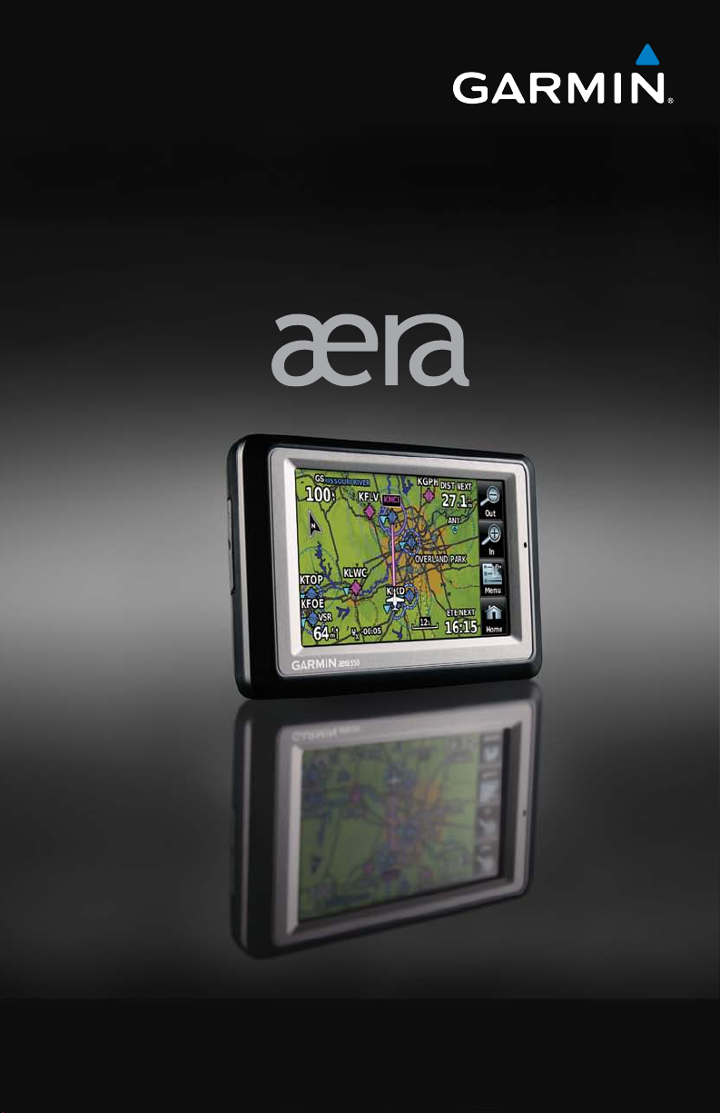
In aviation mode the aera presents GPS-derived analog flight instrumentation,
position, navigation, and hazard avoidance information to the pilot using a 4.3”
QWVGA color display with Touch Screen.
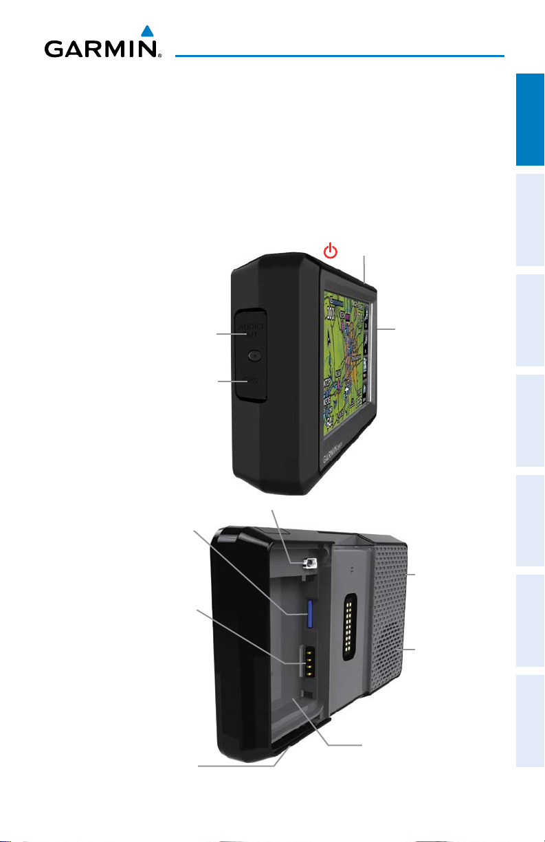
Power Button
Headphone/audio-out Jack
(Under Weather Cap)
External Antenna Connec-
tor (Under Weather Cap)
Microphone
Overview GPS Navigation Flight Planning Hazard Avoidance Additional Features Appendices Index
MicroSD™ Slot
Battery Contacts
Release Key: Slide and
Release to Open the Battery
190-01117-02 Rev. C
Cover
Mini-USB Connector
Serial Number (Under
the Battery)
Unit Overview
Garmin aera 500 Series Pilot’s Guide
GPS Antenna
Speaker
1
Overview
1.2 GETTING STARTED
OverviewGPS NavigationFlight PlanningHazard AvoidanceAdditional FeaturesAppendicesIndex
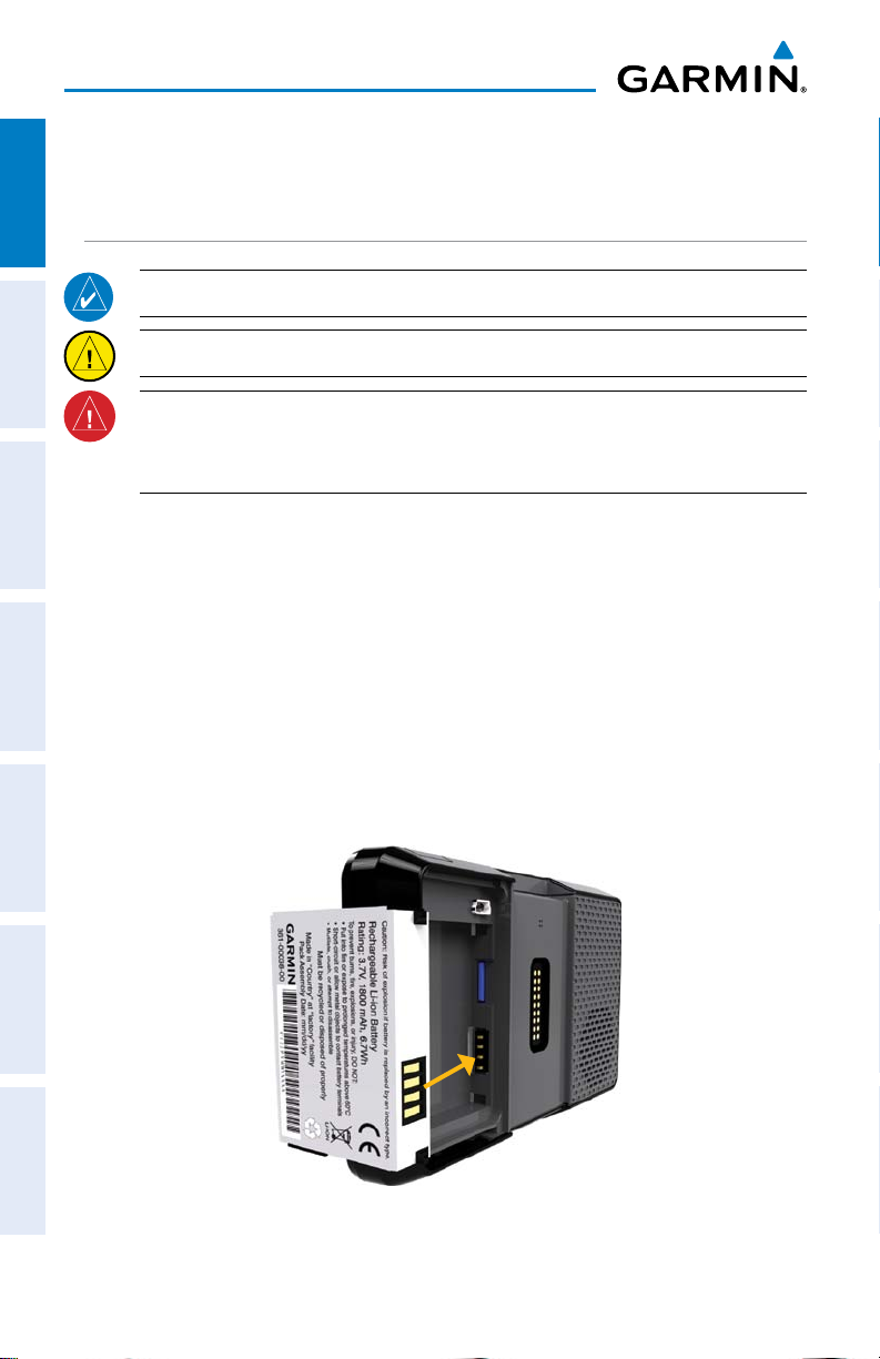
BATTERY INSTALLATION
NOTE: Refer to Appendix E for additional battery information.
CAUTION: Always keep the battery installed when the unit is on.
WARNING: The product contains a lithium-ion battery. To prevent damage,
remove the unit from the aircraft or vehicle when exiting or store it out of
direct sunlight.
Installing the battery:
1)
Locate the lithium-ion battery that came in the product box.
2)
Slide the release key until the battery cover on the back of the aera opens
up.
3)
Remove the battery cover.
4)
Locate the metal contacts on the end of the lithium-ion battery.
5)
Insert the battery so that the metal contacts on the battery line-up with the
metal contacts inside the battery compartment.
6)
Slide the top of the battery cover into the groove on the inside of the
battery compartment, and press down.
Installing the Battery
2
Garmin aera 500 Series Pilot’s Guide
190-01117-02 Rev. C

Overview
CHARGING THE BATTERY
NOTE: While in Charge Mode, the unit draws a current from the aircraft. To
avoid discharging the aircraft’s battery, disconnect the external power cable
from the unit when not in use for several days.
Charge the aera for at least 4 hours before using on battery power. Charge the
battery by connecting the vehicle or aviation power cable, the USB cable, an AC adapter
(optional accessory), or use a battery charger (optional accessory).
Plug the unit into a 12-Volt or 24-Volt connector to charge. The unit can be used
while it is charging. Charge the unit within the following temperature range
104°F (0° to 40°C).
Charging the unit’s battery using the aircraft's power outlet:
1)
Mount the aera in the aircraft (refer to Appendix D 'Installation and
Interfacing'), and connect the power cable to the aircraft power outlet
(cigarette lighter receptacle).
2)
Route the power cable so that it does not interfere with aircraft operation.
The unit begins charging as soon as external power is applied.
USING CHARGE MODE
: 32° to
Overview GPS Navigation Flight Planning Hazard Avoidance Additional Features Appendices Index
Applying external power to the aera automatically turns on the unit for full operation.
If the battery is present and needs to be charged, the external power source charges
the battery while the unit is in use.
If you do not want to use the unit, but you would like to charge the battery, you can
put the unit into Charge Mode. Connect the unit to an external power supply. Press
and hold the POWER Button. Instead of completely turning off, the unit now goes
into Charge Mode.
The unit will run cooler and may allow more current to be available while in Charge
Mode, when XM is unplugged, the backlight is turned down, etc.
MOUNTING THE aera IN THE AIRCRAFT
Refer to Appendix D 'Installation & Interfacing' for information on mounting the
aera in the aircraft.
190-01117-02 Rev. C
Garmin aera 500 Series Pilot’s Guide
3
Overview
TURNING THE UNIT ON/OFF
Press and hold the POWER Button to turn the unit on or off.
OverviewGPS NavigationFlight PlanningHazard AvoidanceAdditional FeaturesAppendicesIndex
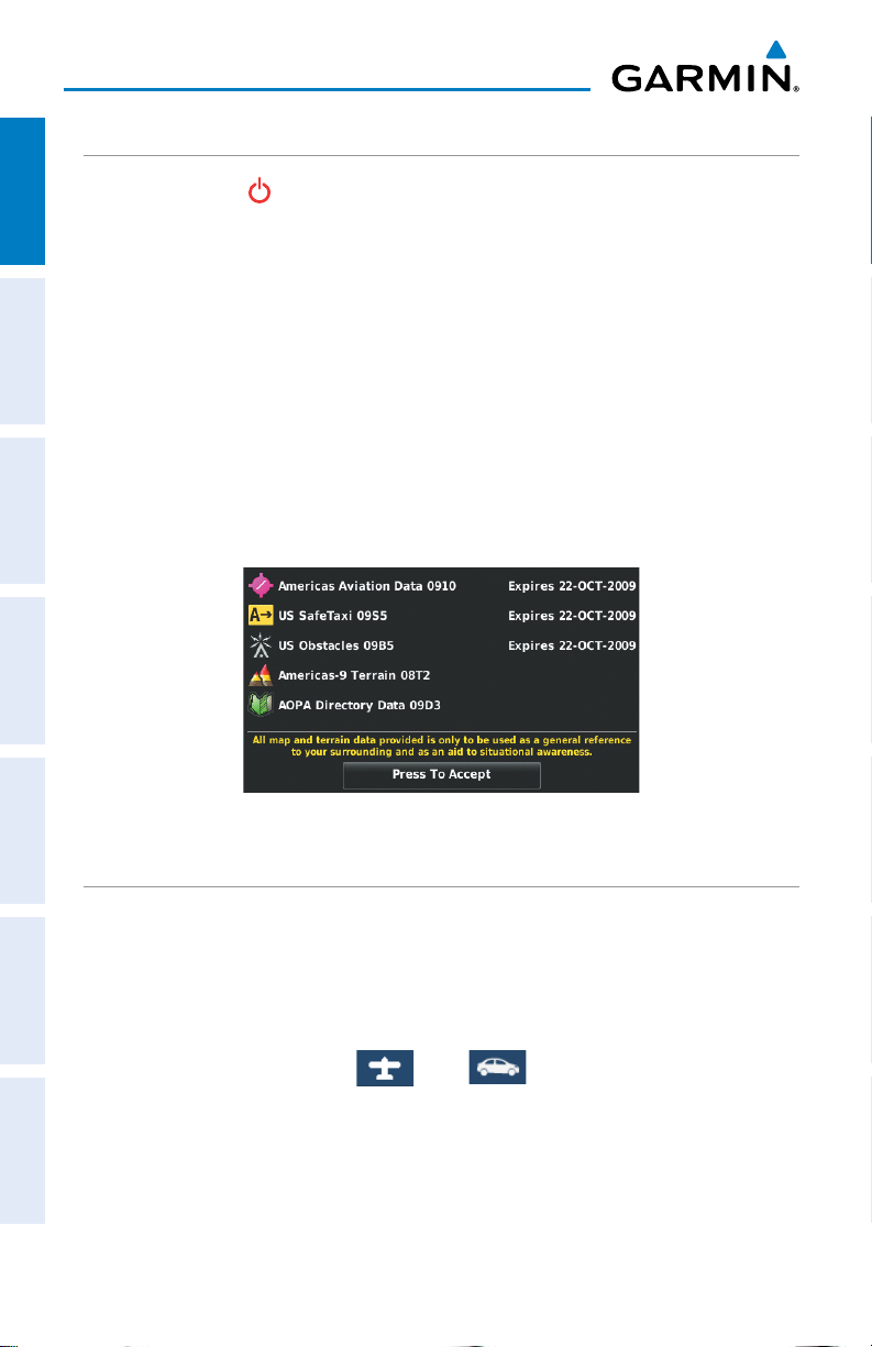
The first time the unit is turned on, the receiver must collect satellite data and
establish its present location. To ensure proper initialization, the aera is shipped from
the factory in AutoLocate mode, which allows the receiver to “find itself” anywhere in
the world.
During initialization, current database information is displayed. Database information
includes valid operating dates, cycle number, and database type. When this information
has been reviewed for currency (to ensure that no databases have expired), the pilot
is prompted to continue.
Touching the Press To Accept Button acknowledges this information, and the
'Home' Screen is displayed.
Database Initialization
CHANGING MODES
The aera offers two modes for transportation: automotive and aviation.
Changing modes:
1)
Touch the automotive or aviation icon at the top of the 'Home' Screen.
2)
Touch Yes.
AutomotiveAviation
Or:
1)
From the 'Home' Screen, touch Tools > Automotive or Aviation (from
automotive mode).
2)
Touch Yes.
4
Garmin aera 500 Series Pilot’s Guide
190-01117-02 Rev. C
Overview
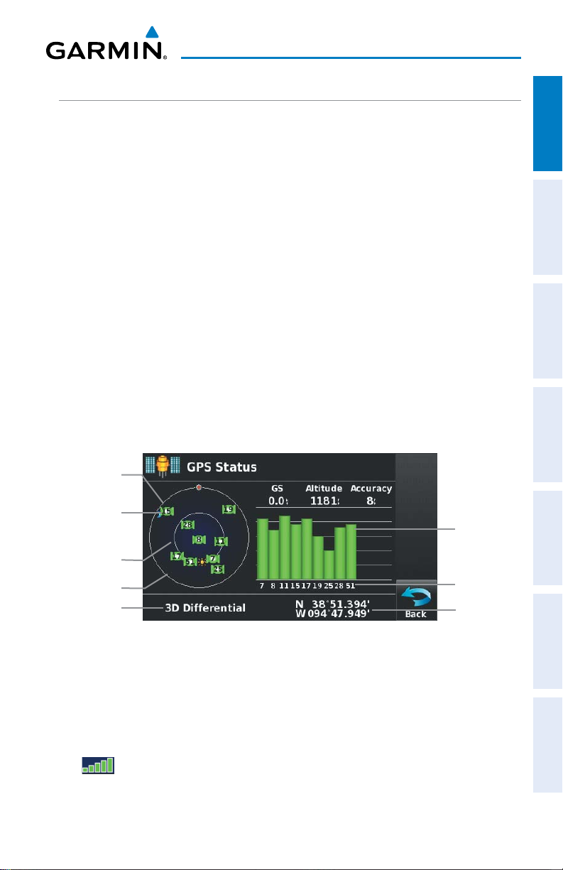
GPS RECEIVER STATUS
Overview GPS Navigation Flight Planning Hazard Avoidance Additional Features Appendices Index
The receiver status displays one of the following conditions:
•Autolocate—Receiver is looking for any satellite whose almanac has been
collected, which can take up to 5 minutes
•Searching the Sky—Receiver is looking for satellites
•Acquiring Satellites—Receiver is looking for and collecting data from satellites
visible at its last known or initialized location, but has not acquired a fix
•2D GPS Location—At least three satellites have been acquired and a two-
dimensional location fix has been calculated. “2D Differential” appears when
you are receiving DGPS corrections in 2D mode
•3D GPS Location—At least four satellites have been acquired and a three-
dimensional fix has been calculated. “3D Differential” appears when you are
receiving DGPS corrections in 3D mode
•Lost Satellite Reception—the receiver is no longer tracking enough satellites for a
2D or 3D fix
Constellation
Diagram
PRN Number
45° Above
Horizon
Horizon
Receiver Status
GPS Status
Viewing the GPS status:
From the 'Home' Screen, touch Tools > GPS Status.
ACQUIRING SATELLITES
The bars on the 'Home' Screen indicate the GPS signal strength.
190-01117-02 Rev. C
Garmin aera 500 Series Pilot’s Guide
Signal
Strength Bar
PRN Number
Location
(Lat/Long)
5

Overview
When the receiver is in the process of acquiring enough satellite signals for
navigation, the receiver uses satellite orbital data (collected continuously from the
satellites) and last known position to determine the satellites that should be in view.
OverviewGPS NavigationFlight PlanningHazard AvoidanceAdditional FeaturesAppendicesIndex
‘Acquiring Satellites’ is indicated as the solution until a sufficient number of satellites
have been acquired for computing a solution.
When the receiver is in the process of acquiring a 3D differential GPS solution, ‘3D
GPS Location’ is indicated as the solution until the 3D differential fix has finished
acquisition.
SATELLITE INFORMATION
Satellites currently in view are shown at their respective positions on a satellite
constellation diagram. The outer circle of the constellation diagram represents the
horizon, the inner circle represents 45° above the horizon, and the center point shows
the position directly overhead. Each satellite is represented by a square containing the
Pseudo-Random Noise (PRN) number (i.e., satellite identification number).
GPS Status can be helpful in troubleshooting weak (or missing) signal levels
due to poor satellite coverage or installation problems. As the GPS receiver locks
onto satellites, a signal strength bar is displayed for each satellite in view, with the
appropriate satellite PRN number (01-32 or 33-64 for WAAS) below each bar. The
progress of satellite acquisition is shown in three stages, as indicated by signal bar
appearance:
- No bar—Receiver is looking for the indicated satellite
- Gray bar—Receiver has collected the necessary data and the satellite signal can
be used
- Green bar—Satellite is being used for the GPS solution
6
Garmin aera 500 Series Pilot’s Guide
190-01117-02 Rev. C

Overview
1.3 OPERATION
BASIC NAVIGATION CONTROLS
The controls on the touchscreen change dynamically depending on the function
displayed.
Touch the following icons to perform the associated function:
Home Returns to the ‘Home’ screen.
Back Displays the previous page; Returns ‘Home’ (touch and hold).
OK Commits a value edited or selected.
Menu Displays the context sensitive option menu.
Menu/ Displays the menu; Displays the Direct-to function (touch and hold).
Up Scrolls up.
Down Scrolls down.
Direct-to Displays the Direct-to function.
Out Zooms out.
Overview GPS Navigation Flight Planning Hazard Avoidance Additional Features Appendices Index
In Zooms in.
KEYPAD CONTROLS
OK Exits the keypad function and accepts the changes.
BKSP Erases the current data.
Numeric Displays the numeric only keypad.
Alpha Displays the alpha and numeric keypads.
Cancel Cancels a value that has been edited.
190-01117-02 Rev. C
Garmin aera 500 Series Pilot’s Guide
7
Overview
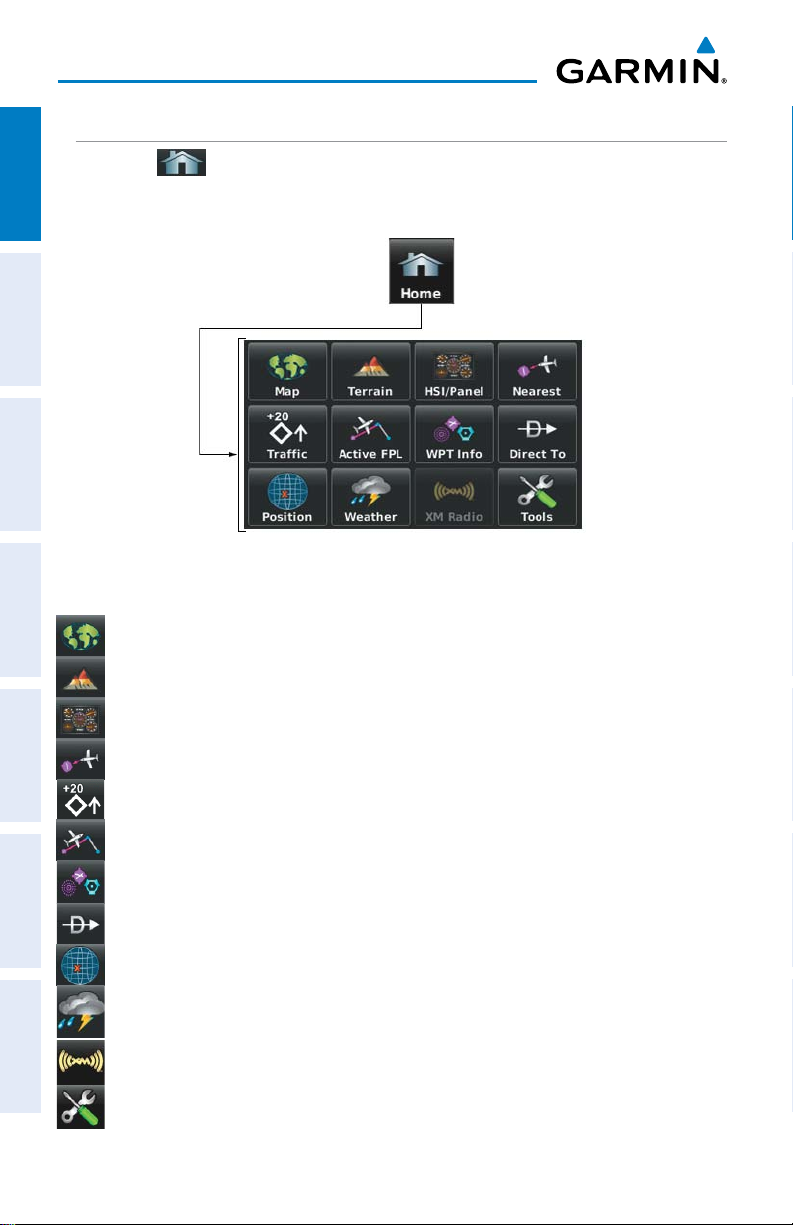
‘HOME’ SCREEN
Touch the
OverviewGPS NavigationFlight PlanningHazard AvoidanceAdditional FeaturesAppendicesIndex
icon at any time to access the ‘Home’ Screen.
‘HOME’ SCREEN ICONS
Touch the following icons to perform the associated function:
Map Displays the Navigation Map.
Terrain Displays the Terrain Map.
HSI/Panel Displays the Panel Mode.
Nearest Displays the second-level Nearest Icons.
Traffic Displays Traffic Page.
Active FPL Displays the Active Flight Plan.
WPT Info Displays the Waypoint Information.
Direct To Displays the 'Direct To' function.
Position Displays the aircraft's Present Position.
Weather Displays second-level Weather Icons (aera 510 & 560) or All models
with a GDL 39.
XM Radio Displays XM Radio (aera 510 & 560).
Tools Displays second-level Tools Icons.
8
Garmin aera 500 Series Pilot’s Guide
190-01117-02 Rev. C
Overview
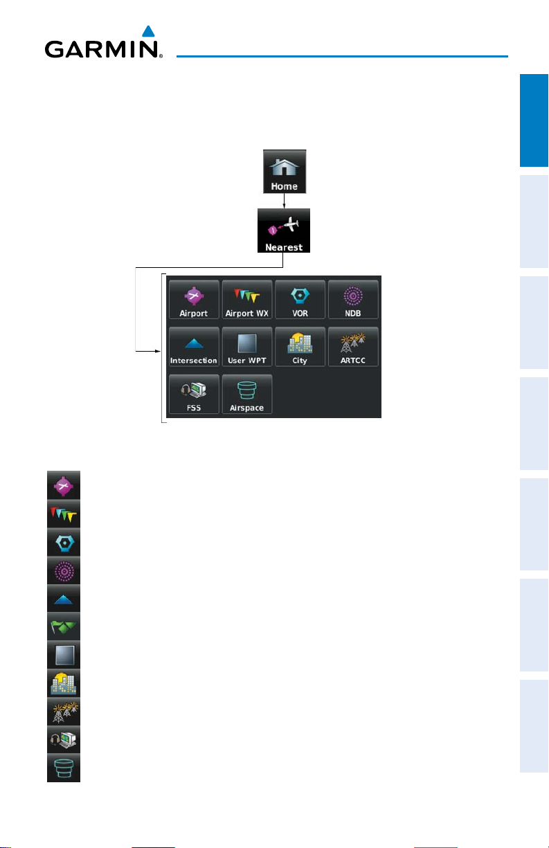
NEAREST ICONS
From the ‘Home‘ Screen, touch the Nearest Icon to access the second-level
Nearest Icons.
Touch the following icons to perform the associated function:
Airport Displays nearest airports.
Overview GPS Navigation Flight Planning Hazard Avoidance Additional Features Appendices Index
Airport WX Displays nearest airport weather.
VOR Displays nearest VORs.
NDB Displays nearest NDBs.
Intersection Displays nearest intersections.
VRP Displays nearest Visual Reporting Point (VRP) (Atlantic).
User WPT Displays nearest user waypoints.
City Displays nearest cities.
ARTCC Displays nearest ARTCCs.
FSS Displays nearest Flight Service Stations (FSS).
Airspace Displays nearest airspace.
190-01117-02 Rev. C
Garmin aera 500 Series Pilot’s Guide
9
Overview
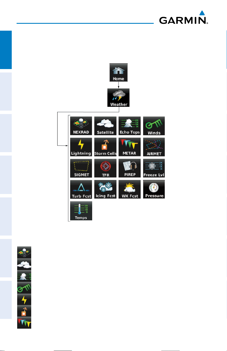
WEATHER ICONS (aera 510 & 560 XM) (ALL MODELS WITH A GDL 39)
From the ‘Home‘ Screen, touch the Weather Icon to access the second-level
OverviewGPS NavigationFlight PlanningHazard AvoidanceAdditional FeaturesAppendicesIndex
Weather Icons.
Touch the following second-level Weather Icons to display the weather product on
the Weather Map:
NEXRAD Displays NEXRAD (NEXt-generation RADar) (XM or GDL 39).
Satellite Displays Satellite Mosaic cloud cover (XM only).
Echo Tops Displays Echo Tops (XM only).
Winds Displays Winds Aloft. (XM or GDL 39).
Lightning Displays Lightning (XM only).
Storm Cells Displays Storm Cells (XM only).
METAR Displays METARs. (XM or GDL 39).
10
Garmin aera 500 Series Pilot’s Guide
190-01117-02 Rev. C

Overview
AIRMET Displays AIRMETs. (XM or GDL 39).
SIGMET Displays SIGMETs. (XM or GDL 39).
TFR Displays TFRs (XM or GDL 39).
PIREP Displays PIREPs. (XM or GDL 39).
Freeze Lvl Displays Freezing Levels (XM only)
Turb Fcst Displays the Turbulence Forecast (XM only)
Icing Fcst Displays the Icing Forecast (XM only)
WX Frst Displays Forecast Information (current, 12, 24, 36, & 48).
Pressure Displays Surface Pressure (XM only)
Temps Displays Temperatures Aloft (GDL 39 only).
Overview GPS Navigation Flight Planning Hazard Avoidance Additional Features Appendices Index
190-01117-02 Rev. C
Garmin aera 500 Series Pilot’s Guide
11
Overview
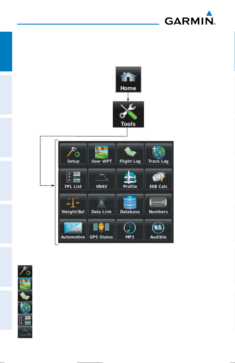
TOOLS
From the ‘Home‘ Screen, touch the Tools Icon to access the second-level Tools
OverviewGPS NavigationFlight PlanningHazard AvoidanceAdditional FeaturesAppendicesIndex
Icons.
Touch the following second-level icons to perform the associated function:
Setup Displays third-level Setup Icons.
User WPT Displays User Waypoints and Proximity Waypoints.
Flight Log Displays Flight Logs.
Track Log Displays Track Logs.
FPL List Displays the Flight Plan List.
VNAV Displays Vertical Navigation.
12
Garmin aera 500 Series Pilot’s Guide
190-01117-02 Rev. C

Overview
Profile Displays Aircraft Profiles.
E6B Calc Displays the E6B Calculator.
Weight/Bal Displays the Weight & Balance.
Data Link Displays Data Link Information.
Database Displays database and software version information.
Numbers Displays flight data. (Can be on the Home Screen depending on
options)
Automotive Activates automotive mode.
GPS Status Displays GPS status information.
MP3 Displays Music Player.
Audible Displays Audible Books.
Overview GPS Navigation Flight Planning Hazard Avoidance Additional Features Appendices Index
190-01117-02 Rev. C
Garmin aera 500 Series Pilot’s Guide
13
Overview
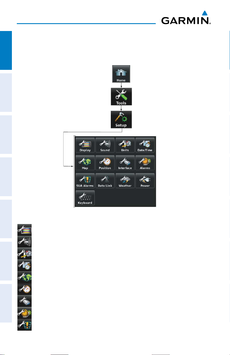
Setup IconS
From the ‘Home‘ Screen, touch the Tools > Setup to access the third-level Setup
OverviewGPS NavigationFlight PlanningHazard AvoidanceAdditional FeaturesAppendicesIndex
Icons.
Touch the following third-level icons to perform the associated function:
Display Displays backlight intensity/timeout and color mode settings.
Sound Displays sound settings.
Units Displays unit settings.
Date/Time Displays date & time settings.
Map Displays Navigation Map settings.
Position Displays position settings.
Interface Displays interface settings.
Alarms Displays alarm settings.
SUA Alarms Displays Special Use Airspace alarm settings.
14
Garmin aera 500 Series Pilot’s Guide
190-01117-02 Rev. C
 Loading...