

Page 1
."'
' .'
•
•.
LITHO IN USA.
•
•
•
988-0106-39A
•
•
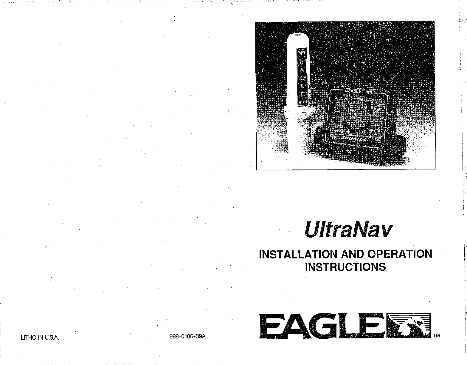
UltraNav
INSTALLATION
•
INSTRUCTIONS
EALGIflIE,tJt1
AND OPERATION
TM
PDF compression, OCR, web-optimization with CVISION's PdfCompressor
Page 2

NOTES:
PDF compression, OCR, web-optimization with CVISION's PdfCompressor
Page 3
s
I.
*V6i',L.r.
:::• :4I. :t:
:t?:.'.2.c
p . .,.• •1• .1 •
••...•t•Y••?. .
. — . . . .
.
NOTES:
SONAR TABLE OF CONTENTS
INTRODUCTION .
MOUNTING .
POWER CONNECTIONS
TRANSDUCER
KEYBOARD BASICS
DISPLAY
OPERATION
AUTOMATIC
SENSITIVITY
GRAYLINE
RANGE
ZOOM-AUTOMATIC
ZOOM-MANUAL
ALARMS
FISH ALARM
ZONE ALARM
DEPTH ALARM
AUDIO ALARM ON/OFF
MENUS
CHART SPEED
FISH
I.D
CHART CURSOR
FASTRAK
DIGITAL DISPLAYS
DIGITALSIZE
UNITOF MEASURE
BACKUGHTS
SPEAKER VOLUME
DISPLAY CONTRAST
DIGITAL SONAR
NOISE REJECTION
ASP
SURFACE CLARITY
DISPLAY ZONE BAR
DISPLAYZOOM BAR
TRANSDUCERS AND
SIGNAL INTERPRETATION
FISH ARCHES
WATER TEMPERATURE AND THERMOCLINES
SURVEYINGALAKE
CONTROL
CONE ANGLES
(SCC)
BAIT FISH
SONAR TROUBLESHOOTING
HOW TO OBTAIN SERVICE
LORAN SECTION
1
2
4
4
6
7
7
7
9
10
11
12
12
13
14
15
16
17
17
18
19
20
20
21
22
23
23
24
24
25
26
27
28
28
29
30
31
32
34
34
35
38
39
Copyright
All features and
©
1990, Eagle
All
rights
reserved.
specifications subject
Electronics
to
Change
without
notice.
AU screens in this manual are simulated.
PDF compression, OCR, web-optimization with CVISION's PdfCompressor
Page 4

NOTES:
PDF compression, OCR, web-optimization with CVISION's PdfCompressor
Page 5
•
.
.1 .1.
.".....—."""..
I
NOTES
INTRODUCTION
UltraNav
The
today.
performance.
at the touch of a button. The
tion
with
high
depth,
boat
(distance
is attached.
Although
menu
system
different features and functions
pressing
Read this manual and take it
unit. It makes a
know when
you!
represents
It rivals other sonar
With its
resolution and detail.
speed,
if the
log)
the UltraNav has
makes it
buttons!
great
you get
one
units
menus,
surface water
optional speed/temperature
many
to use. Above
easy
reference
to the
water,
of the best values in
costing
the UltraNav offers
The UltraNav also
temperature,
features and
on the unit. You can't hurt it
with
should
the
much more
screen shows the underwater
the first few times
you
you
more
your
sportfishing
in features and
easy-to-use
displays
and distance travelled
sensor
functions,
don't be afraid
all,
need it. The
UltraNav can do
digital
(model
the "soft
by
use
you
more
sonar
opera-
world
EST-T)
key"
to
try
your
you
for
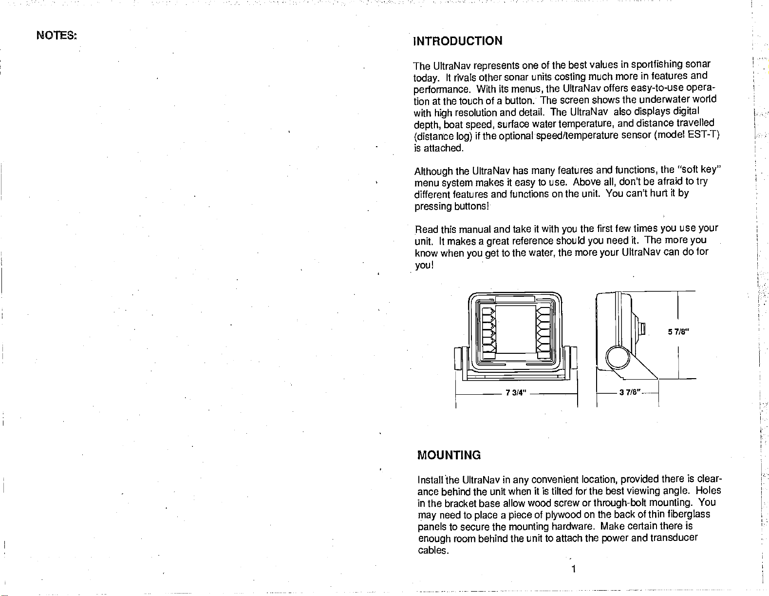
MOUNTING
in
Install The UltraNav
ance behind the unit when
in
the bracket base allow
need to
may
panels
enough
cables.
to secure the
room behind the unit
place
a
PDF compression, OCR, web-optimization with CVISION's PdfCompressor
convenient
any
it is
wood screw or
of
piece
mounting
plywood
to attach the
location,
for the best
tilted
on the back of thin
hardware. Make certain there is
1
provided
viewing angle.
through-bolt mounting.
and transducer
power
is clear-
there
fiberglass
Holes
You
Page 6
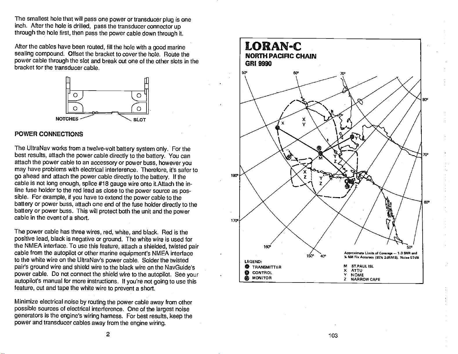
The smallest hole that will
inch. After the hole is
through
the hole
first,
drilled,
then
pass
pass
pass
one
power
or transducer
the transducer connector
the
power
cable down
plug
up
through
is one
it.
After the cables have
sealing compound.
power
bracket for the
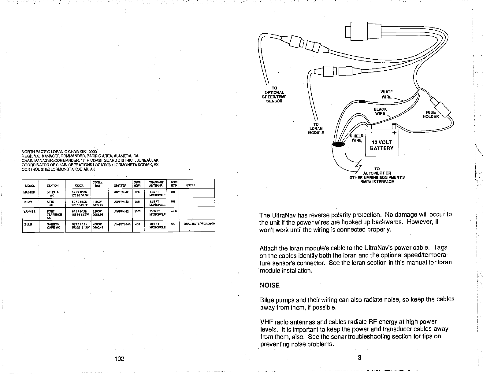
POWER
The UltraNav
best
attach the
may
go
cable
cable
through
transducer cable.
CONNECTIONS
works from a
results,
have
ahead and attach the
is
attach the
power
problems
not
long enough, splice
been
routed,
till the hole with a
Offset the bracket to cover the
the
slot and break out one of the other slots in
NOTCHES
twelve-volt
cable
power
cable to an
with electrical
power
accessory
directly
interference.
cable
directly
#18
gauge
line fuse holder to the red lead as close
sible. For
battery
battery
cable
or
or
in
the event of a short.
example,
power
power
if
have to
you
attach
buss,
one end of the fuse holder
buss. This will
extend the
protect
good
hole. Route the
battery system only.
to
the
battery.
or
power buss,
Therefore,
to the
however
battery.
wire onto it.Attach the in-
to the
power
power
source as
cable to the
directly
both
the unit and the
marine
the
For the
You can
you
it's safer to
lithe
pos-
to the
power
1 7Q°
The
power
positive
the NMEA interface. To use this
cable from the
to the white wire on the
pair's ground
power
autopilot's
feature,
Minimize electrical
possible
generators
power
cable has three
black is
lead,
autopilot
wire and
cable. Do
manual for more instructions. If
cut and
not connect the shield wire to the
tape
noise
sources of
is the
electrical interference. One of the
engine's
and transducer
wires, red,
negative
or
UltraNav's
shield wire to the black wire on the NavGuide's
or
feature,
other marine
the white wire to
by routing
harness. For best
wiring
cables
away
white,
ground.
equipment's
power
prevent
the
power
from the
2
and black. Red is the
The white wire is used for
attach a
cable. Solder the twisted
you're
shielded,
autopilot.
not
twisted
NMEA interface
See
to use this
going
a short.
cable
engine wiring.
from
away
largest
results,
other
noise
keep
pair
your
the
103
PDF compression, OCR, web-optimization with CVISION's PdfCompressor
Page 7
•
: •.
.
-.. .. .
•.
:fl. ..t?C".'
•: •. .
•. .
.
....
.
..
.
.
. . . .;
.
.. . .
. .. . .
.
. . .. .
I
NORTH
REONAL
CHAIN
COORDINATOR OF CHAIN OPERATIONS LOCATION: LORMONSTA KODIAK,
CONTROL SITE LORMONSTA
063I0. 61ATICI C#.
MISTER ST. PAIL
(RAY ATm
YANKEE
ZULU NARROW
LORAN-C CHAIN GR1 9990
PACIFIC
MANAGER COMMANDER. PACIFIC AREA.
MANAGER: COMMANDER. 17TH COAST GUARD DISTRICt
AK
KODIAK.
CBLL
Ac
Ac
PORT
CLARENCE
Ax
CAPE,AK
57 00122N
1701606,6W
524544.0/I
1737049.00
OS 1440311
1165312:6W
57262020
15222
11,3W
l0
3575.8
20000'
0066.05
-
43000/
3650.45
ia)
ALAMEDA,
XMTT
ISPPN12 225 625 Ft
AWPPN4S
AWPPN'42 1000 1360 Fr
AN'FPN'44A 400 625FT
CA
JUNEAU,
PVR
ThANS/MI
ANTENNA
KW)
355 S2SFT
AK
AK
MC*4OPOLE
MGIOPCLE
kflJCI'OLE
Ma4OPOLE
10.4
600 NOTES
0.0
0.0
*0.6
-
0.0 DUALRKIEW/ORI7900
OTHER MARINE
HMEA INTERFACE
The UltraNav has reverse
the
won't work until
unit
if the
power
the
polarity protection.
wires are hooked
is connected
wiring
Attach the loran module's cable to the
on
the cables
identify
ture sensor's connector.
both the loran and the
See the loran section
module installation.
NOISE
Bilge pumps
from
away
them,
and their
if
possible.
wiring
also radiate
can
VHF radio antennas and cables radiate
levels. It is
from
them,
preventing
important
also. See the sonar
noise
to
keep
problems.
the
power
troubleshooting
TO
AUTOPILOT
up
OR
EQUIPMENTS
No
damage
backwards.
However,
properly.
UltraNav's
power
cable.
optional speed/tempera-
in this manual for loran
so
noise,
AF
energy
and transducer cables
keep
at
high power
section for
will occur to
it
Tags
the cables
away
on
tips
PDF compression, OCR, web-optimization with CVISION's PdfCompressor
102
Page 8
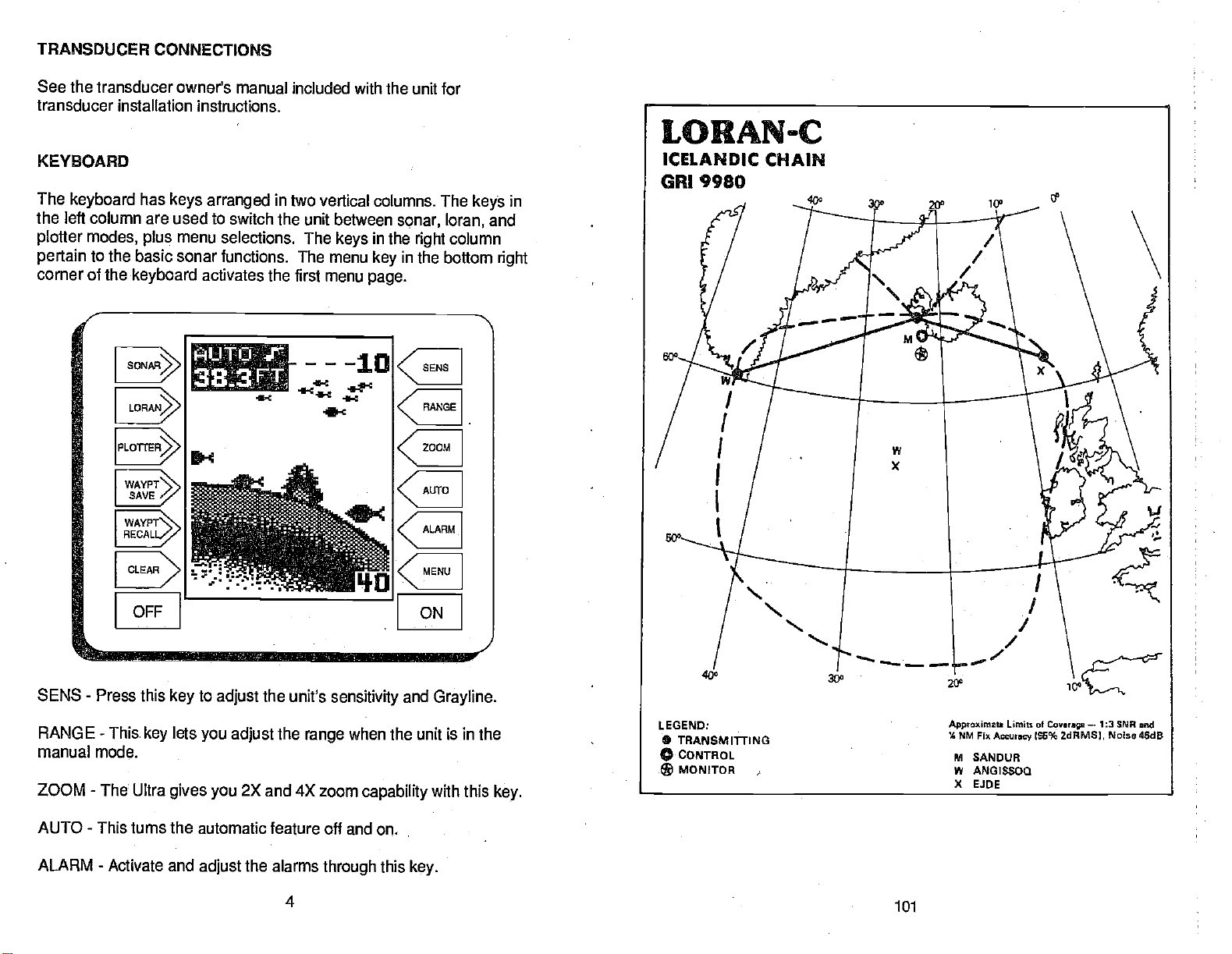
TRANSDUCER CONNECTIONS
See the transducer
transducer
KEYBOARD
The
keyboard
the
left column are used to switch the unit
plotter modes,
pertain
corner of the
installation instructions.
to the basic sonar functions. The menu
WAYPT
SAVE
WAYPT\
RECALL/
owner's manual
has
keys arranged
menu selections. The
plus
keyboard
activates the
333
FT
included with the unit for
in two vertical columns. The
between
keys
first menu
.1-c
4-c
sonar, loran,
in
the
right
in
key
page.
column
the bottom
ec
keys
and
right
in
OFF
SENS
RANGE - This
manual mode.
ZOOM
AUTO - This turns the automatic
ALARM - Activate and
-
Press this
-
The Ultra
key
lets
key
gives you
to
adjust
you
adjust
2X and 4X zoom
the
adjust
the unit's
the
feature off and on.
alarms
sensitivity
when the unit is in the
range
capability
through
4
this
ON
and
key.
Grayline.
with this
key
101
PDF compression, OCR, web-optimization with CVISION's PdfCompressor
Page 9
...:*•h... ( . ........'0 ........ ... .
.
. . 0. .... .0
.0 .....'
I
ICELANDIC LORAN-C CHAIN
REGIONAL MANAGER.
CHAIN MANAGER COMMANDER COAST GUARD ACTIVITIES EIJROPE. LONOON.
COORDINATOR OF CHAIN OPERATIONS LOCATION LORMONSTA KEFLAVLI(,
CONTRDLSITE:LORMONSTA
00010.
5645750 SANDUS
YWISKEY 4OlSSOO 5000 lION
XRAV E.100.MOROE 8217 E0$N
01M00/J ODOR.
0E.AND 035021.5W
GREENLAND 451527.5W
IS..DEESSAPX 270426.5W
GR1 9980
COMMANDER COAST GUARD ACTIVITIES
KEFLAVIK,
645426441
ICELAND
CD0LL
(uo)
11000'
4006.03
30600/
5544.54
xMrrrER
ANIFPS445
ANIFN445 760
M00IOPOLE
AWFPI'IAA
M0140P01.E
EUROPE. LONDON,UK
P5W
THANEMOT
ANTB406
IKV9
1506 l200Fr
M00IOPCLE
625FT 41.0
055
036 Fr 0.0 DLIAL0A1E
UK
ICELAND
-
N0/4
ECU NiftOs
0.0
DUALMTEW/0AI7030
0507570
-
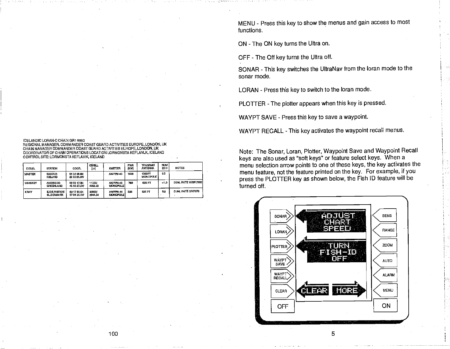
MENU
functions.
ON
OFF - The Off
SONAR
sonar
LORAN
PLOTTER
WAYPT SAVE
Press this
-
The ON
-
mode.
-
turns the Ultra
key
turns the Ultra
key
This
key
Press this
-
The
plotter appears
-
Press this
key
switches the
key
WAYPT RECALL - This
Note: The
keys
menu selection arrow
menu
press
Sonar, Loran,
are also used as 'soft
points
feature,
the PLOTTER
not the feature
key
turned off.
to show the
menus and
on.
off.
UltraNav from the
to switch to the
when
save a
to
key
activates the
key
Plotter,
Waypoint
or feature select
keys"
to one
printed
as shown
loran mode.
this
waypoint.
waypoint
of these
on the
below,
the Fish ID feature
gain
loran mode to the
is
key
pressed.
Save and
keys.
the
keys,
For
key.
access to
most
recall menus.
Waypoint
When a
activates the
key
example,
will be
Recall
if
you
AT
0I
FISH-ID
WAYPT
SAVE
WAY
PT"-.
RECALL"
OFFr
PDF compression, OCR, web-optimization with CVISION's PdfCompressor
100 5
'I
____
Hiji;:E-
CE
CE
CE
CE
CE
ON
Page 10
L15srr1
1ETRICI
j
4-C
0
•
LORANeC
NORTHWEST PACIFIC CHAIN
CR1 9970
AD.]'. DISPLAY
C
1 LIGHT
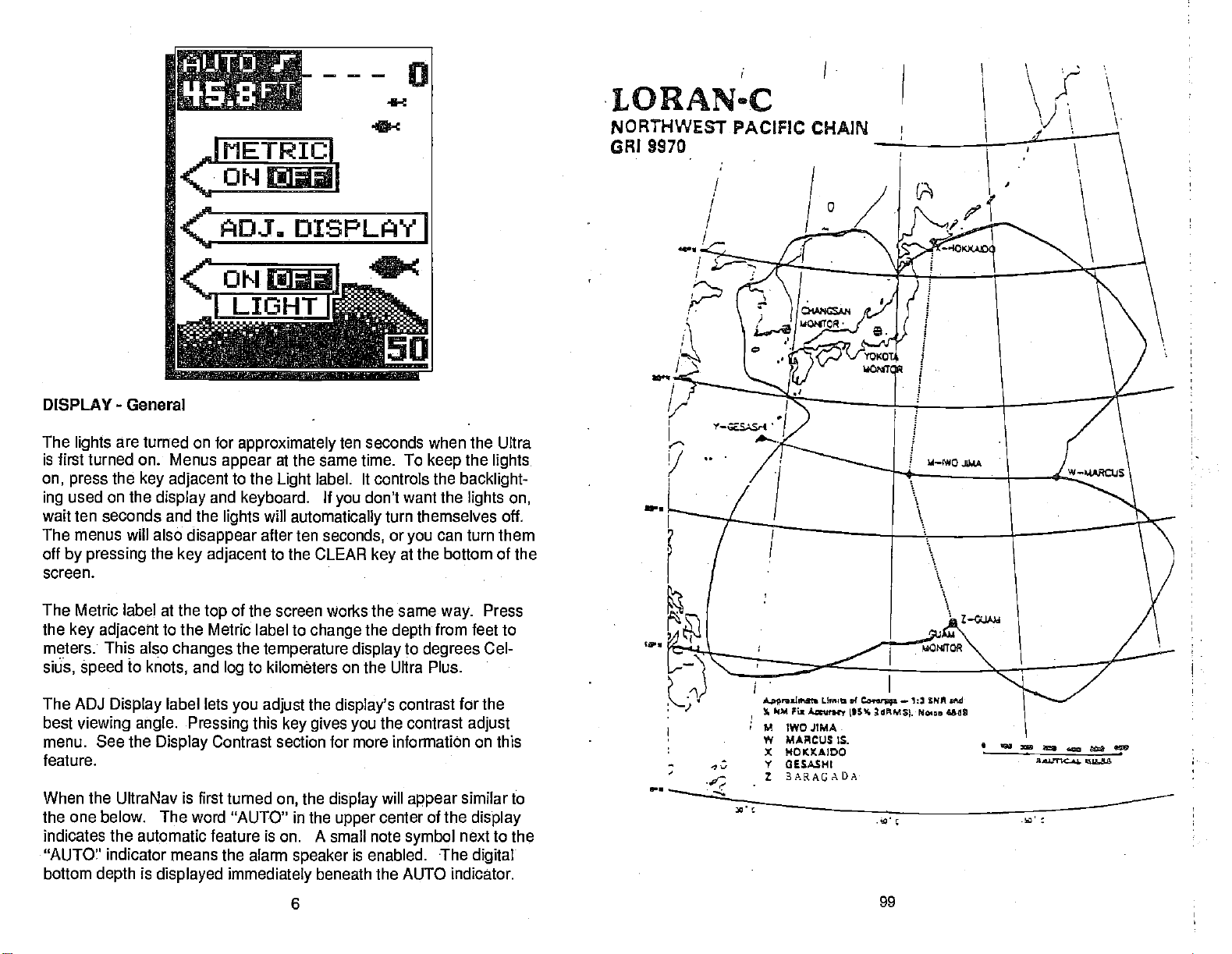
DISPLAY - General
The
is first turned on. Menus
on,
used on the
ing
wait ten seconds and the
The menus will also
off
by pressing
screen.
The Metric label at the
the
meters. This also
sitEs,
The ADJ
best
menu. See the
feature.
When the UltraNav is first turned
the one below. The word "AUTO" in the
indicates the automatic feature
"AUTO" indicator means the alarm
bottom
are turned on for
lights
appear
the
press
key adjacent
âpeed
viewing angle. Pressing
to
Display
depth
key adjacent
display
the
and
lights
disappear
key adjacent
top
to the Metric label to
changes
and
knots,
label lets
Display
is
displayed
log
Contrast section for more information on this
approximately
at the same time.
to the
keyboard.
will
after ten
label. It controls the
Light
automatically
to the CLEAR
of the screen works the same
change
the
temperature display
to kilometers on the Ultra Plus.
you adjust
this
immediately
the
key gives you
the
on,
is on.
A
speaker
beneath the AUTO
6
I
ten seconds when the Ultra
If
don't want the
you
seconds,
key
the
display's
display
upper
small note
is enabled. •The
I
To
turn themselves off.
or
you
at the bottom of the
depth
to
contrast for the
the contrast
will
appear
center of the
symbol
the
keep
can turn them
way.
from feet to
degrees
lights.
backlight-
lights on,
Press
Cel-
adjust
similar to
display
next to
digital
indicator.
the
S.
fl
Anr..j,tdl. LIrr .4
% (M Fiz
Aa,nny (*5% 2dMSL No.,.
M
IWO JIMA
W
MARCUS IS.
X
—
NOKKAIDO
Y GESASHI
1 3ARAGADA
Co.or.
;.
—
1: 5PM M
Ufl
-.
PDF compression, OCR, web-optimization with CVISION's PdfCompressor
Page 11
h . •. •4•R.. •.. .j.,pq.t.Ij.1..t5j..
ji5'i7q''.•n,?...
;....c
' .
.
I
NORTHWEST PACIFIC
REGIONAL MANAGERCOMMANDER. PACIFICAREA, ALAMEDA.CA.
CHAIN MANAGER COMMANDER,
COORDINATOR OF CHAIN OPERATIONS
CONTROL SITE LORMONSTA VOKOTA,
05510.
WSThR WOJIIM
WHISKEY MARCUS ISLAND
XMV HOI0II0O
YANKEE 0ESASMI
ZULU BARRISADA 132700.114 2535.04!
LORAN.C CHAIN CR1 9070
14TH COASTGUARD
STArI0!1 COOP.
JAPAN
JAPAN
JAPAN
JAPAN
244502.5W
141 1030,3E
241707.914
l036053.2E
424427.IN
1434300.20
2E 3025.014
1200550.45
144 4022,00 01000
LDCATION.
JAPAN
000LL
los)
110001
4253.90 AN01R4-45 • 2100
30005
0005.17
50000?
4403,29
DISTRICT,
COMMANDER,
XMITIEP
ANIFPN'.45 lOIS
A1WPPN.45
AN'FP*45
SWA
1KW)
500 025ff
600 625 Ft
HONDLULU, HI
FAR EAST
TRANSMIt N0!
ANTB'INA
1350 Ft '.0
M0!AOPOLO
1200ff
MCO4OPOLE
Ma4000LO
M4OLE
750 Ft
SECTION.
YOKOTA,
EGO NOTES
0.0
0.0 DUALAATEw!oRI5070
DUAL RATE WIOPISS7O
0.0
JAPAN
SONAR
OPERATION
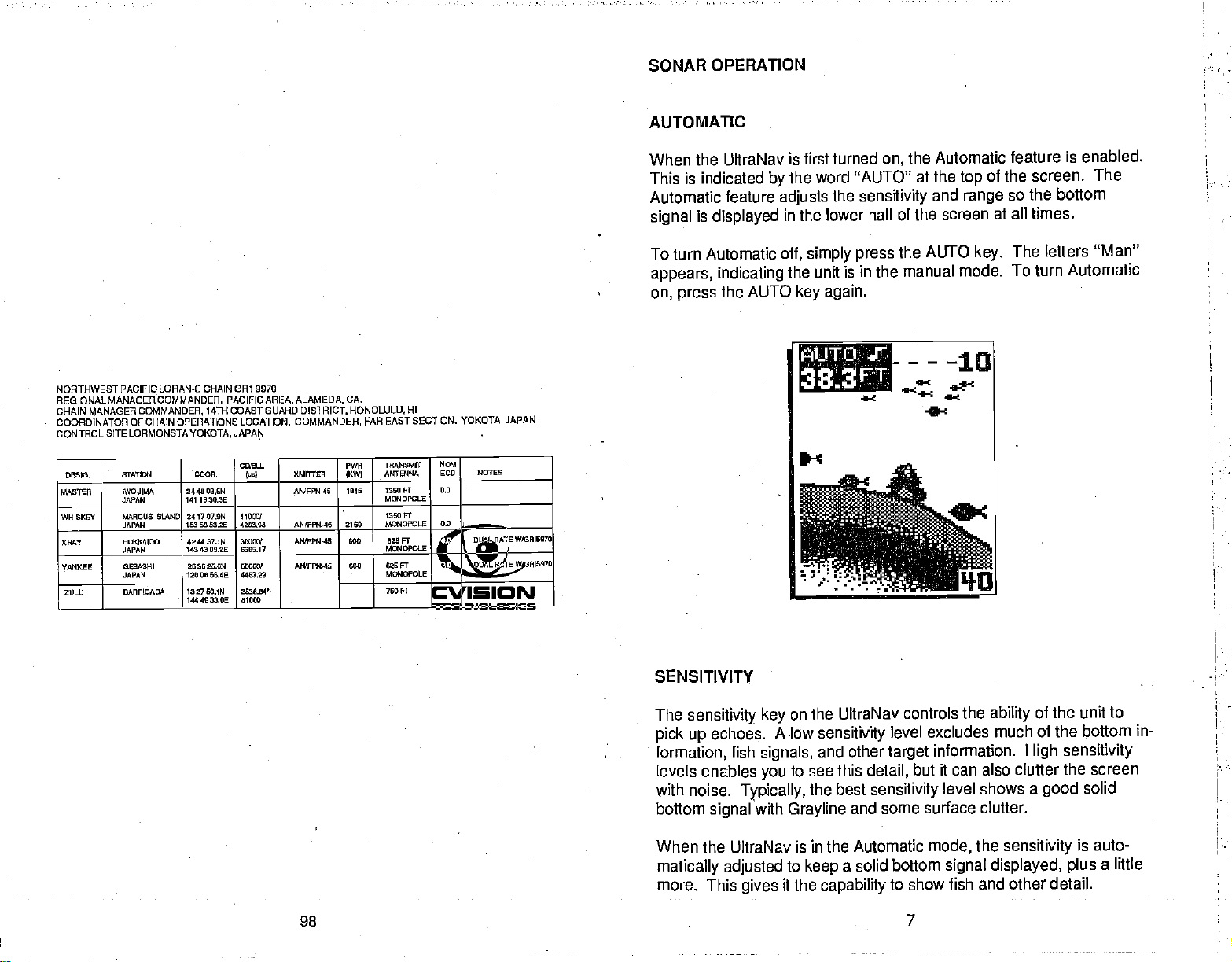
AUTOMATIC
When the UltraNav is
This is indicated
Automatic feature
is
signal
displayed
To turn Automatic
appears, indicating
on, press
the AUTO
the
by
adjusts
in the lower half of the screen
off, simply press
the unit
first turned
the Automatic feature
on,
word "AUTO" at the
the
sensitivity
the AUTO
is in the manual mode.
again.
key
iiUTrP..
3$3FT
----10
.
4_5
and
a
—
of the
top
range
at all times.
key.
is enabled.
screen. The
so the bottom
The left ers "Man"
To turn
Automatic
SENSITIVITY
The
sensitivity
pick up
formation,
echoes.
fish
levels enables
with
noise.
bottom
When
Typically,
signal
the UltraNav is
matically adjusted
more. This
PDF compression, OCR, web-optimization with CVISION's PdfCompressor
98 7
key
signals,
you
with
gives
on the UltraNav controls the
A low
sensitivity
and other
to see this
the best
Grayline
in the Automatic
to
it the
a solid
keep
capability
level excludes
information.
target
detail,
sensitivity
it can also clutter the screen
but
level shows
and some surface clutter.
mode,
bottom
signal displayed, plus
to show fish and other detail.
the
of the unit to
ability
much of the bottom in-
High sensitivity
a
sensitivity
good
solid
is auto-
a little
Page 12
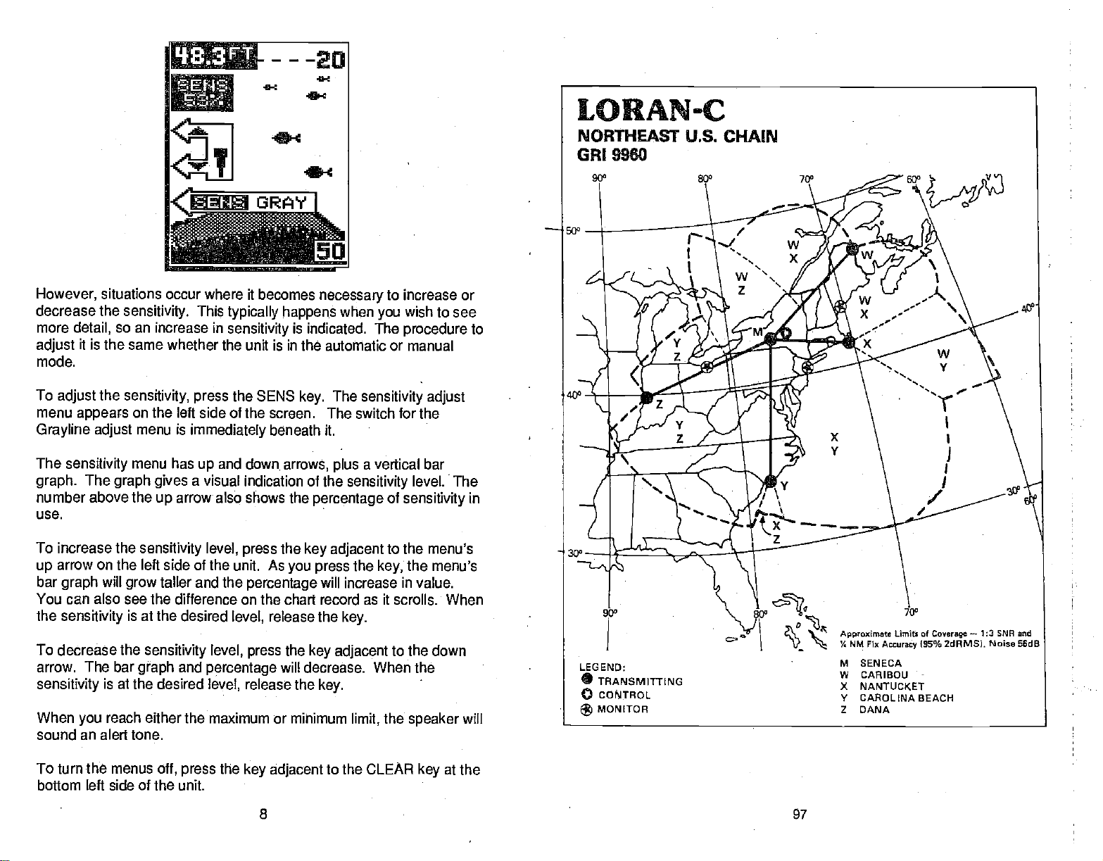
t}33FT
113RAY1
'---ED
However,
decrease the
more
adjust
mode.
To
adjust
menu
Grayline adjust
The
graph.
number above the
use.
To increase the
arrow on the left side of the unit. As
up
bar
You can also see the difference on the
the
To decrease the
arrow. The bar
sensitivity
situations occur
detail,
so an increase in
it is the same
the
appears
sensitivity
The
graph gives
will
graph
sensitivity
is at the desired
where it becomes
sensitivity.
sensitivity, press
on the
menu is
menu has
This
typically happens
sensitivity
whether the unit is in the automatic or manual
the SENIS
left side of the screen. The switch for the
immediately
and
up
a visual indication of the
arrow' also shows the
up
sensitivity
taller and the
grow
is at the desired
sensitivity level, press
graph
level,
and
percentage
level,
level,
beneath it.
down,
press
percentage
release the
release the
necessary
when
is indicated. The
The
key.
arrows, plus
percentage
the
key adjacent
you press
will increase in value.
chart record as it scrolls. When
key.
the
key adjacent
will
decrease.
key.
to increase or
wish to see
you
procedure
sensitivity adjust
vertical bar
a
sensitivity
level. The
of
sensitivity
to the menu's
the
the menu's
key;
to the down
When
the
to
in
When
sound an alert tone.
To turn the menus
bottom left side of the unit.
reach either the
you
off,
maximum or minimum
the
press
key adjacent
8
the
limit,
to the CLEAR
'
speaker
at the
key
will
'
97
PDF compression, OCR, web-optimization with CVISION's PdfCompressor
Page 13
GRAYLINP
NORTHEAST U.S. LORAN-c CHAIN GRI 9960
REGIONAL MANAGERCOMMANOER, ATLANTICAREA.
MANAGER
CHAIN
COORDINATOR OF cHAIN OPERATIONS LOCATION: LORSTA SENECA,
CONTROL SITE: LORSTA SENECA,
D®I0. &TA'TI4 OWE,.
MASTER 860400A,2W
WHISKEY OARBOU,
XHAY NAI'IlJOKET
YANKEE CARaWA
fltU
COMMANDER,
MA
000
DEAtH.
DANAIN
ATLANTIC
NY
4242 SOON
764023.9W
OdE 40402724
075637.7W
411011204
606030.1W
3403 lOIN
779446,7W
3951 07.014
-
07201MW
AREA,
ODELL
(601
1100W
270720
200'
1900.51
3000)!
3221.04
6409W ANdFFN'44
3162.60
NEWYORK,NY
NEWYORK, NY
9WUER
AJ2FH4-94
(50(10001
NdVFR.I.12
ANdrFI1.12
AWFPN-42 TIP
PWR
((WI
000 700 Fr
360 OLT 0.0 DUAL HATE
325
050
400
NY
'17W.040MIT
AI4TENKA
MaIDPOLE
620 FT
MWDPOLE
625Fr
Ma4DPOLE
NW,I
6W NOTES
0.0 DUAL HATE W/0R5070
WIOREISO
0.0
DUAL RATEWFSW003O
DUAL HATE W!0Rh7960
0.0
20 DLJALHATEW(0010970
-
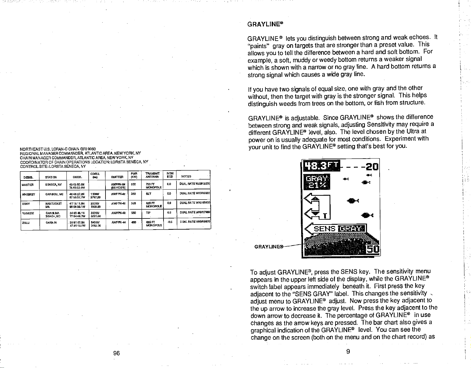
GRAYLINE® lets
"paints"
allows
example,
gray
you
to
a
you
on
targets
tell the difference between
soft, muddy
which is shown with a
causes a wide
strong signal
If
have two
you
without,
distinguish
GRAYLINE® is
between
which
signals
then the
target
weeds from trees
adjustable.
strong
and weak
different GRAYLINE®
on is
power
unit to find the
your
usually adequate
GRAYLINE®
distinguish
that are
or
stronger
weedy
narrow or no
of
with
equal
gray
size,
is the
on the
Since GRAYLINE®
signals, adjusting
also. The level
level,
for most conditions.
setting
q3jFT
a
'r
between
strong
than a
a hard and soft bottom.
bottom
returns a weaker
line.
gray
line.
gray
with
one
stronger signal.
bottom,
that's best for
---20
4-c
Sc
and weak
preset
value. This
signal
A hard bottom
and the other
gray
This
from structure.
or fish
shows the difference
Sensitivity may
chosen
the Ultra
by
Experiment
you.
echoes. It
For
returns a
helps
require
a
at
with
GRAYLINE®—
To
appears
switch label
adjacent
adjust
the
GRAYLINE®,
adjust
in the
appears
to the "SENS GRAY"
menu to GRAYLINE®
arrow to increase the
up
down arrow to decrease it. The
changes
graphical
change
PDF compression, OCR, web-optimization with CVISION's PdfCompressor
96
as the arrow
indication of the GRAYLINE®
on the screen
r
upper
the SENS
press
side of the
left
immediately
label. This
adjust.
gray
are
keys
(both
pressed.
on the
The
key.
display,
beneath it. First
sensitivity
while the GRAYLINE®
press
changes
Now
level. Press the
percentage
the
press
key adjacent
of GRAYLINE®
The bar chart also
level. You can see the
menu and on the chart
9
the
sensitivity
adjacent
key
menu
the
key
in use
gives
record)
to
to the
a
as
Page 14
you
press
adjacent
the
keys.
After
to the CLEAR
you've
to erase the
key
made the
menu.
adjustment, press
the
key
RANGE
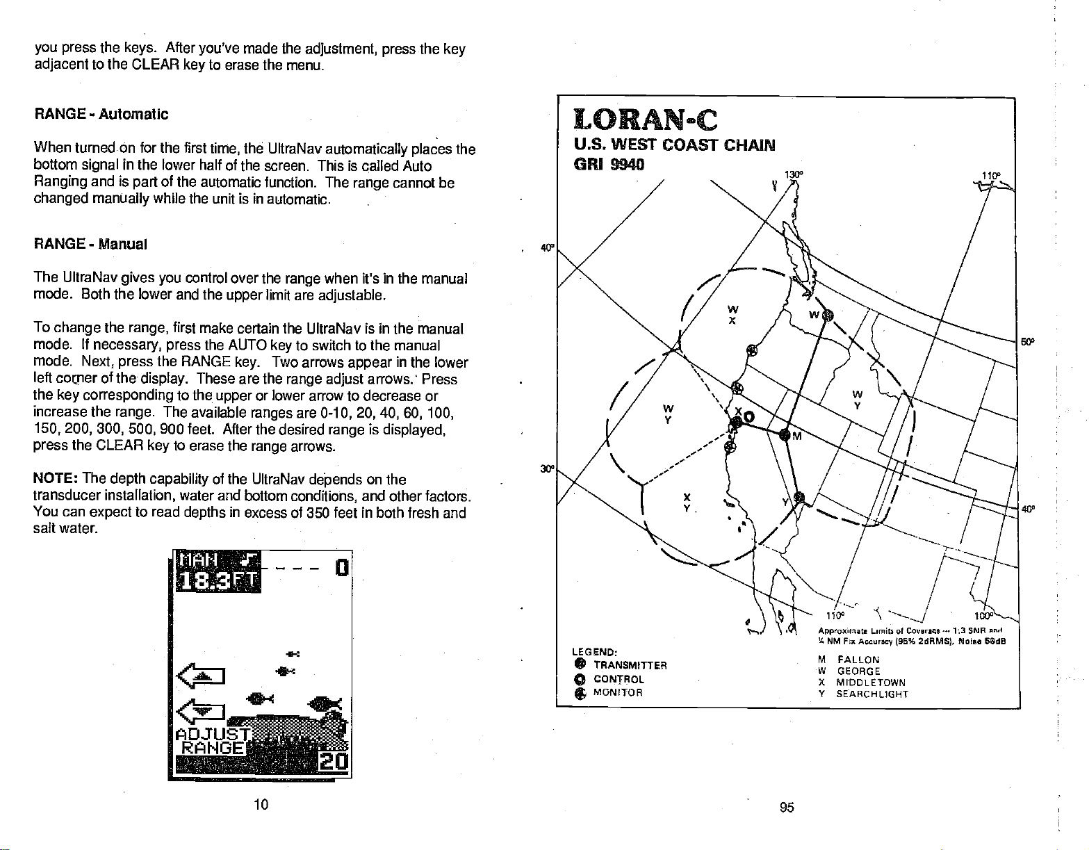
When turned On for the first
bottom
Ranging
changed manually
RANGE - Manual
The UltraNav
mode. Both the lower and
To
mode. If
mode.
left
the
increase the
150,200,300, 500,
press
NOTE:
transducer
You can
-
Automatic
signal
and is
change
corper
key
the
necessary, press
Next,
of
corresponding
range.
the
CLEAR
The
depth capability
installation,
expect
in the tower half of
of the
part
while the unit is in automatic.
gives you
range,
press
the
display.
control over the
first make certain the UltraNav is in the manual
the
RANGE
These are the
to the
The available
900 feet. After the desired
to erase the
key
water and bottom
to read
depths
salt water.
the UltraNav
time,
automatically places
the screen. This is called Auto
automatic function. The
range
the
the AUTO
upper
of the UltraNav
limit are
upper
to switch to the manual
key
Two arrows
key.
range adjust
or lower arrow to decrease or
ranges
range
in excess of 350 feet in both fresh
are
arrows.
dej.ends
conditions,
range
when it's in the manual
adjustable.
appear
arrows: Press
0-10, 20, 40, 60, 100,
is
range
on the
and other factors.
the
cannot be
40'
50'
in the lower
displayed,
and
tilt
:l1
0
18..3FT
t
ADJUE
RiiNG'
10
PDF compression, OCR, web-optimization with CVISION's PdfCompressor
S
jcU
95
Page 15
ZOOM
U.S. WEST COAST LORAN-c CHAIN CR1 9940
REGIONAL MANAGER COMMANDER.
CHAIN MANAGER COMMANDER. PACIFIC AREA, ALN'IEDA, CA
COORDINATOR OF CHAIN OPERATIONS LOCATION LORSTA MIODLETOWN,
CONTROL
SITE: LORSTA
DEmo. STMIOI ODOR. In) XMVITSR
MASTER FAlLOW, NV
WHISKCY eEOAflWA
XItAY
VMIcEE
MIDDLETOWI
CA-
SEARCHLIGHT
NV-
MIODLETOWN,CA
PACIFIC
3633 06.6N
11545 564W
4703-WON
11944395W
204657.ON
1r2944.5W
3919162W 40003/
l4 4617-4W 196730
11003/
3766.66
27000/
105430
AREA, ALAMEDA,
AWFPN-4M 400 625 FT
.
AN'FFfI-IS
MI67PN44A 100
MONOPOLE
AIEFFW44 540
CA
PWR
1KW)
1600 OtT
7NSM6T
.ANrslIa
MOIOPOLE
625F1
OLT 0.0
CA
601
SOD NOTES -
+19
+0.5 DUALPATEW/0flI6960
+0-6
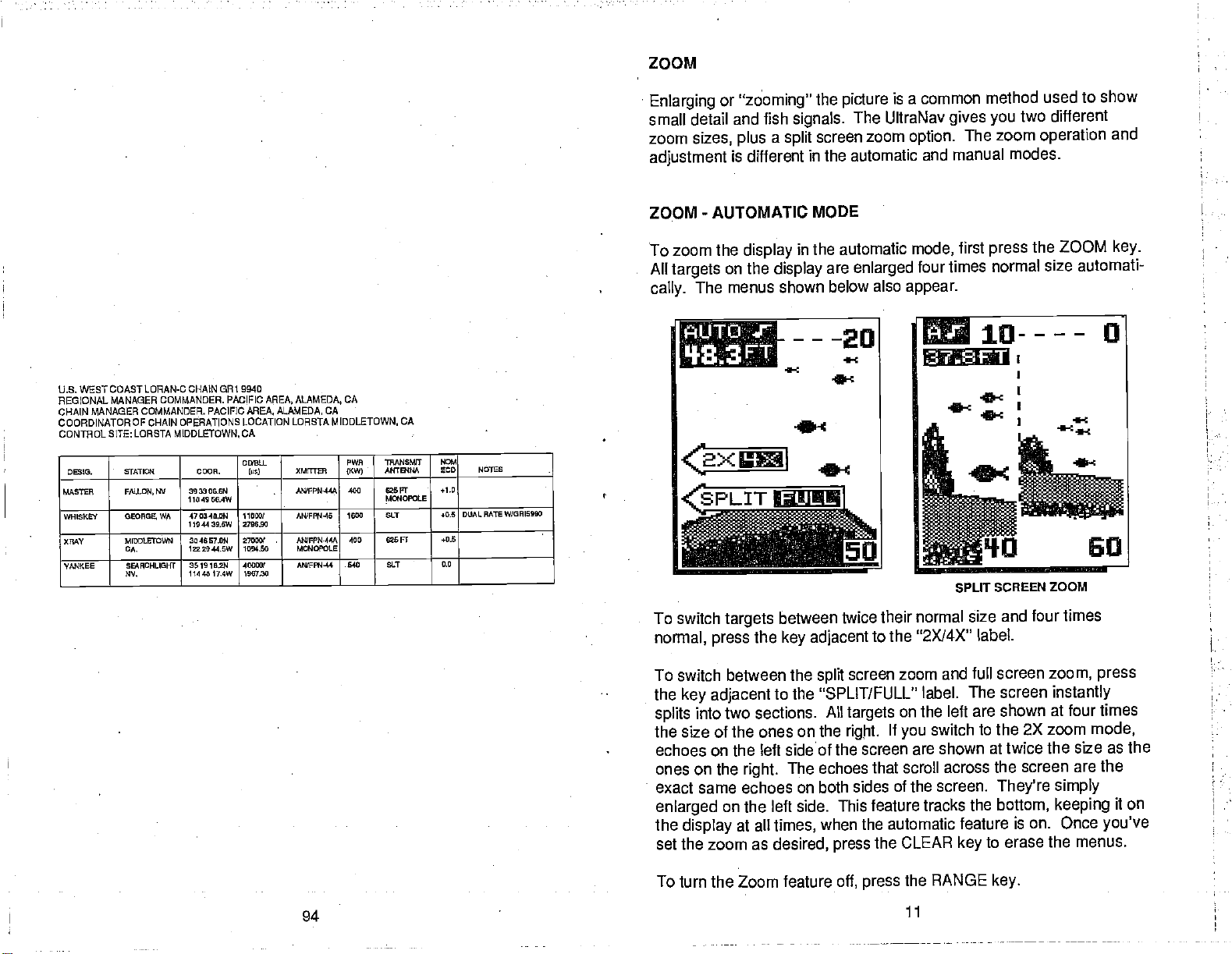
Enlarging
or
"zooming"
small detail and fish
zoom
sizes,
adjustment
ZOOM
-
AUTOMATIC
To zoom the
All
targets
The menus shown below
cally.
a
plus
is different
display
on the
display
----20
I}SE3FT
the
signals.
screen zoom
split
picture
isa common
The UltraNav
option.
gives
in the automatic and manual
MODE
in the automatic
are
enlarged
also
mode,
four times
appear.
3?,&FT
0:
method used to show
two different
you
The zoom
operation
modes.
first
press
the ZOOM
normal size automati-
SPUT SCREEN ZOOM
and
key.
To switch
normal,
press
targets
between
the
key
To switch between the
the
splits
the
adjacent
key
into two sections. All
of the ones on the
size
echoes on the
ones on the
exact same echoes on both sides of the
enlarged
the
on the
display
set the zoom as
To turn the Zoom feature
PDF compression, OCR, web-optimization with CVISION's PdfCompressor
94
to the "SPLIT/FULL" label.
left sideof the screen
The echoes that
right.
left side. This feature
at all
times,
desired,
twice their normal size
adjacent
spill
to the "2X14X"
screen
targets
rigjit.
zoom and full screen
on
If
you
are shown at twice the
scroll across the screen are
the left are shown at four times
switch to the 2X zoom
tracks the
when the automatic
the CLEAR
press
press
the RANGE
11
off,
screen.
and four times
label.
zoom, press
The screen
instantly
mode,
size as the
They're simply
bottom,
keeping
feature is on. Once
to erase the menus.
key
key.
the
it on
you've
Page 16
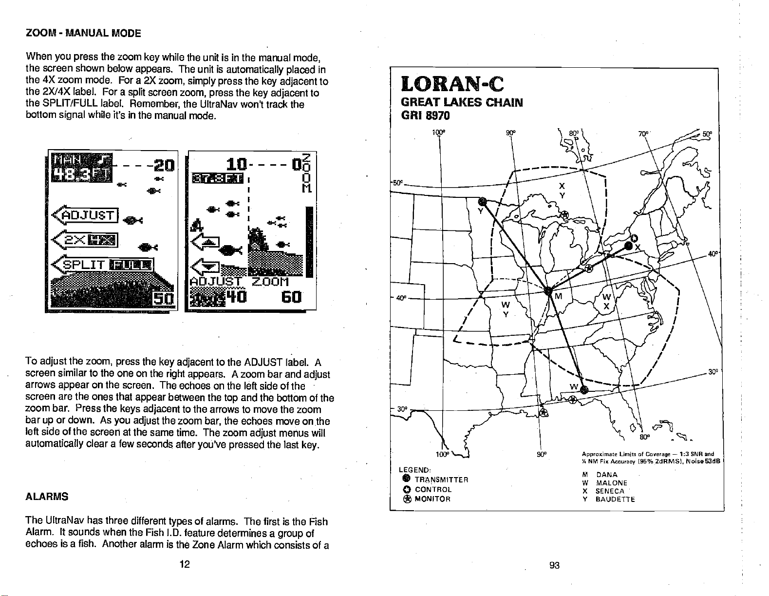
ZOOM - MANUAL MODE
When
you press
the screen shown below
the 4X zoom
the 2X/4X
the SPLIT/FULL
bottom
signal
the zoom
mode. For a 2X
label. For a
label.
while
it's in the manual mode.
----20
B
'f
4OJUST
cc
I
<2XI
white
key
appears.
zoom,
screen
split
Remember,
the unit is in the manual
The unit is
simply press
zoom, press
the UltraNav won't track the
automatically placed
the
key adjacent
the
key adjacent
1g----D
ec
ADJUST ZOOM
mode,
in
to
to
To
screen similar to the one on
arrows
screen are the ones that
zoom bar. Press the
bar
left side of the screen
automatically
ALARMS
The UltraNav has three
Alarm. It sounds when
echoes is a fish.
the
adjust
appear
or down. As
up
zoom,
on the
clear a few
Another alarm is the Zone
the
press
screen. The echoes on the left side of
keys
you
at the same time.
the Fish l.D. feature determines a
key adjacent
the
appear
adjacent
adjust
seconds
different
right appears.
between the
the zoom
after
types
12
to the ADJUST label. A
A zoom bar and
and the bottom of the
top
to the arrows to move the zoom
the
bar,
The zoom
you've pressed
echoes move on .the
adjust
the last
of alarms. The first is the
Alarm which consists of a
adjust
the
menus wilt
key.
Fish
of
group
93
PDF compression, OCR, web-optimization with CVISION's PdfCompressor
Page 17
SELECT
ALARM
OF
TYPE
ALARM MENU
GREAT LAKES
REGIONALMANAGER
CHAIN MANAGER COMMANDERATLANTICAREA, NEWYORK,
COORDINATOR OF CHAIN OPERATIONS LOCATION: LORSTASENECA.
CONTROLSITE:LORSTASENECAMY
D6210. s1WTIi
WETER DAkk, 91 206! 0791
WHISKEY MA1.040. ft
XMY EBIECA,
YANKEE
LORAN-C CHAIN CR1 897D
COMMANDER,
OAUOETTS
-
ATLANTICAREA, NEWYORK.
009
0720121W
300030.704
0510 203W
424200.0W
764932.0W
4020 4091 440004 ANIPFII-42
NY
-
OD'OU P990 TWANEEST
lYE)
110001
3390.11
20000!
6162.06
NY
XMUTEII
AIQFPN-44 4
ANIFPN-64 600
AWFW4-64 000
6KW)
HOSE)
HOGS)
600 730 Fl 00
-
NY
N4
flhTB*
626 Ft
MGIOPOIE
700ff
MGIOPOLE
700 Fl 0.0 DUAL BATE
M0!IOPLE
ECD NOTES
0.0 OOJAL BATE 000910900
0.0 DIJALRMEW!09I7060
W!G919060
bar.
Any
echo that
appears
alarm is called the Bottom
alarm. This is useful as
inside this bar
Alarm.
an anchor
navigation.
You can also turn
ALARM
FISH
the alarm
speaker
Use the fish alarm for a distinctive
suspended objects
fish alarm
adjacent
feature,
to the
are detected
first
press
the
'FISH" label- The menu
triggers
bottom
the
Only
watch,
audible alarm when
by
ALARM
a shallow water
off
through
the Fish LD.
Now
key.
shown below
the ALARM menu.
feature- To use the
the alarm.
will
signal
alert,
fish or other
the
press
appears.
The last
this
trip"
or for
key
PDF compression, OCR, web-optimization with CVISION's PdfCompressor
92
13
Page 18

To
turn the fish alarm
label. The screen will clear and return to the chart
fish
a
symbol displays
"FISH" shows
when the alarm sounds.
in
on, press
on
the lower left corner of the screen.
the
the
screen,
key adjacent
to the "TURN ON"
a tone will sound. The word
display.
They
Each time
will flash
To turn the
adjacent
"TURN OFF" label. The
ZONE ALARM
To activate the
the
key
show
The
adjustment
the zone bar shows on the
between the
alarm will sound on
fish alarm
to the "FISH" label. Now
next to the Zone Alarm
on the screen's
top
of
f, again
alarm is now disabled.
Zone.Alarm,
right side,
label
appears
and bottom of this
fish, structure,
'}83FT
çSHAL
the ALARM
press
the
press
first
press
label. The word s "ZONE ALARM"
signifying
on the loft side of the
far
right
side.
bar
bottom
key adjacent
the ALARM
the Zone Alarm is active.
echo that
Any
will
trigger
echoes,
•IkflZ
-
—ctJo
then the
key,
tb the
Next,
key.
display,
appears
the alarm. This
etc.
cN
E
A
L
ISETI
_____
F!J1I
A
R
key
400
press
whereas
300
5D
To
SET SHAL/DEEP label. The SHAL
press
shallower. To
to the down arrow. To
press
adjust
up
PDF compression, OCR, web-optimization with CVISION's PdfCompressor
the
adjust
the
key adajacent
the
key adjacent
the bottom of the zone alarm bar
and down arrows.
of the zone
top
adjust
alarm
to the
top
the
of the bar
top
the bottom of the zone alarm
adjust
to the SET SHALJDEEP label. You can now
first
bar,
letters
arrow to
deeper,
using
14
the
press
appear
move the
in reverse. Now
press
the
keys adjacent
next to the
key
of the bar
top
the
key adjacent
bar,
again
to the
91
Page 19

Once
you've
menus.
made the
adjustments, press
the CLEAR
key
to erase
the
MEDITERRANEAN
REGIONAL MANAGER COMMANDER,
CHAN Mk4AGERCOMMANDER.
COORDINATOR OF CHAIN
CONTROLSITE: LORSTA SELLIA.MARINA, ITALY
DESIG. STATES4
MASIEP
XMl
YN1KEE
ZULU ESTAPTIT
SEA LORAN-C CHAIN GRI 7900
OPERATIONS LOCATION: LORSTA SELLIA MARINA, ITALY
SELLLk
0MRINA,ffALY
LMIPE000A
F1A0X
(AII0ABUALO4
TURKEY
SPAS 33 12 lOSE
COAST GUARD ACTIVITIES EUROPE. LONDON.
COASTGUARD ACTIVITIES EUROPE. LONDON.
COQEL
30 52 20Th
I043302E
3031 20.00 11086!
1231 30.20 1750.00
400021W 29000!
27020130 3073.29
420336.54 47000!
CEBU.
-
3900.74
TRAN0WI
XIOT1SR
ANUFPN.39 ¶80
AILS
A9VFPN-39 186 025FT
NUFFN-39 ISO G2SFT
P000
NIT WM&
8XWI
825 Ft 0.0
M000POLE
320 010 FT 03
MaIGPOLO
M4C8'OLE
Ma!OPotE
UK
UK
NW4
000 NOTES
03
0.0
To turn
the
DEPTH.
The
trigger
the Zone Alarm
adjacent
key
ALARM
Alarm works
Depth
this alarm. The
off,
"ALARM OFF' label.
to the
off the bottom
Depth
consists of a shallow alarm
sounds a
alarm set
deeper
warning
point.
than the alarm set
shallow water. Use the
as a
drop-off.
To turn the
key adjacent
Depth
to the
tone
The
Alarm
Depth
when the bottom
deep
deep
OEPTk 33FT
return to the Zone
signal only.
Alarm is
and a
actually
deep
Alarm
two
alarm.
The shallow alarm
signal goes
menu,
No other echo
different alarms. It
shallower than the
alarm sounds when the bottom
Use the shallow
point.
alarm to alert
on, press
the ALARM
alarm to warn
to
you
key.
deeper
Next,
Alarm label.
then
press
will
signal goes
you
press
such
the
water,
of
.s
cJ
ALARM
OFF
DEEP
-'%ftJ ALARM
Now
The
and
deep
simply
or the
This
brings you
bottom
alarm
adjustment
the
press
PDF compression, OCR, web-optimization with CVISION's PdfCompressor
90
is shown at the
depth
key adjacent
Shallow Alarm and
to the
top
arrows are beneath
to the
up
of the
display.
the
arrow to increase the
15
Alarm menu.
Deep
The shallow
digital depth.
depth
Page 20
down arrow to decrease it on the
was
adjusted
the
Shallow Alarm was
in
this
example,
pressed.
so
desired alarm. The shallow alarm
the
key adjacent
to the
arrow on
up
The
The
bottom
you
AUDIO ALARM
When the UltraNav
enabled. This is
alarm
deep
difference is the sound
only
goes
can tell
adjusts
deeper
the sound which alarm
by
ON/OFF
indicated
AUDIO
-z
----10
38,,3FT
-C -C
and
activates
than the
is first turned
C-c
alarm
a note
by
ALARM SYMBOL
exactly
the
on,
alarm makes when the
deep
depth.
This tone is different so
was
triggered.
the audio alarm is
symbol
at the
SELECT
SSI
ri
I
like the shallow alarm.
automatically
of
the screen.
top
TYPE
OF ALARM
To turn the
the
key adjacent
off.
To turn the audio alarm
label that was used to turn the sound off
Sound On."
NOTE:
the
display
off. For
triggered.
PDF compression, OCR, web-optimization with CVISION's PdfCompressor
audio alarm on or
to the 'Turn Alarm
Press the
The words
when the alarm is
example,
corresponding
the word 'ZONE"
off,
press
on,
press
key adjacent
to the alarm in
triggered
the ALARM
Sound Off" label to turn the audio
the ALARM
now reads "Turn Alarm
to this label to turn
even if the
flashes when the zone alarm is
16
key. Next, press
key again.
the sound on.
will
use
still flash on
speaker
is turned
The
89
Page 21

MENUS
SOUTHEAST U.S. LORAN-C CHA*I FRI
REGIONALMANAQERCOMMANDER. ATLANTICAREA.NEVORIC
CHAIN MANAGER
COORDINATOR
CONTROL
00516.
MASTER MJ'LOHE.
WHISKEY 0NGEVILLE
XMY
YANKEE JUPITER.
ZIIU CAROLINA
COMMANDER.ATLANTICAREA. NEWVORK,NV
OF CHAIN OPERATIONS LOCATION: LORSTA MALONE,
SITE: LORSTA
STATION COON.
LA
OAflIOND-
VILJ,E,7X
SOAOH,NO
MALONE.
ft 30 69 39 TN
Fl, 2701 0t4N 420
7900
FL
CDOBLL
luol
OSlO *3W
304339,04
004943.600
263106,004
976060,1W
5006 ESAW 0901.09
340046,IN 600001
770440,7W 0642,73
110001
1609.64
22009/
444326
XMTTER
AWFF?4'64
HO0'SI
166
ArFN-M
66HC03)
AWF090-64
132H00S)
NWFPO4-42
AMPFtI,42
PWR TRAN6MFr
IKWI
600 700FT
400 700 Fr
326 025FT
660 'TiP
NV
FL
ANTB404
FT
700
M40FOLE
MONOPOLS
MeIOPOLE
Ma4OPOLE
I
N4
ECD NOTES
0.0 DUALP.ATEW/0RIu970 I
.0,6
0.0
0.0
0.0
The UltraNav uses
tions and features
features, allowing you
water conditions.
and
enter another to reach
menu
the
key
simply press
sonar menus accessible
different
menus, depending
if a sonar screen
sonar menu screen.
menu
SONAR MENU - PAGE
key
displays
menus
of the unit. The
to customize the
Although you may
the desired
to select
the
the next menu. If
adjacent
key
is
showing, pressing
If the
the first
extensively
with the menu
1
CHART SPEED
The rate echoes scroll across
is called the chart
first
by
pressing
pressing
the
speed.
the
key adjacent
JUST CHARTSPEED" label.
menu
speed
appears
the screen. Increase
pressing
the
or decrease it
adjacenttothe up
key
by pressing
cent to the down arrow.
of chart
arrow
also
chart
speed
keys
gives
speed.
the screen
chart
record)
After
you've
the
key adjacent
erase the menu.
in use
are
pressed.
a
graphical
can see the
You
on the menu and
(both
as
you press
made the
to the CLEAR
It's
menu
on the left side of
the chart
The
changes
The bar chart
indication
adjustment, press
menu
function,
CLEAR label. There are
to the
on which
screen
plotter
plotter
menu screen.
the screen
adjustable
then
key,
to the "AD-
The chart
speed by
arrow
the
key
adja-
percentage
as the
of the
change
on the
the
keys.
key
to
guide you through
key
unit to
accesses
your particular
many
have to leave one
all
you
key.
mode the unit is in.
the menu
is
showing, pressing
have to do is
you
ever
get
The menu
will show
key
lost
ADJIJST
4
FISH-ID
}33
on
to
FT
the func-
of these
needs
menu and
in a
menu,
eight
shows
key
For
example,
the first
the
. —
TURN
press
.
To
tothe
step
PDF compression, OCR, web-optimization with CVISION's PdfCompressor
88
the
stop
chart, press
"START
STOP" label.
to start the chart
the
key
again.
adjacent
Repeat
this
17
Page 22

SONAR MENU - PAGE 1
FISH l.D.
The Fish LD. feature
fish. The
clutter,
instances,
symbols
four fish
to
designate
displays
medium fish
The
distinguish
lines,
extending
Fish l.D. feature to
symbols
micro-computer
thermoclines,
remaining targets
on
the screen in
symbol
the relative
a small fish
symbol
micro-computer
between fish
turtles, submerged floats,
outwards from a
on the screen when
identifies
and
sizes:
tiny,
symbol
on a
is
sophisticated,
distinguish
analyses
other
place
size between
larger target,
and other
the unit in both the Fish l.D.
familiar with the Fish l.D.
38.3
FT
feature.
targets
are fish. The Fish LU.
small,
when it thinks a
group
from fish. You
actually,
mode and without to become more
that meet certain
all echoes and
signals
that are
of the actual fish
medium,
and
targets.
eliminates surface
undesirable. In most
echoes. There are
large.
In other
target
etc.
but it can
suspended objects
air
bubbles,
be fooled. It cannot
etc.
Individual tree limbs
of limbs is the hardest
see Fish ID.
may
there are no fish.
conditions
feature
These are
words,
is
a small
such
object
Practice with
as trot-
CHiiRT
.1
as
displays
used
it
a
fish,
for
the
500
20*
40°
OFF
A
When the UltraNav is turned
turned
then
the AUTO
on,
press
also.
To turn the Fish l.D.
the
key adjacent
This turns the Fish 1.0.
key.
PDF compression, OCR, web-optimization with CVISION's PdfCompressor
on, the Fish 1.0. feature is
feature
to the "Turn Fish-ID
off,
press
Off"
feature and automatic off at
18
automatically
the menu
label. Or
press
key,
87
Page 23

the same time. To turn
menu
label. The
returns. Echoes
surface
computer
Next, press
key.
menu
immediately
will continue
clutter will no
determines are fish will be
longer
the Fish l.D. feature on
the
key adjacent
disappears
to the "Turn Fish-ID.
and the sonar screen
to scroll across the
be
displayed.
Any targets
displayed
again,
screen,
as fish
first
press
however,
micro-
the
symbols.
the
On"
the
NORWEGIAN
REGIONAL MANAGER. COMMANDER,
CHAIN MANAGER COMMANDER.
COORDINATOR OF CHAINOPERATIONS
CONTROL SITE; LORMONSTA DEFIAVIK, ICELAND
00510. 0TA71004
MASTER EJDE,FAOROE
0CM? Ec.NOSWAY 00200624
WHISKEY SYLT 5440 26.04 20000/
YAM/CEO SANDUR 0464 20Th 40062/
216.2
SEA LORAN-c CHAIN GRI 7970
I0,,00NMAAK
SEAM/AMY 00172020 4305.62
I0e,ANO 620021.0W 2044,64
JMJMAYEO4 7264523W 60000/
NORWAY 004300.7W 620031
COAST GUARD ACTIVITIES EUROPE, LONDON,
COAST GUARD ACTIVITIES
LOCATION: LORAN-C DETAILKEFLAVIK,
•
000LL
0000.
021750,0/8
070420.5W
142747,00
148)
11020/
4048.10
EUROPE. LOND,
0CM/TIES 1KW)
mffFl4-44 320
AOSTII1-30
AWFFI4.42
ANPW4-45
AWFFISS
'WA
166 easFr 0,0
320
l6
166
UK
ICElAND
TRANSMJT
AN1B4NA
025 FT
M4DF0/E
______
M00IOPOLE
625 Fl 0,0
M8OPOL0
ISOOFI 0.0
MONOPOLE
______
625F1 0.0
MO4OPOLE
UK
Nfll
000 HOlES
0.0 DUALBATE W/0R17020
__________
—
—
—
RATS W/0R07020
DUAL
__________
Remember,
the Fish ID. feature
in the manual
UltraNav is in
feature
the Fish
on. If
LD. feature will be turned
mode. If
manual,
you
the
turn automatic
cannot be used when the
turn the
you
micro-computer
off when the Fish 1.0. feature
off also.
Fish l.D. feature
will turn the automatic
UltraNav is
on when the
is
on,
SONAR MENU - PAGE 2
CHART CURSOR
UltraNav has a chart cursor
The
lows
cursor is
extends
right. A depth
to
you
pinpoint atarget's depth.
simply
across the
a horizontal
display
box at the end
ontherightsideshowsthelirie'sdepth.
cursor
the
example
below,
the
that al-
The
line that
from left to
of the line
In
is at
(line)
.1
-H-
r.ptL
it.
ON
30.2 feet.
4
__________
__________
________________
----20
q33FT
0
the
CUR
down
and
down to
the
key
To
display
•
menu
adjacent
SOR ON" label. A screen
one below
Use the
arrow to move the cursor
the
desired
the chart
twice. Now
key
cursor, press
press
to the "TURN CHART
similar to the
appears.
keys adjacent
depth.
to the
up
up
or
To
turn the
menu
adjacent
SOR
OFF" label.
the sonar
NOTE: The Chart Cursor
when FASTRAK is
Zone
activated.
PDF compression, OCR, web-optimization with CVISION's PdfCompressor
86
twice. Now
key
to the
screen
Alarm,
chart cursor
off,
press
press
"TURN CHART CUR-
The UltraNavreturnsto
withoutthe chart cursor.
will not work
when the
or
on,
or Zoom Window
the
the
key
bars are
19
.
e
a0
Page 24

SONAR
FASTRAK
MENU
-
PAGE 2
This feature
short horizontal
far
right
operate normally.
you a rapid update
under the boat. This makes it
rectly
useful for ice
fishing
moving,
out lines on a
FASTRAK
vertical bar
makes a useful addition
stationary
To turn FASTRAK
key twice,
converts all echoes to
side.
lines on the
The
graph
FASTRAK
display's
continues to
gives
of conditions di-
fishing,
at anchor. Since the unit is
fish
signals
converts the
graph that,
location.
then
press
or when
are
long,
normal chart
graph
with
to
fishing
on,
press
the
key adjacent
you're
drawn
display.
practice,
the
not
to a
at a
menu
to
the "TURN FASTRAK ON" label. To
turn it
off,
repeat
"TURNI FASTRAK OFF" label
instead of the '9URN FASTRAK ON"
label.
the same
steps.
appears
The
SONAR MENU - PAGE 3
SELECT DIGITAL
The UltraNav can
speed,
distance
the
temp
show
tude or TDs. When the UltraNav is
first
played.
turned on or off as
surface water
on
log
screen,
if
sensor is
your
turned
Each
position
on,
the
DISPLAYS
display
the
upper
optional
attached. It can also
only
digital
desired.
the
depth,
temperature,
left
portion
EST-T
speed'
in
latitude/longi-
the
display
depth
is dis-
can be
and
of
20
.4
I
I.
I
4 . b
i
cs
DIGITALS
85
PDF compression, OCR, web-optimization with CVISION's PdfCompressor
Page 25

.1.5.
•. ...........
GULF OF ALASKA
REGIONAL MANAGER: CCMMANCER,
CHAIN MANAGER:
COORDINATOR
CONTROL
CESIG, STATION
MASTER TCK
XRAY
YANKEE SHOAL COVE,
ZULU PORT
LORAN-C CHAIN SRI 7950
CCMMANDER
OF CHAIN OPERATIONS LOCATION:
SITE:
LORNDNSTA KODIAK.
AK
NARROW
CAPE
AK
CLARENCE
I
17TH CCAST GUARD
PACIFIC
AREA ALAMEDA,
AK
COOR- CD/BLL
6310 42.0 N
1424831.0W
572620.2N
152 2211.3W
55 26 20.0 N
1311519.6W
-
ES 14 40,0 N
166 5312.6W
LCRMONSTA
-
CA
DISTRICT, IUNEAU
(Us)
11000!
2004.45
26000
3051.14
44000 AN/FPN-44A
3932.52
AK
AK
KODIAK.
0/MUTTER PWR
AN/FPN-44A
AN/FPN-44A
.
AN!FPN—14A 540
TRANSMIT
ANTENNA
(KW)
540 SLT
625FT
400
MONOPOLE
SL.T
N/A N/A
400
NCM NOTES
ECC
.i.1.D
0.0
.
0.0 I DUAL
J
DUAL
RATE
GM 0090
RATE
0990
SRI
WI
WI
To select
press
press
DIGITAL
of the
one at
Now
desired
the
key adjacent
the
digital displays
the menu
the
key
key adjacent
DISPLAYS"
screen. A screen
right appears.
the
press
display.
temperature
key
For
display
to the
label.
Once
the
ON".
off
Press the
seconds
do
you
temperature
this,
and
You can turn each
individually.
CLEAR
and the menus
NOTE: The "LORAN
sonar screen is off.
SONAR
SELECT
The
digital displays
medium,
the menu
MENU
-
DIGITAL SIZES
or
large.
three
key
"SELECT DIGITAL
SELECT
DIGITAL
4
SLC
menu,
times.
three
Next,
to the "SELECT
menu at the
similar to the
adjacent
example,
"TEMP. IS OFF"
the
read "TEMP. IS
key
This screen does
PAGE 3
can be
To
times. Now
SIZES" menu.
to the
to turn
on,
press
display
IS OFF" means the
change
will show
display
to exit
will
on or
from this menu or wait
automatically
shown in three different
the
press
I
first
top
the
clear.
loran
position display
not turn the loran on
size of the
The screen shown
digital
the
key adjacent
SELECT DIG.
-'4
at
—II i
—4
'
approximately
on the
or off.
-
sizes
display,
small,
first
press
to the
below
appears.
SIZES
N itiS
wr1:t]
j
ten
.4
-•
b.
—
.
4!
PDF compression, OCR, web-optimization with CVISION's PdfCompressor
84
21
Page 26

Now
simply press
you press
are shown
the
the
key adjacent
in
small numbers.
key adjacent
to the "SMALL"
to the desired
label,
label. For
the
digital displays
example,
if
The
large digital
displays
which is different from other menus.
chart
select
chart restores the normal menu
in
information,
digital displays,
SELECT
selection
large. Pressing
placing
and
DIG.
erases the chart and shows the
the menu
the
digital
the
adjust
operation.
SIZES
ri w
I ) tIJ
w
w_
fl!1
key gives only
This menu lets
display
back in the medium
alarm.
depth
SMALL DIGITAL DISPLAY
one menu
you go
Returning
back to
digital
page
size,
to the
SONAR MENU - PAGE 4
SELECT UNITS OF MEASURE
The UltraNav can
water
temperature
miles
This menu switches all
again.
To
change
screen above left
UNITS OF MEASURE" label.
Now
CAL MILES" label. The unit of
equivalent. Repeat
hour or
per
You cannot switch each
the units of
the
press
display
knots,
appears. Next, press
key adjacent
the water
in
degrees
and distance
displays
measure,
the
same
in feet or
depth
Fahrenheit or
to their
display individually.
first
press
The screen at the above
to the
"CHANGE TO
measure will
to switch the units of measure
steps
22
in
(log)
metric
the menu
the
key adjacent
Celsius,
miles or nautical miles.
equivalent
meters,
speed
key
surface
in
and back
fourtimes. The
tà the "SELECT
right appears.
METERS, °C,
change
to the metric
statute
NAUTI-
again.
83
PDF compression, OCR, web-optimization with CVISION's PdfCompressor
Page 27

ol
:T,URN.1
BPiCKLIGHT
ON
4
____
:
,1
.;..:
4
UNITS
MEASURE
ARE IN
FEET
MILES
-
-
CHANGE
METERS
ri:tLES-.
OF
TO
.°C
LABRADOR SEA LORAN-c
REGIONAL MANAGER COMMANDERATLANTIC
CHAIN MANAGER COMMANOER, ATLANTIC AREA. NEWYORK,
COORDINATOR
CONTROL SITE: LORMONSTA ST. ANTHONY,
DEBIG.
P/ABlER FCX
WHISKEY
XMY
STMIJ CA.
NPLD,
CAPE PACE 46463225 110001 AWFPN-45
NR.D.
nIBIOSoC BOOR 1725 20000! . ANIFPII.4S
GREE4LAHO
CHAIN CR1 73O
OF CHAIN OPERATIONS LOCATION: LORMONSTA
HARBOUR 62 22 362 ANfI'PN-64
CANAN 664220,-lW IOOHCBE)
CAMAB 531022.2W 2167.31
451027.0W -3505.09
AREA
NEWFOUNDLAND
CDW0L
(us)
NEWYORK,
OMITtEB
NY
NY
ST. ANTHONY,
PWP
1KW)
003
1500
705 GOSH
NEWFOUNDLAND, CANADA
TRANOMP N
AN1'ONNA
700 PT EC
OA4OYOLE
1350 Fl 0.0
MONOPCLE
M01IOPOLB
SOD NOTES
0.0
DUAL RA'IB WIORSEJO
DUALRATEW/0P15500
DUALRATEW!5R19060
SONAR
MENU
-
PAGE 4
BACKLIGHTS
The UltraNav
these
on,
the "TURN
same
steps.
has internal
the menu
press
BACKLIGHT ON" label.
SONAR MENU-PAGE5
SPEAKER VOLUME
The
speaker
low and
when the unit is first turned
high
To
change
five times. Now
adjacent
volume has two
The
high.
first
it,
press
press
to the "SET
speaker
the
SPEAKER
VOLUME LOW" label.
back to the
above
steps.
volume, repeat
high
for the
lights
four
key
steps
volume
the menu
key
To switch
display
times,
To turn the
-
is
on.
key
the
To
repeat
turn
then
and
keyboard.
the
press
backlights
key adjacent
off,
rSETPEAKEP
DISPLAY
CONTRAST
4!:
to
the
-j
PDF compression, OCR, web-optimization with CVISION's PdfCompressor
82
23
Page 28

P'
SET SFE(.iVEF
SONAR MENU
DISPLAY CONTRAST
The unit's
lustable
conditions. To
to suit different
the menu
menu
shown
the
press
JUST DISPLAY CONTRAST", The
display
contrast
the left side of
increase the
key adjacent
decrease
-
PAGE 5
display
key
contrast is ad-
it,
adjust
five times. The
aboveappears.
key adjacent
arrows
the screen. To
contrast,
to the
up
it, press
the
lighting
first
press
Now
to the "AD-
appear
press
arrow. To
key
on
the
next to
the down arrow. Press the Clear
to erase the
key
proximately
automatically
ten seconds and
clear.
menu,
or wait
they'll
ap-
4
r':
4
S
----20
4-C
.4
LORAN-C
CANADIAN WEST COAST CHAIN
GRI 5990
50'
40°
This
diagram
observed
reflects
data.
PRESET-MEMORY
The UltraNav saves all
display
ory
contrast,
is retained even if
to return the sonar
MENU
the
top
"PRESET SONAR" label. The unit will
with all of the
NOTE: Preset does not affect the loran
loran
any
while a sonar screen is
key
of this
page appears.
original factory settings.
settings, waypoints,
settings
and more in
power
settings
such as
battery backed-up memory.
is disconnected from the unit. If
to the
Now
sensitivity,
factory defaults,
displayed
the
press
reset,
operation,
chart
speed,
first
press
five times. The screen at
key adjacent
return to a sonar screen
nor does it erase
or routes.
24
This mem-
need
you
the
to the
81
PDF compression, OCR, web-optimization with CVISION's PdfCompressor
Page 29

SONAR
MENU
-
PAGE
6
DIGITAL
When the UltraNav
first time,
located
This
tal sonar built into the
only
bottom,
the
bottom,
bottom
The
CANADIN WEST
REONAL MANAGER
CHAIN MANAGER COMMANDER. PACIFIC AREA, ALAMEDA.
COORDINATOR OF CHAIN OPERATIONS LOCATION: LORSTA MIDDLETOWN.
CONTROLSITE:
COAST LORANC CHAIN GRI 509D
COMMANDER. PACIFIC
LCRSTAWILLIAMS
LAKE. BC.
PBEA, ALAMEDA.
CANADA
CA
CA
CA
matic features off
ID. feature.
To turn the
the
it back on
I
00310. 01ATI0!4
MASTER
ORAY
VAM(EE 000AGE.WA 470345.0W
ZISU FOOlHARDY
WILLIAMS
LPJ{0,90.
ONOADA
SHOAl. COVE
AK
BC.CN4AOA
51 6769.0K
122r02.2w
052620.9W
131 1510.7W
1194439.5W
602029.7W
12721 20.0W
PDF compression, OCR, web-optimization with CVISION's PdfCompressor
OD3LL
ODOR.
(95)
. A05FPN44A 400
11200!
7343.00
27020!
152730
40000! MilFFl404 400
¶205.61 I2SHCTS)
PElT
XhOTTER
AWFPN-4M 540 OLE
ANIFFO4.46 1620 ELT -tOO
1KW)
TRMISWT
ANTOINA
525 FT
M40PC1E
025FT
M0!409011
80
7fl
ODD NOTES
+ IT
RATE 09/GAl 7000
0.0 DUAL
DUALAATEW/0R10940
.
0.0 ALEATBAY
-
SONAR MENU - PAGE
FISH l.D. ON
NOISE REJECTION
The UltraNav's noise
is an effective tool in
noise.
undesired
electrical and
such as
systems
ing
even vibration
cases,
marks on the
The
turned
(identified by
noise
SONAR
the
digital
at the
display
left corner
top
comes
the bottom
the last known
display.
digital
key adjacent
over the face
UltraNav
When
will
it
automatically display
depth again.
sonar
digital
again, repeat
In sonar
terms,
signal.
bilge pumps,
and
wiring,
from the
noise can
display.
has a two
the noise
on,
random lines or dots on the
rejection
level
is turned
on for the
depth display
of the screen.
from a
separate digi-
Ultra. It
depth.
depth
the
digital
can be turned
such as auto
also,
sonar off,
"TURN DIGITAL
to the
rejection
combating
noise
It is caused
mechanical sources
engine ignition _________
air bubbles
of the
produce
rejection
to
high.
displays
If it loses the
will flash on
finds the
the
off,
sensitivity,
the
press
the same
7
transducer,
engine.
step.noise
steps.
feature
is
any
by
pass-
In all
unwanted
rejection system.
normal. If
is on
25
TURHIHO
OFF
THE DIGITAL
is
WILL
DISABLE
ALL OF
AUTOMATIC
FEATURES
4
____________
however this also
auto
Menu
six times.
key
SONAR OFF" label.
r
__________________________
you
display), try
_____________
turns all auto-
ranging,and
Now
YET
NOISE
F EJECTIOLI
When the unit
have noise
changing
THE
the Fish
press
To turn
is
problems
the
:1-..
Page 30

To do
this,
adjacent
first
press
the menu
seven times. Now
key
to the "SET NOISE REJECTION"
label.
press
the
key
The screen at the lower
'SET HIGH" label.
The noise should be
the screen. If
engine,
service
or transducer installation.
center,
.:.:::iJ
The screen will clear and return
cleared from the
it
isn't,
orthe
Eagle factory
NO]$E
REJECTION
'4
right appears.
you may
have a
customerservice
Now
press
display
Check with
as new echoes scroll across
problem
CHART NOISE
'a
I4
the
key adjacent
to the chart screen.
with electrical
local
your
dealer,
department
for
REJECTION
IS SET
I
I
to
the
wiring,
Eagle
help.
LORANC
EAST ASIAN CHAIN
GRI 5970
50°
40°
SONAR
(Advanced
ASP is a
ally
echoes are
with a minimum of screen
since it
adjusting
enabled. To turn
menu shown
to the "Turn Off
with ASP off. To turn ASP
PDF compression, OCR, web-optimization with CVISION's PdfCompressor
MENU -PAGE 7-ASP
Signal Processing)
program
monitors the
typically
the
embedded in the
signals
noise,
rejects them,
allows
sensitivity.
ASP
above on the left
ASP'
UltraNav's
from
the receiver, It determines which
allowing target
clutter. This feature is
to
you
When the
off,
press
label.
on
operate
appears.
The unit will
again, repeat
the
UltraNav is first turned
the menu
26
that
computer
echoes to be
especially useful,
at all
boat
key
Now
return to the sonar screen
speeds
seven times.
the
press
the above
continu-
displayed
without
ASP is
on,
The
key adjacent
steps.
79
Page 31

SQNAR MENU
OFF
SURFACE
CLARITY CONTROL
5CC
The
markings extending
the zero
the surface.
surface
action,
sion,
line can extend
These
clutter and are caused
boat wakes,
and more.
-
PAGE 7-
downwards
many
markings
temperature
FISH 1.0. ________________
-J
H CII SE
-
:PtjEct104.:
________________
•.•:SETHCt4AF1T1
from
feet below ___________________
are called
wave
by
inver
gflJaJa1a
________
FACE
SUF
CLARITY
_______
EASTASIAI'J LORAN-C GRI
REGIONAL MANAGER: PACIFIC AREA, ALAMEDA,
CHAIN MANAGER: COMMANDER 14TH
COORDINATOR OF CHAIN OPERATIONS
CONTROL
SITE:
DEWS. STATION
MASTER
WHISKEY IIOKKAIDO 4244 27-iN 11I AMIWH'45
XRAY KWN4SJU
YANKEE EESASHI
FOHAFJG 2411 WaN AWT1RN'28
KOREA 1292027,30
JAPMI 14a409.2E 4797.66
KOREA
JAPAN ¶2600 56,40 2565,56
5970
LORMONSTAVOKOTA,
00CR,
25 2223.SN
T26322S.7E
262625.94 42F
LOCATION:
JAPAN
CDIELL
lusI
21000/
947.52
CA
COAST GUARD
DISTRICT,
COMMANDER,
XMI'RER
I1NIThN-29
AI4IFPN4S
HONOLULU,
PWR TRANSMIT
IK%R
25 4 FT -1,5
1 6ZSFT
76 400 FT
1000 626 FT
HI
FAR EASTSEGTION,
ANTENNA
MCNDPCLE
MONOPOLE
MDNOPaE
MONOPOLE
JArAN
YOKATA,
NOM
EDO NOTES
USAF MANNEO
•
,0.6 DUAL RK6S WSRI
-1.75 USAFMANNED
0.0 DUAL
MATE P4/SRI"?
997
Surface
Clarity
from the
nearthe surface
the maximum
cally,
example,
be reduced to
There are three
low, medium,
adjustable
To
adjust
Control,
display.
and
on a 0-60 foot
approximately
levels of SOC available
and
and this menu doesn't
the
SOC.
Fish ID. feature is
MENU
key adjacent
seventimes.
key
to the
or SOC reduces
3CC varies the
gradually
that
depth
range
When the
high.
make certain the
then
off,
Now
"SET CHART
SURFACE CLARITY" label.
press
the
key adjacent
to the
3CC level. The unit will return
chart, using
the level of 3CC
you
or eliminates undesired
sensitivity
increasing
of the receiver, decreasing
ft as the
3CC affects is 75%
with maximum
feet.
45
SCC.
when the Fish
feature
the
shown on
press
Fish 1.0.
the
pressthe
Finally,
desired
to the
chose.
increases.
range
of the
surface
1.0. feature is
is
on,
display.
SCC IS
4
SELECT
signals
Typi-
range.
clutter would
the 5CC
is not
it
For
off:
—
7.
I.,..
I..
PDF compression, OCR, web-optimization with CVISION's PdfCompressor
78
27
Page 32

MENU -PAGE
8
DISPLAY
The bar
mally
It can
desired. To turn the
on,
Now
"DISPLAY ZONE BAR"
menu screen
alarm bar
the screen.
alarm on if
peatthese
bar off.
zone
ZONE BAR
used in the zone alarm nor-
disappears
be turned on
the
press
press
displays
Turning
alarm off.
afterthe alarm is set.
continuously,
zone alarm bar
menu
key eight
the
key
adjacent
disappears
on the
Thiswill alsoturnthe zone
it wasn't
stepstoturn
already
the zone alarm
it off also turns the
times.
to the
label. The
and the zone
side of
right
on. Re-
if
MENU - PAGE 8
DISPLAY ZOOM BAR
When the tiltraNav is in
mode,
on
make certain the
manual
key eight
adjacent
label. Note:
shows in the
the Zoom Bar can
continuously.
then
mode,
times. Now
the
to
"Display
The zoom bar
Split
PDF compression, OCR, web-optimization with CVISION's PdfCompressor
the manual
be turned
To do
Ultra is in the
press
Zoom mode.
first
so,
the MENU
the
press
Zoom Bar"
only
key
28
ZOOFi BAR
.1 ______I'
CLEAR
ii
77
Page 33

• TRANSDUCER
CONE ANGLES
CANADIAN EAST COAST LORAN-C
REGIONAL MANAGER COMMANDERATLANTIC
MANAGER COMMANDER
CHAIN
COORDINATOR
CONTROL SITE:
[!
bt'StER
(RAY
ZILIJ I'OXHAJIBOUR
OF CHAIN OPERATIONS
NEWFOUNDLAND
LORMONSTA ST. ANThONY,
srA111
CARBOU hE
NN4TUCI(E1 4116 llSI
CAPE RACE
NRD CAKAIIA
NR.DCMaDA
CHAIN CR1 5930
ATLANTIC AREA
CANADA
69 5539.1W
LOCATION
The sound waves
cone
shaped
The
angle
offers
Eagle
cone
angle.
cone
angle.
ideal for
cone
angle
feet of
The 8
degree
The 20
water,
ment,
(300
is more
angle
smaller
beam. This looks
between
a choice of transducers
The transducer
Typically,
operating
allows
water the 20
transducer covers
degree
the 8
area,
transducer is almost
degree mostly
feet - fresh
desirable. Since
can
it
from the transducer
much like the beam
the outside
wide cone
in shallow to
to see
you
degree
edges
supplied
angle
medium water
more of theunderwater
covers an area
cone
only
always
water. In a
in salt
100 feet - salt
water,
the sound
penetrate
to much
spread
out
of the cone
with either an
with the
Ultra has a 20
transducers
depths.
about six feet across.
about a two
the best
deep
water)
energy
deeper depths.
into the water
from a
is the cone
8 or 20
flashlight.
angle.
degree
degree
(20 degrees)
The 20
world.
degree
In 15
foot circle.
to use in
fresh
water environ-
the narrow cone
concentrated
i'
50'
in a
are
in a
100'
150'
200'
PDF compression, OCR, web-optimization with CVISION's PdfCompressor
76
• 29
Page 34
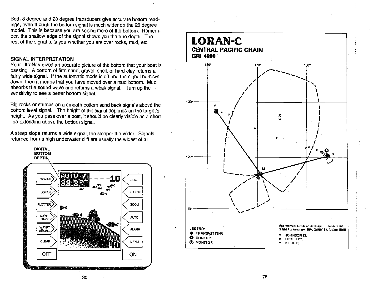
Both 8
ings,
model. This is because
ber,
rest of the
degree
even
the
and
though
shallow
signal
20
degree
the bottom
of the
edge
tells
you
signal
are
you
signal
whether
transducers
seeing
shows
you
give
is much wider on the
more of the bottom. Remem-
you
are over
accurate bottom read-
20
degree
the true
depth.
rocks, mud,
The
etc.
SIGNAL
Your
passing.
fairly
down,
absorbs the
sensitivity
Big
bottom level
height.
line
A
steep slope
returned from a
INTERPRETATION
UtraNav
wide
then
gives
A
bottom of firm
signal.
it means that
sound wave and returns a weak
to see a
rocks or
extending
stumps
signal.
As
you pass
DIGITAL
BOTFOM
DEPTH\
an accurate
If
the automatic mode is off and the
you
better bottom
on a
smooth bottom send back
The
height
over a
above
the bottom
returns a wide
underwater cliff are
high
picture
sand,
gravel, shell,
have moved over a mud bottom. Mud
signal.
of the
post,
signal.
signal,
of the bottom
signal depends
it should be
the
steeper
usually
333FT
4-:
that
or hard
signal.
clearly
clay
signal
Turn
signals
on the
visible as a short
the wider.
the widest of all.
boat is
your
returns a
narrows
the
up
above the
target's
Signals
WAYPT
SAVE
WAYPTN
RECALL/
;. :r.c
-
":.
OIF ON
PDF compression, OCR, web-optimization with CVISION's PdfCompressor
30
75
Page 35

ARCHES
FISH
Fish arches
The distance
below.
are created
to a fish
When the center of
shorter as shown
increases
again
as shown
when the cone
when the cone
the cone strikes
As the cone
"B".
in "C".
of sound
passes
over a fish.
first strikes it is shown
the
leaves the
fish,
fish,
distance is
the
the
as "A"
distance
CENTRAL PACIFIC LORAN-C CHAIN CR14900
REGIONAL MANAGER
CHAIN MANAGER
COORDINATOR OF CHAIN
CONTROL SITE: OMSTA KANEOHE,
DESIG.
MSTER
IXMV
VAM(EE KURE ISLAND
COMMANOER. PACIFIC AREA. ALAMEDA,
14TH COAST GUARD DISTRICt HONOLULU,
OPERATIONS LOCATION: OMSTA KANEOHE,
HI
STATIOl
JOwsr'4
IGLANOHI
UPCLIJ OW
H'
HI
BOATS
CA
HI
HI
DIRECTION
OF TRAVEL
adln-
.1
1
A
is
When
the Fish
and
shape
example,
displayed
cone diameter and the
PDF compression, OCR, web-optimization with CVISION's PdfCompressor
74 31
I.D. mode
of the fish arch
if the cone
passes
on the UltraNlav
resolution limitations
the
off,
depth
due to the cone
over a
may
fish in shallow
not arch
at all. This is due
water will affect the
of the
angle
water,
of the
display.
B
diameter.
the
signal
to the narrow
size
For
Page 36

small fish
Very
a
partial arch,
fish
Large
arch.
Because of water
will
probably
or
a
arch,
thermoclines, etc.,
to
enough
fish arches.
get
will
not arch at all. Medium sized fish will
shape
similar to an arch if
but turn the
conditions,
the
sensitivity
they're
sensitivity up
sometimes cannot be increased
in
such as
deeper
heavy
in
deep
water to see the
surface
show
water.
clutter,
3. If
you're using
and
building,
(most
or
(NOTE:
purposes
the loran on
important) power
under a metal
The
se units are
and
carport, shed,
generally
land, keep
lines. The
designed
away
loran will not work inside a
etc.
for
work best on the
from
trees, buildings,
marine
(boating)
water.)
One of the best
segment
segment,
of the water. For
the better the screen
this on the UltraNav is
Bottom Track mode to
detail. For the best
without
getting
too much
this method should work to
If
see fish
you
fish
symbols
WATER
Water
temperature
signals
when the Fish I.D.
TEMPERATURE AND THERMOCLINES
ways
to
fish
get
example,
resolution will be. The easiest
with the Bottom Track feature. Use the 2x or 4x
turn
the
the
expand
results,
noisepn
display
when the unit is in
feature is
has
an.
important-if
the activities of all fish. Fish are
always
the
temperature
colder water slows
about a fourth as much
Most fish don't
narrow limits.
helps
identify
various
Bass and other
too
cold
species.
during
tolerance than
stay. Schooling
provides
here.
this
spawn
The surface
the desired surface water
fish
the summer. While some fish have a wider
others,
fish
temperature.
of
the
suritunding
down their metabolism. At this
food as
unless the water
Trout can't
eventually
they
temperature
$urvive
die out when stocked in lakes
each has a certain
suspended
We assume
arches is to
expand
from 45 to 60 feet. The
echoes,
sensitivity up
the
screen. In medium to
fish
arches.
making
the manual
on,
try increasing
not
cdntrolling-influerice upon
cold blooded and their bodies are
water.
consume in the
temperature
meter built into the
spawning temperatures
in
streams that
or "zoom" a
smaller the
way
it easier to see
as
mode,
as
high
deep water,
but don't
possible
the sensitiv-
During
summer.
the
time, they
is within rather
Ultra Plus
too warm.
get
to do
winter,
need
that remain
temperature
within
which it tries to
most comfortable
over
range
water lie at the level
deep
are the
they
get
for
that
4.
If
you're having
have a
may
that is
causing
then
try
doesn't
look for other
INTERFERENCE SOURCES or BAD
initializing
work,
trouble with the
of
piece
gear
interference. First turn
unit
such as a
the unit. Enter the
then
sources of interference.
the GRI. If the unit
try
Land Sources:
1.
Military
2.
Hydro-electric plants.
3.
High voltage power
4.
Storms. A storm
with the
5.
Mountains, trees,
in an
Boat
1. Boat
also be
2. Power cable
Route
3. Bad
open
4.
Fluorescent
installations.
signals,
open
Sources:
engine.
required.
power
!
antenna
on
area
(High power
lines. These radiate
between
even if
buildings.
area.
Resistor
routed to fuse
cable
placement.
the
boat,
lights.
(Dams)
and the
you
it's
many
These reflect the
spark
plugs help,
panel
directly
to the
The antenna should
from other
away
locking
radio,
initial
RECEPTION
transmitters in the loran
miles
instead of
battery.
on to the
bilge pump,
everything
position
still doesn't lock
(see
below)
noise at
loran station can
away.
signals.
alternator
directly
be
antennas or structure.
stations, you
or
in the boat
first. If
levels.
high
Try
noise filter
to
battery.
placed
engine
off,
that
then
on,
band.)
interfere
to
stay
may
in an
32
73
PDF compression, OCR, web-optimization with CVISION's PdfCompressor
Page 37

UNITS
MEASURE
..t1A1Jt;.:
"I
CHAhi'3 TO
r
MILES
OF
IN
FiiL•ES
C F S
RN
AND
Simply press
"CHANGE TO MILES
label and the UltraNav
the last used loran
the new units of measure.
To switch back to nautical
knots, repeat
will now read 'CHANGE
menu
NAUT. MILES AND KNOTS".
the
key adjacent
switch the units of
the
key adjacent
AND MPH"
will return to
screen, showing
the above
to that menu
measure.
mites and
steps.
to the
The
TO
Press
to
SURFACE
ABSORBS HEAT.
FROM
EPILIMNION
LAYER
THE SUN
830
78°
770
760
BACKLJGI-ITS
T
r SELECT
TheUltraNav's
are
backlighted
the
backlights
MENU
adjacent
label.
key,
Now
three times.
appears.
adjacent
ON/OFF"
will turn on. If
they
will turn them
LORAN TROUBLESHOOTING
1. You
2. For best
must have an 8' antenna.
antenna
preferably
will be
boat
using
of the
keyboard
for
on or
then
press
to the "CHANGE SETUP"
the MENU
press
The screen at left
Simply press
to the "TURN BACKLIGHT
label. lithe
off.
should be
results,
the main
grounded,
an isolated
battery.
The loran will work better if it's
PDF compression, OCR, web-optimization with CVISION's PdfCompressor
and
display
use. To turn
night
off,
lights
they
higher
wire the
battery,
the
press
the
key
key
the
key
are
were
on,
than
power
engine's cranking
since the lower unit
wire a
off,
this
Preferably,
anything
cable
grounding plate
72
'1
LEAP
directly
battery.
UNITS
F1EASURE,
'I________
the entire
else on the boat.
to the
This assures
is in the water.
to the
grounded
OF
________
of the
length
battery,
If
ground
to water.
b.
the
you're
side
The
temperature
bottom.
warm and cool
thickness of the thermocline
deep
are
active.
game
The UttraNav can detect
ity
Layers
lakes
important
Many
will
fish
will
probably
pf water in the
of different
of water is called
layer
there
to
times bait
suspend
be two or more at
may
fishermen because
have to be turned
fish wilt be above
in or
this invisible
-a?
c.
lake is seldom constant
temperatures
can
vary
THE RMOCLINE
'MOST pRoDucTivE
ZONE FOR
form,
a thermocline. The
the season or time
with
different
are areas where fish
they
the thermocline while
belowit.
just
in the
layer
see it.
to
up
33
FISHING
and the
depths.
but the
water,
68°
56°
500
470
from
junction
depth
of
Thermoclines
to
top
of a
and
In
day.
are
larger
sensitiv-
Page 38

SURVEYING A LAKE
The most successful
after
day
that
produce
where,
season. And
any
throughout
other factors.
With the
areas where fish are
The most efficient
survey
and indicate the
As
you go
of bottom. It will also
type
a few marker
Keep
the Ultra indicates a school of
thus
marked,
the
right spot.
lake. Unless
not be able to find it
and
day
and at what
the
Ultra,
it with
your
about
you
you
anglers
after
year
fish
consistently.
depth,
they
year depending
anyone
likely
way
UltraNav.
promising spots
your survey, your
buoys
can make
This is
mark the school of fish
again.
year. Eventually, they
they
realize that
can eliminate
to be. Even if it's the first
to become
reveal
in the
your
essential when
on
any
They
can
on water
acquainted
Start with a
in
suspended
boat,
throw the
fish,
turn and come back to fish in
of water are those who fish
body
learn the hot
discover
expect
guesswork
relation to landmarks on shore.
UltraNav will tell
to find the fish
these
level,
map
ready
you're
when
through experience
productive
temperature,
and concentrate on the
time
with a
body
of the
you
fish.
to toss overboard. When
out. With the school
buoy
far from shore on a
you're
they
areas
on the
of water is
if
lake,
the
over
it,
spots
want at
change
and
food,
lakef
possible,
and
depth
exactly
you may
it
to
big
Once the desired values are
"ENTER"
using
see if ASF's are in use. The letters "ASF"
corner
indicator.
label. The UltraNav will return
the corrections
of the
screen,
you
immediately
entered,
entered. Switch to
INDICATOR
press
to the last used loran
below the
ASF
AbJUST TO
OFFSETS
S
a
a
SELECT UNIT OF
ENT.
MEASURE
the
key adjacent
the
position
appear
in the
automatic/manual mode
to the
screen,
screen to
left
upper
AUTO SRI :?98C
'11SF
Posi
TLOtI
Pr
N 24°33.37
U131° 43.6W
FIX IS GOOD(S
135°
23.8 KM
56.8
BAIT FISH
The
importance
sized.
Bait fish are the
shad. Bait fish can also be the
bluegill,
Most bait fish concentrate within five feet of the surface where
promotes
of
feature
Usually,
bait fish.
They
and bass.
fishing
off,
is to use the UltraNav to find the bait fish first. With the Fish ID
game
of bait
are the
the
growth
A
school of bait fish will look like a "cloud" on the
fish will be
fish to successful
principle
plankton feeding forage
of the
food of all
young
plankton
nearby,
game
of
on which
often
directly
fishing
game fish,
can't be
fish in most waters.
such as minnows and
fish,
such as
feed. One method
they
beneath the school of
over-empha-
crappies,
sunlight
display.
The UltraNav can
speed
in knots or miles
4 .
__________________
.
display
distance
hour. When the UltraNav is turned on for
per
in
nautical or statute miles
the.
nautical miles and
To
the MENU
displayed,
to the
I
press
screen
Now
"SELECT UNITS OF MEASURE"
label. The screen at the
next
first
very
change
the
key
then
"CHANGE SETUP" label. Now
the MENU
shown at left
the
press
page
appears.
distance is in
time,
speed
units of
while a loran screen is
press
key
key adjacent
is inknots.
measure,
the
key adjacent
three times. The
appears.
to the
top
and
press
of the
ARF1OR
PDF compression, OCR, web-optimization with CVISION's PdfCompressor
34 71
Page 39

Now enter the
enter a zero at the
degrees.
number is entered.
exact
The screen below
latitude/longitude
beginning
of the
right appears
for
your position.
longitude
after the last
Remember to
if it's less than 100
longitude
IMPORTANT
SERVICE
INFORMATION!
If
ASF
LAT'LON
C
H———0
--.-w
H32°
U82°
ASF
LAT'
LON
18.07
5th33
C
-a
C
4
r Li rr r r.
rLAR
If
you're
adjacent
screen is
traNav will return to the last used loran screen,
offset
TU OFFSET
To
offset
to the "ENTER
label on the ASF menu. The
shown at
The offset
seconds
in
to the
the TD offset. Press the
to the
or the down
PDF compression, OCR, web-optimization with CVISION's PdfCompressor
east of
to the EAST/WEST
correct,
entered.
you
change
the ASF
method,
right appears.
or correction in micro-
is shown for each
the chain.
up
up
Press the
or down arrows to
arrrow to increase the
arrow to decrease it.
Greenwich, England (east longitude),
press
label.
the
key adjacent
Otherwise,
if
everything
to the ENTER label.
using
ADJUST
ID
the
using
the
press
TD CORRECTION"
adjacent
key
menu ______
secondary
key adjacent
change
key adjacent
value,
70
OFFSETS
\bJ. 0.00.
_____________
_____
a_
C.II icr
press
the
position
ENTER:;
_________
the
key
on the
The UI-
TO
unit is not
your
troubleshooting
tomerservice
the How To Obtain
SONAR
Unit won't turn
1. Check the
2. Make certain the
to the
positive
3. check the fuse.
Measurethe
4.
11 volts. If it
on the temiinals are
Unit
freezes,
1. Electrical noise from the boat's motor,
interfering
from other electrical
cable
directly
2.
Inspect
3. Check
securely plugged
Weak bottom
1. Make certain transducer
transducer.
Its effectiveness. If the transducer
shooting through only
hull. Do NOT use RTV silicone
working,
section before
department.
TROUBLESHOOTING
on:
power
battery
batteryvoltage
the
isn't,
locks
with the sonar unit.
to the
the transducer cable for breaks, cuts,
both the transducer and
echo, digItal readings
Oil, dirt,
or if
Service section on
cable's connection
power
terminal,
wiring
corroded,
or
up,
wiring
battery
to the unit.
in
andfuel
one
need technical
you
contacting
It
maysave you
page
at the unit. Also check
is wired
cable
to
black
atthe unit's
tothe
or the
operates
Re-routing
on the
instead
is
pointing straight
can cause afilmtoform onthetransducer, reducing
layerof
negative
unit is
defective,
battery
erratIcally:
boat
may help.
of
through
power
erratIc,
is mounted inside
fiberglass
rubber adhesive or Marinetex".
help, please
service center or the
a
thetrouble
38
properly.
powerconnector.
trolling
the
power
connectors. Make
and that it is
of
if
need service.
you
The
or
ground.
the
batteryterminals
needs
charging.
motor,
and
Route the
a fuse block
or
pinched
or no fish
down.
35
use the
returning yourunit.
red wire connects
It should be at least
or an
accessory may
transducer cables
sonar unit's
or
wires.
signals:
Clean the face
the
hull,
securely
following
factory
the
wiring.
orwiring
ignition
certain both are
switch
be sure it is
bondedto the
cus-
See
be
away
power
of the
Page 40

Weak bottom
2. Electrical noisefromthe boat's
the sonar to
This can cause the unit to eliminate
from the
3. The water
sonar can't find the bottom
flash
continuously.
are in. If this
you
to a realistic
range
move into shallower
you
4. Check the
also
drops, reducing
Bottom echo
bottom echo while boat Is
1, The transducer
echo,
automatically
display.
may
happens, place
one,
battery voltage.
disappears
digital readings erratic,
motorcan interfere with the sonar. This causes
increase its
weakersignals
be
deeper
It
may change
than
while it's in the automatic
signal
the unit in the manUal
(forexample,
water,
a bottom
the
If the
its
may
to find the
ability
at
hIgh speeds
moving -
be in
turbulent water. It must be mounted in a smooth
flow of water in order for the sonar to
water
other
disrupt
targets.
the sonar
The technical term for
signals, interfering
or no
fish,
Discrimination or noise
such as fish or even structure
the sonar's
to limits far
range
0-100
feet)
signal
voltage drops,
bottom or
or erratic
work at all boat
with its
this is Cavitation'.
to find the
ability
and increase the
should
the unit's transmitter
targets.
digital reading
speeds.
ability
signals (cont.):
rejection
mode,
greaterthan
then
mode,
appear.
feature.
bottom. If the
the
digital
the water
change
sensitivity.
power
or weak
Air bubbles In the
to find the bottom or
will
the
As
ASF
corrections entered
in use at the time
from the
tions
matically
latitude/longitude position
apply
Remember,
area,
not be usable if
may
changes
the
ASF correction to the stations in use
the ASF will have to
To
change
displayed.
label. Press
adlacent
appears.
latitude/longitude
cally
the
Now,
to the "ADJUST ASF" label. The
This menu lets
turns the ASF feature on.
and location
the ASF correction
stations. This
if
you
change
be re-entered.
first
ASF,
the
press
the MENU
correction.
IMPORTANTI
the user are
by
corrected, If
being
not be valid. ASF
may
you change stations,
especially
to
change
stations,
press
key adjacent
one more
key
you change
Entering
the
ASF. The
especially
MENU
to the
time,
the ASF
the
for
good only
the stations
travel
you
away
correc-
or if
the unit auto-
holds true if
UltraNav
-
not all of them.
if
you change GRI's,
while
key
a loran screen is
you
will
enter a
only
"CHANGE SETUP"
then
screen shown beloW
using
ASF correction automati-
the
press
TD offsets or
key
2. Electrical noisefromthe boat's motorcan
the
sonar to
This can cause the unit to eliminate
from the
and transducer cables
No fish arches when the Fish ID
1. Make certain transducer is
problem
manual for more
2. The
arch,
until it leaves, If the
when it is in the center of the
3. Use the Zoom
in on a small
better luck
This
enlarges
automatically
display. Try using resistorspark plugs
if a
partial
information.
sensitivity may
it has to be able to receive
feature. It is much easierto
range
fish arches with a 30 to
seeing
the
targets, allowing
Increase its
away
arch is
displayed.
not be
sensitivity
of water
weakersignals
from other
feature Is off:
pointing
high enough.
the fish's echo from the time it enters the cone
is not
cone.
than a
large
the
PDF compression, OCR, web-optimization with CVISION's PdfCompressor
interfere with the sonar. This causes
Discrimination or noise
such as fish or even structure
or
electrical
straight
See the Fish Arch section in
high enough,
one. For
60 foot
display
36
routing
wiring
down. This is the most
In
orderforthe unit to
the unit
fish arches when
display
example, you
than a 0 to 60 foot
range
to show much more detail.
rejection
the sonar unit's
on the boat.
displays
will have
feature.
power
common
your owner's,
a fish
display
the fish
only
zoomed
muth
range.
Latitude/Longitude
Use the
latitude/longitude position
the
latIlong
display
is
slightly
your known, precise
displayed position
margin,
may
example, suppose your
longitude
the UltraNav
20.
the
Alternate/Primary
need to be
is
38-25-40/81-34-10,
displays
Simply
enter
ASF Correction
ASF correction if the _____________________
shown on
different than
position. (If
is off
switched.)
your
a
by
large
feature
For
actual
tatitude/
38-24-30/81-35-
actual
position,
and the lJltraNav will handle the
To
change
must be in the location
cent to the "ENTER
the
top
the
of the
ASF
using
LAT/LONG CORRECTION"
next
page appears.
you
the
latitude/longitude correction,
are
__________________
the
but
--TO k
LAT
/LQN
a
ri ',..n
rest. ________
MORE'
you
changing. Next,
press
the
key adja-
label. The screen at
69
first
Page 41

NMEA
The UltraNav can
according
formats.
off
the
To select the
MENU
displayed.
cent to the 'CHANGE
Next,
Finally, press
The screen shown
Simply
return to the last
wire.
INTERFACE
send data out
to NMEA 0180010183
The NMEA
output
when the UltraNav is turned on for
first time. _____________________
very
key
press
SELECT
NMEA
while a loran screen is
Now
the
the
NMEA OUTPUT" label. _______
output, press
press
MENU
key adjacent
below
a
press
(See
key adjacent
loran screen and
Power Connections section for
the
is turned
the
key adja
SETUP" label.
two times.
key
to the
appears.
to the desired
the
output
S
____________________
4
_____________________
4
output.
data
ASF Correction
Loran
signals
lakes, mountains,
different
factor,
or ASF.
However,
between the chart and the real
are affected
ways.
ASF's
and cities affect
This effect is called
It's
usually
from
vary
There can also b a difference
displayed by
the
loran,
due to
distorted from their theoretical
shifted,
actual
the loran shows a TD or
position.
terrain
by
the
the
they
signal
and
the additional
factored in when a loran chart
to
place
world.
in
your
ASF. In this
position.
latitude/longitude
so there can be differences
place,
actual
case,
Since the measured
The UltraNav has an correction feature that lets
This forces the loran to use a new ASF instead
in its
memory.
entering your
You can shift the ASF
actual
latitude/longitude position.
changing
by
I
OUTPUT
IS
OFF
Select
CIJT
HMEn 0183
1
The NavGuide will
on the white serial data
wiring instructiops.)
travel over. Plains,
each affect
they
secondary phase
position
and the
the loran
that is not the
you change
of the one that
the TD offset
is made.
signals
it in
one
TD's are
the ASF.
resides
or
are
by
boat must be
4. The
is
motionless,
lines.
fish
moving
stay
at aslow
in the
cone, showing
ELECTRICAL NOISE
A
major
sonar's
completely
at all.
or not
To eliminate or minimize
cause.
electrical
unit does NOT
turn on
off,
display.
effect on the
sonardisplayfor
VHF radio
turned
and
ASP,
board,
noise,
seconds after the unit is turned
If
find
you
or
radio,
power
interference.
certain to
unit's
powercable
It no noise
certain
Increase the RPM
the
problem
wiring. Try using
power
the
battery helps
supplied
When no noise
noise source is
experience
water,
will be the location and/or
must be
Read
of sonar
cause
display
cover the screen with
With the boat at rest in the
equipment
have ASP
your
Now turn
sonar's
and transmit.
theireffect onthe
on,
can't turn it
you
one at a
the ASP feature
since
noise interference from
to isolate the
try
cable and
VHF radio antenna cables radiate
keep
displays
everything except
could
cable
away
with the unit when
make
orwhen the boat is at rest. In
placed
transducer owners manual for the
your
problems
as random
sonar unit. There
on each
noise. if no noise
time,
transducer cable
patterns
the effects
on the boat off.
(Advanced
piece
display. Forexample,
Keep
sonardisplay
off,
then turn on
problem.
the sonar's wires
directlytothe
on the sonar unit
the sonar unit is turned
with the
be one of three
resistorsparkplugs,
from
eliminate
appears
probably
hasty
a location that has a smooth
in
gearshift
engine wiring. Again,
noise
wiring
on the sonar unit
cavitation.
sonar installations which function
angle
trolling speed
is electrical noise. This
to seefish arches. If the
onthe
display
usually appears
of dots or lines. In severe cases,
black
of electrical
water,
Make certain the
of electrical
is
doing
first turn on each
the sonar unit You will have to
starts
on.
an electrical
away
batteryto
or cause the unit
dots,
first
noise,
the first
Signal Processing),
should be a
present,
this until all electrical
eliminating
You
away
from It. You
from electrical
thing you
engine
steady
equipment
turn on the
turn the
noted,
piece
Instrument, trolling
can
usually
from the
isolate
on the boat
bilge pump
pump
then turned
of electrical
noise fromthe
re-route the
wiring
noise when
may
itfrom
need to
otherwiring
equipment,
oft
spark
If noise
plugs,
appears
alternator,
or
the
routing
certain to use the in-line fuse
Make
cable to the
after all of the above
or
the cause
flow of water at all
mounting position.
all
cases,
novices
best
in neutral.
things;
alternatorf liters,
problems.
the
power
Many
nearly
transducer. The face of the transducer
of the
as
straight
try
should
is off,
if
or
bottom
off,
equipment
off. If
that is
transmitting,
then start the
routing
powercable
battery.
persons
perfectly
horizontal
operate
to determine the
do is turn all
also. If
can turn ASP
you
signal
and viewthe
and
then turn on the
has been
your
equipment
look
quickly
display
motor,
sonar unit's
causing
route the sonar
on the boat.
then
on the
ortachometer
the sonar
tests,
with limited
in shallow
of the malfunction
boat
boat
on the
it can
erraticly,
your
on the
view the
unit has
on
for
a few
pump,
the
so be
make
engine.
display,
unit's
directlyto
the
then
speeds.
PDF compression, OCR, web-optimization with CVISION's PdfCompressor
68
37
Page 42

How to Obtain Service
ARRIVAL ALARM
We
back
genuine
authorized
will
help you
Customer Service Center.
Service Center are
surface carrier at no
investment in
your
Eagle replacement parts.
Service Center nearest
Eagle
find the closest
your
charge.
quality products
repairfacility.
Transportation expenses
responsability.
Factory Repair
If
unit needs
your
use
the
following
EAGLE ELECTRONICS
Att: Service
12000 E
Tulsa,
You
Customer Service
technician
returning your
For the
When
do the
1. Use the
shipping your product.
2.
Always
For
describing
address,
IMPORTANT: Be sure to include
product
Department
Dr
Skelly
OK
74128-2486
can call or write to an authorized
be able to solve the
may
unit.
Eagle factory
sending a product
following:
original
insure the
proper testing, repair,
the
and a
if it is still in
and
repair,
address:
Department
box and filler material the
problem.
daytime
you
customer service
to the
factory
parcel against damage
and
Be
telephone
warranty.
with
If
need service or
you
you.
If desired
The
wish to write or send a
Eagle
before
sending your
problem
service,
sure to include
and save
department,
or a service
send a brief note with the
number.
of
proof
quick, expert
The enclosed Service Center List
you
to us or to the Authorized
product
or
will
Service Center or the
you
call 1-918-234-1452.
center,
product
loss
durlhg shipment.
your
purchase
service and
repairs,
can contactthe
be
product
unit in for
the inconvenience of
we recommend
was
name,
when
contact the
returned
to the
packed
return
sending
Factory
to
you by
factory,
Factory
rppair.
in when
product
shipping
the
A
you
The arrival alarm sounds a tone when
alarm's radius of a
come with .1 nautical miles of a
is .1 nautical mile.
waypoint.
For
example,
waypoint
a A r r iv a. 1
Radius
a C.D.L
Linit
<MUTE
To
adjust
plotter
Press the
increase the
the
C.D.I. ALARM
The C.D.I.
amount as the alarm
nautical
nautical
on
To
is
key
screen is
key adjacent
miles,
miles. The C.D.I. alarm
the
Steering
adjust
displayed.
adjacent
ALARM
the
arrival
alarm, press
displayed.
key adjacent
radius,
alarm sounds when
the C.D.I.
to the
the down arrow to decrease it or turn
to the EXIT
setting.
then the alarm will sound if
Screen.
alarm,
The screen shown
up
the down arrow to decrease it or turn
the C.D.I. indicator's limits are
key
adjacent
to the EXIT label to return to
I
the ALARM
The screen shown above left
to the
arrow on the
arrow on the arrival alarm's menu to
up
label to return to the loran screen.
are off course
you
For
example,
adjust
the
press
ALARM.key
above left
C.D.l.'s alarm menu to increase
preset
your position
is within the
the alarm will Sound if
if
the arrival alarm's
Arrival
S
setting
Radius
a C D. I.
Linit
MUTE ALARM
C
while a loran or
key
appears.
off.
it
the same
by
if the alarm
you're
also
changes
appears.
setting
off course
the O.D.l.
while a loran screen
Now
it off. If the alarm is turned
to .1
nautical mile. Press the
the loran screen.
is .1
.1
by
press
you
I
Press
range
the
it,
off,
PDF compression, OCR, web-optimization with CVISION's PdfCompressor
38
67
Page 43

each
waypoint,
waypoint
route.
the UltraNav will
on the list. This continues until
automatically
switch to the
you've
next
travelled the entire
Canceling
To
stop
then
adjacent
sequencing through
show
Erasing
To
erase a route,
the "ROUTES" label. Now
ROUTE" label. The screen shown below
The asterisk shown to the left of
Route 1 and Route
these routes have
To erase Route
key adjacent
To erase Route
that has the asterisk
the
keys adjacent
arrows. This moves the list of routes
or down.
up
is in the selection box at the
screen,
"SELECT"
erased,
a Route
the UltraNav from
the
press
key adjacent
navigating
to the ROUTES label.
to the CANCEL ROUTE label. The UltraNav
the
waypoints
navigation
data to the last
a
route,
on the route.
waypoint
in
use.
a Route
the MENU
press
2
signifies
waypoints
1,
simply press
to the "SELECT" label.
or
2,
any
displayed,
to the
up
When the
the
press
label. The
and the UltraNav
desired route
key adjacent
route
press
that
saved.
the
other route
use
or down
of the
top
to the
will
be
will
return to
then
key,
the
key adjacent
appears.
_________________________
IcEOUTE 1102
ROUTE 1103
—
ROUTE 1104
press
However,
press
to the
ROUTE
_______
_____
the last loran screen.
LORAN ALARMS
The UltraNav has two loran alarms. One is an arrival
sounds when
other is a CDI. alarm that sounds when
than the alarm's set
come within a
you
point.
preset
distance to a
move
you
the MENU
Now
will
press
stop
key,
the
it will still
the
Icey adjacent
"ERASE
1105
alarm that
waypoint.
off course more
The
key
to
ULTF?ANA
LORAN
OPERATION
WARNING!
USE THIS LORAN RECEIVER
NAVIGATION.
NEVER RELY ON ONLY ONE
I
MAKE CERTAIN THE LORAN
POSITION IN
COORDINATES BEFORE NAVIGATING
THE POSITION MUST
NAVIGATION FEATURES TO
A CAREFUL NAVIGATOR
POSITION INFORMATION.
NOTICEI
LATITUDE/LONGITUDE
V
ONLY AS
METHOD TO OBTAIN
IS DISPLAYING THE CORRECT
BE CORRECT FOR THE
WORK PROPERLY.
AN AID TO
SHOULD
WITH THIS UNIT.
PDF compression, OCR, web-optimization with CVISION's PdfCompressor
66
39
Page 44

LORAN TABLE
OF CONTENTS
Following
a
Route
LORAN-GENERAL 41
ACCURACY
HOW LORAN-C WORKS 42
INSTALLATION - ELC-1 LORAN MODULE
OPERATION 44
INITIALIZATION
SELECTGRI 45
SELECT INITIAL POSITION 46
STATION DATA SCREEN
AUTOMATIC AND MANUAL MODES 48
MANUAL STATION SELECTION
PRIMARY AND ALTERNATE SOLUTIONS 50
SHOW TD'S 51
TRUEAND
LORAN DISPLAYS
POSITION SCREEN
STEER INDICATOR AND NAVIGATION SCREEN 54
NAVIGATION SUMMARY SCREEN 55
PLOTTER 56
USING THE PLOTTER WITH A WAYPOINT 57
PLOTTER MENUS 57
CLEAR PLOTTER
SELECT PLOTTER RADIUS SIZE 58
SELECT PLOTTER UPDATE RATE
WAYPOINT NAVIGATION
HOW TO SAVE A WAYPOINT
SAVING PRESENT POSITION AS A WAYPOINT
SAVING PRESENT POSITION
ENTER NEW WAYPOINT/GO TO WAYPOINT 60
WAYPOINT RECALL
ERASEAWAYPOINT 62
ROUTES
CREATINGAROUTE 63
FOLLOWING A ROUTE
CANCELLING
ERASING A ROUTE 66
LORAN ALARMS 66
ARRIVAL
C.D.I. ALARM 67
NMEAINTERFACE
ASE CORRECTION 68
LATITUDE/LONGITUDE
TD OFFSET ASF CORRECTION 70
SELECTUNITSOFMEASURE
BACKLIGHTS
LORAN TROUBLESHOOTING 72
MAGNETIC
POSITION
-
VIEW AND SAVE
(QUICK SAVE)
A ROUTE 66
ALARM 67
ASF
CORRECTION
41
43
44
47
49
52
53
53
58
58 ____________
59
59
59
60
62
63
65
68
69
71
72
To follow a saved
route, press
to the ROUTES label. Now
FORWARD" to follow a route from the first
the
press
MENU
the
key,
key adjacent
waypoint
"RTE BACKWARD" to follow a route from the
first. The screens are
the same. In this
appears
pressed.
An asterisk
routes that have
Move the list
keys adjacent
labels Until
selection box
Route number one is used in this
example.
after the
appears
up
to the
desired
the
at the
Press the
virtually identical,
example,
key adjacent
route forward is used. The screen below
to the "RTE FORWARD" label is
to the left of the
waypoints assigned.
or down
using
and down
up
route is
of the screen.
top
key adjacent
the
in
the
to
and
instructions for both are
_________________________
P.OUTE
*ROuTE *02
ROUTE StUB
-ROUTE *04
ROUTE *05
the 'SELECT" label. The screen
shown below
appears.
EXIT
I
____
_______________
-
N 21°53.D5
2 U 78° 24.51
PICK A UPt
TO START
ROUTE #01
FORWARD
SELECT
S
a
Now choose
the route. The default is
number
a
a
ample,
route from
The UltraNav will show
data to each consecutive
the route after the first
selected.
adjacent
until the desired
selection box at the
Press the
"SELECT" label
and
point
the first
one,
however
any waypoint
Again, press
to the
key
start the route.
then the
key
adjacent
to the "RTE
last
to the
waypoint
last,
to the
or
ftOiY
_____
_______
as shown in this ex-
you
and down labels
up
waypoint
adjacept
to choose the
________
waypoint
waypoint
can start the
in
the route.
navigation
waypoint
waypoint
the
keys
in
is
of the screen.
top
to the
to start
the
way-
is
in
-
The UltraNav Will show
the
waypoints
PDF compression, OCR, web-optimization with CVISION's PdfCompressor
40 65
in the route. As
navigation
and
plotter
come within .1
you
information to each of
nautical mile of
Page 45

Loran - General
ROUTE
the desired route number is in
Once
the
box, press
"SELECT" label.
route number
screen shown
the
key adjacent
In this
example,
one is used. The
below
appears
N 31°53.D6'
2 LI 78024.51
SELECT
FOR
ROUTE #01
—
a
Continue
order
until
been
Each route can have
points.
add an undesired
press
ROUTE" label.
waypoints
start the selection
After
points, press
"EXIT"
the last used loran
selecting waypoints
wish to travel in the route
you
all of the desired
picked
If
you
the
key
in the route. You can then
selecting
label. The UltraNav returns to
UJPTS
—
ti
QU
waypoints
for the route.
up
make a mistake and
waypoint
adjacent
This erases all of the
all of the route's
the
to the
process
key adjacent
display.
PDF compression, OCR, web-optimization with CVISION's PdfCompressor
to the•
next.
This is the
lets
route. Press the
or down arrows to
up
list of
point appears
the
adjacent
small "01"
point's
that this is the
route.
in the
have
to ten
way-
to a
route,
"CLEAR
over
again.
way-
to the
64
you pick
waypoints.
top
ROUTE 1103
ROUTE
ROUTE
I
waypoint
the
of the
to the "SELECT"
appears
number.. This
selection menu. It
waypoints
keys adjacent
scroll
When the first
in the selection
screen,
first
press
above
lets
waypoint
31°53.O6
N
2 U 78°
SELECT
FOR ROUTE
<44S
1102
1104
1105
a
for the
to the
through
the
label. A
the
you
in the
24.51
iiiuirnj
the
way-
box at
key
way-
know
UPTS
#01
UtfltE.H
ui
+1
This section covers the
Loran.
UltraNav
Loran is short
that uses
sensitive receivers. Thus,
distances.
Loran was
was called Loran-A
and
version, Loran-C,
distances than
ACCURACY
The absolute
miles,
to return to the same
between the two
tells
find
However,
numbers above
affects the
chance for
it can
If
you
that is
Once
information on the UltraNav to the chart.
The ELC-1 Loran-C
for
position
for
Long RAnge
powerful
developed
development
depending
where
you
way
your
the
accuracy.
position
down to
vary
wish to double check
clearly
you arrive,
low
and used
and
continued
was introduced
Loran-A and it's easier
accuracy
on
your
spot)
types
are
you
back to the same
accuracy you
suggest.
error.
thirty
marked with
let the Loran
information.
frequency
operated
of Loran is between
of
on the
The
NOTE:
installation and
module must be
Navigation.
(100 kHz)
can
you
during
at
during
in
location.
is 100 feet or belier.
accuracy
map. Repeatable
site time after time.
experience may
The
crossing angle
sharper
A
ninety
your
settle,
without a
Loran,
41
degrees
latitude/longitude
operation
determine
World War II. At
a
higher frequency.
the fifties.
sixties. It works over
the
to use.
Repeatable
is
important.
the
crossing angle,
degree
first
then
compare
It should be
of the UltraNav's
attached to the
It's a
navigation system
transmitters and
radio
your position
The current
0.1 and 0.25 nautical
accuracy (your
The difference
Absolute
accuracy
be as
not
of the
crossing angle
large position
a
spot
pick
marks.
the
over
that time it
Research
Loran
accuracy
lets
good
lines of
the more
is
error.
on the chart
Then
go
position
close.
very
longer
as the
position
best,
to it.
long
ability.
you
but
Page 46

MOW
LORAN-C WORKS ROUTES
The Loran
are
called a "chain." The letter "M"
inside the chain. The other
Their names
secondary
with the
interval
a
different GRI.
The
master station
dreds of miles
transmitter to reach
difference between
UltraNav
your
seconds.
your
tion
is an
and one of the secondaries
located somewhere on
system
stations. The
master which transmits at
is called the
secondary
automatically
location. The time
Plotting
position
imaginary
consists of
are
W, X, Y,
stations transmit at
transmits. Since these transmitters are
apart,
and
secondary
Group Repetition
it takes a different time for
The Loran
you.
the master and two of the
chooses the best
difference or
the TO on
somewhere on
line on
the 14605.2 LOP.
three to five transmitter stations.
designates
stations in the chain are the secondaries.
Z, although
transmitters are
precise
Interval or GRI. Each chain has
precise
receiver measures this time
master-secondary pairs
(TO)
the master station
not all chains have four
synchronized
time intervals. This time
time
intervals after the
located hun-
the
signals
secondaries. The
is
measured in micro-
a chart with Loran-C lines results
a line of
which the time
is the same. In this
position (LOP).
delay
A line of
between the master
example
These
from each
with
posi-
the
boat is
for
The UltraNav
This feature is called Routes. A
points.
information
waypoint,
matically
this
waypoint
for the next
waypoints
There are two
select the route
To follow a
decide whether to follow the
are
steps
Creating
To create a
loran mode. The
cent to the ROUTES
Next,
press
screen shown
A
gives you
When
you
to the first
the arrival
selected
until the arrival alarm sounds and
waypoint.
in
the route.
steps necessary
number. Then
route, you
completed,
a Route
route,
the
key adjacent
below
the
ability
run a
waypoint
alarm
the unit.
by
This
simply
the UltraNav
route,
sounds,
Navigation
happens
determine the
route forward or backward. After these
the UltraNav will start
first
menu on the left
label. The screen shown
press
the MENU
to the "CREATE ROUTE"
right appears.
to
to several
go
route consists Of two
givesyou
in the route. As
then the next
you
waypoint
information is
the
until
you've
travelled
to create a route.
the
pick
aypoints
key
appears.
starting waypoint,
navigating
while the
Now
press
below left
waypoints
or more
navigation
reach the first
is auto-
displayed
process
repeats
to all the
First,
to use in
must
you
the route.
on
the route.
unit is in the
the
key adja-
appears.
label. The
in
a row.
way-
then
for
I am] j1i14 NI
athN!Th1 &I1
ROUTE
ROUTE
ROUTE fl04
1102
U03
ROUTE 1105
—.
The Loran receiver
master
31882.8. If
the first
lines.
and another
you
line-of-position.
PDF compression, OCR, web-optimization with CVISION's PdfCompressor
then measures the
secondary.
this LOP on
plot
Your
position
time difference between the
The
example
a
chart,
is at the intersection of the two
42
on the next
notice that it crosses
you'll
page
is
The
UltraNav has the
ber one
adjacent
into the
through
to
selection box at the
the
top
to store
on
of the
63
capability
five are
up
displayed
or down label to move the
twenty
routes. Routes num-
the screen. Press the
desired route number
screen.
—
key
Page 47

WAYPOINT
RECALL
You must recall
screens.
menu shown
Four
waypoints display
screen.
points
the
adjacent
This moves the
numbers
desired
the reverse
the
SELECT label. The
played
recalled and the UltraNav
to the loran screen. To exit from this
screen without
simply press
To recall one of these
other than the one at the
screen, simply press
to the
waypoint
screen, press
at the
a
waypoint
To recall a
below
appears.
or
up
list of
or down.
up
number
video area at the
the
of the screen will be
top
recalling a waypoint,
the
key adjacent
to use the Steer
waypoint,
on this
down labels.
waypoint
When the
key
waypoint
first
way-
the
key
appears
top
next to the
dis-
will
return
to the
press
top
in
of
Indicator or
Waypoint
rn
of
H
'U
"IN
"U
aN
Navigation
Recall
key.
The
31°5O,.O3
78°2211
31°48.31''
78° 19.01
31°43.24
'U 78°25.30'
t
a_
Exit label.
k
All Loran-C receivers work on this
also
display
and, using
longitude position
on the UltraNav to determine
tude
If
you
Coast Guard's book
book that describes
latitude/longitude.
a
complex
wish to know more about
mathematical
data. You can
"Loran-C USER HANDBOOK."
Loran in
The receiver
Loran-C,
greater
principle.
formula,
display
position.
your
detail.
Most modern receivers
takes the TD information
converts it to Iatitude/
both TO's and
order the United States
latitude/longi-
It's an excellent
ERASE A WAYPOINT
To erase a
first
list,
key.
the "ERASE A WAYPOINT' label.
This screen
the
keys
labels to
or
up
is in the black
press
"ERASE" label.
waypoint
To return to the last used loran
screen, press
"EXIT" label.
position
press
Now
press
appears. Simply press
adjacent
move the list of
until the desired
down
the
key
from the UltraNav's
PDF compression, OCR, web-optimization with CVISION's PdfCompressor
from the
the WAYPOINT SAVE
the
key adjacent
to the
selection box.
adjacent
This will erase the
the
key adjacent
waypoint
or down
up
waypoints
waypoint
Now
to
the
memory.
to
to
the
62
ERASE
LJAYPOINT
N3EtdL42i.!
1.
72° 33.51'
4
32° 14.16'
E
73°02.03'
S
a_
Loran-C User's Handbook
COMDTINST M16562.3
Documents
Superintendent
U.S. Government
Washington,
Code
#050-012-00171-5,
There is a small
INSTALLATION
When
choosing a mounting
where it's clear of other
A
antenna
be
VHF
location is
high
mounted
radio antennas.
of
D.C. 20402
charge
shouldn't
vertically.
Printing
for the
-
ELC-1
antennas, wires,
preferred,
be the
Make certain it is as far
Office
1980
book.
Loran-C MODULE
location,
however for
highest pad
remember to install the
masts,
lightning protection,
of the boat.
42
ELC-1
or other obstructions.
the
The antenna should
away
as
possible
from
Page 48

Improper performance
close to
places
and obstructed.
You must
antenna. The threads are
mount base is most
The base
(NOT pipe thread).
hardware.
The
cable
extension cable is available if the cable is too short. Ask
or call
Service
The ELC-1 can be attached to a swivel
mast,
metal
the
Loran
purchase
mounting
cable
supplied
if
it's too
your
department
if desired.
objects
Tighten
long. Instead,
local
OPERA11ON
INITIALIZATION
The Loran must be
used. Once it finds
time
power
hundred miles from the
shouldn't have to
is turned off. If
can also occur if the antenna is mounted
such as
assembly
an
eight
commonly
threads are
This
all hardware
with the ELC-1
service center or the
for more information.
initialized or "told where it is" the
your present
last time
repeat
tuna towers.
in the clear is
foot
stainless steel or
standard 3/8"-24 for the
used to mount the Loran to the boat.
conventional 1"-14 machine thread
allows the use of standard antenna
securely.
is
thirty
coil and store it out of
position,
don't travel over
you
turned the loran off
you
this
step.
Again,
preferable
fiberglass whip
feet
long.
Eagle Factory
bracket
or
hollow extension
the UltraNav stores it each
approximately
a location that
to one that is
A ratchet
whip.
mounting
Do not cut the
the
Customer
very
An
way.
dealer
your
first time it's
one
1
you
too
high
Now
enter the
member to add a zero to the
tude if it's less than 100
The screen shown below
after the last
entered.
LAT
P4
320
U82°
waypoint
longitude
/
LON
LPJPT
18.07'
5(133'
location.
degrees.
appears
number is
ENTER
aLAT'LON
longi-
"
Re-
H
w
WPT
0
0
':w
C
C
4
If
are
you
(east
longitude), press
cent to the EAST/WEST label. Other-
if
wise,
correct,
ENTER label.
The screen below
everything
east
press
of
Greenwich,
the
on this screen is
the
key adjacent
appears
England
key adja-
to the
next.
THE COUPLER
MUST BE
When the UltraNav is turned on for
the
LORAN
right appears.
using
adjacent
If
you
and
the
the "ENTER INITIAL POSITION"
label.
first
very
key,
the GRI
to the "SELECT GRI"
know
want the loran
you
GRI,
press
and
time,
the screen shown at
To initialize the
search, press
your present position,
the
key adjacent
you press
loran
the
label.
to choose
the
key
to
44
INITIALIZED
4
—
.
This
menu
gives you
You can save the
next available
"SAVE AS #" label at the
tcreen. The VIEW/SAVE menu
stores the
desird.
you
Position. -View and
Finally, you
waypoint
the
key adjacent
WPT" label.
number,
waypqint
(See
can
and not save it
three choices.
waypoint
using
fop
under
the
Saving
Save
Method.)
travel
directly
by pressing
to the "GO
under the
the
of the
any
Present
TO
number
to the
61
tzEIMan
.11
sS
PDF compression, OCR, web-optimization with CVISION's PdfCompressor
Page 49

loran at
The
waypoint
don't have to
you
stored the
Save
It's
easy
Saving
The Quick Save"
number.
method.
first
press
'VIEW/SAVE"
shown below
Your
present
the screen.
topof
this
waypoint
than the one
the
key adjacent
labels.
numbers
point
desired
the reverse
next to the SAVE
displayed
be saved under
number increments each
keep
waypoint,
home dock or
your
tile
to remember
Present Position - View
feature doesn't
You have to use the next
To save
the
your present position
Waypoint
label. The screen
appears.
position displays
If
you
under a number other
displayed, simply press
to the
This moves the list of
or down. When the
up
video
the
top
this
number
area,
label. The
of the screen
number,
waypoint
at
UltraNav will return to the
screen. To exit from
the
press
Enter
key adjacent
New
Waypoint
this screen without
time
track of the
UltraNav returns
launching ramp
home is number one
waypoint
to the loran
TIP
and Save Method
allow the selection
available number
under
key,
then
press
Save
at the
want to save
or down
up
way-
appears
press
loran
the EXIT label.
to
/ Go To
in
the
key
waypoint
will
then the
Waypoint
saving
save a
you
numbers.
display.
as
waypoint
when
you
of a
when
any waypoint
the
key adjacent
SAVE
31°26.09'
N
Ui 83°
AS UJPT
a
waypoint,
waypoint,
Once
number one.
so
you've
want to return.
waypoint
that
using
number,
to the
62.38'
1t1
simply
You can re-initialize
(Note:
Initial Position features
features tell
these
initialization
SELECT
Use this
calculate
charts
area.
the loran
"CHANGE
"SELECT
appears.
GRI
function if
your present position
in the back of this
Once
screen is
SETUP" label.
CR1" label. A screen
The GRI for the
The chain's
this
shown.
To
change
adjacent
to the
This scrolls the
display
chain is
press
window.
displayed
the
key adjacent
SELECT label.
revert to the
and
window
CR1". The
place
on the
the
the stations within
Once it finds the
processes
doesn't need to find and
mine the
latitude/longitude.
stations with
how to access these
is
identical.)
you
know the
you
displayed.
name is
example,
the CR1,
or down labels.
up
chains
When the desired
in the
The UltraNav
last used loran screen
following
screen;
UltraNav then looks
the selected chain.
stations,
the
signals
signals
good
the UltraNav's loran station
To save
Waypoint
to save the
a
waypoint
Save
waypoint using
to the "INPUT
the
key adjacent
waypoint
longitude
are identical.
method.
PDF compression, OCR, web-optimization with CVISION's PdfCompressor
other than
key.
The
your present
waypoint
latitude/longitude, press
save menu
LL WPT" label. To save
to the "INPUT TD WPT"
For this
The screen at the
example,
top
60
position,
a
waypoint
label. The
we'll use the Iatitudef
of the
first
appears.
the
using
steps
next
page
key
press
If
you
adjacent
TD's,
to save
appears,
the
wish
press
"STATION DATA" section
the
necessary
latitude/longitude.
a
usable. When the
for use.
WARNING:
stations in the
DO NOT NAVIGATE
(EITHER
the
are menu
know
don't
using
manual for the
chain's
Now
Finally, press
chain is shown
below the
right
7980 is
CR1
the
press
through
key UNITED• STATES
the
window,
to the
will
message
"Searching
it
until it "locks on"
lock onto
However,
to calculate a
acquisition
in this manual. Until
chain and locks onto them,
means the
This
position
numbers
LAT/LONG
any
items. The
features
your position.
chain
the
proper
number, press
the
press
the
similar to the one
at the
,_...
in a
for
for
to each station in the
all the stations in a chain
it does need to lock onto
latitude/longitude.
and
latitude/longitude
stop
WHEN THE POSITION
OR
TD'S)
45
The Select CR1 and
time.
following
section on
from the menus.
The UltraNav
select.
you
chain to use
the menu
key adjacent
key adjacent
shown below
of the screen.
top
See the
in
key
to
to the
SOUTHEAST
-___________
_____________
___________
To view
signal strengths,
the loran finds all
it flashes
display
flashing,
IS
the loran is
DISPLAY
FLASHING!
The
will
your
while
the
______
______
chain.
to deter-
three
see the
of
the
is not
ready
It
Page 50
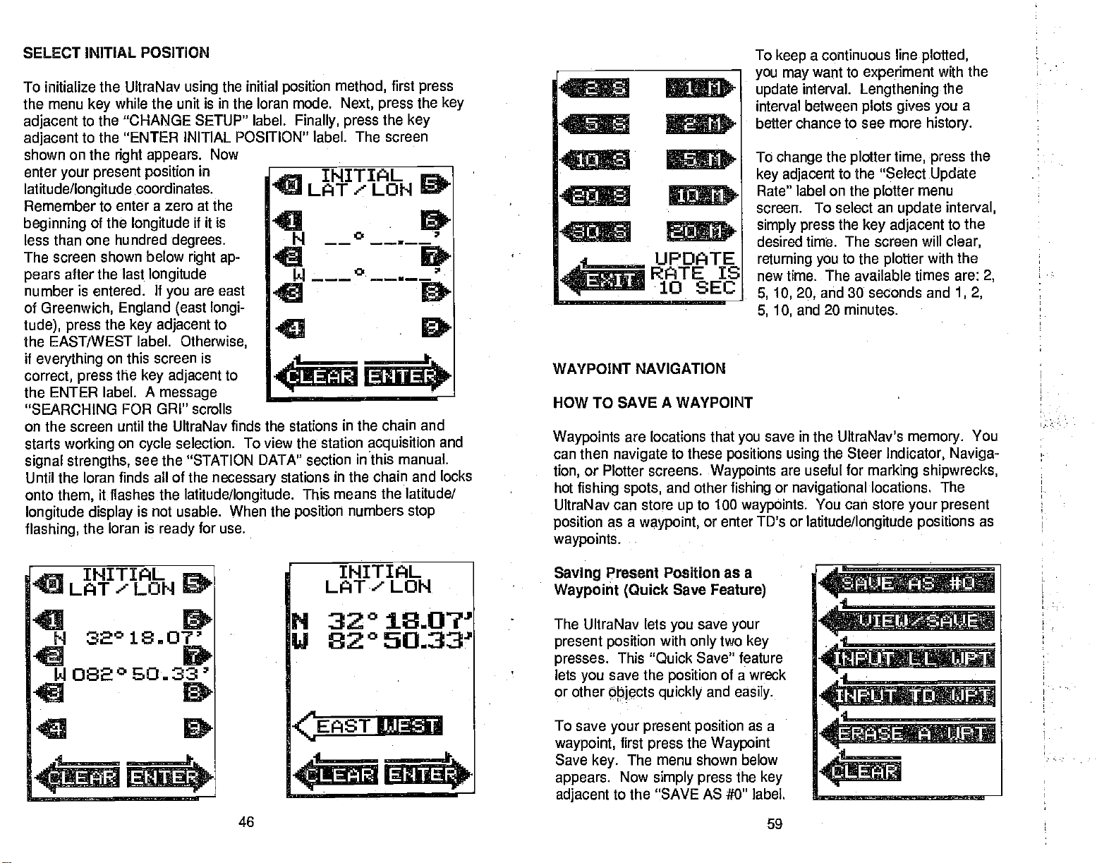
SELECT INITIAL POSITION
To initialize the UltraNav
the menu
adjacent
adjacent
shown on the
enter
your present position
latitude/longitude
Remember to
beginning
less than one hundred
The screen shown below
after the last
pears
number is entered.
of
Greenwich, England (east longi-
tude), press
the EAST/WEST
if
everything
correct,
ENTER label. A
the
"SEARCHING FOR
on the screen until
starts
working
signal strengths,
Until the loran finds all of the
onto
them,
longitude display
flashing,
while the unit is in the loran mode.
key
to the "CHANGE SETUP" label.
to the "ENTER INITIAL POSITION" label.
right appears.
coordinates.
enter a zero at the
of the
longitude
the
key adjacent
label.
on this
the
press
on
cycle
see the "STATION DATA" section
it flashes the
is not usable. When the
the loran is
using
in
if
degrees.
right ap-
longitude
If
are east
you
Otherwise,
screen is
key adjacent
message
GRI" scrolls
the UltraNav finds
selection. To
latitude/longitude.
for use.
ready
the initial
Now
it is
to
to
necessary
position
Finally, press
a
INITIAL
method,
Next,
first
press
the
press
the
key
The screen
JLATLOH
4
I ---s
.4
________
EI4TE
the stations in the chain and
view the
station
stations
This means
position
acquisition
in this manual.
in the chain and locks
the latitude/
numbers
stop
key
and
.4
UPDATE
RATE IS
•1O SEC
WAYPOINT NAVIGATION
HOW TO SAVE A WAYPOINT
Waypoints
can then
tion,
hot
fishing spots,
UltraNav
position
waypoints.
are locations that
navigate
or Plotter screens.
can store
as a
to these
and other
up
waypoint,
you
positions using
Waypoints
fishing
to 100
or enter TD's or
To
you may
update
interval
better chance to see more
To
key adjacent
Rate" label on the
screen. To select an
simply press
desired time. The screen will
returning you
new time. The available times are:
5, 10, 20,
5, 10,
save in the UltraNav's
waypoints.
a continuous line
keep
want to
interval.
between
change
experiment
Lengthening
plots gives you
the
plotter
time,
to the "Select
plotter
update
the
to the
and 30 seconds and
and 20 minutes.
the Steer
are useful for
or
navigational
You can store
latitude/longitude positions
adjacent
key
plotter
Indicator, Naviga-
marking shipwrecks,
locations. The
plotted,
with the
the
history.
press
Update
menu
with the
memory.
your present
a
the
interval,
the
to
clear,
2,
1,2,
You
as
n
INITIAL
%9LAT'LON
P432°
32018.0?'
U82°
S
082°E.O..33'
C
1:
PDF compression, OCR, web-optimization with CVISION's PdfCompressor
EfISH
46
INITIAL
LAT'
________
*:LEAR
LON
18.07'
50fl3'
IJEST:
I.
EttERi.
Saving
Waypoint (Quick
The UltraNav lets
present position
presses.
lets
or other
To save
waypoint,
Save
appears.
adjacent
Present Position as a
Save
Feature)
save
you
with
only
This "Quick Save"
save the
you
Objects quickly
your
first
key.
Now
to the "SAVE AS #0" label.
position
and
present
press
The menu shown below
position
the
Waypoint
simply press
your
two
key
feature
of a wreck
easily.
as a
the
key
59
a
.4,
4
______________________
________
Page 51

PLO1TER
Clear Plot
The Clear
track line. The
draw
pressed,
present position
MENUS
Plot" label clears the solid
track
your
however the
the screen.
(cont.)
plotter
will continue to
after this
will be centered
key
location of
is
your
on
STATION
1
4
SELECT
RADIUS
SIZE
a
UPDATE
4
The UltraNav's Station
for the stations
MENU
press
screen shown
and all of the
Stations that
example,
DATA
Data Screen
in the current GRI. To
two times.
key
the
key adjacent
are
below
secondaries in the chain
The screen shown
to the "STATION
right appears.
currently
the master and stations
displays
The TD's for the
all of the
view this
below left
DATA SCREEN".
display
in use are shown in
Y and Z are
technical data
screen, press
appears.
master station
top
of the
at the
reverse video.
in use.
the
Now
The
screen.
In this
SUt1I1AR?
SCREEN
a
SelectRadius Size
w Swe
SELECT RADIUS
___
IN
_____
NAUT. MILES
____
RADIUS
IS
______
Select
The
present position.
position
from 2 seconds to 20 minutes.
As each
after a certain
line,
that's a
not reach from the
Update
plotter
is
dot is
but still
long
1'4NM
Hate
shows
When
updated
placed
length
shows the
distance
track
your
once
on the track
has been achieved.
history
away
starting
PDF compression, OCR, web-optimization with CVISION's PdfCompressor
This menu allows the
circle's radius on the
The
when the UltraNav is turned
very
are:
and
zoom in or
display.
press
radius size. The
turning you
radius.
by drawing
radius is 1/4
plot
first time. The available
1/4, 1/2/, 1,
200 nautical miles. This
zoom out the
To select a
the
adjacent
key
the
to
a solid line
the unit is turned on for the
ten seconds. You can
every
is erased from the
one
line,
This shortens the
of
your passage.
and use a short
location to the destination.
58
update
changing
plotter
nautical mile
2, 5, 10, 20, 50,
radius,
to the desired
screen will
plotter
behind
very
vary
If
plot
you
time,
of the
sc(een.
on for the
plot
lets
plotter's
simply
clear,
with the
your
first
time,
this time
end
plotted
a course
the line
radii
100,
you
re-
new
the
may
The
station status.
-
S
this TD for
C - CYCLE ERROR
the
-
L
only
N - SNR The receiver
Do not use this
B - BLINK The station
signal
STATION
DATA
4
letter on the far
SEARCH
proper cycle.
LOCKED
when the
is not usable. Do not use
__
right
The status is as
Searching
navigation.
The receiver is
Do not use this
The receiver has
"L" indicator
TD for
has a low
navigation.
transmits a
of the screen is an abbreviation
side
follows:
for the station's
TD for
locked on to the station.
displays.
signal
this TD for
47
ii: 14958.69
X 31903.51
Z 60865.50
U
R
signal.
trying
navigation.
to noise ratio for this
signal
Do
to "lock on"
"Blink" when it's
called
navigation.
fl
X
not use
to
V 2
R
Use a TD
C
C
C
R
for the
station.
Page 52
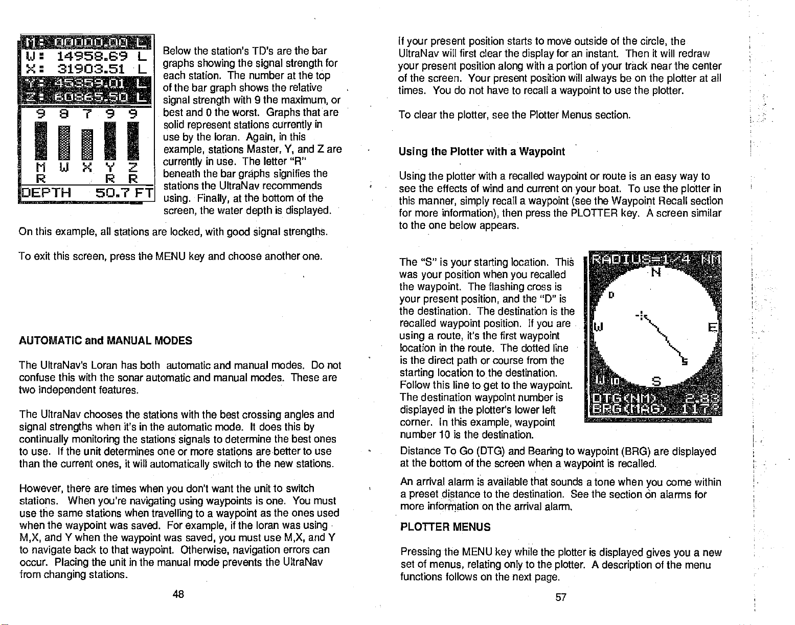
U 14958,29
X: 31903.51
L
L
98799
'HI'
MW<VZ
R RR
DEPTH 50.7 FT
On this
example,
all stations are
Below the
graphs showing
each station. The number at the
of the bar
signal strength
best and 0 the
solid
use
example,
currently
beneath the bar
stations the UltraNav recommends
using. Finally,
screen,
locked,
station's
graph
represent
the loran.
by
stations Master,
in use. The
the water
with
TD's are the bar
the
signal strength
top
shows the relative
with 9 the
worst.
stations
Again,
graphs signifies
the bottom of the
at
depth
good signal strengths.
maximum,
Graphs
currently
in
this
and Z are
'I,
letter "R"
is
displayed.
that are
in
the
for
or
If
your present position
UltraNav will first clear the
your present position along
of the screen. Your
times. You do not have to recall a
To clear the
Using
Using
see the effects of wind and current on
this
manner,
for more
plotter,
the Plotter with a
the
plotter
simply
information),
to the one below
starts to move outside of the
display
present position
see the Plotter Menus section
Waypoint
with a recalled
recall a
then
appears.
for an instant. Then it will redraw
with a
portion
waypoint
waypoint
waypoint (see
the PLOTTER
press
of
your
will
always
to use the
or route is an
boat. To use the
your
the
the
circle,
track near the center
be on the
Waypoint
key.
plotter
plotter.
easy way
plotter
Recall section
A screen similar
at all
to
in
To exit this
AUTOMATIC and MANUAL MODES
The UltraNav's Loran has both automatic and manual modes. Do not
confuse this with the sonar automatic and manual modes. These are
two
independent
The UltraNav chooses the stations with the best
signal strengths
continually monitoring
screen,
features.
when it's in the automatic mode. It does this
to use. If the unit determines one or more stations arebetterto use
than the current
However,
stations. When
use the same stations when
when the
and Y when the
M,X,
to
navigate
occur.
from
Placing
changing
ones,
there are times when
you're navigating using waypoints
waypoint
back to that
the unit in
stations.
PDF compression, OCR, web-optimization with CVISION's PdfCompressor
the MENU
press
the stations
it will
automatically
you
travelling
was saved. For
waypoint
waypoint. Otherwise, navigation
was
the manual
48
and choose another one.
key
signals
to determine the best ones
switch to the new stations.
don't want the unit to switch
to a
waypoint
example,
saved, you
mode
if the loran was
prevents
crossing angles
by
is one. You must
as the ones used
using•
must use
M,X,
errors can
the UltraNav
and
and Y
The "S' is
was
the
waypoint.
your present position,
the destination. The destination is the
recalled
using
location in the route. The doffed line
is the direct
starting
Follow this line to
The destination
displayed
corner. In this
number 10 is the destination.
Distance
at
the bottom of the screen when a
An arrival alarm is
a
preset
more information on the arrival alarm.
PLOTFER MENUS
Pressing
set of
functions follows on the next
your starting
your position
The
waypoint position.
a
it's the first
route,
path
location to the destination.
waypoint
in the
plotter's
example, waypoint
To Go
distance to the destination. See the section on alarms for
(DTG)
the MENU
menus,
relating
location. Thi
when
flashing
recalled
you
cross is
and the "D" is
If
are
you
waypoint
or course from the
to the
get
available that sounds a tone when
key
number is
lower left
and
Bearing
while
to
only
waypoint.
to
waypoint
the
plotter
the
plotter. A description
page.
57
waypoint (BRG)
is recalled.
is
displayed gives you
are
displayed
come within
you
of the menu
a new
Page 53

manual
Bearing
third
the
Heading (HDG)
screen.
heading (direction
Velocity
actual
Speed
averaged speed
are
boat
going
eight
Time
you
Water
PLOTTER
The
To
Waypoint
display, showing
recalled
making.
waypoint.
This
display
Made Good
toward the
speed
Over Ground
For
speedometer
head-on into a two
knots.
To Go to
to reach the recalled
is the
Depth
lets
plotter
the screen. The
destination if
waypoint
To use the
PLOTTER
this one
The
flashing
position.
or
path
is.a
compass
and
east,
radius
screen.
displayed
you
on a route.
or
plotter,
key.
appears.
cross
The solid line
have travelled.
you
west marked.
is
displayed
Your
the bottom
at
(BRG)
is the fifth item
shows
of
travel).
(VMG)
(SOG)
over
example,
says
waypoint
last item on the Nay
easily
you
plotter
are
simply press
A screen similar to
is
rose with
at the
present position
PDF compression, OCR, web-optimization with CVISION's PdfCompressor
is the
the direction
waypoint.
ground
if
you
knot
is the time the UltraNav
waypoint.
see
will also show
travelling
your present
is
your
north, south,
The circle's
top
of
to
on the
your
is
your
is the
that
you
your
are
travelling
current,
your
to a
the
track,
The circle
of the
is
screen.
the
56
then
Summary
course
your
OTO
(MM)
XTE(MI1)L
BRO
HOG (MiG)
tJMO
(MflG) 3270
(1(N)
SOG
(KN)
TTG
00:
OEPTH(FT)
at ten knots,
your
and direction
starting position
1 :32
but
over
speed
calculates it
Screen.
5,07
0.01
322°
16.4
16.6
you're
ground
will take
of travel on
and
is
To
mode,
press
"CHANGE SETUP"
the MENU
"AUTO OFF" label
of this
adjacent
disappear, switching
loran
The
the
which mode is in use.
See the "Position Screen"
MANUAL STATION
The UltraNav's
stations to
To
press
key adjacent
SETUP" label. Now
jacent
TIONS" label. The
low
M, Y,
TD's in reverse
also recommends
tions. To
press
stations. After each
an asterisk
station's
Press the
the
selecting
label.
loran screen.
crossing angles,
after a short wait.
the UltraNav
place
first
press
the
screen. Now
key
key
adjacent
two
to this label.
screen,
word "AUTO" or
of the
top
manually
position
use. This also locks
change
the MENU
to the
to the "SELECT
appears.
and Z are
the
In this
change
keys adjacent
""
letter, signifying
key
keys adjacent
the desired stations, press
activates
This
in the
the MENU
key.
Now
to the
label. Now
more times.
appears
press
The menus
to the
"MAN"
screen, showing __________
SELECTION
manual station selection
press
The
at the
top
the
key
will
last used
appear
section for
at
more information.
the unit in the manual
stations,
then
key,
"CHANGE
press
screen shown be-
example,
in
use
video).
using
stations, simply
key
displays
for all stations
to stations
your
If the stations
the unit
first
tile
press
the
LORAN STA-
(shown by
The UltraNav
these sta-
to the
is
pressed,
next to the
the
selection
should show
ad-
key
stations
the
desired
change.
that
you
W,
M,
you've
49
and Z were
the
and returns the UltraNav
chosen are locked
____________________
SELECT
UF1Efl
OJJ T F' UT
________________________
TFLIE
E.EAF 1iJO
_______________
4
CLEAP
feature
lets
cii
.I1
1
decide
you
mode.
:tJUOP4O,,O!J
14958.69
31903.51
4I5tCi
REC.
,6U6E55O
.1
EXIT
intend to
key adjacent
a
latitude/longitude position
use. in this
pressed.
_____
example,
After
to the "ENTER"
to a
with
good
which
Page 54

PRIMARY and ALTERNATE SOLUTIONS
The loran
normally
difference between the master and two other
Each time difference results in a line of
tion is the intersection of the lines of
determines its
position by
position.
position.
measuring
secondary
Your
present posi-
This is called
the time
stations.
a "fix'.
A mathematical formula in the loran receiver uses TD's to determine
the
latitude/longitude position.
in
position
baseline is an
latitude/longitude
imaginary straight
secondary station.)
on
fix
qualities
other side of the
the
give good
gitude
can be on either side of a
It's
possible
and
signal strengths,
Due to the nature
line
connecting
for
baseline
loran to lock onto the
the
from
of
loran, your
baseline.
the master and
show the latitude/lon-
but
your.present
position.
(The
each
stations,
Distance
indicator.
waypoint.
To Go
This is the distance from
When the UltraNav is first turned
(DTG)
is
displayed immediately
in nautical miles.
The
bearing
center left side of the screen. The
magnetic
To switch to
INGS" section.
The
waypoint you're currently using
of the
The cross track error
above the water
the
top
When
nautical miles.
to the
waypoint
(MBRG)
bearing display.
when the UltraNav is turned on for the
true
a
bearing display,
depth display.
of the screen
by
from
(XTE) displays
This is the same distance as shown at
the C.D.I.
the UltraNav is first turned
your present position displays
on,
below the C.D.I.
your present position
the distance is shown
on,
to the
at the
bearing
is shown
see the "SELECT TRUE BEAR-
for
navigation
at the bottom of the
display, only
the cross track error
in
degrees
first
shows to the
screen,
in
digital
numbers.
time.
right
displays
right
in
NAVIGATION
This screen shows all
numbers. To
UltraNav is in the Loran mode. The
Nowpress
following
All
(Note:
miles,
degrees magnetic,
when the UltraNav is turned on for
These two
side of the
positions (your present position
baseline)
They're usually
a
position
the
could be
important
far from
baseline,
only
to
the difference between the alternate and
a few
know
a loran.
are called the
far
apart, making
actual location.
your
miles,
or less. For this reason
primary
it
easy
your approximate position
and the one on the other
and alternate solutions.
to tell if the loran is
when
if
you're
alone,
initializing
However,
displaying
close to
primary
its
always
solution
or
using
the
very
Distance To Go
of the screen. This is the dis-
top
tance
to the last recalled
Cross Track Error
second item on this screen.
track error is the distance to the side
To switch
MENU
label. Now
key.
from the
Next,
press
primary
the
press
the
key adjacent
to
the alternate
key adjacent
to the "MORE" label.
solution,
to the
first
"CHANGE SETUP"
press
the
of
desired course.
your
50
PDF compression, OCR, web-optimization with CVISION's PdfCompressor
SUMMARY SCREEN
navigation
this
display
the
screen
key adjacent
appears.
screen,
to the "NAy SUMMARY SCREEN". The
features are in nautical
and knots
first
time.)
(DTG)
shows at the
waypoint.
is the
(XTE)
Cross
information
press
screen shown below
to a
waypoint
the MENU
OTO (NIl) 5.07
XTE(NM)L 1101
BRO(IIflG) 327°
HOG (MflG) 3220
0110 (1(N) 16.4
SOG (1(N) 16.6
00:18:32
OEPTH(FT) 87a9
55
in
twice while the
key
appears.
TTG
digital
Page 55

STEER INDICATOR
steer indicator
The
and
bearing
use this
The
navigation display
indicator
screen
0.1
to a
waypoint.
display.
display except
instead of the
0.0 O
III.,, 3i.l.yI
a
S
TEE R —
i
DT0c
I
(NM>
312°
0.02
65.8 FT
STEER INDICATOR
DISPLAY and NAVIGATION
display
shows
A
waypoint
shows the same
it shows the
steering
indicator.
steering,
cross
must be
information
present
position
N 32°
U
a*i
2
SCREEN
i1sZi1!
312°
DISPLAY
track
saved and recalled
as the steer
at the
_________
error,
distance
ot the
top
to
14.06'
810 2426'
424
.
2
65.8 FT
NAVIGATION SCREEN
This menu
the
key adjacent
ALTERNATE
UltraNav
after this selection.
screen with the
displayed,
new
position
doesn't show the
longitude position,
change
primary
The solution
UltraNav is
position
section
Check.your position
longitude. They
gate
To switch
above
PRIMARY SOLUTION".
appears.
to the
SOLUTION"
returns to a loran
If
latitude/longitude
the
lat/long
displays.
proper
you may
stations,
and alternate
screen.
then
currently
displayed
See the "Position
for more information.
against
should
normally.
back from the alternate
The
steps.
only
Finally, press
'SELECT
The
label.
screen
you're
using
will flash
until a
lithe unit
latitude/
have to
switching
try
solutions.
in use
at the
be the same.
difference
the
by
of the
top
the loran
AEJUStASP,
a
a
Di sPLAYED
_____________________
ALTEF
the
tLEAi
Screen"
after it
displays
If
use the loran
so,
to the
primary
is the menu label
solution, repeat
lJ S ITI 0 Fl
F
III TO'S
SELECT
SOLIJTIOtI
reads
NATE
a new latitude/
and navi-
the
"SELECT
The course
indicator screen.
miles
imaginary
tion.)
C.D.I. arrow
message
the boat to
The C.D.I.
for the
adjust
ample,
if
you
information on
deviation indicator
This shows the cross
are to the
you
line
For
example, you
points
also
get
range
first time. To set it to a different distance,
menu. The C.D.I.
ii the C.D.I.
are off course one
side of
between
drawn
to the 0.1 mark on the left side
appears
back on course.
is 0.1 nautical mile
range
setting
the C.D.I.
(C.D.l.)
your
your
are a tenth of a mile to the
STEER
range
is one
mile or more. See the ALARMS
PDF compression, OCR, web-optimization with CVISION's PdfCompressor
is at the
track error distance
desired
starting
>",
telling you
when the UltraNav
alarm are the same.
and
then the C.D.I.
mile,
alarm.
54
top
course.
location and the
which direction to steer
(The
use
steer
of the
in nautical
course
left of course
is an
destina-
of the scale.
is turned on
the CD]. alarm
For ex-
alarm will sound
section
lithe
A
for
SHOW TD'S
The UltraNav
on most screens.
the MENU
press
SETUP" label. Now
above
appears.
tion in
latitude/longitude.
shows either
To switch between
then
key,
press
In this
example,
To
latitude/longitude
press
the MENU
change
to the "POSITION DISPLAYED
to the last loran screen
revert
ences.
The menu will now read
Press the
To switch the
key adjacent
display
again, simply
"POSITION DISPLAYED
to this
latitude/longitude
the
key adjacent
once. The screen
key
the UltraNav
to
TD's, press
IN TD'S" label.
and show the
menu to
get
51
or time
position
repeat
latitude/longitude
differences
and
the "CHANGE
to
is
displaying
the
key adjacent
The UltraNav
in time
the above
IN LAT/LON".
(TD's)
TD's,
shown
the
posi-
will
differ-
steps.
displays.
first
Page 56

TRUE
and MAGNETIC POSITION
POSITION DISPLAY
Most
navigators
netic north. True north is the
longitude converge. Magnetic
point.
location in
Charts are
uses true north.
projection, you'll
use true
It lies several hundred
readings.
The UltraNav can
When it's turned on for the
switch to
true,
the "CHANGE SETUP" label. Now
"MORE" label two times. The menu shown below
example,
LECT TRUE BEARING"
last used
true.
Repeat
originally
MAGNETIC BEARING".
said "SELECT TRUE BEARING" now reads "SELECT
realize there is a difference between true and
Canada.
usually
magnetic
loran
laid out
If
you plot
either have to convert
display navigation
press
screen, showing
these
of the world. It's where all lines of
top
north is the location our
miles to the south of true
according
a course on a chart
very
the MENU
is in effect. Press the
label. The screen will clear and
to switch back to
steps
to a Mercator
magnetic readings
information in
first
time, magnetic
then
key,
all
press
press
navigation
the
key adjacent
magnetic.
using
the
key adjacent
information
compasses
north,
projection
which
the Mercator
to true or
magnetic
is used. To
key adjacent
or true.
to the
appears.
In this
to the "SE-
return
in
degrees
The menu that
mag-
at a
to the
to
The
position display
present position, heading, speed
ground, depth,
The GRI in use and the mode
matic or
the screen.
these is the
It shows
latitude/longitude
manual) display
Immediately
present position
your present position
shows
and status
or TD's. To the left
your
displays.
at the
beneath
display.
over
(auto-
top
in either
of the word "POSITION" is the ASF
indicator. It
are in use. On the far
primary/alternate
the unit is in the
appear
quality
crossing angles.
tion with caution. The
crossing angles.
when the fix
quality message
(0)
if the unit is in the alternate mode. In this same areais the fix
indicator. Fix
to
nine
shows when ASF's
only
is the
right
solution
primary mode,
If the fix.
The
quality
shows the fix
with zero the worst and nine the best.
(9),
display.
the letters "PAl"
quality
is not usable. A number
is a measure of the
quality
displayed position
position display
is
quality's
AUTO
RSF
FtELrT
H 24°33.37
IJi3i°4363
rix IS 6000(8)
of
135°
23a8 KN
E1EFTH
appear.
lines
displayed
will
and
to the
range
56.8
right
If
use the
poor,
can
flashes the last known
value, It's
GRI :7980
'iN
Pr
I
T
"ALT"
of
position's
informa-
with
vary
poor
position
fix
of the
is from zero
JJ UI tJ
LNME
H 32° 14.06'
LI 81° 24.36'
2:D:....:(i.iF!i
Remember,
display
4.24
a
C..
H:TSF!G.
312°
TPUE
BESRItTG
52
.4*TFi.'
.Tl,JPt#.
1
<iqji )•
0.03
i
)..
65.8 FT I
TRUE BEARING
(TBRG)
Beneath the
is
travelling. Speed
regardless
at ten knots
elling
over
ground
distance in a
an accurate
gives
The last.
PDF compression, OCR, web-optimization with CVISION's PdfCompressor
do not use the loran for
flashes. Find and
fix
quality message
over
ground (SOG)
of the
speedometer reading.
directly against
is
straight
display
knots. You will
eight
line before the SOG feature
reading.
on this screen is the
correct the
the
unit.
is
your heading,
a two knot
typically
53
navigation
problem
when the
before
navigating
or direction the boat
shows
For
example,
current,
need to travel some
digital depth display.
actual
your
if
you're
then
"settles down" and
position
with
speed,
trav-
your speed
 Loading...