

Page 1
Aerosoft
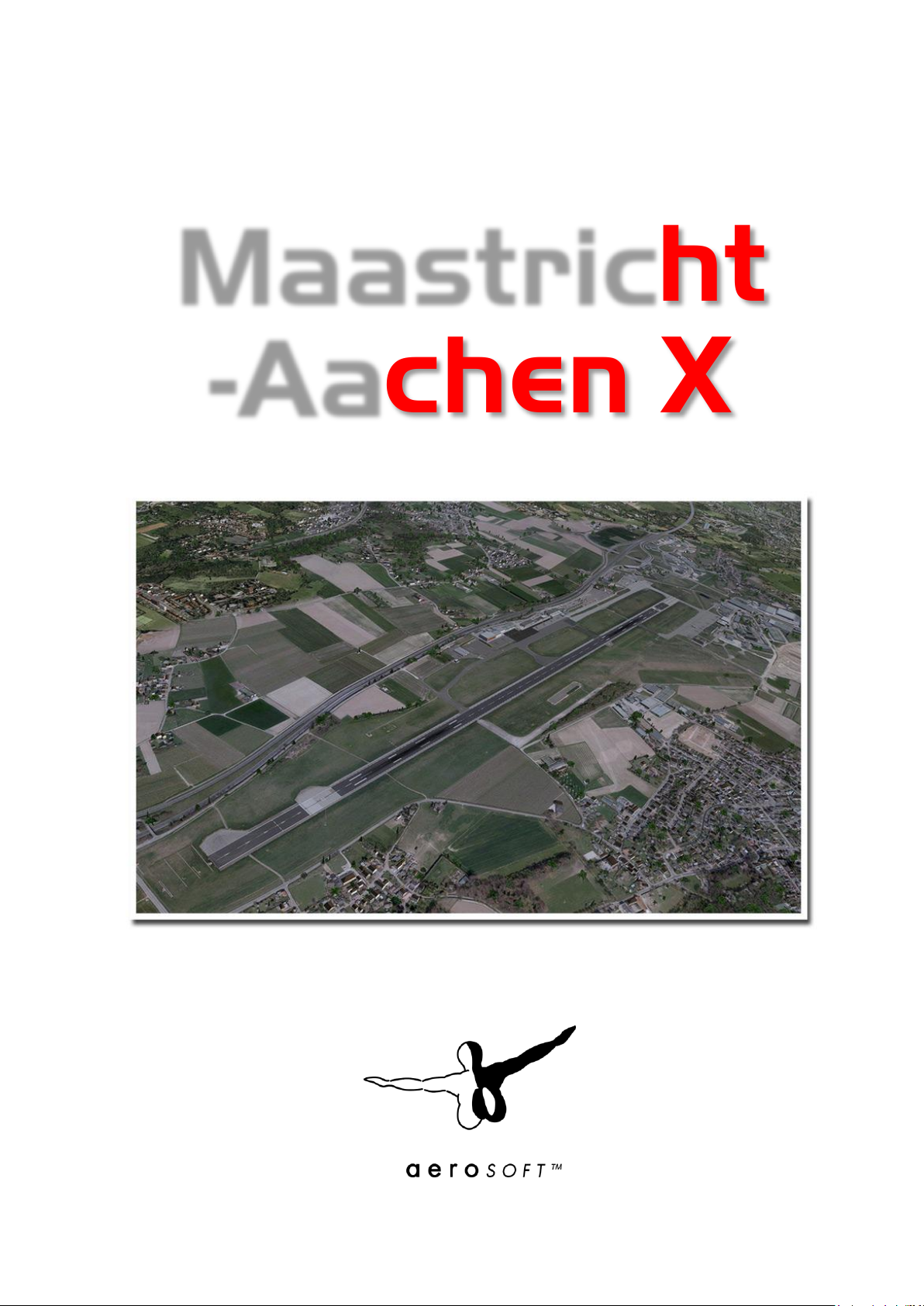
Maastricht
-Aachen X
Page 2
Aerosoft Maastricht-Aachen X 1.01 Manual
CO N TEN TS
INTRODUCTION .................................................................................................................................................... 2
COPYRIGHTS ......................................................................................................................................................... 2
CREDITS ................................................................................................................................................................ 3
SYSTEM REQUIREMENTS ...................................................................................................................................... 3
CONTACT SUPPORT .............................................................................................................................................. 3
INSTALLATION AND REMOVAL ............................................................................................................................. 3
FINDING THE AIRPORT ......................................................................................................................................... 4
CHARTS ................................................................................................................................................................. 4
DISPLAY SETTINGS ................................................................................................................................................ 4
GRAPHICS MENU .................................................................................................................................................. 4
SCENERY SETTINGS ............................................................................................................................................... 5
TRAFFIC ................................................................................................................................................................ 6
AIRCRAFT AND WEATHER SETTINGS .................................................................................................................... 7
INFORMATION FOR MAASTRICHT - AACHEN AIRPORT ......................................................................................... 8
RADIO COMMUNICATION FREQUENCIES ............................................................................................................. 8
RUNWAYS ............................................................................................................................................................. 8
F.A.QS. .................................................................................................................................................................. 9
Page 1 of 10
Page 3

Aerosoft Maastricht-Aachen X 1.01 Manual
IN TRODUCTION
Maastricht Aachen airport has its roots in the Second World War when the US Engineer Corps created
Advanced Landing Ground Y-44 as a front line airport for fighter bombers and recce aircraft. Directly after the
war is was still busy as the road network of the Netherlands was severely damaged. But when car travel
became easier it was decided to keep the airport open and to turn it into a regional airport. It was steadily
upgraded and EUROCONTROL decided to us the airport as its base. It’s now doing very well with growing
passenger and freight amounts.
The moment the low cost airlines started to operate the airport got a huge boost. Located close to the Belgium
and German border and close to many major cities it attracted companies like RyanAir and GermanWings. To
increase the multinational idea the airport was renamed from “Vliegveld Beek” to Maastricht-Aachen Airport.
With good success as more than half the passengers are now German.
CO P YRIGHTS
The manual, documentation, video images, software, and all the related materials are copyrighted and cannot
be copied, photocopied, translated or reduced to any electronic medium or machine legible form, neither
completely nor in part, without the previous written consent of AEROSOFT. THE SOFTWARE IS FURNISHED «AS
IS» AND IT DOES NOT COME FURNISHED WITH ANY GUARANTEE IMPLICIT OR EXPRESS. THE AUTHOR DECLINES
EVERY RESPONSIBILITY FOR CONTINGENT MALFUNCTIONS, DECELERATION, AND ANY DRAWBACK THAT
SHOULD ARISE, USING THIS SOFTWARE.
Copyright © 2012 AEROSOFT/ Andras Kozma. All rights reserved. Microsoft Windows, and Flight Simulator are
registered trademarks or trademarks of Microsoft Corporation in the United States and/or other Countries. All
trademarks and brand names are trademarks or registered trademarks of the respective owners. Copyrights
are serious stuff. If you find any pirated copies of this software please notify us at support@aerosoft.com. We
will make sure reports of copyrights violation are rewarded.
Aerosoft GmbH
Lindberghring 12
D-33142 Büren
Germany
www.aerosoft.com
Page 2 of 10
Page 4

Aerosoft Maastricht-Aachen X 1.01 Manual
CREDITS
Concept: Aerosoft
Programming/ modeling: Andras Kozma
Project Management: Mathijs Kok (Aerosoft)
Manual, documentation: Mathijs Kok (Aerosoft)
Installer: Andreas Mügge
Testing: Several good folks who will all be getting a copy
Special thanks to Mark Honing for the detailed photo shoot of the airport!
SYS TEM REQUIR EM E N TS
Intel Core 2 Duo E6850 CPU (Core 2 Quad advised)
2 GB RAM
Direct X 9 compatible Graphics Card with minimal 512 MB
Microsoft FSX (with SP2 or Acceleration), Lockheed Martin Prepar3D
Windows XP, Windows VISTA, Windows 7 (fully updated)
Adobe Acrobat® Reader 8 minimal to read and print the manual
(1)
(1)
Available for free, download at: http://www.adobe.com/prodindex/acrobat/readstep.html
CO N TACT SUPPO R T
Support for this product is done by Aerosoft. We prefer to do support on the support forum for one simple
reason, it is fast and efficient because customers help customers when we are sleeping.
Aerosoft forums: http://www.forum.aerosoft.com/
We feel strongly about support. Buying one of our products gives you the right to waste out time with
questions you feel might be silly. They are not.
IN ST A LLATION AND R EM OVAL
Installation is simple. Unzip the file that you downloaded and start the exe file you downloaded and follow the
instructions on your screen. Make sure FSX (or FS2004) is closed and we do advise you to reboot your system
before installing. Make sure you are logged on as Administrator on the machine! After installing it can help to
defragment your hard disk (but do not do so if you have installed it on a SSD). Do note that the files are
personalized on installation. When you share them with others you also share personal details.
After installation has finished the Aerosoft Launcher will start and it will be installed (or updated). See
Appendix A for a detailed explanation.
Removal should never be done manually but only using the software removal applet you will find the Windows
Control panel.
Page 3 of 10
Page 5
Aerosoft Maastricht-Aachen X 1.01 Manual
FINDING THE A IR P O RT
You will find the airport using either the airport name (Maastricht Aachen), the city name (Maastricht) or the
airport ID (EHBK).
CH ARTS
We have added the most current charts for this airport to this manual as Appendix B. Please note you can
always find them at http://www.ais-netherlands.nl/aim/111201-120112/eAIP/html/index-en-GB.html. Of
course the charts in this manual should never be used for real aviation!
DISPLAY SETT I N G S
In order to change your scenery settings, go to Settings -> Display. All settings that are important to see this
scenery correctly are marked in red and need to be shown. All other settings are to your own liking.
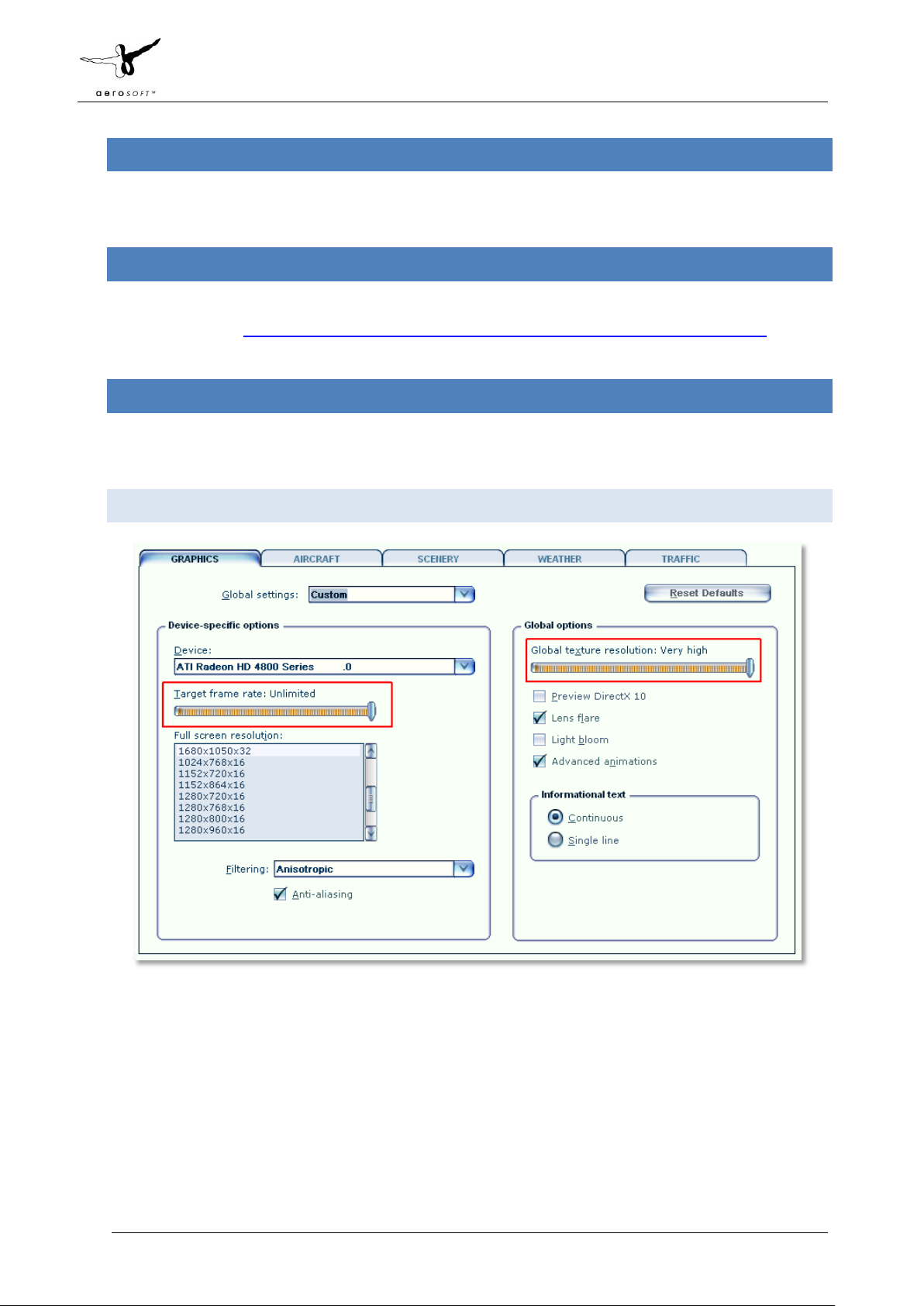
GRAPHICS M EN U
We advise to keep Target frame rate set to Unlimited when your hardware is not very fast. If you see
your framerate wildly fluctuating and over 50 fps we advise you to limit the framerates to 40. This will
allow FSX to calculate a few things in advance.
Global texture resolution has to be to Very high.
As this project is easy on FPS you most likely will be able to activate Lens flare that adds some nice
sun effects.
Page 4 of 10
Page 6
Aerosoft Maastricht-Aachen X 1.01 Manual
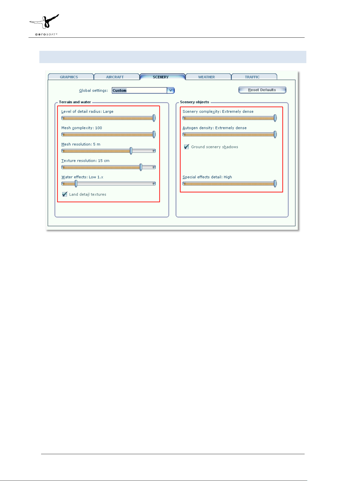
SCENERY SE TT I N GS
Mesh is important for this scenery. Set Mesh Complexity to 100 and Mesh resolution to 5 meter.
Settings below 5 meters will cause problems.
Texture resolution should be at 15 cm or less to get the best resolution of the textures.
Special effects details should be on High to see all the special animations.
For best results we recommend to set Autogen Density to Normal.
Water effects are best set very low because there is no pure blue tropical water around.
Also, do make sure that ground scenery shadows box is left ticked, since all 3D objects have built-in
shadows for better performance
Page 5 of 10
Page 7
Aerosoft Maastricht-Aachen X 1.01 Manual
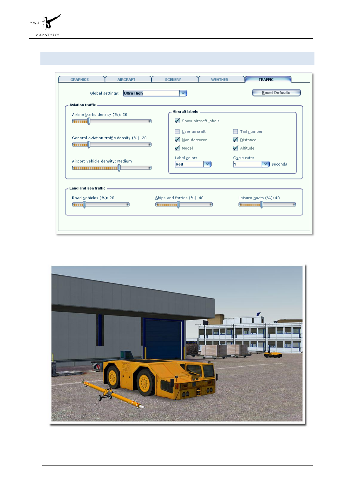
TR AF F IC
Traffic settings as shown are advised. This will make the project look best and will avoid problems.
Page 6 of 10
Page 8
Aerosoft Maastricht-Aachen X 1.01 Manual
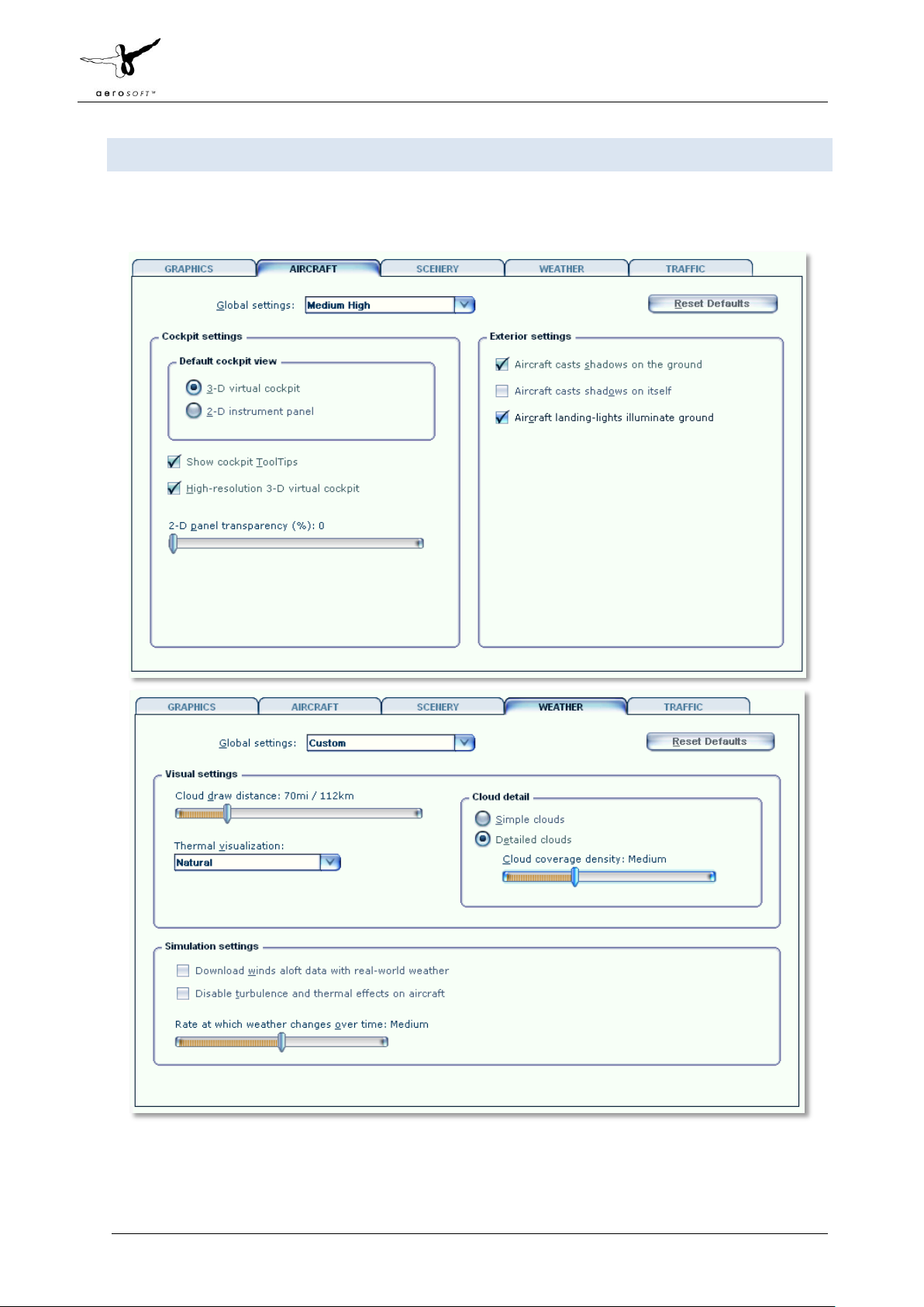
AIRCRAFT A N D W E AT HER SETTINGS
Aircraft and weather settings are not very important for a scenery but for completion we added the settings
our testers found to be most suitable. Note that 3d clouds can have a profound effect on frame rate.
Page 7 of 10
Page 9

Aerosoft Maastricht-Aachen X 1.01 Manual
IN FO RMATION FO R MAASTRICHT - A A CH EN AIRPORT
Country: The Netherlands
City: Maastricht
ICAO ID: EHBK
IATA ID: MST
Time: UTC+1(+2DT)
50°54′57″N 005°46′37″E
Elevation: 375 feet (114 meters) (note that things do not go much higher in the Netherlands!)
Type: Civil
RADIO COMMUN I C A TI ON F R EQ U ENCIES
Beek Tower 119.475 MHz
Beek Delivery 121.825 MHz
Approach 123.975 MHz
ATIS 124.575
RUNWAYS
Runway 03
Surface ASP: Asphalt,
Heading 032.62°
Latitude 50° 54' 06.61" N
Longitude 005° 45' 36.18" E
Elevation (ft) 365.0
Slope 0.0°
Landing Distance 8202 feet
Takeoff Distance 8202 feet
CL - Centerline Lighting System
HIRL - High Intensity Runway Lights
REIL - Runway End Identifier Lights
PAPI - Precision Approach Path Indicator
Runway 21
Surface ASP: Asphalt
Heading 216.63°
Latitude 50° 55' 14.79" N
Longitude 005° 46' 45.22" E
Elevation (ft) 364.0
Slope 0.0°
Landing Distance 8202 feet
Takeoff Distance 9022 feet
HIRL - High Intensity Runway Lights
REIL - Runway End Identifier Lights
A - ALSF-2
CL - Centerline Lighting System
Page 8 of 10
Page 10

Aerosoft Maastricht-Aachen X 1.01 Manual
F.A.QS.
Q: Is this add-on DX10 compatible?
A: No, the high resolution textures will cause problems.
Q: Is this add-on compatible with other add-ons in the area?
A: We have tested this with the NL2000 project and found no problems. Do note the we use a color adjusted
aerial image that has a more muted color then the rather vivid images used by NL2000.
Q: There seem to be issues with the airport lighting at day/night transitions. Is this normal?
A: No but it isn't curable. FSX sometimes has its own ways of switching day/night textures. If you face any
texture or scenery problems, open the scenery library and click OK (or use the "refresh scenery" shortcut) to
reload scenery and textures.
Page 9 of 10
Page 11

332.750
GP
TWR
472
LOC
RWY 03/21 2500 x 45 m
PAPI
Ceilometer
E2
T
W
W3
W4
W
basin
basin
basin
BKN 111.550
LOC
BKZ 111.550
332.750
GP
BEEK /
50°55’21’’N
CH.52
005°46’47’’E
Y
(111.55) /
BKN & BKZ
03
21
ARP
50°54’57’’N
005°46’37’’E
E1
W1
Test run site
Fire test site
PAPI
DISPLACED THR
250 m
ELEV 365 FT AMSL
DISPLACED
THR 250 m
ELEV 371
FT AMSL
Anemometer
Anemometer
2500m
2500m
See
Note 3
See
Note 2
E
E1
W1
E
332.750
GP
E2
W
W3
W4
See
Note 1
DO NOT USE
DO NOT USE
Car park
A - APRON
B - APRON
C - APRON
S - APRON
RWY
THR
TORA
ASDA
TODA
LDA
m
m
m
m
005°45’36.18’’E
2500
005°46’38.32’’E*
DIMENSIONS (m)
RUNWAY
STRIP
2500x45
2870x300
COORDINATES
SURFACE
ASPH
ASPH
PHYSICAL CHARACTERISTICS
DECLARED DISTANCES
BEARING
STRENGTH
DIRECTION
GEO
03
21
2500x45
2870x300
PCN 71/F/C/X/T
2500
2500
2650
2500
PCN 71/F/C/X/T
2500
2500
2750
50°55’07.98’’N*
50°54’06.61’’N
TORA
ASDA
TODA
1050
1200
1600
RWY
TWY
1960
1225
03
21
21
21
W4
E2
W3
W4
1050
1960
2210
1600
1850
1225
1475
INTERSECTION TAKE-OFF
See EHBK AD 2.23
W3A
W3
W4A
W4
W1
W1A
W2
E1
E2
E2A
E1A
HOTSPOT
CAUTION:
DO NOT CROSS
THE HOLDING POSITION
MARKINGS WITHOUT
A CLEARANCE.
032.62°
212.63°
AIP NETHERLANDS
ELEVATIONS IN FEET AMSL
HOTSPOT
CAUTION:
DO NOT CROSS
THE HOLDING POSITION
MARKINGS WITHOUT
A CLEARANCE.
W3A
W4
W4A
W4
W2
W3
See
Note 1
W3
INSETS
SCALE 1 : 7 500
W1A
W
GP
332.750
ACL: APRON 375
MAASTRICHT AACHEN AIRPORT
AERODROME CHART
AD ELEV 375 ft AMSL
W1
W1
E2
TWR
472
E2
E2A
A - APRON
E1
E1
E1A
E
W
Car park
W3
Anemometer
GP
332.750
BEEK /
(111.55) /
50°55’21’’N
B - APRON
PAPI
BKN & BKZ
CH.52
005°46’47’’E
E2
005°46’37’’E
Y
21
DISPLACED
THR 250 m
ELEV 371
FT AMSL
ARP
50°54’57’’N
PRECISION APPROACH
LIGHTING SYSTEM
LOC
BKZ 111.550
basin
W1
E1
C - APRON
T
CAT I/II/III
E
S - APRON
AD 2.EHBK-ADC
ANNUAL RATE
OF CHANGE 6’ E
basin
02 JUL 09
VAR 1° W (2005)
Test run site
Fire test site
Ceilometer
Anemometer
GP
332.750
PAPI
DISPLACED THR
250 m
ELEV 365 FT AMSL
2500m
See
Note 3
PRECISION APPROACH
LIGHTING SYSTEM
CAT I
03
See
Note 2
2500m
BKN 111.550
LOC
© Air Traffic Control the Netherlands
DO NOT USE
W4
basin
RWY 03/21 2500 x 45 m
metres
0
100
feet
0
ELEVATIONS IN FEET AMSL
DIRECTION
RWY
GEO
032.62°
03
212.63°
21
INSET
See
Note 3
DO NOT USE
SCALE 1 : 12 500
300 400
200
500
DIMENSIONS (m)
RUNWAY
2500x45
2500x45
1000
PHYSICAL CHARACTERISTICS
STRIP
2870x300
2870x300
NOTES :
1.
See
Note 2
2.
3.
LEGEND
TAXIWAY (with taxiline) / APRON / PLATFORM
TAXIWAY NAME
W
VDF
119.475
119.700
121.500
123.975
1500
SURFACE
ASPH
ASPH
For TWY W a wingspan restriction
of 45 metres is applicable.
Start position RWY 03
(White dashed transverse marking)
See EHBK AD 2.23.
Turnpad RWY 03
For jet ACFT: powersetting
below breakaway thrust.
500
THR
COORDINATES
50°54’06.61’’N
005°45’36.18’’E
50°55’07.98’’N*
005°46’38.32’’E*
RWY HOLDING POSITION MARKING, PATTERN A
RWY HOLDING POSITION MARKING, PATTERN B
H24 FIXED STOPBAR
H24 SWITCHABLE STOPBAR
TAXIWAY LIGHT BIDIRECTIONAL (GREEN)
TAXIWAY/TURNPAD LIGHT UNIDIRECTIONAL (GREEN)
TAXIWAY LIGHT UNIDIRECTIONAL (YELLOW)
APRON LIGHT
WIND DIRECTION INDICATOR
RVR
BUILDING
WATER
ROAD
PCN 71/F/C/X/T
PCN 71/F/C/X/T
BEARING
STRENGTH
INTERSECTION TAKE-OFF
RWY
03
21
21
21
( )
DECLARED DISTANCES
TODA
TORA
m
m
2500
2500
2500
2500
See EHBK AD 2.23
TWY
TORA
W4
1050
1960
E2
1600
W3
1225
W4
AIRAC AMDT 07/09
ASDA
2650
2750
TODA
1050
1960
1600
1225
( )
LDA
m
m
2500
2500
ASDA
1200
2210
1850
1475
CHANGE: RWY GEO direction, editorial.
Page 12

MAASTRICHT AACHEN
AD 2.EHBK-APDC
AIP NETHERLANDS INS REFERENCE CHART 28 AUG 08
005°46’00’’E 005°47’00’’E
50°55’24’’N
50°55’18’’
005°46’06’’ 005°46’12’’ 005°46’18’’ 005°46’24’’ 005°46’30’’ 005°46’36’’ 005°46’42’’ 005°46’48’’ 005°46’54’’
B- APRON
7
6
5A
N
4
3
CARGO WEST
2
1
5
6
7
5A
5
4
3
2
1
W1
21
50°55’24’’N
50°55’18’’
E1
50°55’12’’
C5
GENERAL
AVIATION
C4
50°55’12’’
50°55’06’’
50°55’00’’
AIRPORT AUTHORITY
50°54’54’’
HANGAR 3
FUEL
50°54’48’’
50°54’42’’
TWR
4
4
3
W4
PAX TERMINAL
2
2
3
1
A-APRON
1
W3
W
see note
E2
ARP
50°54’57’’N
005°46’37’’E
E
C1
C-APRON
C3
C2
MAINTENANCE
50°55’06’’
S-APRON
T
50°55’00’’
50°54’54’’
50°54’48’’
50°54’42’’
50°54’36’’
DO NOT USE
50°54’30’’
NOTE:
For TWY W a wingspan
restriction of 45 metres is applicable
50°54’24’’N
005°46’00’’E 005°47’00’’E
© Air Traffic Control the Netherlands
005°46’06’’ 005°46’12’’ 005°46’18’’ 005°46’24’’ 005°46’30’’ 005°46’36’’ 005°46’42’’ 005°46’48’’ 005°46’54’’
AIRAC AMDT 09/08
50°54’36’’
50°54’30’’
50°54’24’’N
CHANGE: General, Cargo and Maintenance apron renamed into A, B and C-apron, S-apron and Taxiway T added, Taxiway P deleted, editorial.
Page 13

1000
AIP NETHERLANDS
MAASTRICHT AACHEN
INSTRUMENT APPROACH CHART
RWY 03
ILS CAT I/DME
GP INOP
and BEMTI 1A
APPROACH
AD 2.EHBK-IAC-03.1
28 JUL 11
APP 123.975
(TAR)
128.350
119.475
TWR
119.700
124.575
ATIS
121.500
GP
LOC 111.550 BKZ
DME
VAR 1° W (2005)
51°
00’
N
B E L G I U M
50°
50’
N
SCALE 1 : 250 000
km
Beek
Dutch MIL outside OPR HR
Beek
Reg. Guard
Maastricht
General Emergency
332.750
BKZ
CH.52
Y
AD ELEV 375
(14.2 MAS)
MAX 210 KT IAS
Approach
Tower
IF
EH302
7.4 BKZ
Information
(111.55) /
50°55’21’’N
657
BRUSSELS FIR
BEEK /
CH.52
005°46’47’’E
033°
FAF
EH303
5.8 BKZ
(12.7 MAS)
1800 AMSL
GP INOP
AMSTERDAM FIR
BKZ
Y
EH310
4.0 BKZ
(11.0 MAS)
1230 AMSL
305°
4.9
10 NM
614
770
617
591
640
591
21
THR 03
1.4 BKZ
(8.7 MAS)
MAS 220
12.3 MAS
2000 AMSL
BEMTI 1A APPROACH
033°
3000
1 min
8.5 MAS
3000 AMSL
MAX 220
KT IAS
IAF
185°
751
GULL /
50°48’26’’N
213°
51°01’10’’N
MAS 220
GUL- 383.5
005°53’44’’E
L / NW - 373
005°52’42’’E
MAASTRICHT /
108.6 /
50°58’19’’N
10 NM
CH.23
005°57’38’’E
CAUTION:
Notice the short distance between the IF and the FAF
available for LOC-course interception.
NOTES:
Navigation in the initial and intermediate approach segment
is primarily based on rader vectors provided by ATC.
Given speeds are mandatory.
The approach via BEMTI only at ATC discretion
(see page EHBK AD 2.22 paragraph 2.8).
Given EH points beyond the FAF must be considered to be
supplementary information.
DME BKZ reads 1.4 at THR 03.
Execution of the complete procedure via L-NW depicted
by at ATC discretion or in case of COM-failure.
SCHINVELD
MAS
X
925
G
G E R M A N Y
LANGEN FIR
AMSTERDAM FIR
ATC DISCRETION
BEMTI
3000 AMSL
0
0NM
05° 40’E 05° 50’ 06° 00’ 06° 10’E
5105
2421
1000
DO NOT DESCEND BELOW THE DESCENT PROFILE
GIVEN ALTITUDES TO BE CONSIDERED AS MNM ALT
EH302
7.4 BKZ
78
DIST RELATED TO DME BKZ
GS IN KT
VERTICAL SPEED
ACFT
CAT
A
B
C
D
D
L
TAKE-OFF
LANDING
DAY:
DAY:
CAT I
Press Alt
(148)
513
523
(158)
(168)
533
(178)
543
(188)
553
CEILING AND VISIBILITY MINIMA
NA
7.4
GP INOP
MAPt: THR
720
© Air Traffic Control the Netherlands
TRANSITION LEVEL BY ATC
TRANSITION ALTITUDE 3000 ft AMSL
1545
425 ft/min
CIRCLING
(520)
890
940
(570)
1170
(800)
EH310
4.0 BKZ
MNM 1230
AMSL
GP INOP
3.0° (5.2%)
NA
MAPt: THR 03
1.4 BKZ
910
GP INOP
590
033°
03
0
12345
1.4
530 ft/min
EH302 50°49’08’’N 005°40’35’’E
EH303 50°50’27’’N 005°41’54’’E
EH310 50°51’58’’N 005°43’26’’E
BEARINGS ARE MAGNETIC
DISTANCES IN NM
ALTITUDES AND ELEVATIONS
IN FEET
1. Missed approach:
- Track 033° MAG and climb to 2000 ft AMSL.
- Inform ATC.
2. Missed approach in case of communication failure:
- Track 033° MAG to L-NW and climb to 3000 ft AMSL;
- Cross L-NW at 3000 ft AMSL and execute
BKZ
ILS RDH 50 ft
21
02345
635 ft/min 745 ft/min
the instrument approach procedure again.
850 ft/min 955 ft/min
MSA BASED ON MAS VOR/DME
2100
055°
2600
3300
015°
IF
FAF
EH303
5.8 BKZ
MNM 1800
AMSL
GP INOP
033°
6
5.8
60 80 100 120 140 160 180
320 ft/min
(OCH)OCA ELEV THR 03: 365.4 ft
(360)
NIGHT:
NIGHT:
AIRAC AMDT 08/11
THR ELEV 365
281°
CHANGE: OCA/OCH, ACFT CAT DL added, editorial.
Page 14

1000
1000
1000
1500
AIP NETHERLANDS
AIP NETHERLANDSAIP NETHERLANDS
APP 123.975
APP 123.975
(TAR)
(TAR)
128.350 Dutch MIL outside OPR HR
128.350 Dutch MIL outside OPR HR
119.475
119.475
TWR
TWR
119.700
119.700
124.575
124.575
ATIS
ATIS
121.500
121.500
332.750
GP
LOC 111.550 BKZ
CH.52
DME
VAR 1° W (2005)
Approach
Approach
Beek
Beek
Beek
Beek
Tower
Tower
Reg. Guard
Reg. Guard
Maastricht
Maastricht
General Emergency
General Emergency
BKZ
Y
AD ELEV 375
B E L G I U M
5°20’E
5°20’E
MAASTRICHT AACHEN
RNAV INSTRUMENT APPROACH CHART
RNAV INSTRUMENT APPROACH CHART
Information
Information
MAASTRICHT AACHEN
BUDEL
BUDEL
AMSTERDAM FIR
AMSTERDAM FIR
BRUSSELS FIR
BRUSSELS FIR
10 NM
L / NW - 373
L / NW - 373
51°01’10’’N
51°01’10’’N
BKZ
BEEK /
BKZ
5°30’
5°30’
BEEK /
50°55’21’’N
50°55’21’’N
MAX 210 KT IAS
Y(111.55) /
CH.52
Y(111.55) /
CH.52
005°46’47’’E
005°46’47’’E
657
IF
EH302
7.4 BKZ
OLNO 1A
OLNO 1A
TRANSITION
TRANSITION
5°40’
5°40’
FAP
EH303
5.8 BKZ
1800 AMSL
RWY 03
OSGOS 1A
TRANSITION
MAX 220 KT IAS
MAX 220 KT IAS
005°52’42’’E
005°52’42’’E
770
770
640
640
591
591
21
THR 03
1.4 BKZ
033°
033°
EH310
4.0 BKZ
1230 AMSL
305°
5
12
12
OLNO
015°
015°
VOR/DME
BAXIM 1A, BOBMO 1A, MODRU 1A, OLNO 1A,
OSGOS 1A and RUMER 2A TRANSITIONS
FROM
RUMER (IAF)
RUMER 2A
22
TRANSITION
ILS CAT I / DME
178°
SOPVI
16.8 MAS 352.9
489
489
033°
033°
591
591
751
214°
50°48’26’’N
50°48’26’’N
IAF
BERIR
MNM 3000 AMSL
5°50’
5°50’
4
400
574
8
3000
1 min
13
190°
EH309
MNM 3500 AMSL
5
GULL /
GUL- 383.5
GULL /
GUL- 383.5
173°
IAF
OSGOS
12.8 MAS 352.9
181°
BOBMO
BOGRU
17
198°
005°53’44’’E
005°53’44’’E
479
630
630
BOBMO 1A
TRANSITION
IAF
50°58’19’’N
50°58’19’’N
SCHINVELD
GG
14
14
10
10
220°
220°
226°
226°
925
10 NM
1000
6°00’
6°00’
416
416
MAASTRICHT /
MAASTRICHT /
108.6 /
108.6 /
BAXIM
1000
AD 2.EHBK-IAC-03.2
NOTES:
NOTES:
ATC may deviate from the transitions
by radar vectors.
ILS / DME must be available.
DME BKZ reads 1.4 at THR 03
Altitudes / Speeds:
Altitudes / Speeds:
During the transition, descend to or
maintain a level as instructed by ATC.
MAX 250 KT IAS below FL 100.
When cleared for a BERIR approach RWY 03 :
Continue via the transition.
Descent path at pilot’s discretion.
The minimum altitudes shall be respected.
The published speeds are mandatory.
Execute the ILS approach RWY 03.
AMSTERDAM FIR
AMSTERDAM FIR
LANGEN FIR
G E R M A N Y
MAS
MAS
X
X
CH.23
CH.23
005°57’38’’E
005°57’38’’E
MODRU 1A
IAF
TRANSITION
MODRU
BAXIM 1A
BAXIM 1A
IAF
TRANSITION
TRANSITION
6°10’
6°10’
SCHWALMTAL
SCHWALMTAL
28 JUL 11
1000
1500
6°20’E
6°20’E
51°
51°
20’
20’
N
N
51°
51°
10’
10’
51°
51°
00’
00’
50°
50°
50’
50’
N
N
DO NOT DESCEND BELOW THE DESCENT PROFILE
GIVEN ALTITUDES TO BE CONSIDERED AS MNM ALT
IAF
BERIR
3000 or ATC discretion
10
DIST RELATED TO DME BKZ
GS IN KT
VERTICAL SPEED
ACFT
CAT
A
B
C
D
D
L
TAKE-OFF
LANDING
CAT I
Press Alt
(148)
513
523
(158)
(168)
533
(178)
543
(188)
553
CEILING AND VISIBILITY MINIMA
DAY:
DAY:
NA
GP INOP
NOT ALLOWED
© Air Traffic Control the Netherlands
TRANSITION LEVEL BY ATC
TRANSITION ALTITUDE 3000 ft AMSL
1. Missed Approach:
IF
305°
60 80 100 120 140 160 180
320 ft/min
EH302
7.4 BKZ
7.4
425 ft/min
(OCH)OCA ELEV THR 03: 365.4 ft
(OCH)
CIRCLING
890
940
1170
NIGHT:
NIGHT:
033°
(520)
(570)
(800)
FAP
EH303
5.8 BKZ
1800
6789
6789
5.8
THR 03
EH302 50°49’08’’N 005°40’35’’E
EH303 50°50’27’’N 005°41’54’’E
EH309 50°50’14’’N 005°51’13’’E
EH310 50°51’58’’N 005°43’26’’E
BEARINGS ARE MAGNETIC
DISTANCES IN NM
NA
ALTITUDES AND ELEVATIONS
IN FEET
1545
3° (5.2%)
530 ft/min
50°54’07’’N
EH310
4.0 BKZ
1230
910
620
03
2345
345
345
345
2
635 ft/min 745 ft/min
005°45’36’’E
1.4
- Track 033° MAG and climb to 2000 ft AMSL.
Inform ATC.
2. Missed Approach in case of communication failure:
- Track 033° MAG to NW and climb to 3000 ft AMSL;
- Cross NW at 3000 ft AMSL and execute
the instrument approach procedure as depicted on
chart AD 2.EHBK-IAC-03.1.
BKZ
BKZ
033°
21
1
NM 0
ILS RDH 50 ft
850 ft/min 955 ft/min
MSA BASED ON MAS VOR/DME
2100
055°
2600
015°
3300
AIRAC AMDT 08/11
THR ELEV 365
54321
54321
281°
CHANGE: OCA/OCH, ACFT CAT DL added, editorial.
Page 15

1000
AIP NETHERLANDS
MAASTRICHT AACHEN
INSTRUMENT APPROACH CHART
RWY 03
NDB / DME
NW / BKZ or BKN
and BEMTI 1A
APPROACH
AD2.EHBK-IAC-03.3
05 MAY 11
APP 123.975
(TAR)
128.350
119.475
TWR
119.700
124.575
ATIS
121.500
DME 111.550
VAR 1° W (2005)
51°
00’
N
B E L G I U M
50°
50’
N
SCALE 1 : 250 000
km
Beek
Dutch MIL outside OPR HR
Beek
Reg. Guard
Maastricht
General Emergency
in Amsterdam FIR
BKZ or BKN
BKZ or BKN
CH.52
Y
AD ELEV 375
(14.2 MAS)
MAX 210 KT IAS
Approach
Tower
Information
BEEK /
(111.55) /
50°55’21’’N
BRUSSELS FIR
AMSTERDAM FIR
BKZ or BKN
CH.52
Y
005°46’47’’E
10 NM
THR 03
1.4 BKZ
(8.7 MAS)
640
770
21
617
591
614
591
033°
MAX 220
3000
1 min
KT IAS
IAF
751
185°
213°
L / NW - 373
51°01’10’’N
50°58’19’’N
MAS 220
005°52’42’’E
MAASTRICHT /
108.6 /
CH.23
005°57’38’’E
NOTES:
Navigation in the initial and intermediate approach segment
is primarily based on radar vectors provided by ATC.
Given speeds are mandatory.
The approach via BEMTI only at ATC discretion
(see page EHBK AD 2.22 paragraph 2.8).
DME BKN may substitute DME BKZ.
Both DME BKZ and BKN read 1.4 at THR 03.
Execution of the complete procedure via L-NW depicted
by at ATC discretion or in case of COM-failure.
SCHINVELD
MAS
X
G
G E R M A N Y
LANGEN FIR
AMSTERDAM FIR
033°
EH302
7.4 BKZ
8.5 MAS
MAS 220
3000 AMSL
GULL /
50°48’26’’N
GUL- 383.5
005°53’44’’E
10 NM
QDM NW 033°
FAF
EH303
5.8 BKZ
(12.7 MAS)
657
IF
1800 AMSL
305° 4.9
12.3 MAS
2000 AMSL
925
BEMTI 1A APPROACH
ATC DISCRETION
BEMTI
3000 AMSL
0
0NM
05° 40’E 05° 50’ 06° 00’ 06° 10’E
5105
2421
1000
DO NOT DESCEND BELOW THE DESCENT PROFILE
GIVEN ALTITUDES TO BE CONSIDERED AS MNM ALT
10
DIST RELATED TO DME BKZ or BKN
GS IN KT
VERTICAL SPEED
ACFT
CAT
A
B
C
D
TAKE-OFF
LANDING
NDB
MAPt: THR
(410)
780
CEILING AND VISIBILITY MINIMA
DAY:
DAY:
NA
1170
© Air Traffic Control the Netherlands
TRANSITION LEVEL BY ATC
TRANSITION ALTITUDE 3000 ft AMSL
IF
EH302
7.4 BKZ
7.4
60 80 100 120 140 160 180
320 ft/min
CIRCLING
(520)
890
940
(570)
(800)
FAF
EH303
5.8 BKZ
MNM 1800
AMSL
033°
1545
(QDM NW 033°)
5.8
425 ft/min
(OCH)OCA ELEV THR 03: 365.4 ft
EH302
EH303
NIGHT:
NIGHT:
033°
50°49’08’’N
50°50’27’’N
NA
1230
910
3.0° (5.2%)
123456789
530 ft/min
005°40’35’’E
005°41’54’’E
BEARINGS ARE MAGNETIC
DISTANCES IN NM
ALTITUDES AND ELEVATIONS
IN FEET
MAPt: THR 03
1.4 BKZ
033°
03
0
1.4
1. Missed approach:
- Track 033° MAG and climb to 2000 ft AMSL.
- Inform ATC.
2. Missed approach in case of communication failure:
- Track 033° MAG to L-NW and climb to 3000 ft AMSL;
BKZ
or
BKN
21
0345
635 ft/min 745 ft/min
- Cross L-NW at 3000 ft AMSL and execute
the instrument approach procedure again.
THR ELEV 365
850 ft/min 955 ft/min
MSA BASED ON MAS VOR/DME
2100
055°
2600
015°
281°
3300
CHANGE: APCH-procedure, editorial.
AIRAC AMDT 05/11
Page 16

AIP NETHERLANDS
MAASTRICHT AACHEN
INSTRUMENT APPROACH CHART
RWY 21
ILS CAT I/II/III/DME
GP INOP
AD 2.EHBK-IAC-21.1
28 JUL 11
APP 123.975
(TAR)
119.475
TWR
119.700
124.575
ATIS
121.500
GP
LOC 111.550 BKN
VAR 1° W (2005)
51°
N
B E L G I U M
Beek
Beek
Reg. Guard
Maastricht
General Emergency
332.750
BKN
CH.52YDME
AD ELEV 375
Approach
Tower
Information
BRUSSELS FIR
AMSTERDAM FIR
770
640
617
591
1
0
N
M
MAX 220 KT IAS
614
591
033°
3000
1 min
IAF
213°
EH311
4.0 BKN
1765 AMSL
FAF
EH306
6.3 BKN
GP INOP
213°
L / NW - 373
51°01’10’’N
005°52’42’’E
MAS 305
MAS 275
AMSTERDAM FIR
MAASTRICHT /
108.6 /
50°58’19’’N
LANGEN FIR
SCHINVELD
MAS
CH.23
X
005°57’38’’E
NOTE:
DME BKN situated 0.2 NM in front of THR21.
DME BKN reads 0.2 at THR21.
G E R M A N Y
G
50°
50’
N
657
05°40’ E
1. Missed Approach:
- Track 213° MAG and climb to 2000 ft AMSL. Inform ATC.
2. Missed Approach in case of communication failure:
- Track 213° MAG and climb to 3000 ft AMSL;
- At 3.4 BKN turn left track 130° MAG;
- When passing 2300 ft AMSL turn left to NW;
- Cross NW at 3000 ft AMSL and execute the
instrument approach procedure again.
ILS RDH 50 ft
54321
DIST RELATED TO DME BKN
GS IN KT
VERTICAL SPEED
ACFT
CAT
A
B
C
D
D
L
TAKE-OFF
LANDING
CAT I
Press Alt
(151)
522
532
(161)
(171)
542
(184)
555
(187)
558
CEILING AND VISIBILITY MINIMA
DAY:
DAY:
NA
© Air Traffic Control the Netherlands
THR 21
0.2 BKN
(7.6 MAS)
21
03
BEEK /
(111.55) /
50°55’21’’N
BKN
CH.52
Y
005°46’47’’E
751
925
10 NM
GULL /
GUL- 383.5
50°48’26’’N
005°53’44’’E
05°50’ E
2085
5
213°
005°52’13’’E
005°50’15’’E
FAF
EH306
6.3 BKN
GP INOP
2405
67
DO NOT DESCEND BELOW THE DESCENT PROFILE
GIVEN ALTITUDES TO BE CONSIDERED AS MNM ALT
EH311
4.0 BKN
MNM ALT
MAPt: THR
0.2 BKN
GP INOP
213°
BKN
213°
03
21
NM
01234567
60 80 100 120 140 160 180
320 ft/min
CAT II
Radio Alt
63
73
89
105
105
0.2
425 ft/min
(OCH)OCA ELEV THR 21: 370.7 ft
GP INOP
MAPt (THR)
(340)
710
NIGHT:
NIGHT:
NA
1130
810
3° (5.2%)
2
1
530 ft/min
CIRCLING
(520)
890
940
(570)
1170
(800)
BEARINGS ARE MAGNETIC
DISTANCES IN NM
ALTITUDES AND ELEVATIONS
IN FEET
GP INOP
1765
1450
34
635 ft/min 745 ft/min
50°55’08’’N 005°46’38’’E
THR 21
EH306
51°00’37’’N
EH311
50°58’41’’N
2500
6.3
06° E
NW
TRANSITION LEVEL BY ATC
TRANSITION ALTITUDE 3000 ft AMSL
213°
89
033°
10
850 ft/min 955 ft/min
MSA BASED ON MAS VOR/DME
2100
055°
2600
015°
AIRAC AMDT 08/11
3000
2500
THR ELEV 371
281°
3300
CHANGE: OCA/OCH, ACFT CAT DL added, editorial.
Page 17

ST. JOSEPH
1000
1000
1000
1500
AIP NETHERLANDS
APP 123.975
(TAR)
128.350 Dutch MIL outside OPR HR
119.475
TWR
119.700
124.575
ATIS
121.500
332.750
GP
LOC 111.550 BKN
CH.52
DME
VAR 1° W (2005)
AD ELEV 375
B E L G I U M
Approach
Beek
Beek
Tower
Reg. Guard
Maastricht
General Emergency
BKN
Y
RNAV INSTRUMENT APPROACH CHART
Information
MAASTRICHT AACHEN
BUDEL
AMSTERDAM FIR
BRUSSELS FIR
10 NM
L / NW - 373
L / NW - 373
51°01’10’’N
BKZ
BEEK /
BKZ
BEEK /
50°55’21’’N
50°55’21’’N
Y(111.55) /
CH.52
Y(111.55) /
CH.52
005°46’47’’E
005°46’47’’E
657
RWY 21
RUMER (IAF)
OSGOS 1B
TRANSITION
MAX 220 KT IAS
005°52’42’’E51°01’10’’N
005°52’42’’E
770
640
591
03
BAXIM 1B, BOBMO 1B, MODRU 1B, OLNO 1B,
OSGOS 1B and RUMER 2B TRANSITIONS
FROM
ILS CAT I/II/III/DME
RUMER 2B
22
TRANSITION
178°
NOTES:
ATC may deviate from the transitions
by radar vectors.
ILS / DME must be available.
DME BKN situated 0.2 NM in front of THR 21.
DME BKN reads 0.2 at THR 21.
Altitudes / Speeds:
During the transition, descend to or
maintain a level as instructed by ATC.
MAX 250 KT IAS below FL 100.
When cleared for a BOGRU approach RWY 21 :
SOPVI
16.8 MAS 352.9
489
3000
1 min
033°
213°
591
EH311
4.0 BKN
THR 21
0.2 BKN
751
173°
4
400
574
181°
8
FAP
EH306
17 030°
479
630
IAF
OSGOS
12.8 MAS 352.9
BOBMO 1B
TRANSITION
IAF
BOBMO
5
221°
IF
BOGRU
MAX 210 KT IAS
303°
4
SCHINVELD
MAASTRICHT /
108.6 /
50°58’19’’N
925
EH305
MNM
4000 AMSL
G
MAS
CH.23
005°57’38’’E
Continue via the transition.
Descent path at pilot’s discretion.
The minimum altitudes shall be respected.
The published speeds are mandatory.
Execute the ILS approach RWY 21.
416
AMSTERDAM FIR
287°
7
MODRU
334°
4
IAF
TRANSITION
BAXIM
X
10 NM
AD 2.EHBK-IAC-21.2
LANGEN FIR
G E R M A N Y
MODRU 1B
IAF
TRANSITION
BAXIM 1B
28 JUL 11
51°
20’
N
51°
10’
51°
00’
50°
50’
N
5°20’E
DO NOT DESCEND BELOW THE DESCENT PROFILE
GIVEN ALTITUDES TO BE CONSIDERED AS MNM ALT
1. Missed Approach:
- Track 213° MAG and climb to 2000 ft AMSL. Inform ATC.
2. Missed Approach in case of communication failure:
- Track 213° MAG and climb to 3000 ft AMSL;
- At 3.4 BKN turn left track 130° MAG;
- When passing 2300 ft AMSL turn left to NW;
- Cross NW at 3000 ft AMSL and execute the
instrument approach procedure as depicted
on chart AD 2.EHBK-IAC-21.1.
5°30’
ILS RDH 50 ft
543 21
DIST RELATED TO DME BKN
GS IN KT
VERTICAL SPEED
NA
CAT II
Radio Alt
105
ACFT
CAT
A
B
C
D
D
L
TAKE-OFF
LANDING
CAT I
Press Alt
(151)
522
532 (161)
542
(171)
(184)
555
(187)
558
CEILING AND VISIBILITY MINIMA
DAY:
DAY:
© Air Traffic Control the Netherlands
GULL /
GUL- 383.5
GULL /
GUL- 383.5
50°48’26’’N
005°53’44’’E
50°48’26’’N
005°53’44’’E
IAF
BERIR
OLNO 1B
TRANSITION
5°40’
BKN
213°
03
21
0.2
01 2 3 4 5 6 7
60 80 100 120 140 160 180
320 ft/min
63
73
89
105
NIGHT:
NIGHT:
NM
425 ft/min
(OCH)OCA ELEV THR 21: 370.7 ft
CIRCLING
(520)
890
940
(570)
1170
(800)
NA
12
OLNO
015°
VOR/DME
5°50’
EH311
4.0 BKN
1765
1450
1130
810
1234567
THR 21
EH305 51°00’59’’N 006°00’01’’E
EH306 51°00’37’’N 005°52’13’’E
EH311 50°58’41’’N 005°50’15’’E
BEARINGS ARE MAGNETIC
DISTANCES IN NM
ALTITUDES AND ELEVATIONS
IN FEET
3° (5.2%)
530 ft/min
50°55’08’’N 005°46’38’’E
1000
2085
635 ft/min 745 ft/min
213°
6°00’
2405
1000
FAP
EH306
6.3 BKN
2500
6.3
NW
6°10’
TRANSITION LEVEL BY ATC
TRANSITION ALTITUDE 3000 ft AMSL
IF
BOGRU
89
10
850 ft/min 955 ft/min
MSA BASED ON MAS VOR/DME
2100
055°
2600
015°
3300
AIRAC AMDT 08/11
1000
1500
6°20’E
THR ELEV 371
281°
CHANGE: OCA/OCH, ACFT CAT DL added, editorial.
Page 18
AIP NETHERLANDS
MAASTRICHT AACHEN
INSTRUMENT APPROACH CHART
RWY 21
NDB / DME
NW / BKN or BKZ
AD 2.EHBK-IAC-21.3
28 JUL 11
APP 123.975
(TAR)
119.475
TWR
119.700
124.575
ATIS
121.500
DME
VAR 1° W (2005)
51°
N
B E L G I U M
Beek
Beek
Reg. Guard
Maastricht
General Emergency
BKN or BKZ
111.550
BKN or BKZ
CH.52Y
AD ELEV 375
Approach
Tower
Information
BRUSSELS FIR
AMSTERDAM FIR
770
640
617
591
1
0
N
M
033°
MAX 220 KT IAS
614
591
3000
1 min
IAF
FAF
EH306
6.3 BKN
213°
QDR NW 213°
213°
L / NW - 373
51°01’10’’N
005°52’42’’E
MAS 305
AMSTERDAM FIR
MAASTRICHT /
108.6 /
50°58’19’’N
LANGEN FIR
SCHINVELD
MAS
X
CH.23
005°57’38’’E
NOTE:
DME BKZ may substitute BKN
G E R M A N Y
G
50°
50’
N
657
05°40’ E
1. Missed Approach:
- Track 213° MAG and climb to 2000 ft AMSL. Inform ATC.
2. Missed Approach in case of communication failure:
- Track 213° MAG and climb to 3000 ft AMSL;
- At 3.4 BKN or BKZ turn left track 130° MAG;
- When passing 2300 ft AMSL turn left to NW;
- Cross NW at 3000 ft AMSL and execute the
instrument approach procedure again.
DIST RELATED TO DME BKN or BKZ
GS IN KT
VERTICAL SPEED
ACFT
CAT
A
B
C
D
TAKE-OFF
LANDING
NDB
MAPt : THR
(650)
1030
CEILING AND VISIBILITY MINIMA
DAY:
DAY:
NA
© Air Traffic Control the Netherlands
21
03
BEEK /
(111.55) /
50°55’21’’N
BKN or BKZ
CH.52
005°46’47’’E
Y
751
925
10 NM
GULL /
GUL- 383.5
50°48’26’’N
005°53’44’’E
05°50’ E
DO NOT DESCEND BELOW THE DESCENT PROFILE
GIVEN ALTITUDES TO BE CONSIDERED AS MNM ALT
BKN
or
BKZ
MAPt: THR
0.2 BKN
1130
1450
1765
FAF
EH306
6.3 BKN
2405
2085
213°
(QDR NW 213°)
3° (5.2%)
03
60 80 100 120 140 160 180
320 ft/min
CIRCLING
(650)1030
1170
(800)
NIGHT:
NIGHT:
OCA
NA
21
NM543 210123456789
0.2
THR 21
EH306
425 ft/min
(OCH)
ELEV THR 21 : 370.7 ft
50°55’08’’N 005°46’38’’E
51°00’37’’N 005°52’13’’E
BEARINGS ARE MAGNETIC
DISTANCES IN NM
ALTITUDES AND ELEVATIONS
IN FEET
530 ft/min
635 ft/min 745 ft/min
06° E
TRANSITION LEVEL BY ATC
TRANSITION ALTITUDE 3000 ft AMSL
NW
213°
6.3
033°
10
850 ft/min 955 ft/min
MSA BASED ON MAS VOR / DME
2100
055°
2600
3000
2500
THR ELEV 371
281°
3300
015°
CHANGE: Circling, editorial.
AIRAC AMDT 08/11
Page 19

AIP NETHERLANDS
MAASTRICHT- AACHEN RWY 21
PRECISION APPROACH TERRAIN CHART (PATC)
900
4
0
2
-6
-4
-2
-8
AD 2.EHBK-PATC-21
14 FEB 08
800
700
600
500
50
15
SCALE 1: 500
METRES FEET
METRES
FEET
9006003000300
30
10
0
5
0
30
5
10
400
300
200
100
SCALE 1:3500
100 0 100 200 300
TO ELEVATION OF RWY THR
CONTOURS AND ELEVATIONS ARE RELATED
DATE OF SURVEY : JUN 07
SURVEYING AGENCY : Maastricht-Aachen Airport
ELEV
112.98
21
© Air Traffic Control the Netherlands
POLE, TOWER, SPIRE, ANTENNA,
CHIMNEY
TREE
RAILROAD TRAFFIC
BUILDING OR LARGE STRUCTURE
0
2
4
-2
-8
-4
-6
DIMENSIONS AND ELEVATIONS IN METRES
MOBILE OBSTRUCTION
INTERSECTION WITH CENTRE LINE
CENTRE LINE IN PROFILE
APPROACH LIGHTS
OBSTRUCTION OUTSIDE CENTRE LINE
CHANGE: New chart.
AIRAC AMDT 02/08
Page 20

1000
1000
1500
1000
2000
1500
1000
1000
1165
1178
1444
2165
1909
1500
AIP NETHERLANDS
51°
20’
N
AMSTERDAM FIR
BRUSSELS FIR
51°
10’
EINDHOVEN NDB
EHN -
397
PESER 2A
STANDARD DEPARTURE CHART - INSTRUMENT
MAASTRICHT AACHEN RWY 03
RUMER
39.1 MAS 356.2
305°
REKKEN 2A
VEROR 4A
358°
SOPVI
16.8 MAS 352.9
4
OSGOS
12.8 MAS 352.9
FL 060
OSGOS 1A
MAS 353
AMSTERDAM FIR
LANGEN FIR
AD 2.EHBK-SID-03
11 MAR 10
NETEX
24.4 MAS 029.1
NETEX 1A
TRANSITION ALTITUDE : 3000 ft AMSL
13
MAS 029
G E R M A N Y
L / NW - 373
51°01’10’’N
005°52’42’’E
51°
00’
EH316
B E L G I U M
03
EH315
21
2000 ft AMSL
5.6 MAS
048°
750 ft
AMSL
MAX
220 KT
IAS
MAS 251
158°
EH317
2.5 MAS 251
3500 ft AMSL
SCHINVELD
G
PIMIP
4.7 MAS 029.1
FL 060
MAASTRICHT /
108.6 /
50°58’19’’N
MAS
X
CH.23
005°57’38’’E
NORVENICH 1A
GULL /
GUL - 383.5
50°48’26’’N
50°
50’
LNO
OLNO 2A
X
5°40’
50°
40’
N
OLNO /
112.8 /
CH.75
005°42’37’’E
50°35’09’’N
5°20’E
5°30’
005°53’44’’E
1000
1178
5°50’
LNO 040
1000
EH319
EH318
ULPEN
13.1 LNO 040.0
FL 060
1165
6°00’
1000
1444
1000
ELBED
24.3 NOR 268.1
FL 060
1500
NOR 268
LANGEN
BRUSSELS
FIR
6°10’
NÖRVENICH VORTAC
NOR -
116.2 /
CH.109 X
1000
FIR
2165
2000
1909
1500
1500
6°20’E
AVERAGE VAR 0°30’ W (2005)
DISTANCES IN NM
ALTITUDES IN FEET
DIRECTIONS ARE MAGNETIC
23 SPY 304
DME SPY 23 NM
VOR SPY RADIAL 304
SID
SID ATC DISCRETION
VOR RADIAL
BEARING
© Air Traffic Control the Netherlands
GENERAL
MAXIMUM SPEED : Below FL 100: MAX 250 KT IAS.
COMMUNICATION FAILURE : see EHBK AD 2.22.
EH315 50°56’15’’N 005°48’30’’E
EH316 50°56’55’’N 005°51’27’’E
EH317 50°57’29’’N 005°53’54’’E
EH318 50°47’05’’N 005°57’56’’E
EH319 50°48’50’’N 005°56’46’’E
TWR
119.475
121.825
119.700
APP 123.975
(TAR)
124.575 Maastricht Information
ATIS
121.500 General Emergency
Beek Tower
Beek Delivery
Reg. Guard
Beek Approach
in Amsterdam FIR
CHANGE : VEROR SID, editorial.
AIRAC AMDT 03/10
Page 21

1000
1000
1500
1000
2000
1500
1000
1000
1165
1178
1444
2165
1909
1500
AIP NETHERLANDS
51°
20’
N
AMSTERDAM FIR
BRUSSELS FIR
51°
10’
EINDHOVEN NDB
EHN -
397
PESER 2B
STANDARD DEPARTURE CHART - INSTRUMENT
MAASTRICHT AACHEN RWY 21
RUMER
39.1 MAS 356.2
305°
REKKEN 2B
VEROR 4B
358°
SOPVI
16.8 MAS 352.9
4
OSGOS
12.8 MAS 352.9
FL 060
OSGOS 1B
MAS 353
AMSTERDAM FIR
LANGEN FIR
AD 2.EHBK-SID-21
11 MAR 10
NETEX
24.4 MAS 029.1
NETEX 1B
TRANSITION ALTITUDE : 3000 ft AMSL
13
MAS 029
G E R M A N Y
L / NW - 373
51°01’10’’N
005°52’42’’E
51°
00’
FL 045
213°
03
21
EH320
9.5 MAS
MAS 219
B E L G I U M
EH321
50°
50’
GULL /
50°48’26’’N
GUL - 383.5
005°53’44’’E
109°
EH319
LNO 028
ULPEN
13.1 LNO 040.0
FL 060
LNO 040
LNO
X
5°40’
OLNO 2B
5°50’
1178
50°
40’
N
OLNO /
112.8 /
CH.75
005°42’37’’E
50°35’09’’N
5°20’E
5°30’
1000
1000
1165
SCHINVELD
G
EH323
1000
1444
6°00’
PIMIP
4.7 MAS 029.1
FL 060
MAASTRICHT /
108.6 /
50°58’19’’N
ELBED
24.3 NOR 268.1
FL 060
1000
MAS
X
CH.23
005°57’38’’E
NOR 268
BRUSSELS
1500
NORVENICH 1B
LANGEN
FIR
FIR
2165
2000
6°10’
NÖRVENICH VORTAC
NOR -
116.2 /
1909
1500
1500
6°20’E
CH.109 X
1000
AVERAGE VAR 0°30’ W (2005)
DISTANCES IN NM
ALTITUDES IN FEET
DIRECTIONS ARE MAGNETIC
23 SPY 304
DME SPY 23 NM
VOR SPY RADIAL 304
SID
SID ATC DISCRETION
VOR RADIAL
BEARING
© Air Traffic Control the Netherlands
GENERAL
MAXIMUM SPEED : Below FL 100: MAX 250 KT IAS.
COMMUNICATION FAILURE : see EHBK AD 2.22.
EH319 50°48’50’’N 005°56’46’’E
EH320 50°53’21’’N 005°44’50’’E
EH321 50°51’41’’N 005°43’09’’E
EH322 50°55’40’’N 005°49’36’’E
EH323 50°48’16’’N 005°59’28’’E
TWR
119.475
121.825
119.700
APP 123.975
(TAR)
124.575 Maastricht Information
ATIS
121.500 General Emergency
Beek Tower
Beek Delivery
Reg. Guard
Beek Approach
in Amsterdam FIR
CHANGE : VEROR SID, editorial.
AIRAC AMDT 03/10
Page 22

°
°
AIP NETHERLANDS
Detailed information concerning ATS-ROUTES and WPTs
see ENR 3, 4 and 6.
EHFLD
41D
055
MSL
53°
N
LONDON FIR
AMSTERDAM FIR
52°
N
AMSTERDAM FIR
BRUSSELS FIR
HAAMSTEDE /
51°43’22’’N
HSD - 114.15
003°51’29’’E
EHFLD
41A-C
480
MSL
Gunfiring up to
48000 ft AMSL
52°19’56’’N
HSD 106
STANDARD DEPARTURE CHART-INSTRUMENT
MAASTRICHT / AACHEN
EHFLD
41E
055
MSL
SCHIPHOL /
CH.21
X / ATIS
004°45’00’’E
See EHAM STARs
SPL
PESER
33.3 EHV
PESER
13
BREDA
20.7 EHV
HSD 105.8
286°
EINDHOVEN /
51°28’04’’N
21
108.4 /
RIVER
27.2 EEL 213.5
EHR 3
Gunfiring up to
16500 ft or 36000 ft AMSL
MAS 356
BASGU
56.6 MAS 356.2
RKN 249
EHN - 397
005°23’42’’E
RUMER
39.1 MAS 356.2
305°
EELDE /
112.4 /
53°09’50’’N
See EHGG STARs
EH521
EEL 213
069°
16
356°
358°
AD 2.EHBK-SID-OVERVIEW
11 MAR 10
EEL
CH.71
X
006°40’00’’E
EHGG
VEROR
18.8 EEL 213.5
033°
8
VEROR
32
REKKEN /
RKN
X
CH.115
006°45’50’’E
EH523
24.0 RKN
001°
001°
TENLI
57.2 EEL
14
069°
116.8 /
52°08’00’’N
20
REKKEN
AMSTERDAM FIR
LANGEN FIR
BREMEN FIR
AMSTERDAM FIR
51°
N
AVERAGE VAR 0°30’W (2005)
DISTANCES IN NM
ALTITUDES IN FEET
DIRECTIONS ARE MAGNETIC
23 SPY 304
DME SPY 23 NM
VOR SPY RADIAL 304
SID ROUTE
SID ROUTE AS DESCRIBED
ATS ROUTE
03°E
TRANSITION ALTITUDE: 3000 ft AMSL
NOTES:
1.
In general turn anticipation is mandatory.
2.
Below FL 100: MAX speed 250 KT IAS.
3.
EH-waypoints:
a. The purpose of the so-called EH-points is to define
unnamed intersections, turning points, positions
and so on and to establish tracks in between.
b. EH-waypoints must be considered as an aid for
database coding only.
c. EH-waypoints shall not be used in R/T procedures.
04°E
05°E
52°47’02’’N 006°15’24’’E
EH521
EH523
52°00’34’’N 006°14’50’’E
PIMIP
NÖRVENICH
ELBED
LNO
CH.75
005°42’37’’E
NETEX
NETEX
X
SOPVI
OSGOS
OSGOS
EHBK
ULPEN
OLNO
see AD 2.EHBK-SID-OVERVIEW up to AD 2.EHBK-SID-21
OLNO /
112.8 /
50°35’09’’N
06°E 07°E
119.475
TWR
119.700
121.825
APP
123.975
(TAR)
124.575
ATIS
121.500
MAASTRICHT /
MAS
108.6 /
CH.23
X
005°57’38’’E
50°58’19’’N
087°
NÖRVENICH /
116.2 /
50°50’26’’N
Beek Tower
Reg. Guard
Beek Delivery
Beek Approach
Maastricht
General Emergency
in Amsterdam FIR
CH.109
006°41’39’’E
Information
NOR
X
© Air Traffic Control the Netherlands
CHANGE : VEROR SID, editorial.
AIRAC AMDT 03/10
Page 23

AIP NETHERLANDS
Detailed information concerning
ATS-ROUTES and WPTs see ENR 3, 4 and 6
53°
N
LONDON FIR
AMSTERDAM FIR
STANDARD ARRIVAL CHART-INSTRUMENT
MAASTRICHT / AACHEN
EELDE /
EEL
X
112.4 /
CH.71
53°09’50’’N
See EHGG SIDs
EH521
27.2 EEL 213.5
EEL 213
006°40’00’’E
EHFLD
41D
055
MSL
EHFLD
41A-C
480
MSL
Gunfiring up to
48000 ft AMSL
EHFLD
41E
055
MSL
AD 2.EHBK-STAR.1
EHGG
VEROR
213°
18.8 EEL 213.5
8
32
20 DEC 07
BREMEN FIR
AMSTERDAM FIR
52°
N
AMSTERDAM FIR
BRUSSELS FIR
51°
N
AVERAGE VAR 0°30’ W (2005)
DISTANCES IN NM
ALTITUDES IN FEET
DIRECTIONS ARE MAGNETIC
23 SPY 304
03°E
DME SPY 23 NM
VOR SPY RADIAL 304
STAR
SID ROUTE AS DESCRIBED
ATS ROUTE
ROTTERDAM /
110.4 /
51°58’25’’N
04°E
108.4 /
52°19’56’’N
CH.41
004°28’51’’E
SCHIPHOL /
CH.21
004°45’00’’E
RTM
X / ATIS
EHRD
See EHRD SIDs
SPL
X / ATIS
See EHAM SIDs
LEKKO
24.6 SPL
179.4
INKET
14.4 RTM 132.3
31.1 SPL 179.4
EHAM
P57
LOPIK
27.9 SPL
150.6
05°E
TOTNA
P57
EHLE
EHR 3
Gunfiring up to
16500 ft or 36000 ft AMSL
See EHLE SIDs
MAS 356
BASGU
V33
36.4 RKN 249.1
176°
EINDHOVEN /
51°28’04’’N
V33
EHN -
397
005°23’42’’E
RUMER
39.1 MAS 356.2
178°
P57
OSGOS
005°52’42’’E
OLNO
LNO
CH.75
X
005°42’37’’E
IAF
21
03
BEMTI
L / NW - 373
51°01’10’’N
OLNO /
112.8 /
50°35’09’’N
see AD 2.EHBK-STAR.2 up to AD 2.EHBK-IAC-21.4
181°
TWENTHE /
TWN - 335.5
52°16’05’’N
006°52’34’’E
TENLI
See EHTW SIDs
TENLI
14
RKN 249
249°
EH523
16
AMSTERDAM FIR
18
LANGEN FIR
REKKEN /
116.8 /
52°08’00’’N
CH.115
006°45’50’’E
RUMER
BAXIM
108.6 /
BOBMO
NETEX
NETEX
MODRU
MODRU
NÖRVENICH
MAS
CH.23
X
005°57’38’’E
EDLN
See EDLN SIDs
NÖRVENICH /
116.2 /
50°50’26’’N
CH.109
006°41’39’’E
SOPVI
OSGOS
EH307
MAASTRICHT /
50°58’19’’N
06°E 07°E
RKN
NOR
X
X
TRANSITION LEVEL BY ATC
TRANSITION ALTITUDE: 3000 ft AMSL
NOTES:
1.
In general turn anticipation is mandatory.
2.
Below FL 100: MAX speed 250 KT IAS.
3.
EH-waypoints:
a. The purpose of the so-called EH-points is to define
unnamed intersections, turning points, positions
and so on and to establish tracks in between.
b. EH-waypoints must be considered as an aid for
database coding only.
c. EH-waypoints shall not be used in R/T procedures.
4.
HOLDING (incl. ENTRY) PROCEDURES: Standard ICAO.
5.
For OSGOS, TENLI, RUMER and MODRU STAR restrictions
see EHBK 2.22 paragraph 2.1.1.
© Air Traffic Control the Netherlands
EH307 51°04’38’’N 005°56’18’’E
52°47’02’’N 006°15’24’’E
EH521
EH523
52°00’34’’N 006°14’50’’E
123.975
APP
(TAR)
Beek Approach
128.350 Dutch MIL outside OPR HR
119.475
TWR
ATIS
Beek Tower
119.700
Reg. Guard
124.575 Maastricht Information
121.500 General Emergency
in Amsterdam FIR
AIRAC AMDT 13/07
CHANGE : editorial.
Page 24

1000
1000
1500
1000
2000
1500
1000
1000
1165
1178
1444
2165
1909
1500
AIP NETHERLANDS
Detailed information concerning
ATS-ROUTES and WPTs see ENR 3, 4 and 6
51°
20’
N
STANDARD ARRIVAL CHART - INSTRUMENT
EINDHOVEN
EHN - 397
MAASTRICHT AACHEN
NDB
RUMER
39.1 MAS 356.2
178°
P57
TENLI 2M
RUMER 2M
AD 2.EHBK-STAR.2
24 SEP 09
NETEX
24.4 MAS 029.1
6
TERDAM FIR
AMS
LANGEN FIR
219°
MODRU
MAS
061.2
5.6
MODRU 1M
NETEX 1M
SEE RELEVANT SIDS
FROM MÖNCHENGLADBACH
AMSTERDAM FIR
BRUSSELS FIR
SOPVI
16.8 MAS 352.9
P57
OSGOS
8 MAS
EH307
313°
4
12.8 MAS 352.9
173°
QDM NW
MAS 353
213°
BOBMO
8.6 MAS
241°
51°
10’
OSGOS 1M
TRANSITION LEVEL BY ATC
TRANSITION ALTITUDE : 3000 ft AMSL
033°
1 min
3000
L / NW - 373
51°01’10’’N
51°
00’
005°52’42’’E
MAX 220
KT IAS
IAF
MAS 106
3
MAASTRICHT /
21
03
50°58’19’’N
15
108.6 /
MAS
X
CH.23
005°57’38’’E
BAXIM
3.4 MAS 105.9
NORVENICH 1M
286°
VORTAC
NÖRVENICH
NOR-
CH.109
116.2 /
X
014°
GULL /
50°
50’
B E L G I U M
50°48’26’’N
GUL - 383.5
005°53’44’’E
G E R M A N Y
50°
40’
N
5°20’E
AVERAGE VAR 0° 30’ W (2005)
DISTANCES IN NM
ALTITUDES IN FEET
DIRECTIONS ARE MAGNETIC
23 SPY 304
DME SPY 23 NM
VOR SPY RADIAL 304
STAR
ATS ROUTE
NOTES:
1. HOLDING (incl. ENTRY) PROCEDURES:
Standard ICAO.
2. For OSGOS, TENLI, RUMER and
MODRU STAR restrictions see
EHBK 2.22 paragraph 2.1.1.
© Air Traffic Control the Netherlands
5°30’
OLNO /
112.8 /
50°35’09’’N
11.5 LNO 014.6
12
014°
LNO
X
CH.75
005°42’37’’E
5°40’
LNO 014
GENERAL
MAXIMUM SPEED :
Below FL 100: MAX 250 KT IAS.
HOLDING PROCEDURES :
Entry standard ICAO.
MAX holding speed 220 KT IAS.
COMMUNICATION FAILURE :
See EHBK AD 2.22 and the relevant
instrument approach chart.
EH307
51°04’38’’N
ICAO STAR DESIGNATORS AND
CORRESPONDING ARINC 424 CODES
MODRU 1M [MODR1M]
NETEX 1M [NETE1M]
NORVENICH 1M
OLNO 1M [LNO 1M]
[NOR1M]
BEMTI
OLNO 1M
1000
1178
1000
5°50’
005°56’18’’E
OSGOS 1M
RUMER 2M [RUME2M]
TENLI 2M [TENL2M]
[OSGO1M]
1165
6°00’
1000
1444
LANGEN
BRUS
1000
APP
(TAR)
TWR
ATIS
SELS
FIR
1500
123.975
Beek Approach
128.350 Dutch MIL outside OPR HR
119.475
Beek Tower
119.700
Reg. Guard
124.575 Maastricht Information
121.500 General Emergency
in Amsterdam FIR
6°10’
FIR
2165
2000
AIRAC AMDT 10/09
1909
1500
1500
6°20’E
1000
CHANGE: NDB ONT removed, relief depicted, editorial.
Page 25

Echt
Susteren
Buchten
Born
Maas
Eisden
MAASMECHELEN
Ma
as
Zuid-willemsvaart
Elsloo
STEIN
GELEEN
Munster
BRUNSSUM
Beek
Bunde
Meerssen
Ulestraten
Cadier en Keer
Margraten
Eijsden
Simpelveld
Voerendaal
HEERLEN
HOENSBROEK
Maas
Albert
Kanaal
Gulp
MAASTRICHT
Valkenburg
AACHEN
Vaals
Aalbeek
Nuth
Lanaken
Itteren
Kerkrade
Landgraaf
Eygelshoven
Geilenkirchen
Kohlscheid
Horbach
Herzogenrath
Ubach
Palenberg
Heinsberg
SITTARD
Posterholt
Maasbracht
Maaseik
Kinrooi
Linne
Roer
Juliana kanaal
Geleenbeek
Geul
Ubach
Over
Worms
AD ELEV 375
51°
00’
50°
55’
50°
45’
N
005° 50’
005° 55’
006° 00’E
AIP NETHERLANDS
51°
05’
N
005° 40’E
005° 45’
006° 05’E
50°
50’
Kinrooi
KLEINE-BROGEL
TMA
1
4500
AMSL
VAR 0° (2010)
51°
05’
N
51°
00’
MAASMECHELEN
50°
55’
Lanaken
Kanaal
Albert
LIEGE
50°
TMA
50’
1 & 2
50°
45’
N
For description VFR - procedures see EHBK AD 2.22.
TMZ MAASTRICHT:
1
MON-FRI before 0800 (0700) and after 1600 (1500), SAT, SUN, and HOL.
2
MON-FRI 0800-1600 (0700-1500), EXCL HOL:
and paraglider.
3
MON-FRI 0800-1600 (0700-1500), EXCL HOL: lower limit 1200 ft AMSL.
© Air Traffic Control the Netherlands
C
2500
AMSL
Maaseik
EB
P
5B
3000
AGL
1750
AGL
KLEINE-BROGEL
TMA
2
4500
AMSL
C
3000
AGL
FIR
FIR
& TMZ
EB
5C
US
BRAVO
ARR / DEP
SELS
BR
SIERRA
Eisden
TRA
3500
1500
050FL
2500PAGL
Zuid-willemsvaart
17
AMSL
AMSL
GOLF
03
Meerssen
ILS AREA RWY 03
MAASTRICHT UMC
672
MAASTRICHT
529
Maas
575 AGL
MIKE
ARR / DEP
657
Itteren
Bunde
INDIA
PAPA
TMA
2500
2500
2000
FL
055
AMSL
TMA
AMSL
AMSL
1
2
Eijsden
LIEGE
C
LIEGE
C
MIKE
005° 45’
005° 40’E
Visual holding
Recommended visual holding
Gas compressor station. Avoid overflying below 1000 ft AGL.
Flare. Avoid overflying.
1
MAASTRICHT
TMA
AMSTERDAM
as
Ma
STEIN
581
Elsloo
21
TWR
472
MAASTRICHT AACHEN
Ulestraten
ROMEO
Geul
Cadier en Keer
MAASTRICHT
MAASTRICHT
472
TMA
LIEGE
1 & 2
lower limit for non-motorised hanggliders
Maas
Juliana kanaal
1000 AGL
Born
575 AGL
614
770
617
640
591
Beek
1
TMA
2
TMA
LIEGE
TMA
MAASTRICHT AACHEN
VISUAL APPROACH CHART
AD ELEV 375
Maasbracht
Echt
102
Susteren
BRAVO
Buchten
SITTARD
591
GELEEN
Munster
ILS AREA RWY 21
Geleenbeek
330 AGL
423
436
Aalbeek
751
Valkenburg
536
Margraten
633
GULL
/ GUL - 383.5
50°48’26’’N
2
005° 50’
Topography © Topografische Dienst Kadaster
TMA
1
005°53’44’’E
LIEGE
Gulp
L
/ NW - 373
51°01’10’’N
MAASTRICHT
CTR
3000
C
GND
50°58’19’’N
HOENSBROEK
Nuth
UNIFORM
ARR / DEP
HOTEL
768
MAASTRICHT TMA 2 & TMZ
005° 55’
BEARINGS ARE MAGNETIC
DISTANCES IN NM
ALTITUDES AND ELEVATIONS
IN FEET AMSL
HIGHEST KNOWN ELEVATION
ON THIS CHART:
km
NM
Linne
MAASTRICHT
MAASTRICHT
TMA 1
TMA 1
195
B
(incl)
FLFL095
(up to)
FL
095
D
1500
AMSL
TMZ
MAASTRICHT
FL
195
1500
AMSL
1200
AMSL
005°52’42’’E
MAASTRICHT
CTR
3000
AMSL
D
GND
AMSL
MAASTRICHT
MAASTRICHT
108.6
/ CH.23 X
005°57’38’’E
Voerendaal
MAASTRICHT
TMA 2
195
B
(incl)
FLFL095
(up to)
FL
095
D
1500
AMSL
TMZ
MAASTRICHT
FL
195
1500
AMSL
1200
AMSL
AMSTERDAM FIR
BRUSSELS FIR
2
1
1
1000 AGL
2
1
3
DÜSSELDORF
E
636
673
ATZ
SCHINVELD
3000
AMSL
GND
BRUNSSUM
/ MAS
454
UNIFORM
HEERLEN
703
Simpelveld
1000 AGL
1 2
3
656
1532
SCALE 1 : 200.000
0013
Vaals
006° 00’E
24
12
Posterholt
TMA
FL 100
1000
AGL
695
(up to)
SCHINVELD
Landgraaf
925
DÜSSELDORF
E
LANGEN FIR
1058
APP
TWR
FIC
FIC (MIL)
ATIS
3
AD 2.EHBK-VAC.1
AMSTERDAM FIR
& TMZ
Roer
MAASTRICHT
GEILENKIRCHEN
GEILENKIRCHEN
381
Eygelshoven
Horbach
TMA
FL 100
1000
123.975
119.475
119.700
121.825
124.300
132.350
124.575
65
TMA 1
Heinsberg
HEINSBERG
CTR
3000
AMSL
D
GND
Geilenkirchen
Ubach
Over
Worms
Herzogenrath
Kerkrade
AGL
AACHEN
1532
006° 05’E
Beek
Beek Tower
Reg. Guard
Beek Delivery
Amsterdam
Information
Dutch MIL Info
Maastricht
Information
AIRAC AMDT 10/11
22 SEP 11
LANGEN FIR
645
719
739
Ubach
Palenberg
Kohlscheid
AACHEN
Approach
CHANGE : Modelflying added, editorial.
Page 26

STEIN
ELSLOO
BEEK
VALKENBURG
MAASTRICHT
Amby
Berg
Vilt
Sibbe
Rothem
Meerssen
Bunde
Hulsberg
Aalbeek
Schimmert
Ulestraten
Geverik
Grootgenhout
Spaubeek
Neerbeek
Sweikhuizen
Catsop
Hussenberg
Moorveld
Boorsem
Kotem
Geul
Maas
Maas
Julianakanaal
GELEEN
SITTARD
Geleenbeek
AD ELEV 375
005° 50’E
005° 45’E
50°
55’
50°
50’N
AIP NETHERLANDS
VAR 0° E (2010)
SIERRA
MAASTRICHT AACHEN
VFR TRAFFIC CIRCUITS
AD ELEV 375
STEIN
770
535
581
617
614
591
AD 2.EHBK-VAC.2
05 MAY 11
SITTARD
BRUSSELS FIR
AMSTERDAM FIR
Maas
Kotem
PROHIBITED/RESTRICTED/DANGER
AREAS NOT INDICATED
Boorsem
BRAVO
ARR/DEP
Julianakanaal
GOLF
MIKE
50°
ARR/DEP
55’
Maas
Bunde
LIGHT ACFT
INDIA
Moorveld
Meerssen
ELSLOO
2200m
Hussenberg
03
Catsop
421
21
LIGHT ACFT
509
412
562
BEEK
Geverik
1800m
Ulestraten
640
591
606
460
Neerbeek
528
GELEEN
Grootgenhout
Schimmert
591
Geleenbeek
Sweikhuizen
Spaubeek
SMALL JETS AND
MULTI-ENGINE
PROPELLOR AIRCRAFT
330 AGL
Aalbeek
436
Hulsberg
657
Rothem
3000m
Amby
MAASTRICHT
50°
50’N
For description VFR - procedures see EHBK AD 2.22.
© Air Traffic Control the Netherlands
ACADEMISCH
Visual holding
ARR/DEP ROUTE
ATC DISCRETION
CIRCUIT
Area to be avoided as much as possible.
Flare. Avoid overflying.
005° 45’E
Gas compressor station.
Avoid overflying below 1000 ft AGL.
ROMEO
UNIFORM
ARR/DEP
Geul
Berg
MAASTRICHT CTR
3000 AMSL
C
GND
496
BEARINGS ARE MAGNETIC
DISTANCES IN NM
ALTITUDES AND ELEVATIONS
IN FEET AMSL
HIGHEST KNOWN ELEVATION
ON THIS CHART:
m
500 0 1000
1000
ft
Topografische ondergrond © TDN, Emmen
Vilt
770
SCALE 1:70000
20002000 0
447
Sibbe
005° 50’E
119.475
TWR
119.700
121.825
APP
123.975
124.575
ATIS
4000 6000
751
VALKENBURG
487
Beek Tower
Reg. Guard
Beek Delivery
Beek
Maastricht Information
2000
HOTEL
477
536
Approach
CHANGE : VAR, VFR departures, Modelflying added,editorial.
AIRAC AMDT 05/11
 Loading...