


GeoExplorer® Series
Getting Started Guide
F
Version 3.00
Part Number 46506-30-ENG
Revision B
February 2004

Contact Information
Trimble Navigation Limited, Mapping & GIS Business Area, 7403 Church Ranch Blvd, Suite 100, Westminster, 80021.
Release Notice
This is the February 2004 release (Revision B) of the
GeoExplorer Series Getting Started Guide
, part number
46506-30-ENG. It applies to version 3.00 of the GeoExplorer series operating system and firmware. The GeoExplorer
series operating system is based on the Microsoft Windows Mobile 2003 software for Pocket PC.
Copyright and Trademarks
© 2002–2004, Trimble Navigation Limited. All rights reserved.
Trimble, the Globe & Triangle logo, GeoExplorer, and GPS Pathfinder are trademarks of Trimble Navigation Limited,
registered in the United States Patent and Trademark Office and other countries. BoB, EVEREST, GeoXM, GeoXT,
GPScorrect, and TerraSync are trademarks of Trimble Navigation Limited. ActiveSync, Microsoft, Windows, and
Windows Mobile are either registered trademarks or trademarks of Microsoft Corporation in the United States and/or
other countries.
The Bluetooth word mark and logos are owned by the Bluetooth SIG, Inc. and any use of such marks by Trimble
Navigation Limited is under license.
All other trademarks are the property of their respective owners.
The following limited warranties give you specific legal rights. You
may have others, which vary from state/jurisdiction to
state/jurisdiction.
Hardware Limited Warranty
Trimble Navigation Limited warrants that this hardware product
(the “Product”) will perform substantially in accordance with
published specifications and be substantially free of defects in
material and workmanship for a period of one (1) year starting
from the date of delivery. The warranty set forth in this paragraph
shall not apply to software products.
Software License, Limited Warranty
This Trimble software product, whether provided as a stand-alone
computer software product, built into hardware circuitry as
firmware, embedded in flash memory, or stored on magnetic or
other media, (the “Software”) is licensed and not sold, and its use
is governed by the terms of the relevant End User License
Agreement (“EULA”) included with the Software. In the absence of
a separate EULA included with the Software providing different
limited warranty terms, exclusions and limitations, the following
terms and conditions shall apply. Trimble warrants that this
Trimble Software product will substantially conform to Trimble’s
applicable published specifications for the Software for a period
of one (1) year, starting from the date of delivery.
Warranty Remedies
Trimble's sole liability and your exclusive remedy under the
warranties set forth above shall be, at Trimble’s option, to repair
or replace any Product or Software that fails to conform to such
warranty ("Nonconforming Product") or refund the purchase price
paid by you for any such Nonconforming Product, upon your
return of any Nonconforming Product to Trimble in accordance
with Trimble’s standard return material authorization procedures.
Warranty Exclusions and Disclaimer
These warranties shall be applied only in the event and to the
extent that (i) the Products and Software are properly and
correctly installed, configured, interfaced, maintained, stored,
and operated in accordance with Trimble's relevant operator's
manual and specifications, and; (ii) the Products and Software
are not modified or misused. The preceding warranties shall not
apply to, and Trimble shall not be responsible for defects or
performance problems resulting from (i) the combination or
utilization of the Product or Software with hardware or software
products, information, data, systems, interfaces or devices not
made, supplied or specified by Trimble; (ii) the operation of the
Product or Software under any specification other than, or in
addition to, Trimble's standard specifications for its products; (iii)
the unauthorized, installation, modification, or use of the Product
or Software; (iv) damage caused by accident, lightning or other
electrical discharge, fresh or salt water immersion or spray; or (v)
normal wear and tear on consumable parts (e.g., batteries).
Trimble does not warrant or guarantee the results obtained
through the use of the Product.
the warranties above state Trimble's entire liability, and your
exclusive remedies, relating to performance of the products and
software. except as otherwise expressly provided herein, the
products, software, and accompanying documentation and
materials are provided “as-is” and without express or implied
warranty of any kind by either trimble navigation limited or anyone
who has been involved in its creation, production, installation, or
distribution including, but not limited to, the implied warranties of
merchantability and fitness for a particular purpose, title, and
noninfringement. the stated express
obligations or liabilities on the part of trimble arising out of, or in
connection with, any products or software. some states and
jurisdictions do not allow limitations on duration or the exclusion
of an implied warranty, so the above limitation may not apply to
you.
trimble navigation limited is not responsible for the operation or
failure of operation of gps satellites or the availability of gps
satellite signals.
warranties are in lieu of all
Limitation of Liability
TRIMBLE’S ENTIRE LIABILITY UNDER ANY PROVISION HEREIN SHALL BE
LIMITED TO THE AMOUNT PAID BY YOU FOR THE PRODUCT OR
SOFTWARE LICENSE. TO THE MAXIMUM EXTENT PERMITTED BY
APPLICABLE LAW, IN NO EVENT SHALL TRIMBLE OR ITS SUPPLIERS BE
LIABLE FOR ANY INDIRECT, SPECIAL, INCIDENTAL OR CONSEQUENTIA L
DAMAGES WHATSOEVER UNDER ANY CIRCUMSTANCE OR LEGAL
THEORY RELATING IN ANY WAY TO THE PRODUCTS, SOFTWARE AND
ACCOMPANYING DOCUMENTATION AND MATERIALS, (INCLUDING,
WITHOUT LIMITATION, DAMAGES FOR LOSS OF BUSINESS PROFITS,
BUSINESS INTERRUPTION, LOSS OF BUSINESS INFORMATION, OR ANY
OTHER PECUNIARY LOSS), REGARDLESS WHETHER TRIMBLE HAS BEEN
ADVISED OF THE POSSIBILITY OF ANY SUCH LOSS AND REGARDLESS OF
THE COURSE OF DEALING WHICH DEVELOPS OR HAS DEVELOPED
BETWEEN YOU AND TRIMBLE. BECAUSE SOME STATES AND
JURISDICTIONS DO NOT ALLOW THE EXCLUSIO N OR LIMITATION OF
LIABILITY FOR CONSEQUENTIAL OR INCIDENTAL DAMAGES, THE ABOVE
LIMITATION MAY NOT APPLY TO YOU.

NOTE: THE ABOVE LIMITED WARRANTY PROVISIONS MAY NOT APPLY TO
PRODUCTS OR SOFTWARE PURCHASED IN THE EUROPEAN UNION.
PLEASE CONTACT YOUR TRIMBLE DEALER FOR APPLICABLE WARRANTY
INFORMATION.
Notices
USA
Class B Statement – Notice to Users. This equipment has been
tested and found to comply with the limits for a Class B digital
device, pursuant to Part 15 of the FCC rules. Contains FCC ID
Q23104001. These limits are designed to provide reasonable
protection against harmful interference in a residential
installation. This equipment generates, uses, and can radiate
radio frequency energy and, if not installed and used in
accordance with the instructions, may cause harmful
interference to radio communication. However, there is no
guarantee that interference will not occur in a particular
installation. If this equipment does cause harmful interference to
radio or television reception, which can be determined by turning
the equipment off and on, the user is encouraged to tr y to correct
the interference by one or more of the following measures:
– Reorient or relocate the receiving antenna.
– Increase the separation between the equipment and the
receiver.
– Connect the equipment into an outlet on a circuit different
from that to which the receiver is connected.
– Consult the dealer or an experienced radio/TV technician for
help.
Changes and modifications not expressly approved by the
manufacturer or registrant of this equipment can void your
authority to operate this equipment under Federal
Communications Commission rules.
Canada
This digital apparatus does not exceed the Class B limits for radio
noise emissions from digital apparatus as set out in the radio
interference regulations of the Canadian Department of
Communications.
Le présent appareil numérique n’émet pas de bruits
radioélectriques dépassant les limites applicables aux appareils
numériques de Classe B prescrites dans le règlement sur le
brouillage radioélectrique édicté par le Ministère des
Communications du Canada.
Europe
This product has been tested and found to comply with the
requirements for a Class B device pursuant to European Council
Directive 89/336/EEC on EMC, thereby satisfying the
requirements for CE Marking and sale within the European
Economic Area (EEA). Contains Infineon radio module ROK
104001. These requirements are designed to provide reasonable
protection against harmful interference when the equipment is
operated in a residential or commercial environment.
Australia and New Zealand
This product conforms with the regulatory requirements of the
Australian Communications Authority (ACA) EMC framework, thus
satisfying the requirements for C-Tick Marking and sale within
Australia and New Zealand.
End User License Agreement
IMPORTANT, READ CAREFULLY. THIS END USER LICENSE
AGREEMENT (“AGREEMENT”) IS A LEGAL AGREEMENT BETWEEN
YOU AND TRIMBLE NAVIGATION LIMITED (“Trimble”) and applies
to the computer software provided with the Trimble product
purchased by you (whether built into hardware circuitry as
firmware, embedded in flash memory or a PCMCIA card, or stored
on magnetic or other media), or provided as a stand-alone
computer software product, and includes any accompanying
printed materials and any “online” or electronic documentation
(“Software”). The Software also includes any software, (including,
without limitation, upgrades and updates), that you download
from Trimble’s Web site. You have acquired a Trimble Product
(“Device”) that includes Software, some of which was licensed by
Trimble from Microsoft Licensing Inc. or its affiliates (collectively
“MS”). Those installed software products of MS origin, as well as
associated media, printed materials, and “online” or electronic
documentation (“MS Software”) are protected under this
Agreement and by copyright laws and international copyright
treaties, as well as other intellectual property laws and treaties.
The Software is licensed, not sold. All rights reserved. The MS
Software includes software already installed on the Device
(“Device Software”) and MS software contained on the CD-ROM
disk (“Companion CD”).
BY INSTALLING, COPYING OR OTHERWISE USING THE SOFT WARE,
YOU AGREE TO BE BOUND BY THE TERMS OF THIS AGREEMENT.
IF YOU DO NOT AGREE TO THE TERMS OF THIS AGREEMENT, DO
NOT USE THE DEVICE OR COPY THE SOFTWARE. INSTEAD,
PROMPTLY RETURN THE UNUSED SOFTWARE AND
ACCOMPANYING TRIMBLE PRODUCT TO THE PLACE FROM WHICH
YOU OBTAINED THEM FOR A FULL REFUND. ANY USE OF THE
SOFTWARE, INCLUDING, BUT NOT LIMITED TO USE ON THE
DEVICE, WILL CONSTITUTE YOUR AGREEMENT TO THIS
AGREEMENT (OR RATIFICATION OF ANY PREVIOUS CONSENT).
Software product license
License Grant
use one copy of the Software in a machine- readable form only as
installed on the Device. Such use is limited to use with the Device
for which it was intended, as set forth in the product
documentation. The Device Software is licensed with the Device
as a single integrated product. The Device Software installed in
read only memory (“ROM”) of the Device may only be used as
part of the Device. You may use the installation Software from a
computer solely to download the Software to one Device. In no
event shall the installation Software be used to download the
Software to more than one Device. A license for the Software may
not be shared or used concurrently on different computers or
Devices.
Companion CD
and you may install and use the Microsoft® ActiveSync® 3.7
component on one (1) or more computers to exchange
information with one (1) or more computing devices that contain
a compatible version of the Microsoft® Pocket PC Software 2003
operating system. For other software component(s) contained on
the Companion CD, you may install and use such components
only in accordance with the terms of the printed or online end
user license agreement(s) provided with such component(s). In
the absence of an end user license agreement for par ticular
component(s) of the Companion CD, you may install and use only
one (1) copy of such component(s) on the Device or a single
computer with which you use the Device.
Microsoft® Outlook® 2002. If Microsoft Outlook 2002 is
included with your Device, the following terms apply to your use of
the Microsoft Outlook 2002: (i) regardless of the information
contained in the “Software Installation and Use” section of the
online EULA, you may install one (1) copy of Microsoft Outlook
2002 on one(1) computer to use, exchange data, share data,
access and interact with the Device, and (ii) the EULA for
Microsoft Outlook 2002 is between Trimble and the end user- not
between the PC manufacturer and the end user.
Security Updates/Digital Rights Management
are using the digital rights management technology contained in
this MS Software (“DRM”) to protect the integrity of their content
(“Secure Content”) so that their intellectual property, including
copyright, in such content is not misappropriated. Portions of this
Software and third party applications such as media players use
DRM to play Secure Content (“DRM Software”). If the DRM
. This Agreement grants you a non-exclusive right to
. A Companion CD is included with your Device
. Content providers

Software’s security has been compromised, owners of Secure
Content (“Secure Content Owners”) may request that MS revoke
the DRM Software’s right to copy, display and/or play Secure
Content. Revocation does not alter the DRM Software’s ability to
play unprotected content. A list of revoked DRM Software is sent
to your computer whenever you download a license for Secure
Content from the Internet. You therefore agree that MS may, in
conjunction with such license, also download revocation lists
onto your computer on behalf of Secure Content Owners. MS will
not retrieve any personally identifiable information, or any other
information, from your computer by downloading such revocation
lists. Secure Content Owners may also require you to upgrade
some of the DRM components in this Software (“DRM Upgrades”)
before accessing their content. When you attempt to play such
content, MS DRM SOFTWARE will notify you that a DRM Upgrade
is required and then ask for your content before the DRM
Upgrade is downloaded. Third party DRM Software may do the
same. If you decline the upgrade, you will not be able to access
content that requires the DRM Upgrade; however, you will still be
able to access unprotected content and Secure Content that does
not require the upgrade.
Other Rights and Limitations
trade secrets proprietary to Trimble and its suppliers. To the
extent permitted by relevant law, you shall not, nor allow any third
party to copy, decompile, disassemble or otherwise reverse
engineer the Software, or attempt to do so, provided, however,
that to the extent any applicable mandatory laws (such as, for
example, national laws implementing EC Directive 91/250 on the
Legal Protection of Computer Programs) give you the right to
perform any of the aforementioned activities without Trimble’s
consent in order to gain certain information about the Software
for purposes specified in the respective statutes (
interoperability), you hereby agree that, before exercising any
such rights, you shall first request such information from Trimble
in writing detailing the purpose for which you need the
information. Only if and after Trimble, at its sole discretion, partly
or completely denies your request, may you exercise such
statutory rights. (2) This Software is licensed as a single product.
You may not separate its component parts for use on more than
one computer. (3) You may not rent, lease, or lend, the Software
unless you are a reseller of Trimble products under separate
written agreement with Trimble and authorized by Trimble to do
so. In the event that you receive the Device under the terms of a
lease from Trimble or Trimble’s third-party representative, the
following additional terms shall apply: (i) you may not transfer the
Software to another user as part of the transfer of the Device,
whether or not a permanent transfer of the Software with the
Device is otherwise allowed in this Agreement; (ii) your rights with
respect to any software upgrades shall be as determined by the
lease you signed for the Device; and (iii) you may not use the
Software after your lease terminates unless you purchase the
Device from Trimble or Trimble’s representative. (4) No service
bureau work, multiple-user license or time-sharing arrangement
is permitted. For purposes of this Agreement “service bureau
work” shall be deemed to include, without limitation, use of the
Software to process or to generate output data for the benefit of,
or for purposes of rendering services to any third party over the
Internet or other communications network. (5) You may
permanently transfer all of your rights under this Agreement only
as part of a permanent sale or transfer of the Device, provided
you retain no copies, you transfer all of the Software (including all
component parts, the media and printed materials, any
upgrades, this Agreement, and, if applicable, the Certificate(s) of
Authority) and the recipient agrees to the terms of this
Agreement. If the Software portion is an upgrade, any transfer
must include all prior versions of the Software. (6) You
acknowledge that the Software and underlying technology
subject to U.S. Export jurisdiction. You agree to comply with all
applicable international and national laws that apply to the
Software and underlying technology, including U.S. Export
Administration Regulations, as well as end-user, end-use and
. (1) The Software contains valuable
i.e.
,
destination restrictions issued by U.S. and other governments.
For additional information see
http://www.microsoft.com/exporting
any other rights, Trimble may terminate this Agreement without
notice if you fail to comply with the terms and conditions of this
Agreement. In such event, you must destroy all copies of the
Software and all of its component parts. (8) If the MS Software
includes speech and/or handwriting recognition component(s),
you should understand that speech and handwriting recognition
are inherently statistical processes and that errors can occur in
the component’s recognition of your handwriting, and the final
conversion into text. Neither Trimble nor any of its suppliers shall
be liable for any damages arising out of errors in the speech and
handwriting recognition process. (9) The package for the Device
may contain multiple versions of this Agreement, such as
multiple translations and/or multiple media versions (e.g., in the
user documentation and in the software). Even if you receive
multiple versions of this EULA Agreement, you are licensed to use
only one (1) copy of the Device Software.
Notice Regarding the MPEG-4 Visual Standard
may include MPEG-4 visual decoding technology. MPEG LA, L.L.C.
requires the following notice: USE OF THIS SOFTWARE IN ANY
MANNER THAT COMPLIES WITH THE MPEG-4 VISUAL STANDARD
IS PROHIBITED, EXCEPT FOR USE DIRECTLY RELATED TO (A) DATA
OR INFORMATION (i) GENERATED BY AND OBTAINED WITHOUT
CHARGE FROM A CONSUMER NOT THEREBY ENGAGED IN A
BUSINESS ENTERPRISE, AND (ii) FOR PERSONAL USE ONLY; AND
(B) OTHER USES SPECIFICALLY AND SEPARATELY LICENSED BY
MPEG LA, L.L.C. If you have any questions regarding this notice,
please contact MPEG LA, L.L.C., 250 Steele Street, Suite 300,
Denver, Colorado 80206; Telephone 303-331-1880; fax 303331-1879.
If the Device Software is provided by Trimble separate from the
Device on media such as a ROM chip, CD ROM disk(s) or via web
download or other means, and is labeled “For Upgrade Purposes
Only” you may install one (1) copy of such Device Software onto
the Device as a replacement copy for the existing Device
Software and use it accordance with this Agreement.
If any software component(s) provided by Trimble separate from
the Device on CD ROM disc(s) or via web download or other
means, and labeled “For Upgrade Purposes Only,” you may (i)
install and use one (1) copy of such component(s) on the
computer(s) you use to exchange data with the Device as a
replacement copy for the existing Companion CD component(s).
Copyright
. All title and copyrights in and to the Software (including
but not limited to any images, photographs, animations, video,
audio, music, text and “applets,” incorporated into the Software),
the accompanying printed materials, and any copies of the
Software are owned by Trimble, or MS (including Microsoft
Corporation), and their respective suppliers. You may not copy the
printed materials accompanying the Software. All title and
intellectual property rights in and to the content which may be
accessed through use of the Software is the property of the
respective content owner and may be protected by applicable
copyright or other intellectual property laws and treaties. This
Agreement grants you no rights to use such content. You shall not
remove, cover or alter any of Trimble’s patent, copyright or
trademark notices placed upon, embedded in or displayed by the
Software or on its packaging and related materials. All rights not
specifically granted in this Agreement are reserved by Trimble,
MS (including Microsoft Corporation), and their respective
suppliers.
U.S. Government Restricted Rights
disclosure by the United States Government is subject to
restrictions as set forth in this Agreement, and as provided in
DFARS 227.7202-1(a) and 227.7202-3(a) (1995), DFARS
252.227-7013(c)(1)(ii) (OCT 1988), FAR 12.212(a) (1995), FAR
52.227-19, or FAR 52.227-14(ALT III), as applicable.
Microsoft Corporation has contractually obligated Trimble to
include the following disclaimers in this Agreement:
. (7) Without prejudice as to
. The MS Software
. Use, duplication, or

Product Support. The Product suppor t for the Software is not
provided by MS, its parent corporation, Microsoft Corporation, or
their affiliates or their affiliates or subsidiaries. For product
support, please refer to Trimble support number provided in the
documentation for the Device. Should you have any questions
concerning this Agreement, or if you desire to contact Trimble for
any other reason, please refer to the address provided in the
documentation for the Device.
No Liability for Certain Damages
LAW, MS SHALL HAVE NO LIABILITY FOR ANY INDIRECT, SPECIAL,
CONSEQUENTIAL OR INCIDENTAL DAMAGES ARISING FROM OR
IN CONNECTION WITH THE USE OR PERFORMANCE OF THE MS
SOFTWARE. THIS LIMITATION SHALL APPLY EVEN IF ANY REMEDY
FAILS ITS ESSENTIAL PURPOSE.
Limited Warranty.
Limited Warranty
substantially in accordance with the accompanying written
materials for a period of ninety (90) days from the date of receipt.
This limited warranty gives you specific legal rights, you may have
others, which vary from state/jurisdiction to state/jurisdiction.
The above limited warranty does not apply to error corrections,
updates or upgrades of the Software after expiration of the ninety
(90) day limited warranty period, which are provided “AS IS” and
without warranty unless otherwise specified in writing by Trimble.
Because the Software is inherently complex and may not be
completely free of nonconformities, defects or errors, you are
advised to verify your work. Trimble does not warrant that the
Software will operate error free or uninterrupted, will meet your
needs or expectations, or that all nonconformities can or will be
corrected.
Customer Remedies
and your sole remedy, with respect to the Software shall be
either, at Trimble’s option, (a) repair or replacement of the
Software, or (b) return of the license fee paid for any Software
that does not meet Trimble’s limited warranty. This limited
warranty is void if failure of the Software has resulted from
accident, abuse, or misapplication. Any replacement Software will
be warranted for the remainder of the original warranty period or
thirty (30) days, whichever is longer.
NO OTHER WARRANTIES
BY APPLICABLE LAW, TRIMBLE AND ITS SUPPLIERS DISCLAIM ALL
OTHER WARRANTIES AND CONDITIONS, EITHER EXPRESS OR
IMPLIED, INCLUDING BUT NOT LIMITED TO, IMPLIED
WARRANTIES AND CONDITIONS OF MERCHANTABILITY AND
FITNESS FOR A PARTICULAR PURPOSE, TITLE, AND
NONINFRINGEMENT WITH REGARD TO THE SOFTWARE AND THE
PROVISION OF OR FAILURE TO PROVIDE SUPPORT SERVICES. TO
THE EXTENT ALLOWED BY APPLICABLE LAW, IMPLIED
WARRANTIES AND CONDITIONS ON THE SOFTWARE ARE LIMITED
TO NINETY (90) DAYS. Y0U MAY HAVE OTHER LEGAL RIGHTS
WHICH VARY FROM STATE/JURISDICTION TO
STATE/JURISDICTION.
LIMITATION OF LIABILITY
ANY PROVISION OF THIS AGREEMENT SHALL BE LIMITED TO THE
AMOUNT PAID BY YOU FOR THE SOFTWARE LICENSE. TO THE
MAXIMUM EXTENT PERMITTED BY APPLICABLE LAW, IN NO
EVENT SHALL TRIMBLE OR ITS SUPPLIERS BE LIABLE FOR ANY
SPECIAL, INCIDENTAL, INDIRECT OR CONSEQUENTIAL DAMAGES
WHATSOEVER (INCLUDING, WITHOUT LIMITATION, DAMAGES FOR
LOSS OF BUSINESS PROFITS, BUSINESS INTERRUPTION, LOSS
OF BUSINESS INFORMATION, OR ANY OTHER PECUNIARY LOSS)
ARISING OUT OF THE USE OR INABILITY TO USE THE SOFTWARE,
OR THE PROVISION OF OR FAILURE TO PROVIDE SUPPORT
SERVICES, EVEN IF TRIMBLE HAS BEEN ADVISED OF THE
POSSIBILITY OF SUCH DAMAGES. BECAUSE SOME STATES AND
JURISDICTIONS DO NOT ALLOW THE EXCLUSION OR LIMITATION
OF LIABILITY FOR CONSEQUENTIAL OR INCIDENTAL DAMAGES,
THE ABOVE LIMITATION MAY NOT APPLY TO YOU.
. Trimble warrants that the Software will perform
. Trimble’s and its suppliers’ entire liability,
. EXCEPT AS PROHIBITED BY
. TO THE MAXIMUM EXTENT PERMITTED
. TRIMBLE’S ENTIRE LIABILITY UNDER
PLEASE NOTE: If you have acquired this product from a dealer
located in the European Union, the warranty provisions of this
Section 2 will not apply. Please contact your dealer for applicable
warranty information.
2.6 Without prejudice to any other rights, Trimble or MS may
terminate this Agreement if you fail to comply with the terms and
conditions of this Agreement. In such event, you must destroy all
copies of the Software and all of its component parts.
General.
This Agreement shall be governed by the laws of the State of
California and applicable United States Federal law without
reference to "conflict of laws" principles or provisions. The
United Nations Convention on Contracts for the International
Sale of Goods will not apply to this Agreement. Jurisdiction
and venue of any dispute or court action arising from or
related to this Agreement or the Software shall lie exclusively
in or be transferred to the courts the County of Santa Clara,
California, and/or the United States District Court for the
Northern District of California. You hereby consent and
agree not to contest, such jurisdiction, venue and governing
law.
Section 3.1 notwithstanding, if you acquired this product in
Canada, this Agreement is governed by the laws of the Province
of Ontario, Canada. In such case each of the parties to this
Agreement irrevocably attorns to the jurisdiction of the courts of
the Province of Ontario and further agrees to commence any
litigation that may arise under this Agreement in the courts
located in the Judicial District of York, Province of Ontario. If you
acquired this product in the European Union, this Agreement is
governed by the laws of The Netherlands, excluding its rules
governing conflicts of laws and excluding the United Nations
Convention on the International Sale of Goods. In such case each
of the parties to this Agreement irrevocably attorns to the
jurisdiction of the courts of The Netherlands and further agrees
to commence any litigation that may arise under this Agreement
in the courts of The Hague, The Netherlands.
Trimble reserves all rights not expressly granted by this
Agreement.


Contents
About this manual 1
Other references 1
System components 2
What’s in the box? 2
Accessories 2
Software supplied with the GeoExplorer series handheld 3
Parts of the GeoExplorer series handheld 4
Getting started 6
Charge the battery 6
Turn on and suspend 6
Align the touch screen 7
Adjust the screen display 7
Set the time zone 7
Install and activate software 7
Use GPS 7
Pocket PC basics 8
Parts of the screen 8
Accessing help 8
Interacting with the handheld 9
Entering text 9
Connecting to a computer 11
Support Module connection (USB) 12
Bluetooth connection 12
Serial clip connection 12
Installing software 13
Installing TerraSync 13
Installing ArcPad 13
Installing GPScorrect 13
Using GPS 14
GPS COM ports 14
Configuring a GPS application 15
Getting a clear view of the sky 16
GPS quality control 16
Planning a data collection session 17
Using WAAS/EGNOS corrections 17
GeoExplorer Series Getting Started Guide Contents vii

Using real-time corrections from other sources 18
GPS Connector 19
Power 20
Suspend mode 20
Charging the battery 21
Conserving power 21
Memory 22
Backing up data 22
Resetting 24
Memory management 24
Using Bluetooth 25
Setting up Bluetooth 26
Turning on the Bluetooth radio 26
Enabling Flight mode 26
Making the handheld Discoverable 27
Bonding with a Bluetooth device 27
Connecting to a Bluetooth service as a client 28
Providing Bluetooth services as a host 32
Using the optional serial clip 34
Attaching the serial clip 34
Connecting to external devices 35
Using external power 36
Customizing the Handheld 37
Power 37
Today 37
Backlight 38
Screen 39
Buttons 39
Sounds and Notifications 40
Internet and network connection 41
Before you begin 41
Setting up a remote connection 42
Setting up a mail service 43
Connecting to an external modem or mobile phone 44
Connecting to an ISP or network 44
Troubleshooting 45
ActiveSync 45
Battery 46
viii Contents GeoExplorer Series Getting Started Guide

Bluetooth 46
GPS/Real-time corrections 47
Operating System 49
Touch Screen 49
Use and care 50
Maintenance and care 50
Cleaning 50
Storage 50
Index 51
GeoExplorer Series Getting Started Guide Contents ix

x Contents GeoExplorer Series Getting Started Guide

About this manual
Welcome to the
describes how to use a Trimble
The GeoExplorer series includes the GeoXT™ and GeoXM™ handhelds.
These handhelds combine a Trimble GPS receiver with a field computer
that is running the Microsoft
Other references
For more information on software
supplied with the handheld...
®
ESRI
ArcPad™ software www.esri.com/arcpad, or ArcPad
GPS www.trimble.com/gps
GPS Connector GPS Connector help
GPS Controller GPS Controller help
GPScorrect™ for ESRI ArcPad
software
Inbox Pocket PC help
Internet Explorer Pocket PC help
Microsoft ActiveSync
Specifications and accessories for
GeoExplorer series handhelds
TerraSync™ software www.trimble.com/terrasync.html, or
GeoExplorer Series Getting Started Guide
®
GeoExplorer® series handheld.
®
Windows Mobile™ 2003 for Pocket PCs.
refer to…
documentation
GPScorrect help, or
www.trimble.com/gpscorrect.html
®
technology ActiveSync help
www.trimble.com/geoexplorer.html
TerraSync Operation Guide
. This manual
GeoExplorer Series Getting Started Guide About this manual 1

System components
This section lists the components of the GeoExplorer series system.
What’s in the box?
When you receive the GeoExplorer series handheld, check that you have
received all the components, as detailed on the packing list. The standard
components are shown below. Depending on the system that you have
purchased, you may have received additional components.
Inspecting the system
Inspect all contents for visible damage (scratches, dents) and if any
components appear damaged, notify the shipping carrier. Keep the
shipping and packaging material for the carrier’s inspection.
Accessories
The following optional accessories are available:
• Power/serial clip
• Vehicle power adaptor
• Portable power kit
• External antenna
• Pole-mountable ground plane
1
Requires power/serial clip (sold separately).
For more information, visit the Trimble website at
www.trimble.com/geoexplorer.html.
AC power adaptor
Companion CD
Pouch
Stylus
1
1
Getting Started Guide
USB data cable
GeoExplorer
series handheld
• Baseball cap with antenna sleeve
• Backpack kit
• Hard carry case
• Null modem cable
• Beacon-on-a-Belt (BoB™) differential
correction receiver
1
1
Support
module
2 System components GeoExplorer Series Getting Started Guide
Software supplied with the GeoExplorer series handheld
The following software is pre-installed on the GeoExplorer series handheld:
Software Function
ActiveSync Synchronize information between the handheld
and a computer.
Bluetooth File Transfer Transfer files between the handheld and other
Bluetooth-enabled devices.
Calculator Perform basic arithmetic functions.
Calendar Keep track of appointments and arrange meetings.
Connect to Desktop Use with the serial clip to connect to a computer.
Contacts Keep track of your friends and colleagues.
Device Lock Lock the touch screen and buttons.
File Explorer View and manage files.
GPS Connector Configure communications between the
handheld’s integrated GPS receiver and external
devices.
GPS Controller Configure and view status information for the
integrated GPS receiver.
Inbox Write, send, and receive e-mail messages.
Notes Create handwritten, typed or recorded notes.
Pictures View and edit graphics files.
Pocket Backup Use Pocket Backup, Back up Now and Restore Now
to back up and restore the main memory.
Pocket Internet Explorer Browse the World Wide Web.
Pocket Excel Create and edit Excel spreadsheets.
Pocket Word Create and edit Word documents.
Tasks Keep track of your tasks.
Windows Media Player 9 Play Windows Media or MP3 audio and video files.
GeoExplorer Series Getting Started Guide System components 3
Parts of the GeoExplorer series handheld
C
The main hardware features of the GeoExplorer series handheld are
shown below.
Pocket P
Field computer running Windows
Mobile 2003.
Integrated GPS receiver
• High-performance
• Integrated WAAS/EGNOS
receiver
• EVEREST™ multipath rejection
technology (GeoXT only)
Advanced TFT color display
• 16-bit color (65,536 colors)
• Interactive touch screen
• ¼ VGA display
• Multi-stage backlight
Configurable touch buttons
Tap to open the assigned program.
Default programs:
F1 GPS Controller
F2 Power Settings
F3 Memory Manager
F4 Bluetooth
settings
Backlight touch buttons
Tap Backlight Up to turn on the
backlight, or to increase the
backlight level. Tap Backlight Down
to decrease the backlight level.
®
wireless technology
Integrated Bluetooth radio
Connect to external devices using
Bluetooth wireless technology.
Power button
Microphone
Run Notes and
tap in the
menu bar to
record.
4 System components GeoExplorer Series Getting Started Guide
Display button
Press to turn the backlight
on or off. Hold down to
adjust the backlight level.
Press to turn on the handheld, or to
put it into Suspend mode.
Press both the Power button and
the Display button to align the
touch screen.
External antenna connector
Connection to an optional
external antenna.
GPS COM ports
NMEA, TSIP, and real-time
communication with integrated
GPS receiver.
CPU
206 MHz Intel StrongARM 1110
processor.
Main memory
64 MB RAM.
Disk
• Internal flash memory
• Non-volatile
• 512 MB
Handstrap
Internal battery
All-day operation with GPS.
Communication swipes
Place handheld in support module to:
• charge the battery
• provide USB connection to a computer
Attach optional serial clip to:
• charge battery
• provide external power
• provide serial (COM) port connection to a
computer
• connect to an external device such as a
BoB receiver or mobile phone
GeoExplorer Series Getting Started Guide System components 5
Speaker

Getting started
Follow the steps below to get started with the GeoExplorer series
handheld. For information on using the handheld, see Pocket PC basics,
page 8.
1 Charge the battery
Before using the handheld for the first time, you must charge the battery.
Connect one end of the AC adaptor cable to the support module and the
other to an AC power outlet, and put the handheld in the support module
as shown above. The handheld turns on. Leave to charge for up to five
hours. Press F2 to view Power Settings and check the level of charge in the
battery.
To remove the handheld from the support module, press the release
button on the support module, then lift the bottom of the handheld
upward.
2 Turn on and suspend
Press and release the Power button to turn on or to
suspend the handheld.
For more information, see Suspend mode, page 20.
6 Getting started GeoExplorer Series Getting Started Guide
3 Align the touch screen
The first time you turn on your handheld, you are prompted to align the
touch screen. Follow the on-screen instructions to align the touch screen.
If at any time the touch screen does not respond properly to stylus taps,
realign it. To begin the alignment sequence, press the Display button and
the Power button at the same time and follow the on-screen instructions.
4 Adjust the screen display
The touch screen is visible in all conditions, including bright sunlight. If
necessary, adjust the screen display and calibration:
• To turn the backlight on or off, press the Display
button.
• To adjust the backlight level, hold down the Display
button until the required setting is reached. To
fine-tune, tap the Backlight Up or Backlight Down
touch button.
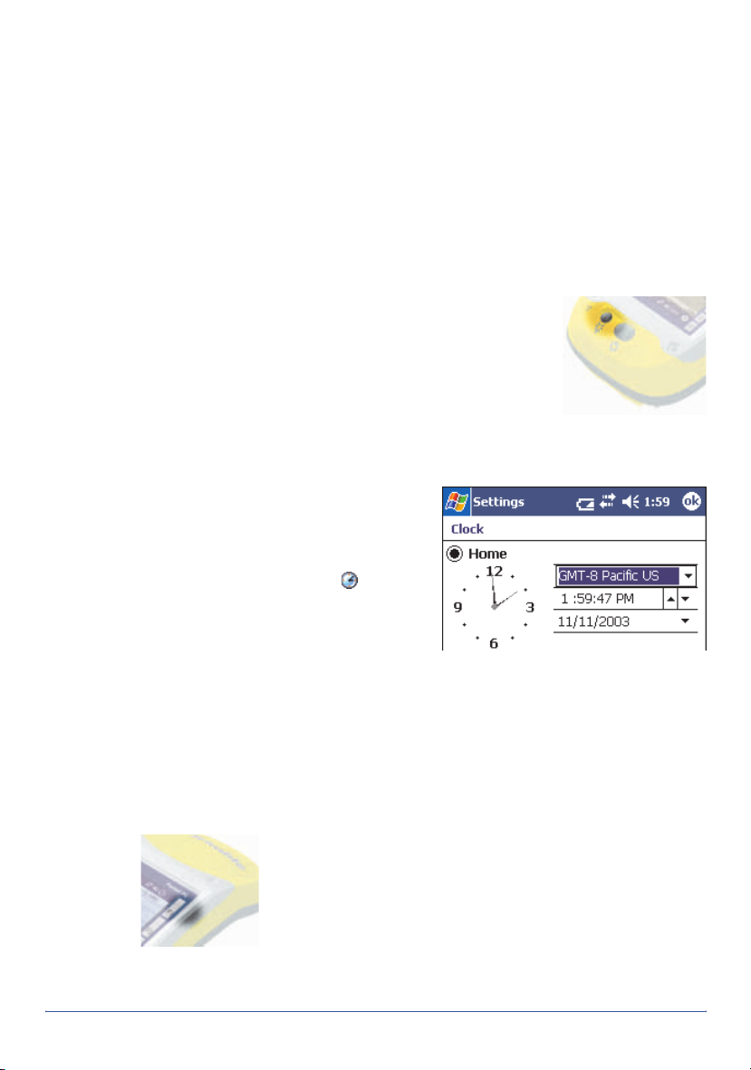
5 Set the time zone
To set the clock to your local time, the
handheld uses the GPS time reported
by the integrated GPS receiver and the
time zone that you specify. In the
screen, tap the clock icon . The
Clock Settings
the
Home
correct time zone.
screen appears. Select
option and then select the
Tod ay
6 Install and activate software
Connect the handheld to a computer and use ActiveSync to install or
activate any software you need. For more information, see Installing
software, page 13.
7Use GPS
The integrated GPS receiver is switched off until an
application opens one of the GPS COM ports. To use GPS,
take the handheld outside to a location with a clear view
of the sky. Then tap the F1 GPS touch button. The skyplot
of the default GPS software appears. Depending on the
software you have installed, this will be either GPS
Controller or TerraSync. For more information, see Using GPS, page 14.
GeoExplorer Series Getting Started Guide Getting started 7
Pocket PC basics
The GeoExplorer series handheld’s operating system is based on the
Windows Mobile 2003 software for Pocket PC.
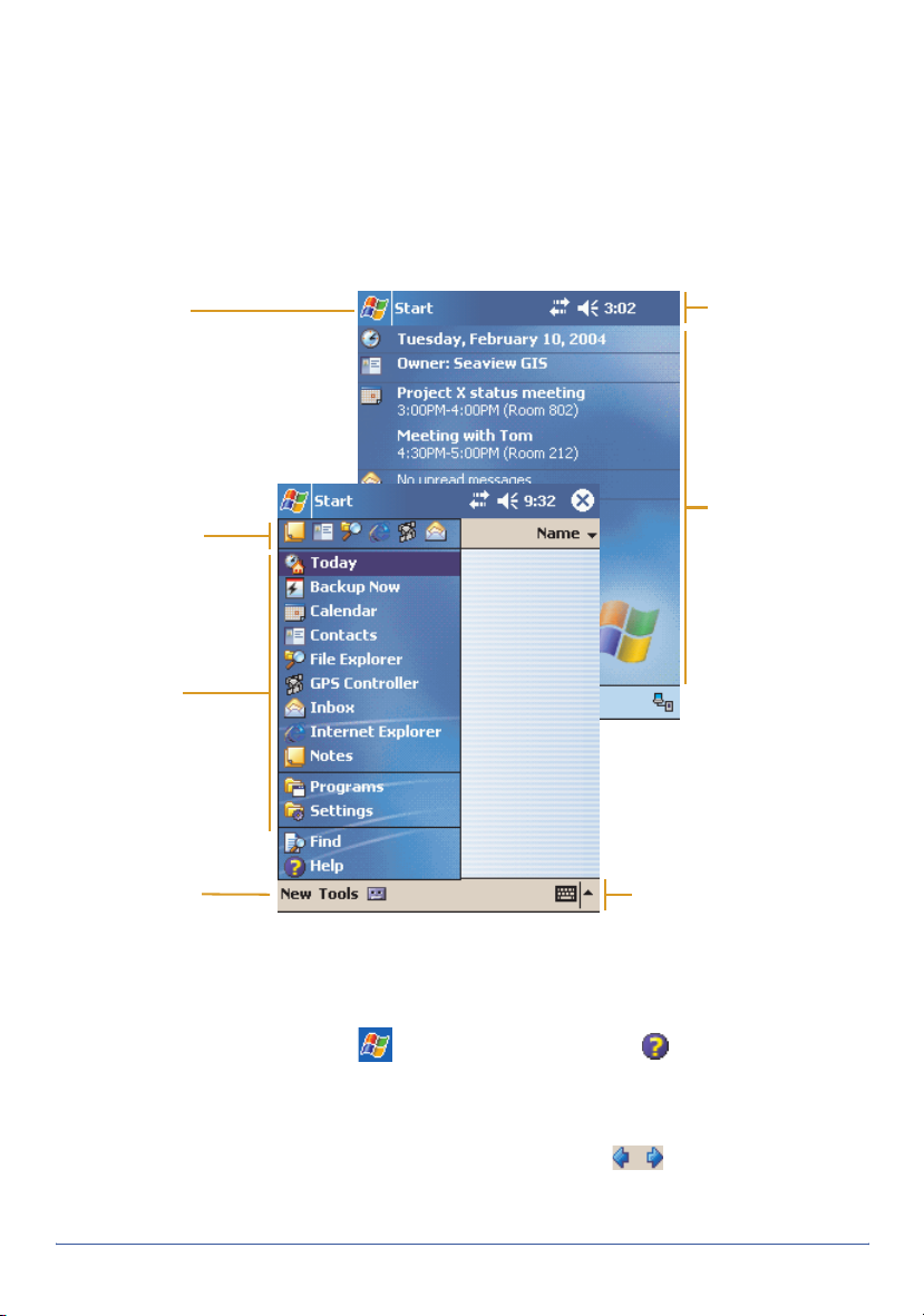
Parts of the screen
The main parts of the screen are shown below:
Start button
Tap to open the Start menu,
where you can access
programs and system
controls.
Recently used
programs list
Tap any icon to
open the program.
Start menu
Tap any ite m on
the menu to
open it.
Navigation bar
Contains status
icons for
important system
functions.
Today screen
Summarizes your
appointments,
tasks, notes, and
e-mails for the day.
Tap any item to
open it.
Command bar
Contains menu
commands and buttons.
Input Panel button
Tap to view/hide the
keyboard, or to select an
input method.
Accessing help
To access help, tap /
window. If there is an application running, context-sensitive help for the
current screen appears. Otherwise the main Help Contents page appears.
Online help on the handheld works in the same way as a Web page. Tap
hyperlinks to navigate around the help and use to retrace your steps.
Tap
View /Contents
View
/
All Installed Help
8 Pocket PC basics GeoExplorer Series Getting Started Guide
Help
or, if available, tap in the application
to return to the Contents page for the application, and
to return to the main Contents page.
Interacting with the handheld
Like most Pocket PC devices, the GeoExplorer series handheld has no
mouse or keyboard. To interact with the handheld, use the stylus to tap on
the touch screen. There are three types of action you can perform with the
stylus:
Action Definition
Tap Touch the screen once with the stylus to open items and
select options.
Tap and hold Tap and hold the stylus on an item to see a list of actions
available for that item. On the pop-up menu that appears, tap
the action you want to perform.
Drag Hold the stylus on the screen and drag across the screen to
select text and images. Drag in a list to select multiple items.
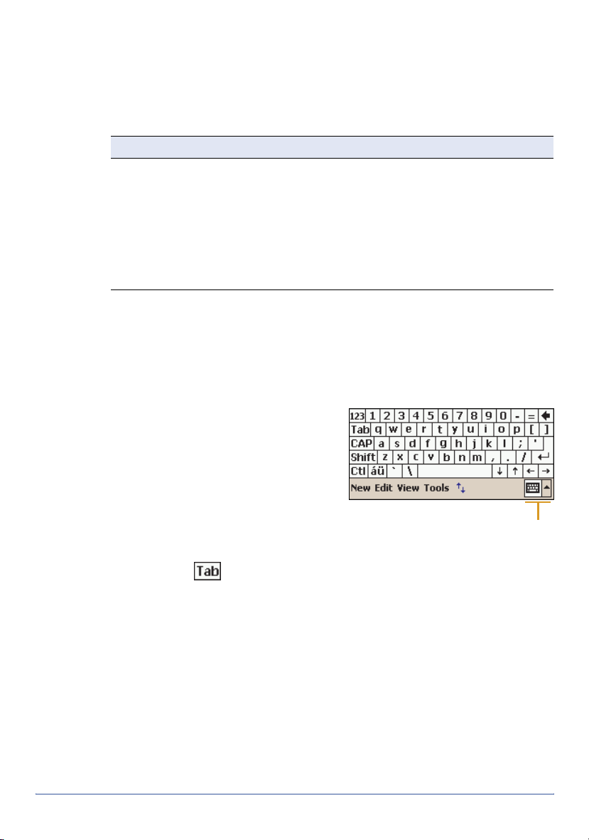
Entering text
The handheld does not have a physical keyboard. To enter text, use an onscreen keyboard. Alternatively, you can write directly onto the screen.
On-screen keyboards
To activate an on-screen keyboard,
tap the arrow on the Input Panel
button and tap
the Input Panel button changes to a
keyboard and the on-screen
keyboard appears.
To enter text, tap the appropriate
keys on the on-screen keyboard.
When you have finished entering text
in a field, tap to accept the text
you have entered and move to the next field.
To hide the keyboard, tap the keyboard icon again.
To select a different keyboard:
1. In the command bar, tap the arrow on the Input Panel button. A list of
installed keyboards pops up. The currently selected keyboard is
indicated by a check mark.
2. Tap the name of a keyboard to select it.
Keyboard
. The icon on
Input Panel button
showing keyboard
icon
GeoExplorer Series Getting Started Guide Pocket PC basics 9
Using Transcriber
The Microsoft Transcriber software converts your handwriting to text. You
can use it to enter notes in a text editor such as Notes.
To select Transcriber:
1. Tap the arrow on the Input Panel
button. A list of installed
keyboards pops up.
2. Tap
3. Tap ok. The Transcriber icon
Enabling Transcriber
By default, Transcriber is disabled.
When Transcriber is disabled, the
background of the Transcriber icon is
transparent , and Transcriber does
not convert your handwriting to text.
To enable Transcriber, tap the
Transcriber icon on the Input Panel
button. When Transcriber is enabled,
the background of the Transcriber
icon is white , and Transcriber
attempts to convert anything that you write on the touch screen to text. To
disable Transcriber, tap the Transcriber icon on the Input Panel button.
Transcriber has a number of tools and modes that allow you to customize
how it works. These tools and modes are controlled from the Transcriber
iconbar.
For more information, refer to the Transcriber Help.
Transcriber
Intro
dialog appears.
appears in the command bar.
. The
Transcriber
Input Panel button
showing Transcriber
icon
10 Pocket PC basics GeoExplorer Series Getting Started Guide

Connecting to a computer
To transfer files to or from a GeoExplorer series handheld, or to install
software on the handheld, use Microsoft ActiveSync to connect the
handheld to a computer. ActiveSync is a program that lets you exchange
information between a computer and a Pocket PC device. It also enables
you to synchronize applications such as Inbox software.
If you do not have ActiveSync installed on your computer, or you want to
use a translated version of ActiveSync, you can download it from the
Microsoft website at www.microsoft.com/windowsmobile.
To connect the handheld to a desktop computer:
1. If necessary, install ActiveSync on the computer.
2. Use the support module (see page 12), a wireless Bluetooth
connection (see page 25), or the serial clip (see page 34) to connect
the handheld to the computer. If using the serial clip, run
Programs/Connect to Desktop.
3. If ActiveSync does not connect automatically, check that connection
has been enabled in ActiveSync and on the handheld. For more
information, see Troubleshooting, page 45.
4. Follow the instructions on the
screen to connect to the
computer. You can establish
two types of connections with
ActiveSync: a partnership or
a guest relationship.
Information about a
partnership is stored
permanently on the
computer. You can use a
partnership to synchronize
files between the handheld
and a computer. If you are
going to connect to the same computer regularly, you should establish
a partnership. A guest relationship lasts only as long as the handheld
and the computer are connected.
5. If you selected a partnership, use ActiveSync to configure the
synchronization settings for your selected applications (for example,
Inbox or Calendar).
/
GeoExplorer Series Getting Started Guide Connecting to a computer 11

For more information, refer to the ActiveSync Help.
Tip — You can configure the Connection Manager in the GPS Pathfinder Office
software installed on your computer to automatically detect when you connect
a GeoExplorer series handheld to the computer, enabling you to automatically
transfer data from TerraSync, differentially correct the data, and then export it
to a GIS. For more information, refer to the GPS Pathfinder Office Help.
Support Module connection (USB)
The support module provides a fast, simple USB connection between the
GeoExplorer series handheld and a computer.
To connect using the support module:
1. Connect the USB data cable to the USB port on the support module.
2. Place the handheld in the support module. For more information, see
Getting started, page 6.
3. Connect the other end of the USB data cable to a USB port on the
computer.
Bluetooth connection
You can use the handheld’s integrated Bluetooth radio to establish a
wireless serial connection to a computer that is enabled with Bluetooth
wireless technology. For more information, see Using Bluetooth, page 25.
Serial clip connection
If you have purchased the optional serial clip, you can use it instead of the
support module to establish a serial connection to the computer. For more
information, see Using the optional serial clip, page 34.
12 Connecting to a computer GeoExplorer Series Getting Started Guide

Installing software
To install software on the handheld, first establish an ActiveSync
connection to a computer (see page 11). Then follow the installation
instructions that are provided with the software. If no instructions are
provided, run the program file (.exe file) on a computer:
• If the file is an installer, the installation wizard will begin. Follow the
instructions on the screen. Once the software is installed on the
computer, the installer will automatically transfer it to the handheld.
• If the file is not an installer, an error message appears, stating that the
program is valid but designed for a different type of computer. Use
ActiveSync to copy the file to the Program Files folder on the handheld.
Note — The GeoExplorer series handheld supports software designed to run
on Windows Mobile 2003 software for Pocket PCs. You may also be able to
install and run some software designed for other operating systems.
Installing TerraSync
You can install version 2.40 or later of the TerraSync software on a
GeoExplorer series handheld.
To in stall Te r raSyn c, eithe r inser t th e
Guide CD
or run the downloaded setup file. To obtain a serial number for installation,
you must register your copy of TerraSync online. Detailed installation
instructions are provided in the
in the CD-ROM drive of a computer and use the menus provided,
TerraSync Software and Operation
TerraSync Release Notes
.
Installing ArcPad
You can install version 6.0.2 or later of the ESRI ArcPad software on a
GeoExplorer series handheld. Detailed installation instructions for ESRI
ArcPad are provided in the ArcPad documentation. You can also download
installation instructions from the ESRI website at www.esri.com/arcpad.
Installing GPScorrect
You can install version 1.01 or later of the GPScorrect software on a
GeoExplorer series handheld. Before you install the GPScorrect software,
install version 6.0.2 or later of ArcPad.
To install GPScorrect, either insert the
of a computer and use the menus provided, or run the downloaded setup
file. Detailed installation instructions are provided in the
Release Notes
GeoExplorer Series Getting Started Guide Installing software 13
.
GPScorrect CD
in the CD-ROM drive
GPScorrect

Using GPS
To use GPS in an application, you need to:
• configure the application to connect to GPS (see page 15)
• get a clear view of the sky (see page 16)
• configure GPS quality control settings to suit your requirements and
the current GPS conditions (see page 16)
You may also want to:
• use mission planning to identify the best times of the day for working
with GPS (see page 17)
• use real-time differential corrections for better accuracy (see page 19)
• use GPS data collection and navigation features (refer to the
documentation for the GPS application).
GPS COM ports
The integrated GPS receiver has three COM ports for communicating with
software on the handheld and with external devices. Using GPS is as
simple as opening the appropriate GPS COM port. Each port is used for a
particular type of communication:
Port Function Description
COM2 NMEA Outputs NMEA-0183 messages. NMEA is a standard
COM3 TSIP Outputs and receives TSIP messages. TSIP (Trimble
COM4 Real-time Receives RTCM real-time correction messages. If you
GPS communication protocol used by most GPS
applications.
The handheld outputs the following NMEA messages:
GGA, GLL, GSA, GSV, RMC, VTG, ZDA. All messages are
output at a 1-second interval.
Standard Interface Protocol) is used by Trimble GPS
applications, and is also supported by some other GPS
applications.
are using an external correction source connected to
COM1 or a Bluetooth port, the corrections must be
redirected to COM4. For more information, see Using
real-time corrections from other sources, page 18.
Note — COM1 is a standard serial port that connects to external devices. For
more information, see Using the optional serial clip, page 34.
14 Using GPS GeoExplorer Series Getting Started Guide

Configuring a GPS application
The first time you use GPS software on the handheld, you may need to
specify which GPS COM port to connect to. Specify COM2 if the software
uses NMEA, or COM3 if the software uses TSIP. If you are not sure which
protocol to use, check the documentation for the software.
If you are using … do this …
GPS Controller Tap the F1 GPS touch button to run GPS Controller.
The software automatically activates the integrated
GPS receiver on COM3.
TerraSync Tap the F1 GPS touch button to run TerraSync. The
software automatically activates the integrated GPS
receiver on COM3.
ArcPad with the
GPScorrect
extension
ArcPad 1. In ArcPad, tap the Tools button .
Tip — ArcPad can also connect using the TSIP protocol. However, if you use
the NMEA protocol, you can run GPS Controller at the same time for
advanced GPS and real-time configuration and status information.
NMEA application Configure the software to connect to GPS on COM2,
TSIP application Configure the software to connect to GPS on COM3,
1. Tap the GPS button . The software activates
the integrated GPS receiver on COM3.
2. If you want to configure GPS and real-time, or view
status information, run GPScorrect. In the Trimble
toolbar, tap the GPScorrect button .
2. In the
3. Tap the
COM2.
4. Tap OK.
5. Tap the GPS button . The software activates
the integrated GPS receiver.
then use the Connect or Activate GPS command.
then use the Connect or Activate GPS command.
Protocol
field select NMEA 0183.
GPS
tab and from the
Port
field select
Tip — Only software that is running on the handheld can connect directly to a
GPS COM port. To supply GPS data to an external device, use GPS Connector
(see page 19) to redirect the output from the appropriate GPS COM port to a
serial port or to a Bluetooth port. Then configure the external device to
connect to that serial or Bluetooth port.
GeoExplorer Series Getting Started Guide Using GPS 15

Getting a clear view of the sky
To receive signals from GPS satellites, you must be in a location with a
clear view of the sky. GPS does not work indoors. Hold the handheld with
the screen toward you. The internal antenna is located above the screen
under the Trimble logo. You do not have to hold the handheld perfectly
level, but keep the antenna facing upward, not downward or sideways.
Anything that blocks light also blocks signals. Satellite signals can be
blocked by people, buildings, heavy tree cover, large vehicles, or powerful
transmitters. GPS signals can go through leaves, plastic, and glass, but
these all weaken the signal.
GPS quality control
By default, the handheld is configured to receive satellite signals in most
conditions. To check the current GPS status, or to configure the integrated
GPS receiver, tap the F1 GPS touch button. The Skyplot section of the GPS
Controller software appears.
The GPS Controller software is pre-installed on all GeoExplorer series
handhelds to give you access to advanced GPS settings and status details.
Use the graphical Skyplot section or
the Satellite Info section to view
detailed GPS information, and to
adjust the quality and yield of the GPS
positions you are receiving. Use the
GPS slider to select predefined
settings, or configure customized
settings.
GPS Controller also includes a Plan
section for mission planning (see
page 17) and a Real-time section for
configuring and monitoring real-time
correction sources (see page 19). For
more information on any GPS
Controller section or function, refer to
the GPS Controller Help.
Note — GPS Controller duplicates the status and setup features of TerraSync
and the GPScorrect extension for ArcPad. If one of these applications is
installed, it runs instead of GPS Controller when you tap the F1 GPS touch
button. For more information on TerraSync or GPScorrect, refer to the
documentation for that application.
16 Using GPS GeoExplorer Series Getting Started Guide

Planning a data collection session
To maximize productivity, plan GPS
data collection around the times of
the day when satellite geometry is
best. The GPS Controller software
includes a Plan section with an
animated skyplot and DOP (satellite
geometry) graph for your position for
the next 12 hours.
In the Plan section, you can check the
planning skyplot as you play a
session, then use the timeline to
zoom in on times when geometry is
poor. As you adjust GPS settings, the
Plan section is updated, so you can
see the effect of different quality
control settings.
Note — If TerraSync or the GPScorrect extension for ArcPad is installed, use
the planning feature in that application instead of in GPS Controller.
Using WAAS/EGNOS corrections
The GeoExplorer series handheld has an integrated receiver that uses
WAAS (Wide Area Augmentation System) or EGNOS (European
Geostationary Navigation Overlay System) correction messages to improve
GPS accuracy. The receiver tracks WAAS satellites between 30° West and
180° West, and tracks EGNOS satellites between 30° West and 90° East.
GeoExplorer Series Getting Started Guide Using GPS 17

To use WAAS/EGNOS corrections:
1. In GPS Controller, open the
Real-time section and tap the
Setup button .
2. In the
3. Tap OK.
Note — If TerraSync or the GPScorrect
extension for ArcPad is installed,
configure real-time settings in that
application instead of in GPS Controller.
Choice 1
Integrated WAAS. In the
2
field, specify whether to use
uncorrected positions, or to
stop using GPS positions, if
corrections are not available.
field, select
Choice
Using real-time corrections from other sources
You can use corrections from an external correction source, such as a
Beacon-on-a-Belt (BoB) receiver, a DGPS radio, or a mobile phone. The
external correction source can be connected to a Bluetooth port or to the
optional serial clip (COM1). Use GPS Controller to set up and monitor the
real-time input source that you want to use.
Note — If TerraSync or the GPScorrect extension for ArcPad is installed,
configure real-time settings in that application instead of in GPS Controller.
The integrated GPS receiver only communicates through its GPS COM
ports (COM2, COM3, and COM4). Input from an external correction source
connected to COM1 or a Bluetooth port must be redirected to the real-time
GPS COM port (COM4). Trimble applications, such as GPS Controller,
handle the redirection automatically. If you are using any other application
to set up and monitor real-time sources, use GPS Connector to redirect the
input to COM4. For more information, see GPS Connector, page 19.
18 Using GPS GeoExplorer Series Getting Started Guide

GPS Connector
The GPS Connector software is
pre-installed on all GeoExplorer series
handhelds. To open GPS Connector, tap
/
Settings/Connections/GPS
Connector
GPS Connector lets you connect the GPS
COM ports to COM1 or Bluetooth ports
and configure port settings such as the
baud rate. GPS Connector has a
graphical display that shows all active
connections, and a text display that
shows connection messages.
Use GPS Connector to output NMEA or
TSIP messages from the integrated
GPS receiver to another device, such
as an external data collector.
Note — If you are using a Bluetooth port,
enable and configure the Bluetooth
Serial Port service before you connect to
the port.
The connections that you create in
GPS Connector are only active while
the software is running. Connections
created by GPS Connector are labeled
GPS Connector in the status screen
and end when you exit the software.
For more information, refer to the GPS
Connector Help.
.
GeoExplorer Series Getting Started Guide Using GPS 19

Power
When fully charged, the internal battery of the handheld provides enough
power for a full working day using GPS. To extend the time between
charges, use the optional vehicle power adaptor or the portable power kit.
Using the support module with the AC power adaptor recharges the
internal battery. In the office, leave the GeoExplorer series handheld in the
support module to conserve the battery.
Suspend mode
When you press the Power button to turn off the handheld, the handheld
goes into Suspend mode. This is a low-power mode that maintains the
main memory contents but does not allow you to operate any of the
handheld’s functions. The handheld appears to be turned off. The
integrated GPS receiver is turned off and any application using GPS is
disconnected.
When the handheld is in Suspend mode, press the Power button again to
turn on the handheld. It is instantly ready for operation. There may be a
delay of up to 30 seconds while the integrated GPS receiver automatically
reactivates.
You can configure the handheld to
automatically enter Suspend mode
when it has been idle for a specified
time. By default, the handheld is set to
enter Suspend mode if the handheld
is not used for three minutes.
To change the time to enter Suspend
mode:
1. Tap /
Power
2. Tap the
3. From the
select the
used for
idle time from the drop-down list.
4. Tap ok.
Settings/System
.
Advanced
On battery power
tab.
group,
Turn off dev i c e i f not
check box and select the
/
20 Power GeoExplorer Series Getting Started Guide

Charging the battery
Use the support module to charge the handheld’s internal battery. The
battery takes approximately five hours to recharge fully.
Tip — If you are not going to use the handheld for some time, either keep the
handheld connected to mains power to continually charge it, or fully charge
the handheld and switch it off. For more information, see Storage, page 50.
To charge the internal battery using the support module:
1. Use the AC power adaptor to connect the
support module to mains power.
2. Place the handheld in the support module.
3. Leave for up to five hours to recharge.
You can also use the optional serial clip to
recharge the internal battery. For more
information, see Using the optional serial clip, page 34.
Note — The Power Settings screen always shows 100% power for the backup
battery. The handheld does not have a backup battery installed because the
main memory is automatically backed up if the main battery runs low. For
more information, see Backing up data, page 22.
Conserving power
Although the handheld battery can operate for a full day without
recharging, you should try to conserve battery power as much as possible.
Follow these tips to reduce power consumption:
• Disconnect from the integrated GPS receiver when the receiver is not
in use. When you disconnect from GPS, the integrated GPS receiver
switches off and stops drawing power. Whenever GPS data is not
required, use the application’s Disconnect or Deactivate GPS option,
or exit the application.
Tip — Do not disconnect from GPS if you will be reconnecting within about
five minutes. A GPS application can take up to 30 seconds to reactivate
the integrated GPS receiver, so disconnecting to save power can cost time.
• Turn off the integrated Bluetooth radio whenever you are not using it.
For more information, see Using Bluetooth, page 25.
• Do not use the backlight, unless required. To turn off the backlight,
press the Display button. You can also set the backlight to
automatically turn off if the handheld has been idle for a specified
time. For more information, see Backlight, page 38.
• Set the handheld to automatically enter Suspend mode when idle. For
more information, see Suspend mode, page 20.
GeoExplorer Series Getting Started Guide Power 21

Memory
The handheld has two types of memory.
The main memory, which is similar to the RAM in a computer, is used
mainly for running programs, but it also stores essential files for the
Windows Mobile software. As with other Pocket PCs, you can adjust how
much of the main memory is allocated to running programs and how much
is allocated to storing data. For more information, see Memory
management, page 24.
The Disk, which is similar to the hard
disk in a computer, is used for storing
programs and data. The Disk is a
non-volatile storage location, so files
stored on the Disk are much safer
than files stored in the main memory.
To check the memory capacity on the
handheld, tap /
System/System Information
RAM
show the total memory in each
location, as well as the amount of
memory in each location that is
reserved by the operating system.
Some applications require program
and data files to be stored in main
memory (RAM). To allow such software to operate correctly, some folders
on the Disk are duplicated in main memory. You can store files and install
software in either location. However, unless using the Disk causes
problems when you run applications, Trimble recommends that you store
programs and data on the Disk.
field and the
Settings
Flash Disk
/
. The
field
Backing up data
To protect your data, back up the main memory and the Disk regularly.
The GeoExplorer series handheld features Pocket Backup, which enables
you to back up and restore the main memory, or selected files, folders,
registry settings and databases. With Pocket Backup you can schedule
regular back ups, and it will automatically back up the main memory when
the battery runs low.
To change Pocket Backup settings, tap /
and tap
22 Memory GeoExplorer Series Getting Started Guide
Options
.
Programs
/
Pocket Backup

Backing up the memory
If the handheld loses power, or you perform a hard reset, the main
memory is cleared. When the handheld restarts, you can restore the main
memory from the last backup.
Note — Any unsaved data and any changes in the main memory since the
last backup are lost
To back up the main memory, do one of the following:
• Tap /
• Tap /
To restore the main memory:
1. Either:
• Tap /
• Hard reset the handheld.
2. When the
handheld will restore the main memory and automatically perform a
soft reset. For more information, see Resetting, page 24.
.
Backup Now
Programs
Programs
.
/
Pocket Backup
/
Restore Now.
Restore from Backup
.
dialog box appears, tap Yes. The
Backing up the Disk
The Disk is non-volatile memory, so documents and program files that are
stored on the Disk are not affected by power loss or resetting. However,
you can still lose data if you accidentally delete or overwrite it.
Warning — When you delete files from the Disk, they are deleted permanently.
The GeoExplorer series handheld does not have a Recycle Bin.
To protect your data, Trimble recommends that you use ActiveSync to
regularly create a backup copy of the Disk on a computer.
Note — The Backup/Restore command in ActiveSync’s Tools menu backs up
only the main memory (RAM). It does not back up the Disk.
To back up files from the Disk:
1. Connect the handheld to the computer using ActiveSync.
2. In ActiveSync, click Explore. Windows Explorer opens, showing the
contents of the handheld.
3. Browse to the location of the files that you want to back up.
4. Select the files that you want to back up, and then copy them to the
computer.
GeoExplorer Series Getting Started Guide Memory 23

Resetting
To restore files to the Disk from a backup on a computer:
1. Connect the handheld to the computer using ActiveSync.
2. Copy files from the backup copy on the computer to the handheld,
overwriting the existing files.
If the handheld stops responding to the stylus, or the screen goes blank,
you may need to reset it.
To reset the GeoExplorer series handheld:
1. If the screen is still responding to stylus taps, back up the main
memory. For more information, see Backing up data, page 22.
2. Do one of the following:
• Soft reset: If an application has stopped responding, hold down
the Power button until the screen goes blank (about 5 seconds).
The handheld restarts automatically.
Note — Avoid pressing the Display button during a soft reset, as the
handheld will not restart automatically.
• Hard reset: If a soft reset does not work, hold down the Power
button for 15 seconds to turn the handheld off, then press the
Power button to turn it on again.
The main memory is cleared and can be restored from the backup
on the Disk. You will lose any unsaved data (for example, any
unsaved changes to documents), and any data in the main
memory that has changed since the last main memory backup.
Note — Files stored on the Disk are not affected by a reset.
Tip — To restore the handheld to the factory default settings, tap No when
the
Restore from Backup
dialog box appears after a hard reset.
Memory management
To protect your data, Trimble recommends that you install all programs to
the Disk, and store all documents on the Disk. This also improves
performance, because more memory can be allocated to running programs.
24 Memory GeoExplorer Series Getting Started Guide

Using Bluetooth
The GeoExplorer series handheld has an integrated Bluetooth radio that
you can use to establish a wireless connection to other Bluetooth devices
that are within range. Using a Bluetooth connection, you can communicate
with devices such as mobile phones, desktop computers, handhelds, and
digital cameras. You can also communicate with peripheral devices that
use Bluetooth adaptors instead of serial or USB connections.
To communicate using a Bluetooth connection, a client device scans the
Bluetooth radio frequency to “discover” other Bluetooth devices. Once it
has discovered a host, the client selects the service that it will use. A
service defines what type of information can be transferred to or from the
host, and how.
The handheld can be used as a client or as a host, and can act as both at
the same time.
host
client
host
This section provides information on:
• accessing Bluetooth settings (see page 26)
• turning on the integrated Bluetooth radio (see page 26)
• making the handheld Discoverable (see page 27)
• bonding with other Bluetooth devices (see page 27)
• connecting to a Bluetooth service as a client (see page 28)
• providing Bluetooth services as a host (see page 32)
GeoExplorer Series Getting Started Guide Using Bluetooth 25
host

Setting up Bluetooth
Use the Bluetooth settings window to turn on the integrated Bluetooth
radio, scan for and bond with other Bluetooth devices, and configure host
services on the GeoExplorer series handheld.
Note — The handheld is shipped with the integrated Bluetooth radio
deactivated. You may only activate the Bluetooth radio if GeoExplorer series
handhelds have been granted Bluetooth type approval in the country where
you will use the handheld. For more information, visit the Trimble website at
www.trimble.com/geo_bluetooth.html.
To set up Bluetooth, do one of the following:
• Tap the F4 touch b utton .
• Tap /
Settings/Connections/Bluetooth
Turning on the Bluetooth radio
To use the GeoExplorer series
handheld as a Bluetooth host or
client, you must enable the Bluetooth
radio.
To turn on the Bluetooth radio:
1. Tap
2. In the
Note — If the integrated Bluetooth radio
is not activated, the message No
Bluetooth hardware appears.
/
Settings
Connections/Bluetooth
Mode
option. This enables the
integrated Bluetooth radio..
/
tab, select the
.
.
On
Tip — To conserve power, turn off the
Bluetooth radio when it is not in use.
Enabling Flight mode
When Flight mode is enabled, the handheld cannot send or receive
Bluetooth signals.
To enable Flight mode, do one of the following:
• Tap /
signals off (Flight mode)
• Tap in the navigation bar, and tap
26 Using Bluetooth GeoExplorer Series Getting Started Guide
Settings/System/Power /Wireless
.
Turn on f l i g h t mode
tab. Select
Wireless
.

Making the handheld Discoverable
If you want to set up a bond with another Bluetooth device, or if you want
to use the handheld as a host device, you need to make the handheld
Discoverable. A discoverable device can be detected by other devices
when they scan.
To turn on the Bluetooth radio:
1. Tap
2. In the
/
Settings/ Connections/Bluetooth
Mode
tab, tap the
Discoverable
Bonding with a Bluetooth device
Creating a bond between the handheld and another Bluetooth device
helps to exchange information securely between the devices. Once a bond
is created, the handheld and the other Bluetooth device only need to have
their Bluetooth radios turned on to exchange information; they do not need
to be in discoverable mode.
To bond with a Bluetooth device:
1. Make sure that the handheld and
the Bluetooth device you want to
bond with are within 5 meters of
each other, and that Bluetooth is
in Discoverable mode on both
devices.
2. Tap
3. In the Bonded Devices list, tap
4. Tap the name of the device you
5. In the
6. Enter the same PIN on the other device.
7. In the
8. Tap Finish.
Tip — You only need to create a bond once between two devices.
/
Settings
Connections/Bluetooth
the
Bonded Devices
New. The handheld searches for
other Bluetooth devices and
displays them in the list.
want to bond with, and tap Next.
PIN
field, enter a PIN of between 1 and 16 characters and tap
Next.
Name
/
, and tap
tab.
field, change the name of the device if required.
.
option.
GeoExplorer Series Getting Started Guide Using Bluetooth 27

Connecting to a Bluetooth service as a client
You can use the GeoExplorer series handheld as a Bluetooth client. A
Bluetooth client uses services offered by Bluetooth host devices that are
within range.
For example, you can connect the handheld to a mobile phone that has an
internal modem, so that you can access the Internet. The mobile phone is
the host (because it is providing the Dial-up Networking (DUN) service) and
the handheld is a client using that service.
The GeoExplorer series handheld can connect to the following services:
Service Description
ActiveSync Enables an ActiveSync connection to a computer. To use
an ActiveSync service, enable the Bluetooth port on the
computer and then configure ActiveSync to use this port.
Bond with an ActiveSync service (see page 27), and set up
a client serial port for the device, making sure you select
Default Bluetooth ActiveSync
the
Programs/ ActiveSync
/
Bluetooth
Dial-Up Network Connects the handheld to a mobile phone or modem for
dial-up network or Internet access. Bond with a Bluetooth
service (see page 27), tap /
.
Connections/Connections
connection. From the list of modems, select the Bluetooth
mobile phone or modem that you have connected to.
File Transfer Allows the handheld to view, copy, add, and delete folders
and files on the host. Bond with a File Transfer service
(see page 27), and tap /
Tra nsfer
select the host device. The host’s transfer folder and its
contents appear in a Windows Explorer-style window.
Beam Objects Allows the handheld and host to exchange data objects
such as virtual calendars.
Lan Access Point Allows the handheld to browse the Internet and network
computers using a Local Area Network (LAN). Bond with a
LAN (see page 27), then tap the
up the connection (see page 29).
Serial Port Emulates an RS-232 serial (COM) port on the handheld.
. From the
File
and tap
, and add a new dial-up
menu, select
check box. Then tap
Tool s
/
Connect via
Settings
/
Programs/ Bluetooth File
Connect
LAN Access
, and then
tab and set
28 Using Bluetooth GeoExplorer Series Getting Started Guide

Setting up a LAN Access Point
By bonding with a Local Area Network (LAN) access point, you can browse
the Internet or network computers remotely using the handheld.
To set up a LAN Access Point connection:
1. Create a bond with the LAN access point you want to use (see
page 27).
2. In the
3. In the LAN Access Points list, tap
4. In the
5. Enter a user name and password
6. Tap Finish.
7. To connect to the LAN access
Tip — Before you bond with another Bluetooth device, make sure you
disconnect from the LAN access point so that the handheld is able to scan for
other Bluetooth devices.
Bluetooth
New. The
Point
dialog appears.
LAP
access point you want to use from
the drop-down list.
for the field using the connection
details supplied by your ISP or
network administrator.
point, tap and hold the name of
the LAP in the LAN Access Points
list, and tap Connect. The next
to the LAN access point in the list
indicates it is connected.
window, tap the
Set up the LAN Access
field, select the LAN
LAN Access
tab.
Setting up a Client Serial Port
A Serial Port service creates a virtual serial port on the GeoExplorer series
handheld. You can use this port to connect to another Bluetooth device,
just as you would use a physical COM port and a cable to connect to a
physical serial port. Like a physical port, the virtual serial port sends and
receives data using the RS-232 serial communication protocol.
Unlike other Bluetooth connections, you don’t need to bond with the other
device before you set up the client serial port connection. This means you
can set up serial port connections with devices that otherwise you would
not be able to bond with, such as the Trimble 5800 receiver, which does
not have a keypad for entering a PIN.
For more information about serial port services, see page (see page 32).
GeoExplorer Series Getting Started Guide Using Bluetooth 29

To set up a client serial port connection:
1. Make sure that the host
Bluetooth device is Discoverable.
2. Make the handheld Discoverable
(see page 27), and tap the
Ports
tab.
3. Add a new client serial port, or
change the settings for an
existing one.
• To change the settings for an
existing client serial port, tap
and hold the name of the
serial port in the
Ports
list.
• To add a new client serial
port, tap
Serial Ports
immediately shows any
bonded devices that have a
serial port profile exposed.
The Searching icon appears,
and the handheld scans for
any other Bluetooth devices
that are within range and that
expose the serial port profile.
Tap the name of the serial
port you want to set up, and
tap Next.
New
in the
list. The list
Serial
Client Serial
Client
30 Using Bluetooth GeoExplorer Series Getting Started Guide

4. The
5. From the
6. Normally, the host device handles
7. To select this client as the default device for ActiveSync, select the
8. Tap Finish. The client serial port you have just set up is listed under
Applications on the handheld can now use the client serial port you have
set up. If the host requires authentication, you must enter a PIN to
connect.
Setup the Bluetooth device
dialog appears. The name of the
host device is in the
Edit the
Name
Port
available COM or BSP port on the
handheld. The next available port
is selected as the default.
Tip — If the application that will use
this service cannot recognize BSP
ports, select a COM port.
authentication and encryption. If
you require these options, but the
host cannot be configured, select
the
Authentication
check boxes.
Name
field if required.
list, select an
and
Encryption
Default Bluetooth ActiveSync
New... in the Client Serial Ports list, with the assigned port indicated.
The ActiveSync icon appears to the left of the default Bluetooth
ActiveSync device.
field.
check box.
GeoExplorer Series Getting Started Guide Using Bluetooth 31

Providing Bluetooth services as a host
You can use the predefined Bluetooth host services on the
GeoExplorer series handheld, or create additional Serial Port services.
To provide a host service, turn on the Bluetooth radio (see page 26) and
make the device Discoverable (see page 27). If the service is a Serial Port
service, you may need to add or configure the service (see page 33). The
other host services do not require any configuration.
The GeoExplorer series handheld provides the following host services:
Service Description
Basic Imaging Allows the client to preview, browse, and copy JPEG image
files, and to send JPEG files to the handheld.
File Transfer Allows a client to browse, copy, paste, and delete files and
folders on the handheld.
Beam Object Allows the handheld and the client to exchange data
objects, such as virtual business cards, or virtual
calendars.
Serial Port Emulates an RS-232 serial (COM) port on the handheld.
For more information, see Serial Port services, page 32.
You can only configure Serial Port services. Other services use
pre-assigned ports, use the \Disk\My Documents\File Transfer folder for
file transfers, and have authentication and encryption enabled.
Serial Port services
A Serial Port service creates a virtual serial port on the GeoExplorer series
handheld. You can use this port to connect to another Bluetooth device,
just as you would use a physical COM port and a cable to connect to a
physical serial port. Like a physical port, the virtual serial port sends and
receives data using the RS-232 serial communication protocol.
Tip — Trimble applications, such as GPS Controller and TerraSync, can
connect to BSP ports as well as to COM ports. However, some other
applications do not recognize BSP ports. If a client device is unable to connect
to a Serial Port service that uses a BSP port, configure the service to use a
COM port instead.
A Serial Port service is already set up on the handheld. By default, this
service uses COM6. You can change the COM port and the service name.
You can also add new Serial Port services that use other COM ports or BSP
ports.
32 Using Bluetooth GeoExplorer Series Getting Started Guide

To add or configure a Host Serial Port service:
1. Make sure that the client Bluetooth device is Discoverable.
2. Make the handheld Discoverable (see page 27), and tap the
Ports
tab.
3. Add a new host serial port, or change the settings for an existing one.
• To change the settings for an existing host serial port, tap and hold
the name of the serial port in the
• To add a new host serial port, tap
4. The
5. In the
6. From the
7. T h e
8. The
9. Tap Finish to return to the
Applications on the handheld can now use the COM or BSP port that you
selected for this service. For example, to provide NMEA messages to a
Bluetooth client, use GPS Connector to output NMEA from the integrated
GPS receiver to the selected COM or BSP port.
Setup the Bluetooth Device
dialog appears.
Name
field, enter a unique
name, or for an existing host serial
port, edit the name if required.
Port
list, select an
available COM or BSP port on the
handheld. The next available port
is selected as the default.
Authentication
selected by default. When the
host connects to this service, the
Enter PIN
PIN in this dialog, and then enter
the same PIN on the client.
Note — Authentication helps to ensure that your data remains secure.
However, if you enable authentication, only client devices that support PIN
entry will be able to connect to the service.
dialog appears. Enter a
Encryption
transferred using this service will be encrypted.
check box is
check box is selected by default, so that data
Serial Ports
listed in the Host Serial Ports list, with the assigned port indicated.
Host Serial Ports
New
in the
Host Serial Ports
tab. The new host serial port is
Serial
list.
list.
GeoExplorer Series Getting Started Guide Using Bluetooth 33

Using the optional serial clip
The optional serial clip attaches to the communication swipes on the back
of the handheld. When the serial clip is attached, it adds a serial port
(COM1) to the GeoExplorer series handheld.
You can use the serial clip to:
• supply external power from a camcorder battery or a vehicle’s battery
(see page 36)
• recharge the internal battery from an external power source (see
page 36)
• connect to a computer to transfer data, back up the Disk, or install
software (see page 35)
• receive differential corrections from an external real-time correction
source, such as a Beacon-on-a-Belt receiver or DGPS radio
• receive GPS data from a Trimble GPS Pathfinder receiver
• connect to an external modem or mobile phone for wireless Internet
access
• connect to other external devices, such as a laser rangefinder
Attaching the serial clip
The serial clip must be screwed onto the handheld. When the serial clip is
attached, you cannot place the handheld in the support module.
To attach the serial clip to the GeoExplorer series handheld:
1. Line up the communication swipes on the handheld with the pins on
the serial clip.
2. Lower the handheld onto the serial clip.
3. Use the screws supplied with the serial clip to secure it to the
handheld.
screw
34 Using the optional serial clip GeoExplorer Series Getting Started Guide

Connecting to external devices
You can use the serial clip instead of the support module to connect to a
computer. It also provides a serial port to connect to other devices.
To connect to an external device:
1. Attach the serial clip to the handheld.
2. Plug the null modem cable into the serial (COM) port on the serial clip.
3. Connect the other end of the cable to the serial port on the external
device.
4. If you are connecting to a computer, tap
Desktop
connection icon appears in the navigation bar.
For more information
about transferring data
between a
GeoExplorer series
handheld and a desktop
computer, see Connecting
to a computer, page 11.
. When the handheld is connected to the computer, the
/
Programs/ Connect to
To connect to a device that does not
have a serial port, such as an external
modem or mobile phone, use a cable
that has a DE9 connector on one end,
and the appropriate connector for the
other device on the other end. A
suitable cable may be supplied with the
external device.
For more information about using an
external modem or mobile phone to
access the Internet, see Internet and
network connection, page 41.
GeoExplorer Series Getting Started Guide Using the optional serial clip 35

Using external power
The serial clip lets you connect the GeoExplorer series handheld to an
external power source. Depending on the optional accessories that you
have purchased, you can use mains power, a camcorder battery, or a
vehicle’s battery to supply power to the handheld.
To connect to an external power source:
1. Attach the serial clip to the handheld.
2. Plug the appropriate cable into the power port on the serial clip.
3. Connect the other end of the cable to the external power source.
To use power from … connect this cable … to …
AC power source
(mains power)
camcorder battery camcorder power adaptor cable
vehicle battery optional vehicle power adaptor vehicle’s cigarette
AC power adaptor supplied with
the handheld
from optional portable power kit
AC power outlet
camcorder battery
from optional
portable power kit
lighter socket
Recharging from an external power source
By default, the GeoExplorer series handheld recharges its internal battery
from any external power source that is connected. Recharging the battery
draws more power from the external source than is used to power the
handheld.
36 Using the optional serial clip GeoExplorer Series Getting Started Guide

Customizing the Handheld
Use the controls in the
following are examples of the controls that are available.
Settings
screen to customize the handheld. The
Power
Use the
all wireless signals from the handheld, and the
idle time before Suspend mode is activated. For more information, see
Using the optional serial clip, page 34, Enabling Flight mode, page 26
and Conserving power, page 21.
Battery
tab to check the battery level, the
Advanced
Wireless
tab to set the
tab to turn off
Today
Use the Today control to change the
display theme that controls the
appearance of the
to customize the items that appear on
the
Tod ay
screen.
Appearance
You can use a theme to customize the
background picture on the
screen, and the color of the navigation
bar, comma nd bar, menus, and
messages.
To change the display theme:
1. Tap /
Today
.
2. Tap the
3. Do one of the following:
• To use a predefined theme, select it from the list.
• To select the picture that you want to display in the
background, select the
box. Then tap Browse to search for a file on the handheld.
4. Tap ok to confirm the changes and close the dialog.
Today
screen, and
Today
Settings/Personal /
Appearance
tab.
Today
Use this picture as the background
screen
check
GeoExplorer Series Getting Started Guide Customizing the Handheld 37

Items
You can choose the items that appear on the
that they appear in.
To change the items that appear on
the Today screen:
1. Tap /
2. Tap the
3. Select or clear the check boxes to
display or hide the
items.
4. Use the Move Up and Move Down
buttons to change where the
selected item appears on the
Today
5. Tap ok to confirm the changes
and close the dialog.
Settings/Today
Items
tab.
screen.
Today
.
screen
Tod ay
screen, and the order
Backlight
Use the Backlight control to configure power-saving settings for the
backlight. The backlight makes the screen easier to read in low light, but
uses extra power.
To change the backlight settings:
1. Tap /
Backlight
2. To automatically turn off the
backlight when the handheld is
idle and is using battery power,
select the
box and select a time from the
drop-down list.
3. To automatically turn off the
backlight when the handheld is
idle and is using external power,
select the
box and select a time from the
drop-down list.
4. Tap ok to confirm the changes
and close the dialog.
Settings/System
.
Battery Power
check
External Power
/
check
38 Customizing the Handheld GeoExplorer Series Getting Started Guide

Screen
Use the
touch screen or to change the
appearance of text on the screen.
To change the screen settings:
1. Tap /
2. To start the alignment sequence
3. To use ClearType font smoothing,
4. Tap ok to confirm the changes and
Screen
control to align the
Settings/System
Screen
for the touch screen, tap Align
Screen. For more information, see ,
page 6.
select the
box. Using ClearType can make text
easier to read on the screen.
close the dialog.
. The
Screen
Enable ClearType
dialog appears.
/
check
Buttons
The touch screen has a panel of six
buttons on the right. The first four
buttons are like shortcuts. Use the
Buttons
or control that each of these four
buttons is assigned to.
To configure a touch button:
1. Tap /
2. From the appropriate list (for
3. Tap ok.
Note — The remaining two buttons on the touch screen adjust the backlight
level. You cannot change the function of these buttons.
control to change the program
Settings/Personal
Buttons
example, the
touch button), select the
application or control that you
want to assign to that button.
.
F1
list for the F1
/
GeoExplorer Series Getting Started Guide Customizing the Handheld 39

Sounds and Notifications
Use the Sounds and Notifications control to set preferences for the
speaker volume and system sounds. To open the Sounds and Notifications
control, do one of the following:
• Tap the F3 touch button on the handheld’s screen.
• Tap /
To adjust the volume:
1. Tap the
2. Drag the slider bar to the left to
decrease the volume, or to the
right to increase the volume.
3. Tap ok.
To turn sounds on or off:
1. Tap the
2. In the
select or clear the check boxes to
enable or disable categories of
sounds.
3. If you select the
box, select the
to control the volume of the
sounds.
4. Tap ok.
Note — You cannot enable sounds for
hardware buttons on the handheld.
You can use predefined schemes to
customize sounds, or you can create
your own sound schemes.
To specify a sound scheme:
1. Tap the
2. From the
down list, select an event.
3. From the
group, select from the available
options the type of notification you
want to receive for the selected
event.
4. Tap ok.
Settings/Personal/Sounds and Notifications
Volume
Volume
Enable sounds for
tab.
tab.
group,
Screen taps
Soft
or
Loud
check
option
Notifications
Select an event
Select how to be notified
tab.
drop-
.
40 Customizing the Handheld GeoExplorer Series Getting Started Guide

Internet and network connection
You can connect an external modem to the GeoExplorer series handheld to
provide a dial-up connection to an Internet Service Provider (ISP) or
network.
When you connect to an ISP, you can access the Internet, including e-mail
and Web pages. When you connect to a network, you can access the
Internet, files on the network, and that network’s intranet.
To connect to the Internet or a network you need to:
• get all the connection information you need (see page 41)
• set up a remote connection (see page 42)
• set up a mail service if you want to use e-mail (see page 43)
• connect an external modem or mobile phone to the handheld (see
page 44)
• connect to your ISP or network (see page 44)
Before you begin
Before you can create a connection, you need to set up a Point-to-Point
Protocol (PPP) account with an ISP. Make sure you have the following
information from the ISP:
• your username
• your password
• the dial-up phone number for the ISP or network
If you want to connect to a mail server, you will also need:
• the POP3 or IMAP4 server name
• the SMTP host name
• the domain name
If you cannot connect with the default TCP/IP settings, you may also need:
• the names or IP addresses of the primary and secondary Domain
Name Servers (DNS) (for example, dns.seaview.gov, or 255.1.255.1)
• details of TCP/IP settings
GeoExplorer Series Getting Started Guide Internet and network connection 41

Setting up a remote connection
A remote connection stores the configuration details for connecting to a
particular computer or network, so that you do not have to enter these
details each time you connect.
Set up a new connection for each computer or network that you want to
access remotely.
To set up a dial-up connection to an ISP or network:
1. Tap /
/
Connections
2. From either the
My Work Network
new modem connection
3. Enter a name for the connection.
4. From the
select a modem and then tap
Next.
5. Enter the dial-up phone number
for the connection.
6. If required, enter the user name,
password and domain provided by
the ISP or network administrator.
7. Ta p Advanced.
8. Tap the
address
9. Tap the
addresses
Tip — If you cannot connect with the default configuration or TCP/IP
settings, contact your ISP or network administrator.
10. Tap Finish.
Settings/ Connections
.
My ISP
list or the
list, tap
.
Select a modem
TCP/IP
option is selected.
Servers
tab, and make sure that the
tab, and make sure that the
option is selected. Tap ok.
Add a
list,
Use server-assigned IP
Use server-assigned
42 Internet and network connection GeoExplorer Series Getting Started Guide

To set up a Virtual Private Network (VPN):
1. Tap /
/
Connections
2. From the
tap
connection
3. Enter a name for the connection.
4. Contact your network
administrator for the host name,
VPN type, and certificate
information for the VPN server.
Use this information to set up the
VPN connection.
5. Follow steps 6 through 9 above to
configure TCP/IP settings.
6. Tap Finish.
Settings/ Connections
.
My Work Network
Add a new VPN server
.
Setting up a mail service
To connect to a mail server for sending and receiving e-mail, you need to
create a mail service in the Inbox software. If you need to connect to
different mailboxes, set up and name a different service for each
connection.
Note — The Inbox software supports only the POP3 and IMAP4 protocols for
incoming mail, and SMTP for outgoing mail.
list,
To set up a mail service:
1. Tap /
2. Tap
3. Follow the steps in the Setup wizard, using the connection details
supplied by your ISP or network administrator.
4. Select either POP3 Mail or IMAP4 Mail from the
5. In the
Note — You cannot change the account name later.
GeoExplorer Series Getting Started Guide Internet and network connection 43
Inbox
Accounts
Name
.
/
New Account
.
Account type
field, enter a unique name for the account.
list.

.
Tip — To receive TerraSync data
files by e-mail, tap Options and
select the
messages
attachments
step.
6. To connect to this service, tap
in the navigation bar and select
the remote connection that you
have set up (see page 42).
Get full copy of
option and the
check box in the last
Get
Connecting to an external modem or mobile phone
To connect an external modem or mobile phone to the GeoExplorer series
handheld, use a Bluetooth connection (see page 25), or the optional serial
clip (see page 34).
Connecting to an ISP or network
Once you have set up a remote connection and physically connected to an
external modem or mobile phone, you can connect to your ISP or network.
To connect to an ISP or network:
1. Tap in the navigation bar.
2. Tap the icon for the remote
connection that you have created.
3. If required, enter your user name,
password, and domain, and then
tap Connect.
4. Use Internet Explorer to browse
the Web or an intranet. Use Inbox
to send and receive e-mail. For
more information, refer to the
Help.
5. When you have finished using the
connection, tap , and then tap
Disconnect.
44 Internet and network connection GeoExplorer Series Getting Started Guide

Troubleshooting
ActiveSync
Problem Cause and Solution
Cannot connect to
computer using
ActiveSync
For more
information
No physical connection
Use the support module, a wireless Bluetooth connection, or the
serial clip to connect the handheld to the computer. If using
serial clip, tap
information, see Connecting to a computer, page 11.
Connection not initiated automatically
Remove the handheld from the support module, and then place it in
the support module again. If the handheld still does not connect
automatically, on the handheld tap /
Desktop
Connection not enabled in ActiveSync on computer
In ActiveSync, tap
support module, make sure that the
box is selected. If you are using a Bluetooth connection, make sure
that the
the correct port is selected in the list.
Connection not enabled in ActiveSync on handheld
On the handheld, tap /
. Check that the
PC
is selected, and that the correct options are selected.
ActiveSync does not recognize the GeoExplorer series handheld
Restart the desktop computer. Remove the handheld from the
support module, reset it (see page 24), and then replace it in the
support module.
Cannot reconnect after disconnecting
If the handheld is connected to a computer using the serial clip, the
handheld may take up to 1 minute to detect it has been
disconnected from a computer. If you need to reconnect within this
time, first force the handheld to disconnect by tapping /
/
. Alternatively, in ActiveSync, tap
Default Bluetooth ActiveSync
Programs/ActiveSync/Stop
Programs/Connect to Desktop.
For more troubleshooting information when using ActiveSync
Visit the Trimble website at www.trimble.com/geoxt_ts.asp
Programs/ Connect to Desktop.
Programs/Connect to
File/Get Connected
File/Connection Settings
. If you are using the
Allow USB connection
check box is selected and that
Programs/ActiveSync/Tool s/Options/
Enable PC sync using this connection
. Then reconnect by tapping tap /
the
For more
.
check
check box
GeoExplorer Series Getting Started Guide Troubleshooting 45

Battery
Problem Cause and Solution
GeoExplorer series
handheld does not
turn on
Battery is flat
Recharge the internal battery (see page 21).
Bluetooth
Problem Cause and Solution
Cannot discover a
nearby Bluetooth
device
Cannot detect a
host Serial Port
service
Bluetooth
connection fails
while in use
The integrated Bluetooth radio is not activated
The handheld is shipped with the integrated Bluetooth radio
deactivated. For more information, visit the Trimble website at
www.trimble.com/geo_bluetooth.html.
The device is out of range
Move the devices closer to each other and then scan again.
Bluetooth is not enabled on one or both devices
Make sure that the Bluetooth radio is turned on, on both the
handheld (see page 26) and the other Bluetooth device.
The device has not been made Discoverable
Make sure that the Bluetooth device has been made Discoverable.
Bluetooth radio has lost the connection
Turn off the Bluetooth radio on the handheld, and then turn on the
Bluetooth radio (see page 26).
GeoExplorer series handheld can only discover one host Serial
Port service
Although multiple host Serial Port services can be configured on a
handheld, when another handheld is connected as a client, the
client handheld can only detect the first Serial Port service
configured on the host. To avoid this, make sure the host Serial Port
service you want to use is the first host Serial Port service listed on
the host.
The Bluetooth device has moved out of range
Move the devices closer to each other. The devices should
reconnect automatically. If they do not, select the Bluetooth device
Bonded Devices
in the
Delete
select
Bluetooth radio has lost the connection
Turn off the Bluetooth radio on the handheld, and then turn on the
Bluetooth radio (see page 26).
. Tap
tab. Tap and hold the device name and
New
to discover the device again.
46 Troubleshooting GeoExplorer Series Getting Started Guide

Problem Cause and Solution
Bluetooth
connection fails
while in use
(continued)
The COM or BSP
that you assigned
to a Serial Port
service is not
available in your
application
Bluetooth file transfer interrupts connection
When you transfer large image or data files, other Bluetooth
connections may stop responding. To avoid problems, close other
Bluetooth connections before transferring large files.
The application cannot recognize ports if they are added after the
application opens
Exit from the application, add the port, and then run the application
again.
The application cannot recognize BSP ports
Use a COM port instead of a BSP port for this service.
GPS/Real-time corrections
Problem Cause and Solution
No GPS position The integrated GPS receiver is not activated
Use the application’s Connect or Activate GPS command to open
the GPS COM port and activate the integrated GPS receiver. For
more information, see Using GPS, page 14.
GPS COM port is already in use
Only one application at a time can have the port open. Exit the
program that is using the GPS COM port, and retry in your program.
Using wrong GPS COM port
Connect to COM2 if the application uses NMEA messages, and
COM3 for TSIP messages. For information on which protocol to use,
check the documentation for the application.
Not enough satellites are visible
Move to a location where you have a clear view of the sky and
ensure the antenna is not obstructed.
Alternatively, adjust the GPS settings to increase productivity. For
more information, refer to the GPS Controller help, or the TerraSync
or GPScorrect help if it is installed.
External antenna connected but not receiving data
The handheld can take up to two seconds to detect that an optional
external antenna has been connected or disconnected
Not receiving
WAAS/EGNOS
real-time
corrections
WAAS/EGNOS satellite is obstructed from view
Check the location of the WAAS/EGNOS satellite in the GPS
Controller, TerraSync, or GPScorrect Skyplot section, and move to a
different location if possible.
GeoExplorer Series Getting Started Guide Troubleshooting 47

Problem Cause and Solution
Not receiving
WAAS/EGNOS
real-time
corrections
(continued)
You are outside the WAAS and EGNOS coverage areas
WAAS corrections are available in the Northern hemisphere
between 30° West and 180° West. EGNOS corrections are
available in the Northern hemisphere between 30° West and 90°
East. If you are outside these areas, you cannot use WAAS or
EGNOS corrections.
Not receiving
real-time
corrections from
external source
No physical connection
Connect the external real-time source to COM1 or a Bluetooth port
on the handheld.
Not connected to GPS COM port correctly
In the Real-time section in GPS Controller, TerraSync, or GPScorrect,
select the serial (COM) or Bluetooth (BSP) port that the real-time
source is connected to.
If you are using a non-Trimble application, use GPS Connector to
create a connection between the COM or BSP port and the
integrated GPS receiver’s real-time GPS COM port (COM4).
Incorrect port settings
Change the port settings to match those used by the external
source.
No GPS positions
You cannot use real-time corrections until the GPS receiver is
computing positions. In the application, make sure that the
integrated GPS receiver is activated, enough satellites are available,
and the satellite geometry (PDOP) is good enough to compute
positions.
No Bluetooth connection to external correction source
The Bluetooth external correction source is more than ten meters
from the handheld, or is obstructed. Move the devices closer
together, in a direct line of sight, to re-connect.
Integrated WAAS selected as second real-time choice
If the WAAS/EGNOS status is Waiting, the integrated GPS receiver
may incorrectly change the status of the preferred real-time choice
to Waiting as well. To avoid this, select Wait for real-time or Use
uncorrected GPS as your second choice.
NMEA data
includes
autonomous
Integrated GPS receiver outputs autonomous positions when
real-time corrections are unavailable.
Configure your NMEA application to filter out non-DGPS positions.
positions
48 Troubleshooting GeoExplorer Series Getting Started Guide

Operating System
Problem Cause and Solution
Cannot delete files The file is locked
Check the file is not in use. If the file is not being used, it may be a
locked file. A file is locked if it is not installed successfully in the
main memory, and cannot be opened, deleted, or backed up.
To remove a file that has not been installed correctly, tap /
Settings/System ./Remove Programs
belongs to. If this does not delete the file, hold down the Power
button for 15 seconds to perform a hard reset.
F1 touch button not
assigned to
TerraSync
GPS Controller
shortcuts not
restored
The latest version of TerraSync installer is required
Visit the Trimble website at www.trimble.com/geoxt_ts.asp to
download the latest version of the TerraSync installer.
GPS Controller shortcuts not automatically installed after
uninstalling TerraSync
Manually restore the shortcuts to GPS Controller. Browse to the My
Device\Windows folder, and tap the file
RestoreGPSControllerShortcuts.exe.
Touch Screen
Problem Cause and Solution
Touch screen does
not respond to
stylus taps
Screen is blank or
hard to see
Touch screen is incorrectly aligned
Hold down both the Display button and the Power button for two
seconds to start the alignment sequence.
GeoExplorer series handheld has locked up
Reset the handheld (see page 24).
GeoExplorer series handheld is turned off or is in Suspend mode
Press the Power button to turn on the handheld.
Backlight level needs to be adjusted
Tap the Backlight Up touch button to increase the backlight level, or
the Backlight Down touch button to decrease the backlight level.
Alternatively, hold down the Display button until the backlight level is
suitable.
GeoExplorer series handheld has locked up
Reset the handheld (see page 24).
to uninstall the program it
GeoExplorer Series Getting Started Guide Troubleshooting 49

Use and care
Maintenance and care
To maintain and care for the GeoExplorer series handheld:
• Keep the outer surface free of dirt and dust.
• Keep the communication swipes and the external antenna port free of
dirt and dust.
• Protect the touch screen from pressure and sharp or abrasive objects.
If the handheld requires servicing, contact your support provider.
Cleaning
To clean the GeoExplorer series handheld, wipe it with a clean dry cloth.
Do not immerse the handheld in water.
Storage
If you are not going to use the handheld for three months or more, Trimble
recommends that you turn the handheld off instead of leaving it in
Suspend mode.
To prepare the GeoExplorer series handheld for storage:
1. Transfer any data that you need to a desktop computer.
2. Back up the main memory (see page 22).
3. Hold down the Power button until the handheld turns off (about
15 seconds).
To use the GeoExplorer series handheld after storage:
1. Press the Power button to turn on the handheld.
2. Recharge the internal battery using the support module (see
page 21).
50 Use and care GeoExplorer Series Getting Started Guide

GeoExplorer Series Getting Started Guide Use and care 51

Index
A
AC power adaptor 2
accessing online help 8
accessories 1, 4, 34
activating TerraSync 7, 13
activating the Bluetooth
radio 26
ActiveSync 11
Bluetooth connection 12,
28
documentation 1
serial clip connection 12
support module
connection
troubleshooting 45
adjusting screen display 7
animated skyplot 17
antenna
external
internal 16
ArcPad
connecting to GPS 15
installing 13
audio files, recording 4
authentication
enabling for a Bluetooth
Serial Port service
enabling when connecting
as a Bluetooth client 31
12
5
33
B
backlight 4
settings 38
turning off to save
power
21, 38
turning on or off 7
Backlight Down touch
button 4, 7
Backlight Up touch button 4,
7
backlight, adjusting level 4, 7
backup
of Disk 23
of main memory 23
restoring from 23
battery 5
charging 21, 36
life 20
troubleshooting 46
beam objects 28
Bluetooth 25
client 25, 28
connecting to
ActiveSync
connecting to LAN access
point 29
creating a bond 27
file transfer 3, 28
Flight mode 26
host 25, 32
host services on the
GeoExplorer series
handheld
making the handheld
Discoverable 27
service 25
services the GeoExplorer
series handheld can
connect to as a client
settings 26
troubleshooting 46
Bluetooth radio
activating
turning off to save
power 21
turning on 26
Bluetooth Serial Port 31, 32,
33
Bond, creating a 27
BSP
See
buttons
Display
Input Panel 8, 9, 10
Power 4
See also
12, 28
32
28
26
Bluetooth Serial Port
4
touch buttons 39
C
Calculator 3
camcorder battery, using
power from
cellular modem
modem
cellular phone
modem
changing
backlight level
programs assigned to
touch buttons
charging battery
in support module
via serial clip 36
cleaning 50
clearing main memory 24
client 25
client serial port 29, 30
client, connecting as 28
clock icon 7
communicating with a
desktop computer
communication swipes 5, 34
components 2
connecting
to Bluetooth host
to desktop computer 11
to external device 35
to ISP 44
to network 44
connection to ISP or network,
setting up
conserving power 21
context-sensitive help 8
42
36
See
See
external
external
7
39
21
11
28
D
data collection, planning 17
decreasing backlight level 7
default touch button
assignments 4
desktop computer,
connecting to 11
GeoExplorer Series Getting Started Guide Index 51

Device Lock utility
dial-up connection, setting
42
up
discover 25
Discoverable mode 27
Disk 22
Display button 4, 7
display, adjusting backlight
7
level
DNS (Domain Name
Server)
DOP graph 17
41
3
E
EGNOS 17
troubleshooting 47
e-mail 44
encryption
enabling when connecting
as a Bluetooth client
encryption, enabling for
Serial Port service
entering text 9
Excel 3
external antenna 2
external antenna
connector
external device, connecting
to
external modem
connecting to GeoExplorer
series handheld
connecting to ISP or
network
external power 36
recharging from 36
5
35
44
31
33
35
F
F1 (GPS) touch button 4, 7,
16
F2 (Power) touch button 4
F3 (Memory) touch button 4,
40
F4 (Bluetooth) touch
button 4, 26
features of GeoExplorer
series handheld
4
file transfer folder 32
file transfer, bluetooth 3, 28
file viewers 3
Flight mode 26
G
GeoExplorer series handheld
accessories
attaching serial clip 34
battery 5
features 4
GeoXM 1
GeoXT 1
integrated Bluetooth
radio
integrated GPS receiver 4
resetting 24
specifications 1
storing 50
Suspend mode 4, 20
system components 2
turning off 4, 20, 50
turning on 4, 6
using support module 6
GeoXM
series handheld
See
GeoXT
series handheld
getting help
getting started 6
Getting Started Guide 2
GPS
changing settings 16
configuring application to
use
overview 1
troubleshooting 47
viewing status 16
GPS COM ports 5, 14, 18
GPS Connector 3, 19, 33
documentation 1
GPS Controller 3, 16
connecting to GPS 15
documentation 1
mission planning 17
GPS Pathfinder receiver,
using GPS data from
1, 4
4
See
GeoExplorer
GeoExplorer
8
15
34
GPS quality control 16
GPS touch button 4, 7, 16
GPScorrect
connecting to GPS 15
documentation 1
mission planning 17
real-time setup 18
guest relationship with
ActiveSync
11
H
handstrap 5
handwriting recognition 10
hard reset 23, 24
hardware features 4
help 8
host 25, 32
host serial port 33
I
icons in navigation bar
clock
7
idle time 20
IMAP4 mail service 43
Inbox 3
documentation 1
software 11, 43
using 44
increasing backlight level 7
Input Panel button 8, 9, 10
installing software 7, 13
integrated Bluetooth radio 4
turning off to save
power
21
turning on 26
integrated EGNOS 17
integrated GPS receiver 4
GPS COM ports 5
turning off to save
21
power
integrated WAAS 17
internal antenna 16
internal battery 5, 20
Internet
browsing 44
connecting to 44
Internet Explorer 3
52 Index GeoExplorer Series Getting Started Guide

browsing Web with
documentation 1
Internet Service Provider
ISP
intranet
browsing
connecting to 44
ISP
connecting to
setting up connection 42
44
44
44
L
LAN access point 29
Local Area Network
access point
See
LAN
M
mail service, setting up 43
main memory 22
allocation 24
backing up 22
clearing 24
mains power, using 36
maintenance 50
memory
22
Disk
main memory 22
Memory control 4
Microsoft Transcriber 10
mission planning 17
mobile phone
modem
modem
See
external
See
external modem
N
navigation bar
clock icon 7
network
connecting to
setting up connection 42
NMEA 15
GPS COM port for 14
output to external
device
supported messages 14
44
19
See
O
object beam 28
online help, accessing 8
operating system,
troubleshooting 49
optional accessories 1, 4, 34
P
packing list 2
partnership with
ActiveSync
parts of the GeoExplorer
series handheld
PC, connecting to 11
planning data collection 17
planning skyplot 17
Pocket Backup 22
Pocket Excel 3
Pocket Outlook
Pocket PC
help
interacting with 9
parts of the screen 8
Pocket Word 3
POP3 mail service 43
pouch 2
power
battery life
charging battery 21, 36
conserving 21, 38
external 36
Power button 4, 7
PPP (Point-to-Point Protocol)
account
preferences 37
pre-installed software 3
programs
assigning to touch
buttons
pre-installed 3
protocols 15
11
4
See
8
20
41
39
R
real-time
EGNOS corrections 17
external correction
18
source
Inbox
GPS COM port (COM4) 18
troubleshooting 47
WAAS corrections 17
receiving e-mail 44
recharging battery from
external power source
recording audio files 4
release button on support
module
remote connection 42
resetting 24
RTCM 14
6
36
S
satellite geometry 17
schemes
40
sound
screen 4
backlight 4, 7
sending e-mail 44
serial clip 5, 34
attaching to handheld 34
connecting to desktop
computer 12
connecting to external
35
device
connecting to external
power
36
recharging battery with 36
Serial Port 29
client, setting up a 29, 30
host, adding a 33
service 28, 29, 32
service, pre-defined 32
service 25, 29
skyplot 17
SMTP mail service 43
software
authorizing
installing 13
pre-installed 3
sounds
schemes 40
turning on or off 40
speaker 5
spreadsheet viewer 3
storage space
7
GeoExplorer Series Getting Started Guide Index 53

22
Disk
main memory 22
storing 50
stylus 2, 9
support module 2, 5
connecting to desktop
computer 12
placing GeoExplorer CE
6
in
removing GeoExplorer CE
6
from
using to charge battery 21
Suspend mode 4, 21, 50
swipes 5
system components 2
T
Ter raSy nc
authorizing
connecting to GPS 15
documentation 1
installing 13
mission planning 17
real-time setup 18
text editor 3
text entry 9
touch buttons
changing assigned
programs
13
39
default programs 4
F1 (GPS) 4, 7, 16
F2 (Power) 4
F3 (Memory) 4, 40
F4 (Bluetooth) 4, 26
touch screen 4
troubleshooting 49
Tra nsc ribe r 10
Trimble 5800 receiver 29
troubleshooting 45
ActiveSync 45
battery 46
Bluetooth 46
GPS 47
operating system 49
real-time 47
touch screen 49
TSIP 15
GPS COM port for 14
output to external
device 19
turning backlight on or off 7
turning off handheld 24, 50
turning off wireless
signals
turning on handheld 6
turning on wireless
signals
26
26
U
USB connection 12
enabling 45
USB data cable 2
USB port on support
module
use and care 50
using Bluetooth 25
using GPS 14
12
V
vehicle, using power from 36
Virtual Private Network
43
(VPN)
Voice Recorder 4
volume, adjusting 4, 40
W
WAAS 17
troubleshooting 47
Windows Mobile 9
wireless signals
turning off
turning on 26
Word 3
World Wide Web 44
Trim ble si te 1
26
54 Index GeoExplorer Series Getting Started Guide
 Loading...