

Page 1
TomTom GO ManualTomTom GO Manual
Note: Some of the material below is duplicated from the Quick Start Guide that came with your
TomTom system, for your convenience.
Switching on for the first timeSwitching on for the first time
Starting upStarting up
1. Refer to your installation poster for setup instructions.
2. Follow the on-screen instructions, using your finger on the touchscreen to select your preferences.
Using TomTom GOUsing TomTom GO
Note: Your TomTom GO does not transmit your location, so others cannot use it to track you while
driving.
TomTom GO starts by displaying the navigation view. The screen will appear in black and white until
your TomTom GO locates your current position. Once this is done, the navigation view is shown in
full color. In future, your position will be found much faster, normally within a few seconds.
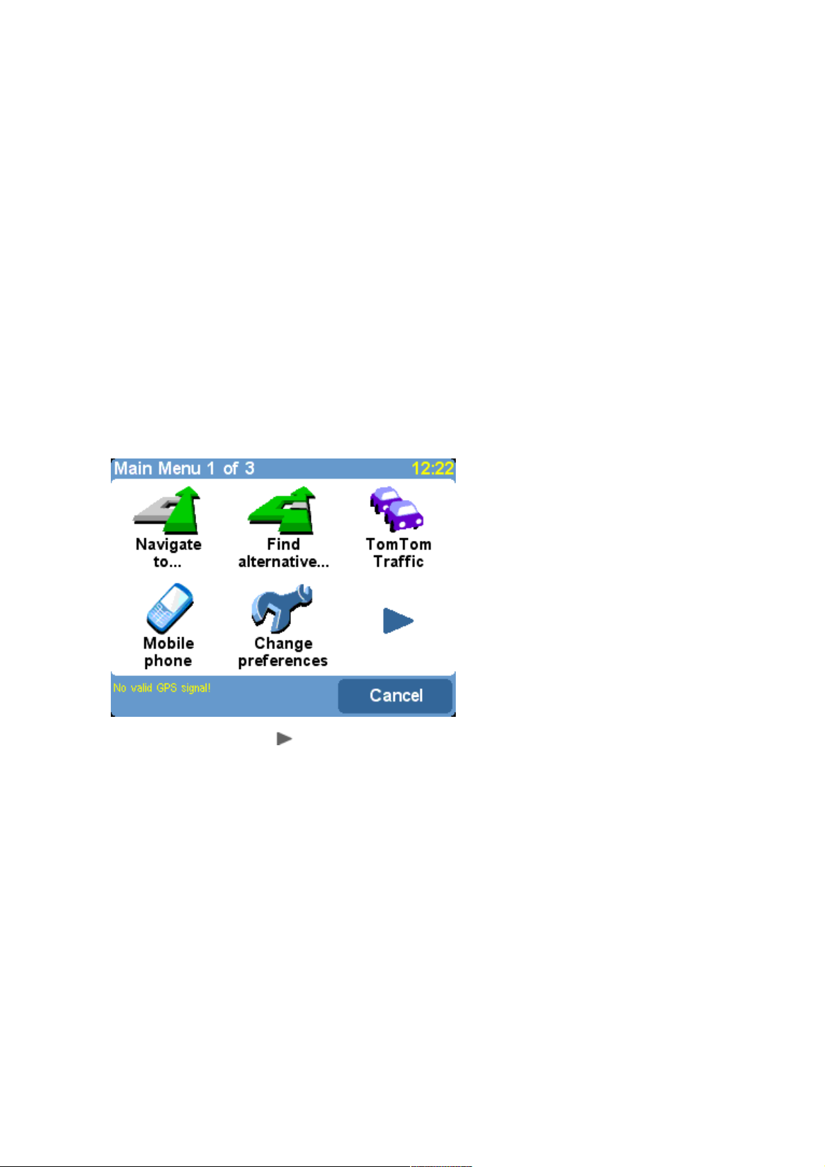
Everything on TomTom GO can be accomplished easily using just your finger on the touchscreen.
Note: you can bring up the main options menu by tapping your finger somewhere in the middle of
the screen.
As with many of the menus in TomTom GO, there are more options than can be shown on
one screen. Try tapping on a few times, to cycle through all the different things you can
do.
How to plan your first routeHow to plan your first route
1. Move outside, if you haven't already done so, so that the GPS hardware can locate your
position. This may take some time, and will happen more quickly if you remain still. The screen
displays your current position on its map, represented in a '3D' navigation view, from a driver's
perspective. When you start moving, the navigation view will match the streets outside as you
would see them through your windshield.
Page 2

Your position (and direction) is indicated by the icon.
2. Bring up the main menu. Use a few times to browse through all the different things you can
do, then choose 'Navigate to...' to start planning your first route.
Tip: Don't worry if some of the icons are 'grayed out', this just indicates that these menu options aren't
available yet. E.g. as you haven't yet planned a route then 'Find alternative...', 'View route' and 'Clear
route' are all grayed out.
Remember that always means that there's more to see on the next page, in this case
extra ways of choosing a destination.
3. Choose 'Address' . You'll see a standard keyboard, used for entering place names (e.g.
towns, streets and favorite locations). Above the keyboard is a small browser window in which your
TomTom system will display locations from its database.
4. The best way to see how your TomTom system works is to use it for real, so think of the
address that you want to visit and enter the first few letters. Be as specific as possible. As you
type, the letters are compared to the built-in list of possible names and any matches appear in the
browser window.
Page 3

Quick-matching a town name. Use and to scroll through other possible matches. If
you make a mistake, use to delete the last letter entered.
5. When you see the name of the place you want, select it. A new browser window is now shown,
this time with the prompt 'Street:' at the top. As before, start entering the road name of your
destination.
Quick-matching a street name. In cases where there is more than one road of the same
name, additional information is displayed to help you choose the correct location.
6. When you see the name of the street you want, select it. A third and final keyboard and browser
are shown, this time for you to select a house number. For some roads (such as those that don't
have house numbers), you'll be asked to select a particular 'Crossing:' (i.e. an intersection). Select
a crossing, or enter the house number and then choose 'Done'.
If you'd rather pick a crossing than a house number, select the 'Crossing' button.
Page 4
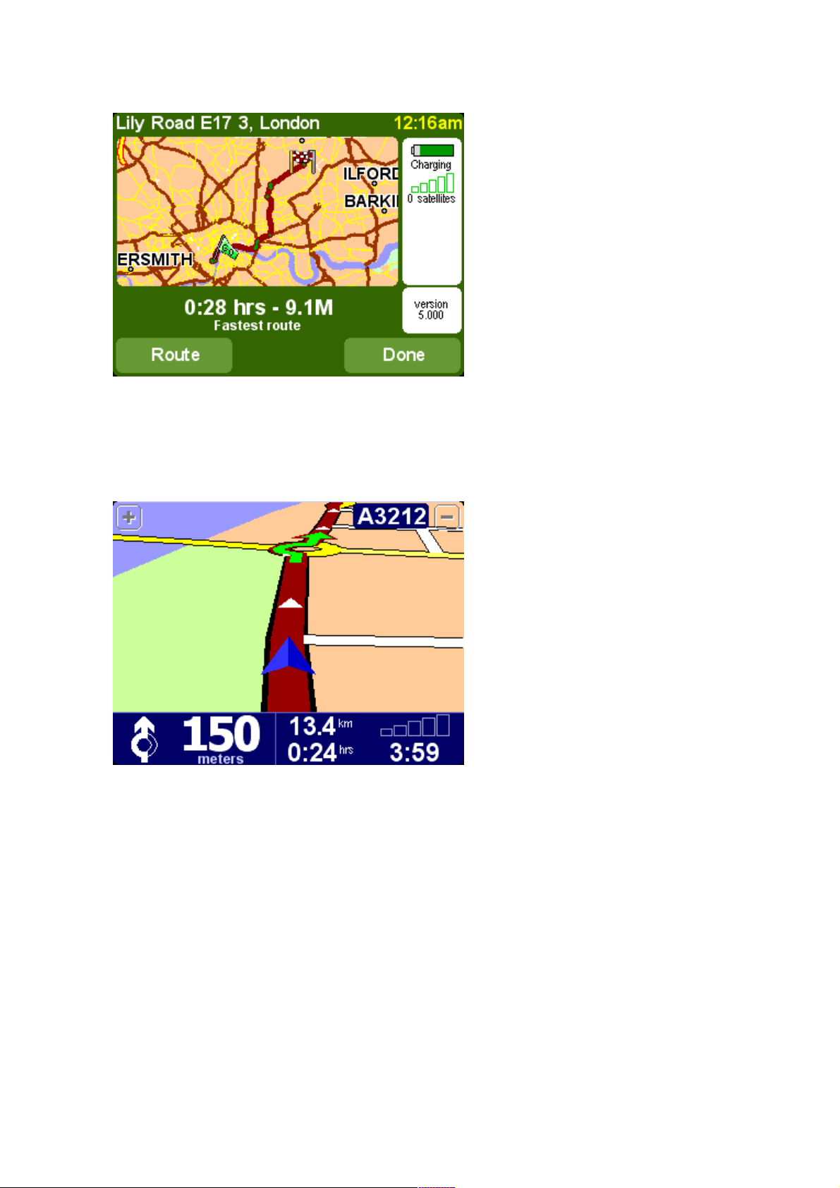
7. The fastest route from your current position to your destination is then calculated. This should
only take a few seconds and its progress is shown on the screen. When done, a summary is shown,
on a suitably scaled map.
Studying this summary can be useful for you to get a feel for your journey’s scope and to
check if the route includes roads that you’d rather avoid (in which case, see ‘Find
alternative’, below).
8. Select 'Done' and you'll find yourself back at the main navigation view, but with the route now
clearly colored in for you.
White arrow heads show the direction you need to move along the current road and a
specially-shaped green arrow shows what to do at the next turn or intersection.
Helping with your journeyHelping with your journey
The planning's all done; now just buckle your seat belt and drive. As you approach a specific turn in
the calculated route, your chosen voice will tell you what to do. For example, "In 100 meters, turn
left", followed by "Turn left", without you having to take your eyes off the road. As you travel,
following the voice instructions, you'll notice that the navigation view is updated constantly, always
showing coming roads and junctions and presenting the best route to you.
Don't worry if you miss a turn or drive down the wrong road. A new fastest route will be calculated
automatically, based on your new position and direction of travel. Wherever you go, it will always
give you instructions that will take you to your chosen destination.
What's on the screen?What's on the screen?
Much of the information on the main navigation view is configurable (see the 'Preferences' chapter
for details). By default, you'll see something like the illustration below.
Page 5
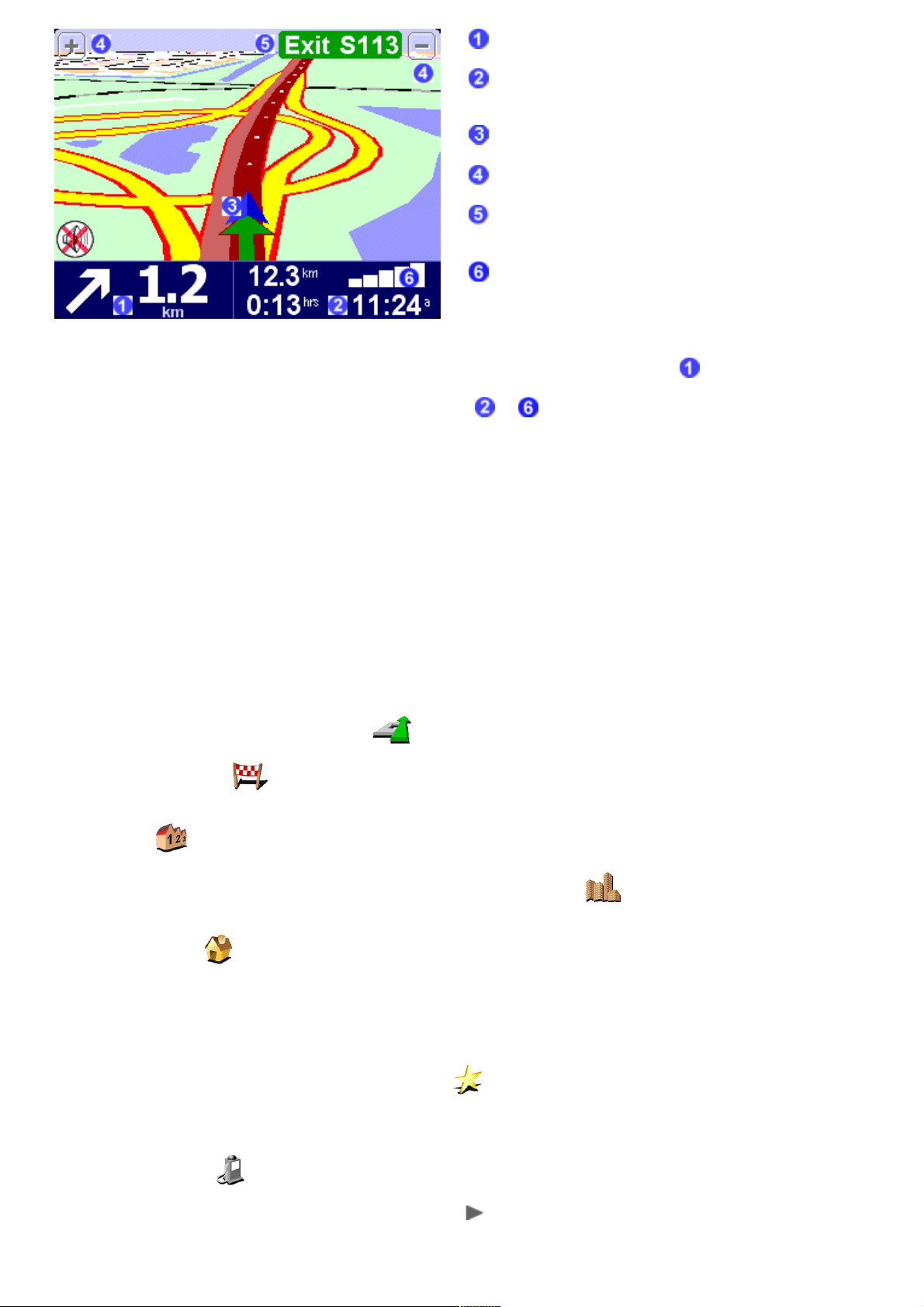
Your next turn instruction.
Configurable journey information including arrival time,
time to destination and distance to destination.
Your current GPS position.
'Zoom out' and 'Zoom in' buttons.
'Next highway' indicator, if applicable. See 'Name
preferences', if you want to turn this off.
A ‘phone-style’ signal indicator to give an idea of how
good or bad the GPS reception is in your current location.
The more bars, the better.
If you miss a voice instruction, tap on the turn instruction in the bottom left hand corner ( ) to
generate a new one. And if you'd like to view the route summary again, tap anywhere in the
journey information panel in the bottom right hand corner ( or ).
Most of the time, the voice and turn instructions are all you need to navigate successfully, which
means never having to take your eyes off the road. At complicated junctions, where simple
instructions aren't adequate, the navigation view comes into its own. A quick comparison between
the screen and the world in front of you should be all you need.
Tip: No instruction is shown or spoken at junctions which require no action. In towns and cities
especially, don't be concerned that you are passing side-roads and driving through intersections without
any instruction.
NavigationNavigation
Navigate to...Navigate to...
This is the simplest and most useful starting point in most situations. Given your current GPS
position, you can use this to navigate to any given address, crossing, favorite location, Point Of
Interest, and so on. Select 'Navigate to...' to bring up its first options screen.
'Recent destination' is a useful time-saver, displaying a list of addresses, Points Of Interest
and other destinations that you've used before.
'Address' displays the same city/street grids that you used in 'Planning your first route', so
just choose your destination in the usual way. If you're not sure of the exact street name to type in,
note that simply entering the city's name again (or using the 'City center' option, described
below) will get you to the geographical center of the city.
Choosing 'Home' here is quick and obvious, though if you chose not to set a home location
when setting up your TomTom system then this may still be grayed out. For more on setting up a
home location, see 'Home preferences'.
Although you're going to be navigating to many places you don't know well, there will also be a
number of locations that you visit frequently and that you want to be able to travel from (and to)
without having to enter their address details each time. These are your 'Favorites'. See 'Favorite
locations' for more on setting these up. Use 'Favorite' to navigate to such a location.
Note: 'Favorite' will be grayed out and unavailable if you haven't set any favorites yet.
'Point of interest' is your way into the huge database of railway stations, restaurants, gas
stations, ATMs, and so on. Choosing this will display icons for the five categories that you use most
often. If the one you want now isn't shown here then use to bring up a browser with all
categories that are available.
Page 6
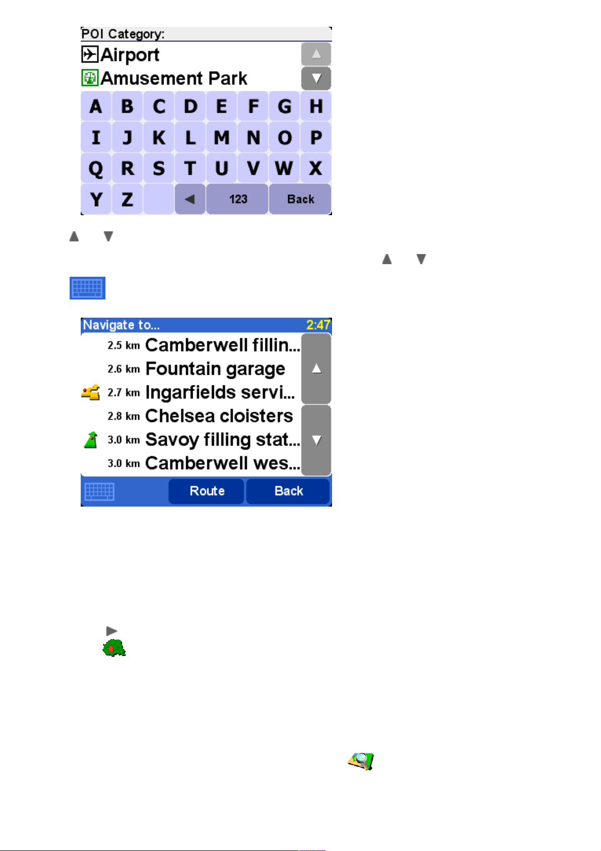
Use and to scroll through the list or enter a few letters of the required category's name.
When you see the category you want, select it, to bring up a list of all Points Of Interest in that
category, sorted according to their distance from your current position. Use and to scroll
through the list or, if you know the name of the Point Of Interest you want, choose the keyboard
icon and then enter a few starting letters.
There are several icons used beside Points Of Interest in the list. A straight green arrow
means that the POI is on your route; a bent green arrow means that a small detour from
your route is needed to reach it; a bent yellow arrow means that this POI needs a bigger
detour from your route; finally, with no icon shown, the POI is not on your route at all.
Finally, select any Point Of Interest to make it your destination.
Tip: Some of the more specialized Point Of Interest categories (e.g. 'Place of worship', 'Theater') may
contain information only for major cities.
By selecting in the 'Navigate to...' menu, you can view even more navigation options. Choose
'ZIP code' if you know this information for your destination and would prefer to enter this
than use the town or city name. Once you've selected a ZIP code in the browser, you'll be asked to
choose a street name (if needed) and house number in the usual way.
Tip: You can change your mind and start entering the town name after all. Or indeed start entering a
ZIP code in the main Address browser. It really is up to you. Note that full ZIP code support is only
available for the UK and the Netherlands.
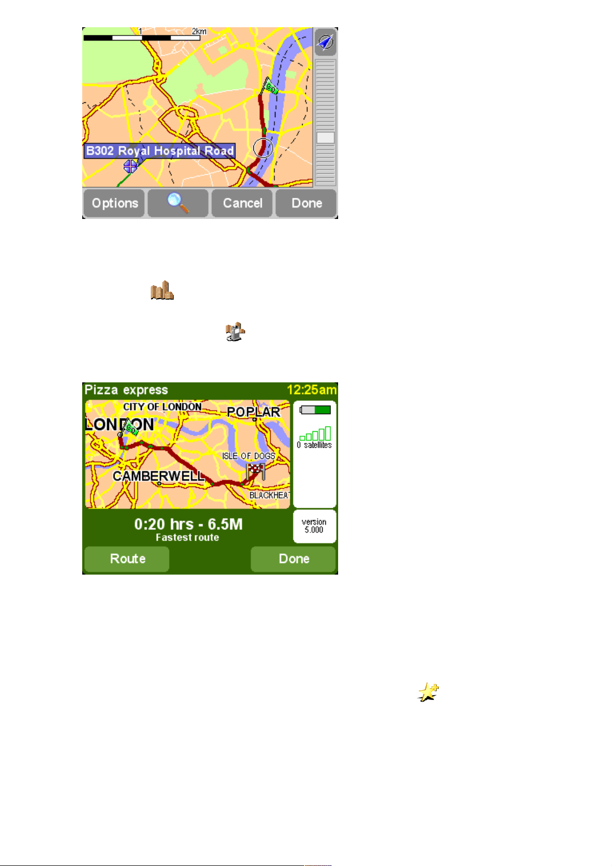
If you're good with maps and you'd prefer to pick a destination by eye, or if you're simply not sure
of a valid street name or ZIP code to enter, choose 'Point on map' . You can then scroll
around the map, zooming in or out as needed. Finally, select a point on the map as your destination
and use 'Done'. For more information on using the TomTom map browser, see the chapter on
'Maps'.
Page 7
On TomTom GO or TomTom Navigator, you can 'drag' the map to scroll it in any direction or
drag the zoom control up or down to zoom out or in. TomTom MOBILE users should use their
D-pad and Enter keys.
When traveling into an unfamiliar city, you might not know a destination road name, of course.
Choose 'City center' to automatically navigate to the geographical center of any city name
entered in the usual way.
In a similar way, choose 'POI in city' to navigate to a Point Of Interest in an unfamiliar city
(e.g. a Hotel or Parking Garage). Choose a city name in the usual way and then a Point Of Interest
category. The possible POIs are automatically sorted by proximity to the center of the chosen city.
Once planned, a summary of the calculated route is shown on a suitably scaled map. Select
'Route' to explore the route in various ways. See 'Advanced route planning' for more details.
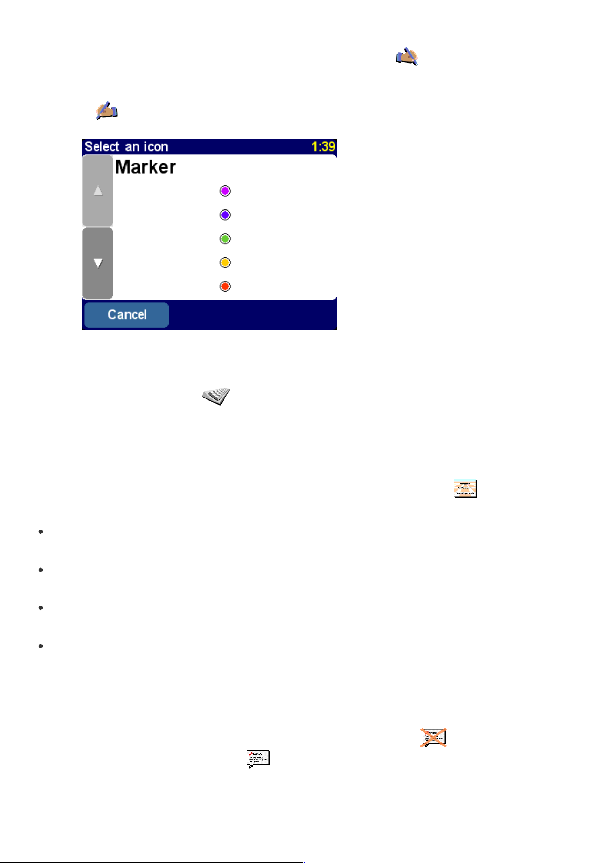
Favorite locationsFavorite locations
Add favoriteAdd favorite
'Favorites' are locations that you visit frequently and that you want to be able to travel from (and
to) without having to enter their address details each time. Select 'Add favorite' to bring up
its first options screen.
Page 8
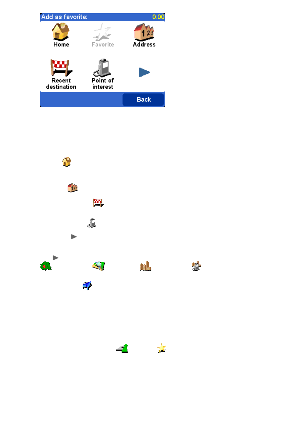
You'll notice that the 'Add favorite' choices are very similar to those for 'Navigate to', in the
last chapter. Whichever option you use, once the location has been chosen, you'll get the
chance to enter a name for the favorite (e.g. "Steve's house", "Office", "Uncle Fred")
Tip: When naming a favorite, the letters you enter automatically replace the highlighted suggestion. If
you just wish to add a letter or two to the supplied suggestion, first either tap on the highlighted words
(TomTom GO and Navigator users) or use Navigator right (TomTom MOBILE users).
Choose 'Home' to add your 'home' location to your favorites list, for extra convenience. If
this option is grayed out, it means that you haven't chosen a 'home' location yet. See 'Home
preferences' for more details.
Choose 'Address' to add a specific address as a favorite.
Choose 'Recent destination' to add a favorite from a list of addresses, Points Of Interest
and other destinations that you've used before.
Choose 'Point of interest' to select a POI from the built-in databases as a favorite. As with
navigating to a POI, you'll first see the five categories that you use most often, if the one you want
isn't shown then use to bring up a browser showing the full list. Within each category, you'll see
a list of all POIs, sorted according to their distance from your current position. Simply pick the one
you want to make a favorite.
By selecting , you can view more options for picking a location as a favorite. Choose from 'ZIP
code' , 'Point on map' , 'City center' or 'POI in city' , in exactly the
same way as you would for setting each as a destination in the previous chapter.
Choosing 'GPS position' is very useful when you want to store your current location quickly.
For example, you are passing something interesting and want to return there later. Since you don't
need to find the location by address, it is also one of the fastest ways of adding a favorite, so
consider using this whenever you visit somewhere that you know you'll want to return to at a later
date.
Tip: You don't have to travel, physically, to a location in order to set it as a favorite! Instead, see the
'Cursor functions' in 'Browse map'.
Once a favorite has been chosen and named, it will show up whenever you pick from your list of
favorites, for example in 'Navigate to...' 'Favorite' .
Advanced route planningAdvanced route planning
Find alternative...Find alternative...
Maybe a route has been planned that you're not happy with? Perhaps you have been routed through
a busy area? Have you spotted roadwork up ahead? Or perhaps you really wanted to go 'via' one
Page 9

particular location? This is where the 'Find alternative...' option comes in.
Choose 'Travel via...' if you want to make sure the planned route goes past one particular
location, perhaps to pick up or drop someone off. The new location is picked in exactly the same
way as you would pick a departure point or destination, with the usual options of 'Home', 'Favorite',
'Address', 'Point Of Interest', and so on. Once selected, a new fastest route is calculated, making
sure to include your 'via' location.
Tip: If you want to include more than a single 'via' location in your journey, use the comprehensive
Itinerary feature instead, described later in this chapter.
If you spot signs of trouble (such as backed-up traffic or 'Delays ahead' warning signs), choose
'Avoid roadblock' . To save you time (when you're on the road), there are four presets.
Estimate whether the blockage extends '100m', '500m', '2000m' or '5000m' ahead from your
current position and then select the appropriate icon.
Once you've chosen a roadblock option, a new route is quickly calculated that avoids all
roads for the chosen distance along the planned route, routing you right round the troubled
area.
Tip: After choosing a roadblock option, look out for a turn direction on the screen almost immediately.
If you continue into the 'blocked' area, you may want to use 'Find alternative...' and then 'Avoid
roadblock' again, to recalculate your best route taking into account your new position.
If you want to avoid a particular intersection, maybe because it's a known traffic black spot, choose
'Avoid part of route' . Use and to scroll through the current route instructions,
choosing which junction you want to steer clear of. A new route will then be calculated.
Note: Any junctions that have already been passed are grayed out and can't be selected.
Page 10
Finally, if you want an alternative route because you simply don't like the original, choose
'Calculate alternative' . As far as possible, a totally different set of roads is used. Once
planned, an overview is shown, as usual, and you can choose 'Route' for detailed instructions or
'Done' to switch back to the main navigation view. You can keep asking for (increasingly inefficient)
alternative routes using this method until the message 'No route found' appears. Choose
'Recalculate original' to return to the original best route.
TomTom Traffic
If you have enabled TomTom Traffic and have a valid subscription, you can also use the menu
option 'Minimize traffic delays' to recalculate a route to your destination that takes into
account all current traffic delays. See the chapter on TomTom PLUS for more details.
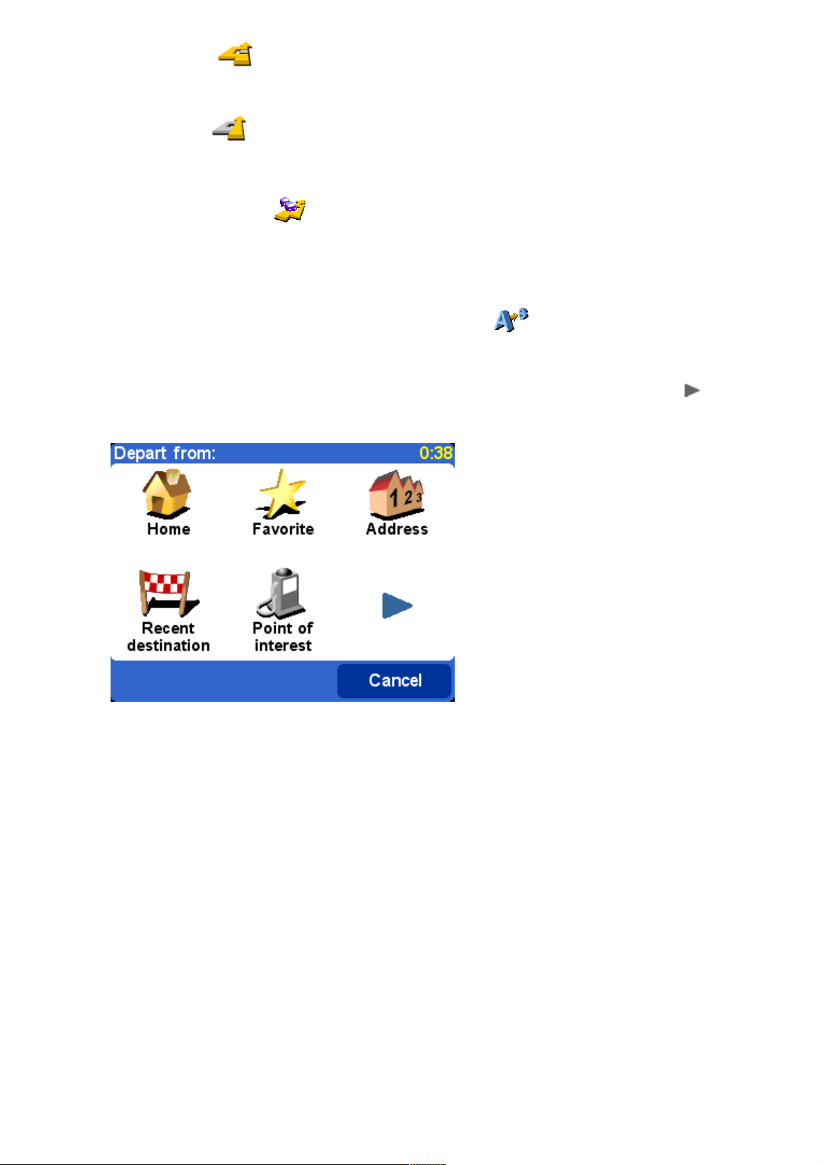
Advanced planningAdvanced planning
Although navigating from your current position is the function that you'll use most often, there may
be times when you want to plan ahead. Choose 'Advanced planning' to look at the best
route and journey time between any two given locations or perhaps to get directions that will help
someone else get to your current position.
Tip: If 'Advanced planning' is found on another screen in the main menu, you may need to use in
order to see it.
A familiar options screen, but this time asking where you want to depart from (a question
which obviously wasn't needed when using 'Navigate to...')
Select your departure location in the usual way. You'll then be asked to 'Pick a destination', again
with the usual choices. Finally, there's an extra question to answer, since you may be creating this
route for someone else. Choose between 'Fastest route', 'Shortest route' (for motor vehicles),
'Avoid highways', 'Walking route' (i.e. the shortest route, ignoring all traffic rules and excluding
highways), 'Bicycle route' (i.e. the shortest route obeying traffic rules but still excluding highways)
or 'Limited speed' (the quickest route for a vehicle of limited top speed, i.e. many road types are
equally preferred, apart from highways).
Page 11
If you'd like this choice every time you navigate, or if you'd like to change the default
setting, see 'Planning preferences'.
Once planned to your preference, the best route is shown on a suitably scaled map. As with
'Navigate to...', you can now select the 'Route' button to explore the detailed route instructions, as
detailed in 'View route' below. Finally, select 'Done' to return to the main navigation view.
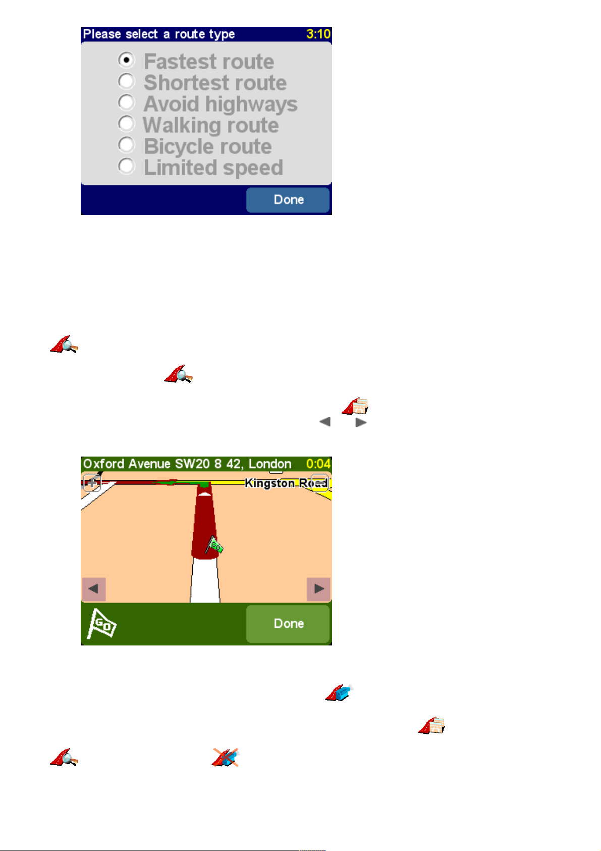
View routeView route
If you already have a route planned, you can explore it in various ways by choosing 'View route'
.
Choose 'Browse as text' for a simple list of the junctions involved and the distances (or
times, use the 'Options' button to change the numbers shown) between them. Selecting an
individual junction from this display or using 'Browse as images' instead presents each
junction in 3D, with your turn instruction clearly marked. Use and to move backwards and
forwards through your planned route.
'Browse as images' is a quick and powerful way to get a feel for the route you're about to
travel.
Along similar lines, although animated, is 'Show route demo' . Using this feature, you can
view your journey at anything up to 500% of 'real time' (chosen using a simple slider). This works
well for journeys within a town or city, but you'll prefer to use 'Browse as images' ,
mentioned above, for any journey of significant length. To stop the animation, choose 'View route'
and then 'Stop route demo' .
Tip: When browsing a route as images, tap on the centre of the screen to switch between 2D and 3D
views of each junction (not TomTom MOBILE users).
Page 12
Finally, you can view your planned route on a traditional top-down map. Choose 'Browse map of
route' to overlay the route onto a map that you can zoom and scroll around. See the chapter
'Maps' for more details of using this screen to your advantage. Or choose 'Show route summary'
to display again the graphical overview of your route that was shown when it was first
calculated.
Clear routeClear route
Choose 'Clear route' if you'd like to remove the currently planned route from all views. From
here on, your position will still be tracked on the map, but no instructions or guidance will be
provided.
Tip: You do not need to clear a route before planning a new one: this happens automatically.
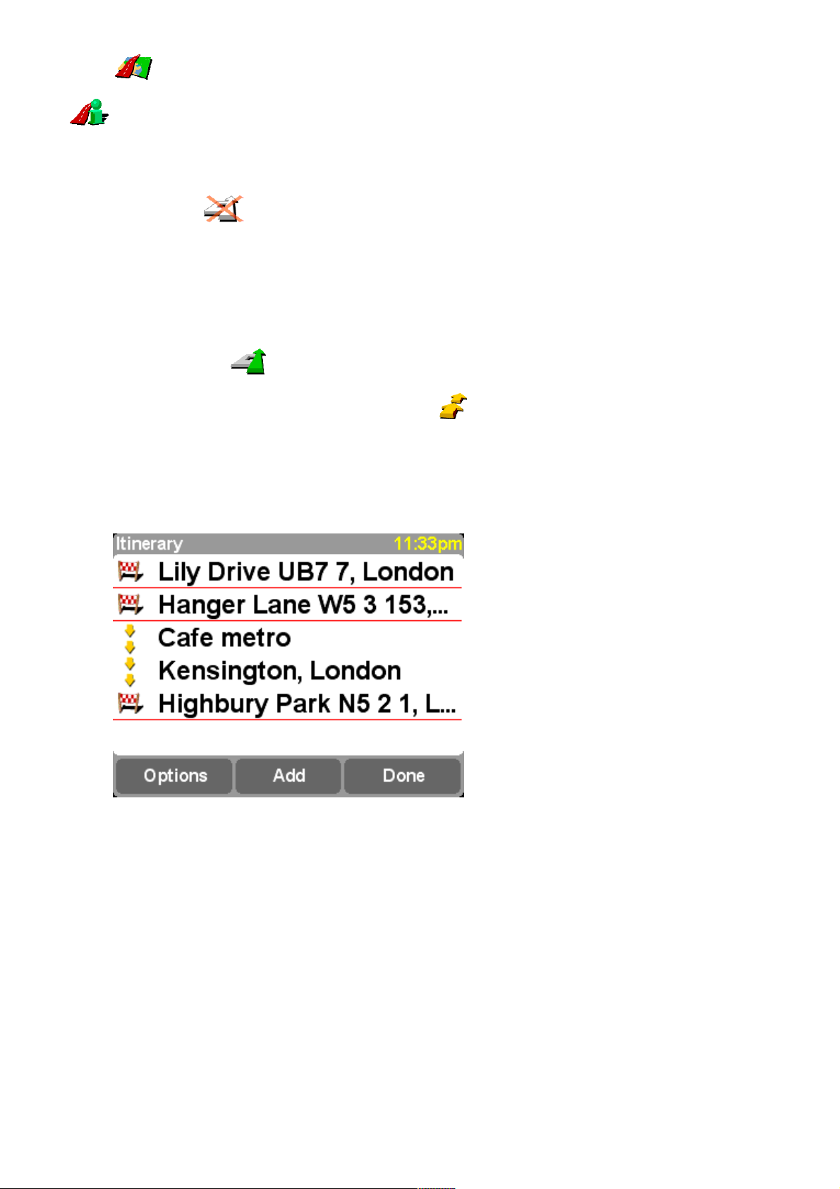
Itinerary planningItinerary planning
Although 'Navigate to...' is fine for casual travel, it may be that you're planning a journey
that's more ambitious. You may even want to save the details of this journey for future use or to
pass them on to other users. Choose 'Itinerary planning' to create a new itinerary or
amend an existing one.
An itinerary is essentially just a list of 'waypoints' and 'destinations'. Your best route is calculated,
visiting each in turn (in the exact order you specify). In general, you'd add a 'destination' when you
wanted countdown information to arrival on the main navigation view, otherwise you'd add a
location as a 'waypoint' that simply has to be traveled through (i.e. it's the 'way you want to go').
A typical itinerary, showing both waypoints to be traveled through and destinations you want
to arrive at.
When first started, the itinerary planner will be empty, of course. Use 'Add' to select locations in the
normal way, choosing from 'Home', 'Favorite', 'Address', 'Recent destination', and so on. Each
location will be added as a waypoint if the previous one was also a waypoint, otherwise it will be
added as a destination.
Page 13

Note that the exact menu options shown here will change depending on whether the current
itinerary entry is a waypoint or destination, and on whether it has been visited already.
You can manage an individual entry in an itinerary by selecting it, and going to the waypoint menu
(above). Use 'Mark as waypoint' to change the entry from a destination to a waypoint, or
'Mark as destination' to change it from a waypoint to a destination.
Use 'Mark as 'visited'' to mark this itinerary entry and all preceding ones as completed, so
that navigation will continue from the next (unvisited) entry. You can even go back and travel part
of an itinerary again by selecting somewhere you've already been and using 'Mark as 'to visit''
, in which case this and all following itinerary entries will be included in navigation again.
'Delete item', 'Move item up' and 'Move item down' are self-explanatory.
If you want to save your itinerary for re-use in the future, or if you want to load a previous itinerary,
choose 'Options', using 'Save itinerary' or 'Load itinerary' respectively. When
saving, you can enter a name for the itinerary using the standard on-screen keyboard (by default it
takes its name from your last destination).
By saving your itineraries, you can re-use them at a later date without having to re-enter
any of the locations. Use this screen to save, load or delete an itinerary, or to start a new
one.
Select 'Start navigation' on the 'Options' menu to start navigating.
TomTom PlusTomTom Plus
Connecting to your phone (GO users only)Connecting to your phone (GO users only)
Page 14
If you have a Bluetooth-capable mobile phone then you can use your TomTom GO to access
TomTom PLUS services.
Note: Visit www.tomtom.com for a list of compatible Bluetooth-enabled phones.
If this is the very first time you have used TomTom GO with your phone and there are a few steps
needed to 'pair' the two devices, i.e. make a connection.
1. Select ‘Connect to your phone’ .
2. Pick your phone from the list displayed.
3. When prompted to connect, enter a pass code (password) of ‘0000’ on the phone.
4. You will then be asked to set up a wireless Internet connection. Do this if you want to use TomTom
PLUS services.
Tip: To allow automatic connection from now on, make the TomTom GO a ‘trusted’ device on your
phone. See your phone manual for details.
About TomTom PLUSAbout TomTom PLUS
Our optional TomTom PLUS service can give you real time information on traffic congestion, helping
you route around it. In addition, there is current weather information for any location on your map,
plus special downloads, including detailed city maps, extra voice files and extra POI databases.
To use TomTom PLUS, you need:
A GPRS-ready mobile phone with Bluetooth.
An email address.
Your TomTom product code (found on the card in your box).
(If you already pick up email or browse the Internet on your phone, then it's probably already
GPRS-ready; if you're not sure, ask your network provider.)
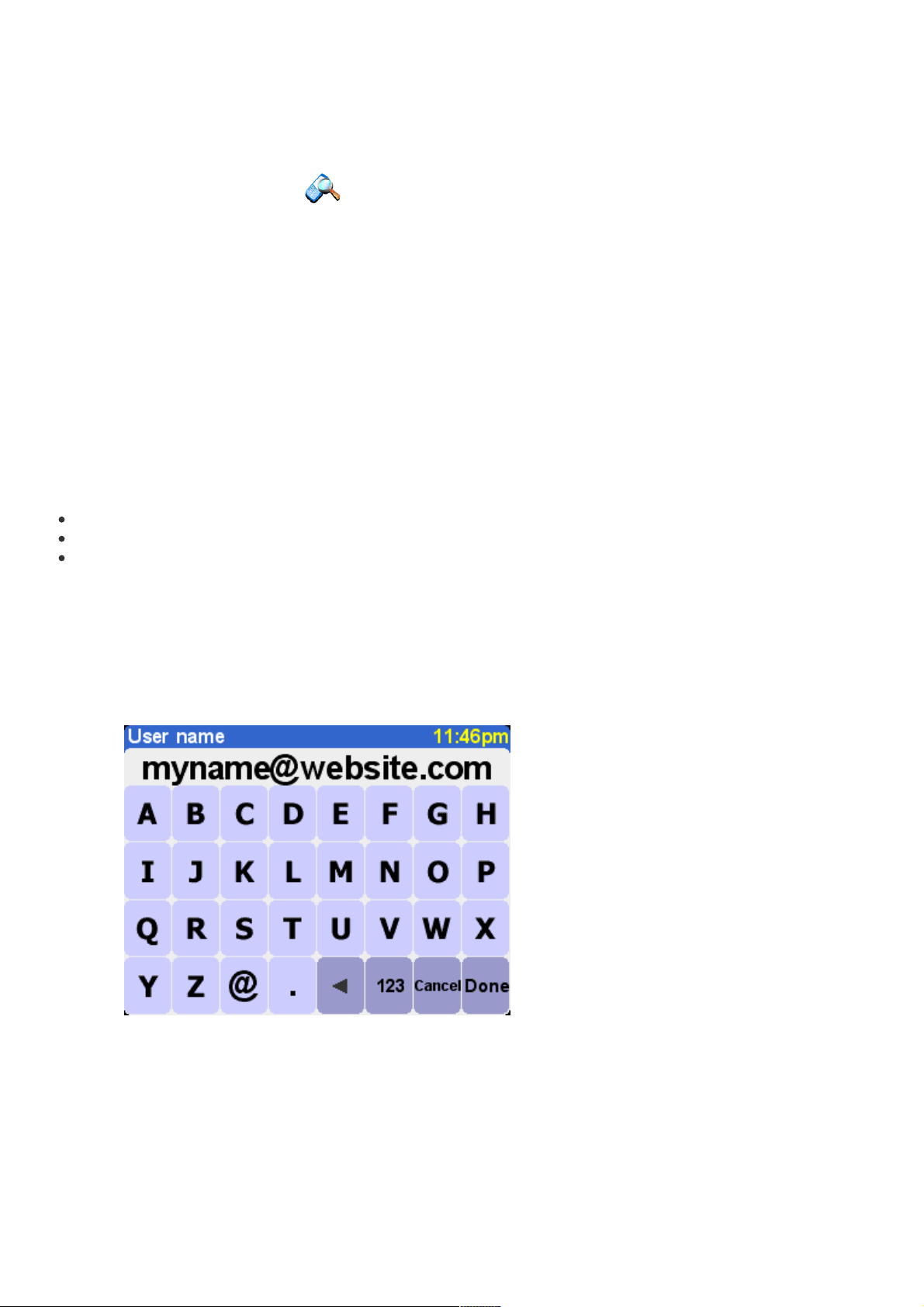
You'll be taken through the very brief sign-up process when you try to use any of TomTom PLUS's
services for the first time. Enter your email address as your TomTom PLUS user name and the
TomTom product code as your password (without any spaces). That's it! You can now use any of the
extra services.
Enter your e-mail address.
Page 15

For free trial enter !PLUS! or your own password.
You'll now receive an email with your user name and password, giving you access to the member
area of the TomTom PLUS web site. You can then go to www.tomtom.com to purchase subscriptions
and find out about offers and free services that are available for your product.
TomTom TrafficTomTom Traffic
Tip: TomTom Traffic has been designed to retrieve traffic information over a GPRS connection. Do not
use it with a GSM data connection, as this can lead to substantial communication costs.
Note: Due to its dynamic nature, traffic information can by definition never represent the full, current
traffic situation. There are locations for which information is not available, and some delays might not
be detected on time. Quality, coverage and reporting times will differ from one region to the next.
Choose 'TomTom Traffic' and then 'Enable traffic' to switch on the main TomTom
Traffic service and the other related route planning and map display functions. If there is traffic
information available for your area, TomTom traffic will stay enabled until you choose 'Disable
traffic' later on.
Select 'Update traffic info' to download the latest traffic information for your area (if
available) from the TomTom Traffic Internet server, using your phone's GPRS data connection. Back
in the main navigation view, you'll notice a new traffic 'route bar' on the right hand side of the
screen. In the top right corner is a special animation, which TomTom Traffic uses to show you its
current status:
Page 16

Traffic information is being updated
Traffic information was updated less than 10 minutes ago
Traffic information was updated less than 20 minutes ago
Traffic information was updated less than 30 minutes ago
Traffic information was updated less than 40 minutes ago
Traffic information was updated more than 40 minutes ago
If the color of the indicator turns yellow, this means there is more up-to-date traffic information available on the
server for you to download
The connection to the TomTom Traffic server failed. Try choosing 'Update traffic info' again. If it still fails, it's
probably for one of the following reasons:
GPRS settings incorrect. Ask your network provider for help with your phone's settings.
The account is registered for another device. Select 'New device' in the 'My Traffic' section of 'My TomTom'
on www.tomtom.com and try again. (You can only use your Traffic account on one device at a time.)
Your subscription has expired. In the Traffic section of 'My TomTom' you can look up details of your traffic
account and extend your subscription.
If you have a route already planned, you'll also be able to use the route bar, beneath the TomTom
Traffic status animation. Imagine the bar, from bottom to top, represents the remainder of your
journey. Traffic delays are then shown at the relative points along the route bar, so that you can see
what obstacles are ahead of you. TomTom Traffic uses a variety of different delay icons, as shown
below:
Traffic delay Road work Avoided traffic delay
Accident One or more lanes closed Fog
Traffic jam Road closed Rain
Wind/Storm Snow/Ice/Hail
You'll see these same icons used in more detail within the main 'TomTom Traffic' system.
Use the menu option 'Show traffic info' to display an overview of all delays on your planned
route. In addition to the icons above, the overview also shows three different road patterns:
(slow traffic), (stopped traffic) and (road works).
Page 17

A typical TomTom Traffic overview. Choose 'Update' to get the latest traffic information from
the TomTom server.
Selecting 'Replan' will calculate a new best route for you, automatically taking into account the
delays and their severity. For clarity, delays on the overview are shown as simple red circles. If
you'd like more details, you can use ( and) to scroll through the delays, one by one.
The number (e.g. 1st of 17) in the title bar indicates which delay you're viewing along your
route.
Note: A planned route may still take you through a traffic jam if this is still considered to be the fastest
way to your destination (i.e. faster than less congested alternatives).
Tip: As an alternative to using 'Replan' on the TomTom Traffic overview screen, you can use 'Minimize
traffic delays' on the 'Find alternative' menu.
Instead of being restricted to the scope of a particular route, you can also choose 'Browse map'
to view all traffic delays applicable to your local map. As usual, you can scroll around and
zoom in and out, to see any area in detail.
Page 18

As you zoom further into the map, TomTom Traffic will change delay indicators into detailed
icons, giving you more information. If you select an individual delay, full details will be shown
in the same way as within Show traffic info above.
Depending on your GPRS rate with your network provider, you may want to use 'Change Traffic
preferences' to automatically keep TomTom Traffic (and your route) updated while you're
on the road. For full automation, tick 'Automatically update traffic info while on route' and
'Automatically optimize the route after every update'. You'll probably also want to tick 'Beep
when route traffic situation changes', to receive an audio warning when the update takes place
and a new traffic situation is reported.
Traffic on My TomTom
By going to the Traffic section of 'My TomTom' (www.tomtom.com), you will be able to:
find information on setting up and testing a GPRS connection.
subscribe to free trial subscriptions.
purchase traffic subscriptions.
look up your traffic login and password, and the expiry date of your traffic subscription(s).
download the latest software version, if relevant.
reset your account so that you can use it on another device.
find out about the latest TomTom PLUS services.
TomTom WeatherTomTom Weather
Choose the main menu option 'TomTom Weather' to get information about of the current
weather at any location, selected using the usual destination options. Using your configured wireless
GPRS Internet connection, TomTom looks up weather information from thousands of weather
stations around the world (located at airports), presenting the most suitable to the selected location.
Page 19

The weather information available includes:
Cloud cover (clear sky, clouds, overcast)
Precipitation intensity (light, moderate, heavy)
Precipitation type (rain, snow, hail)
Temperature (in Celsius and Fahrenheit)
Wind direction and force (in Beaufort and mph)
Lightning (yes/no)
Humidity (percentage)
Visibility (in meters/kilometers or feet/miles)
Download extrasDownload extras
In addition to the two dynamic services above, you can also download many extras, such as new
sets of Points of Interest, new voices, etc. The items that appear for download could include some
extra, free items (available for everyone), as well as the items you've already purchased (so you
can reload them if needed) and a limited number of 'premium' items (during an initial period). The
list of items that appears on your device will vary according to the number of free premium items
you have ‘used up’ during your initial period. You can purchase more premium items at any time
from www.tomtom.com.
Start by choosing 'Download extras' from the main menu.
Download a map
Choose 'Download a map' to grab a map of a city that didn't already come with your
TomTom system. For example, if you're planning a weekend or city trip, you can download the city
map for your destination. Follow the prompts, choosing a country and then searching for the city
you want.
Page 20

Some of the matches may be marked as '[big]' or '[free]', indicating that they're either too
large to comfortably download over GPRS or that they're free to all (so you don't have to
worry about downloading them within your initial period).
Tip: City maps can be large in size. For bigger cities we advise you NOT to download the maps directly
to your device since the costs for the GPRS data session can be significant. For these larger maps, it’s
better to download them first on your desktop computer and then transfer them using your usual
connection.
Here we're about to download a city map. Note that you will be warned if there’s not enough
space on your device to download the area or city chosen.
To start using your newly downloaded map, use 'Manage maps'.
Download POI
Downloading a new set of Points Of Interest is very similar. Use 'Download POI' . Only sets
that are free, part of your purchased system or available under an initial period will be listed.
Page 21

Once downloaded, you can navigate to POIs in the new sets in the usual way, or opt to
display them on your maps using 'Show POI' and 'Manage POI'.
Download voice
Your TomTom system comes with a number of voice options you can choose from to guide you
during navigation. With TomTom PLUS you can download new voices to find one that suits you
better (or just for fun). The digital voice sample files are larger in size, and shouldn't normally be
downloaded directly to your device using GPRS. Use your desktop's fast Internet connection, logging
in to www.tomtom.com, then transfer the voice files using your USB cable instead. Once
downloaded, use 'Change voice' to start using the voice samples in navigation.
As before, only free voices or premium voices that you have already purchased or that are
part of your bundle will be listed.
Download map colors
Your TomTom system comes with a number of different map and navigation color schemes, to cater
for personal preference, regional differences and night/day use. Use 'Download map colors'
to see the extra schemes available on TomTom PLUS.
Once downloaded, use 'Change map colors' to browse to and select a new color scheme.
Download update
Choose 'Download update' to check for application updates for your TomTom system. If
one is available, depending on the size, it may have to be installed via your desktop computer.
Edit service account
You can use 'Edit service account' to enter updated TomTom PLUS username and
password details if you have changed them to something more memorable on www.tomtom.com.
Note: TomTom PLUS services vary by country and are updated regularly. Please visit
Page 22

www.tomtom.com frequently to find out about new premium content and bundle offers.
Note: The use of TomTom PLUS services does not take into account the cost of GPRS data
calls from your device. Please check your network operator for cost details.
MapsMaps
The digital maps form the basis of everything your TomTom product can do and many functions
make use of the map browser. This chapter explains how to move around in the browser and how to
use it to set up destinations and search for things.
Browse mapBrowse map
Choose 'Browse map' now, to get started in the map browser. The map view is oriented in
the same way as a paper map, i.e. with north 'upwards', and shows the usual cities, towns, major
roads, streets, railway lines, rivers and lakes. Unlike a paper map, you can zoom in and out and
vary the amount of detail shown. You can also overlay categories of Points Of Interest, Traffic
information (if subscribed) and personal elements such as favorite locations and
departure/destination points.
The main elements of the map browser are:
Scale bar
Cursor position
GPS button, choose this to re-center the map on your current
GPS position
Zoom bar
Your current GPS position
Options button (described below)
Search button (described below)
Cursor button (described below)
A Point Of Interest, these will appear according to your own
preferences.
Note: The appearance of the map and its associated controls will differ slightly when using live Traffic
information (dimmed main colors, highlighted traffic delays). In addition, TomTom GO remote control or
TomTom MOBILE users will see just two buttons, 'Options' and 'Done'. In these cases, choosing
'Options' brings up extra controls, including 'Use cursor...' and 'Find'.
Scroll around a map by dragging it with your finger (TomTom GO users), stylus (Navigator users) or
by using your Navigator key (TomTom MOBILE users). Maps will usually be scaled for you, perhaps
to encompass a recently-calculated route or to show details of a particular junction, but you can
adjust the scale yourself if needed. If the zoom bar is showing, simply drag its handle up
and down slowly. The map will be continuously zoomed in (when sliding down) and out (when
sliding up) around the current cursor position. If the zoom bar is absent (TomTom MOBILE users or
when TomTom GO is used with the optional remote control), press 'OK' to access the zoom
functions.
Tip: Only a 'blocky' preview map is shown while you're changing the zoom level. The moment you lift
your finger, the map is drawn properly in full detail.
Cursor functionsCursor functions
The cursor is the most valuable tool in the map browser. Select any spot on the map to place
the cursor there. You can then do things with the current cursor position by using the cursor
function .
Page 23

After positioning the cursor, the nearest road segment is automatically highlighted in green
and labeled, together with start and finish house numbers on each side of the road segment
(if relevant).
Choose 'Navigate there' to plan a route from your current GPS position to the cursor
position.
Choose 'Center on map' to make the cursor position the new map center, i.e. with your
chosen spot in the center of the screen.
Choose 'Find nearby POI' to find the Point Of Interest nearest to the cursor position. As
usual, icons are shown for the five categories that you've used most recently, use to bring up a
list of all categories that are available. Within a category, use and to scroll through the list of
all Points Of Interest, sorted according to their distance from your cursor position. Choose the one
you want, to display it (or as near as it's possible to get to it using standard roads) in the centre of
the map screen.
Choose 'Add as POI' to add the cursor position as a new POI item in one of your own
categories. For example, adding a new company site to a 'Your offices' category. If you haven't yet
created any categories, you'll be offered the chance to create one now.
Note: You can't add extra Points Of Interest to the built-in POI categories.
Choose 'Travel via...' to create a route that includes the cursor position.
Finally, and perhaps most usefully of all, tap on 'Add as favorite' to set the current cursor
position as a favorite location. This can be invaluable for locations which don't have known or
recognized addresses.
Finding locations on the mapFinding locations on the map
Use the control ('Find') to scroll the map quickly to any specific location (Address,
Recent destination, POI, etc.) In addition to centering the map on your chosen location, the zoom
level is also reset to show the location in appropriately high detail.
Page 24

You'll be familiar with the types of location that can be found. Note that the 'Point Of
Interest' option finds and sorts items by distance from your current GPS position, not by
distance from the center of the map or from the cursor position. To find Points Of Interest
sorted by distance from the cursor position, see 'Find nearby POI' in Cursor functions, above.
Map optionsMap options
Use the 'Options' button to customize the level of detail shown on the map. (If using TomTom
MOBILE or the optional GO remote control, 'Options' is also your way into cursor and find functions,
with 'Change preferences' giving you the options below.)
The choices made here will apply to all future displays of the map view.
Clearing the 'Names' check-box (it's ticked by default) will stop the display of relevant town and
district names. Ticking 'Favorites' will pop up a yellow star for each favorite location (only on the
map view). If TomTom Traffic is enabled, note you can tick 'Traffic' to show current traffic
information on the map (whose appearance will be altered to highlight traffic delays).
You can turn on (or off) the display of 'Points Of Interest' on the map view by ticking its check
box. Which Points Of Interest are displayed depends on the categories you have chosen to show.
You can make this choice now, by selecting the 'POI' button, or later, using 'Manage POI' in
Preferences.
Switching mapsSwitching maps
Depending on which application package you purchased, there may be more than one map database
available. If so, you can use 'Manage maps' in Preferences to switch maps or even download a new
one.
PreferencesPreferences
You can change much of the look and feel of your TomTom system to your own liking by
using 'Preferences' . To see all the options described in this chapter, use to scroll
Page 25

through the different pages.
Note: The icons shown for some preferences will change, depending on the state the preference is
currently in. For example, choosing 'Turn off sound' disables the voice instructions. Once
disabled, the option and icon change to 'Turn on sound' , reflecting the action to take when next
selected.
Use night colors/Use day colorsUse night colors/Use day colors
Bright colors are normally used, with a lot of contrast, so that you can see the map clearly even in
bright sunlight. When it is dark outside, you may want to 'Use night colors' . The navigation
view will then be displayed (by default) using dark and subdued colors that will not interfere with
your night vision. In addition, the preference is changed to 'Use day colors' ; select this to
revert to the original color scheme.
These are the default night colors, but you can select any color scheme you like, for either
day or night use, by using the preference 'Change map colors'.
Turn off 3D display/Turn on 3D displayTurn off 3D display/Turn on 3D display
The main 3D navigation view, showing maps, routes and Points Of Interest from the perspective of
the vehicle driver, can be switched to a more conventional view. Choose 'Turn off 3D display'
to revert to an overhead 'plan' map, which is constantly rotated to keep your current
direction of travel pointing 'up' the screen. Choose 'Turn on 3D display' to return to the
original view.
In addition to the alternative 'plan' view shown here, there's also a simple 'schematic' view.
Page 26

Turn off map display/Turn on map Turn off map display/Turn on map displaydisplay
Above a specified speed, for safety reasons, the main map view can be replaced by a 'schematic'
view, focused on the next driving instruction. You can choose to use this feature by choosing 'Turn
off map display' . Select 'Above certain speed' to specify a cut-off speed, or 'Always' to have
the schematic view shown at all speeds. Choose 'Turn on map display' to always show the
map again.
Note the way the distance to the upcoming turn information is shown in the bottom-left of
the screen.
Hide POI/Show POIHide POI/Show POI
You'll find it useful to just show specific categories of Points Of Interest (POI) on the navigation and
map views, using the preference ' 'Manage POI'. Once you've spent time carefully browsing through
the categories and choosing the ones you need, you can hide all of them from the main navigation
view in one stroke with 'Hide POI' or show your preferred set again with 'Show POI'
.
Turn off sound/Turn on soundTurn off sound/Turn on sound
You can turn off the voice that gives navigation instructions by choosing 'Turn off sound' .
This is indicated during navigation by the icon in the lower left-hand corner of the screen. To
turn the voice instructions back on again, select 'Turn on sound' .
To change the volume of the spoken instructions, use 'Volume preferences'. To select another voice (i.e.
gender and/or language), use the preference 'Switch language'.
Volume preferencesVolume preferences
You can change the volume of the voice instructions by using 'Volume preferences' , with
its sliding scale to set the required volume in increments of 5%. The 'Test' function is a good way to
get the volume right before starting your journey.
You may also find it helpful to use 'Link volume to car speed', so that the voice instructions get
louder as road noise increases and are at their quietest when you are stationary.
Manage favoritesManage favorites
In time, you may want to use 'Manage favorites' to delete any favorite locations that are
no longer needed. You can also rename them, if you wish. Use and to scroll up and down the
list and pick the one you want to change or delete.
Page 27

You can back up your favorite locations by connecting your TomTom system to your PC or Mac. See
'Connecting to your PC' for more details.
Note: If you haven't added any favorite locations yet, the 'Manage favorites' icon will be grayed out
and unavailable.
Tip: The way to change a favorite's location is to delete the current instance and create a new one at
the correct location. See Favorite locations.
Change Home locationChange Home location
You can set or change your 'Home' location at any time by using 'Change Home location' .
You will then be able to select this later as a departure or destination point.
Tip: 'Home' doesn't necessarily have to be your physical home. Set it to the location that is most
central in your travels, for example: your office.
Manage mapsManage maps
If you have maps of another country or area installed, the preference 'Manage maps' will be
enabled. Choose 'Switch map' to switch to another map that's already available. The map
that you are currently using is highlighted in yellow, select the map you wish to use next.
Tip: If you want to switch to a map on a different memory card, just eject the current one and put the
new card in. (This doesn't apply to the GO 700, as this has a hard disk)
Choose 'Download a map' to buy extra maps directly from TomTom using your optional
GPRS phone connection. Simply follow the prompts to choose the area or city that you'd like to buy.
Be aware that your network provider will charge your download at your usual GPRS rate and that
TomTom are not responsible for any extra charges you may incur.
See also Connecting to your PC, which includes instructions for the loading of new maps from CD.
Manage POIManage POI
The preference 'Manage POI' is the control panel for Points Of Interest and their categories.
It's easy to create new categories of your own (e.g. 'Offices', 'Garden centers', 'Customer X') and
populate them with relevant Points Of Interest that can be navigated to or added to an itinerary in
seconds.
You can add new Points Of Interest to categories that you've created yourself. First, use 'Add POI
Category' and then choose 'Add POI' . You'll then be asked to pick a category (and
prompted to add one if you haven't made any yet), then pick a location in the usual way.
In both the main navigation view and on all map views, you can choose which Points Of Interest
categories are shown by selecting 'Enable/Disable POI' . Just tick the ones you want to
show.
Page 28

Locations in your chosen categories are plotted on the map (and navigation view), each
represented by its own icon.
Tip: You can choose whether or not to show Points Of Interest at all, using 'Hide POI/Show POI' for the
navigation view or 'Map options' for the map browser. In this way, you can keep your chosen Points Of
Interest categories permanently ticked.
It's easy to manage your custom Points Of Interest, using 'Delete POI' and 'Delete POI
category' , as needed.
Additionally, you can request audio and visual warning that a POI from a specific category is coming
up. For example, you might be on the lookout for a gas station, hotel or ATM. To set up a warning
(you can have as many as you like), use 'Warn when near POI' . You'll then be asked to
choose a category (any that are already set up for warning will be shown at the top of the list) and
choose a 'Warn when closer than' distance, as shown below.
250 meters is a good default value, but may need to be larger or smaller depending on
whether you want warning of something huge (e.g. an airport or tourist attraction) or
something small (e.g. an ATM).
You'll probably want different audio warnings for each Point Of Interest category. Use and to
browse the different warning sounds available, choosing 'Select' for the most suitable. Finally, tick
'Warn only if POI is on route', if needed.
Page 29
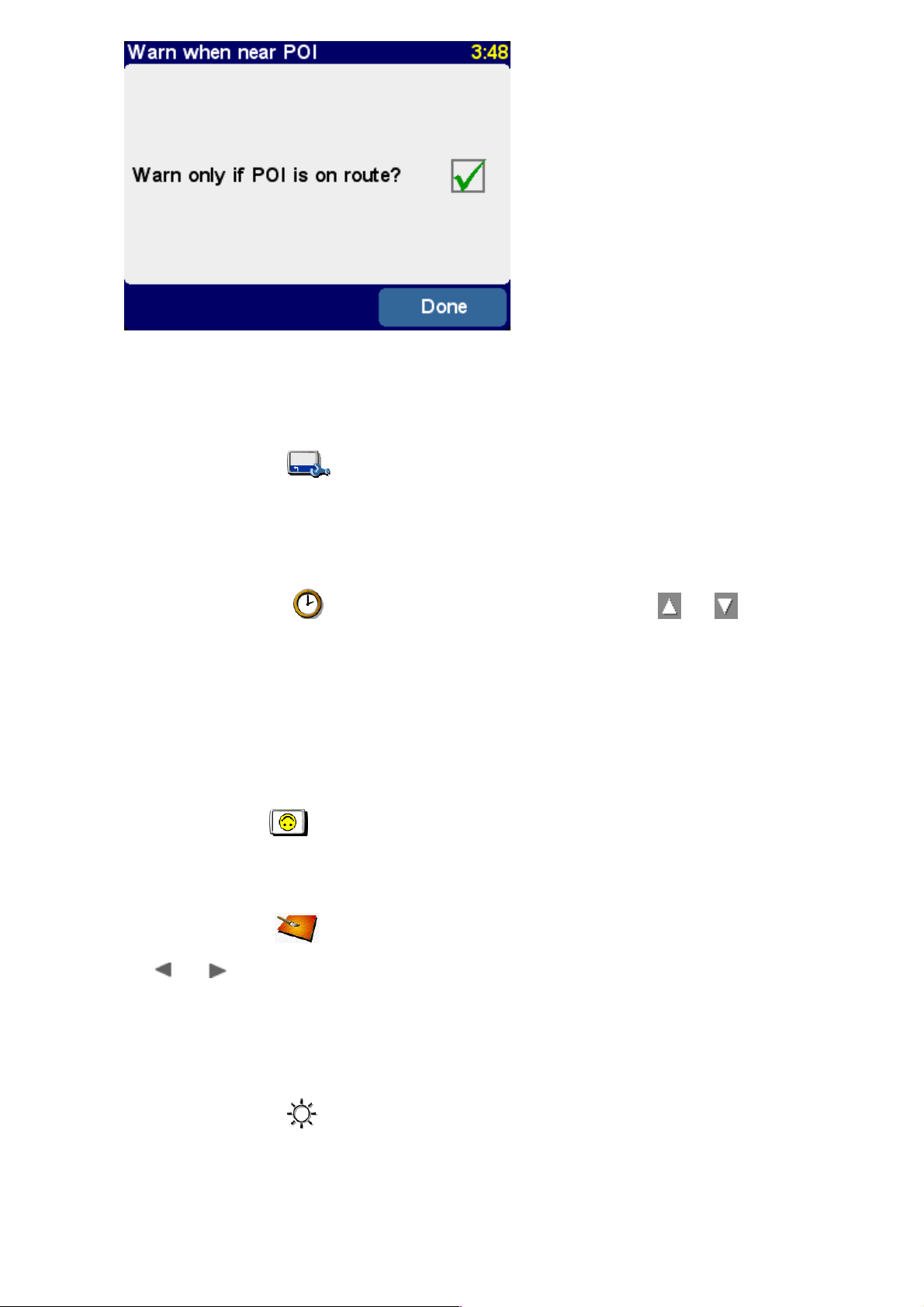
You'd typically only tick this for items that have to be on the roadside and in your direction of
travel. For example, gas stations which are on your route, rather than accessed from the
opposite direction.
Status bar preferencesStatus bar preferences
Use 'Status bar preferences' to customize the information shown at the bottom of the
navigation view. For example, you might prefer to know the arrival time rather than the remaining
time. In general, the less items you tick, the larger and clearer the layout of the status bar will be.
Set clock Set clock (TomTom GO users only)(TomTom GO users only)
You will have set TomTom GO's clock when you first started the unit up, but you can adjust it at any
time by tapping on 'Set Clock' . After choosing your preferred time format, use and
above and below each digit to adjust the hours and minutes shown. If you selected the relevant
format, tap on the 'AM' or 'PM' symbol to switch between morning and afternoon/evening hours.
Tip: If TomTom GO is outdoors, with a good view of the sky, you can tap on the 'Sync' button to set
the clock's time automatically from the GPS satellites. You might have to adjust the hours for your
correct time zone.
Rotate screenRotate screen
If the way you're positioning your TomTom system requires it, you can rotate the display with the
preference 'Rotate screen' . Each time you use this, the display will be rotated further, until
it's back to its original orientation.
Change map colorsChange map colors
Select 'Change map colors' to choose between the alternative color schemes that are
available for the maps used in your TomTom system (several of which are most suitable for use at
night). Use and to scroll through the different 'day color schemes', using 'Select' when
you're happy with the scheme shown. Repeat the process for the different 'night color schemes'.
To switch between day and night colors in normal use, see 'Use night colors'.
Change brightness Change brightness (TomTom GO users only)(TomTom GO users only)
Choose 'Change brightness' to adjust the brightness of TomTom GO's backlit screen. To
save you adjusting the brightness several times each day, there are two preference sliders, one
each for the daytime and nighttime color schemes. For example, you'll probably have the day color
brightness set quite high and the night version set quite low.
To adjust the settings, tap anywhere on the slider scales or drag a slider with your finger.
Page 30
Planning preferencesPlanning preferences
Select 'Planning preferences' to choose how routes should be calculated. If your mode of
transport is often different, you may want to select 'Ask me when I plan', otherwise select one of
the other options. 'Walking routes', 'Bicycle routes' and 'Limited speed routes' have been detailed
already, in 'Advanced planning'.
Toll charge preferencesToll charge preferences
'Toll charge preferences' give you a chance to specify what should happen in the event of
your TomTom system considering a toll road in its calculations. Select 'Always avoid toll roads' to
automatically exclude these from future routes, select 'Never avoid toll roads' to allow a best
route to be calculated regardless of any toll charges. Otherwise, simply leave this preference at its
default of 'Ask me when it happens'.
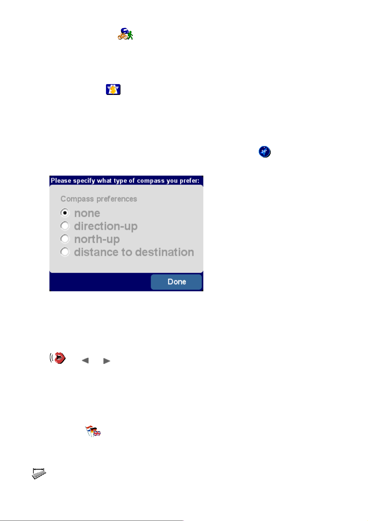
Compass preferencesCompass preferences
If you'd like a compass shown on the navigation view, use 'Compass preferences' to
choose a compass type.
'Direction-up' acts like a real compass (as if mounted on your dashboard), with the arrow
always pointing north. 'North-up' keeps the compass dial static, with the arrow indicating
your current direction of travel. 'Distance to destination' simply indicates the relative
direction and distance of your destination.
Change voiceChange voice
You can change the voice used for route instructions at any time by using the preference 'Change
voice' . Use and to scroll through the different voices and languages, choosing 'Test'
to hear a sample in each one. Use 'Select' when you're happy with the voice that's indicated.
Note: Most languages feature more than one possible voice. To change the volume of the voice
instructions, see 'Volume preferences'.
Switch languageSwitch language
You can change the language used to display all on-screen text, instructions and menu options with
'Switch language' . Just choose the one you want.
Set unitsSet units
You can change your preferred units of measurement at any time with the preference 'Set units'
. Three questions are then displayed, one a time, for distances, times and longitude/latitude.
Simply choose the formats you prefer for each unit and select 'Done' for each one.
Page 31
Operate left-handed Operate left-handed (not TomTom (not TomTom MOBILE)MOBILE)
If you are left-handed, you will probably want to use 'Operate left-handed' to place scroll
controls, the map zoom control and 'Done' and 'Cancel' buttons on the left side of the screen where
possible. You will then be able to tap on them more conveniently without your left hand obscuring
the screen. To revert to the original button placement, choose the preference 'Operate right-
handed'
Operating your TomTom system left-handed!
Keyboard preferencesKeyboard preferences
Choose 'Keyboard preferences' to choose the size (large or small) of the on-screen
keyboard for the entry of text and numbers (the smaller version leaves more room for items in
scrolling lists), and to choose between alphabetic (ABCD), typewriter (QWERTY) and French
(AZERTY) layouts.
Name preferencesName preferences
You can adjust the way road names are displayed on the maps with 'Name preferences' .
There are four check boxes shown:
Show house numbers prefixed
Tick this to display addresses with house numbers in front of their street names, e.g. '112 Oxford
street' rather than 'Oxford street 112'.
De-emphasize E-roads
Tick this to use local road numbering in preference to European road numbering, e.g. 'A10/E35' is
preferred to 'E35/A10'.
Show street names on map
Tick this to show the names of roads and side streets on the map while you are driving, provided
the current map scale is appropriate and there is room.
Show next highway
Tick this to show the name of the next highway to look for; it is displayed near the top right hand
corner of the screen.
Hide/Show tipsHide/Show tips
Hopefully you'll find the occasional tip a help (each one is only shown once, in a relevant place), but
if you really don't like them then they can be turned off altogether with 'Hide tips' or opt to
start showing them again with 'Show tips'
Disable/Enable Bluetooth Disable/Enable Bluetooth (not TomTom (not TomTom MOBILE)MOBILE)
If you plan to take your TomTom system into a hospital, plane or any other situation where radio
Page 32

communications are prohibited, you should use the preference 'Disable Bluetooth' . When
required again, simply use 'Enable Bluetooth' .
Tip: Disabling the Bluetooth transmitter in your device also helps prolong battery life if not currently
plugged into a charging source.
Show versionShow version
Use 'Show version' to find out exact version information for your TomTom system. Select
'Copyright' to read the appropriate copyright listing.
Docking preferences Docking preferences (TomTom GO users (TomTom GO users only)only)
If you have the Professional Docking Kit installed, choose 'Docking preferences' to choose
whether to link TomTom GO's night view to your vehicle's headlights and to choose whether you
want your car radio muted while route instructions are being given.
Disable/Enable ASN Disable/Enable ASN (TomTom GO 700 and 500 users (TomTom GO 700 and 500 users only)only)
TomTom GO keeps up with you, even without proper GPS reception for a short while, e.g. in
tunnels. This is accomplished by a sensor system that measures your movement, called ASN
(Assisted Satellite Navigation). If you are curious about how it works, try it out by using 'Disable
ASN' to turn it off, while having no GPS reception, and compare the results to those with
ASN turned on, as it is by default. Use 'Enable ASN' to turn ASN on again.
Connecting to Your PCConnecting to Your PC
To get the most from your TomTom system, you can link it to your PC or Mac, from where
you can back up (and restore) your Favorite locations and preferences, load new maps
and install new navigation voices.
Locate the USB data cable and plug the smaller end into the back of TomTom GO. Plug the larger
USB connector into a spare port on your Windows PC or Mac.
Note: While TomTom GO is connected to your PC (Windows will recognize it as a 'Mass storage
device'), you won't be able to use it to look up routes. Normal operation is restored as soon as you
disconnect from the PC.
Insert the TomTom GO installation CD into your PC's CD/DVD drive and the Setup program should
launch automatically.
Tip: If your PC is configured not to run CDs automatically, use 'My Computer' (or Windows Explorer) to
browse to the TomTom GO CD and then double-click on the file 'Setup'.
Page 33

Backing upBacking up
Select 'Backup/restore settings' to make a backup copy of your Home and Favorite locations,
plus your TomTom system Preferences. In the event of trouble, all of these can be restored to your
device, potentially saving you a lot of time and effort setting things up again.
Voice prompts and moreVoice prompts and more
You can add extra voice prompts by selecting 'Add/remove extra features' and then 'Add a
voice prompt', provided there is room on your memory card. Use 'Remove a voice prompt' to
delete a voice that you don't want anymore, to save space.
The option 'Install free demos, etc.' will take you online, to www.tomtom.com.
Other selectionsOther selections
The remaining selections, 'Read the manual', 'Visit www.tomtom.com' and 'Quit' are all selfexplanatory.
Connecting to your phone Connecting to your phone (GO 500 (GO 500 and GO 700 users only)and GO 700 users only)
If you have a Bluetooth-capable mobile phone then you can use your TomTom GO 700 or GO 500 as
a hands-free car kit. Although some functions are dependent on your phone's capabilities, you
should usually be able to:
Accept incoming calls on the TomTom GO screen with a single tap of the screen.
See that a new SMS message has arrived and read its contents, again with a single tap.
Dial out, using contact details retrieved from your phone's SIM card.
Get your call history, contact phone numbers and SMS messages from your phone.
Note: Visit www.tomtom.com for a list of compatible Bluetooth-enabled phones.
If this is the very first time you have used TomTom GO with your phone and there are a few steps
needed to 'pair' the two devices, i.e. make a connection.
1. Choose 'Mobile phone' to get started.
Page 34

2. Select ‘Connect to your phone’ and TomTom GO will search for your mobile phone.
3. Pick your phone from the list displayed.
4. When prompted to connect, enter a pass code (password) of ‘0000’ on the phone.
5. You will then be asked to set up a wireless Internet connection. Do this if you want to use TomTom
PLUS services.
6. Finally, you can copy your phone book to the TomTom GO. You can't use hands-free features while
this is happening.
Tip: To allow automatic connection from now on, make the TomTom GO a ‘trusted’ device on your
phone. See your phone manual for details.
Choose 'Mobile phone' to see this 'hands-free' menu. Note that the number of
unread SMS messages is shown at the bottom of every phone-related screen.
Note: The connection to your phone is also used when communicating with our Internet-based
TomTom PLUS service using GPRS.
Making a callMaking a call
Use 'Call' to bring up the Call menu:
Tap on 'Home' to call whichever number you have set as your home number, for
convenience. If this is grayed out, it just means you haven't set a number as 'home' yet.
Tap on 'Number' to make a hands-free call. Tap in the number needed using the on-screen
keypad. Use to delete a digit if you make a mistake.
Page 35

Tap on 'Phonebook entry' if you know that the number needed is already in TomTom GO's
phonebook (because it has already been retrieved from your phone or SIM card memory).
Tap on 'Point of interest' if you need to call the number associated with a local Point Of
Interest. Many built-in POIs have a phone number listed and this is a very quick way of getting in
touch with them. For example, you can call ahead to a tourist attraction to check whether it's open.
Tip: POIs with an associated phone number are shown with a green phone icon behind it.
'Recently dialed' , 'Recent caller' and 'Home' are hopefully self-explanatory.
'Redial' , on the main hands-free menu, simply redials the last number you called.
Receiving calls
If someone calls you during navigation, you'll be able to pick up the call with a single tap on the GO
screen:
Text messagingText messaging
Note: TomTom GO only handles your SMS messages. It doesn't support multimedia messaging (MMS)
or email.
Note: You are advised not to use these text messaging functions while driving. Please pull over first.
Choose 'Read/write message' to open up the main Messaging menu:
Choose 'Read inbox messages' to browse through text messages that you've already
Page 36

received. When a new message arrives at any time, you'll see an icon in the top-left corner of the
navigation view. Tapping on this will open the message, without having to use this menu option.
Tap on OPt to quickly 'Call sender', 'Reply to message' or 'Forward message'.
Choose 'Read outbox messages' to browse through messages that are waiting to be (or
have been) sent.
Choose 'Write message' to create a new message, with a similar choice of destination
numbers as when placing a call.
Note: Be careful to only write messages to mobile phone numbers. Since there is no standard
international way of identifying these from landline numbers, knowing which is which is your
responsibility!
Other phone functionsOther phone functions
In order to place calls and create text messages easily and conveniently, you should use 'Get
numbers from phone' to copy the contact numbers from your Bluetooth mobile phone into
the memory of your TomTom GO. This may take a few minutes, so please be patient.
Use 'Change home number' to enter a specific number (or pick from recent callers or
recently-dialed numbers) as your 'home'.
Common Questions and TroubleshootingCommon Questions and Troubleshooting
Here are some of the questions you may need to ask. For more questions and answers,
see www.tomtom.com
Why is the navigation view now in black and white? Why won't 'Navigate to...' work?
If the GPS receiver loses reception from the orbiting satellites, usually due to surrounding tall
buildings, the map display is switched into monochrome, to warn you that the information shown
may not be accurate at that moment. As soon as reception is regained, the display will automatically
switch back to color.
How do I charge the unit? (GO users only)
TomTom GO is normally charged whenever it's plugged into your vehicle's 12V electrical system
using the supplied DC power lead. Note that if your engine is turned off then you may need to
switch your vehicle ignition into an 'Accessories' position. Consult your vehicle handbook. If you
need to charge TomTom GO at other times, use the international AC adapter (5V), also provided.
How can I reset TomTom GO? (GO users only)
You should never have to reset TomTom GO under normal circumstances. However, in the event of
a problem you can reset the unit by removing it from the cradle and using a straightened paper clip
in the reset hole on the unit's bottom (just behind the release button).
How do I get support?
Visit www.tomtom.com for technical support and contact information. Our preferred means of
communication is by email.
Page 37

How can I find out my TomTom system's software version and serial number?
On any route summary screen, tap the software version number is shown in a box beneath the GPS
satellite status icon. If you tap the box, you'll see more details of your system's configuration and
the current map. You can also display this information by using the Preference 'Show version'
.
What do I do if I suspect the device is defective? (GO users only)
If you have already tried the reset advice above and still experience a problem, then we'd like to
hear from you. Please contact us by email using the contact addresses on www.tomtom.com
Why should I register on the TomTom web site (updates, support, etc)?
Registering your product gives you access to all the latest news about your TomTom system and will
help us to supply you with the best possible support.
How do I change the front cover? (GO users only)
You'll need a small, flat-bladed screwdriver. Starting at the bottom of the front cover, gently insert
the blade and lever the cover up and off. Work your way round the perimeter until the cover comes
away easily. Replacement covers can be obtained from TomTom.
What accessories are available? (GO users only)
1. Additional maps
2. Active antenna kit for cars with heat reflective windshields
3. Professional Docking Kit for direct connection to car power supply, lighting and audio systems
4. Additional mounting options
5. Deluxe carry bag
6. Additional front covers
What can I do if the DC power lead no longer seems to work? (GO users only)
Like all good automotive accessories, the 12V DC power lead has a fuse. Replace it with a standard
fuse from an accessory shop.
Battery notesBattery notes (GO users (GO users only)only)
We recommend that you fully charge TomTom GO the first time that you plug it in. Fully charging
the battery will take around 2 hours.
Note: TomTom GO uses a small amount of battery power to maintain its state when you switch it off. If
you don’t charge it for a prolonged period of time then you will lose this state and TomTom GO will restart. Your settings will however, be maintained. You can tell it’s time to charge TomTom GO when the
battery indicator turns orange.
SpecificationsSpecifications (GO users (GO users only)only)
TomTom GO 700TomTom GO 700
Processor: 400 MHz
Memory: 64 MB RAM
Hard disk: 2,5 GB
Screen: 3,5" 320x240x65536 colors TFT LCD
Battery: Internal Li-ion 2200 mAh
Dimensions and weight: 115 mm x 92 mm x 58 mm, 310 grams
Integrated GPS receiver: 12 channel "All-in-view" tracking with internal antenna and support for
(not in package) active external antenna
R/F Remote control
TomTom GO 500TomTom GO 500
Processor: 400 MHz
Memory: 32 MB RAM
Screen: 3,5" 320x240x65536 colors TFT LCD
Battery: Internal Li-ion 2200 mAh
Dimensions and weight: 115 mm x 92 mm x 58 mm, 310 grams
Integrated GPS receiver: 12 channel "All-in-view" tracking with internal antenna and support for
(not in package) active external antenna
Page 38

TomTom GO 300TomTom GO 300
Processor: 200 MHhz
Memory: 32 MB RAM
Screen: 3,5" 320x240x65536 colors TFT LCD
Battery: Internal Li-ion 2200 mAh
Dimensions and weight: 115 mm x 92 mm x 58 mm, 310 grams
Integrated GPS receiver: 12 channel "All-in-view" tracking with internal antenna and support for
(not in package) active external antenna
The information in this document is subject to change without notice. TomTom B.V. shall not be
liable for technical or editorial errors or omissions contained herein; not for incidental or
consequential damages resulting from the performance or use of this material. This document
contains information protected by copyright. No part of this document may be photocopied or
reproduced in any form without prior written consent from TomTom B.V.
Copyright statements
Data Source © 2005 Tele Atlas N.V. Based upon:
Topografische ondergrond Copyright © dienst voor het kadaster en de openbare registers,
Apeldoorn 2005.
© Ordnance Survey of Northern Ireland.
© IGN France.
© Swisstopo.
© BEV, GZ 1368/2003.
© Geonext/DeAgostini.
© Norwegian Mapping Authority, Public Roads Administration / © Mapsolutions. © DAV.
This product includes mapping data licensed from Ordnance Survey with the permission of the
Controller of Her Majesty!s Stationery Office. © Crown copyright and/or database right 20nn. All
rights reserved. Licence number 10002692.
© 2005 TomTom BV, The Netherlands. Patents pending. All rights reserved.
TomTom and the TomTom logo are registered trademarks of TomTom B.V. The Netherlands. All
other trademarks are the property of their respective owners.
The use of TomTom products is governed by a license agreement which is included in this package
and/or the products. This license contains a limited warranty and limitation of liability. You can
review the license conditions at www.tomtom.com.
Safety and Regulatory Information Safety and Regulatory Information (GO users only)(GO users only)
Important Safety Notices and Warnings
Global Positioning System
The Global Positioning System (GPS) is a satellite-based system that provides
location and timing information around the globe. GPS is operated and controlled
under the sole responsibility of the Government of the United States of America, who
are responsible for its availability and accuracy. Any changes in GPS availability and
accuracy, or in environmental conditions, may impact the operation of your TomTom
GO. TomTom B.V. cannot accept any liability for the availability and accuracy of GPS.
Use With Care
Use of TomTom GO for navigation still means that you need to drive with due care
and attention.
Aircraft and Hospitals
Use of devices with an antenna is prohibited on most aircraft, in many hospitals and
in many other locations. TomTom GO must not be used in these environments.
Battery
This product uses a Lithium-Ion battery. Do not use it in a humid, wet and/or
corrosive environment. Do not put, store or leave your product in or near a heat
source, in a high temperature location, in strong direct sunlight, in a microwave
Page 39

oven or in a pressurized container, and do not expose it to temperatures over 60ºC
(140ºF). Failure to follow these guidelines may cause the Lithium-Ion battery to leak
acid, become hot, explode or ignite and cause injury and/or damage. Do not pierce,
open or disassemble the battery. If the battery leaks and you come into contact with
the leaked fluids, rinse thoroughly with water and seek medical attention
immediately. For safety reasons, and to prolong the lifetime of the battery, charging
will not occur at low (below 0ºC/32ºF) or high (over 45ºC/110ºF) temperatures.
THE LITHIUM-ION BATTERY CONTAINED IN THE PRODUCT MUST BE
RECYCLED OR DISPOSED OF PROPERLY. USE TOMTOM GO ONLY WITH
THE SUPPLIED DC POWER LEAD AND AC ADAPTER FOR BATTERY
CHARGING.
To recycle your TomTom GO unit, please see your local approved TomTom service
centre.
This Document
Great care was taken in preparing this manual. Constant product development may
mean that some information is not entirely up-to-date. No liability shall be assumed
for technical or editorial errors or omissions contained herein; nor for incidental or
consequential damages resulting from the performance or use of this material. This
document contains information protected by copyright.
FCC Information to the User
Radio and Television Interference
This equipment radiates radio frequency energy and if not used properly - in strict
accordance with the instructions in this manual - may cause interference to radio
communications and television reception.
It has been tested and found to comply with the limits for a Class B digital device
pursuant to part 15 of the FCC Rules. These are designed to provide reasonable
protection against harmful interference in a residential installation. However, there is
no guarantee that interference will not occur in a particular installation. If this
equipment does cause harmful interference to radio or television reception, which
can be determined by turning the equipment off and on, the user is encouraged to
try to correct the interference by one or more of the following measures:
Reorient or relocate the receiving antenna.
Increase the separation distance between the equipment and the receiver.
If you are using the equipment with a mains adapter, plug it into an outlet which is
on a different circuit from that to which the receiver is connected.
Consult an experienced radio/TV technician for help.
Important
This equipment was tested for FCC compliance under conditions that included the
use of shielded cables and connectors between it and the peripherals. It is important
that you use shielded cable and connectors to reduce the possibility of causing radio
and television interference. Shielded cables, suitable for the product range, can be
obtained from an authorized dealer.
If the user modifies the equipment or its peripherals in any way, and these
modifications are not approved by TomTom, the FCC may withdraw the user's right
to operate the equipment.
For customers in the USA, the following booklet prepared by the Federal
Communications Commission may be of help: "How to Identify and Resolve Radio-TV
Interference Problems". This booklet is available from the US Government Printing
Office, Washington, DC 20402
Stock No 004-000-00345-4.
FCC Declaration of Conformity
Tested to Comply with FCC Standards for Home or Office Use.
TomTom GO has been tested to – and complies with – part 15 of the FCC rules.
Page 40

Operation is subject to the following two conditions:
1. This device may not cause harmful interference.
2. This device must accept any interference received, including interference that may
cause undesired operation.
Responsible party:
TomTom, Inc.
150 Baker Ave
Concord, MA 01742
Tel: 978 287 9555 option 1
Fax: 978 287 9522
Toll Free: 866 4 TOMTOM (866 4 866 866)
(The Toll Free number does not work outside of the US)
Emissions information for Canada
This Class B digital apparatus complies with Canadian ICES-003.
Cet appareil numérique de la classe B est conforme à la norme NMB-003 du Canada.
CE Marking
This product fully satisfies the requirements for CE marking when used in a
residential, commercial or light industrial environment.
[DL2] R&TTE Directive
This equipment complies with the essential requirements of EU Directive 99/5/EC
(declaration available at www.tomtom.com).
Do not use this product onboard aircraft, or in hospitals, without first obtaining
permission.
 Loading...