


Distributed by
Any reference to Raytheon or
RTN in this manual should be
interpreted as Raymarine.
The names Raytheon and RTN
are owned by the
Raytheon Company.
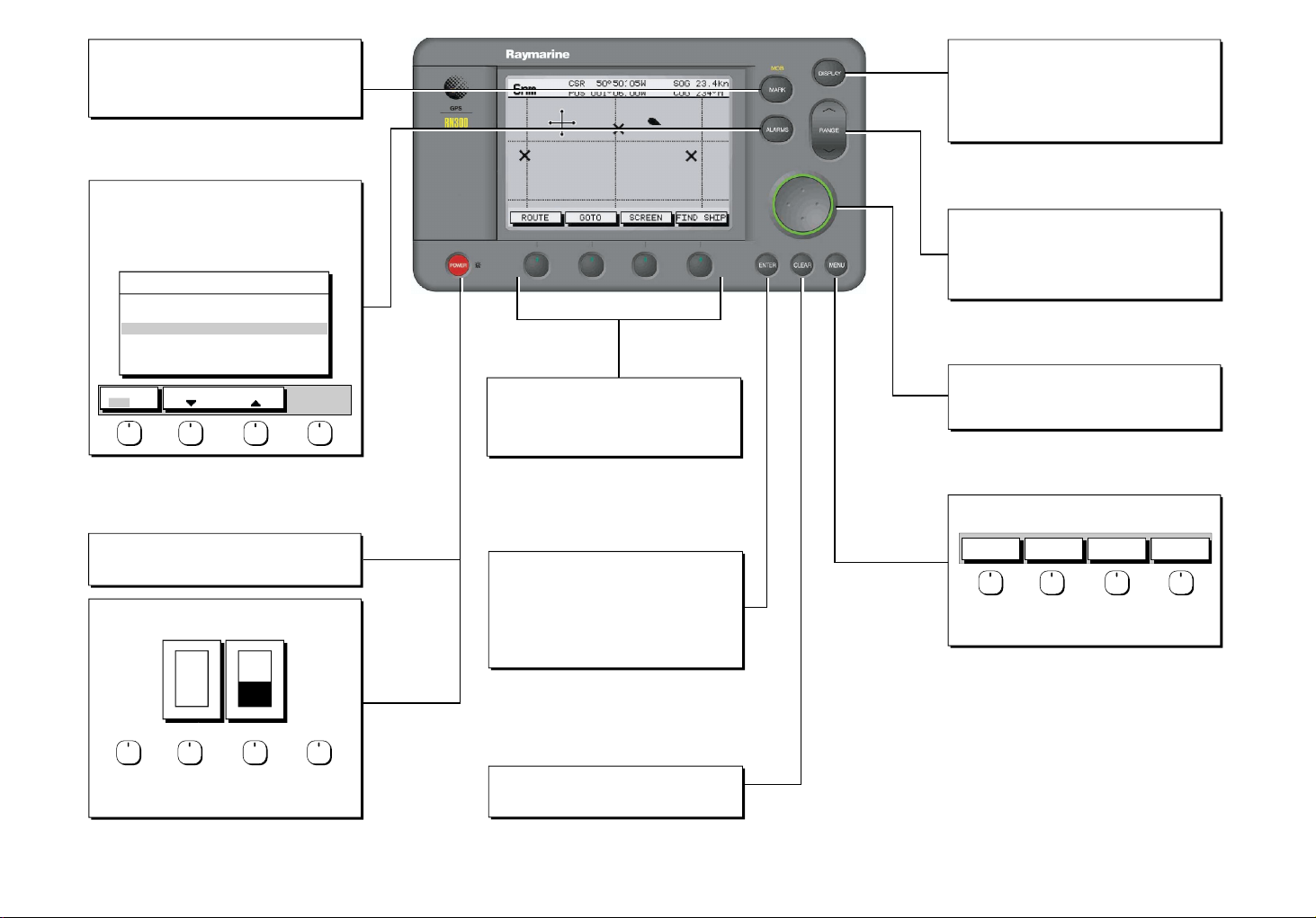
MARKS/MOB
Controls placing waypoints and Man Overboard function.
- Press to access Waypoint soft keys; use soft keys to Place
Waypoint at cursor or vessel position. Press ENTER to finish.
- Press and hold for 2 seconds to activate or cancel MOB.
ALARMS
Use to set up alarm parameters.
- Press for display alarm list.
- Use Trackpad to select alarm.
- Use up down soft keys to set alarm limits.
- Press ENTER to finish
ALARMS SET UP
ARRIVAL ALARM
OFF TRACK ALARM
ANCHOR ALARM
COUNTDOWN TIMER
ALARM CLOCK
ALARM
OFF ON
SELECT DISTANCE
0.01nm
ON
OFF
00:10:00
OFF
POWER
Press and hold to switch on display.
Press for 3 seconds to turn off display.
POWER
Press momentarily to access lighting and contrast.
OFF
O
F
F
LIGHT CONTRAST
50%
Soft keys
Press to select option, or to highlight option or slider.
Labels change when you press soft/dedicated key.
Elipses (...) after the text indicate that pressing soft key
leads to a further display of soft key options.
ENTER
Confirms selection and (if appropriate) clears current
soft key labels. It either performs the selected task,
accepts changes, or leads to display of more options.
When cursor text is displayed, cursor takes control
of the object.
When arrow-head cursor symbol is displayed, the
object under cursor control is dropped.
DISPLAY
Controls display mode pages.
- Press repeatedly to toggle through display modes.
- Press and hold for 2 seconds for default display.
See over for display modes.
Note: Where multiple pages are available, use associated
soft keys to display.
RANGE
Controls range scale.
Range scale is shown in the Status Bar.
- Press top of key to increase the range scale.
- Press bottom of key to decrease the range scale.
- Press and hold to change the scale rapidly.
TRACKPAD
Controls cursor position on the screen, and also the sliders,
setup options and text entry.
Hold the trackpad down to move the cursor rapidly.
MENU
Provides access to setup options.
SYSTEM
SET UP¬
Press soft key to display required setup menu, then use
trackpad to select option and soft key to change setting.
Press ENTER to close menu and CLEAR to finish.
PLOTTER
SET UP¬
TRACK
SET UP¬
GPS
SET UP¬
D5832-1
Select a slider using the soft key or trackpad left/right.
Adjust slider using trackpad up/down.
Press ENTER to finish.
CLEAR
Cancels operation in progress and returns to the
previous display.
Bridge Card Raynav 300 GPS Plotter
86053_4

Waypoint List
Press MARK then WAYPOINT LIST. Use trackpad to select, then... Press ROUTE then MORE...
Press EDIT WAYPOINT to change its SYMBOL, NAME, POSITION;
ERASE WPT to remove the Waypoint from the list or
GOTO WAYPOINT to navigate towards the selected Waypoint.
Press MAKE NEW WAYPOINT to place a new Waypoint at vessel's
current position and edit it immediately.
Press WAYPOINT TRANSFER to Send or Receive Waypoints via NMEA.
WAYPOINT LIST
SYMBOL NAME
POSITION
BRG 348°m
TEMP 20°C
DATE 23/11/00
GOTO
WAYPOINT
WAYPOINT
EDIT
WAYPOINT 001
WAYPOINT 002
WAYPOINT 003
WAYPOINT 004
50°50^000N
001°06^000W
RNG 1.00nm
DEPTH 12.3m
TIME 08:45
MAKE NEW
WAYPOINT
WAYPOINT
TRANSFER
GOTO Waypoint
Press GOTO...
...then GOTO WAYPOINT.
The Waypoint List is displayed (see above). Use the trackpad to
select a Waypoint. Press GOTO WAYPOINT.
Navigation starts towards the selected Waypoint.
Stop GOTO
Press GOTO...
...then STOP GOTO.
The dotted line from the vessel to the target is removed.
GOTO
WAYPOINT
STOP
GOTO
CURSOR
GOTOROUTE SCREEN FIND SHIP
GOTO
FOLLOW
ROUTE
GOTOROUTE SCREEN FIND SHIP
Make New Waypoint at LAT/LON/BRG/RNG
Press MARK...
PLACE WPT
PLACE WPT
AT VESSEL
EDIT
WAYPOINT
WAYPOINT
LIST
MAKE NEW
WAYPOINT
WAYPOINT
TRANSFER
AT CURSOR
Press WAYPOINT LIST to display the Waypoint List (see above).
GOTO
WAYPOINT
Press MAKE NEW WAYPOINT to create a new Waypoint (at the
vessel's position). The new Waypoint is added to the bottom of the list.
Press EDIT WAYPOINT then POSITION to display WPT POSITION box.
Use soft keys to select LAT, LON, BRG or RNG for editing.
Use trackpad left/right to select character, then trackpad up/down to
change the character. Press ENTER when complete.
Route List
Press ROUTE LIST to display the Route List on screen.
Use the trackpad to select the required Route.
Press SHOW ROUTE to display the Route on screen.
Press ERASE ROUTE to delete the Route or...
Press ROUTE INFO to display the selected Route's details.
Press NAME ROUTE to name the Route or...
TRACKPAD TO SELECT ROUTE,SOFTKEYS
TO SELECT ACTION, "CLEAR" TO CLOSE MENU
ROUTE LIST
CURRENT
1 ALDERNEY-SOLENT
2 COWES-PORTSMOUTH
3 BRAYE-CHERBOURG
4 HOMES TO COWES
5 NO NAME
SHOW
ROUTE
ERASE
ROUTE
Create New Route
Press ROUTE...
MAKE
ROUTE
PLACE
PLACE
WAYPOINT
WAYPOINT
WAYPOINT
WAYPOINTS
COWES
GURNARD LEDGE
MAIN CHANNEL
NEEDLES FAIRWAY
PORT SOLENT
50°50^000N
001°06^000W
348°
m
2.30
INSERT
REMOVE
WAYPOINT
WAYPOINT
GOTOROUTE SCREEN FIND SHIP
CLEAR
EDIT
ROUTE
ROUTE
ACCEPT
UNDO
ROUTE
01 HARBOUR
02 MAIN CHANNEL
03 COWES
04 LYMINGTON
50°52^230N
001°02^390W
nm
300°
ACCEPT
ROUTE
...then MAKE ROUTE
...then USE WPT LIST...
...the Route Building Table is displayed.
Use trackpad left/right to switch between the columns.
Select a Waypoint from WAYPOINTS column, switch to ROUTES column
and use trackpad up/down to select a position in the list.
Press INSERT WAYPOINT to place Waypoint below selected position.
Continue selecting and placing Waypoints until the Route is complete.
To remove a Waypoint from the ROUTES column, use the trackpad to
highlight the Waypoint then press REMOVE WAYPOINT.
Press ACCEPT ROUTE or ENTER to complete the Route.
To cancel the operation, press CLEAR twice to return to the main
Plotter screen.
To save the Route, press ROUTE, then MORE, then SAVE ROUTE.
Press YES to name the Route or NO to save as "ROUTE NOT NAMED".
ROUTES
m
MORE!
USE WPT
LIST
1.00
USE
CURSOR
ROUTE
INFO
nm
NAME
ROUTE
Display Options
... after preliminary displays, the default display is shown
Waypoint data
SD-FIX
GPS data
SD-FIX
Press
DISPLAY
to return to
GPS/Waypoint
Data
CSR 50°50^05W SOG 23.4kn
6nm
POS 001°06^00W COG 234°M
GOTOROUTE SCREEN FIND SHIP
DISPLAY
Press to show
Plotter Display
TIME POSITION CMG DMG
09:00 50°50^000N 239°m 4.8nm
20/12 001°06^000W
09:30 50°51^000N 241°m 5.2nm
20/12 001°07^000W
10:00 50°52^000N 240°m 4.5nm
20/12 001°08^000W
ROUTE
GOTO
50°50^000W
001°06^000W
ROUTE GOTO GPS DATA WPT DATA
STOP LOG
CLEAR LOG
Press
DISPLAY
to show
Data Log
Press
POWER
SD-FIX
SD-FIX
SD-FIX
SD-FIX
SD-FIX
WPT 004
124°
am
50°50^000N
001°06^000W
GOTOROUTE
0.55
GPS DATA WPT DATA
12.0
17
kts
STEER STARBOARD
STEER STARBOARD
WPT 004
Note: In any display mode
press DISPLAY key for 2 seconds
to return to default display.
WPT RNG WPT BRG PILOT
28.7
nm
TIME SPEED COG
10:40:18
DEPTH POSITION
36.5
ft
OWN POS
XTE
XTE
XTE
320°M
WPT BRG
WPT RNG
WPT BRG
WPT BRG
0.55nm
352°
M
COG
WPT RNG
050°
050°M
SOG
nm
SOG
COG
SOG
WPT DATA
12.0kts
SOG
WPT DATA
M
SOG
SOG
WPT DATA
WPT DATA
kts
WPT DATA
Environment data
SD-FIX
Boat data
SD-FIX
DEPTH 12.5
SOG
APPARENT WIND
TRUE WIND
SD-FIX
DEPTH 12.5M
SPEED 11kts
SPEED 11kts
STEER STARBOARD
ROUTE GOTO BOAT DATA ENVIROMNT
4040
nm nm
STEER STARBOARD
ROUTE
MANUAL
T
124°
T
SOG
15.1
kts
Press
DISPLAY
to show
Boat/Environment
Data
m
STEER STARBOARD
WPT 004
WPT 004
355°T
30 30
STEER STARBOARD
WPT 004
GOTO CDI
Data Boxes
GPS DATA WPT DATA
DISPLAY
Press to show
CDI or BDI
225°T
20 20
10
10
WPT 004
Press
DISPLAY
to show
WPT BRG
WPT BRG
320°
WPT RNG
0.55
COG
050°
SOG
12.0
WPT DATA
XTE
0.05
WPT BRG
300°
WPT RNG
23.2
TTG
BDI BDI
04
h
:12
BDI
WIND
WPT BRG
WPT RNG
M
COG
050°M
nm
SOG
SOG
M
SOG
WPT DATA
kts
WPT DATA
0.05nm
WPT BRG
nm
300°T
WPT RNG
T
23.2nm
nm
04
m
WIND
SOG
XTE
TTG
h 12m
D5833-2
 Loading...