

Rand McNally Foris 850 User Manual
User Manual

Legal information
Rand McNally
9855 Woods Drive
Skokie, IL 60077
Rand McNally follows a continuous review process and reserves the right to provide changes
and enhancements that may not be reflected in the pictures and specifications in this
document.
All trademarks mentioned in this manual belong exclusively to the respective owners and
may therefore not be used for commercial or other purposes.
© 2013 RM Acquisition, LLC, d/b/a Rand McNally.
All rights reserved.

Contents
Safety instructions .................................................................................................................... 4
FCC compliance statement ...................................................................................................... 4
Device description .................................................................................................................... 5
Device ............................................................................................................................. 5
Opening and closing the housing cover .......................................................................... 6
Inserting the batteries ..................................................................................................... 6
Inserting a micro SD card................................................................................................ 6
Bike mount ...................................................................................................................... 7
1. Navigation view ............................................................................................................... 9
2. Main menu .................................................................................................................... 11
3. Destination entry ........................................................................................................... 11
3.1 Address ................................................................................................................... 11
3.2 Home ...................................................................................................................... 11
3.3 Points of interest ..................................................................................................... 12
3.4 Previous destinations .............................................................................................. 13
3.5 Position on map ...................................................................................................... 13
3.6 Waypoints ............................................................................................................... 13
3.7 Coordinates ............................................................................................................. 13
3.8 Geocaches ............................................................................................................. 14
3.9 Tracks ..................................................................................................................... 14
3.10 Trips ........................................................................................................................ 14
3.11 Arrange menu ......................................................................................................... 14
3.12 Calculated route ...................................................................................................... 14
4. Trip computer ................................................................................................................ 15
5. Trip Manager ................................................................................................................. 15
5.1 Create trip ................................................................................................................ 15
5.2 Loop Me! .................................................................................................................. 16
5.3 Select saved trip ...................................................................................................... 16
6. Settings ......................................................................................................................... 17
6.1 Navigation settings ................................................................................................... 17
6.1.1 Route options .................................................................................................... 17
6.1.2 Set routing ........................................................................................................ 17
6.1.3 Speed profile ..................................................................................................... 18
6.1.4 Ask about route options .................................................................................... 18
6.2 Map display .............................................................................................................. 18
6.2.1 Map perspective ............................................................................................... 18

6.2.2 Map oriented ..................................................................................................... 18
6.2.3 Position on street .............................................................................................. 18
6.2.4 City names on map ........................................................................................ 18
6.2.5 Auto zoom ......................................................................................................... 18
6.2.6 Points of interest on map .................................................................................. 18
6.2.7 Track recording ................................................................................................. 18
6.2.8 Arrange menu .................................................................................................. 18
6.3 System / General ..................................................................................................... 19
6.3.1 Battery type ....................................................................................................... 19
6.3.2 GPS Info ........................................................................................................... 19
6.3.3 Brightness ......................................................................................................... 19
6.3.4 Volume .............................................................................................................. 19
6.3.5 Calibrate compass ............................................................................................ 19
6.3.6 Calibrate barometer .......................................................................................... 19
Set position format ............................................................................................ 20
6.3.7
Screen auto-off ................................................................................................. 20
6.3.8
6.3.9 Set home .......................................................................................................... 20
6.3.10 Quick access menu ....................................................................................... 20
6.3.11 Quick access button assignment .................................................................. 20
6.3.12 Miles / kilometers .......................................................................................... 20
6.3.13 Delete history ................................................................................................ 20
6.3.14 Default settings ............................................................................................. 20
6.3.15 Time .............................................................................................................. 20
6.3.16 Voice ............................................................................................................. 20
6.3.17 Screen ........................................................................................................... 20
6.3.18 Info ................................................................................................................ 21
6.3.19 Arrange menu ............................................................................................... 21
7. Active route ................................................................................................................... 21
8. Remember position ....................................................................................................... 21
9. Geocaching ................................................................................................................... 21
9.1 Transfer files to your device ..................................................................................... 21
9.2 Search for geocaches .............................................................................................. 22
9.2.1 Cache list .......................................................................................................... 22
9.2.2 Filter .................................................................................................................. 22
9.2.3 Detailed view .................................................................................................... 22
9.2.4 Options ............................................................................................................. 23
9.2.5 Arrival at the geocache ..................................................................................... 23
9.2.6 Delete geocache ............................................................................................... 23

9.2.7 Logging ............................................................................................................ 23
9.3 Pocket query ............................................................................................................ 24
9.4 Found geocaches .................................................................................................... 24
9.5 Geocache icons ....................................................................................................... 24
10. Waypoint manager ........................................................................................................ 25
10.1 Choose waypoint .................................................................................................. 25
10.2 Create waypoint ................................................................................................... 25
10.3 Delete created waypoints ..................................................................................... 25
11. Track manager .............................................................................................................. 25
11.1 Record track ......................................................................................................... 25
11.2 Detailed view of a track ........................................................................................ 26
11.3 Modify track .......................................................................................................... 26
11.4 Start track ............................................................................................................. 26
11.4.1 TrackNav ....................................................................................................... 26
11.4.2 Start track directly ......................................................................................... 26
12. Extras ............................................................................................................................ 27
12.3 GPX manager ....................................................................................................... 27
12.4 Map errors ............................................................................................................ 27
12.4.1 Create map error ........................................................................................... 27
12.4.2 Create POI error ............................................................................................ 27
12.4.3 Edit map and POI errors ............................................................................... 27
12.5 Help ...................................................................................................................... 28
13. Arrange menu ............................................................................................................... 28
14. Trailhead ....................................................................................................................... 28
14.1 Introduction to Trailhead ...................................................................................... 28
14.2 Import of GPX files ............................................................................................... 28
14.3 Transfer of content ............................................................................................... 30
14.4 Import of POIs ...................................................................................................... 30
14.5 Software ............................................................................................................... 32
15. Tips and tricks ............................................................................................................... 32
16. Troubleshooting ............................................................................................................ 33
17. Technical data ............................................................................................................... 34
18. Service & support .......................................................................................................... 34
19. Glossary ........................................................................................................................ 34
20. License terms and conditions ....................................................................................... 36

Safety instructions
For optimal results, do not store or operate the device in extreme temperatures below 15°F
or above 140°F. Avoid exposing the device to sudden fluctuations in temperature, which
could cause condensation to collect. If condensation forms, wait it has dried before operating
the device.
The device is waterproof in accordance with the IPX7 standard and is protected against
being temporarily submerged. CAUTION: To protect the device against the ingress of water,
make sure the battery housing and USB cover are completely closed. Note that the device
must not be submerged for longer than 30 minutes in a water depth of 3 feet.
Do not place, store or leave the device in or next to heat sources, at places which have high
temperatures, or a high level of solar radiation, in a microwave oven or pressurized
container. Use only Rand McNally original accessories or Rand McNally-approved adapters.
The use of other components may result in malfunctions and/or serious damage.
Make sure you observe the following safety instructions in order to prevent accidents or
serious injuries:
This navigation device for outdoor use is merely an orientation and navigation aid
that cannot be a substitute for making a sensible assessment of the situation you are
in. Please note the particular characteristics of the terrain and the routes you are
using. Do not follow any routes or suggested routes which would entail a dangerous
or illegal form of hiking or riding or would place you in a dangerous situation.
Road traffic regulations must be complied with at all times, for example when cycling,
and have priority over the routes of the navigation device.
Never operate the navigation device while riding and do not allow yourself to be
distracted by the device while riding.
The map data which is used may include inaccurate or incomplete data. You should
therefore check the calculated route to see if it makes sense and choose your own
alternative route if necessary.
CAUTION: The navigation device is intended for hiking, biking, and other outdoor
recreational uses and, as such, is not suitable for use as a vehicle navigation system.
FCC Compliance Statement
This device complies with part 15 of the FCC rules. Operation is subject to the following two
conditions: (1) this device may not cause harmful interference, and (2) this device must
accept any interference received, including interference that may cause undesired operation.
This equipment has been tested and found to comply with the limits for a Class B digital
device, pursuant to part 15 of the FCC rules. These limits are designed to provide
reasonable protection against harmful interference in a residential installation. This
equipment generates, uses, and can radiate radio frequency energy and may cause harmful
interference to radio communications if not installed and used in accordance with the
instructions. However, there is no guarantee that interference will not occur in a particular
installation. If this equipment does cause harmful interference to radio or television
reception, which can be determined by turning the equipment off and on, the user is
encouraged to try to correct the interference by one of the following measures:
Reorient or relocate the receiving antenna.
Increase the separation between the equipment and the receiver.
Connect the equipment into an outlet that is on a different circuit from the GPS unit.
Consult the dealer or an experienced radio/TV technician for help.
Rand McNally ForisTM User Manual
4
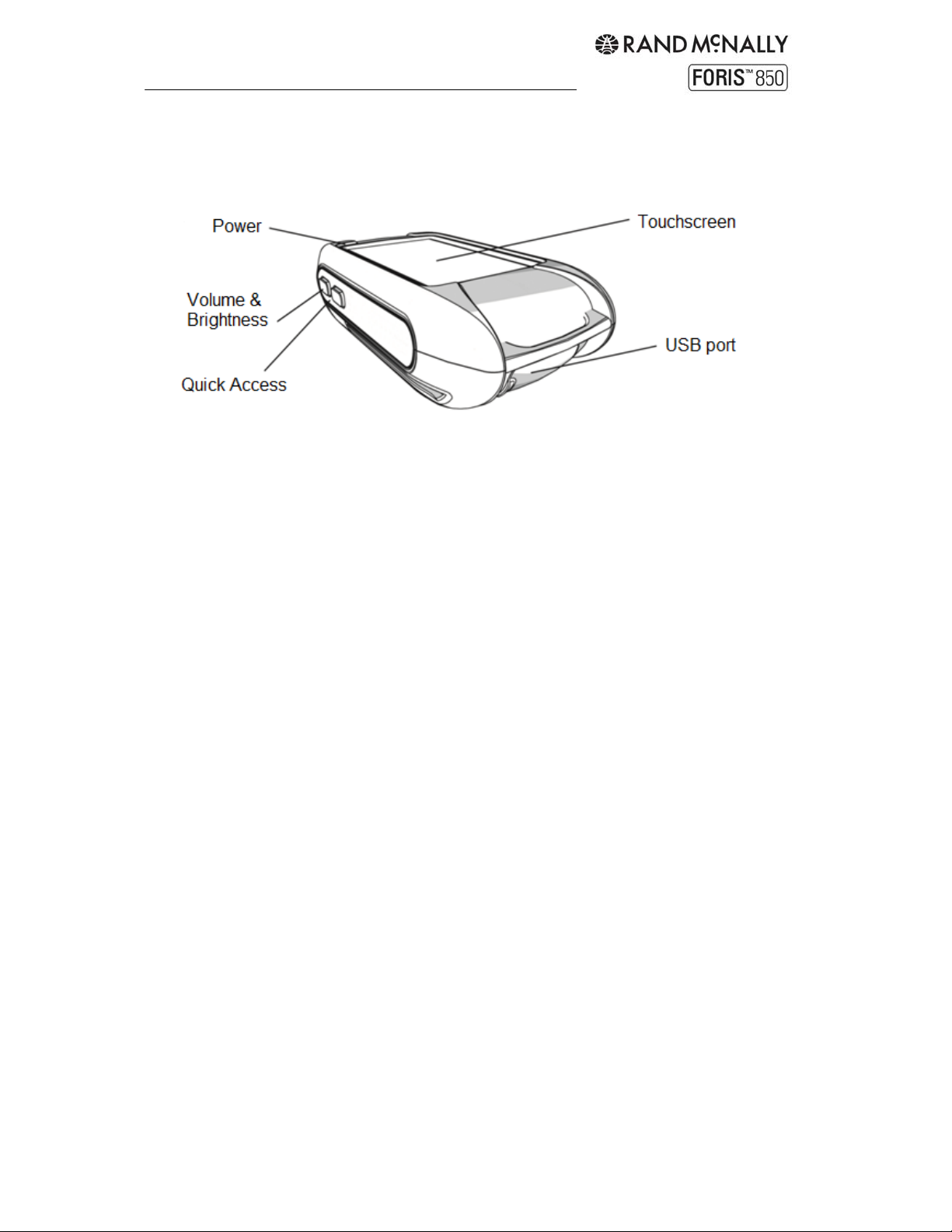
Device description
Device
Power: Hold to turn the device on/off. Quick press to access the following options:
Touchscreen lock: Freezes at the current screen. To deactivate, quick press the
power button and tap "Touchscreen lock" again.
Screen off: Switches the screen off. Ongoing navigations or track recordings remain
active. Tap the screen to return. Use this setting to save power.
Stand-by: Switches to stand-by mode. Quick press the power button to return.
Switch off: Switches the device off completely.
Cancel takes you back to the application.
Volume & Brightness: Adjust volume and brightness.
Quick Access: In the default setting, this button starts or pauses the track recording. To
change the function of this button, see "Settings > System / General > Quick Access Button."
Note: If the device is not responding, press the power button for approximately 3 seconds to
restart. Or simply remove and reinstall the batteries.
Touchscreen: Displays the map and the menu.
USB port: Connects the device to a PC via the USB cable. The port is located beneath a
rubberized cover to protect it from water. This cover should be completely closed when using
the device.
Speaker: The speaker is located on the back of the device.
Rand McNally ForisTM User Manual
5
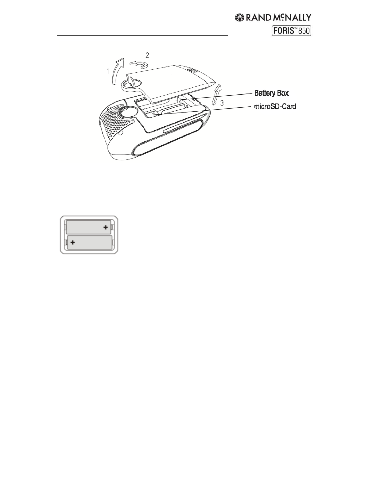
Battery cover
To open the battery cover, lift the silver fastener, turn it 90° counterclockwise and pull it up
so that the cover of the battery compartment is removed. Insert the batteries as indicated in
the battery compartment.
Place the battery cover back on and close it by turning the silver fastener clockwise. Make
sure that the housing cover fits correctly and locks flush in place.
Batteries
The device works with AA alkaline (included), lithium or rechargeable NiMH batteries. Please
note that batteries cannot be recharged while in the device.
Note: To maximize battery life, select the correct battery type under "Settings >
System/General > Battery type".
Additional tips for maximizing battery life
Reduce the brightness of the display. (Display dims automatically when batteries are
low.)
Reduce the volume. (Volume decreases automatically when batteries are low.)
Set navigation to beep output in "Settings > Navigation Settings > Set guidance
preference."
Set to "screen off" while in use. (See page 5.)
Keep the device out of the cold. Batteries are very sensitive to temperature. In cold
conditions, the run time of the batteries is greatly curtailed. Optimum results are
achieved at around 70°F.
When using rechargeable batteries, follow the manufacturer‘s instructions for
maximum run time.
Rand McNally ForisTM User Manual
6
Do not use any sharp objects to remove the batteries. Do not attempt to open the batteries.
Note the regulations governing the disposal of the batteries.
Inserting a micro SD card (optional)
First open the housing cover. Remove the batteries if necessary. Then slide the metallic
retaining plate for the micro-SD card upwards and flip it up from underneath. Insert the
micro-SD card.
Retaining Plate
Make sure the contacts on the card are pointing downwards. Flip the retaining plate back
down towards the device and lock it in place by sliding it downwards.
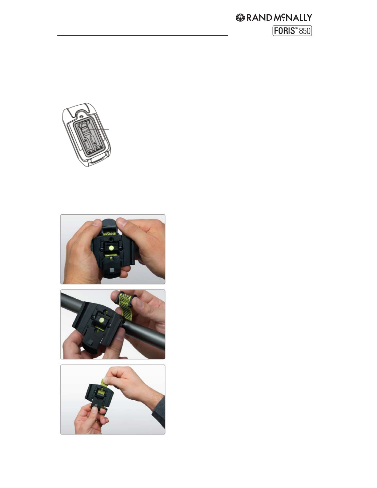
Bike Mount
1. Push up on the lever at the top of the mount
to release the lock.
2. Wrap the strap around the handlebar and
reinsert the locking lever.
3. Adjust to fit as necessary by releasing the
tab in the middle of the bracket and pulling the
strap.
Rand McNally ForisTM User Manual
7
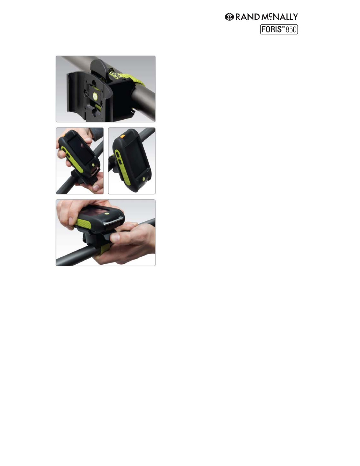
4. Once in place, the mount holds securely to
the handlebar. (Note: To mount to the stem, remove
the screws, rotate the bracket 90 degrees, and
replace the screws.)
5. Slide the device onto the bracket until it clicks
into place.
6. To remove the device, press down on the tab
at the bottom of the bracket and slide off.
Rand McNally ForisTM User Manual
8
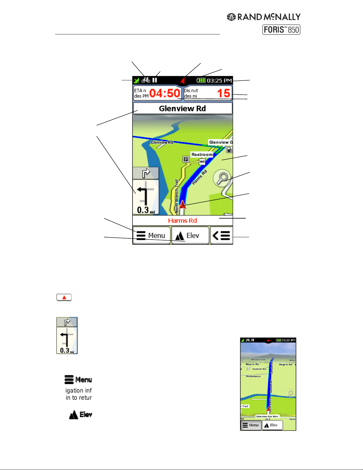
1. Navigation view
Means of transport
GPS signal
Track recording
Compass
Next maneuver(s)
Main menu
Elevation profile
Info Boxes: Show information about the calculated route. Tap on the box to select which
information to display. (Note: If no value displays for "north bearing," calibrate the compass
(see Chapter 6.3.5).)
Map: Shows the current position. Touch the screen to drag the map to another location. The
Here button, which appears at the bottom, returns the map to the current position.
Next Maneuver:
The arrow indicates the direction of the next turn. Tap to repeat. Also displays
other intersecting roads and the distance to your next maneuver. The top field
displays the second maneuver. Upcoming intersections
may also display and count down here.
Battery
Current time
Info boxes
Map
Zoom
Current position
Current
street/coordinate
Quick access menu
Goes to the main menu. Hold to hide the
navigation information and show a "cleaner" view of the map. Tap
again to return to the main menu.
Displays and hides the elevation profile on the
map. Tap the profile itself for a more detailed view.
Rand McNally ForisTM User Manual
9
Quick Access Menu: Offers faster access to three functions of your choice. Hold
to set preferences. (See Chapter 6.3.10.) Default functions:
Starts the track recording. Tap to pause the recording; hold to stop recording.
Read more about track recording in Chapter 11. (Note: It is recommended, before you start
the track recording, that you calibrate the barometer manually (see Chapter 6.3.6).)
Saves the current position (see Chapter 8).
Shows a large-scale view of the compass. Tap to calibrate.
Current Street / Coordinates: Current street location, or coordinates for off-road terrain.
Current Position: Marked by the red arrow.
Zoom Button: Tap on the zoom button and then on the plus or minus symbol to adjust
the scale of the map. Tap the bird’s eye view to zoom out and see the entire route.
GPS Signal: Indicates the status of the GPS reception.
Weak: GPS signal is not sufficiently strong to allow positioning. Signals are being
received from fewer than 3 satellites.
Adequate: GPS signal is sufficiently strong to allow positioning. Signals are being
received from 3 satellites.
Strong: A high-quality GPS signal is being received that allows your elevation to be
determined. Signals are being received from at least 4 satellites.
Means of Transport: The symbols and correspond to biking and hiking mode.
Compass: Indicates the current compass direction. Red indicates the compass needs to be
recalibrated. See "Settings > System / General > Calibrate compass".
Battery: Indicates battery power.
At least 70% capacity remaining
15% – 70% capacity remaining
Less than 15% capacity remaining
Device connected to power source
Tip: Wherever you are in the menu, you can easily switch back to the map view at any time
by holding down Cancel or Back.
Tap on the map
Tap on a point on the map to mark the point with a pin and display the address or position.
Tap on "Actions" to route to the location, save it as a waypoint, or search nearby.
POIs on the map
Tap on any point of interest to view more information. Tap the title to show Info, Map and
Options tabs, or tap "Actions" to route to the location, save it as a waypoint, or search
nearby.
Rand McNally ForisTM User Manual
10
 Loading...