


2008 Nissan Navigation System Owner's Manual
If your vehicle's VIN is XXXXXXXXXXX633673 or higher:
Select 2008 Voice Recognition Owner's Manual Supplement in the bookmarks panel on the left side
of the screen.
(Click here to view this publication.)
In addition to the Navigation System Owner's Manual, a Voice Recognition system supplement publication
may pertain to your vehicle. Compare the VIN (vehicle identification number) information found on your
vehicle's VIN plate to the VIN information below to determine applicability. The VIN plate is located on top
of the instrument panel, on the driver's side of your vehicle.

Table of
Introduction
1
Contents
Getting started
Map settings
Setting a destination
Route guidance
Storing a location/route
Viewing technical information
Other settings
Voice recognition
General system information
Troubleshooting guide
Index
2
3
4
5
6
7
8
9
10
11
12

1 Introduction
How to use this manual ....................................... 1-2
For safe operation .............................................. 1-2
Reference symbols ......................................... 1-2
Safety information .............................................. 1-3
Laser product.................................................... 1-4
HOW TO USE THIS MAN UAL FOR SAFE OPERATION
This manual uses special words, symbols and
icons, organized by function.
Please refer to the following items and familiarize
yourself with them.
WARNING
This is used to indicate the presence
of a hazard that could cause death or
serious personal injury. To avoid or
reduce the risk, the procedures must
be followed precisely.
CAUTION
This is used to indicate the presence
of a hazard that could cause minor or
moderate personal injury or damage
to your vehicle. To avoid or reduce the
risk, the procedures must be followed
carefully.
NOTE:
This indicates an item to help you understand and maximize the performance of
your vehicle. If ignored, it may lead to a
malfunction or poor performance.
REFERENCE SYMBOLS
INFO:
This indicates information that is necessary for
efficient use of your vehicle or accessories.
Reference page:
This indicates the title and page that you should
refer to.
<>:
This indicates a button on the control panel.
[]:
This indicates a key/item displayed on the
screen.
Voice Command:
This indicates an operation by voice command.
1-2 Introduction

SAFETY INFORMATION
This system is primarily designed to help you
reach your destination, and it also performs
other functions as outlined in this manual.
However, you, the driver, must use the system
safely and properly. Information concerning road
conditions, traffic signs and the availability of
services may not always be up-to-date. The
system is not a substitute for safe, proper and
legal driving.
Before using the navigation system, please read
the following safety information. Always use the
system as outlined in this manual.
WARNING
. When the driver wants to operate
the navigation system or use the
multi-function controller, first park
the vehicle in a safe location and
set the parking brake. Operating
the system while driving can distract the driver and may result in a
serious accident.
. Do not rely on route guidance
alone. Always be sure that all
driving maneuvers are legal and
safe in order to avoid accidents.
. Do not disassemble or modify this
system. If you do, it may result in
accidents, fire or electrical shock.
. If you notice any foreign objects in
the system hardware, spill liquid on
the system or notice smoke or a
smell coming from it, stop using the
system immediately and contact a
NISSAN dealer. Ignoring such conditions may lead to accidents, fire
or electrical shock.
CAUTION
. Do not use this system if you notice
any malfunctions such as a frozen
screen or the lack of sound. Continued use of the system may result
in accidents, fire or electrical shock.
. Some states/provinces may have
laws limiting the use of video
screens while driving. Use this
system only where it is legal to do
so.
. Extreme temperature conditions
[below −48F(−208C) and above
1588F (708C)] could affect the performance of the system.
NOTE:
Do not keep the navigation system running
with the engine stopped. Doing so may
discharge the vehicle battery. When you
use the navigation system, always keep
the engine running.
Introduction 1-3

LASER PRODUCT
This navigation system is certified as a Class 1
laser product.
The navigation system complies with DHHS
Rules 21 CFR Chapter 1, Subchapter J.
WARNING
. Do not disassemble or modify this
system. There are no user serviceable parts in this navigation system.
. If maintenance, adjustments and
operations other than those specified in this manual are attempted,
injury due to laser radiation and
exposure could occur.
1-4 Introduction

2 Getting started
Control buttons and functions ............................... 2-2
Control panel ................................................ 2-2
Multi-function controller ................................... 2-3
Steering switch.............................................. 2-3
Start-up screen ................................................. 2-4
Navigation system status screen............................ 2-5
Functions disabled while driving ............................ 2-6
Menu screen and how to operate........................... 2-7
Menu screens and their purposes ...................... 2-7
Using controls to adjust values, levels, etc. ........... 2-8
List screen ................................................... 2-9
Touch panel operation ....................................... 2-10
Example of touch panel operation .................... 2-10
Map menu screen ............................................ 2-11
Current location map screen........................... 2-11
Scrolled location map screen.......................... 2-12
Storing your home location/address...................... 2-12
How to store your home ................................ 2-12
Setting a destination ......................................... 2-14
Searching for a destination............................. 2-14
Starting route guidance ................................. 2-16
Deleting a route ........................................... 2-16
Operating maps............................................... 2-17
How to view map screen ............................... 2-17
Setting the voice guidance ................................. 2-18
Turning voice guidance on/off ......................... 2-18
Adjusting voice guidance volume ..................... 2-19
How to input letters and numbers ........................ 2-20
Character (letter and number) input screen ........ 2-20
Phone number input screen............................ 2-21
NISSAN voice recognition .................................. 2-22
Confirming voice commands ........................... 2-22
Before starting. ............................................ 2-23
Voice command examples .............................. 2-24
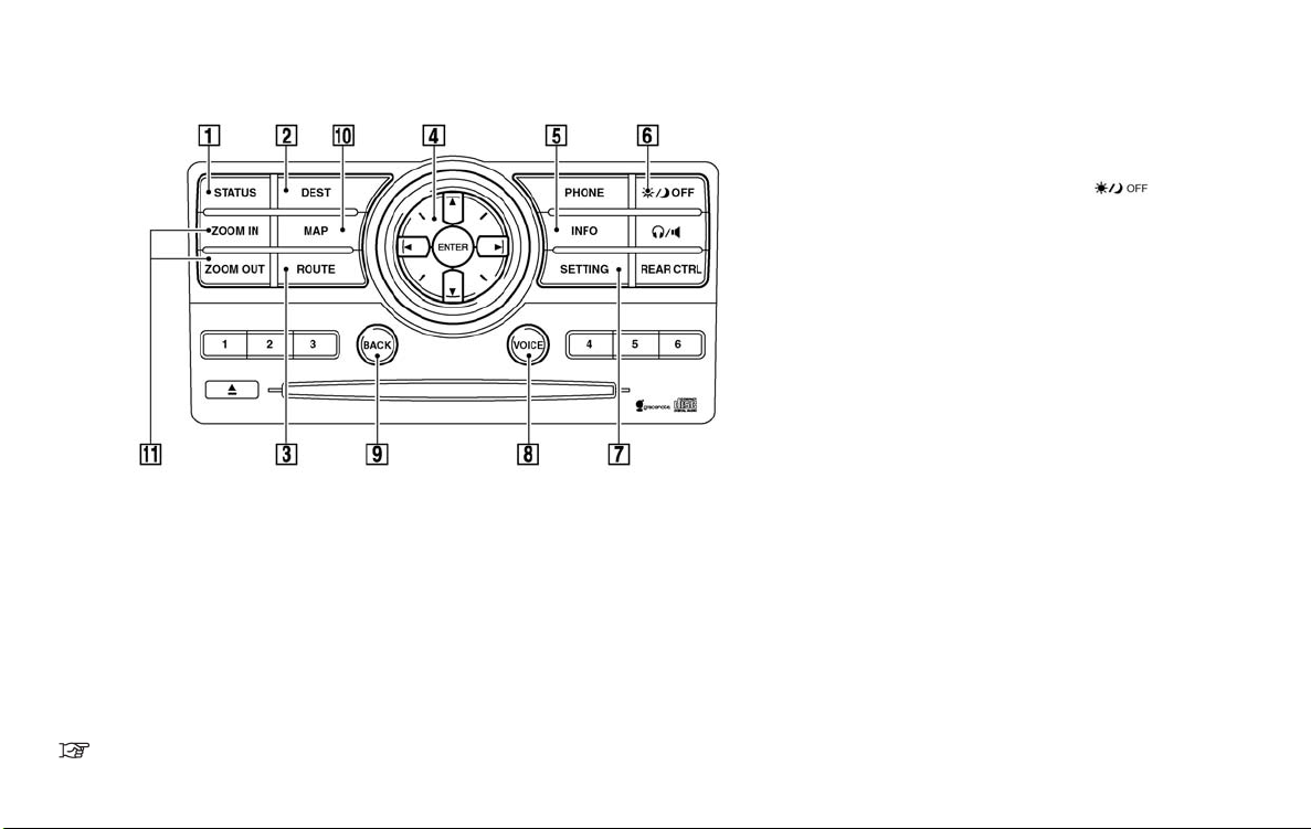
CONTROL BUTTONS AND
FUNCTIONS
CONTROL PANEL
1
&
<STATUS>:
Push to display the current status of the air
conditioner, radio, audio, vehicle information
(driveable distance and average fuel economy) and navigation systems.
2
&
<DEST>:
Push to enter a destination. Various methods
for entering a destination are available.
“4. Setting a destination”
2-2 Getting started
3
&
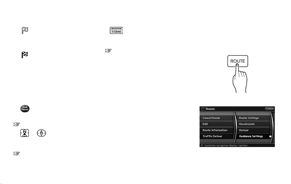
<ROUTE>:
Push to access guidance control functions
(guidance cancellation, route priority, waypoint setting on the route, etc.).
4
&
Multi-function controller:
Push to highlight an item on the screen,
select the highlighted item, move on the
map, etc.
5
&
<INFO>:
Push to display the vehicle information and
the navigation information, such as GPS and
version information, etc.
6
&
<DAY/NIGHT OFF> :
Push to switch between the day screen
(bright) and the night screen (dark) . Push
and hold to turn off the display. Push again
to turn on the display.
7
&
<SETTING>:
Push to access the system settings.
8
&
<VOICE>:
Push to repeat voice guidance for a guide
point.
9
&
<BACK>:
Push to return to the previous screen. In a
settings screen, this button can also be
used to apply the setting.
In a character input screen, this button can
also delete the characters that have been
entered.
10
&
<MAP>:
Push to display the current location map
screen.
11
&
<ZOOM IN>, <ZOOM OUT>:
Push to switch to the zoom mode to change
the map scale.
INFO:
If <BACK> needs to be pushed to apply the
setting in a settings screen, this manual will
explicitly include a step fo r this procedure.
Otherwise, pushing <BACK> returns you to
the previous screen.
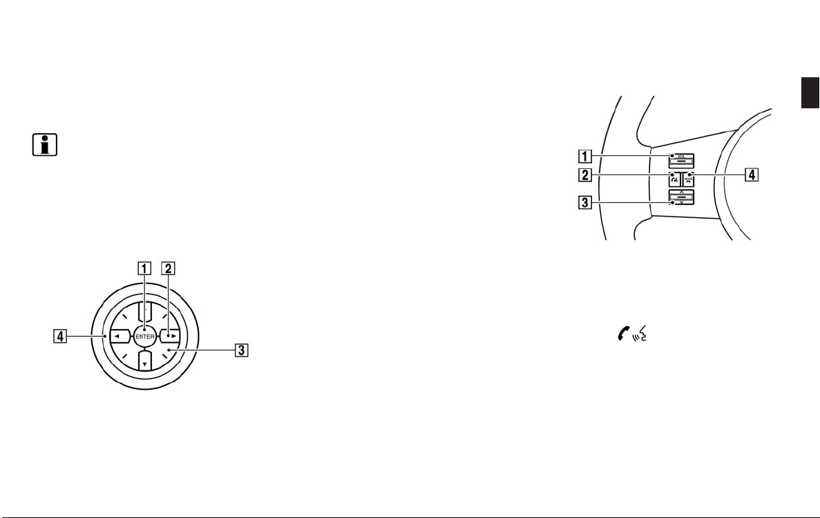
MULTI-FUNCTION CONTROLLER
1
&
<ENTER>:
Push to select the highlighted item on the
screen.
If this button is pushed while a map is
displayed, the map menu screen is displayed.
2
&
Main directional buttons:
Use to move across the map, highlight an
item on the screen or adjust a setting
(volume, brightness, etc.).
3
&
Additional directional buttons:
Use to move across the map or highlight an
item on the character input screen.
4
&
Center dial:
Turn to highlight an item on the screen or
adjust a setting.
Turn the center dial on the map screen. The
map scale is displayed. Use the center dial
to adjust the map scale.
STEERING SWITCH
1
&
<VOL>:
Use to adjust the volume. This button have
the same function as that of the volume
knob. Refer to the vehicle Owner’s Manual.
2
&
<TALK> :
Push to start the voice recognition mode.
Push and hold for 1 second to cancel voice
commands when in the voice recognition
mode.
Push and hold when not in the voice
recognition mode to display the phone
screen.
Getting started 2-3
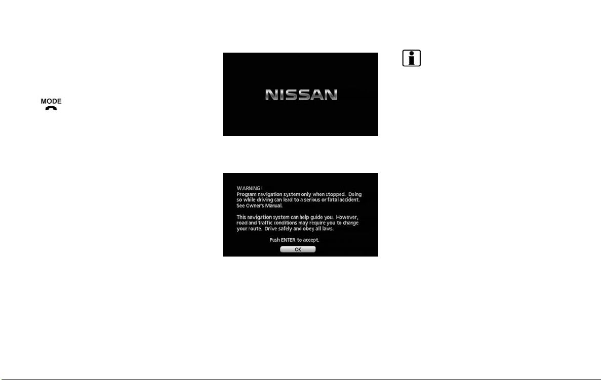
START-UP SCREEN
3
&
Tuning switch:
Use to operate the audio system. Refer to
the vehicle Owner’s Manual.
4
&
:
Push to end a call when in the phone mode.
Use to switch the audio mode (source).
Refer to the vehicle Owner’s Manual.
INFO:
If you do not push <ENTER> for more than 30
seconds, the status screen will be displayed.
Push <DEST>, <MAP>, <ROUTE>,
<INFO>, <SETTING>, <STATUS> or
<TALK> to return to the start-up screen.
1. The navigation system starts when the
ignition switch is turned to the ACC or ON
position.
2. As the start-up screen is displayed, read the
precautions carefully, highlight [OK] and
push <ENTER> or touch [OK].
2-4 Getting started
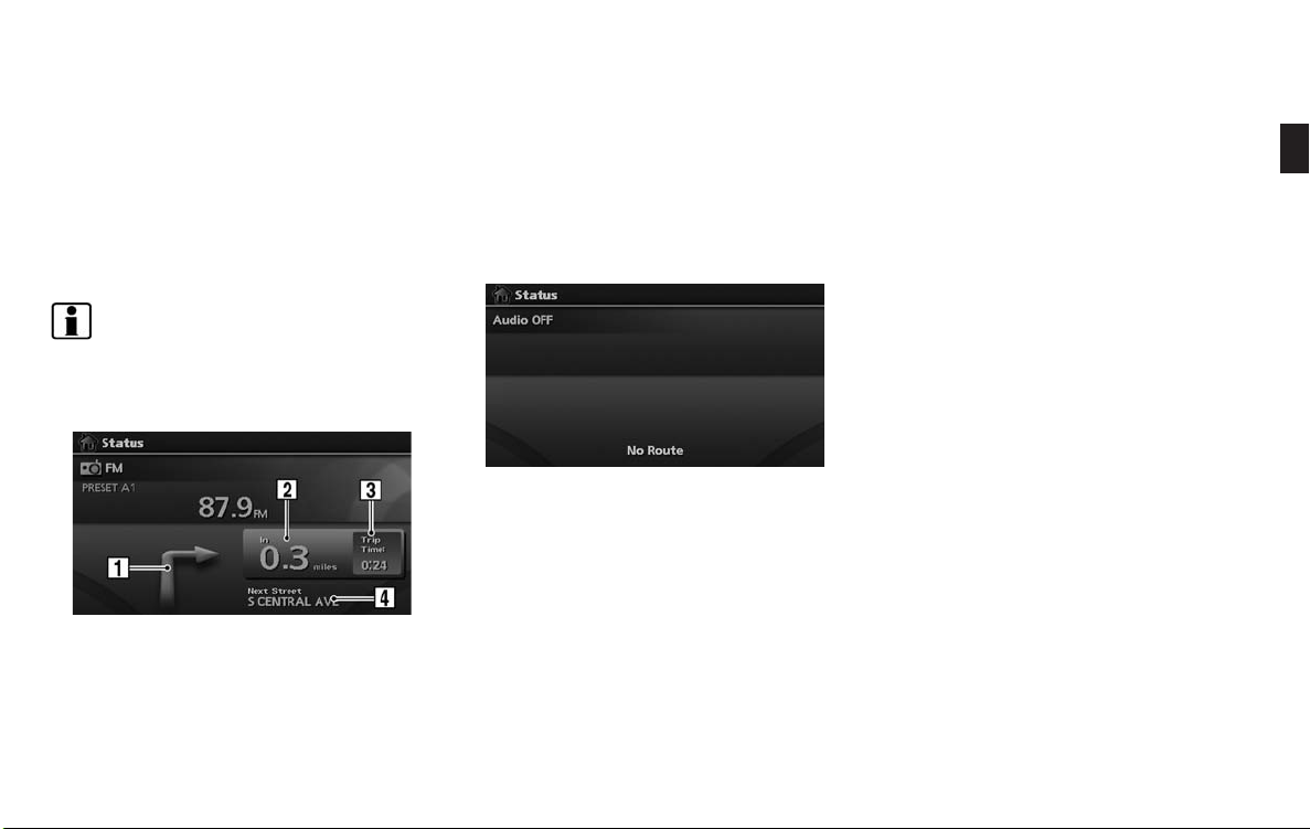
NAVIGATION SYSTEM STATUS
SCREEN
By pushing <STATUS> while the current
location map screen is displayed, you can
display the current status of the navigation
system.
Each time <STATUS> is pushed, displayed
information is switched in the order of audio, air
conditioner, vehicle information and navigation
route information.
INFO:
There are different status screens displayed
depending on various factors, such as the
currently active mode, whether a destination
has been set or not, etc.
When a route to the destination is set and the
audio system is on, a screen similar to the one
above appears.
1
&
Turning direction at the next intersection
2
&
Distance to the next intersection
3
&
Remaining time to the destination
4
&
Name of the next street
When a route to the destination is not set and
the audio system is off, a screen similar to the
one above appears.
Getting started 2-5
FUNCTIONS DISABLED WHILE
DRIVING
To ensure safe driving, some functions cannot
be operated while driving.
The on-screen functions that are not available
while driving will be “grayed-out” or muted.
In some cases, certain text will not be displayed
on the screen.
Park the vehicle in a safe location and then
operate the navigation system.
2-6 Getting started

MENU SCREEN AND HOW TO
OPERATE
INFO:
. Some items in the menu contain further
details, which are displayed on the right
side of the screen when the menu item
is highlighted. This allows you to preview
details of the item. These details appear
only on the menu screen displayed by
pushing <DEST>.
. Depending on the menu selected, push-
ing <MAP> may not return you to the
current location map screen.
MENU SCREENS AND THEIR PURPOSES
Push <DEST>, <ROUTE>, <PHONE>,
<INFO> or <SETTING> to display the corresponding menu screen.
How to select a menu item
Example: <DEST> screen
1. Turn the center dial clockwise or counterclockwise or push the up or down button of
the main directional buttons. An item is
highlighted accordingly.
2. To select the preferred menu item, highlight
the item and push <ENTER>. The next
screen is displayed.
3. Push <BACK> to return to the previous
screen without applying any changes.
Push <MAP> to return to the current
location map screen without applying any
changes.
Getting started 2-7
INFO:
This same adjustment can also be made by the
touch panel operation.
“Adjusting the volume and others”
(page 2-10)
USING CONTROLS TO ADJUST VALUES, LEVELS, ETC.
There are four main methods you can use to
control the navigation system: the center dial,
the main directional buttons and the touch
panel. Use these controls to adjust the volume
of phone and voice guidance, the display
brightness, etc.
2-8 Getting started
How to adjust
1. Highlight the preferred setting item and
push <ENTER>. The color of the corresponding adjustment item changes.
2. Use one of the controls, and the value or bar
indicating levels increases or decreases
accordingly.
3. Push <ENTER> or <BACK> to apply the
setting.
the selected item. Turn the center dial or
push the up or down buttons of the main
directional buttons to scroll the list.
5
&
Highlight and push <ENTER> to sort the
list by shortest distance.
6
&
Highlight and push <ENTER> to sort the
list in the original order.
7
&
When the list is sorted by the shortest
distance, you can confirm the selected
location in the preview on the right side of
the screen.
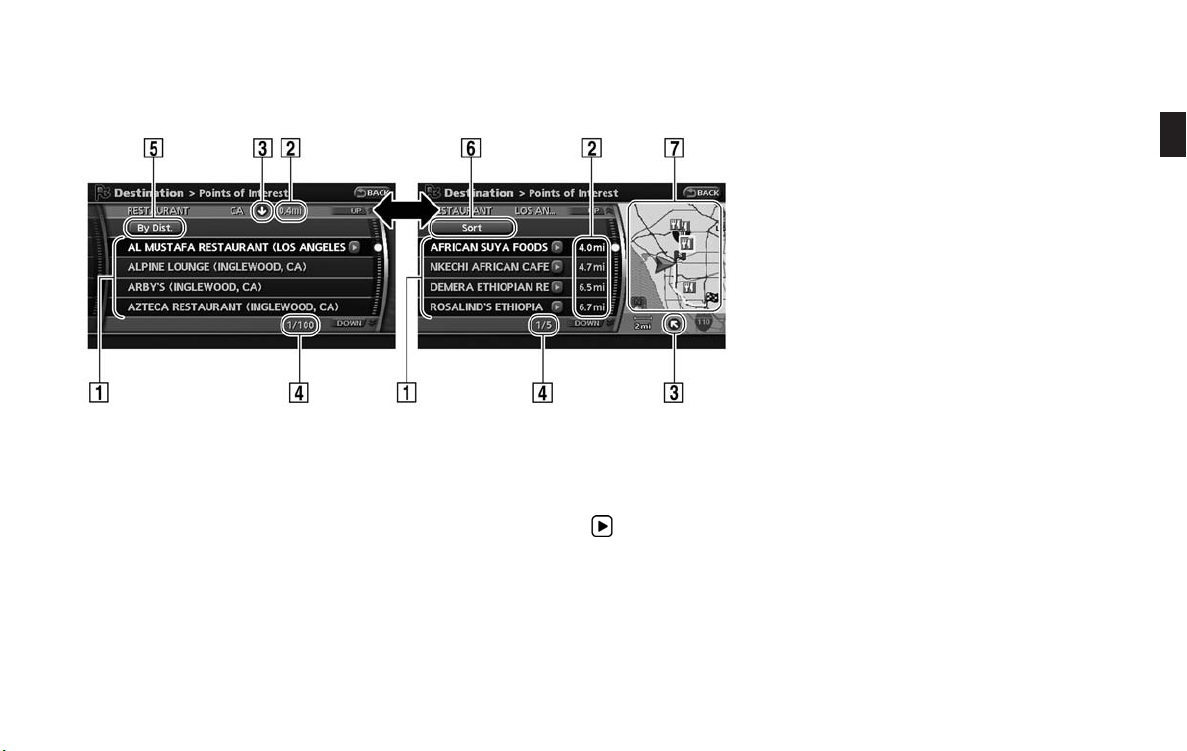
LIST SCREEN
After searching for a point of interest, a list
screen is displayed.
Depending on the list displayed, it can be
sorted.
Items displayed in a list
1
&
Highlight the preferred item from the list and
push <ENTER> to select it.
If a location or facility name is not completely
displayed (due to length) , highlight the item
and push the right button of the main
directional buttons to show the hidden part
of the name.
You can also display the hidden part of the
name by touching
2
&
Distance from the current location
3
&
Direction to the point of interest
4
&
If the entire list cannot be displayed on the
screen, the system displays the total number
of items in the list and the entry number of
.
Getting started 2-9
TOUCH PANEL OPERATION
With this system, the same operations as those
for the multi-function controller are possible
using the touch panel operation.
This manual describes the operations using the
multi-function controller.
For the operations that differ from those of the
multi-function controller and for useful methods
for using the touch panel operation, refer to each
section.
EXAMPLE OF TOUCH PANEL OPERATION
Here, the operation examples performed with
the touch panel operation are described.
Selecting the item
When the item is touched, the following screen
is displayed.
Adjusting the volume and others
Touch [+] or [−] located on the right and left of
the bar graph to perform the adjustment.
Scrolling the message or list
Touching [UP] or [DOWN] allows you to scroll
the message or list.
Inputting letters and numbers
1. Touch the letter or number.
2. When you desire to delete a character,
touch [Delete]. Push and hold [Delete] to
delete all of the characters.
2-10 Getting started
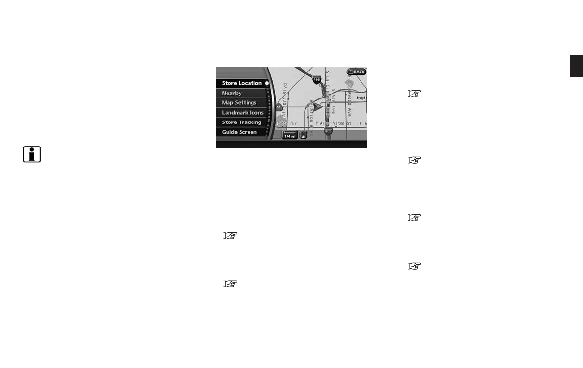
MAP MENU SCREEN
Push <ENTER> while the current location map
screen or a scrolled map screen is displayed to
display the menu corresponding to that screen.
This menu allows you to quickly use helpful
functions, such as setting a destination easily
and searching for Points of Interest nearby.
To select a menu item, use the method
described in “Menu screen types and how to
operate”.
INFO:
With the touch operation, the same screen can
be displayed by touching [Map Menu] located
on the map screen.
CURRENT LOCATION MAP SCREEN
If <ENTER> is pushed while the current
location map screen is displayed, the following
options are available.
. Store Location:
Allows you to store the current vehicle
location in the Address Book. The stored
location can be retrieved as necessary to set
it as a destination (waypoint).
“STORING A LOCATION” (page 6-2)
. Nearby:
Allows you to search for points of interest
near the current vehicle location, such as
restaurants and gas stations, etc.
“SETTING A NEARBY PLACE”
(page 4-14)
. Map Settings:
Performs the map operations such as the
switching of map type and the setting of
map orientation and scale.
“OTHER SETTINGS FOR THE MAP
SCREEN” (page 3-12)
. Landmark Icons:
Allows you to display certain poin ts of
interest near the current vehicle location on
the map, such as restaurants and gas
stations, etc.
“DISPLAYING LANDMARK ICONS”
(page 3-19)
. Store Tracking:
Allows you to store in the Address Book the
route that you have travelled from the
starting point to the current location.
“STORING A TRACKED ROUTE”
(page 6-6)
. Guide Screen:
Set the default display screen for route
guidance.
“Visual guidance settings”
(page 5-19)
Getting started 2-11
STORING YOUR HOME LOCATION/
ADDRESS
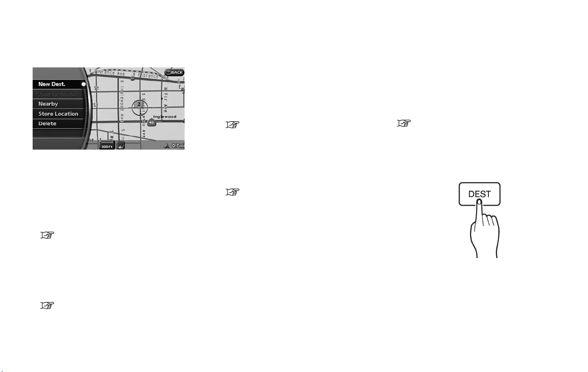
SCROLLED LOCATION MAP SCREEN
If <ENTER> is pushed while a scrolled map
screen is displayed, the following options are
available.
. New Dest.:
Allows you to set the destination to the
location where you pushed <ENTER>.Ifa
destination is already set, the location will be
set as the new destination.
“SETTING FROM MAP” (page 4-23)
. Add to Route:
Allows you to set the location where you
pushed <ENTER> as the destination or a
waypoint.
This is available only when the suggested
route is already set.
“Setting a destination or waypoint”
(page 5-8)
. Nearby:
Allows you to search for points of interest
near the location where you pushed
<ENTER> and set it as a destination or
waypoint.
Use the same search method as the one for
POI.
“SETTING A NEARBY PLACE”
(page 4-14)
. Store Location:
Allows you to store the location where you
pushed <ENTER> in the Address Book.
The stored location can be retrieved to set it
as a destination or waypoint.
“STORING A LOCATION” (page 6-2)
. Delete:
Allows you to delete a stored location,
destination or waypoint. To delete it, place
the cross pointer over the corresponding
icon.
. Incident Details:
Can be selected only when the traffic
information icon is displayed.
Displays the details of the traffic information
icon that is being displayed.
Place the cross pointer over the icon you
desire to check.
HOW TO STORE YOUR HOME
If your home location is already stored in the
Address Book, it can be easily retrieved to set
the route to your home.
The procedure to store your home location is the
same as for storing any other location.
“4. Setting a destination”
As an example, the procedure for storing your
home location by searching for a destination by
address is described here.
1. Push <DEST>.
2-12 Getting started
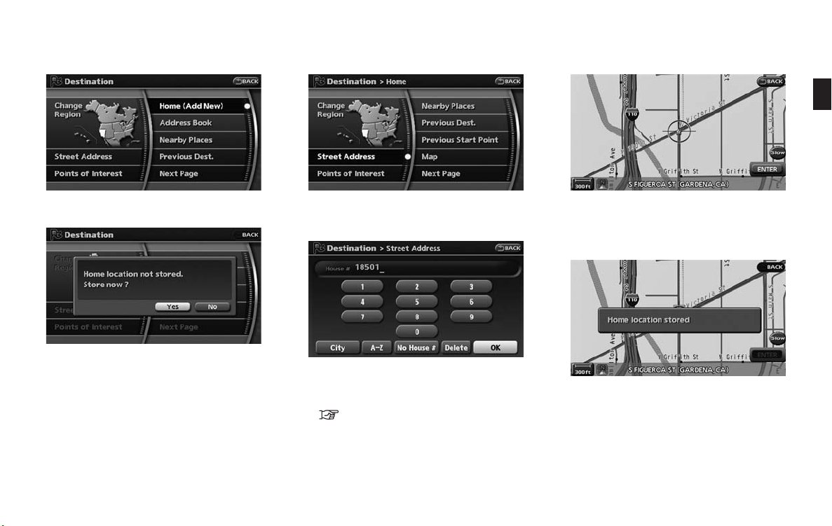
2. Highlight [Home Location (Add New)] and
push <ENTER>.
3. A confirmation message is displayed. Confirm the contents of the message, highlight
[Yes] and push <ENTER>.
4. Highlight [Street Address] and push
<ENTER>. A character input screen is
displayed.
5. Enter the address of your home, highlight
[OK] and push <ENTER>.
The map screen is displayed.
“SETTING A STREET ADDRESS”
(page 4-4)
6. Pushing the directional buttons, adjust your
home location if necessary.
7. After adjusting the location, push
<ENTER>.
8. A message is displayed and your home
location is stored.
9. Push <MAP> to return to the current
location map screen.
The home icon is displayed on the map.
Getting started 2-13
SETTING A DESTINATION
INFO:
You can also perform the same setting by
pushing <SETTING> and selecting [Navigation].
“STORING A LOCATION BY SEARCHING” (page 6-2)
SEARCHING FOR A DESTINATION
As an example, the method for setting an airport
as the destination using [Points of Interest] is
described here.
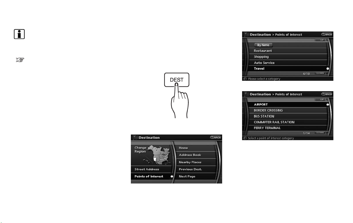
3. Highlight [Travel] and push <ENTER>.
1. Push <DEST>.
4. From the category list, highlight [AIRPORT]
and push <ENTER>.
2. Highlight [Points of Interest] and push
<ENTER>.
2-14 Getting started
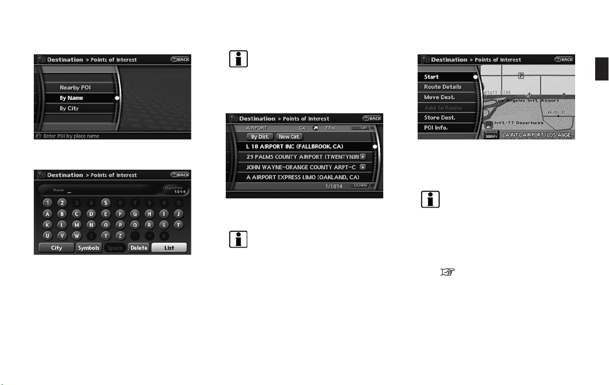
INFO:
You can enter the city name and facility
name to narrow down your search.
The number of narrowed down points are
displayed in the “Matches” column.
5. Highlight [By Name] and push <ENTER>.
A character input screen is displayed.
6. Highlight [List] and push <ENTER>.
A list screen is displayed.
7. Highlight the preferred airport from the list
and push <ENTER>.
INFO:
. By selecting [By Dist.], you can sort the
list by the shortest distance.
. The position of the selected location is
displayed in the preview on the right
side of the screen.
8. The selected destination is displayed at the
center of the map. Highlight [Start] after
confirming the location of the displayed
destination, and push <ENTER>.
INFO:
. The system sets the destination to the
selected location and starts calculating
a route.
. Even after setting a destination, you can
adjust the location of the destination,
store the route, etc. if necessary.
“OPERATIONS AFTER SETTING
A DESTINATION” (page 4-24)
Getting started 2-15
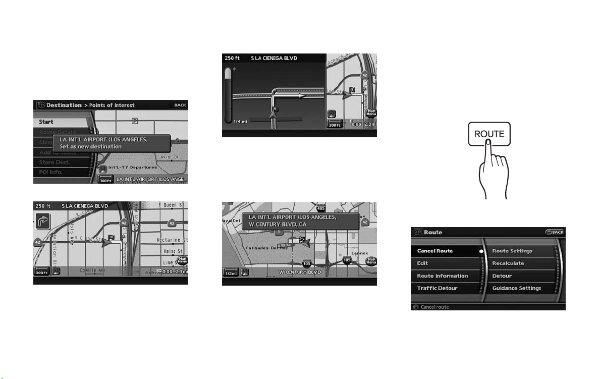
STARTING ROUTE GUIDANCE
After setting the destination and performing
route calculation, the suggested route is displayed.
1. Highlight [Start] and push <ENTER>.
DELETING A ROUTE
To delete a route already set, use the following
procedure. If you delete a route, the destination
is also deleted.
3. When approaching a guide point, the
system automatically changes to the split
screen and shows an enlarged view of the
intersection in the left screen.
Push <MAP> to switch to the full map
screen.
1. Push <ROUTE>.
2. Once route guidance is started, the system
navigates you through the guide points
using visual and voice guidance.
2-16 Getting started
4. When arriving at the destination, route
guidance automatically ends.
2. Highlight [Cancel Route] and push
<ENTER>.
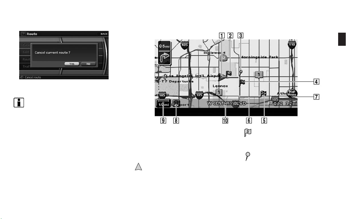
3. A confirmation message is displayed. Highlight [Yes] and push <ENTER>.
INFO:
If a route is cancelled, [Cancel Route] changes
to [Resume Route].
Highlight [Resume Route] and push <ENTER>
to reactivate the cancelled route.
This is available only until a new route is set.
OPERATING MAPS
HOW TO VIEW MAP SCREEN
The navigation system displays various information on the map screen.
Screen information
1
&
Vehicle icon:
Indicates the current vehicle location and
the direction that you are traveling.
2
&
3
&
Starting point:
Displays the vehicle location, with which the
route is set, as the starting point.
Guide point:
Indicates a guide point on the route.
Getting started 2-17
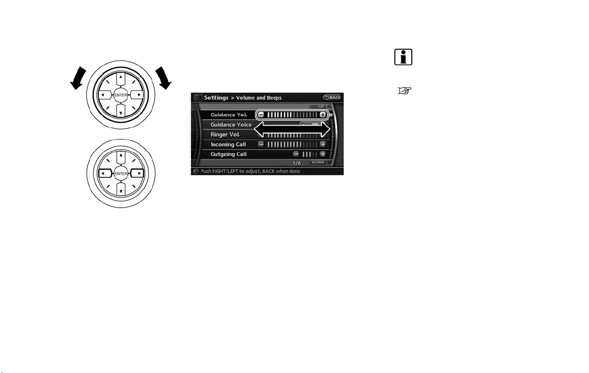
SETTING THE VOICE GUIDANCE
4
&
5
&
6
&
7
&
8
&
Waypoint:
Displays the locations that you travel past
when going to the destination. A maximum
of 5 waypoints can be set.
Destination:
Indicates the destination location of the
route guidance.
When the map scale is 300 ft or less in Plan
View, or 1/4 mile or less in Birdview: The
name is displayed on the map screen.
Suggested route:
Appears in bold yellow during route gui-
dance.
Map Menu icon:
Touch the icon to display the Map Menu
screen.
“MAP MENU SCREEN” (page 2-11)
/ Direction indicator:
Indicates the direction of the map.
Touch the icon to switch the direction of the
map.
“SETTINGS OF HEADING/LONG
RANGE MAP VIEW” (page 3-14)
9
&
10
&
Scale indicator:
Indicates the scale of the map.
Touch the icon to display the scale bar. This
allows the map scale to be adjusted.
“OPERATING WITH THE TOUCH OPERATION” (page 3-10)
Street name:
Displays the name of the street that you are
currently driving on.
TURNING VOICE GUIDANCE ON/OFF
You can activate or deactivate voice guidance
and adjust the volume.
1. Push <ROUTE>.
2. Highlight [Guidance Settings] and push
<ENTER>.
2-18 Getting started
<ENTER>.
ADJUSTING VOICE GUIDA NCE VOLUME
You can adjust the volume of voice guidance.
3. Highlight [Guidance Voice] and push
<ENTER>. The indicator illuminates if voice
guidance is activated.
Other settings
You can also activate or deactivate voice
guidance using the following procedure.
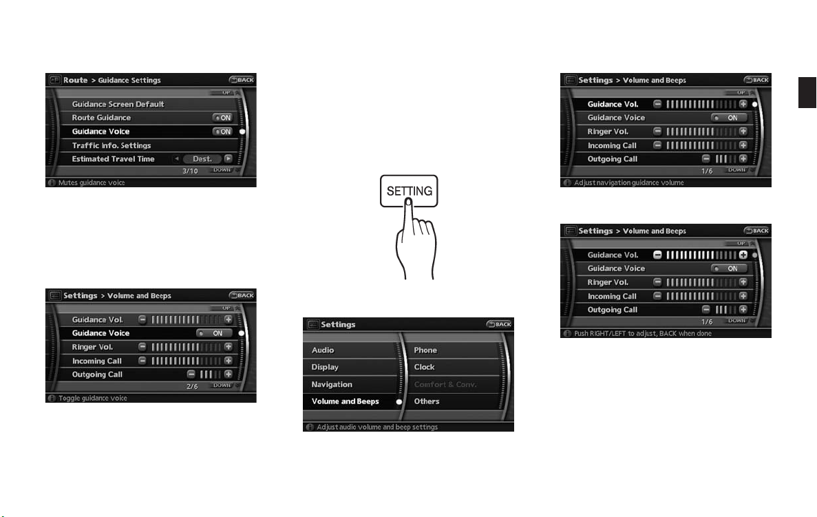
1) Push <SETTING>.
2) Highlight [Volume and Beeps] and push
<ENTER>.
3) Highlight [Guidance Voice] and push
3. Highlight [Guidance Vol.] and push
<ENTER>.
1. Push <SETTING>.
4. Adjust the voice guidance volume by using
the center dial or main directional buttons.
2. Highlight [Volume and Beeps] and push
<ENTER>.
Getting started 2-19
INFO:
You can also adjust the volume by turning the
audio system volume knob or tilting <VOL> on
the steering switch while voice guidance is
being announced.
HOW TO INPUT LETTERS AND
NUMBERS
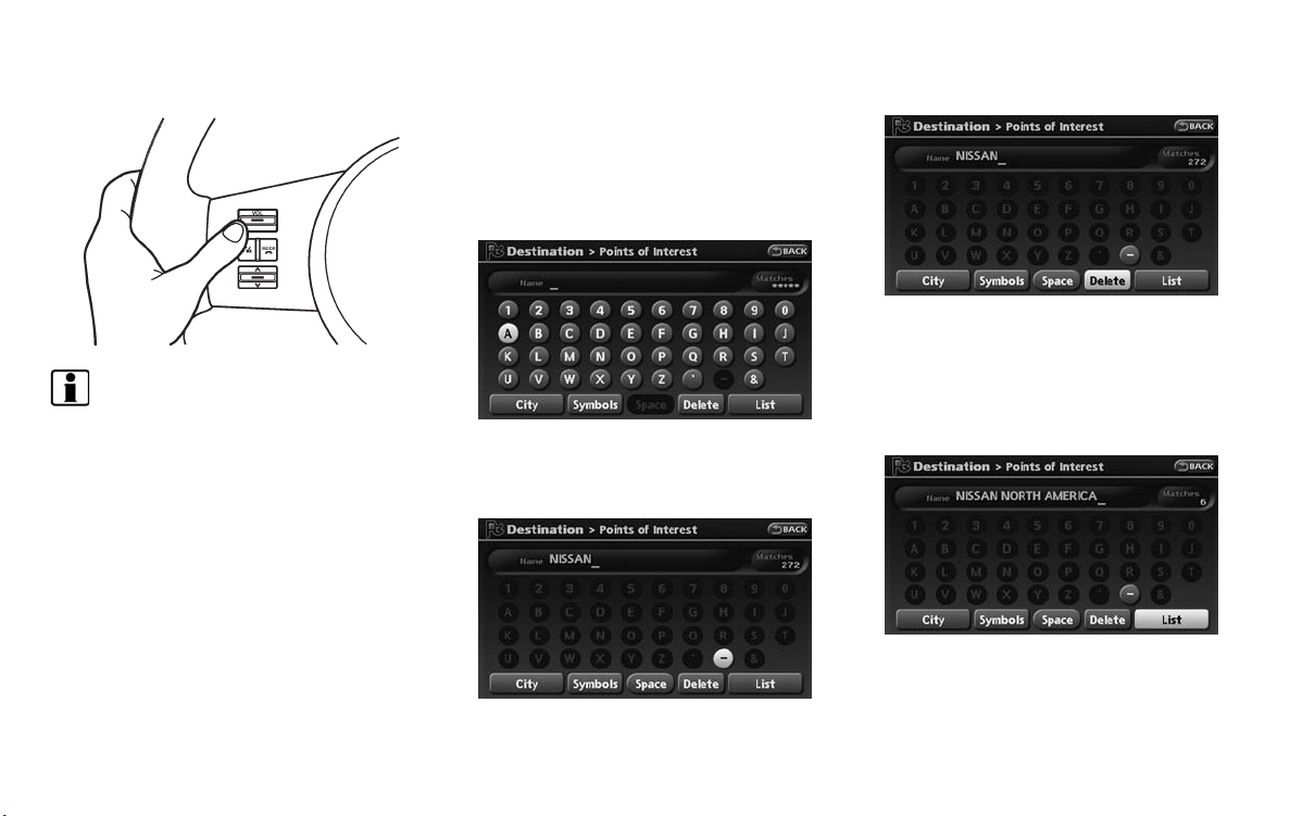
CHARACTER (letter and number) INPUT
SCREEN
You will have to enter alphanumeric characters
when setting a destination, searching for a
facility or editing the stored locations, etc.
1. Use the touch panel, center dial, main
directional buttons or additional directional
buttons to highlight a ch aracter on the
displayed keyboard.
3. Push <BACK>, or highlight [Delete] and
push <ENTER> to delete the last character
entered.
Push and hold <BACK> to delete all the
characters entered.
Highlight [Space] and push <ENTER> to
enter a space.
4. After finishing the entry, highlight [List] and
push <ENTER>.
2-20 Getting started
2. Push <ENTER>. The highlighted character
is entered.
INFO:
. You can push <BACK> on the control
panel to return to the previous screen,
but only after deleting all the characters
entered.
. When you touch [BACK] on the screen,
the screen returns to the previous
screen even when characters have been
entered.
. When the character tha t you have
entered can only be followed by one
other character, that character is entered automatically.
. When you have entered text and nar-
rowed down the matching list items to a
number that will fit on the screen, the list
screen appears automatically.
. Symbol keys are displayed by high-
lighting [Symbols] and pushing
<ENTER>. Alphabet keys are displayed
by highlighting [A-Z] and pushing
<ENTER>.
Symbol input screen
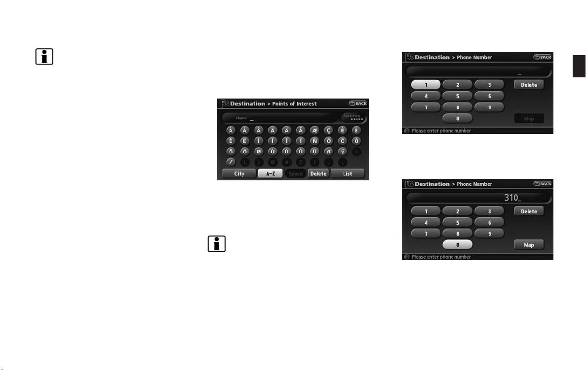
PHONE NUMBER INPUT SCREEN
You can enter a phone number as a search
method to look for a point of interest.
INFO:
Only the locations included in the database in
the map data can be searched by the phone
number.
1. Use the touch panel, center dial, main
directional buttons or additional directional
buttons to highlight a number on the
displayed keyboard.
2. Push <ENTER>. The highlighted number is
entered.
Getting started 2-21
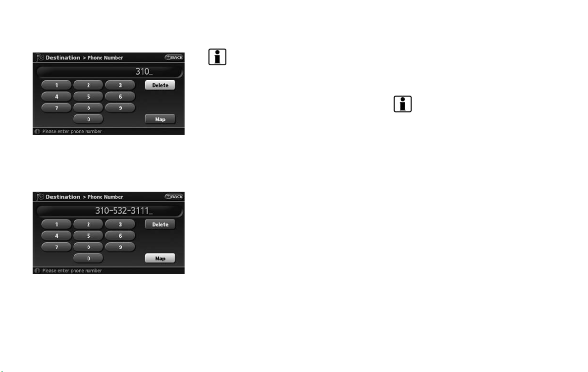
NISSAN VOICE RECOGN ITION
3. Push <BACK>, or highlight [Delete] and
push <ENTER> to delete the last number
entered.
Push and hold <BACK> to delete all the
numbers entered.
4. After finishing the entry, highlight [Map] and
push <ENTER>.
INFO:
. You can push <BACK> on the control
panel to return to the previous screen, but
only after deleting all the numbers entered.
. When you touch [BACK] on the screen, the
screen returns to the previous screen even
when numbers have been entered.
NISSAN Voice Recognition allows hands-free
operation of the navigation system and other
systems equipped on this vehicle, such as the
display, audio, climate control and phone.
INFO:
For the voice commands for the audio, air
conditioner and other systems (except navigation system), refer to the vehicle Owner’s
Manual.
CONFIRMING VOICE COMMANDS
If you are controlli ng the system by voice
commands for the first time or do not know the
appropriate voice command, confirm the voice
command lists.
The following information describes how to
display the navigation command list and the
help list. For information about the operations of
other functions, refer to the vehicle Owner’s
Manual.
2-22 Getting started
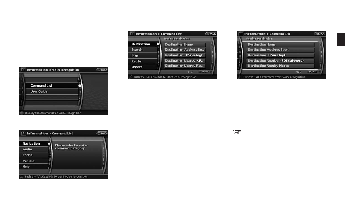
Example: Displaying the navigation command list
1. Push <INFO>.
2. Highlight [Others] and push <ENTER>.
3. Highlight [Voice Recognition] and push
<ENTER>.
4. Highlight [Command List] and push
<ENTER>.
5. Highlight [Navigation] and push <ENTER>.
6. Highlight the preferred item and push
<ENTER>.
Available items:
. Destination:
Allows you to set a destination.
. Search:
Allows you to search for a location.
. Map:
Allows you to change the map settings.
. Route:
Allows you to set a route in detail.
. Others:
Allows you to store locations or set the
route guidance.
7. You can confirm the list by scrolling the
screen using the up and down switches of
the main directional buttons or the center
dial.
8. Press <BACK> to return to the previous
screen.
For further details about the displayed command
list, refer to section 9.
“Command List” (page 9-3)
BEFORE STARTING
To get the best recognition performance out of
NISSAN Voice Recognition, observe the following:
. The interior of the vehicle should be as quiet
as possible. Close the windows to eliminate
the surrounding noises (traffic noise and
vibration sounds, etc.), which may prevent
the system from correctly recognizing the
voice commands.
Getting started 2-23
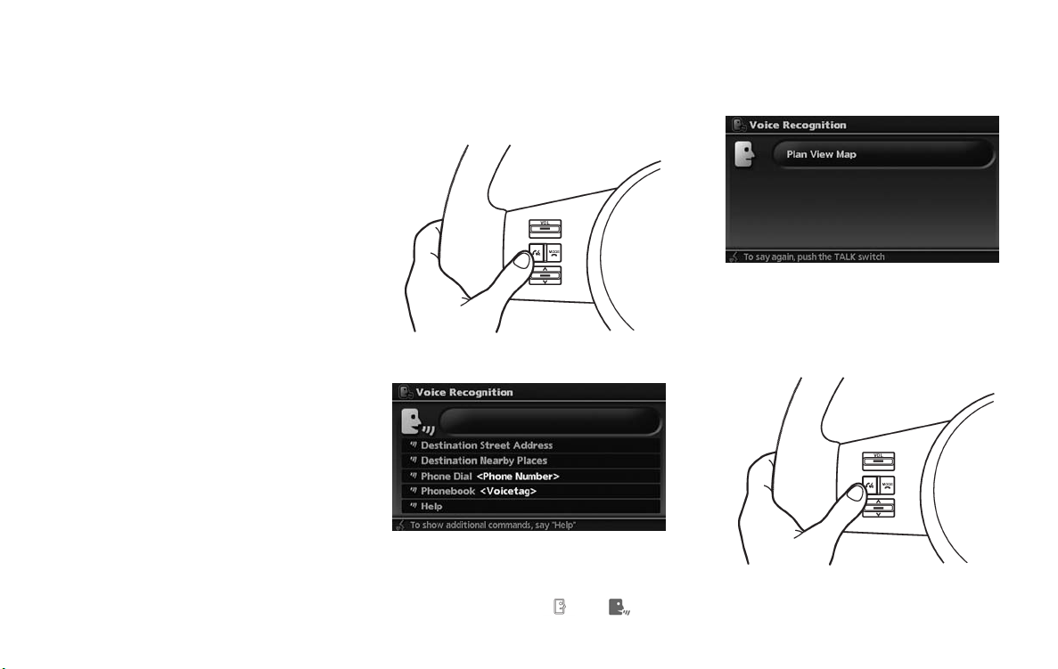
. Wait until the tone sounds before speaking a
command. Otherwise, the command will not
be recognized properly.
. Speak in a na tural con versational voice
without pausing between words.
. If the air conditioner is set to “Auto”, the fan
speed is automatically lowered so that your
commands can be recognized more easily.
VOICE COMMAND EXAMPL ES
To use the voice recognition function, speaking
one command is sometimes sufficient, but at
other times it is necessary to speak two or more
commands.
As examples, some additional basic operations
by voice commands are described here.
2-24 Getting started
Example 1: Switching the map to the
Plan View mode
1. Push <TALK> located on the steering
switch.
2. The system announc es, “Please say a
command”.
3. After the tone sounds and the icon on the
screen changes from [
]to[ ], speak
“Plan View Map”.
4. Voice feedback will be provided when the
command is accepted, and the map is
displayed in Plan View.
Example 2: Setting a destination using a
nearby place
1. Push <TALK> located on the steering
switch.

2. The system announc es, “Please say a
command”.
3. After the tone sounds and the icon on the
screen changes from [
“Destination nearby places”.
4. Voice feedback will be provided when the
command is accepted, and the list of POI
categories appears.
5. After the tone sounds and the icon on the
screen changes again, speak “Three”.
]to[ ], speak
6. If a route is already set, choose “Along
Route” or “Nearby”.
7. After the tone sounds and the icon on the
screen changes again, speak “Along Route”.
8. Voice feedback will be provided when the
command is accepted, and the list of Points
of Interest in the category specified in the
previous step appears.
9. After the tone sounds and the icon on the
screen changes again, speak “Three”.
10. Voice feedback will be provided when the
command is accepted, and the system
starts calculating a route to the selected
facility.
Example 3: Setting a destination by a
street address
1. Push <TALK> located on the steering
switch.
Getting started 2-25

2. The system announc es, “Please say a
command”.
3. Speak “Destination street address”.
INFO:
. Only the official street names stored in
the map data can be recognized by the
system.
. You need to speak the street name
precisely including boulevard, way,
north, south, etc. In this case, you
cannot speak “Figueroa street” or “Figueroa”.
5. Speak the name of the city, “Gardena”.
4. Speak the name of the state, “California”.
2-26 Getting started
6. Speak the name of the street, “South
figueroa street”.
7. Voice feedback will be provided when the
command is accepted, and the list of street
names appears.
8. After the tone sounds and the icon on the
screen changes again, speak “One”.

9. Speak the house number.
“How to speak numbers” (page 9-10)
INFO:
If you do not know the house number, speak
“No house number”.
10. To confirm the destination location on the
map, speak “Show map”. To calculate a
route, speak “Calculate route”.
Getting started 2-27

MEMO
2-28 Getting started

3 Map settings
Map types ........................................................ 3-2
Plan view ..................................................... 3-2
Birdview
Building graphics ........................................... 3-3
Returning to the current vehicle location .................. 3-4
Operating with the touch operation .................... 3-5
Moving a map ................................................... 3-5
Plan view ..................................................... 3-5
Birdview
Changing the scale of a map ................................ 3-9
Operating with the buttons on the control panel .... 3-9
Operating with the center dial ......................... 3-10
TM
.................................................... 3-3
TM
.................................................... 3-7
Operating with the touch operation .................. 3-10
Map scale .................................................. 3-11
Other settings for the map screen........................ 3-12
Switching the map view................................. 3-12
Settings of heading/long range map view........... 3-14
Changing the Birdview
Operation with split screen display ................... 3-18
Looking at information on the map ....................... 3-19
Displaying landmark icons .............................. 3-19
Map scrolling information ............................... 3-20
Map symbols. .............................................. 3-22
TM
angle ....................... 3-16

MAP TYPES
Two types of map views are available: Plan View
and Birdview
TM
.
PLAN VIEW
Plan View displays the map in a 2-dimensional
environment similar to a road map.
3-2 Map settings
Screen information
1
&
2
&
3
&
Vehicle icon:
Indicates the current vehicle location and
the direction that you are traveling.
Guide point:
Indicates a guide point on the route.
Remaining time and distance to the
destination:
Indicates the approximate remaining time
and distance to the destination or waypoint.
This indicator will appear when you set the
destination or waypoint and start route
guidance.
When you are not driving on the suggested
route, the screen displays the direction to
the destination and the distance to the
destination from the current vehicle position.
4
&
Suggested route:
Appears in bold yellow during route gui-
dance.

5
&
/ Direction indicator:
Indicates the direction of the map.
Touch the icon to switch the direction of the
map.
6
&
Scale indicator:
Indicates the scale of the map.
Touch the icon to display the scale bar.
This allows the map scale to be adjusted.
7
&
Arrow:
Indicates the distance to the next guide
point and the turning direction at that guide
point.
8
&
Stored location:
Displays the locations that are stored in the
Address Book. You can change the icons
according to your preferences.
9
&
Avoid Area:
Displays the areas to avoid that are stored in
the Address Book with green or blue icons.
During the route search, the route guidance
is performed by searching for a route that
avoids those areas.
10
&
Street name:
Displays the name of the street that you are
currently driving on.
11
&
Traffic indicator:
Displays the reception condition of traffic
information transmitted from the provider.
Green: Reception condition is good.
Gray: Reception condition is not good.
No mark: Subscription to XM
®
NavTraffic
TM
service is not detected.
Birdview
BirdviewTMdisplays the map from an elevated
perspective. In Birdview
TM
TM
, it is easy to recognize an image of the route because it provides a
panoramic view over a long distance.
INFO:
About the Birdview
. “Birdview
TM
TM
display
” is a registered trademark of
Xanavi Informatics Corporation.
. The map in Birdview
TM
always appears with
the current forward direction facing up.
BUILDING GRAPHICS
In the area where the building graphics are
stored in the map data, the building graphics are
displayed when the map is zoomed in. On the
Plan View display, these are called “Building
footprint graphics”, and on the Birdvie w
display, these are called “3D building graphics”.
How to look at the map is the same for Plan
View and Birdview
Building footprint graphics (Plan View)
TM
.
TM
Map settings 3-3

3D building graphics (BirdviewTM)
INFO:
In the area where the building graphics are not
stored in the map data, the normal map is
displayed even when the map is zoome d in.
RETURNING TO THE CURRENT
VEHICLE LOCATION
3-4 Map settings
The basic map screen displays the current
location (the position where the vehicle mark is
located). The current location can be displayed
again even after the map is moved, or after the
menu screen or the guide screen is displayed.
Push <MAP>. The current location map screen
is displayed.
INFO:
Depending on the menu selected, pushing
<MAP> may not return you to the current
location map screen.
Setting by voice command
1. Push <TALK> located on the steering
switch.
2. After the tone sounds, speak a command.
To display the current location map screen:
“Show Current Location”

OPERATING WITH THE TOUCH OPERATION
Touch [BACK] on the map screen to display the
current location map screen.
MOVING A MAP
The operations for moving across the map are
different between Plan View and Birdview
TM
.
PLAN VIEW
Operating with the multi-function con-
troller
Push one of the main directional buttons or
additional directional buttons corresponding to
the direction that you want to move across the
map. Hold down the button to continuously
move across the map in that direction.
Once you start moving across the map, the
cross pointer appears.
If the map scale is set to 1/8 mile (200 m) or
less, the cross pointer will blink in pink when
positioned on a street, and the street name will
be displayed.
Screen information:
1
&
Cross pointer
2
&
Distance from the current location to the
cross pointer
Map settings 3-5

3
&
Street name
Operating with the touch operation
1. Touch the screen.
Displays the cross pointer, and the touched
position is set as the center of the screen.
2. Touch the direction you desire to scroll to.
The map continues to scroll while the screen
is touched.
INFO:
When the operation is performed during driving,
the scrolling is stopped after the screen scrolls
to the touched direction for a specified amount.
If the map screen is set to the building footprint
graphics, the map cannot be scrolled while
driving.
Fine-adjusting the cursor position:
2. Touch the 8-directional key to adjust the
cross pointer position.
Touch [BACK] to end the adjustment.
INFO:
Fine-adjusting the cursor position is not possible
while driving.
1. Touch [Slow].
Displays the 8-directional key.
3-6 Map settings

Screen information:
1
&
Cross pointer
2
&
Distance from the vehicle position to the
cross pointer
3
&
Street name
Operating with the touch operation
Birdview
TM
Operating with the multi-function controller
The main directional buttons and additional
directional buttons allow movement in the
following ways.
Hold down one of the main directional buttons
or additional directional buttons to continue to
rotate or move across the map in that direction.
Rotates the map clockwise.
Rotates the map counterclockwise.
The cross pointer moves in the direction of the arrow.
Once you start moving on the map, the cross
pointer appears.
1. Touch the screen.
Displays the cross pointer and 8-directional
key.
Map settings 3-7

2. Touch the direction you desire to scroll to.
The map continues to scroll while the screen
is touched.
3. Touch [ ]or[ ] to change the
direction of the map.
:Rotates the map clockwise.
:Rotates the map counterclockwise.
INFO:
When the operation is performed during driving,
the scrolling is stopped after the screen scrolls
to the touched direction for a specified amount.
If the map scale is set to 180 ft (60 m) or less,
the map cannot be scrolled while driving.
3-8 Map settings

CHANGING THE SCALE OF A MAP
OPERATING WITH THE BUTTONS ON
THE CONTROL PANEL
Push <ZOOM IN> or <ZOOM OUT>. A scale
appears on the left side of the screen.
To view the map in detail, push <ZOOM IN>.
To view a wider area, push <ZOOM OUT>.
The scale will automatically disappear when
neither <ZOOM IN> nor <ZOOM OUT> has
been pushed for several seconds.
If the scaling operation is not performed for a
specified period of time, the scale display
disappears.
INFO:
Free zoom:
Once the Free Zoom is set in the setting screen,
the scale can be changed in smaller steps when
you push and hold <ZOOM IN> or <ZOOM
OUT> than when you briefly push the button.
If you briefly push the button, the operation
returns to normal.
Map settings 3-9

OPERATING WITH THE CENTER DIAL
OPERATING WITH THE TOUCH OPERATION
1. Touch .
Displays the scale.
1. Turn the center dial on the map screen. The
map scale is displayed.
2. Use the center dial to adjust the map scale.
1
&
Clockwise: Zoom in
2
&
Counterclockwise: Zoom out
3-10 Map settings
INFO:
Free zoom:
Depending on the setting, using the center dial
to change the map scale may adjust the scale
normally, or it may engage the free zoom (finer
scale adjustment in smaller steps).
“NAVIGATION SETTING” (page 8-4)
2. Touch [ZOOM IN] or [ZOOM OUT] to
change the scale.

INFO:
Free zoom:
Once the Free Zoom is set in the setting screen,
the scale can be changed in smaller steps when
you push and hold [ZOOM IN] or [ZOOM OUT]
than when you briefly push the button.
If you briefly push the button, the operation
returns to normal.
Setting by voice command
1. Push <TALK> located on the steering
switch.
2. After the tone sounds, speak a command.
To change the map scale:
“Zoom In”
“Zoom Out”
1, 2, 5, 8, 32, 400
“<
1/8, 1/4, 1/2
“<
“<
150, 300
“<
75, 150
> feet Scale”
> feet Building Scale”
> mile Scale”
> mile Scale”
MAP SCALE
The following scales are available depending on
the map view.
. In Plan View:
Widest (1/51,200,000) to the most detailed
(1/2,500)
. In Birdview
Widest (1/20,480,000) to the most detailed
TM
:
(viewpoint height at 1/3,000)
Scale level of the Plan View display
Map scale Actual distance
400 miles
(640 km)
75 ft (25 m)
Normal Map
Building
footprint
graphics
1:51.2 million
1:5.12 million 32 miles (64 km)
1:1.28 million 8 miles (16 km)
1:800,000 5 miles (10 km)
1:320,000 2 miles (4 km)
1:160,000 1 mile (2 km)
1:80,000 1/2 mile (1 km)
1:40,000 1/4 mile (500 m)
1:20,000 1/8 mile (200 m)
1:10,000 300 ft (100 m)
1:5,000 150 ft (50 m)
1:5,000 150 ft (50 m)
1:2,500
Example: The most detailed level
Example: The widest level
Map settings 3-11

OTHER SETTINGS FOR THE MAP
SCREEN
Scale level of the BirdviewTMdisplay
Map scale
Normal Map
3D building
graphics
1:20.48 million
1:5.12 million 32 miles (64 km)
1:2.56 million 16 miles (32 km)
1:1.28 million 8 miles (16 km)
1:640,000 4 miles (8 km)
1:320,000 2 miles (4 km)
1:160,000 1 mile (2 km)
1:80,000 1/2 mile (1 km)
1:40,000 1/4 mile (500 m)
1:25,000 1/6 mile (250 m)
1:6,000 180 ft (60 m)
1:3,000
Distance be-
tween grids
160 miles
(256 km)
90 ft (30 m)
Example: The most detailed level
Example: The widest level
INFO:
The traffic information icons are not displayed on
the map screen when the map scale is set to 1/4
mile (500 m) or higher in Plan View, to 1 mile (2
km) or higher in Birdview
footprint graphics (Plan View), or the 3D
building graphics (Birdview
TM
, to the building
TM
).
“Traffic information can be displayed in the
following scale levels” (page 7-8)
Other settings are also available for the map
screen, such as switching the map view,
changing the map direction, splitting the screen,
etc.
SWITCHING THE MAP VIEW
The map view can be changed between Plan
View and Birdview
displayed in the split screen mode.
1. Push <ENTER> while the current location
map screen is displayed.
TM
. The map can also be
3-12 Map settings

2. Highlight [Map Settings] and push
<ENTER>.
3. Highlight [Change View] and push the right
button of the directional buttons.
4. Highlight the preferred map view and push
<ENTER>. The indicator of the selected
map view illuminates.
5. Push <MAP> or touch [Back to Map] to
return to the current location map screen.
Available views
. Plan View:
Switches to Plan View.
. Birdview
Switches to Birdview
. Split (Plan View):
Changes to the split screen mode and both
halves display maps in Plan View.
. Split (Birdview
Changes to the split screen mode and the
left half displays the map in Plan View and
the right half displays the map in Birdview
. When you select [Split (Plan View)] or [Split
(Birdview
Settings] become available. This is used to
operate the left/right screen.
. If [Split (Plan View)] or [Split (Birdview
selected, the normal map scrolling and scale
adjustment are set in the right screen.
However, if you tou ch an icon before
adjusting the map direction or scale, then
each screen can be adjusted independently.
TM
:
TM
.
TM
):
INFO:
TM
)], [Left Settings] and [Right
“OPERATION WITH SPLIT SCREEN
DISPLAY” (page 3-18)
TM
TM
)] is
.
Split (Plan View)
Split (BirdviewTM)
Map settings 3-13

Other settings
You can also set the map view using the
following procedure.
1) Push <SETTING>.
2) Highlight [Navigation] and push <ENTER>.
3) Highlight [Map Settings] and push
<ENTER>.
Setting by voice command
1. Push <TALK> located on the steering
switch.
2. After the tone sounds, speak a command.
. To display a map in Plan View:
“Planview map”
TM
. To display a map in Birdview
:
“Birdview map”
. To display a split map in Plan View:
“Planview Split Map”
TM
. To display a split map in Birdview
:
“Birdview Split Map”
SETTINGS OF HEADING/LONG
RANGE MAP VIEW
You can change the map direction (orientation)
in Plan View or change the position of the
vehicle icon to view a wider area in the traveling
direction.
These settings are available only in the Plan
View or Split (Plan View) mode.
1. Push <ENTER> while the current location
map screen is displayed.
2. Highlight [Map Settings] and push
<ENTER>.
3. Highlight [Settings] and push <ENTER>.
3-14 Map settings

4. Highlight the preferred map orientation and
push <ENTER>. The indicator of the
selected map orientation illuminates.
5. Push <MAP> to return to the current
location map screen.
Available map orientations
. North Up:
North is set at the top of the map.
. Heading Up:
The traveling direction is set at the top of the
map.
. Long Range Map View:
The vehicle icon is located slightly lower
than the center of the screen. This offers a
wider view in the traveling direction.
. Map Scale:
A scale appears on the left side of the
screen. This changes the scale of a map.
. Birdview
This changes the Birdview
TM
Angle:
TM
angle.
INFO:
. [Long Range] is displayed only when you
select [Heading Up].
. [Birdview Angle] is displayed only when the
map view is set to the Birdview or Split
(Birdview) mode.
North Up
Heading Up
Long Range Map View
INFO:
If the map orientation is switched, the icon
displayed in the lower left corner is also
switched.
:North Up
:Heading Up
Map settings 3-15

Other settings
You can also set the orientation of the map using
the following procedure.
1) Push <SETTING>.
2) Highlight [Navigation] and push <ENTER>.
3) Highlight [Map Settings] and push
<ENTER>.
4) Highlight [Settings] and push <ENTER>.
INFO:
Touching the icon on the map can also change
the direction of the map.
Setting by voice command
1. Push <TALK> located on the steering
switch.
2. After the tone sounds, speak a command.
To charge the map direction:
“North Up”
“Heading Up”
CHANGING THE BirdviewTMANGLE
This changes the BirdviewTMangle.
This setting is available only in the Birdview
Split (Birdview
TM
) mode.
1. Push <ENTER> while the current location
map screen is displayed.
2. Highlight [Map settings] and push
<ENTER>.
TM
or
3-16 Map settings

3. Highlight [Settings] and push <ENTER>.
4. Highlight [Birdview Angle] and push
<ENTER>.
5. Adjust the Birdview angle by moving the
cursor in the direction of
or .
6. Push <MAP> to return to the current
location map screen.
Other settings
You can also set the Birdview angle using the
following procedure.
1) Push <SETTING>.
2) Highlight [Navigation] and push <ENTER>.
3) Highlight [Map settings] and push
<ENTER>.
4) Highlight [Settings] and push <ENTER>.
5) Highlight [Birdview Angle] and push
<ENTER>.
Map settings 3-17

OPERATION WITH SPLIT SCREEN
DISPLAY
When the split screen is displayed, you can
operate the left/right screen.
1. Push <ENTER> while the current location
map screen is displayed.
2. Highlight [Map Settings] and push
<ENTER>.
3. Highlight [Left Settings] or [Right Settings]
and push <ENTER>.
4. Highlight the preferred map view and push
<ENTER>. The indicator of the selected
map view illuminates.
5. Push <MAP> to return to the current
location map screen.
Available map orientations
. North Up:
North is set at the top of the map.
. Heading Up:
The traveling direction is set at the top of the
map.
. Long Range:
The vehicle icon is located slightly lower
than the center of the screen. This offers a
wider view in the traveling direction.
. Map Scale:
A scale appears on the left side of the
screen. This changes the scale of a map.
. Birdview
This changes the Birdview
TM
Angle:
TM
angle.
3-18 Map settings

LOOKING AT INFORMATION ON
THE MAP
Other settings
You can also change the scale of the left screen
using the following procedure.
1) Push <SETTING>.
2) Highlight [Navigation] and push <ENTER>.
3) Highlight [Map Settings] and push
<ENTER>.
4) Highlight [Left Settings] or [Right Settings]
and push <ENTER>.
You can display icons on the map and view
information about destinations or landmarks.
DISPLAYING LANDMARK ICONS
This allows you to display or hide the landmark
icons by type.
Landmark icons that can be displayed
. Restaurant
.
.
.
.
Gas Station
Hotel
ATM
Rest Area
1. Push <ENTER> while the current location
map screen is displayed.
2. Highlight [Landmark Icons] and push
<ENTER>.
Map settings 3-19

3. Highlight the preferred icon and push
<ENTER>. The icon display setting toggles
on and off each time you push <ENTER>.
The indicator of the selected icon illuminates.
4. Push <MAP> to return to the current
location map screen. The activated landmark
icons are displayed on the map.
Other settings
You can also set the landmark icons using the
following procedure.
1) Push <SETTING>.
2) Highlight [Navigation] and push <ENTER>.
3) Highlight [Landmark Icons] and push
<ENTER>.
INFO:
The landmark icons are not displayed on the
map screen when the map scale is set to 1/4
mile (500 m) or higher in Plan View, or to 1 mile
(2 km) or higher in Birdview
Setting by voice command
1. Push <TALK> located on the steering
switch.
TM
.
2. After the tone sounds, speak a command.
. To display all of the landmark icons:
“Landmark Icons”
. To display the landmark icons of the
specified POIs:
Landmark Icons <
POI Category
>”
MAP SCROLLING INFORMATION
Information about the location, on which the
center of the cross pointer is placed by scrolling
on the map, can be set to be displayed.
1. Push <SETTING>.
2. Highlight [Navigation] and push <ENTER>.
3-20 Map settings

3. Highlight [Map Scrolling Information] and
push <ENTER>.
4. Highlight the preferred information item and
push <ENTER>. The indicator of the
selected information item illuminates.
Available information items:
. Address Book Icons
. Destination/Waypoint Icons
. Building Names
. Latitude/Longitude Info.
5. Push <MAP> to return to the current
location map screen.
Move the cross pointer to the set location to
display the information.
Map settings 3-21

MAP SYMBOLS
This navigation system uses symbols to display facilities.
3-22 Map settings

Map settings 3-23

Road color
The road types are differentiated by colors.
Freeway: Pink with red border
Main road: Amber
Narrow street: Gray
Road with incomplete map data: Dark green
Traffic information on map
With a subscription to XM®NavTrafficTMservice,
traffic information is displayed.
“VIEWING AVAILABLE TRAFFIC IN-
FORMATION” (page 7-3)
Free Flow: Green arrow
Moderate traffic: Yellow arrow
Heavy traffic: Red arrow
Section affected by serious traffic event: Purple
dashed arrow
Traffic information icons:
Accident
Closed road
Information
Road work
Slippery road
Weather
Incident
3-24 Map settings

4 Setting a destination
Destination screen.............................................. 4-2
Basic operation ............................................. 4-2
Changing the region ....................................... 4-3
Setting a Street Address ................................. 4-4
Setting a point of interest ................................. 4-5
Setting your home ........................................ 4-13
Setting from Address Book ............................ 4-13
Setting a nearby place .................................. 4-14
Setting a previous destination ......................... 4-16
Setting the previous starting point .................... 4-17
Setting from stored routes.............................. 4-17
Setting by phone number............................... 4-18
Setting a freeway entrance/exit ........................ 4-19
Setting an Intersection .................................. 4-21
Setting a City Center .................................... 4-22
Setting from map ......................................... 4-23
Operations after setting a destination .................... 4-24
Available setting items ................................... 4-25
Adjusting the location of the destination ............ 4-25
Adding additional destinations to a route ........... 4-26
Storing a location ......................................... 4-26
Viewing information about the searched
location...................................................... 4-26

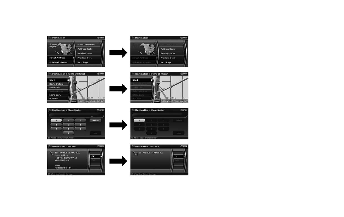
DESTINATION SCREEN
There are several methods you can use to set
your destination. Understand the advantages of
each method and select the best method for
finding and setting your destination.
BASIC OPERATION
1. Push <DEST>.
2. Highlight the preferred destination setting
method and push <ENTER>.
Available setting items
. Street Address:
Searches for a destination by address.
. Points of Interest:
Searches for a destination from various
categories of businesses or locations.
. Home:
Searches for a route from the current
location to the previously stored home
destination.
. Address Book:
Searches for a destination from the list of the
stored locations.
. Nearby Places:
Searches for a business or location near
your vehicle.
. Previous Dest.:
Searches for a destination from the previous
destinations.
Available setting items (Next page
screen)
. Previous Starting Point:
Sets the previous starting point as the
destination.
. Stored Route:
Selects a stored route.
. Phone Number:
Searches for a POI destination by the
telephone number.
INFO:
It will not search for residential phone
numbers.
. Freeway Entrance/Exit:
Searches for a destination from a freeway
entrance/exit.
. Intersection:
Searches for a destination from intersections.
. City Center:
Sets the center of a city as the destination.
4-2 Setting a destination

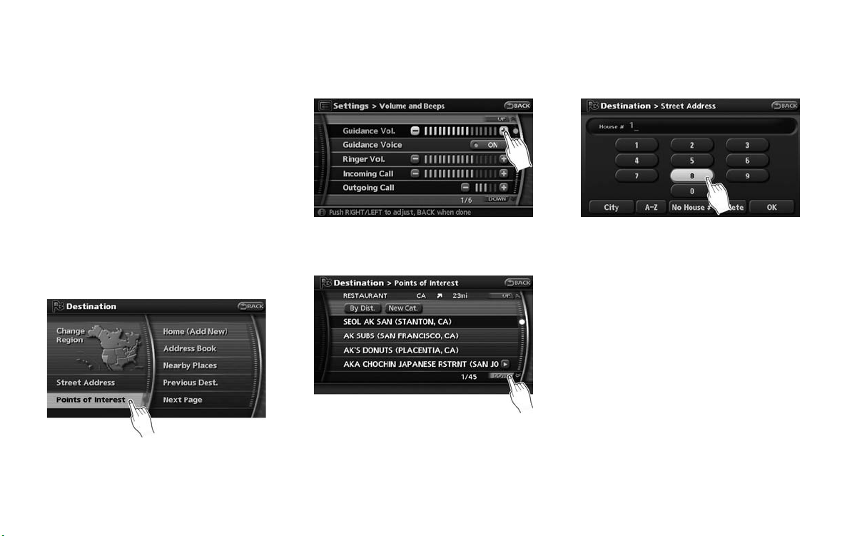
CHANGING THE REGION
When setting a destination, you can narrow
down the place by specifying the region or city.
Specifying the region
1. Push <DEST>.
2. Highlight [Change Re gion] and push
<ENTER>.
3. Highlight the preferred region and push
<ENTER>.
Available setting items
. US1: CA, NV
. US2: AZ, CO, ID, MT, NM, OR, UT, WA, WY
. US3: IA, KS, MN, MO, ND, NE, SD
. US4: AR, LA, MS, OK, TX
. US5: IL, IN, MI, WI
. US6: DC, DE, KY, MD, OH, PA, VA, WV
. US7: CT, MA, ME, NH, NJ, NY, RI, VT
. US8: AL, FL, GA, NC, SC, TN
. US9: AK
. US10: HI
. Canada
INFO:
. It is also possible to select a region by
touching the map on the right side of the
screen.
. It is not possible to search for a route from
the continental United States to Hawaii.
Specifying the city
When searching for a destination with “Street
Address”, “Points of Interest”, “Freeway Entrance/Exit”, “Intersection” or “City Center”, you
can narrow down the search by specifying the
city.
1. Select [City] on input screen and push
<ENTER>.
2. Enter the name of the city, highlight [List]
and push <ENTER>.
A list screen is displayed.
INFO:
Highlight [Last 5 Cities] and push
<ENTER> to display 5 cities recently set
as destinations.
Setting a destination 4-3

3. Highlight the city of the destination from the
list and push <ENTER>.
INFO:
In some cases, when a city name has been
entered, the number of matching destinations in
the “Matches” column may be different from the
number displayed on the list screen. If this
occurs, enter more characters to further reduce
the number of matches.
SETTING A STREET ADDRES S
If you know the address of your destination, use
this method to enter the address and then have
the system calculate a route. You can also
search for a location near the preferred destination by entering the house number if the map
data contains the relevant data.
4-4 Setting a destination
1. Push <DEST>.
2. Highlight [Street Address] and push
<ENTER>. A character input screen is
displayed.
3. Enter the house number, highlight [OK] and
push <ENTER>. If you do not know the
house number, highlight [No House #] and
push <ENTER>. A street name input
screen is displayed.
4. Enter the name of the street. After finishing
the entry, highlight [List] and push
<ENTER>. A list of cities is displayed.
5. Highlight the correct city of the destination
from the list and push <ENTER>.
INFO:
In some cases, when a street name has
been entered, the number of matching
destinations in the “Matches” column may
be different from the number displayed on

the list screen. If this occurs, enter more
characters to further reduce the number of
matches.
6. The selected destination is displayed at the
center of the map. Highlight [Start] after
confirming the location of the displayed
destination, and push <ENTER>.The
system sets the destination to the selected
location and starts calculating a route.
INFO:
Even after setting a destination, you can
adjust the location of the destination, store
the route, etc.
“OPERATIONS AFTER SETTING A
DESTINATION” (page 4-24)
Setting by voice command
1. Push <TALK> located on the steering
switch.
2. After the tone sounds, speak a command.
. To set the destination from street address:
“Destination Street Address”
. To set the destination from state name:
“Destination Street Address <
. To set the destination from last state:
“Destination Street Address Last State”
. To set the destination from last city:
“Destination Street Address Last City”
INFO:
When using a voice command to set a street
name, the complete street name must be stated.
Examples:
Correct input – North Elm Street
East Jefferson Boulevard
Incorrect input – Elm Street
East Jefferson
State
>”
SETTING A POINT OF INTEREST
This allows you to find a facility by type, and then
have the system calculate a route to that
destination. Specify the region and city of the
destination to find it more quickly.
NOTE:
Locations and business hours of facilities
are subject to change, which may not be
reflected in the map data. Double-check
this information before you go to an
emergency facility to ensure that you can
receive the proper support. Otherwise, you
may not receive emergency help even
when you arrive at the destination.
A confirmation message also appears on
the navigation screen. Follow the displayed instructions and check the items
required.
1. Push <DEST>.
Setting a destination 4-5

2. Highlight [Points of Interest] and push
<ENTER>.
3. Select whether to search by directly inputting the facility name, or by selecting from
the landmark category.
Search by inputting a landmark name
1. Highlight [By Name] and push <ENTER>.
A character input screen is displayed.
4-6 Setting a destination
2. Enter the name of the destination facility.
3. After finishing the entry, highlight [List] and
push <ENTER>. A list screen is displayed.
4. Highlight the preferred destination facility
from the list and push <ENTER>.
INFO:
. By selecting [By Dist.], you can sort the
list by the nearest distance.
The position of the selected location is
displayed in the preview on the right
side of the screen.
. In some cases, when a POI name has
been entered, the number of matching
destinations in the “Matches” column
may be different from the number displayed on the list screen. If this occurs,
enter more characters to further reduce
the number of matches.

INFO:
By selecting [By Cat.], you can display the
list that summarizes the entered names into
categories. Select the category to narrow
down the search.
5. The selected destination is displayed at the
center of the map. Highlight [Start] after
confirming the location of the displayed
destination, and push <ENTER>.
The system sets the destination to the
selected location and starts calculating a
route.
INFO:
Even after setting a destination, you can adjust
the location of the destination, store the location,
etc.
“OPERATIONS AFTER SETTING A
DESTINATION” (page 4-24)
Search by selecting from the landmark
category
1. Highlightthemaincategoryandpush
<ENTER>.
2. Highlight the subcategory and push
<ENTER>.
3. Set the narrow down conditions for the
landmarks.
Narrow down conditions:
. Nearby POI
“Narrowing down with Nearby
POI” (page 4-8)
. By Name
“Narrowing down with By Name”
(page 4-8)
Setting a destination 4-7

. By city
“Specifying the city” (page 4-3)
Narrowing down with Nearby POI:
1. Highlight [Nearby POI] and push
<ENTER>. A list screen is displayed.
2. Highlight the preferred destination from the
list, and push <ENTER>. The position of
the selected location is displayed in the
preview on the right side of the screen.
INFO:
By selecting [Sort], you can sort the list in
the original order.
3. The selected destination is displayed at the
center of the map. Highlight [Start] after
confirming the location of the displayed
destination, and push <ENTER>.The
system sets the destination to the selected
location and starts calculating a route.
INFO:
Even after setting a destination, you can adjust
the location of the destination, store the route,
etc.
“OPERATIONS AFTER SETTING A
DESTINATION” (page 4-24)
Narrowing down with By Name:
1. Highlight [By Name] and push <ENTER>.A
character input screen is displayed.
2. Enter the name of the destination facility.
3. After finishing the entry, highlight [OK] and
push <ENTER>. A list screen is displayed.
4-8 Setting a destination

4. Highlight the preferred destination facility
from the list and push <ENTER>.
INFO:
. By selecting [By Dist.], you can sort the
list by the nearest distance. The position
of the selected location is displayed in
the preview on the right side of the
screen.
. In some cases, when a POI name has
been entered, the number of matching
destinations in the “Matches” column
may be different from the number displayed on the list screen. If this occurs,
enter more characters to further reduce
the number of matches.
INFO:
By selecting [New Cat.], you can perform a
search from another category.
5. The selected destination is displayed at the
center of the map. Highlight [Start] after
confirming the location of the displayed
destination, and push <ENTER>.The
system sets the destination to the selected
location and starts calculating a route.
INFO:
Even after setting a destination, you can adjust
the location of the destination, store the location,
etc.
“OPERATIONS AFTER SETTING A
DESTINATION” (page 4-24)
Setting a destination 4-9

Category list:
Restaurant
Shopping
Auto service
Restaurant all
African, American, Austrian, Balkan, Barbecue/Southern, Belgian, Bistro, Bohemian, Brewpub, British isles, Cajun/Caribbean, Californian, Canadian,
Chinese, Continental, Dutch, East European, Fast food, Filipino, French, German, Greek, Grill, Hawaiian/Polynesian, Hungarian, Indian, Indonesian/
Malaysian, International, Italian, Japanese, Jewish/Kosher, Korean, Latin American, Maltese, Mexican, Middle Eastern, Oriental, Other, Pizza, Polish,
Portuguese, Russian, Sandwich, Scandinavian, Seafood, Soul food, South American, South-western, Southeast Asian, Spanish, Steak house,
Swiss, Thai, Turkish, Vegetarian, Vietnamese
Grocery store
Convenience stores all
Convenience stores
Shopping (others)
Auto dealerships
Automobile club
Gas station
Rental car agency
Auto service & maintenance
NISSAN dealer
INFINITI dealer
7-Eleven, AM PM, Casey’s General Store, Circle K, Convenient Food Stores, Cumberland Farms, Dairy Mart,
Dominion stores, Holiday Station Store, JR Food store, Kash-N-Karry, Loblaw, Miracle Mart, Others, Pantry,
Steinberg, Stop-N-Go, Uni Mart Inc., White Hen Pantry
Gas station all
Amoco, Arco, Beacon (Valero), BP, Chevron, Citgo, Conoco, Diamond Shamrock, Esso, Exxon, Fina, Getty, Gulf,
Husky, Marathon, Mobil, Mohawk, Others, Petro-Canada, Phillips 66, Pioneer, Shamrock, Shell, Sinclair,
Speedway, Sunoco, Superamerica, Texaco, Ultramar USA, Ultramar (Valero), Unocal 76, Valero
4-10 Setting a destination

Travel
Airport
Border crossing
Bus station
Commuter rail station
Ferry terminal
Hotel
Automobile club
Rental car agency
Rest area
Ski resort
Tourist attraction
Tourist information
Train station
Auto service & maintenance
Hotel all
America Inn & Suites, Amerihost (Cendant) , Amerisuites, Baymont Inn & Suites, Best Western, Candlewood
Suites, Clarion, Country Hearth Inn, Country Inn Suites (Carlson Group), Courtyard by Marriott, Crossland Motel,
Crowne Plaza, Days Inn, Double Tree (Hilton Group), Drury Inn/Pear Tree by Drury, Econo Lodge, Embassy
Suites, Extended Stay, Fairfield Inn, Four Seasons, Hampton Inn, Hawthorn Suites, Hilton, Hilton Garden Inn,
Holiday Inn, Holiday Inn Express, Homestead, Homewood, Howard Johnson, Hyatt, Intercontinental, Jameson
Inns/Signature Inns, Knights Inn (Cendant) , La Quinta Inn, Leows Hotels, Mainstay Suites (Choice), Microtel Inn &
Suites, Motel 6/Studio 6, Others, Park Inn (Carlson Group), Quality, Radisson, Ramada Inn, Red Roof Inn, Relax
Inns, Renaissance (Marriott), Residence Inns, Ritz Carlton, Rodeway Inn (Choice), Scottish Inn, Sheraton, Shilo
Inn, Shoney’s Inn, Sleep Inn (Choice), Spring Hill Suites (Marriott), St Regis (Starwood), Staybridge Suites,
Studio Plus, Super 8, TownePlace Suites (Marriott), Travelodge, Village (Cendant), W Hotels, Westin, Wingate
Inn (Cendant) , Wyndham
Setting a destination 4-11

Banking
Hospital
Community
Leisure
Parking
Others
ATM
Bank
City hall, Community center, Convention/Exhibition center, Court house, Historical monument, Hospital, Library, Marina, Museum, Police station,
Park/Recreation area, School, Sports center, Sports complex, Performing arts, Higher education
Amusement park, Bowling center, Casino, Movie theater, Convention/Exhibition center, Golf course, Historical monument, Ice skating rink, Marina,
Museum, Nightlife, Park/Recreation area, Ski resort, Sports center, Sports complex, Performing arts, Tourist attraction, Tourist information, Winery
Parking lot
Park & Ride
Parking garage
Border crossing, Business facility, Court house, Historical monument, Police station, School, Higher education
4-12 Setting a destination

SETTING YOUR HOME
This allows you to set your home as the
destination and have the system calculate a
route. It is useful especially when you are
searching for a route to return to your home.
INFO:
If you have not stored your home yet, the
system will automatically display a screen for
storing it.
“STORING A LOCATION” (page 6-2)
SETTING FROM ADDRESS BOOK
This allows you to set the destination to a
location stored in the Address Book and have
the system calculate a route. To utilize this
function more effectively, destinations that you
often travel to should be stored in advance.
1. Push <DEST>.
2. Highlight [Home] and push <ENTER>.
3. A confirmation message is displayed, and
the system sets your home as the destination.
4. Your home is displayed at the center of the
map. Highlight [Start] after confirming the
location of the displayed destination, and
push <ENTER>. The system sets the
destination to the selected location and
starts calculating a route.
Setting by voice command
1. Push <TALK> located on the steering
switch.
2. After the tone sounds, speak a command.
To set your home as the destination:
“Destination Home”
1. Push <DEST>.
2. Highlight [Address Book] and push
<ENTER>. A list screen is displayed.
3. Highlight the preferred location from the list
Setting a destination 4-13

and push <ENTER>.
INFO:
. Selecting [Sort List] displays a list of
various sort functions.
To use the sort functions, stored locations must be set in advance.
“EDITING THE STORED HOME
AND LOCATION” (page 6-9)
. Select [Play All] to play back the stored
voicetag.
INFO:
1
&
Sort by number:
The Address Book entries are displayed
in ascending numerical order.
2
&
Sort by name:
The Address Book entries are displayed
in alphabetic order.
3
&
Sort by icon:
By selecting a particular icon, a list that
contains only the Address Book entries
associated with that icon is displayed.
4
&
Sort by group:
By selecting a particular group (family,
friends, leisure, etc.), the selected group
is displayed at the top of the list.
4. The selected destination is displayed at the
center of the map. Highlight [Start] after
confirming the location of the displayed
destination, and push <ENTER>.The
system sets the destination to the selected
location and starts calculating a route.
INFO:
Even after setting a destination, you can adjust
the location of the destination, store the route,
etc.
“OPERATIONS AFTER SETTING A
DESTINATION” (page 4-24)
Setting by voice command
1. Push <TALK> located on the steering
switch.
2. After the tone sounds, speak a command.
. To set the destination from the Address
Book:
“Destination Address book”
. To set the destination from a voicetag:
“Destination <
voicetag
>”
SETTING A NEARBY PLACE
This allows you to set the destination to a facility
located near the current vehicle location or
another location that you move to by scrolling
the map, and then have the system calculate a
route.
If there is any particular Points of Interest type
that you intend to use frequently, you can store it
in the list of nearby Points of Interest.
“CUSTOMIZING NEARBY PLACES”
(page 8-5)
4-14 Setting a destination

1. Push <DEST>.
2. Highlight [Nearby Places] and push
<ENTER>.
3. Highlight the preferred destination Points of
Interest and push <ENTER>.
A list screen is displayed.
4. Highlight the preferred destination from the
list, and push <ENTER>.
The position of the selected location is
displayed in the preview on the right side
of the screen.
INFO:
. If the suggested route is already set, by
highlighting [Show Along Route] and
pushing <ENTER>, the system displays
only the facilities located along the
route.
. A maximum of 100 facilities can be
displayed on the list screen.
5. The selected destination is displayed at the
center of the map. Highlight [Start] after
confirming the location and push
<ENTER>. The system sets the destination
to the selected location and starts calculating a route.
INFO:
If the route is already set, the selected location
becomes a waypoint.
Other settings
Setting a destination 4-15

You can also set the destination by pushing
<ENTER> in the current location map screen
and selecting [Nearby].
Setting by voice command
1. Push <TALK> located on the steering
switch.
2. After the tone sounds, speak a command.
. To display the 5 nearest Points of Interest
and select the destination from them:
“Show nearby <
. To display the nearby category list and
select the destination from it:
“Destination Nearby Places”
“Destination Nearby <
POI Category
POI Category
>”
>”
SETTING A PREVIOUS DESTINATION
This allows you to set the destination to a
location that you have previously set as the
destination and have the system calculate a
route. Up to 100 previous destinations will be
automatically stored.
If the number of previous destinations exceeds
100, the oldest one will be replaced by the new
one.
1. Push <DEST>.
2. Highlight [Previous Dest.] and push
<ENTER>. A list screen is displayed.
3. Highlight the preferred destination from the
list and push <ENTER>.
4. The selected destination is displayed at the
center of the map. Highlight [Start] after
confirming the location of the displayed
destination, and push <ENTER>.The
system sets the destination to the selected
location and starts calculating a route.
INFO:
Even after setting a destination, you can adjust
the location of the destination, store the route,
etc.
“OPERATIONS AFTER SETTING A
DESTINATION” (page 4-24)
Setting by voice command
1. Push <TALK> located on the steering
switch.
2. After the tone sounds, speak a command.
To display the Previous Destinations list:
“Destination Previous Destinations”
4-16 Setting a destination

SETTING THE PREVIOUS STARTING
POINT
This allows you to set the destination to the
starting point of the previous route guidance and
have the system calculate a route.
1. Push <DEST>.
2. Highlight [Next Page] and push <ENTER>.
3. Highlight [Previous Starting Point] and push
<ENTER>.
4. The starting point of the route of the
previous route guidance is displayed at the
center of the map. Highlight [Start] after
confirming the location of the displayed
destination, and push <ENTER>.
The system sets the destination to the
selected location and starts calculating a
route.
INFO:
Even after setting a destination, you can adjust
the location of the destination, store the route,
etc.
“OPERATIONS AFTER SETTING A
DESTINATION” (page 4-24)
Setting by voice command
1. Push <TALK> located on the steering
switch.
2. After the tone sounds, speak a command.
To set the previous start point as the destination:
“Destination Previous Start Point”
SETTING FROM STORED ROUTES
You can select a preferred route from the stored
routes.
1. Push <DEST>.
2. Highlight [Next Page] and push <ENTER>.
3. Highlight [Stored Routes] and push
<ENTER>. A list screen is displayed.
Setting a destination 4-17

4. Highlight the preferred route from the list
and push <ENTER>. The route to the
destination is set.
INFO:
. Even after setting a destination, you can
adjust the location of the destination, store
the location, etc.
“OPERATIONS AFTER SETTING A
DESTINATION” (page 4-24)
. The stored route includes only locations
(destination and waypoints) and route calculation conditions, not the route itself.
Therefore, when the destination is set using
a stored route, a different route may be
suggested if the current vehicle location is
different from the one when the route was
stored.
SETTING BY PHONE NUMBER
If you know the telephone number of the facility,
use this to find the facility by entering the
number, and then have the system calculate a
route.
in the map data can be searched by the
phone number. Personal phone numbers
cannot be used to search for a location.
1. Push <DEST>.
2. Highlight [Next Page] and push <ENTER>.
5. The selected destination is displayed at the
center of the map. Highlight [Start] after
confirming the location of the displayed
destination, and push <ENTER>.The
system sets the destination to the selected
location and starts calculating a route.
4-18 Setting a destination
INFO:
. Telephone numbers that were stored for
stored destinations can also be used.
. If the area code of the specified telephone
number does not exist in the map data, the
system will not search for the location.
. Only the locations included in the database
3. Highlight [Phone Number] and push
<ENTER>. The telephone number input
screen is displayed.

SETTING A FREEWAY ENTRANCE/
EXIT
This allows you to set the destination to an
entrance or exit of a freeway, and then have the
system calculate a route.
4. Enter the telephone number including the
area code.
5. After finishing the entry, highlight [Map] and
push <ENTER>.
“PHONE NUMBER INPUT SCREEN”
(page 2-21)
6. Displays a list screen if there are two or
more search results. Highlight the preferred
destination from the list and push
<ENTER>.
7. The selected destination is displayed at the
center of the map. Highlight [Start] after
confirming the location of the displayed
destination, and push <ENTER>.The
system sets the destination to the selected
location and starts calculating a route.
INFO:
Even after setting a destination, you can adjust
the location of the destination, store the route,
etc.
“OPERATIONS AFTER SETTING A
DESTINATION” (page 4-24)
Setting by voice command
1. Push <TALK> located on the steering
switch.
2. After the tone sounds, speak a command.
To set the destination from Phone Number:
“Destination Phone Number”
1. Push <DEST>.
2. Highlight [Next Page] and push <ENTER>.
3. Highlight [Freeway Entrance/Exit] and push
<ENTER>. A character input screen is
displayed.
Setting a destination 4-19

4. Select a region and enter the name of the
freeway.
5. After finishing the entry, highlight [List] and
push <ENTER>.
6. Highlight the freeway of the destination from
the list, and push <ENTER>.
4-20 Setting a destination
7. Highlight [Entrance] or [Exit] and push
<ENTER>. A list screen is displayed.
8. Select the preferred destination from the list.
The position of the selected location is
displayed in the preview on the right side
of the screen. Then, push <ENTER>.
INFO:
By selecting [By Distance], you can sort the
list by the nearest distance.
9. The selected destination is displayed at the
center of the map. Highlight [Start] after
confirming the location of the displayed
destination, and push <ENTER>.The
system sets the destination to the selected
location and starts calculating a route.

INFO:
Even after setting a destination, you can adjust
the location of the destination, store the route,
etc.
“OPERATIONS AFTER SETTING A
DESTINATION” (page 4-24)
SETTING AN INTERSECTION
This allows you to set the destination to an
intersection of any two streets, and then have
the system calculate a route.
3. Highlight [Intersection] and push
<ENTER>. A character input screen is
displayed.
5. Highlight a street as the 1st street from the
list and push <ENTER>. A character input
screen is displayed.
1. Push <DEST>.
2. Highlight [Next Page] and push <ENTER>.
4. Enter the name of the 1st street.
After finishing the entry, highlight [List] and
push <ENTER>. A list screen is displayed.
6. Enter the name of the 2nd street.
After finishing the entry, highlight [List] and
push <ENTER>. A list screen is displayed.
Setting a destination 4-21

7. Highlight a street as the 2nd street from the
list and push <ENTER>.
INFO:
Even after setting a destination, you can adjust
the location of the destination, store the route,
etc.
“OPERATIONS AFTER SETTING A
DESTINATION” (page 4-24)
SETTING A CITY CENTER
This allows you to have the system calculate a
route to the center of a city, without setting a
specific location.
3. Highlight [City Center] and push
<ENTER>. A character input screen is
displayed.
8. The selected destination is displayed at the
center of the map. Highlight [Start] after
confirming the location of the displayed
destination, and push <ENTER>.The
system sets the destination to the selected
location and starts calculating a route.
4-22 Setting a destination
1. Push <DEST>.
2. Highlight [Next Page] and push <ENTER>.
4. Enter the name of the city, highlight [List]
and push <ENT ER>. A list screen is
displayed.
INFO:
Highlight [Last 5 Cities] and push
<ENTER> to display 5 cities recently set
as destinations.

SETTING FROM MAP
This allows you to search for a destination by
scrolling the map, and then have the system
calculate a route to the destination.
5. Highlight the preferred destination from the
list and push <ENTER>. The position of the
selected location is displayed in the preview
on the right side of the screen.
INFO:
By selecting [By Dist.], you can sort the list
by the nearest distance.
6. The selected destination is displayed at the
center of the map. Highlight [Start] after
confirming the location of the displayed
destination, and push <ENTER>.
The system sets the destination to the
selected location and starts calculating a
route.
INFO:
Even after setting a destination, you can
adjust the location of the destination, store
the route, etc.
“OPERATIONS AFTER SETTING A
DESTINATION” (page 4-24)
1. Scroll the map, place the cross pointer over
the preferred location, and push <ENTER>.
INFO:
. Adjust the map scale to search for a
location more effectively.
. The point on the blinking road where the
center of the cross pointer is located
can be set as a destination.
Setting a destination 4-23

OPERATIONS AFTER SETTING A
DESTINATION
The following operations are available after you
set a destination.
2. Highlight [New Dest.] and push <ENTER>.
INFO:
For the items except for [New Dest.], refer to
“Map menu screen”.
“SCROLLED LOCATION MAP
SCREEN” (page 2-12)
3. The system sets the destination to the
selected location and starts calculating a
route.
4-24 Setting a destination
INFO:
If you set the destination on a freeway, a
confirmation message is displayed.
INFO:
The menu will not be displayed if you select,
[Stored Route] or [Nearby Places] from the
Destination menu.

AVAILABLE SETTING ITEMS
. Start:
Sets the destination. If the route is already
set, the location becomes the new destination, and the route is recalculated.
. Route Details:
Allows you to change the route search
conditions or to check the route information.
“PROCEDURES AFTER SETTING A
DESTINATION” (page 5-2)
. Move Dest.:
Displays a map screen where you can adjust
the location of the destination.
. Add to Route:
Allows you to add a waypoint to the route
already set.
. Store Dest.:
Allows you to store the location in the
Address Book.
. POI Info.:
Allows you to view information about the
facility that you have set as the destination if
it is included in the map data.
ADJUSTING THE LOCATION OF THE
DESTINATION
You can adjust the location of the destination by
moving the cross pointer across the map.
1. Set the destination using an appropriate
method.
2. Highlight [Move Dest.] and push <ENTER>.
3. Adjust the location by moving the cross
pointer across the map and push
<ENTER>. The location of the destination
is modified.
INFO:
. Touching the map screen displayed on the
right side of the screen also changes to the
screen for adjusting the location.
. The map scale can be changed by pushing
<ZOOM IN> or <ZOOM OUT>. Touching
the scale icon can also be used to change
the map scale.
. Even if you touch the map screen or operate
the directional buttons other than the up or
down button, the same map screen as when
[Move Dest.] is selected is displayed.
Setting a destination 4-25

ADDING ADDITIONAL DESTINATIONS
TO A ROUTE
Even after the route is already set, you can add a
searched location as a new destination or
waypoint to that route.
If the route has not been set, [Add to Route]
cannot be selected.
1. Set the destination using an appropriate
method.
2. Highlight [Add to Route] and push
<ENTER>.
4-26 Setting a destination
3. Highlight [Destination] or [Waypoint] and
push <ENTER>.
STORING A LOCATION
A searched location can be stored in the
Address Book. Then it can be easily retrieved
and set as a destination (or waypoint).
1. Set the destination using an appropriate
method.
2. Highlight [Store Dest.] and push <ENTER>.
3. The location is stored in the Address Book.
The corresponding icon is displayed at the
set location on the map.
VIEWING INFORMATION ABOUT THE
SEARCHED LOCATION
Information (street address and phone number)
about Points of Interest stored in the map data
can be displayed.
1. Set the destination using an appropriate
method.

2. Highlight [POI Info.] and push <ENTER>.
3. Information about the location is displayed.
4. Push <BACK>, or highlight [OK] and push
<ENTER> to return to the previous screen.
INFO:
. If [call] is displayed on the right side of the
screen, it is possible to call the location
indicated.
. The Bluetooth system is required to be
active and paired to the call location
indicated.
. Information about locations is not displayed
while driving.
Setting a destination 4-27

MEMO
4-28 Setting a destination

5 Route guidance
Procedures after setting a destination ..................... 5-2
Available items after setting a destination............. 5-2
Starting route guidance ................................... 5-2
Selecting a route ........................................... 5-2
Confirming a route.......................................... 5-3
Adding a destination or waypoint ....................... 5-4
Route screen .................................................... 5-5
Basic operation ............................................. 5-5
Deleting/reactivating a route ............................. 5-6
Editing a route............................................... 5-7
Confirming a route........................................ 5-11
Searching for a detour route taking traffic
information into consideration .......................... 5-12
Setting conditions for the route calculation......... 5-14
Recalculate route ......................................... 5-16
Setting a detour route ................................... 5-17
Route guidance settings ................................ 5-18
About route guidance........................................ 5-23
Voice guidance during route guidance. .............. 5-23
Guidance screens and preview mode ............... 5-24

PROCEDURES AFTER SETTING A
DESTINATION
After performing the route search, you can
immediately start the route guidance. Also, it is
possible to confirm or change the route.
AVAILABLE ITEMS AFTER SETTING A
DESTINATION
. Start:
Starts route guidance to the selected
destination.
“STARTING ROUTE GUIDANCE”
(page 5-2)
. More Routes:
Displays 3 alternative routes.
“SELECTING A ROUTE” (page 5-2)
. Route Info:
Displays the route information.
“CONFIRMING A ROUTE”
(page 5-3)
. Add Way Pt.:
Allows you to edit the route by adding a
destination or waypoint.
“ADDING A DESTINATION OR
WAYPOINT” (page 5-4)
. Map Scroll:
Displays a map screen where you can
confirm the location of the destination.
INFO:
. If you have not performed any operations on
the system for several seconds, [Start] is
automatically selected, and the system
starts route guidance.
. When a waypoint has already been set, you
cannot select [More Routes].
. Even if you touch the map screen or operate
the directional buttons other than the up or
down button, the same map screen as when
[Map Scroll] is selected is displayed.
STARTING ROUTE GUIDANCE
1. Highlight [ Start] and push <ENTER>.
Route guidance starts.
SELECTING A ROUTE
1. Highlight [More Routes] and push
<ENTER>.
2. Highlight the preferred route condition and
push <ENTER>.
5-2 Route guidance

3. Push <BACK> to return to the previous
screen.
Available route conditions
1
&
Short. Time (Blue):
Prioritizes by the shortest time.
2
&
Min. FWY (Red):
Minimizes the use of freeways.
3
&
Short. Dist. (Green):
Prioritizes by the shortest distance.
4
&
Map Scroll:
Displays a map screen where you can
confirm the location of the destination.
Even if you touch the map screen or operate
the directional buttons other than the up or
down button, the same map screen as when
[Map Scroll] is selected is displayed.
INFO:
. After you select a route, a preview is
displayed on the right side of the screen.
. The 3 routes may not always be different.
CONFIRMING A ROUTE
1. Highlight [Route Info.] and push <ENTER>.
2. Highlight the preferred information item and
push <ENTER>.
3. Push <BACK> to return to the previous
screen.
Available information
. Turn list:
Displays the details of the suggested route.
“Using turn list” (page 5-11)
. Preview:
Allows you to confirm the route by scrolling
on the map manually.
“Using route preview” (page 5-12)
. Simulation:
Allows you to view a simulation of the route.
“Confirming by simulation”
(page 5-12)
. Store route:
A calculated route can be stored. A maximum of 5 routes can be stored. Stored
routes can be easily retrieved and set as the
suggested route.
“STORING A ROUTE” (page 6-5)
Route guidance 5-3

. Map Scroll:
Displays a map screen where you can
confirm the location of the destination.
Even if you touch the map screen or operate
the directional buttons other than the up or
down button, the same map screen as when
[Map Scroll] is selected is displayed.
ADDING A DESTINATION OR WAYPOINT
Before starting route guidance, you can add
destinations and/or waypoints. A total of 6
destinations or waypoints can be set.
1. Highlight [Add Way Pt.] and push
<ENTER>.
INFO:
You can modify the location by selecting
[Alter Location]. The method of adjusting a
location is the same as the one for a
destination.
“ADJUSTING THE LOCATION OF
THE DESTINATION” (page 4-25)
2. Set additional destinations or waypoints and
push <ENTER>.
INFO:
The method of searching for a location is the
same as the one for a destination.
“4. Setting a destination”
4. Highlight [Destination] or [Waypoint] and
push <ENTER>.
The system starts calculating a route that
includes the added destination or waypoint.
When the calculation is finished, the route is
displayed.
3. The selected location is displayed at the
center of the map. Highlight [Add to Route]
after confirming the location and push
<ENTER>.
5-4 Route guidance

ROUTE SCREEN
INFO:
. If a waypoint was added, [More Routes]
cannot be selected.
. If a destination was added, the prior
destination becomes a waypoint.
During route guidance, you can modify the route
conditions or confirm the route information. Set
the appropriate route condition according to
your purpose.
BASIC OPERATION
1. Push <ROUTE>.
2. Highlight the preferred setting item and
push <ENTER>.
3. Push <MAP> to return to the current
location map screen.
WARNING
Always stop the vehicle in a safe
location before modifying the route
conditions.
Modifying the route conditions while
driving may cause an accident.
Available setting items
. Cancel Route/Resume Route:
Allows you to cancel the current route
guidance. A cancelled route can also be
reactivated. If the suggested route is cancelled, [Cancel Route Guidance] changes to
[Resume Route Guidance].
“DELETING/REACTIVATING A
ROUTE” (page 5-6)
. Edit:
Allows you to edit the route already set.
“EDITING A ROUTE” (page 5-7)
. Route Information:
Allows you to confirm the route by the route
information or simulation.
“CONFIRMING A ROUTE”
(page 5-11)
. Traffic Detour:
Allows you to manually search for an
alternative detour route taking the traffic
information into consideration.
“SEARCHING FOR A DETOUR
ROUTE TAKING TRAFFIC INFORMATION INTO CONSIDERATION”
(page 5-12)
Route guidance 5-5

. Route Settings:
Allows you to change the route calculation
conditions anywhere along the route.
“SETTING CONDITIONS FOR THE
ROUTE CALCULATION” (page 5-14)
. Recalculate:
You can manually search for the route again
after changing the search condition.
“RECALCULATE ROUTE”
(page 5-16)
. Detour:
If you want to detour from the suggested
route, you can calculate a route detouring for
a specified distance.
“SETTING A DETOUR ROUTE”
(page 5-17)
. Guidance Settings:
You can set various guidance information to
be displayed during route guidance and
activate or deactivate route and/or voice
guidance.
“ROUTE GUIDANCE SETTINGS”
(page 5-18)
DELETING/REACTIVATING A ROUTE
You can delete a route already set at any time. If
you delete a route, the destination and waypoints are also deleted.
It is also possible to reactivate the route that you
deleted.
Deleting a route
1. Push <ROUTE>.
2. Highlight [Cancel Route] and push
<ENTER>.
3. A confirmation message is displayed. Highlight [Yes] and push <ENTER>.
The route is deleted along with the destination and waypoints.
Setting by voice command
1. Push <TALK> located on the steering
switch.
2. After the tone sounds, speak a command.
To delete a route:
“Cancel Route”
Reactivating a route
1. Push <ROUTE>.
2. Highlight [Resume Route ] and push
<ENTER>.
5-6 Route guidance

3. A confirmation message is displayed. Highlight [Yes] and push <ENTER>. The route
you have deleted is reactivated.
INFO:
If you set a new route, the deleted route cannot
be reactivated.
EDITING A ROUTE
1. Push <ROUTE>.
2. Highlight [Edit] and push <ENTER>.
3. Highlight the preferred condition and push
<ENTER>.
4. Push <BACK> to return to the previous
screen. Push <MAP> to return to the
current location map screen.
Available setting items
1
&
Current destination:
Allows you to change or delete the destination.
“Editing/deleting a destination or waypoint” (page 5-9)
2
&
Current waypoint:
Allows you to change or delete the waypoint.
“Editing/deleting a destination or waypoint” (page 5-9)
3
&
Condition for calculating a route to the
destination:
Allows you to change the conditions for
calculating a route to the destination.
“Changing route calculation conditions”
(page 5-10)
4
&
Condition for calculating a route to a
waypoint:
Allows you to change the conditions for
calculating a route to a waypoint.
“Changing route calculation conditions” (page 5-10)
5
&
Allows you to add a destination.
“Setting a destination or waypoint”
(page 5-8)
6
&
Allows you to add a waypoint.
“Setting a destination or waypoint”
(page 5-8)
Route guidance 5-7

Setting a destination or waypoint
You can add a destination or waypoint to the
route already set. A total of 6 destinations or
waypoints can be set.
1. Push <ROUTE>.
2. Highlight [Edit] and push <ENTER>.
3. Highlight [Destination] or [Waypoint] and
push <ENTER>.
INFO:
If you select [Destination], the current
destination changes to a waypoint.
4. Set a destination or waypoint. The method of
searching for a destination or waypoint is the
same as the one for a destination.
“4. Setting a destination”
5. The selected location is displayed at the
center of the map. Highlight [Add to Route]
after confirming the location and push
<ENTER>.
INFO:
Even after setting a destination/waypoint,
you can adjust the destinat ion/waypoint
location, store the route, etc.
“OPERATIONS AFTER SETTING A
DESTINATION” (page 4-24)
6. Return to the Edit Route screen. Set the
route conditions as necessary.
7. Push <MAP> to return to the current
location map screen. The route you have
set is automatically displayed.
INFO:
The prior route is automatically deleted.
5-8 Route guidance

Editing/deleting a destination or waypoint
You can modify or delete the destination or
waypoint already set.
INFO:
If you modify or delete a location when a
suggested route is already set, the prior
suggested route will be recalculated accordingly.
1. Push <ROUTE>.
2. Highlight [Edit] and push <ENTER>.
3. Highlight a destination or waypoint that is
already set and push <ENTER>.
4. Highlight [Move Dest.] to modify the location
and push <ENTER>.
“ADJUSTING THE LOCATION OF
THE DESTINATION” (page 4-25)
5. Highlight [Delete] and push <ENTER> to
delete the location.
6. A confirmation message is displayed. Confirm the contents of the message, highlight
[Yes] and push <ENTER>. The destination
or waypoint is deleted from the route.
INFO:
. If the destination is deleted, the final
waypoint of the route becomes the destination.
. Even if you touch the map screen or operate
the directional buttons other than the up or
down button, the same map screen as when
[Move Dest.] is selected is displayed.
Route guidance 5-9

Changing route calculation conditions
Each section of the route between waypoints
can have different route calculation conditions.
After setting these conditions, you can recalculate the entire route.
1. Push <ROUTE>.
2. Highlight [Edit] and push <ENTER>.
3. Highlight the preferred section of the route
to the destination or waypoint and push
<ENTER>.
5-10 Route guidance
4. Highlight the preferred condition and push
<ENTER>.
Available conditions:
: Fastest Route
: Minimize Freeway
: Shortest Route
5. The system automatically recalculates a
route according to the conditions set.
The screen will automatically return to the
[Edit] screen after route calculation.
6. The icon corresponding to the set route
condition is displayed. Push <MAP> to
return to the current location map screen.
INFO:
. The recalculated route may not be the
shortest route because the system prioritizes easy-to-drive roads for safety reasons.
. If you set the route conditions from [Route
Settings], all sections in the route are
subject to the same route conditions even
though you have set different route conditions for different sections in [Edit].

CONFIRMING A ROUTE
When the suggested route is displayed after
calculation, you can confirm the route information or simulate the suggested route.
Basic operation
1. Push <ROUTE>.
2. Highlight [Route Information] and push
<ENTER>.
3. Highlight the preferred item and push
<ENTER>.
Available items:
. Turn List:
Displays the details of the suggested route.
“Using turn list” (page 5-11)
. Preview:
Allows you to confirm the suggested route
by scrolling the map.
“Using route preview” (page 5-12)
. Simulation:
Allows you to simulate the suggested route.
This function provides a detailed image of
the route with voice guidance.
“Confirming by simulation”
(page 5-12)
. Store Route:
A calculated route can be stored. A maximum of 5 routes can be stored. Stored
routes can be easily retrieved and set as the
suggested route.
“STORING A ROUTE” (page 6-5)
. Map Scroll:
Displays a map screen where you can
confirm the location of the destination.
Even if you touch the map screen or operate
the directional buttons other than the up or
down button, the same map screen as when
[Map Scroll] is selected is displayed.
Setting by voice command
1. Push <TALK> located on the steering
switch.
2. After the tone sounds, speak a command.
To display the route information:
“Route Information”
Using turn list
1. Highlight [Turn List] and push <ENTER>.
2. You can confirm the information (e.g., intersections) on the route to the destination by
scrolling the screen using the up and down
switches of the main directional buttons or
the center dial.
3. Push <MAP> to return to the current
location map screen.
Route guidance 5-11

Using route preview
1. Highlight [Preview] and push <ENTER>.
2. Highlight the preferred key and push
<ENTER>.
:Goes forward in the direction of the
destination.
:Goes backward in the direction of
the starting point.
:Pauses the route preview.
3. Push <MAP> to cancel the preview and
return to the current location map screen.
While the map scale is being changed, the route
preview is temporarily stopped.
Confirming by simulation
1. Highlight [Simulation] and press <ENTER>.
2. Highlight the preferred key and push
<ENTER>.
:Pauses the simulation.
:Resumes the simulation.
:Ends the simulation.
3. Push <MAP> to cancel the simulation and
return to the current location map screen.
While the map scale is being changed, the
simulation is temporarily stopped.
SEARCHING FOR A DETOUR ROUTE
TAKING TRAFFIC INFORMATION INTO
CONSIDERATION
When a serious traffic event occurs on the route,
or if the system finds a faster route, a detour alert
will pop up automatically. If you miss the
automatic alert, you can also manually search
for a detour.
1. Push <ROUTE>.
2. Highlight [Traffic Detour] and push
<ENTER>.
INFO:
During route preview, you can change the map
scale by pushing <ZOOM IN> or <ZOOM
OUT>.
5-12 Route guidance
INFO:
During simulation, you can change the map
scale by pushing <ZOOM IN> or <ZOOM
OUT>.

3. When the detour search is successful,
detailed information about the detour route
(left screen) and the comparison screen of
the two routes (right screen) are displayed.
1
&
Yellow: Original route
2
&
Pink: Detour route
3
&
The change of distance and estimated
travel time to destination when the
detour route is taken.
4. If you want to accept the suggested detour
route, select [Yes], and then push
<ENTER>.
INFO:
. If no route is set, or “Use Traffic for Route
Calculation” is turned off, this function
cannot be operated.
. If you do not select the detour route and
provide no further action, the detour route
will be automatically cancelled.
. You can try to retrieve the detour suggestion
even after the message disappears by
manually selecting “Traffic Detour”. The
system will then search for the detour again
and suggest a detour if one is available at
that time.
. If you have not subscribed to XM
. See “NOTES ON TRAFFIC INFORMA-
TM
Traffic
traffic detour or apply settings for traffic
information related functions. A message
appears when a related menu item is
selected.
TION” for further information.
, it will not be possible to get a
®
Nav-
Automatic detour guidance
When “Auto Reroute” and “Use Traffic for Route
Calculation” are turned on, a message will
automatically pop up when the system finds a
detour.
1. If a traffic jam or a serious traffic problem
occurs on the route while driving along the
suggested route, the automatic detour route
search starts and a message pops up if a
detour is found. To confirm the detour route,
highlight [Yes] and push <ENTER>.
2. If you want to accept the suggested detour
route, highlight [Yes] and push <ENTER>.
Route guidance 5-13

INFO:
. If no operation is performed for one minute
after the message is displayed, the message
disappears. The detour will not be accepted,
and the current suggested route will remain
unchanged.
. When the “Traffic Announcement” function
is turned on, you will hear the voice
guidance at the same time that the message
appears on the screen.
SETTING CONDITIONS FOR THE
ROUTE CALCULATION
The route can be recalculated after changing the
route calculation conditions anywhere along the
route.
Basic operation
1. Push <ROUTE>.
2. Highlight [Route Settings] and push
5-14 Route guidance
<ENTER>.
3. Highlight the preferred condition and push
<ENTER>. The indicator for the selected
condition illuminates.
4. When the current location map screen or
route setting screen is displayed, the system
recalculates a route with the set conditions.
Available conditions
. Fastest Route:
Prioritizes by the fastest time.
. Minimize Freeway:
Minimizes the use of freeways.
. Shortest Route:
Prioritizes by the shortest route.
INFO:
Only one of these conditions can be utilized at a
time.
Setting by voice command
1. Push <TALK> located on the steering
switch.
2. After the tone sounds, speak a command.
To set conditions for the route calculation:
“Fastest Route”
“Minimize Freeway”
“Shortest Route”
Detailed route settings
Detailed conditions can be set for the route
calculation.
Basic operation:
1. Push <ROUTE>.
2. Highlight [Route Settings] and push
<ENTER>.
3. Highlight [Detailed Route Settings] and
push <ENTER>.
4. Highlight the preferred condition and push
<ENTER>. The indicator for the selected
condition illuminates.
5. When the current location map screen or
route setting screen is displayed, the system
recalculates a route with the set conditions.
 Loading...